62
Volume III: Community Plans Community Character Manual Adopted June 22, 2015 Amended August 24, 2017 A General Plan for Nashville & Davidson County
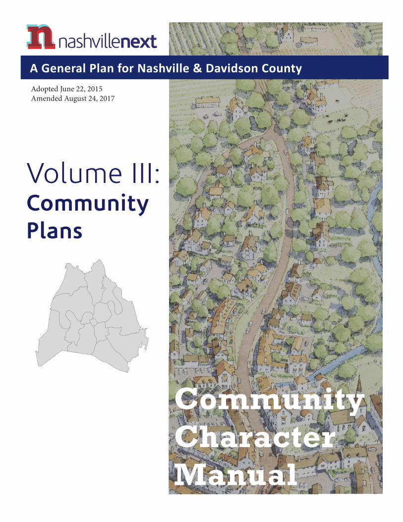
Volume III:CommunityPlans
CommunityCharacterManual
Adopted June 22, 2015Amended August 24, 2017
A General Plan for Nashville & Davidson County
PAGE LEFT INTENTIONALLY BLANK
III-CCM-2 Adopted August 24, 2017 Community Character Manual

Community Character Manual Adopted August 24, 2017 III-CCM-3

PARTS OF THE PLANEach part of the plan has a role to play. Some parts are broad and visionary, while others are specifi c and detailed. Th is section helps users of the plan understand how the parts fi t together and support one another. No part of the plan is intended to stand alone; each can only be understood as working together with the rest of the plan.
I Vision, Trends, & StrategyVolume I presents the role and powers of the plan, key trends and issues that the plan addresses, a summary of the plan’s strategy and approach to the future, and implementation goals and policies.
II Elements• Land Use, Transportation & Infrastructure
• Arts, Culture & Creativity
• Economic & Workforce Development
• Education & Youth
• Health, Livability & the Built Environment
• Housing
• Natural Resources & Hazard Adaptation
III Communities Nashville’s Community Plans provide history and context for Nashville’s 14 Community Planning Areas, along with community-specifi c issues, strategies, and sketches of how diff erent places in the community could change over time. Detailed Community Character Maps link the broad, county-wide Growth Concept Map to character policies that guide zoning and development decisions.
Community Character ManualTh e Community Character Manual provides detailed explanations of the character policies used in the Community Character Maps.
IV ActionsSpecifi c tasks for Metro departments and partners to undertake, within a recommended timeframe.
V Access Nashville 2040Volume V is the overarching vision of how transportation works under NashvilleNext.
III-CCM-4 Adopted August 24, 2017 Community Character Manual
Introduction 7Structure of Character Policies 17General Principles 41Strategies 45Implementing the Principles & Strategies 53Interpreting Community Character Policies 61
CI Civic 63
CO Conservation 69
OS Open Space 79
TR Transition 87
T1 Natural 95
T1 Natural Open Space 99
T2 Rural 103
T2-RA Rural Agriculture 111
T2-RCS Rural Countryside 115
T2-RM Rural Maintenance 119
T2-NC Rural Neighborhood Center 123
T3 Suburban 129
T3-NM Suburban Neighborhood Maintenance 137
T3-NE Suburban Neighborhood Evolving 143
T3-NC Suburban Neighborhood Center 149
T3-CC Suburban Community Center 155
T3-RC Suburban Residential Corridor 161
T3-CM Suburban Mixed Use Corridor 167
CONTENTSVolume III
Community Character Manual
T4 Urban 173
T4-NM Urban Neighborhood Maintenance 181
T4-NE Urban Neighborhood Evolving 187
T4-MU Urban Mixed Use Neighborhood 193
T4-NC Urban Neighborhood Center 199
T4-CC Urban Community Center 205
T4-RC Urban Residential Corridor 211
T4-CM Urban Mixed Use Corridor 217
T5 Center 223
T5-MU Center Mixed Use Neighborhood 229
T5-RG Center Regional Center 235
T6 Downtown 241
T6-DN Downtown Neighborhood 249
T6-CP Downtown Capitol 255
T6-DC Downtown Core 259
T6-SB Downtown Second and Broadway 263
D District 267
D-DR District Destination Retail 271
D-EC District Employment Center 275
D-I District Impact 279
D-IN District Industrial 285
D-MI District Major Institutional 289
D-OC District Offi ce Concentration 295
APPENDICESPutting the Community Characer Manual into Practice 299Community Character Policy Summary 304Glossary 308
Community Character Manual Adopted August 24, 2017 III-CCM-5

PAGE LEFT INTENTIONALLY BLANK
III-CCM-6 Adopted August 24, 2017 Community Character Manual
Introduction
Tennessee law requires each municipality to create a plan for future growth and development. NashvilleNext provides a high-level, countywide view of how growth and preservation are managed to improve quality of life for residents and promote economic prosperity over a 25-year planning horizon, from 2015 through 2040.
Volume III of NashvilleNext provides a close look at each part of the county. Each of the 14 communities in Davidson County have a separate plan that considers its history and role in the region, with recommendations for improved transportation and open space features. Each Community Plan also includes detailed Character Policies for every property in the county that link the countywide vision from NashvilleNext to zoning and subdivision regulations.
Th is part of Volume III, the Community Character Manual, provides detailed guidance for the form and function of each of these Character Policies. Future land use decisions—including recommendations on zone changes and subdivision requests—are made based on the Community Character Policies in each Community Plan.
COMMUNITY CHARACTER
MANUAL
NashvilleNext presents Nashville’s vision, goals, and implementa on ac ons in fi ve volumes:
• Volume I provides a role and strategy overview.
• Volume II presents Plan Elements that assess issues and trends.
• Volume III links the broad goals and policies of the remainder of NashvilleNext with implementa on tools.
• Volume IV describes detailed ac ons that implement Plan Elements.
• Volume V presents the transporta on plan.
Community Character Manual Adopted August 24, 2017 III-CCM-7
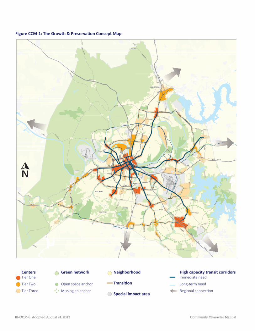
Figure CCM-1: The Growth & Preserva on Concept Map
OAK HILL
FOREST HILLS
GOODLETTSVILLE
BELLE MEADE
BERRY HILL
RIDGETOP
BR
ILEY PKW
Y
ELLI
NG
TON
PK
WY
I40 E
I65 S
I24 W
I24 E
I65 N
I40 W
I440 E
I440 W
I40
I24 E
I65 RAMP
I40 WI6
5 S
I40 E
I24 E
I40
I24 E
I65 N
I65 N
I24 WI6
5 S
I40 W
I24 W
I65
N
I24 E
I65 S
I65
S
I65 N
I40 W
Bell
Rd
Clarksville Pike
Highway 100
Old Hickory Blvd
Whites
CreekPike
Leban
on Pike
Dick
erso
n Pi
ke
Murfreesboro Pike
Hobs
on P
ike
Hillsbo
ro Pi
ke
Franklin Pike
Ashland City Hwy
Galla
tin P
ike
Mccrory Ln
Charlotte Pike
Harding Pl
Don
elso
nP i
ke
Elm Hill Pike
Burkitt Rd
Charlotte Ave
Highway 70
Antioch Pike
Central Pike
Highway 70 S
Woodmont Blvd
Gran
nyW
hite
Pike
Mya
tt D
r
Smith Springs Rd
Hart Ln
W Trinity Ln
Cane Ridge Rd
Harding Pike
Springfield Hwy
West End Ave
3rd Ave N
12th
Ave
S
Jefferson St
Tulip
Gro
ve R
d
State Rt 45
Church St
2nd Ave S
BlueHole
Rd
Battery Ln
Nolensville Pike
OldHa
rd
ing Pike
Broadway
Neelys Bend Rd21
st A
ve S
Haywood Ln
Edm
onds
onPi
ke
Chandler Rd
Shute Ln
Rosa
L Parks Blvd
Mccall St
M t ViewRd
4th Ave S
Couchville Pike
Una Antioch
Pi ke
Fess
lers
Ln
Robin son Rd
Powell Ave
N1s
t St
Wedgewood Ave
5th Ave N
White
B ridge Pike
Galla
tin A
ve
Stewarts Ferry Pike
Murphy RdU
shy 431
Sidc
o Dr
Cockrill Bend Blvd
E T hom
pson
Ln
RivergatePkw
y
E Trinity Ln
County Hospital Rd
High
way
31
Ol dFr
anklinRd
EdTe
mpl
eBl
vd
8th Ave S2nd Ave N
Centennial Blvd
Ushy 41
46th
Ave
N
Due West Ave
Hickory H ollow Pkwy
N M
ain St
17th
Ave
S
Confe renceDr
Crossings B lvd
Division StM
cgav
ock
Pike
Polk Ave
Union St
Highway 96
Pegram Ave
Thompson Ln
Hamilton Church Rd
St Hwy 12
Saundersville Rd
Dr Walt
er S Davis Blvd
Long Hollow Pik
TwoRivers Pkwy
31st Ave S
Walsh Rd
Fairc
loth
Ln
Andr
ewJa
ckso
nPk
wy
28th Ave N
Buena Vista Pike
Main St
Old Hickory Blvd
Edmondson Pike
NolensvillePike
Gran
ny W
hite
Pik
e
Elm Hill Pike
Old Hickory BlvdNolensville Pike
Old
HickoryBlvd
Old H
ickory Blvd
Highway 70 S Harding Pl
Main St
Old Hickory Blvd
Thompson Ln
Charlotte
Pike
Old Hickory BlvdOld Hickory Blvd
I666
←
N
CentersTier One
Tier Two
Tier Three
Green network
Open space anchor
Missing an anchor
Neighborhood
Transi on
Special impact area
High capacity transit corridorsImmediate need
Long-term need
Regional connec on
III-CCM-8 Adopted August 24, 2017 Community Character Manual
Growth, Preservation, and Character
Th e Growth & Preservation Concept Map (Concept Map) refl ects Nashvillians’ desires for how Nashville should grow in the future and what should be preserved from change. As shown in Figure CCM-1, the Concept Map identifi es a green network, centers, neighborhoods, transition areas, special impact areas, and high capacity transit networks.
Th e green network that provides access to nature, requires environmental protection, and preserves natural resources. It also identifi es and preserves the physical character of rural, suburban, and urban areas.
Activity centers, identifi ed as Tier 1, Tier 2 and Tier 3, accommodate most future growth, improve public spaces, support transit, provide walkable areas close to most parts of the county, off er new housing choices, and sustain economic activity. While these centers generally match centers and mixed use areas identifi ed in prior Community Plans, in some cases, the Concept Map promotes more intense centers than previously identifi ed. Th is vision encourages infi ll along transit and multimodal corridors in between and immediately around activity and employment centers.Th e Concept Map also represents the High Capacity Transit Corridors identifi ed by nMotion where transit routes are identifi ed for running outside of traffi c.
While complementary, the Concept Map and the Community Plans serve unique roles. Th e Concept Map outlines the vision for Nashville/Davidson County’s growth and guides decisions over a 25 years horizon. Meanwhile, Community Plans guide shorter planning horizons of only fi ve to 10 years, explain each community’s role in that vision, and apply Community Character Policies to implement that vision through land use decisions such as zone changes and subdivision requests. Th e Community Character Policies are defi ned in this manual. Due to their shorter planning horizon, Community Plans need not incorporate all growth forecast through 2040. Instead, Community Plan updates provide better guidance for development as it plays out in the coming decades.
Community Character Manual Adopted August 24, 2017 III-CCM-9
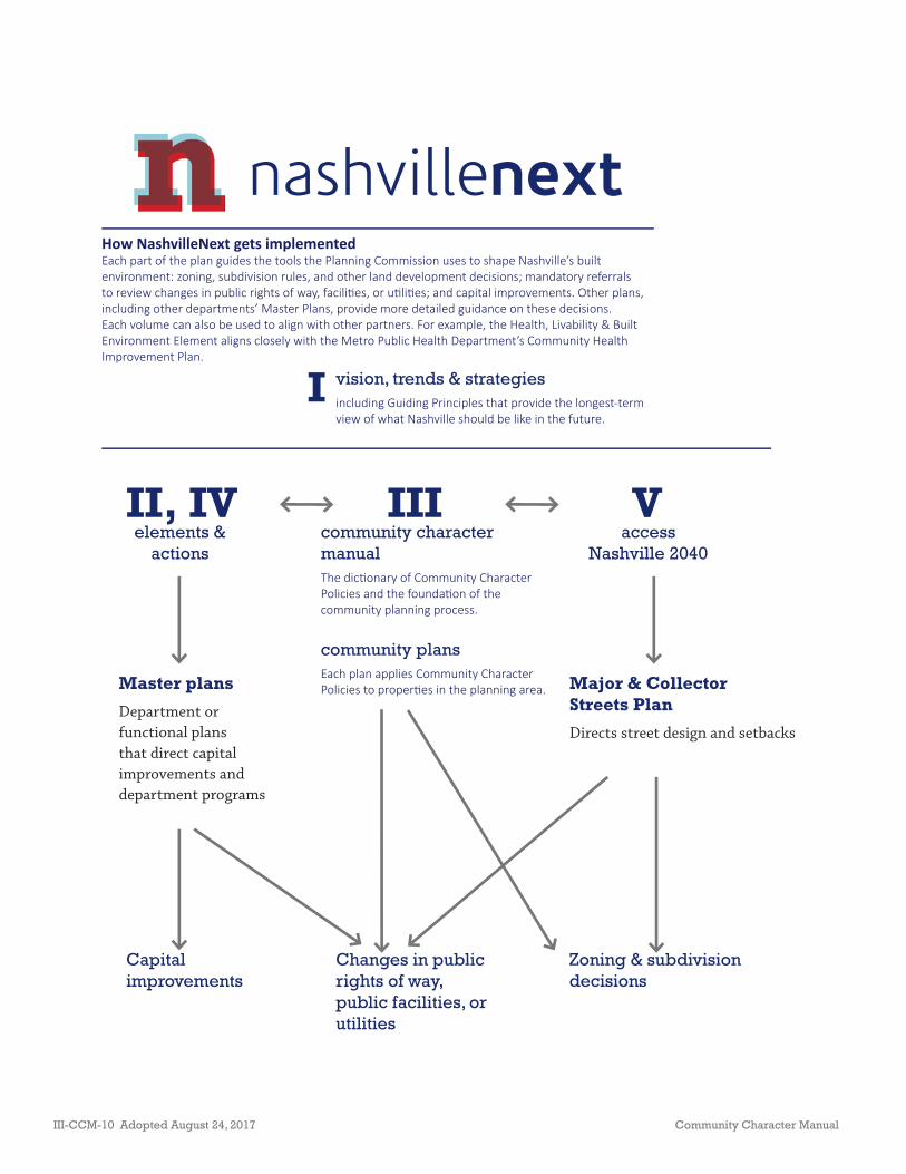
nashvillenext
II, IV III Velements &
actionscommunity character manualThe dic onary of Community Character Policies and the founda on of the community planning process.
community plansEach plan applies Community Character Policies to proper es in the planning area.
access Nashville 2040
Master plans
Department or functional plans that direct capital improvements and department programs
Major & Collector Streets Plan
Directs street design and setbacks
Zoning & subdivision decisions
Capital improvements
Changes in public rights of way, public facilities, or utilities
How NashvilleNext gets implementedEach part of the plan guides the tools the Planning Commission uses to shape Nashville’s built environment: zoning, subdivision rules, and other land development decisions; mandatory referrals to review changes in public rights of way, facili es, or u li es; and capital improvements. Other plans, including other departments’ Master Plans, provide more detailed guidance on these decisions. Each volume can also be used to align with other partners. For example, the Health, Livability & Built Environment Element aligns closely with the Metro Public Health Department’s Community Health Improvement Plan.
I vision, trends & strategiesincluding Guiding Principles that provide the longest-term view of what Nashville should be like in the future.
III-CCM-10 Adopted August 24, 2017 Community Character Manual

Community Planning
Th e Planning Commission and its staff at the Planning Department conduct community planning in Davidson County’s 14 communities. Staff prepares a Community Plan for each community that is updated periodically through a process that engages community stakeholders — residents, property owners, business owners, institutional representatives, developers, and elected offi cials — in planning for future growth, development, and preservation in the community.
Th e Planning Commission adopts Community Plans following a process conducted by the Planning Department staff that includes several community meetings and a public hearing. Th e Planning Commission may also amend the Community Plans following a process that includes a public hearing and may also involve one or more community meetings prior to the public hearing. All 14 Community Plans were amended to align with the Growth & Preservation Concept Map with adoption of NashvilleNext in 2015. Th is process included three review workshops held in March 2013; an online map of the prior and proposed policies was also available for review. Th e revised map was adopted by Planning Commission in June of that year. Subsequent refi nements to the map during the development of NashvilleNext’s Growth & Preservation Concept Map were reviewed at public meetings and online from October 2014 through January 2015. Th e Planning Commission adopted an update to NashvilleNext in 2017 that included reformatting of all 14 Community Plans.
DowntownDowntown
Green Hills -Green Hills -MidtownMidtown
An och - An och - Priest LakePriest Lake
SoutheastSoutheast
SouthSouthNashvilleNashville
Donelson-Donelson-Hermitage-Hermitage-Old HickoryOld Hickory
MadisonMadison
EastEastNashvilleNashville
WestWestNashvilleNashville
NorthNorthNashvilleNashville
BellevueBellevue
Bordeaux - Bordeaux - Whites CreekWhites Creek
Parkwood - Parkwood - Union HillUnion HillJoeltonJoelton
Figure CCM-2: Nashville’s 14 community planning areas
Community Character Manual Adopted August 24, 2017 III-CCM-11
Use of the Community Plans
Th e 14 Community Plans are used together with the Community Character Manual to make decisions on a daily basis. Key decisions guided by the community plans include:
• Public and private investment decisions about where to build infrastructure and buildings;
• Planning Commission’s recommendations and Metro Council’s actions on zone change proposals;
• Planning Commission’s actions on subdivisions;
• Planning Commission’s decisions on surplus properties; and
• Planning Commission’s recommendations to Metro Council for the city’s annual Capital Improvements Budget (CIB) and Capital Spending Plan (CSP). Th e CIB allocates money for public facilities such as roads or public buildings. Th e CSP is the Mayor’s recommended list of the projects in the CIB that should be funded in a given year. Both must be approved by Metro Council.
Although there are some instances when the recommendations in the Community Plans are not followed all the way through to the fi nal actions of Council or other Metro government entities, they have established an outstanding track record over the 25 years of their existence. Government decision makers understand that substantial community participation from a broad range of stakeholders and signifi cant professional analysis went into creating them.
III-CCM-12 Adopted August 24, 2017 Community Character Manual

Organization of the Community Plans
Each of the 14 Community Plans is made up of text and mapped information. Th e text for each community plan area is in two places: the Community Plan, which applies Community Character Policies to each property, and the Community Character Manual, which defi nes the Community Character Policies.
Each community plan document is organized as follows:
• Community Profi le
• History Highlights
• Role in the County and Region
• Growth & Preservation Concept Map and the Community’s Role
• Th e Transect
• Community Character Policy Map
• Supplemental Policies
• Enhancements to the Open Space Network
• Enhancements to the Transportation Network
Th e Community Character Policy Map is used to determine which Community Character Policy is applied to the area of interest. Th e Community Character Manual describes in detail the characteristics for the application of each policy.
Some areas need more detailed guidance than what is included in the CCM. Th e Community Plan provides this guidance through Supplemental Policy Areas, although they are used sparingly. Th e Supplemental Policies may provide additional specifi city to the broad language in CCM or they may describe conditions that deviate slightly from the CCM policy. In all cases, users should fi rst refer to the separate CCM document to understand the policy’s general intent, application, characteristics, and design principles, then look at the specifi c Community Plan for any Supplemental Policies.
Online Community Character MapsThe community plans and CCM can be used with an interac ve online mapping tool that shows where the diff erent Community Character policy areas are located. The mapping tool is at
h p://www.nashville.gov/Planning-Department/Community-Planning-Design/Our-Communi es.aspx
If you are unable to access the interac ve map, you may request help to determine the policies for your area of interest by calling 615-862-7190.
Community Character Manual Adopted August 24, 2017 III-CCM-13

Community Plans are policy documents. While not regulatory, like zoning, they are used as the basis for guiding some regulations, such as rezoning or subdivision of property. Community Plans do not alter the existing zoning on properties or initiate the taking of property. Th ey are used to guide Planning Department staff recommendations to the Planning Commission and Metro Council when future zoning decisions are made. Zoning decisions determine land uses and densities/intensities of the property.
When a property owner fi les a zone change application, the Planning Department staff refers to the Community Plan to make its recommendation on whether the Planning Commission and Metro Council should support or reject the zone change request. In the Subdivision Regulations, Community Plan policy is used for determining which set of rules apply to a particular property. For example, in areas designated Neighborhood Maintenance by the Community Plan, the Subdivision Regulations apply standards to require compatibility of new lots with the surrounding parcels.
Th e Community Plan can set the stage for individual property owners or groups of owners to change their zoning to fully realize the future vision. Th e Community Plan is the fi rst step toward developing an Urban Design Overlay, to rezone an area to a Specifi c Plan District, or to initate any other rezoning.
III-CCM-14 Adopted August 24, 2017 Community Character Manual

History of Community Planning in NashvilleNashville’s community planning program began in 1989. The program came out of the 1988 Growth Management Study done for the Planning Commission. At that me, Nashville had a single-document General Plan, adopted in 1980. Nashville/Davidson County began planning for 14 planning communi es. Ini ally, numbers were used instead of names because each community has many unique neighborhoods and commercial areas. The fi rst plan was for the Donelson-Hermitage-Old Hickory Community, then known as “Subarea 14.” The numbers were replaced with names in 2000.
• An och-Priest Lake (Subarea 13): Feb. 28, 1991; Oct. 17, 1996; Oct. 25, 2012
• Bellevue (Subarea 6): Aug. 16, 1990; Aug. 8, 1996; Feb. 13, 2003; Jan. 26, 2012
• Bordeaux-Whites Creek (Subarea 3): Aug. 13, 1992; Apr. 16, 1998; Sept. 25, 2003
• Donelson-Hermitage-Old Hickory (Subarea 14): Jan. 18, 1990; March 7, 1996; Oct. 14, 2004
• Downtown (Subarea 9): Dec. 9, 1991; Nov. 26, 1997; Feb. 22, 2007
• East Nashville (Subarea 5): Nov. 17, 1994; Feb. 9, 2006
• Green Hills-Midtown (Subarea 10): Dec. 15, 1994; July 28, 2005
• Joelton (Subarea 1): July 16, 1992; Dec. 11, 1997; Oct. 9, 2003
• Madison (Subarea 4): March 25, 1993; part July 23, 1998, remainder Oct. 29, 1998; Apr. 14, 2009
• North Nashville (Subarea 8): Part on May 5, 1994 and remainder on Aug. 11, 1994; Jan. 24, 2002; Jan. 27, 2011
• Parkwood-Union Hill (Subarea 2): June 29, 1995; Sept. 28, 2006
• South Nashville (Subarea 11): June 3, 1993; April 15, 1999; Dec. 13, 2007
• Southeast (Subarea 12): April 11, 1991; April 3, 1997; July 22, 2004
• West Nashville (Subarea 7): Jan. 14, 1994; Jan. 28, 2000; July 23, 2009
The Planning Commission updated the 1980 General Plan in the early 1990s. The new General Plan was called Concept 2010: A General Plan for Nashville and Davidson County. It was adopted by the Commission on Feb. 19, 1992. The exis ng subarea plans were adopted as components of the new General Plan.
The 14 community plans were created with the help of stakeholders from each community. They included residents, property owners, business owners, ins tu onal leaders, development professionals,
and government offi cials. These stakeholders worked together with the Planning Department staff . It took several months of community mee ngs and staff work to create each plan.
The community plans are dynamic documents that are updated periodically and amended as needed in between plan updates. The fi rst round of community plan updates used a process that varied in complexity with the level of change that needed to be made to the plan. Planning Department staff conducted an analysis of the level of change that had taken place in each community since its plan was originally adopted and the impacts of change on the plan’s direc on. Staff then recommended to the Planning Commission whether a plan update should be a Level 1, 2, or 3 update. A Level 1 update was for plans where li le change was needed. Level 1 updates generally consisted of one or two open workshop-style mee ngs. A Level 2 update involved moderately complex plan updates and a larger number of mee ngs. A Level 3 update was for communi es where the level of changes needed was expected to be extensive and involved the use of an appointed Community Advisory Commi ee mee ng over a period of several months.
Prior to NashvilleNext, the most recent round of community plan updates involved a series of open workshop-style public mee ngs that took place over a period of several months. The series of public mee ngs included a kick-off open house, visioning exercises, policy workshops, and dra plan reviews. The newest community plan updates also used a new countywide policy manual called the Community Character Manual (CCM). The CCM provided more detailed policy guidance than its predecessor manual, Land Use Policy Applica on.
The adop on and use of the CCM represents the evolu on in the community’s understanding of community planning. The Land Use Policy Applica on was created in 1992 and focused primarily on land use and density. Over me, the community’s understanding of desirable development has come to put more emphasis on the form or character of development—massing, orienta on and scale of buildings, setbacks and spacing, loca on of access and parking, etc. Meanwhile, the community’s commitment to preserving Nashville/Davidson County’s diversity of development in rural, suburban, and urban areas has grown. The Land Use Policy Applica on did not provide adequate guidance on how to preserve or create community character through form, nor did it create signifi cant dis nc ons between rural, suburban, or urban development. The result has been development that is homogeneous and does not preserve or create the sense of place that community members o en call for during Community Planning.
Community Character Manual Adopted August 24, 2017 III-CCM-15

PAGE LEFT INTENTIONALLY BLANK
III-CCM-16 Adopted August 24, 2017 Community Character Manual

STRUCTURE OF CHARACTER POLICIES
The Community Character Manual (CCM) was originally adopted in 2008 and made part of NashvilleNext in 2015. The CCM:
• Contains the Community Character Policies used in each community plan.
• Provides direc on for implementa on tools such as zoning.
• Helps shape the character Nashville’s unique communi es.
Th e Community Character Mamual (CCM) is built around identifying the future character of an area, compared with its current character. Development character includes design elements like building size and height, setbacks from the street, and spacing. It also includes things like access, parking, and landscaping. Community Character Policies consider three diff erent aspects of character to shape the future character of an area. Th e overarching concept behind each Community Character Policy is its location in the Transect—T1 Natural, T2 Rural, T3 Suburban, T4 Urban, T5 Center, T6 Downtown, and D District. Th e structure of the Community Character Policies and the CCM is explained in detail below.
Transect - Th e CCM uses a planning tool called the Transect, which is discussed in more detail below. Th e Transect describes a range of development patterns from most to least developed. Th e Transect model calls for development in the diff erent Transect Categories to be distinctive. Rural development should look and feel diff erent from suburban or urban development. Th e Community Character Policies support the many development patterns across Davidson County.
Community Elements - Th e Community Character Policies provide guidance for four Community Elements within each Transect Category: Open Space, Neighborhoods, Centers, and Corridors. Th ere is more detailed information about the Community Elements below.
Policy Intent - Th is shows how an area’s future character relates to its current character. Where the current character is set, policies can recommend the character be preserved or enhanced. Where the future character diff ers from current character, the policy intent is to create the new character.
Community Character Manual Adopted August 24, 2017 III-CCM-17

The Transect
Organizing community character
Th e Transect is a system for categorizing, understanding, and guiding the various development patterns of a region, from the most natural and rural to the most urban. Th e Transect is an ordering system, which calls for consistency among all elements of the natural and built environment with the character of the Transect Category that they are within.
Th e Nashville/Davidson County Transect consists of seven categories of natural and built environments:
• T1 Natural • T2 Rural• T3 Suburban• T4 Urban• T5 Center • T6 Downtown• D District
See Figure CCM-3 for an illustration of how the Transect defi nes the character of diff erent areas.
Each Transect Category diff ers from the others in terms of its pattern of development and form or character of development. For example, T2 Rural neighborhoods have primarily single-family and two-family houses spaced far apart with irregular setbacks, with driveway access off narrower rural roads lined with ditches and swales. Meanwhile, T4 Urban neighborhoods have single-family, two-family, and multifamily buildings, spaced more closely together with consistent, regular setbacks, with alley access along streets with curbs, gutters, and sidewalks.
Development within each Transect Category should have distinct form, character, uses, and density/intensity. For example, alley access would be inconsistent in the T2 Rural area just as a rural road with ditch and swale would be out of place in a T4 Urban area.
T1
T2
T3
T4
T5
T6
Figure CCM-3: The Transect, Illustrated
III-CCM-18 Adopted August 24, 2017 Community Character Manual

Th e Community Character Policies guide decisions on future zone change and subdivision requests to achieve the planning policies and principles of their Transect Categories. For example, the building heights, which are regulated by a site’s zoning district, will be diff erent in a T2 Rural area versus a T3 Suburban area versus the T6 Downtown. Since the Community Character Policies are used to guide future zone change decisions, the policies speak to design issues such as building massing, orientation, and placement, signage, lighting, landscaping, access, and other design elements that create a unifi ed form of development for each Transect Category.
Figure CCM-4 shows a generalized Nashville/Davidson County Transect. Th e Transect categorization for each community is determined during the Community Plan Update. Th e Transect map is, therefore, subject to continuing refi nement with each subsequent Community Plan update.
Community Character Manual Adopted August 24, 2017 III-CCM-19
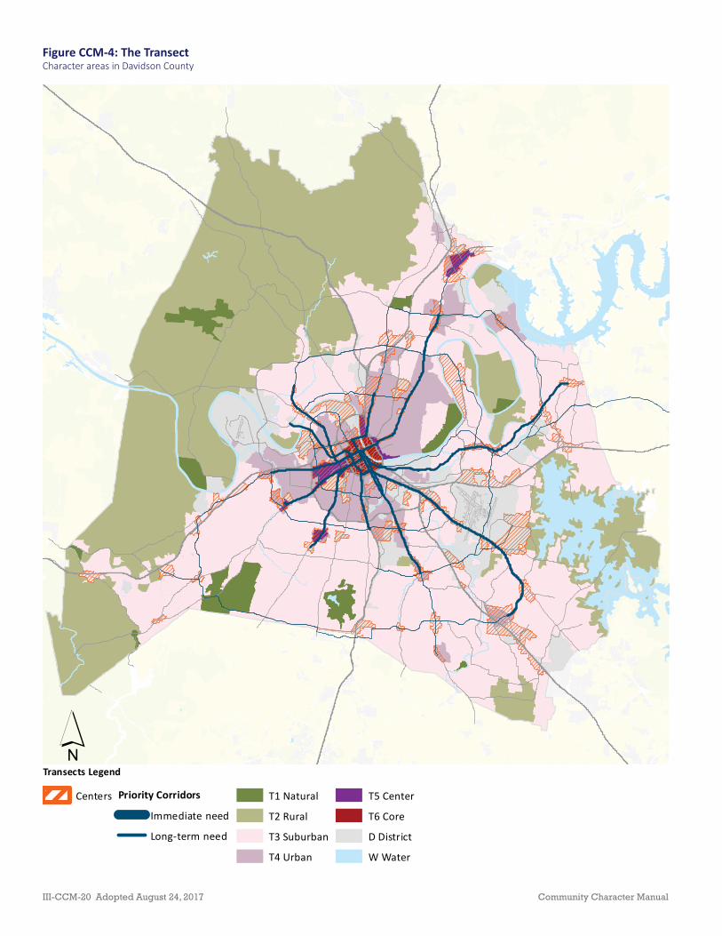
Figure CCM-4: The TransectCharacter areas in Davidson County
Transects Legend
Centers Priority Corridors
Immediate need
Long-term need
T1 Natural
T2 Rural
T3 Suburban
T4 Urban
T5 Center
T6 Core
D District
W Water
´
III-CCM-20 Adopted August 24, 2017 Community Character Manual

Community Elements
Four community elements—Open Space, Neighborhoods, Centers, and Corridors—represent the diff erent kinds of places that may be within each of the developed Transect Categories. Th e scale, character, and intensity of the community element varies depending on its Transect Category in which it is located. Not all community elements are found in each Transect Category. For example, while there are prominent rural roads in Davidson County, there is no Community Character Policy for T2 Rural Corridor. Rather, these roads are incorporated into the “neighborhoods”—extremely low-density residential or rural hamlets—through which they pass.
Open Space
Open space is the least developed Community Element. In many instances, it preserves the natural environment from growth and development. In other instances, open space may develop with low-impact design and techniques may provide recreation opportunities for the community. Open space can take many diff erent forms. In T1 Natural and T2 Rural settings, open space is generally passive, using the natural vegetation as its landscape with few if any additional amenities. In T3 Suburban and T4 Urban settings, open spaces become more formal to accommodate active recreational uses, with passive uses appearing as plazas, courtyards, and squares.
As described in the Plan to Play, open spaces do not exist in isolation, and their design should refl ect the needs and context of the surrounding neighborhood and community. Th e transition between open space and neighborhoods or centers should concentrate on the access to and from for pedestrians, cyclists, and vehicles. Near centers and corridors, open spaces serve as a focal point, that complements the character of higher-intensity land uses found in centers and along corridors.
Community Character Manual Adopted August 24, 2017 III-CCM-21

Neighborhoods
Neighborhoods represent the backbone of the community, providing a home for residents at every stage in the life cycle near corridors, centers, and open space. CCM policies encourage a carefully integrated, well-designed mix of housing that refl ects the character of the existing or envisioned neighborhood. Th is mixture focuses on the form of the buildings to maintain, enhance, or create the intended character.
Centers
Centers represent gathering places situated within neighborhoods or at the edges of adjoining neighborhoods or communities. Centers off er access to retail and services, civic and public benefi t uses such as schools, churches and post offi ces, employment, and residences.
Centers may transition into the surrounding neighborhood and open space components through the presence of slightly higher-density residential development on the edge of the center. Th is transition allows for the presence of residential to support commercial and offi ce land uses within the center, but also creates a natural transition through building type and form instead of through landscaping or buff ering.
III-CCM-22 Adopted August 24, 2017 Community Character Manual

Corridors
Corridors link neighborhoods, communities, and the region together. Th e scale and character of the corridor can vary depending on its use and location in a particular Transect Category. Corridors are defi ned as human-made transportation corridors moving across the Transect, which are intended to be designed and to function diff erently depending on the Transect Category through which they pass.
As corridors pass through Transect Categories from a more natural setting to an urban setting, they are often built to follow the natural topography of the land and serve as throughways, moving people to and from the outer areas of the region into more densely populated urban areas.
Corridors that serve neighborhoods, centers, and open space accommodate the changing community elements (neighborhood, center, open space) they encounter and the changing form and character of the Transect Categories through which they pass. In most cases, corridors accommodate complementary methods of travel with bikeways, sidewalks, and mass transit incorporated into the design of the corridor.
Community Character Manual Adopted August 24, 2017 III-CCM-23

Function of Community Character Policies
Community Character Policies are the primary product of each Community Plan. Community Character Policies are applied to all the property in each community. Th e Community Character Policies contained in this document have two main functions:
• To explain the vision of the community for its future growth, development, and preservation and
• To provide direction for implementation tools such as zoning. Future zone change requests in any given community are judged for their conformance with the Community Character Policies in the Community Plan. Subdivision request decisions are also guided by Community Character Policy.
Th e Community Character Policies establish the appropriate form and character of development — massing, orientation and scale of buildings, setbacks and spacing, location of access and parking, etc. Th e emphasis on form and character allows communities to preserve existing character and enhance or create areas with distinctive rural, suburban, urban, or district character. For example, a suburban neighborhood Community Character Policy will have a diff erent form of development than an urban Community Character Policy or a Downtown neighborhood policy.
In some areas, Detailed Design Plans may be developed for a specifi c neighborhood, center, or corridor to further refi ne the guidance provided by the Community Plan. Th e process of developing a Detailed Design Plan involves substantial community participation in workshops and meetings.
III-CCM-24 Adopted August 24, 2017 Community Character Manual

Language in the CCMThe CCM includes a glossary (see Appendix, page 454) that defi nes many terms used in the document. One addi onal explana on on language is necessary. Given that the Community Character Policies are not regulatory, the descrip ons in each policy do not use verbs such as “shall.” Instead, the policies and their guidelines are wri en with ac ve verbs where “shall” or “should” is replaced with “is.” This use of terminology is intended to indicate that the policies describe the Community Element—the open space, neighborhood, center, or corridor—as it is envisioned to be developed or redeveloped. The guidelines remain the standards to which proposed development should strive and the standards against which proposed development will be measured.
Photographs in CCMThroughout the Community Character Manual, photographs are included to show illustra ve examples of building and site design elements in a context that is intended to refl ect the form of the item and the Transect Category in which the item is found. The photographs are not intended to refl ect architectural or aesthe c preferences as those are not governed by the Community Character Manual. However, the photographs are also not intended to limit innova on in architecture or in the crea on of innova ve site and building design.
Intent of Community Character Policies
Each Community Character Policy has a stated intent — to maintain, to enhance, or to create. Th is acknowledges the diversity of development, redevelopment, and preservation needs present throughout Nashville/Davidson County.
A healthy neighborhood in the T3 Transect Category that needs to be maintained with little change is a candidate for the T3 Neighborhood Maintenance (T3-NM) Community Character Policy since the intent is to maintain the neighborhood. Meanwhile, another neighborhood may be facing redevelopment pressures due to outdated housing stock, proximity to centers, or unsustainable features such as lack of connectivity. T3 Neighborhood Evolving (T3-NE) policy, with the intent of enhancing the area, would be applied to this neighborhood to encourage appropriate infi ll and redevelopment.
Alternatively, few centers in Davidson County currently meet their full potential as areas to live, work, and play. In center policies across all Transect Categories, therefore, the intent is to create and enhance centers to serve the surrounding neighborhoods and communities.
Policy intent also suggests appropriate scale intended for each center. A center may be planned to serve a neighborhood, community, or the region. Similarly, corridors may be intended to serve as mixed use or residential only.
Community Character Manual Adopted August 24, 2017 III-CCM-25
Organization of of the Community Character Policies
In addition to detailed descriptions of the Community Character Policies, the CCM also identifi es appropriate zoning districts, building types, and design principles for each Community Character Policy. Th e Community Character Policies and related information should be used in the development of site plans, development scenarios, and neighborhood, center, corridor, and community planning eff orts.
Th e CCM provides information that enables residents, business owners, property owners, institutional representatives, developers, and elected offi cials to take a proactive role in the community planning process to preserve the diversity of development that is a hallmark of Nashville/Davidson County and create sustainable development for the future.
Within each Community Element are Community Character Policies that describe the form and character, land uses, and densities of development specifi c to that Community Element within that Transect Category.
Each Community Character Policy provides guidance pertaining to the following:
• Policy Intent: describes the policy’s intent to maintain, enhance, and/or create the desired character of the Community Character Policy;
• General Characteristics: summarizes the existing and desired traits of development within the policy;
• Application: outlines the situations in which the policy is applied and descriptions of where use of this policy is appropriate;
• Design Principles: describes the form and character of the policy, including building form and site design, transitioning, and connectivity; and
• Zoning Districts: lists zoning districts suitable for each Community Character Policy. Th ese zoning districts generally refl ect the density/intensity envisioned, but in many cases a higher level of urban design—achieved through the use of design-based zoning—is appropriate.
III-CCM-26 Adopted August 24, 2017 Community Character Manual

Figure CCM-5: T4 Urban Flow Chart
Transect Elements Policy
T4
Intent
Neighborhoods
Centers
Corridors
T4 Urban Neighborhood Maintenance
T4 Urban Neighborhood Evolving
T4 Urban Mixed-Use Neighborhood
Create & ,
T4 Urban Neighborhood Center
T4 Urban Community Center
Enhance
T4 Urban Residential Corridor
T4 Urban Mixed-Use Corridor
,
Create &
,
Diagrams in the CCM
Each Transect Category introduction includes “fl ow chart” and “fi gure ground” diagrams. Th e “fl ow chart” diagram presents the following, from left to right: Transect Category, Community Elements present, Community Character Policies available for each Community Element, and the intent of policy. Figure CCM-5 presents an example of the Th e “fl ow chart” diagram. Th e “fi gure ground” diagrams show open space, building footprints, and street and block patterns. Open space is displayed in the fi gure-ground in green. Neighborhoods and Centers are emphasized by displaying areas showing building footprints in black, streets in white, and remaining land in gray. Corridors are displayed in a similar manner, with the general boundaries of the corridor outlined in red to show the prominence of the corridor and its relationship to surrounding Neighborhoods and Centers.
Community Character Manual Adopted August 24, 2017 III-CCM-27
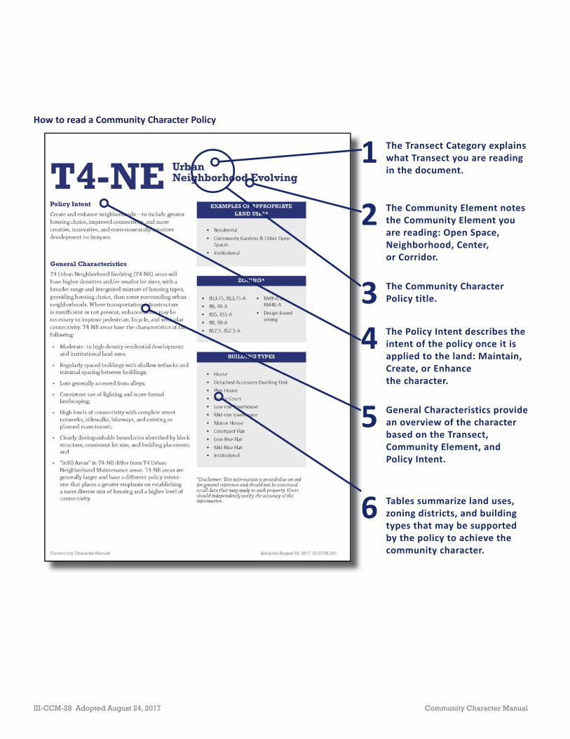
How to read a Community Character Policy
1 The Transect Category explains what Transect you are reading in the document.
2 The Community Element notes the Community Element you are reading: Open Space, Neighborhood, Center, or Corridor.
3 The Community Character Policy title.
4 The Policy Intent describes the intent of the policy once it is applied to the land: Maintain, Create, or Enhance the character.
5 General Characteristics provide an overview of the character based on the Transect, Community Element, and Policy Intent.
6 Tables summarize land uses, zoning districts, and building types that may be supported by the policy to achieve the community character.
III-CCM-28 Adopted August 24, 2017 Community Character Manual

7 Application describes which features should be present in order to apply the Community Character Policy to a property.
8 Design Principles describe the character and form to be achieved through building form and site design, transitioning, and connectivity.
9 Balancing Conservation and Evolving policies describe the way in which development is grouped to preserve sensitive features and implement the Design Principles.
Community Character Manual Adopted August 24, 2017 III-CCM-29

Figure-ground diagram of a T2 Rural neighborhood
Figure-ground diagram of a T3 Suburban Figure-ground diagram of a T4 Urban neighborhood
Illustrations
Figure-ground diagrams
Incorporated into each policy area are fi gure-ground diagrams that give a bird’s-eye view of an area to show the relationships between buildings (fi gure) and parcels, streets, blocks, and open spaces (ground). Th ese show how built structures relate to one another and streetscapes.
III-CCM-30 Adopted August 24, 2017 Community Character Manual

Building Type Descrip ons
Low-Rise Buildings1 – 3 stories
House
A low-rise building type that describes a detached structure suitable for residence by an individual or family. Vehicular access is from the fron ng street, side street, or alley. A primary pedestrian entrance is located along the primary street frontage of the building.
Detached Accessory Dwelling Unit (DADU)
A low-rise building type that describes a detached living structure this is subordinate to the main dwelling or use of land and located on the same lot and under the same ownership. Vehicular access is from the fron ng street or alley, and a pedestrian passage way is provided to the street frontage. Alterna ve names for this building type include: granny fl at, mother-in-law suite, garage apartment, carriage house, and alley house.
Plex House
A low-rise building type that describes a single structure containing two or more dwelling units. Each unit has its own pedestrian entry, or shares a common entry, along the street frontage. Vehicular access is from the fron ng street, side street, or alley. Common examples of this building type include duplex, triplex, and quadplex.
Building Type Diagrams
Th ese diagrams are generalized representations of commonly used building types and are not intended to refl ect architecture or building materials. Each Community Character Policy area makes references to these building types in terms of appropriate building type and form for achieving the intended character of an area. Th e building types are organized by height and are illustrated below.
Community Character Manual Adopted August 24, 2017 III-CCM-31

House Court
A low-rise building type that describes a group of small detached houses arranged around a common court, yard, or open space that is typically perpendicular to the street. Front façades and primary pedestrian entrances are oriented to and accessed from the common area; houses on the primary street are oriented to the primary street and accessed from the primary street or open space. Vehicular access is from the fron ng street or alley.
Townhouse
A low-rise building type that describes an a ached structure consis ng of two or more single-family dwelling units placed side-by-side. It occupies the full frontage of its lot, elimina ng most side yards. Vehicular access is from the fron ng street or alley and a primary pedestrian entrance for each unit is located along the primary street frontage.
Manor House
A low-rise mul family building type containing between three and six dwelling units. It is designed to appear, from the exterior, as a single-family home with one primary entrance from the exterior and access to the individual living units provided inside the structure. Vehicular access is from the fron ng street, side street, or alley, and a primary pedestrian entrance is located along the primary street frontage of the building.
Courtyard Flat
A low-rise mul family building type in a U- or L-shape that frames a common open space. Pedestrian entrances are located along the primary street frontage and along the open space. Each unit may have its own entry, or up to four units may share a common entry. Vehicular access is from the fron ng street, side street, or alley.
Low-Rise Flat
A small mul family residen al building type which has units arranged along a corridor or around a shared entry. A primary pedestrian entrance is provided along the primary street frontage. Vehicular access is from the fron ng street, side street, or alley.
III-CCM-32 Adopted August 24, 2017 Community Character Manual

Low-Rise Mixed Use
A building type that describes a small structure which may provide a mix of commercial, offi ce and/or residen al uses, with the non-residen al use on the ground fl oor. The building occupies the full frontage of its lot, elimina ng most side yards except for instances of public pedestrian passages from the rear of the lot, or parking areas located to the side of the building. Vehicular access is generally from an alley or side street, and a primary pedestrian entrance is located along the primary street frontage of the building.
Low-Rise Commercial
A building type that describes a structure suitable for non-residen al use. The building occupies the full frontage of its lot, elimina ng most side yards except for instances of public pedestrian passages from the rear of the lot, or parking areas located to the side of the building. Vehicular access is generally from an alley or side street, and a primary pedestrian entrance is located along the primary street frontage of the building.
Community Character Manual Adopted August 24, 2017 III-CCM-33

Mid-Rise Buildings4 – 7 stories
Mid-Rise Townhouse
A mid-rise building type, generally no taller than four stories, that describes an a ached structure consis ng of two or more single-family dwelling units placed side-by-side. It occupies the full frontage of its lot, elimina ng most side yards. Vehicular access is from the fron ng street or alley and a primary pedestrian entrance for each unit is located along the primary street frontage.
Mid-Rise Flat
A four to seven story mul family residen al building type which has one or more shared entries. The building occupies the full frontage of its lot, elimina ng most side yards except for instances of public pedestrian passages from the rear of the lot, or parking areas located to the side of the building. Vehicular access is generally from an alley or side street, and a primary pedestrian entrance is located along the primary street frontage of the building.
Mid-Rise Mixed Use
A building type that describes a four to seven story structure which may provide a mix of commercial, offi ce, and/or residen al uses, with the non-residen al use on the ground fl oor. The building occupies the full frontage of its lot, elimina ng most side yards except for instances of public pedestrian passages from the rear of the lot, or parking areas located to the side of the building. Vehicular access is generally from an alley or side street, and a primary pedestrian entrance is located along the primary street frontage of the building.
III-CCM-34 Adopted August 24, 2017 Community Character Manual

Hi-Rise Buildingsabove 8 stories
High-Rise
A building type that describes a structure with eight or more stories which may be single-use or provide a mix of commercial, offi ce, and/or residen al uses, with the non-residen al use on the ground fl oor. The building occupies the full frontage of its lot, elimina ng most side yards except for instances of public pedestrian passages from the rear of the lot, or parking areas located to the side of the building. Vehicular access is generally from an alley or side street, and a primary pedestrian entrance is located along the primary street frontage of the building.
Stepped High-Rise
A building type that describes a structure with eight or more stories built upon a podium base, above which the building wall steps back from the property line or setback line. The building may be single-use or provide a mix of commercial, offi ce, and/or residen al uses, with the non-residen al use on the ground fl oor. The building occupies the full frontage of its lot, elimina ng most side yards except for instances of public pedestrian passages from the rear of the lot, or parking areas located to the side of the building. Vehicular access is generally from an alley or side street, and a primary pedestrian entrance is located along the primary street frontage of the building.
Community Character Manual Adopted August 24, 2017 III-CCM-35
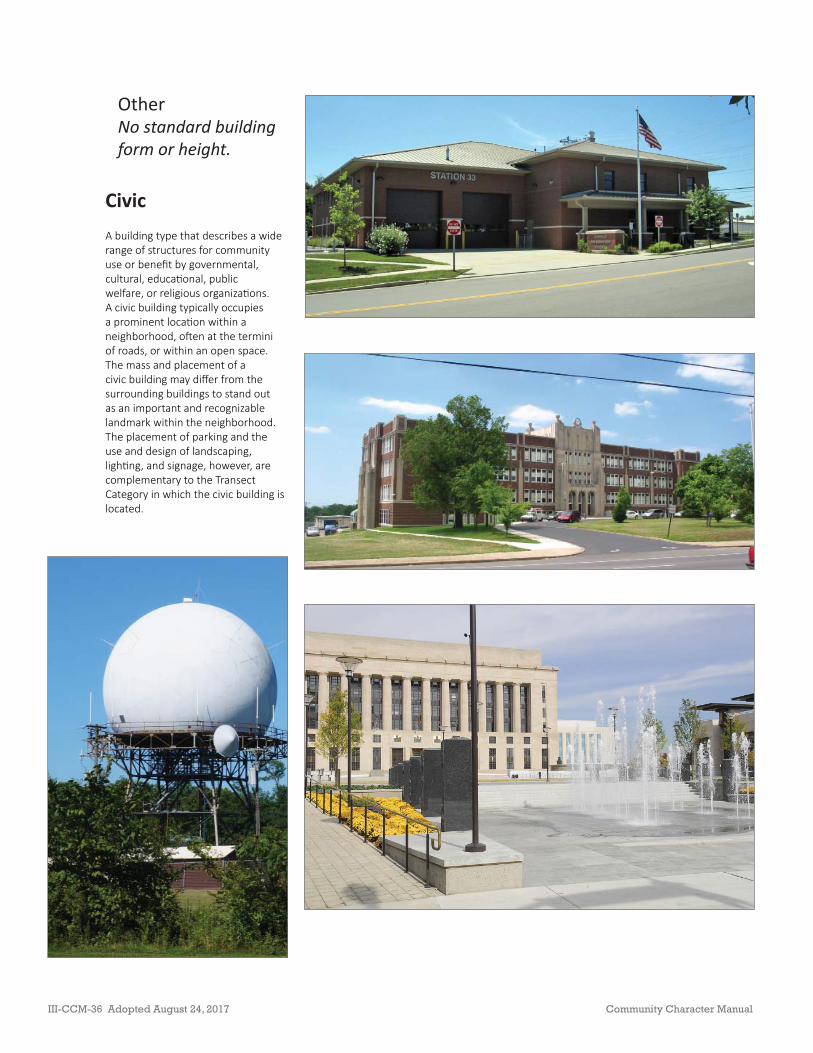
CivicA building type that describes a wide range of structures for community use or benefi t by governmental, cultural, educa onal, public welfare, or religious organiza ons. A civic building typically occupies a prominent loca on within a neighborhood, o en at the termini of roads, or within an open space. The mass and placement of a civic building may diff er from the surrounding buildings to stand out as an important and recognizable landmark within the neighborhood. The placement of parking and the use and design of landscaping, ligh ng, and signage, however, are complementary to the Transect Category in which the civic building is located.
OtherNo standard building form or height.
III-CCM-36 Adopted August 24, 2017 Community Character Manual

AgriculturalA building type that describes a structure intended primarily or exclusively for support of an agricultural func on; examples include but are not limited to barns, silos, water towers, windmills, or greenhouses, and does not include housing or dwelling units.
Community Character Manual Adopted August 24, 2017 III-CCM-37
Transect Policy HouseDetached
Accessory Unit Plex HouseHouse Court
Low-Rise Townhouse Manor House Courtyard Flat
T2 T2 RA
T2 RC
T2 RM
T2 NC
Transect Policy HouseDetached
Accessory Unit Plex HouseHouse Court
Low-Rise Townhouse Manor House Courtyard Flat
T3 T3 NM
T3 NE
T3 NC
T3 CC
T3 RC
T3 CM
Transect Policy HouseDetached
Accessory Unit Plex HouseHouse Court
Low-Rise Townhouse Manor House Courtyard Flat
T4 T4 NM
T4 NE
T4 MU
T4 NC
T4 CC
T4 RC
T4 CM
Transect Policy HouseDetached
Accessory Unit Plex HouseHouse Court
Low-Rise Townhouse Manor House Courtyard Flat
T5 T5 MU
T5 RG
Transect Policy HouseDetached
Accessory Unit Plex HouseHouse Court
Low-Rise Townhouse Manor House Courtyard Flat
T6 T6 DN See Downtown Community Plan
Transect Policy HouseDetached
Accessory Unit Plex HouseHouse Court
Low-Rise Townhouse Manor House Courtyard Flat
D D DR
D EC
D MI
D OC
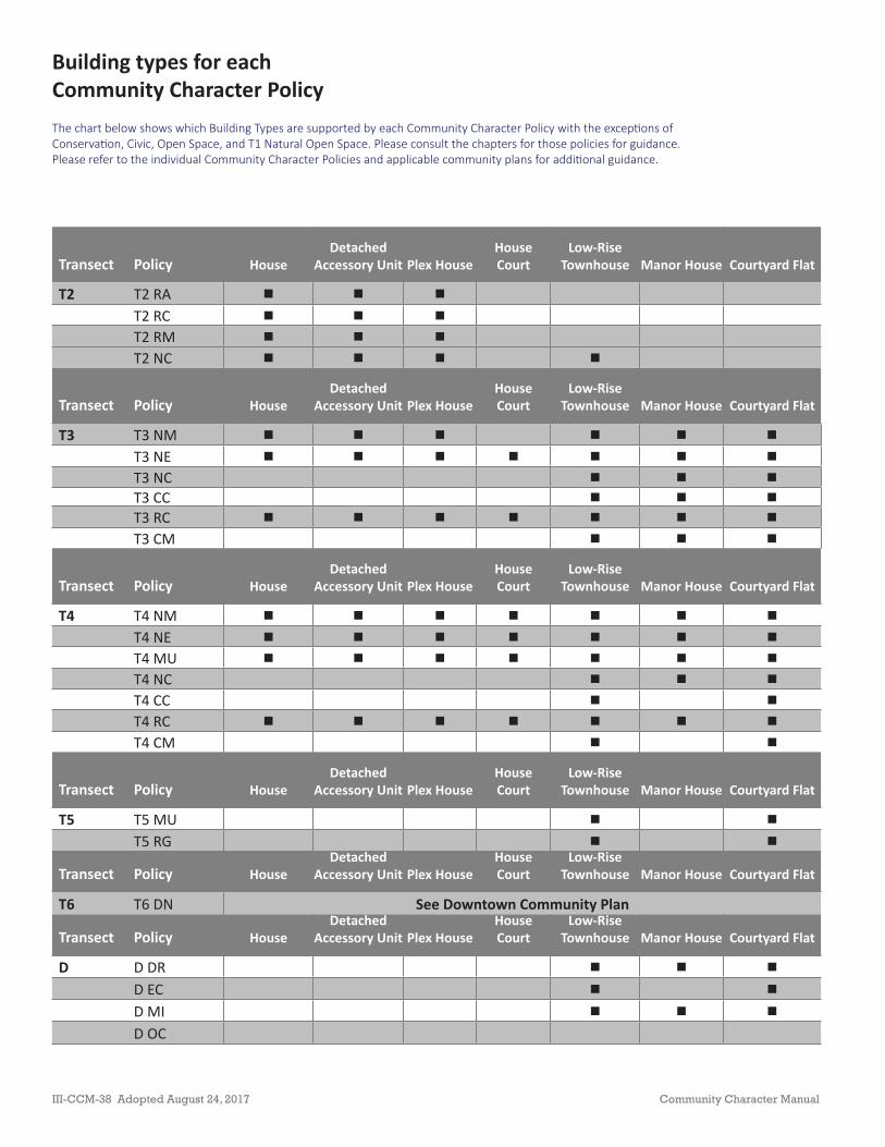
Building types for each Community Character PolicyThe chart below shows which Building Types are supported by each Community Character Policy with the excep ons of Conserva on, Civic, Open Space, and T1 Natural Open Space. Please consult the chapters for those policies for guidance. Please refer to the individual Community Character Policies and applicable community plans for addi onal guidance.
III-CCM-38 Adopted August 24, 2017 Community Character Manual

Transect PolicyLow-Rise
FlatLow-Rise
Mixed UseLow-Rise
CommercialMid-Rise
TownhouseMid-Rise
FlatMid-Rise
Mixed Use High-RiseStepped
High-Rise
T2 T2 RAT2 RCT2 NMT2 NC
Transect PolicyLow-Rise
FlatLow-Rise
Mixed UseLow-Rise
CommercialMid-Rise
TownhouseMid-Rise
FlatMid-Rise
Mixed Use High-RiseStepped
High-Rise
T3 T3 NM
T3 NE
T3 NC
T3 CC
T3 RC
T3 CM
Transect PolicyLow-Rise
FlatLow-Rise
Mixed UseLow-Rise
CommercialMid-Rise
TownhouseMid-Rise
FlatMid-Rise
Mixed Use High-RiseStepped
High-Rise
T4 T4 NM
T4 NE
T4 MU
T4 NC
T4 CC
T4 RC
T4 CM
Transect PolicyLow-Rise
FlatLow-Rise
Mixed UseLow-Rise
CommercialMid-Rise
TownhouseMid-Rise
FlatMid-Rise
Mixed Use High-RiseStepped
High-Rise
T5 T5 MU
T5 RC
Transect PolicyLow-Rise
FlatLow-Rise
Mixed UseLow-Rise
CommercialMid-Rise
TownhouseMid-Rise
FlatMid-Rise
Mixed Use High-RiseStepped
High-Rise
T6 T6 DN See Downtown Community Plan
Transect PolicyLow-Rise
FlatLow-Rise
Mixed UseLow-Rise
CommercialMid-Rise
TownhouseMid-Rise
FlatMid-Rise
Mixed Use High-RiseStepped
High-Rise
D D DR
D EC
D MI
D OC
NotesThe chart does not include the following building types that are referenced in the Community Character Policies because there is too much variety in these types: Agricultural, Civic, and Ins tu onal. Building height ranges used in the Community Character Manual are defi ned in the Glossary in the Appendix. Building height ranges for the T5 Center Transect may vary from the standard height ranges defi ned in the Community Character Manual Glossary found in the Appendix. These varia ons may be established by a Community Plan or Detailed
Design Plan, which should be consulted for addi onal guidance. Building height ranges for the T6 Downtown Transect are defi ned in the Downtown Community Plan and vary from the standard building eight ranges defi ned in the Community Character Manual Glossary (Appendix). Consult the Downtown Community Plan for addi onal guidance.
Community Character Manual Adopted August 24, 2017 III-CCM-39

PAGE LEFT INTENTIONALLY BLANK
III-CCM-40 Adopted August 24, 2017 Community Character Manual

GENERAL PRINCIPLES
Th ese General Principles represent the goals of NashvilleNext as implemented through Community Character Policies in the Community Plans. Unless otherwise noted, they should be considered in conjunction with the particular Community Character Policy applied to a property. Some Policies provide further guidance for these principles.
Engaged Communities
NashvilleNext seeks to create sustainable communities that support a high quality of life. Creating sustainable communities requires plans for future growth and preservation that engage residents, business and property owners, institutions, developers, and elected offi cials in decision-making. Th ese plans seek to balance the economic, environmental, and social needs of the community and the county by encouraging development that is benefi cial to the community today and to future generations. Community planning work with stakeholders to think regionally about the neighborhood’s, the community’s, and the county’s role in the larger Middle Tennessee region.
Th e design of cities, neighborhoods, and individual developments has a long-term impact. Habitats, waterways, and land forms—once developed—are diffi cult, if not impossible, to return to the natural form. Meanwhile, the land use and transportation patterns created through development will impact how people live, work, and play for years. Th ose same land use and transportation patterns will also dictate how the public sector provides services and infrastructure for decades.
Th e NashvilleNext Growth & Preservation Concept Map promotes the goals of preserving rural areas and environmental resources, sustaining the character of neighborhoods, and locating new growth in walkable centers and corridors established by a complete transit network.
Citizens are engaged in planning decisions by shaping long-range plans, including NashvilleNext and its community plans, other detailed plans, and reviewing and discussing development proposals that can implement or change those plans.
Community Character Manual Adopted August 24, 2017 III-CCM-41
Sustainable Development
Sustainable developments consider the impact on the environment, the economy, and the social needs of the community today and in the future. Sustainable development considers a site’s context: land use and land preservation, transportation networks, infrastructure, and community character. By considering all of these elements, developments can improve the environmental, economic, and social health of a community by:
• Reducing sprawl and related Metro expenditures on infrastructure and services
• Managing traffi c and congestion
• Reducing air pollution
• Improving the vitality of commercial and employment centers
• Maintaining the sustainability of food sources
• Improving housing aff ordability
• Preserving natural resources and open space
Land Use and Transportation
Tranpsortation and land use are fundamentally interrelated: a land use decision has a direct impact on the transportation network, and changes to a transportation network will lead to changes in land use. Planners have learned that making land use and transportation decisions in isolation can have impacts that work against long-range plans and frustrate the public.
Growth with intention means growing in a way that intentionlly provides greater intensity to support mass transit along certain corridors. However, the rate and nature of regional growth suggest that such investments could be very eff ective over the long term if undertaken in concert with coordinated changes in land use, development, and complementary public policy and investments over the long-term.
Coordinating land use decisions and infrastructure investments between agencies create meaningful access and choice. Th e individual components of the transportation network should be appropriate for each neighborhood and the users that they serve. Th oughtful decisions about how we grow in the future can impact quality of life, specifi cally one’s income spent on transportation and housing and ease of access to daily needs.
III-CCM-42 Adopted August 24, 2017 Community Character Manual

Healthy & Complete Communities
Th e layout and design of our communities infl uence the physical, mental, and emotional health of the people who live, work, and play in them. Healthy community design improves quality of life by making it easier for people to make healthy choices and live healthier lives.
Th e land use and transportation patterns created through new development and redevelopment will impact the health of our communities for many years. Th e negative health eff ects of sprawling development patterns have taken decades to become evident. Instituting healthy community design is not a quick solution. It can, however, shift development patterns toward built environments that are more supportive of health and provide a foundation for current and future generations to live healthy and productive lives.
Complete communities feature a mix of housing types to meet the needs of community members at all stages of their lives. A complete community’s housing is convenient to daily consumer needs and open space to provide recreational opportunities, and it provides transportation options for vehicles, transit, pedestrians, and bicycles to access workplaces, shops, and services.
Healthy community design helps to address the following public health challenges:
• Improving access to healthy food
• Increasing daily physical activity
• Improving air quality
• Reducing injuries
• Placing daily needs close to homes
• Providing transportation options to access workplaces and services
• Ensuring aff ordability across income levels throughout the county
• Locating undesirable land uses throughtfully and equitably
Community Character Manual Adopted August 24, 2017 III-CCM-43
Distinct Character
Sustainable, healthy communities will not look the same throughout Davidson County. Residents cherish the diff erent kinds of places Nashville off ers to live, work, and play. A rural community will look diff erent than an urban neighborhood. Development should follow the Design Principles contained within each Community Character Policy to maintain, enhance, or create the character of the area. Linking design and development guidelines to the Transect Category preserves the unique diversity of character of development in Nashville/Davidson County.
Efficient Government
How the county is built has a long-term impact on the county’s fi nances, tax base and rates, and the level of services it provides. Managing growth thoughtfully can:
• Take advantage of an increasing tax base in high-demand areas
• Provide services effi ciently through compact urban form
• Reduce the need to increase taxes or fees to build or maintain infrastructure
III-CCM-44 Adopted August 24, 2017 Community Character Manual

STRATEGIES
Housing Choice
Neighborhoods are the fabric of a community, and the housing within a neighborhood—its type, style, design, and historical quality—defi nes the character of a neighborhood. Residents at various stages of life have diff erent housing needs, requiring a diverse mix of housing types in the neighborhood. A diverse housing mix meets the changing housing needs across the lifecycle including rental, fi rst-time ownership housing, “move up” ownership housing, housing for people who wish to downsize, and assisted-type housing for the elderly and people with disabilities.
NashvilleNext calls for the creation of aff ordable housing for low-income individuals and families, the preservation of housing stock, and the creation of new housing and diverse housing types to ensure that there is housing attainable for all Nashvillians.
Th e Community Character Manual aims to ensure that every community has:
• Housing that, regardless of type, user, or income of residents, complements the community character in terms of mass, scale, and orientation and is seamlessly integrated into the neighborhood so that the housing functions as part of the neighborhood rather than as an isolated development;
• A diverse housing mix that meets the needs of a variety of lower, moderate, middle, and upper income households;
• Housing that is thoughtfully mixed so that housing is not segregated by type, by user, or by income;
• Housing that capitalizes on existing transit or provides the opportunity for extension of transit service; and
• Housing that provides access to existing commercial and employment centers or provides the opportunity to create services to meet the daily needs of residents.
While Nashville/Davidson County has various entities and tools that address aff ordable housing, the community planning process can establish the fundamental policies in support of housing diversity by encouraging housing choice in every community throughout the county. Th is does not diminish the need for Metro departments and public/private partnerships to work to provide housing that is attainable to all residents of the county.
Community Character Manual Adopted August 24, 2017 III-CCM-45

Using Community Character Policies to provide a mixture of housing types has a variety of benefi ts. Th ese benefi ts include ensuring that there is room in a neighborhood for all community members, regardless of their stage in life and their housing needs at that moment. Housing choice also helps ensure that residents have options in multiple communities where housing is near commercial and employment centers, multiple transportation options, and civic and public benefi t services.
Revitalization, Gentrification, and Deterioration of Neighborhoods
Th e community planning process engages all stakeholders in planning for future growth, development, and preservation. Th e Community Plan is intended to guide future development. It is used to revitalize neighborhoods, corridors, or communities that have deteriorated. It is also used to guide revitalization that is already underway. Often, future development evokes change in community character—changes in the built environment as well as the demographic composition of the neighborhood or community. Th is guiding principle addresses community planning’s role in revitalization, gentrifi cation, and working to halt deterioration of neighborhoods.
Change in neighborhoods over time is a given. Some neighborhoods face more dramatic change with the threat of deterioration or, conversely, with revitalization or gentrifi cation. Deterioration, through the exodus of neighbors or the decline of properties, is relatively easy to label.
Revitalization eff orts in a neighborhood are diff erent from gentrifi cation, although the two may be mistaken for one another. Revitalization is the process of enhancing the physical, commercial, and social components of the neighborhood through private- and/or public-sector eff orts. Gentrifi cation is the process by which higher-income households displace lower-income households in a neighborhood, changing the essential character of that neighborhood. While gentrifi cation may occur during revitalization, eff orts to improve a neighborhood’s physical, commercial, and social components should not cease. Instead, the occurrence of gentrifi cation should be acknowledged and addressed through the community planning process and other public- and private-sector eff orts.
It is the goal of the community planning process to address gentrifi cation by balancing the negative and positive consequences of gentrifi cation in such a way that the negative consequences, as perceived by engaged neighborhood stakeholders, are minimized. Consequences of gentrifi cation include increased housing values, increased tax revenues, displacement of longtime residents, potential confl icts between old and new residents, changing neighborhood character, increase in neighborhood amenities, and in more extreme cases, the deconcentration and relocation of poverty.
III-CCM-46 Adopted August 24, 2017 Community Character Manual

Planners, working with community stakeholders, may use the community planning process to address gentrifi cation by:
• Recognizing areas primed for revitalization or redevelopment—neighborhoods with proximity to urban employment and commercial centers, desirable housing stock or lots, multiple transportation options—so that the planning process may precede development pressure and guide future redevelopment in a way that provides choices for existing community members to remain in their community;
• Identifying the extent of and accurately defi ning deterioration, revitalization, and gentrifi cation during the planning process though the examination of historical changes in the population demographics, changes in housing ownership (rental versus owner-occupied) composition, and changes in housing value among other measures;
• Engaging all neighborhood stakeholders during the community planning process in the development of a vision statement to further help defi ne the essential character of the neighborhood and in creating goals and objectives to achieve that vision statement;
• Identifying areas appropriate for redevelopment at higher density and intensity to provide additional housing choice while not compromising existing housing stock and aff ordable housing; and
• Creating housing choice in complete neighborhoods throughout Davidson County.
Th e planning process should be followed by the public and private sectors’ working together and using or creating the appropriate tools and developments to minimize the perceived and real negative consequences of gentrifi cation, enhance the positive consequences, and provide housing options for all residents of Nashville/Davidson County.
Infill Development
Most areas, even those that appear fully developed, will have some pockets of vacant or undeveloped land or other opportunities for development or redevelopment. When these areas are developed or redeveloped, the product is referred to as “infi ll.” Infi ll development may occur in all areas of Davidson County, but those areas most appropriate for infi ll development include centers and corridors. Th e most prominent of these are identifi ed on the Growth & Preservation Concept Map (Figure CCM-1). Th e character of infi ll development should be compatible—with regard to scale, massing, height, and orientation—with the character of the surrounding area or the character envisioned by the Community Plan.
Community Character Manual Adopted August 24, 2017 III-CCM-47
Successful infi ll and redevelopment in centers and corridors will require the appropriate mixture of land uses with an emphasis on character and form. Th e resulting development will diff er from the existing character in centers and along corridors, particularly those that suff er from a lack of access management, pedestrian streetscape, and pedestrian and street-level retail. Th e resulting redevelopment and infi ll will also diff er from surrounding neighborhoods. It will likely be more intense and dense. In this way, infi ll along corridors and centers provides an opportunity to develop higher density development that can support surrounding businesses, to use transit that is present or planned in centers and along corridors, and to provide choices in housing (more than the single-family and two-family homes traditionally found in the interior of many neighborhoods).
Mixed Use Centers and Economic Development
Th e CCM supports the continuing success of retail and commercial areas by emphasizing the creation of higher-intensity mixed use centers and corridors to serve neighborhoods, communities, and the region.
Many commercial centers in Nashville/Davidson County are developed in a “strip” fashion along major corridors. Th is automobile-focused form of commercial development is not conducive to the creation of lively, mixed use neighborhoods, communites, and regional centers. In contrast, mixed use centers and walkable “lifestyle centers” are growing in popularity across the country. Th e creation of mixed use centers is vital to stay competitive in the retail trade sector, to effi ciently use land and infrastructure, and to provide housing choice. As a general principle, mixed use centers should be developed and/or redeveloped by:
• Identifying areas for mixed use (commercial, offi ce, civic/public benefi t, and in some cases residential) re-investment:
- Brownfi eld or grayfi eld sites where vacant and underutilized structures, land, and infrastructure can be reused are prioritized for development over greenfi eld sites.
- Creating mixed use nodes at major intersections or near transit stops.
- Intensifying development at strategic locations along corridors, when designed with appropriate community character features, promotes walkability and accessibility;
• Promoting infi ll development in existing commercial centers and corridors that either enhances the existing character or achieves the character envisioned for the area;
III-CCM-48 Adopted August 24, 2017 Community Character Manual
• Encouraging the intensifi cation of mixed use centers within defi ned boundaries, while discouraging the expansion of these policy boundaries; and
• Reducing the amount of commercial zoning in areas that may exist beyond mixed use nodes identifi ed by Center and Mixed Use Corridor Community Character Policies. Meanwhile, encouraging the use of regulatory and zoning tools that allow higher intensity, and a mixture of land uses in areas identifi ed by Center and Mixed Use Corridor Community Character Policies as per those policies.
Meaningful Transportation Choices
Sustainable communities require the ability to comfortably, conveniently, and safely walk, bike, drive, or take transit. To achieve meaningful transportation choice, sustainable communities consider transportation, land use, and community character as integrated issues, a comprehensive view that:
• Ensures good working order of street, sidewalk, bicycle, transit, and freight networks, meeting the economic and social needs of the community;
• Promotes growth and development patterns that reduce trip lengths, emissions, and congestion;
• Provides transportation choices for people regardless of income, age, or ability; and
• Provides opportunities for Nashvillians to include walking or bicycling in their daily routines.
Th is system is most eff ectively created through context-sensitive solutions, a transportation/land use/community character approach to designing and building roadways that:
• Involves and balances stakeholder needs;
• Allows fl exibility in design guidelines and standards to meet the needs of users and the context of the roadway; and
• Designs a transportation system and individual roads that serve all users regardless of travel mode.
Sustainable transportation also requires a shift in public policy, project prioritization, and spending that balances traditional approaches of road building with newer approaches to deliverying transportation solutions that address travel demand management and provide funding for alternative modes of transportation, including transit, walking, and cycling.
Community Character Manual Adopted August 24, 2017 III-CCM-49
Access Nashville 2040 (Volume V of NashvilleNext) identifi es the following eight Accessibility Principles to provide meaningful transportation choices:
• Create places with effi cient community form and transportation choices
• Off er meaningful transportation choices
• Sustain and enhance the economy
• Increase safety and resiliency
• Improve human health and the environment
• Ensure fi nancial responsibility
• Make decisions equitably
• Address transportation from a regional perspective
Th e transportation network for a community develops on two levels—through design of the overall network of streets and through design of individual streets. Network design addresses the layout and spacing of streets, which create city blocks. Street design, meanwhile, speaks to how a street’s cross section addresses vehicular, pedestrian, and bicycle movement as well as economic development and social interaction along the street.
Low Impact Development and Natural Resource Preservation
Nashville/Davidson County has numerous natural resources and natural landforms that make it a distinctive and beautiful environment. Many of these environmentally sensitive features—steep slopes, fl oodways, fl oodplains, and unstable and problem soils —can be harmed by development. Th e preservation of such features is important, not only for their inherent or aesthetic value, but also for the benefi t they provide to air and water quality and natural habitats when they remain natural, and for the economic benefi t that the county derives from having a unique preservation and development pattern—from natural and rural areas to the urban core in downtown.
Th e conservation, preservation, and in some cases remediation of natural resources, is achieved, in the CCM, through the use of Conservation Policy. Conservation policy is described in detail in a subsequent section of the CCM.
Th e term generally used for such sustainable design practices is Low Impact Development (LID). Similar to LID, but broader in its scope, is Light Imprint Development, which includes, but goes beyond stormwater management. Light
III-CCM-50 Adopted August 24, 2017 Community Character Manual

Imprint adds to sustainable stormwater management practices the development of compact, walkable neighborhoods in accordance with New Urbanist principles (see http://www.lightimprint.org/ for further information).
Stormwater and the Transect
Stormwater, also referred to as runoff , surface water, or wet weather fl ow, is rain or snow that falls on streets, parking areas, rooftops, and other hard surfaces and either fl ows directly into nearby streams or travels there through drainage systems, such as curbs and gutters, inlets, ditches, pipes, storm sewers, and detention ponds. Stormwater is discharged into waterways, such as Mill Creek, Browns Creek, Richland Creek, and the Cumberland River. As stormwater fl ows into these waterways, it carries pollutants such as litter, oil, antifreeze, soil, pet waste, and fertilizers.
Stormwater can impair the safety of the public (drowning in fl oodwaters, hydroplaning on fl ooded roads), the economy of the county (fi sh kills, diffi cult home sales in fl ood-prone areas, closing of roads), and the safety of drinking water. To address the eff ects of stormwater runoff , eff ective and effi cient stormwater management practices should be used. Strategies that use natural systems, reconnecting the water cycle to natural tools, should be considered fi rst.
In general, development practices should take into account objectives of the Environmental Protection Agency (EPA) and Metro Nashville’s Stormwater Management Program. Th ose objectives include, but are not limited to:
• Minimizing loss of fl oodplain and fl oodway to development;
• Recovering, to the extent possible, fl oodplain and fl oodway from inappropriate development;
• Minimizing loss of stream segments and recovering, to the extent possible, channelized and encapsulated stream segments;
• Emphasizing infi ltration and/or recovery and reuse of stormwater instead of, or in addition to, fl ow management;
• Encouraging natural or “green” infrastructure;
• Limiting costly maintenance expense of stormwater systems;
• Encouraging natural and aesthetically pleasing designs; and
• Retaining natural stream buff ers, especially mature shade trees, and protecting public infrastructure such as roads, water and gas mains, sewer, electric and telephone lines.
Community Character Manual Adopted August 24, 2017 III-CCM-51

Techniques used in achieving these objectives are found within the Metro Water Services Stormwater Management Manual.
Th e objectives are best achieved by applying stormwater management practices tailored to the Transect Category in which the development occurs. Th e Transect (discussed in Transect Model Overview) off ers various opportunities and guidance for incorporating stormwater best management practices. Th e suggestions provided here are just some of the best management practices for stormwater management. Developers are also encouraged to off er innovative, alternative solutions for stormwater management. In all cases, however, the approach to stormwater management should complement the development pattern within the Transect Category by using appropriate best management practices.
Across all Transect Categories, the use of native plants or non-invasive, adapted species is encouraged in conjunction with the stormwater infrastructure techniques noted above. Native plants and vegetation help stabilize soils, absorb runoff , provide more water-holding capacity in the soil, remove pollutants contained in stormwater runoff , and can have lower maintenance costs.
Historically Significant Areas and Sites
Nashville/Davidson County contains historic areas and sites that are enjoyed by the community and visitors alike as reminders of the history of the community, as expressions of the social and cultural identity of the community and, if appropriate, as opportunities for adaptive reuse of treasured properties and buildings. Historic areas and sites include structures and neighborhoods with historic signifi cance, Native American burial sites, Civil War sites, cemeteries, and archaeological sites. Th e protection, preservation and, where possible and appropriate, adaptive reuse of these historic features is highly encouraged. Additional guidance and recommendations for historically signifi cant areas is outlined in the introduction to each transect.
III-CCM-52 Adopted August 24, 2017 Community Character Manual

IMPLEMENTING THE GENERAL PRINCIPLES & STRATEGIESCreating sustainable development patterns requires incorporating these principles and strategies throughout the development process. Th is starts with Community Plans and the development regulations that implement them. It aff ects site location and selection, how the site is planned, and how buildings are designed and constructed.
Community Planning
Community planning engages the stakeholders in diff erent parts of the county in how their communities change. Working with data on current conditions and future trends, community planning identifi es the character that the built environment in diff erent parts of the community should have in the future. In some cases, this means maintaining or enhancing the current character; in others, it means identifying a new character to be created over time.
Community planning supports sustainable communities when it:
• Considers broader impacts and changes associated with individual development proposals.
• Recognizes areas of change where the current development patterns are no longer sustainable.
• Matches development regulations to community plans to implement the Community Plan.
• Identifi es community needs for transportation options. Identifi es access to viable transportation alternatives including mass transit, walking, and bicycling.
• Ensures a mix of housing types that include aff ordable options for people of all income levels and housing for people at all stages of their lives.
• Identifi es activity centers where people can gather and interact with other members of the community as part of their daily activities, including areas appropriate for higher density.
Community Character Manual Adopted August 24, 2017 III-CCM-53

• Off ers access to parks and green space.
• Identifi es and plans for future civic and open space needs.
• Creates successful transitions in building and site design between higher-density/-intensity centers and corridors and lesser-intensity neighborhoods and other uses.
• Uses transit to link places dense with homes and jobs.
• Allows for school-based and community gardens along with other components of a robust local food system that allow all residents access to healthy food options.
• Assures public participation and education in the decision making processes that determine where and how development takes place, whether in preparing plans or amending them.
Site Location
Identifying appropriate locations for development or preservation balances the economic, environmental, and social needs of the community, the ability to create development that is benefi cial today and in the future, and the role of the development or preservation in larger planning eff orts for Nashville and the Middle Tennessee region.
Site location is sustainable when it:
• Uses existing infrastructure (such as water, sewer, or electric), existing services (such as schools or libraries), and nearby existing housing and employment.
• Supports existing transportation options (transit, cycling, walking, and driving) and existing trip generators to lower vehicle miles traveled (VMT) for residents and employees of the development.
• Avoids sensitive environmental features or populations, such as endangered or imperiled species, ecological communities, wetlands or bodies of water, fl oodplain, steep slopes, prime farmland, large stands of mature trees,or unstable soils.
• Redevelops brownfi eld and grayfi eld sites, remediating any site contamination as part of redevelopment.
III-CCM-54 Adopted August 24, 2017 Community Character Manual

Site Design
Site design determines the long-term sustainability of a development. Generally, sites that are designed to provide a mix of uses or, in the case of residential developments, a mix of housing types, with meaningful transportation choices, are likely to be more sustainable over time. Site design also shapes how the development relates to the natural features of the site.
A site is developed sustainably when it:
• Uses site design to avoid—to the greatest extent possible—environmentally sensitive features or populations, permanently protecting sensitive features by using conservation easements, transfer of development rights, or other tools. If the environmentally sensitive features or populations were harmed by previous development, a sustainably developed site includes remediation and management plans.
• Protects existing farmland to allow for continued farming by grouping housing and leaving farmland in a usable state with permanent protection via conservation easements or other tools.
• Increases connectivity by linking new developments—via roads, sidewalks, bikeways, and greenways—to surrounding development or future planned development. Avoids cul-de-sacs.
• Provides safe, comfortable, and convenient bicycle and pedestrian facilities (including bicycle parking) and safe and comfortable transit stops.
• Is guided by Community Character Policy and the Transect Category to:
- Use land and resources effi ciently by developing compactly.
- Provide services, retail, and employment opportunities in Centers and Mixed Use Corridors.
- Contribute to a mix of housing types in Neighborhoods, Residential Corridors, and Centers to meet the housing needs of a diverse population, increase the viability of transit, and the success of walkable communities.
• Is accessible for persons of diverse abilities.
• Creates walkable, safe streets by mixing uses, orienting buildings, entrances, and setbacks to pedestrians; designing welcoming streetscapes; including pedestrian and bicycle facilities; and locating and designing parking and vehicular access to reduce confl icts with walkers.
• Provides access to public spaces, including parks and greenways, so that residents and employees are within walking distance of passive and active open spaces.
Community Character Manual Adopted August 24, 2017 III-CCM-55

• Allows gardening at residences, regardless of size or location, and/or creates opportunities for community gardens.
• Engages all stakeholders—residents, business owners, property owners, institutional representatives, elected and appointed offi cials, and Metro agencies—in meaningful dialogue throughout the process of design, entitlements, and construction. Responds to input either by altering plans or explaining why plans cannot be altered.
Transit Oriented Development
NashvilleNext seeks to create a high-capacity transit network that is competitive with car travel to sustain high ridership. A complete and realistic transit system is the most critical infrastructure issue we face.
Transit and land use patterns typically evolve together. Denser land uses with more homes and jobs support a higher level of transit service, and greater transit service in turn encourages higher development intensities. CCM provides guidance for future land use decisions to promote a balanced evolution of transit and land use patterns as our high-capactiy transit network is formed.
Transit Oriented Development (TOD) refers to residential and mixed use centers and corridors designed to maximize access by transit and nonmotorized transportation. A typical TOD area has a rail or bus station at its center that is surrounded by a range of supporting densities up to a quarter mile with the following characteristics:
• Highly connected street grid;
• Pedestrian and cyclist system connecting development to the station;
• Mixture of housing types;
• Higher densities;
• Pedestrian- and bicycle-oriented site design; and
• Mixture of uses with residential, offi ce, and retail conectrated on corridors.
Characteristics that are not present in completed or redeveloped TOD areas are dominance of surface parking, limited pedestrian and cycling access within a quarter-mile radius, segragated land uses, and auto-dominated land uses (e.g. gas stations, car dealerships, and drive-through businesses).
III-CCM-56 Adopted August 24, 2017 Community Character Manual

Building Design
Building design impacts the health of the site, its occupants, and the surrounding larger community now and in the future. It addresses how a building is constructed, maintained, and operated throughout its existence.
A building is designed sustainably when it:
• Reuses existing buildings, including but not limited to historic buildings,
• Reduces the impact of construction by using best management practices to limit construction pollution, minimize site disturbance during construction, and manages construction waste.
• Uses energy and resources effi ciently through solar orientation, on-site energy generation, district heating and cooling, and reduced water usage. Uses LEED or other standards to certify high-performance buildings.
• Reduces the building’s impact on stormwater runoff , wastewater pollution, the heat island eff ect, and light and noise pollution.
Urban Design Overlay
One tool to implement the strategies discussed in this section is an Urban Design Overlay (UDO), a zoning tool that establishes supplemental design standards for development in a designated area above those required in the base zoning district. A UDO is used to protect the existing character of the area or to create a character that would not otherwise be ensured by the development standards in the base zoning district. UDOs address multiple issues through development standards, including: buildings and lots, access, parking, landscaping, signage, vehicular circulation, bicycle and pedestrian circulation, and buff ering.
While not appropriate in all locations, a UDO may be appopriate for urban locations and can be applied to the Centers and Corridors identifi ed in the NashvilleNext Growth & Preservation Concept Map. Priority of UDO applications should be given to Centers and the Immediate Need Transit Corridors in order to align with the Nashville Next vision of coordinating investments and planning in these priority areas.
Community Character Manual Adopted August 24, 2017 III-CCM-57

Generally, the appropriate existing design-based zoning tools that best align to each area of the NashvilleNext Growth and Preservation Map are identifi ed below:
Centers and Immediate Need Transit Corridors• SP, UDO, Alternative zoning districts, and form-based zoning
Transition Areas and Long Term Need Transit Corridors• SP, Alternative Zoning Districts, and UDO and form-based zoning in
extenuating circumstances
Neighborhood Areas• SP and Alternative Zoning Districts
Green Network• SP
Future zoning tools, such as Transit Oriented Development overlays or conservation overlays should be applied based on need.
Adequate Infrastructure
Community Character Policies support additional development in appropriate areas based on compatibility with existing development patterns, the capacity of surrounding infrastructure, and the proposal’s ability to implement the City’s planning policies and principles established in NashvilleNext. As growth and development occur, public infrastructure systems must be upgraded to handle additional demands on such infrastructure and require private- public partnerships to meet these demands.
With additional development, infrastructure must be designed and implemented in a manner that fosters a healthy and sustainable community. Sidewalks, greenways, multi-use paths, bikeways, and a complete transit system must be designed into each new development opportunity. Additionally, water, sewer, storm-water, solid waste infrastructure, along with emergency services, school facilities, and a host of other health and safety needs also increase as the population and development of our community grows. Investments in these infrastructure and community facilities present opportunities for enhancement to our community and must be integrated in a manner that addresses quality-of-life priorities.
III-CCM-58 Adopted August 24, 2017 Community Character Manual

Growth should occur in a manner that maximizing the existing infrastructure before developing in areas that would require expansion of infrastructure. NashvilleNext identifi es the tiered Centers and Priority Corridors (see Growth & Preservation Concept Map) as high priorities for public investment. Th rough public capital improvements in these areas along our corridors, the city will encourage a more sustainable development pattern that takes advantage of existing infrastructure, protects existing neighborhoods, and positions new growth where it can support an improved mass transit system.
Some areas lack suffi cient public infrastructure and facilities to support increases in population or projected growth. Where infrastructure systems are inadequate, developing property owners may be responsible for upgrading or providing infrastructure to meet current design standards and appropriate levels of service. Th is might include, for example, constructing a sidewalk to connect a new development to an adjacent corridor with transit service or expanding the width of water and sewer lines.
Developers often include an analysis of traffi c impacts with a proposal, per the requirements of the Metro Zoning Ordinance. In some cases, a more comprehensive transportation review may be required to analyze impacts to existing and planned infrastructure in the larger surrounding area. Th is comprehensive analysis should refl ect the City’s multi-modal investment and consider motor vehicle, pedestrian, bicycle, and transit trips. In general, it would identify a project’s trip generation; determine the impact of these additional trips on the transportation system; propose impact mitigation actions; and demonstrate the proposed mitigations’ eff ect on other modes of transportation.
Developers will tailor the scope of the comprehensive transportation review, in coordination with the Planning Department and Public Works Department, to the scale and use of a proposed land development request. As such, the scope for requests with few expected impacts would deliver a more limited analysis (or no analysis), while those with greater anticipated impacts would deliver a more in-depth analysis. Impact mitigation actions should be appropriate for the context of the development. For example, a single-use development within an envisioned suburban growth context would likely bring forward transportation solutions focused more on car travel, such as upgrading roads from rural to urban design standards, providing traffi c signals to manage traffi c fl ow to and from a site, connecting stub streets, developing turn lanes that add vehicular capacity, and constructing sidewalks. Alternatively, a mixed-use development within an urban context would likely require transportation solutions that reinforce multimodal transportation options. New sidewalks, transit shelters, bike racks, bikeshare stations, and carshare spaces, and demand management plans represent integral solutions in addition to road improvements in urban settings.
Community Character Manual Adopted August 24, 2017 III-CCM-59

Th e Planning Department and/or Public Works Department will determine the fi nal review area boundaries and scope of the review. Generally, a comprehensive transportation review is necessary with development proposals that request:
• Residential-only developments in excess of 75 dwelling units;
• Nonresidential developments in excess of 50,000 square feet; or
• Combinations of residential and nonresidential uses expected to generate 750 vehicle trips or more per day, or 100 or more peak-hour trips.
Planning Department and/or Public Works Department may also require a comprehensive transportation review for developments that do not meet the prescribed parameters.
III-CCM-60 Adopted August 24, 2017 Community Character Manual

INTERPRETING COMMUNITY CHARACTER POLICIES
Determining Community Character Policy Area Boundaries
Community Character Policy boundaries are determined during the Community Plan process. Th e following guidelines may be used to determine the boundary:
• Th e description of the Community Character Policies should be reviewed to determine whether the geographic extent of the area is implied (depth, length, area, etc.).
• An existing, signifi cant natural or human-made feature that forms a barrier between areas can serve as an eff ective boundary. Major utility easements, rail lines, streams, prominent hills, or changes in elevation, ridge lines, and tree lines are possible features that can serve as eff ective boundaries. Note that streets are not listed. Depending on the situation, a street may need the same policy on both sides, or it may act as a transition between policies.
• Th e edge of a sensitive natural environmental feature may serve as the boundary if the Community Character Policy is not intended to apply in areas with environmental constraints to development.
• Established development that is to be retained, such as residential neighborhoods, can be delineated to create a boundary. Generally, the boundary of a diff erent Community Character Policy should not encroach into the area to be retained.
• Existing uses that serve as transitions, such as offi ce uses, institutional activities, open space areas, or parks, may be identifi ed and used as boundary enhancers.
• Where a boundary is indefi nite, and the need exists to establish a boundary, the site design of development should be such that it clarifi es and defi nes the boundary.
• Th e boundary of the Community Character Policy should also consider the impact of the proposed policy on the infrastructure, traffi c, access, and community character of adjacent Community Character Policies.
• Availability of services and potential expansion should also be considered in determining Community Character Policy boundaries.
Community Character Manual Adopted August 24, 2017 III-CCM-61
Transitions
Th ere are several tools available to provide eff ective transitions between a more intense Community Character Policy and a less intense policy. Th e preferred tool is site design—thoughtful use of massing, scale, orientation, location of parking, and pedestrian and vehicular access—to transition between development of diff ering intensities and character. Other tools include the use of natural features and landscaping. Landscaping, however, is less desirable if it is used to buff er or screen adjacent land uses rather than using site design to create an appropriate transition between land uses.
III-CCM-62 Adopted August 24, 2017 Community Character Manual


