22
© 2014 HDR, Inc., all rights reserved. Comparison and Utilization of 1D, 2D, and 3D Hydraulic Models on a Complex Diversion Structure Brinton Swift, P.E.

© 2014 HDR, Inc., all rights reserved.
Comparison and Utilization of 1D, 2D,
and 3D Hydraulic Models on a Complex
Diversion Structure
Brinton Swift, P.E.
Project Partners
Coastal Resource and Protection Agency
U.S. Army Corps of Engineers
HDR
The Water Institute of the Gulf
BCG Engineering
Moffatt & Nichol
Dynamic Solutions
GeoEngineers
Fugro

Hydraulic Model Overview
Application of Hydraulic Models
Example of Hydraulic Modeling on Project
o Project Needs
o Model Selection
o Model Results
o Model Coordination
o Lessons Learned
Recommendations
Presentation Overview
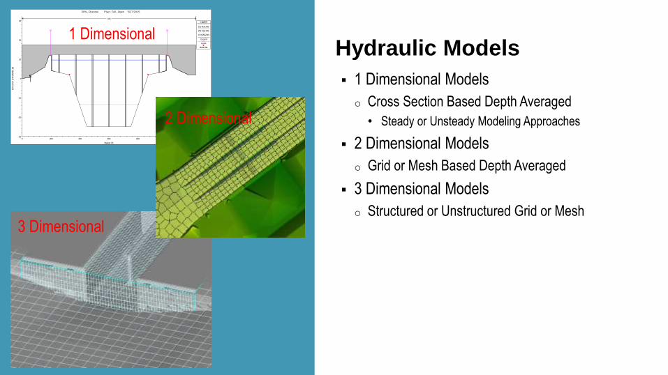
Hydraulic Models
1 Dimensional Models
o Cross Section Based Depth Averaged
• Steady or Unsteady Modeling Approaches
2 Dimensional Models
o Grid or Mesh Based Depth Averaged
3 Dimensional Models
o Structured or Unstructured Grid or Mesh
0 200 400 600 800 1000 1200-30
-20
-10
0
10
20
30
30%_Channel Plan: Full_Open 5/27/2015
Station (ft)
Ele
vation
(N
AV
D88
) (ft)
Legend
EG Max WS
WS Max WS
Crit Max WS
Ground
Levee
Bank Sta
.015
1 Dimensional
2 Dimensional
3 Dimensional
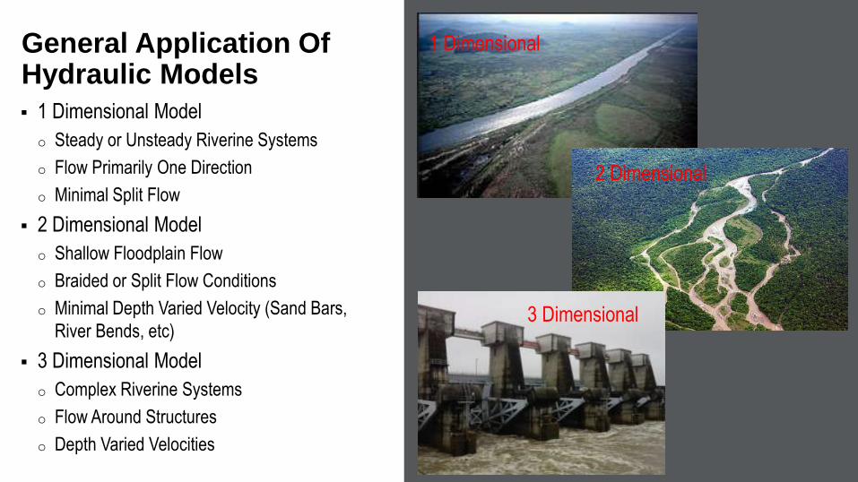
1 Dimensional Model
o Steady or Unsteady Riverine Systems
o Flow Primarily One Direction
o Minimal Split Flow
2 Dimensional Model
o Shallow Floodplain Flow
o Braided or Split Flow Conditions
o Minimal Depth Varied Velocity (Sand Bars,
River Bends, etc)
3 Dimensional Model
o Complex Riverine Systems
o Flow Around Structures
o Depth Varied Velocities
General Application Of Hydraulic Models
1 Dimensional
2 Dimensional
3 Dimensional
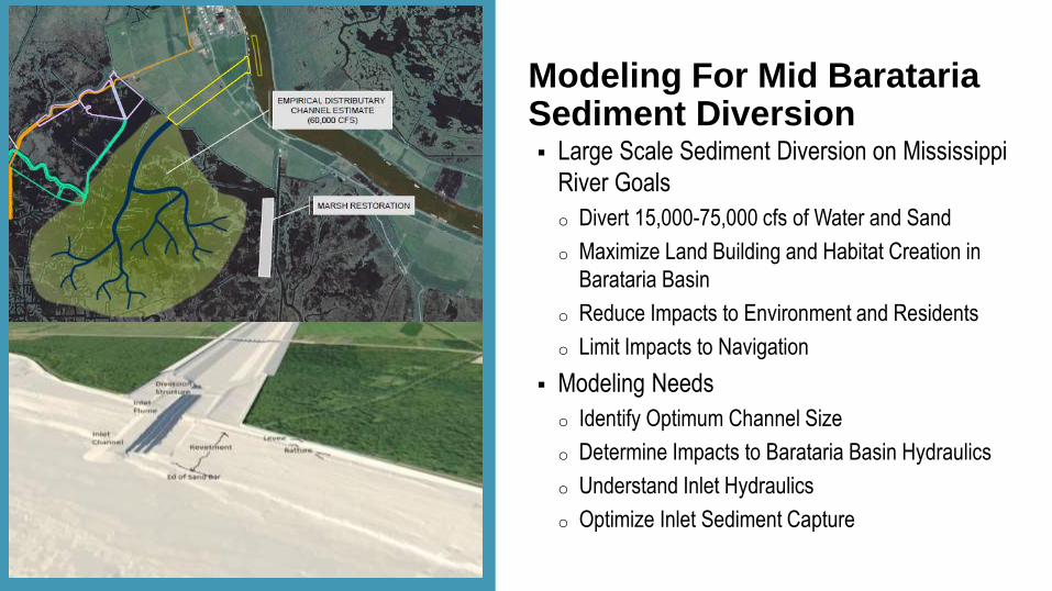
Modeling For Mid Barataria Sediment Diversion Large Scale Sediment Diversion on Mississippi
River Goals
o Divert 15,000-75,000 cfs of Water and Sand
o Maximize Land Building and Habitat Creation in
Barataria Basin
o Reduce Impacts to Environment and Residents
o Limit Impacts to Navigation
Modeling Needs
o Identify Optimum Channel Size
o Determine Impacts to Barataria Basin Hydraulics
o Understand Inlet Hydraulics
o Optimize Inlet Sediment Capture
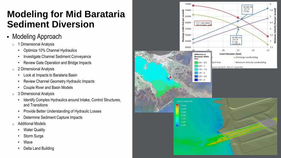
Modeling Approacho 1 Dimensional Analysis
• Optimize 10% Channel Hydraulics
• Investigate Channel Sediment Conveyance
• Review Gate Operation and Bridge Impacts
o 2 Dimensional Analysis
• Look at Impacts to Barataria Basin
• Review Channel Geometry Hydraulic Impacts
• Couple River and Basin Models
o 3 Dimensional Analysis
• Identify Complex Hydraulics around Intake, Control Structures,
and Transitions
• Provide Better Understanding of Hydraulic Losses
• Determine Sediment Capture Impacts
o Additional Models
• Water Quality
• Storm Surge
• Wave
• Delta Land Building
Modeling for Mid Barataria Sediment Diversion
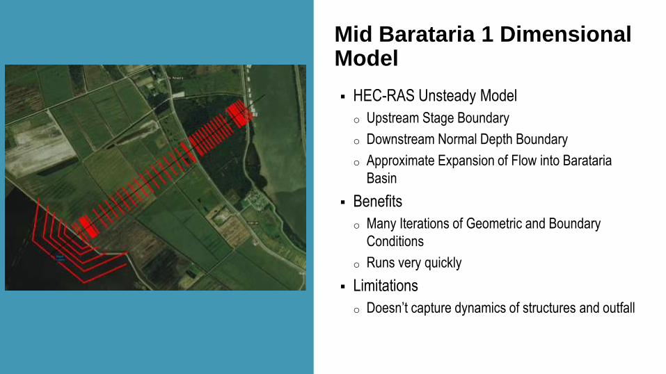
Mid Barataria 1 Dimensional Model
HEC-RAS Unsteady Model
o Upstream Stage Boundary
o Downstream Normal Depth Boundary
o Approximate Expansion of Flow into Barataria
Basin
Benefits
o Many Iterations of Geometric and Boundary
Conditions
o Runs very quickly
Limitations
o Doesn’t capture dynamics of structures and outfall

HEC-RAS 2D Model
o Barataria Basin
o Linked River, Channel, Outfall Model
• 1-Mile Outfall Area
Benefits
o Easy to set up
o Relatively fast model run times
o Large model domain
o Stable platform
Limitations
o More difficult to run iterations of geometry
o Doesn’t capture depth varied velocities around
structures
Mid Barataria 2 Dimensional Model
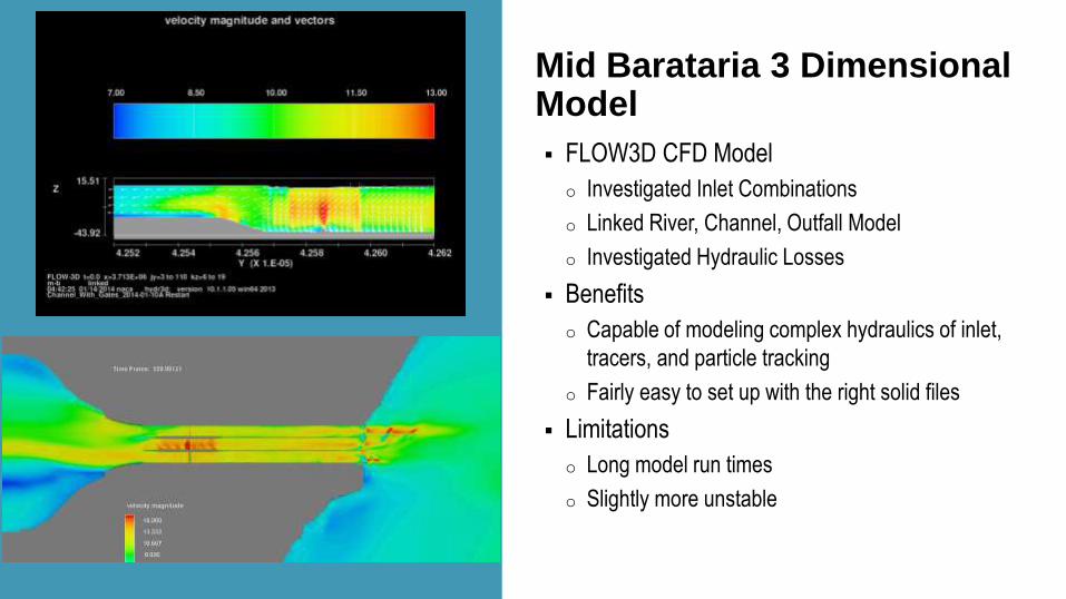
Mid Barataria 3 Dimensional Model
FLOW3D CFD Model
o Investigated Inlet Combinations
o Linked River, Channel, Outfall Model
o Investigated Hydraulic Losses
Benefits
o Capable of modeling complex hydraulics of inlet,
tracers, and particle tracking
o Fairly easy to set up with the right solid files
Limitations
o Long model run times
o Slightly more unstable
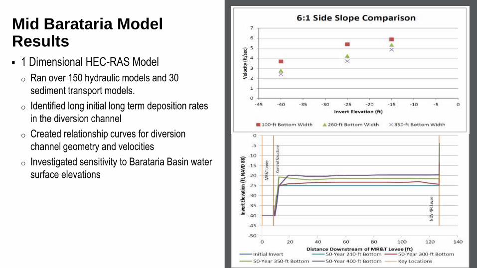
1 Dimensional HEC-RAS Model
o Ran over 150 hydraulic models and 30
sediment transport models.
o Identified long initial long term deposition rates
in the diversion channel
o Created relationship curves for diversion
channel geometry and velocities
o Investigated sensitivity to Barataria Basin water
surface elevations
Mid Barataria Model Results
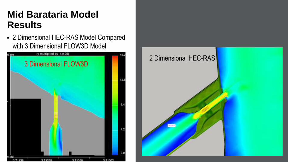
2 Dimensional HEC-RAS Model Compared
with 3 Dimensional FLOW3D Model
Mid Barataria Model Results
2 Dimensional HEC-RAS3 Dimensional FLOW3D

2 Dimensional HEC-RAS Model Compared
with 3 Dimensional FLOW3D Model
Mid Barataria Model Results
2 Dimensional HEC-RAS
2 Dimensional HEC-RAS
3 Dimensional FLOW3D
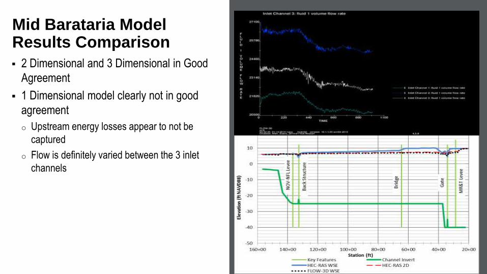
2 Dimensional and 3 Dimensional in Good
Agreement
1 Dimensional model clearly not in good
agreement
o Upstream energy losses appear to not be
captured
o Flow is definitely varied between the 3 inlet
channels
Mid Barataria Model Results Comparison

Barataria Basin Water Surface Elevations
o Low gradient – downstream water surface
elevations have large impact on diversion
discharges
o Circulation patterns can impact water quality in
Barataria Basin
o Tidal action and influence draining of Barataria
Basin
Mid Barataria Model Coordination

Mid Barataria Model Coordination
Inlet Losses
o Much greater than expected ~ 2 ft
o Adjusted HEC-RAS model for inlet losses
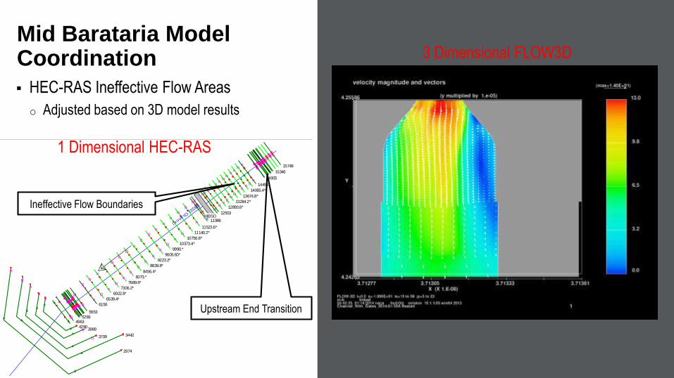
HEC-RAS Ineffective Flow Areas
o Adjusted based on 3D model results
Mid Barataria Model Coordination
MBSD
15748
15346
14905
14456
14065.4*
13674.8*
13284.2*
12893.6*
12503
11986
11523.6*
11140.2*
10756.8*
10373.4*
9990.*
9606.60*
9223.2*
8839.8*
8456.4*
8073.*
7689.6*
7306.2*
6922.8*
6539.4*
6156
5653
52894963
42903989
3709 3442
2974
MBSD_Channel
Upstream End Transition
Ineffective Flow Boundaries
3 Dimensional FLOW3D
1 Dimensional HEC-RAS
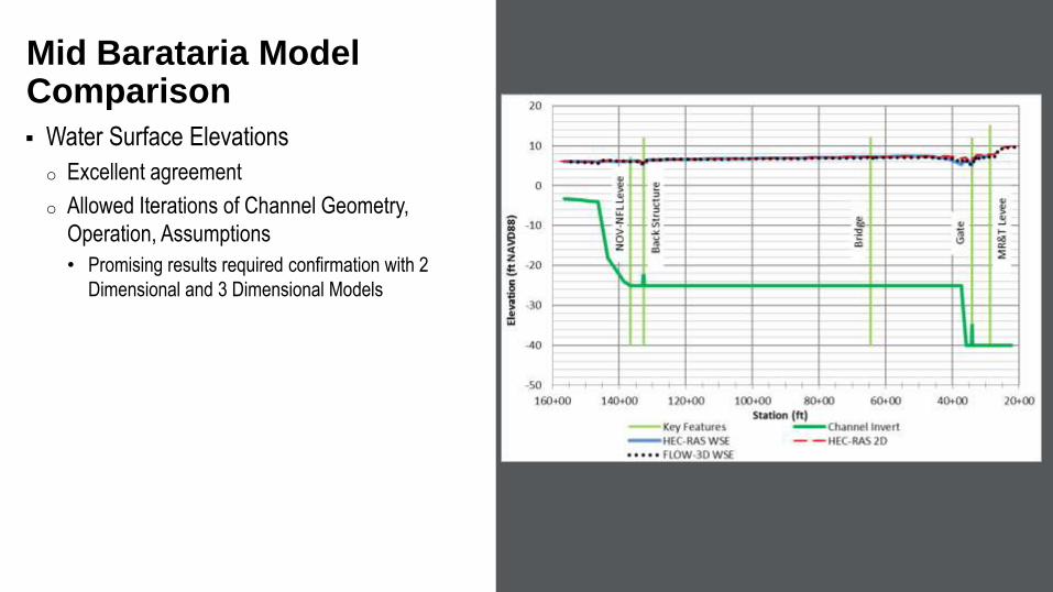
Water Surface Elevations
o Excellent agreement
o Allowed Iterations of Channel Geometry,
Operation, Assumptions
• Promising results required confirmation with 2
Dimensional and 3 Dimensional Models
Mid Barataria Model Comparison

Mid Barataria Model Results
Sediment Capture Rates
o Based on depth and particle size
Mid Barataria Modeling
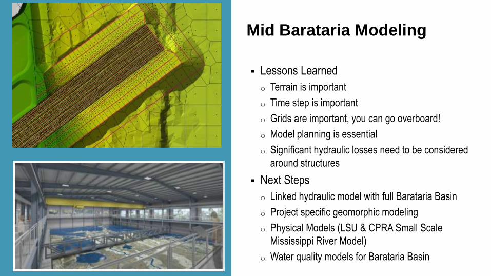
Lessons Learned
o Terrain is important
o Time step is important
o Grids are important, you can go overboard!
o Model planning is essential
o Significant hydraulic losses need to be considered
around structures
Next Steps
o Linked hydraulic model with full Barataria Basin
o Project specific geomorphic modeling
o Physical Models (LSU & CPRA Small Scale
Mississippi River Model)
o Water quality models for Barataria Basin
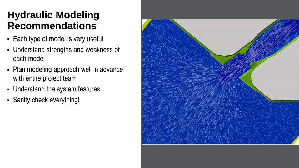
Each type of model is very useful
Understand strengths and weakness of
each model
Plan modeling approach well in advance
with entire project team
Understand the system features!
Sanity check everything!
Hydraulic Modeling Recommendations

Questions?


