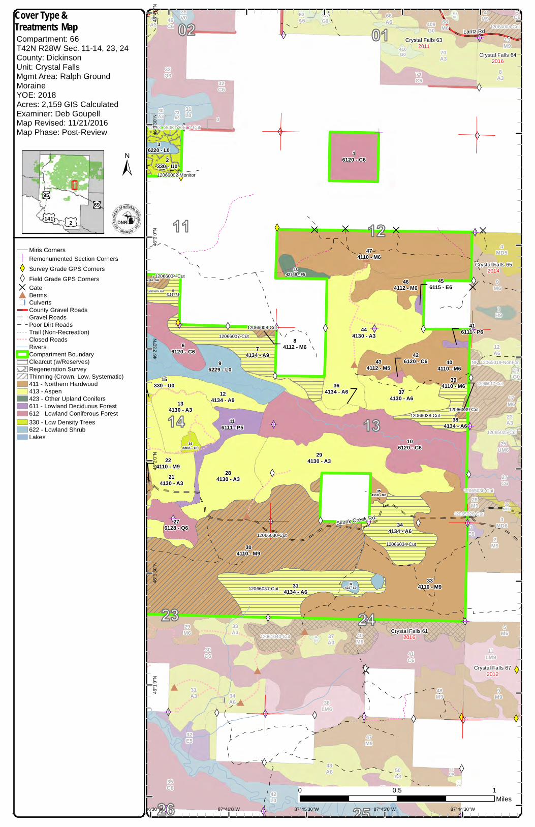
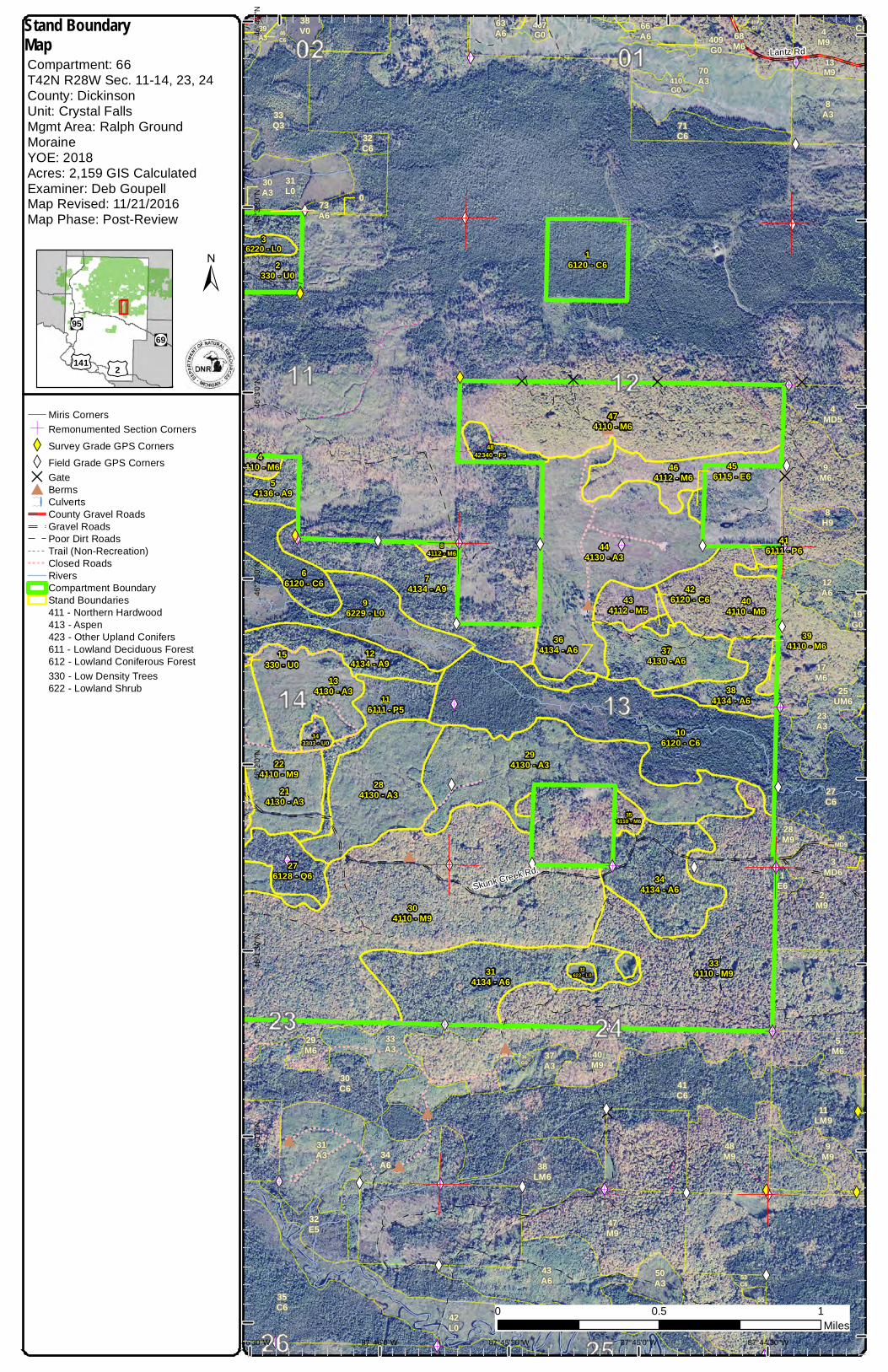
County Acreage: Entry Year Compartment Compartment Review Presentation Forest Management Unit Crystal Falls 12066 2018 2,159 Dickinson Management Area: Ralph Ground Moraine Legal Description: Identified Planning Goals: Soil and topography: Ownership Patterns, Development, and Land Use in and Around the Compartment: Unique Natural Features: Archeological, Historical, and Cultural Features: Special Management Designations or Considerations: Watershed and Fisheries Considerations: Wildlife Habitat Considerations: Mineral Resource and Development Concerns and/or Restrictions Vehicle Access: Survey Needs: Recreational Facilities and Opportunities: T42N R28W Sec 11-14, 23,24 Manage all forest types on a healthy, sustainable rotation. Encourage diversity within stands. Protect all bodies of water. Emmet fine sandy loam dominates the uplands. North half of this compartment is mostly private. Some scattered individual 40s in the south and adjacent. Skunk Creek and North Br. Skunk Creek None. Arnold-Ford River Obligate Deer Wintering Area Skunk Creek and North Br. Skunk Creek are good quality trout streams. This compartment is in the Ralph Ground Moraine Management Area which has the following featured species: American woodcock, black bear, northern goshawk, ruffed grouse, and white-tailed deer. Balancing the age classes of aspen to provide early successional habitat through mature aspen forest is a goal in this compartment. This compartment falls within the historic Skunk Creek Deeryard now included in the Arnold-Ford River DWC. Lowland conifers and lowland hardwood types provide winter and summer cover and are essential for travel corridors for a many species of wildlife, most importantly for wintering deer and spring/summer habitat for bears. They also provide essential habitat for riparian species along river systems. Mesic conifer in the uplands is promoted to provide structural diversity within stands which increases habitat value, as cover for wildlife and allow wintering deer to access forage in the uplands. Mast production, such as oak, cherry and raspberry are encouraged to provide valuable forage for bear, deer, grouse and turkey. This compartment has several hunter walking trails and maintained openings that provide herbaceous spring and summer forage particularly important for wildlife, and provide recreational opportunities for consumptive and non-consumptive wildlife users. Surface sediments consist of medium and coarse-textured glacial till. The glacial drift thickness varies between 10 and 50 feet. The Cambrian Munising and Precambrian Archean Volcanics and sedimentary rocks subcrop below the glacial drift. There is no current economic use for these rocks. The Groveland Iron mine is located approximately ten miles to the southwest. Sections 11 – 14 are currently leased for metallic exploration. Gravel pits are located to the south and there is potential. There is no economic oil and gas production in the UP. Limited on north by private land but State forest road cuts through the south portion. Corners will be needed. Trapping, hunting, fishing. Revision Date: 2016-08-20 Stand Examiner: Deb Goupell 12/28/2016 10:54:42 AM - Page 1 of 2 POLEYN
Ownership Patterns, Development, and Land Use in and Around the Compartment:
Unique Natural Features:
Archeological, Historical, and Cultural Features:
Special Management Designations or Considerations:
Watershed and Fisheries Considerations:
Wildlife Habitat Considerations:
Mineral Resource and Development Concerns and/or Restrictions
Vehicle Access:
Survey Needs:
Recreational Facilities and Opportunities:
T42N R28W Sec 11-14, 23,24
Manage all forest types on a healthy, sustainable rotation. Encourage diversity within stands. Protect all bodies of water.
Emmet fine sandy loam dominates the uplands.
North half of this compartment is mostly private. Some scattered individual 40s in the south and adjacent.
Skunk Creek and North Br. Skunk Creek
None.
Arnold-Ford River Obligate Deer Wintering Area
Skunk Creek and North Br. Skunk Creek are good quality trout streams.
This compartment is in the Ralph Ground Moraine Management Area which has the following featured species: American woodcock, black bear, northern goshawk, ruffed grouse, and white-tailed deer. Balancing the age classes of aspen to provide early successional habitat through mature aspen forest is a goal in this compartment. This compartment falls within the historic Skunk Creek Deeryard now included in the Arnold-Ford River DWC. Lowland conifers and lowland hardwood types provide winter and summer cover and are essential for travel corridors for a many species of wildlife, most importantly for wintering deer and spring/summer habitat for bears. They also provide essential habitat for riparian species along river systems. Mesic conifer in the uplands is promoted to provide structural diversity within stands which increases habitat value, as cover for wildlife and allow wintering deer to access forage in the uplands. Mast production, such as oak, cherry and raspberry are encouraged to provide valuable forage for bear, deer, grouse and turkey. This compartment has several hunter walking trails and maintained openings that provide herbaceous spring and summer forage particularly important for wildlife, and provide recreational opportunities for consumptive and non-consumptive wildlife users.
Surface sediments consist of medium and coarse-textured glacial till. The glacial drift thickness varies between 10 and 50 feet. The Cambrian Munising and Precambrian Archean Volcanics and sedimentary rocks subcrop below the glacial drift. There is no current economic use for these rocks. The Groveland Iron mine is located approximately ten miles to the southwest. Sections 11 – 14 are currently leased for metallic exploration. Gravel pits are located to the south and there is potential. There is no economic oil and gas production in the UP.
Limited on north by private land but State forest road cuts through the south portion.
The following reports from the Inventory are attached: Total Acres by Cover Type and Age Class Cover Type by Harvest Method Proposed Treatments – No Limiting Factors Proposed Treatments – With Limiting Factors Stand Details (Forested and Nonforested) Dedicated and Proposed Special Conservation Areas Site Condition Details
The following information is displayed, where pertinent, on the attached compartment maps: Base feature information, stand boundaries, cover types, and numbers Proposed treatments Site condition boundaries Details on the road access system
Stand BoundaryMapCompartment: 66T42N R28W Sec. 11-14, 23, 24County: DickinsonUnit: Crystal FallsMgmt Area: Ralph GroundMoraineYOE: 2018Acres: 2,159 GIS CalculatedExaminer: Deb GoupellMap Revised: 11/21/2016Map Phase: Post-Review
"M
!.!.
!.
!.
!.
!.
"M
f#
D
#
D
D
#
#
# D
#
#
#
DD D
XW
XW
XW XW XW
XWXW
XW
XW
XW
XW
XWXWXW
XW
XW
XW
XW
XWXWXW
XW
XW
XW
XW
XW
XW
XW
XW
XW XW
XW
XWXW XWXW XW
XW
XW
XWXW XW XWXW
XW
XW
XW XW
XW
XW
XW
XW
Ó
Ó
Ó
Ó
Ó
Ó
Ó Ó
Ó
Ó
Ó
Ó
Ó
Ó
Ó
Ó
Ó
Ó
Ó
Ó
Ó
Ó
Ó
Ó
Ó
ÓÓ
Ó
Ó
Ó
Ó
Ó
Ó
Ó
Ó
Skunk Creek Rd.
Lantz Rd
2G - 3
3J - 9
3J - 4
3G - 31
073A6
63A6
66A639
A3
30A3
3MD6
25UM6
409G0
46C6
5C - 8
16120 - C62
330 - U0
36220 - L0
44110 - M6
54136 - A9
96229 - L0
66120 - C6 7
4134 - A9
444130 - A3
474110 - M6
464112 - M6
434112 - M5
374130 - A6
404110 - M6
384134 - A6
294130 - A3
106120 - C6
284130 - A3
116111 - P5
134130 - A3
214130 - A3
276128 - Q6
304110 - M9
314134 - A6
32622 - L0
334110 - M9
344134 - A6
354110 - M6
4842340 - F5
143303 - U0
84112 - M6
124134 - A9
426120 - C6
456115 - E6
224110 - M9
15330 - U0 39
4110 - M6
416111 - P6
364134 - A6
36G0
42L0
19G0
13M9
9M6
4M9
40M9
47M9
48M9
28M9
2M9
5M6
9M9
17M6
29M6
55A3
50A3
43A6
31A3
33A3
12A6
23A3
8A3
34A6
37A3
70A3
4MD5
30MD9
1E6
32E5
35C6
30C6 41
C6
53C6
27C6
5C6
45Q6
38LM6
11LM9
31L0
407G0
408G0
410G0
68M6
8H9
71C632
C6
33Q3
38V0
5E - 15E - 3
3J - 4
3H - 7
5E - 95E - 9
5E - 9
5E - 11
5C - 63
5F - 4
5F - 2
5C - 65
87°44'30"W87°45'0"W87°45'30"W87°46'0"W87°46'30"W
46°4
'0"N
46°3
'30"N
46°3
'0"N
46°2
'30"N
46°2
'0"N
46°1
'30"N
46°1
'0"N
0 10.5Miles
Miris CornersÓ Remonumented Section CornersXW Survey Grade GPS CornersXW Field Grade GPS CornersD Gate# Bermsf Culverts
County Gravel RoadsGravel RoadsPoor Dirt RoadsTrail (Non-Recreation)Closed RoadsRiversCompartment Boundary
\\ Available w/ Constraints\\ Unavailable
5C: Delay treatment for age/size classdiversity or exceptional site quality3H: Deer Wintering Areas3J: Water quality / BMPs (stream, river,or lake)5E: Long-Term RetentionStand BoundariesNatural Beauty RoadsCold Water StreamsDeer Winter Range
"!(95"!(69
£¤141£¤2
±
Special Conservation Areas& Site Conditions MapCompartment: 66T42N R28W Sec. 11-14, 23, 24County: DickinsonUnit: Crystal FallsMgmt Area: Ralph GroundMoraineYOE: 2018Acres: 2,159 GIS CalculatedExaminer: Deb GoupellMap Revised: 11/21/2016Map Phase: Post-Review
"M
!.!.
!.
!.
!.
!.
"M
f#
#
#
D
#
D
D
#
#
D
#
# D
D
#
#
#
#
D D
XW
XW
XW
XW
XW XW
XWXW
XW
XWXWXW
XW
XW
XW XW
XW
XW
XW
XWXW
XW
XW
XWXW
XW
XW
XW XW
XW
XWXW XWXW XW
XW
XW
XWXWXW
XW
XW XWXW
XW XW
XW
XWXW
XW
XW
XW
XW
ÓÓ
Ó
Ó
Ó
Ó
Ó Ó
Ó
Ó
Ó
Ó
Ó
Ó
Ó
Ó
Ó
Ó
ÓÓÓ
Ó
Ó
Ó
Ó
Ó
Ó
Skunk Creek Rd.
0
36G0
42L0
22L0
27M9
40M9
21M9
47M9
48M9
46M6
43M6
29M6
31A3
33A3
50A3
1A3
23A3
43A6
24A3
26A3
47A3
3A3
37A3
34A6
35A3
30A3
70A3
32E535
C6
30C6
28C5
23C6
26C6
41C6
2C6
22C5
25Q5
45Q6
38LM6
48L0
31L0
407G0
410G0
36M9
71C632
C6
33Q3
38V0
0
73A6
27A6
39UM6
409G0 68
M6
49H5
12061021-Cut
12061027-Cut
12061040-Cut
12063_OutOfYOE_1-Cut
12062002-Cut
12062027-Cut
12066004-Cut
12066005-Cut
12066007-Cut12066008-Cut
12066024-Cut
12066031-Cut
12066034-Cut
12066030-Cut
12066038-Cut
12066002-Monitor1
6120 - C6
2330 - U0
36220 - L0
44110 - M6
54136 - A9
194134 - A6
96229 - L0
66120 - C6
74134 - A9
444130 - A3
474110 - M6
464112 - M6
434112 - M5
374130 - A6
404110 - M6
294130 - A3
106120 - C6
284130 - A3
116111 - P5
134130 - A316
4130 - A3
176124 - Q620
4130 - A3
224110 - M9
236120 - C6
214130 - A3
276128 - Q6
304110 - M9
314134 - A6
32622 - L0
334110 - M9
344134 - A6
354110 - M6
4842340 - F5
143303 - U0
15330 - U0
84112 - M6
124134 - A9 42
6120 - C6
456115 - E6
384134 - A6
244110 - M6
264130 - A6
256220 - L0
184134 - A9
364134 - A6
Crystal Falls 612016
Crystal Falls 622017
Crystal Falls 632011
87°45'0"W87°45'30"W87°46'0"W87°46'30"W87°47'0"W
46°3
'30"N
46°3
'0"N
46°2
'30"N
46°2
'0"N
46°1
'30"N
46°1
'0"N
46°0
'30"N
0 10.5Miles
Miris CornersÓ Remonumented Section CornersXW Survey Grade GPS CornersXW Field Grade GPS CornersD Gate# Bermsf Culverts
5C: Delay treatment for age/size classdiversity or exceptional site quality3H: Deer Wintering Areas3J: Water quality / BMPs (stream, river,or lake)5E: Long-Term RetentionStand BoundariesCold Water StreamsDeer Winter Range
"!(95"!(69
£¤141£¤2
±
Special Conservation Areas& Site Conditions MapCompartment: 66T42N R28W Sec. 11-14, 23, 24County: DickinsonUnit: Crystal FallsMgmt Area: Ralph GroundMoraineYOE: 2018Acres: 2,159 GIS CalculatedExaminer: Deb GoupellMap Revised: 11/21/2016Map Phase: Post-Review
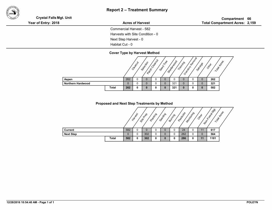
Report 1 – Total Acres by Cover Type and Age ClassCompartmentMgt. Unit
WLD- Featured species: deer, bear. Mesic conifer in the uplands is promoted to provide structural diversity within stands which increases habitat value, as cover for wildlife. Mast production, such as oak, cherry and raspberry are encouraged to provide valuable forage for bear, deer, and grouse. Trees showing potential for nesting bird, and providing nesting and denning cavities should be retained.
Mark to BA 70-80, focusing on removal of poor quality stems, releasing crowns of crop trees. Access through private
OtherComment:
PrescriptionSpecs:
4 4110 - Sugar Maple Association
Acceptable Regen:
Site Condition:
Draft Field Boundary
111-140
Proposed Start Date: 10/01/2016
9.3
Next Step Treatments:
Uneven-Aged
Habitat Cut: No
12066005-Cut 73Sawtimber Well
mixed conifer, mixed hardwood
413 - AspenHarvest Clearcut with Retention
Access is through private. may want to consider winter harvest due to shallow soils and private access. may startFY 2017 if corner are in and time permitsWLD-featured species: American woodcock, black bear, northern goshawk, ruffed grouse, and white-tailed deer. Balancing the age classes of aspen to provide early successional habitat through mature aspen forest is a goal in this compartment. . Mesic conifer in the uplands is promoted to provide structural diversity within stands which increases habitat value, as cover for wildlife. Mast production, such as oak, cherry and raspberry are encouraged to provide valuable forage for bear, deer, and grouse. Drainages and associated ash should be protected as critical bear habitat.
Cut all species 2" and up except cedar and pine. Retention around cedar pocket on west line.
Mgt. Unit Report 3 -- Treatments Compartment:Year of Entry:S
tand
Approval Status
BA Range
Crystal Falls 662018
Age Structure
12066007-Cut 76Sawtimber Well
mixed softwood, mixed hardwood, pine
413 - AspenHarvest Clearcut with Retention
May start FY 2017 if corners are in and time permitsWLD-featured species: American woodcock, black bear, northern goshawk, ruffed grouse, and white-tailed deer. Balancing the age classes of aspen to provide early successional habitat through mature aspen forest is a goal in this compartment. . Mesic conifer in the uplands is promoted to provide structural diversity within stands which increases habitat value, as cover for wildlife. Mast production, such as oak, cherry and raspberry are encouraged to provide valuable forage for bear, deer, and grouse. Drainages and associated ash should be protected as critical bear habitat.
Cut all tree 2" dbh and up except cedar and pine. Cedar pocket are in south central of stand. Recommend winter cut. Treatment reflects 300' buffer to Skunk Ck, which will serve as retention.
may start FY 2017 if corners are in and time permitsWLD-Featured species: deer, bear, pileated woodpecker. Retaining and promoting mesic conifer within stand diversity is important such as White pine, hemlock, cedar and submerchantible spruce/fir . Oak and cherry should be maintained for mast production. Trees showing potential for nesting birds, and providing nesting and denning cavities should be retained.
Thin to around 90 BA as stand is quite thick. 80 BA in less dense areas. Focus on removing aspen and poor quality stems to release potential crop tree crowns.
OtherComment:
PrescriptionSpecs:
8 4112 - Maple, Beech, Cherry
Association
Acceptable Regen:
Site Condition:
Draft Field Boundary
111-140
Proposed Start Date: 10/01/2016
3.6
Next Step Treatments:
Even-Aged
Habitat Cut: No
12066014-NF Nonstocked 310 - Herbaceous
Openland
NonForestMgt Herbaceous/Crop/Grass Planting
Herbaceous opening maintenance
OtherComment:
PrescriptionSpecs:
14 3303 - Mixed Low Density Trees
Acceptable Regen:
Site Condition:
Draft Field Boundary
Unspecified
Proposed Start Date: 10/01/2017
5.1
Next Step Treatments:
Habitat Cut: No
12/28/2016 10:54:21 AM - Page 2 of 5 POLEYN
TreatmentName
Acres StandAge
Cover TypeObjective
SizeDensity
TreatmentType
TreatmentMethod
Stand CoverType
Mgt. Unit Report 3 -- Treatments Compartment:Year of Entry:S
tand
Approval Status
BA Range
Crystal Falls 662018
Age Structure
12066015-NF Nonstocked 310 - Herbaceous
Openland
NonForestMgt Herbaceous/Crop/Grass Planting
Herbaceous opening maintenance
OtherComment:
PrescriptionSpecs:
15 330 - Low-Density Trees
Acceptable Regen:
Site Condition:
Draft Field Boundary
Unspecified
Proposed Start Date: 10/01/2017
5.6
Next Step Treatments:
Habitat Cut: No
12066024-Cut 93Poletimber Well
411 - Northern Hardwood
Harvest Crown Thinning
Thin to BA 80 removing poor quality stems and releasing crowns of crop trees.
OtherComment:
PrescriptionSpecs:
24 4110 - Sugar Maple Association
Acceptable Regen:
Site Condition:
Field Boundary - Ready for
VMS
111-140
Proposed Start Date: 11/20/2015
3.0
Next Step Treatments:
Even-Aged
Habitat Cut: No
12066030-Cut 95Sawtimber Well
411 - Northern Hardwood
Harvest Crown Thinning
This will be a light thinning for the most part.WLD-Featured species: Deer, Bear . DWC- . Mesic conifer in the uplands is promoted to provide structural diversity within stands which increases habitat value, as cover for wildlife. Mast production, such as oak, cherry and raspberry are encouraged to provide valuable forage for bear, deer, and grouse. Maintenance of diverse species for structural diversity such as refuge, cover and den trees is important numerous wildlife species in addition to the featured species.Drainages and vernal pools should be protected as critical bear habitat. Propose wildlife underplant of white pine or hemlock.
Thin to BA 80. Focus on removal of poor stems and those competing with crowns of crop trees. Wildllife prefers winter cut.
OtherComment:
PrescriptionSpecs:
30 4110 - Sugar Maple Association
Acceptable Regen:
Site Condition:
Draft Field Boundary
111-140
Proposed Start Date: 10/01/2017
302.0
Planting, UnderplantNext Step Treatments:
Even-Aged
Habitat Cut: No
12/28/2016 10:54:21 AM - Page 3 of 5 POLEYN
TreatmentName
Acres StandAge
Cover TypeObjective
SizeDensity
TreatmentType
TreatmentMethod
Stand CoverType
Mgt. Unit Report 3 -- Treatments Compartment:Year of Entry:S
tand
Approval Status
BA Range
Crystal Falls 662018
Age Structure
12066031-Cut 85Poletimber Well
mixed softwood, mixed hardwood
413 - AspenHarvest Clearcut with Retention
There is a tag swale in center of stand.WLD- featured species: American woodcock, black bear, northern goshawk, ruffed grouse, and white-tailed deer. Balancing the age classes of aspen to provide early successional habitat through mature aspen forest is a goal in this compartment. Mesic conifer in the uplands is promoted to provide structural diversity within stands which increases habitat value, as cover for wildlife. DWC -forage for deer. Mast production, such as oak, cherry and raspberry are encouraged to provide valuable forage for bear, deer, and grouse. Wet forested lowland important habitat for bear and had evidence of heavy deer browse-DWC.
Cut all stems 2"dbh and greater except cedar and pine. Winter harvest due to very shallow soils. Be sure to capture aspen along edge of hardwood stand. Retain submerchantable ash and hemlock.
WLD-Featured Species: Deer, Bear, Grouse. Balancing the age classes of aspen to provide early successional habitat through mature aspen forest is a goal in this compartment. Mesic conifer in the uplands is promoted to provide structural diversity within stands which increases habitat value, as cover for wildlife. Retention of White Pine, hemlock, and cedar component for refuge trees and cover for bear and deer is desirable. This compartment is in DWC-transitions from lowlands are critical for wintering deer to access upland and reach forage in uplands Mast production, such as oak, cherry and raspberry are encouraged to provide valuable forage for bear, deer, grouse. Drainages and associated ash should be protected as critical bear habitat.
Cut all stems 2" dbh and greater except cedar (pine, if found).In addition 2-6" dbh sugar maple should be protected (heaviest in south/southeast quarter of this stand). Possibly put retention in this area? There are pockets of lowlands, ash swales and vernals in here. Paint out vernals and winter cut.
WLD-Featured Species: Deer, Bear, Grouse. Balancing the age classes of aspen to provide early successional habitat through mature aspen forest is a goal in this compartment. Mesic conifer in the uplands is promoted to provide structural diversity within stands which increases habitat value, as cover for wildlife. Retention of White Pine, hemlock, and cedar component for refuge trees and cover for bear and deer is desirable. This compartment is in DWC-transitions from lowlands are critical for wintering deer to access upland and reach forage in uplands Mast production, such as oak, cherry and raspberry are encouraged to provide valuable forage for bear, deer, grouse. Drainages and associated ash should be protected as critical bear habitat.
Cut all stems 2" dbh and greater except pine and cedar, hemlock if found.
Mgt. Unit Report 3 -- Treatments Compartment:Year of Entry:S
tand
Approval Status
BA Range
Crystal Falls 662018
Age Structure
12066039-Cut 85Poletimber Well
411 - Northern Hardwood
Harvest Crown Thinning
Thin to BA 80
OtherComment:
PrescriptionSpecs:
39 4110 - Sugar Maple Association
Acceptable Regen:
Site Condition:
Draft Field Boundary
141-170
Proposed Start Date: 09/01/2015
2.7
Next Step Treatments:
Even-Aged
Habitat Cut: No
617.0Total Treatment Acreage Proposed:
12/28/2016 10:54:21 AM - Page 5 of 5 POLEYN
Report 4 – Site ConditionsCompartment:Mgt. UnitYear of Entry:: Examiner
Crystal Falls
Deb Goupell
662018
*Due to limitations in the current Site Conditions Analysis tool, all nonforested acres are considered available. Future development will enable analysis of nonforested types.
Dominant Site Condition AcresSiteNo. Other Site Condition Other Site Condition Other Site Condition Other Site Condition
Dominant Site Cond Availability
1 5E: Long-Term Retention 3J: Water quality / BMPs (stream, river, or lake)
32 Unspecified Unspecified Unspecified
Comments:
Unavailable
2 5E: Long-Term Retention 3J: Water quality / BMPs (stream, river, or lake)
6 Unspecified Unspecified Unspecified
Comments:
Unavailable
3 5E: Long-Term Retention 3J: Water quality / BMPs (stream, river, or lake)
6
a portion of this stand is in the 300 ft buffer to Skunk Ck
11 5E: Long-Term Retention 2F: Too steep7 Unspecified Unspecified Unspecified
Comments:
Unavailable
12/28/2016 10:54:42 AM - Page 2 of 2 POLEYN
SCA Category Acres
Mgt. Unit
Report 5 – PROPOSED SPECIAL CONSERVATION AREA* (SCA) DETAILS
Compartment:
Recommendation
* This is a partial list of SCAs for this compartment. Not included are those areas identified under other Department initiatives (Natural Rivers, Deer Wintering Areas, etc.). Those will be identified in separate, future map and report products.
Year of Entry:
SCA Name Detail Type
Crystal Falls 0662018
40
Deer yard covers this SCA
Potential Old Growth SCA RemovalComments
1675
Deer yard covers this SCA
Potential Old Growth SCA RemovalComments
12/28/2016 10:54:13 AM - Page 1 of 1 POLEYN
Type
Mgt. Unit Compartment:
Description
* This is a list of SCA's for this compartment along with a 1/4 mile buffer surrounding the compartment. Refer to the Special Conservation Area Map for locations of the below listed Conservation Areas.
Report 6 – EXISTING SPECIAL CONSERVATION AREA DETAILS
Conservation Area SCA = Special Conservation Area
HCVA = High Conservation Value AreaERA = Ecological Reference Area
Year of EntryCrystal Falls 66
2018
A coldwater lake has temperature and dissolved oxygen conditions that allow naturally-reproduced or stocked trout populations and those of other coldwater fish species to persist from year to year. Suitable conditions for coldwater fishes may occur in Michigan lakes if they are relatively deep, have substantial groundwater inflows, or are located in colder (northern) areas of the state. Such lakes are established by Director's action and designated as trout resources by Fisheries Order 200.
Cold Water LakeSCA
A coldwater stream has temperature and dissolved oxygen conditions that allow naturally-reproduced or stocked trout populations and those of other coldwater fish species (e.g., slimy sculpin) to persist from year to year. Coldwater streams in Michigan typically provide these conditions due to substantial contributions of groundwater to their stream flows. Such streams are established by Director's action and designated as trout resources by Fisheries Order 210.
Cold Water Stream
SCA
An area that provide some specific need for the life cycle of wildlife species, including State Wildlife Areas and Waterfowl Production Areas, deer wintering complexes in lowland conifer communities, grassland openings and savannas. Habitat areas are distinct from critical habitat designated for recovery of endangered or threatened species (such as Kirtland's warbler or piping plover areas) in that they are more general in nature, are not primarily associated with threatened or endangered species, and are not covered by species recovery plans that are developed in cooperation with Federal agencies.
Habitat AreaSCA
12/28/2016 10:54:12 AM - Page 1 of 1
Level 4 Cover Type Acres
StandAge
SizeDensity
BA Range
Mgt. Unit Report 7 – Forested Stands Compartment:Stand
GeneralComments:
Year of Entry:Crystal Falls
201866
1 6120 - Lowland Cedar Poletimber Well
40.5 95 81-110
4 4110 - Sugar Maple Association
Poletimber Well
9.3 93 111-140 Ash is browsed hard, 2 leaf maples fairly consistent through the stand. Stand has some great crop sugar maple.
5 4136 - Aspen, Mixed Conifer
Sawtimber Well
40.9 73 Unspecified Much of conifer is dead and aspen is breaking up. Concentrate retention around cedar pockets. Recommend winter cut due to
age and shallow soils.
6 6120 - Lowland Cedar Poletimber Well
41.5 90 Unspecified
7 4134 - Aspen, Spruce/Fir
Sawtimber Well
65.9 76 Unspecified a lot of dying spruce/ fir with a lot of it on the ground. cedar pockets south central of stand. Winter cut recommended
8 4112 - Maple, Beech, Cherry Association
Poletimber Well
3.6 93 111-140 Very thick stand, high BAs. Has potential but a lot of poor quality to remove
10 6120 - Lowland Cedar Poletimber Well
138.1 85 Unspecified
11 6111 - Lowland Balsam Poplar
Poletimber Medium
29.4 51 Unspecified North half of this stand is poorly stocked, with black ash. The south tail has a bed and bank
12 4134 - Aspen, Spruce/Fir
Sawtimber Well
32.0 90 Unspecified Retention for Rolling Tundra TS, just south
13 4130 - Aspen Sapling Well 51.5 7 Immature Rolling Tundra TS 2010. East end of stand has more drainages and wet areas
WLD- Hunter walking trail in stand. Herbaceous/opening maintenance
16 4130 - Aspen Sapling Well 19.6 7 Immature ROLLING TUNDRA TSALE CLOSED 2010
17 6124 - Lowland Spruce-Fir
Poletimber Well
14.3 49 Unspecified heavier to birch in northwest corner. Lower ground but not overly wet. Little volume just yet.
18 4134 - Aspen, Spruce/Fir
Sawtimber Well
5.6 90 Unspecified Retention for ROLLING TUNDRA TSALE( CLOSED 2010). within 300 ft of Skunk Ck
19 4134 - Aspen, Spruce/Fir
Poletimber Well
9.8 80 Unspecified Most of this stand is within 300 ft buffer to Skunk Creek
20 4130 - Aspen Sapling Well 9.0 7 Immature ROLLING TUNDRA TSALE CLOSED 2010