Page 1 STATE OF MARYLAND MARYLAND GEOLOGICAL SURVEY Permit Number _..:::8'-'<.9 __ Well Number __ -,2 __ The Johns Hopkins University BALTIMORE, MARYLAND 21218 Texas Eastern Transmission Corporation Company COMPLETION REPORT County __ G_a_r_r_e_t_t __ (oil or gas well) This report must be submitted within 30 days after completion of the well WELL DESCRIPTION - KIND OF WELL: ____ __ , , ( Oil Gas Other) U.S.A. Savage River State Forest, Well In Size of Packers: Used in Left in NAME & WELL NO. Casting and Type, Size and Drilling Well Savage River State Tubing Depth ELEVATION: 2772 GR. LEASE: Forest 13 3L8 " 134' - 119 ' None DRILLING DRILLING COMMENCED: 6/15/69 COMPLETED: 7/15/69 9 5/8 " 3920' -- None PRODUCTION: Gas - See Below 7" 8151' 8138 ' None 7" Stage Collar @ 7032'. Not RESERVOIR PRESSURE Measured psig hrs. WELL TREATMENT: (Shooting, Acidizing, Fracturing, Etc.) PERFORATIONS AT : 7908-5 See Attached Data - 7992-8010';8022- Chert: 7580-90 ' 0' 46 I, 16QQ-1Q' ; 162 - 7640-50' ; 7660- 7 0' - CEMENTING DATA: (Size Pipe, Depth, No. Bags, Date) 13 3/8", - 134' , 175 sx., 6-15-69 9 5/8", 3920' , 800 sx., 6-25-69 7" 8151' , 1st Stage 340 sx. around bottom "- , RESERVOIR PRESSURE AFTER TREATMENT: -_ casing. 2nd Stage 1250 sx. thru Stage collar Not Measured @ 7032'. RESULTS AFTER TREATMENT: 7,923 MCFGD - "" - "" - REMARKS: GEOPHYSICAL LOGS (Type of Geophysical Logs Run on Well) Formation Density Gannna Ray - Neutron Completion Report continued on page 2
Transcript
Page 1 STATE OF MARYLAND
MARYLAND GEOLOGICAL SURVEY
Permit Number _..:::8'-'<.9 __
Well Number __ -,2 __ The Johns Hopkins University
BALTIMORE, MARYLAND 21218 Texas Eastern Transmission Corporation Company
COMPLETION REPORT County __ G_a_r_r_e_t_t __ (oil or gas well)
This report must be submitted within 30 days after completion of the well
WELL DESCRIPTION - KIND OF WELL: ____ --=G=-:a=s~(S=_t:.....:o...:.r...:.:.a~ge~)~ __ , , ( Oil Gas Other)
U.S.A. Savage River State Forest, Well In Size of Packers: Used in Left in NAME & WELL NO.
REMARKS: GEOPHYSICAL LOGS (Type of Geophysical Logs Run on Well)
Formation Density Gannna Ray - Neutron
Completion Report continued on page 2
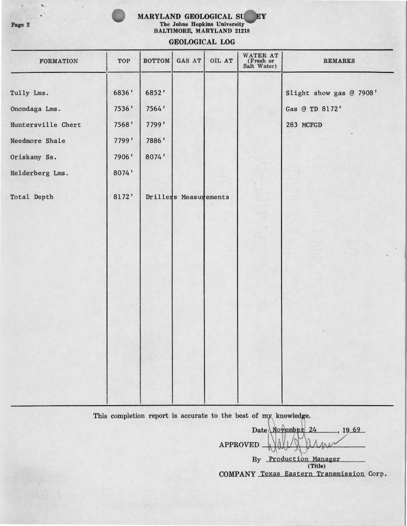
Page 2'
FORMATION
Tully Lms.
Onondaga Lms.
Huntersville Chert
Needmore Shale
Oriskany Ss.
Helderberg Lms.
Total Depth
I TOP
6836'
7536 '
7568 '
7799 '
7906 '
8074'
8172 '
MARYLAND GEOLOGICAL S ......... ~Y The Johns Hopkins University
BALTIMORE, MARYLAND 21218
GEOLOGICAL LOG
WATER AT BOTTOM GAS AT OIL AT (Fresh or
Salt Water)
6852'
7564 '
7799 '
7886 '
8074'
Drille s Measu ements
REMARKS
Slight show gas @ 7908'
Gas @ TD 8172'
283 MCFGD ,
This completion report is accurate to the . best of m
Date f~~~~~~ __ __
APPROVED ~c-l-tJ,~'-*\-b!'.,.<..I".<~<--------
By Production Manager (Title)
COMPANY Texas Eastern Transmission. Corp.
.' /
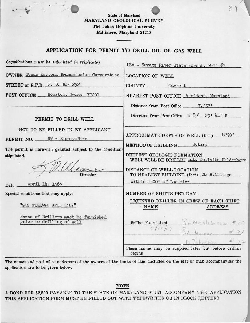
State of Maryland
MARYLAND GEOLOGICAL SURVEY The Johns Hopkins University
Baltimore, Maryland 21218
APPLICATION FOR PERMIT TO DRILL OIL OR GAS WELL
(Applications must be submitted in triplicate) USA Savage R· St t F t W 11 #2 - ~ver a e ores e !
OWNER Texas Eastern Transmission Corporation LOCATION OF WELL
STREET or R.F.D. P. O. Box 2521 COUNTY Garrett
POST OFFICE Houston . Texas 77001 NEAREST POST OFFICE Accj dent . Maryland
Distance from Post Office 7:9571
PERMIT TO DRILL WELL Direction from Post Office N B9° 29 1 ~~II E
NOT TO BE FILLED IN BY APPLICANT
82 - Eight~-Nine APPROXIMATE DEPTH OF WELL (feet) 8220 '
PERMIT NO. METHOD OF DRILLING Rot ar;y
The pez:mit is herewith granted subject to the condit iom stipulated.
~~ DEEPEST GEOLOGIC FORMATION
WELL WILL BE DRILLED Into Definite He1derbe
DISTANCE OF WELL LOCATION TO NEAREST BUILDING (feet) No BlljJdings . _ DIrector
Date April 14,! 1969 Within 1500 1 of Ipcatj on
Special conditions that may apply: NUMBER OF SHIFTS PER DAY
LICENSED DRILLER IN CREW OF EACH SHIFT ltGAS STORAGE WELL ONLY" NAME ADDRESS
Names of Drillers must be furnished
rg
Erior to drilling of well !l1el"'15 e Furni shed f' K I hj 1 J It! br ·ff / . /1 /t t; -1\/ h r;I" 'l r ( /'.-' -
'\ # ,
These names may be supplied later but before drilling begins
The names and post office addresses of the owners of the tracts of land included on the plat or map accompanying the application are to be given below.
NOTE
A BOND FOR $2,500 PAYABLE TO THE STATE OF MARYLAND MUST ACCOMPANY THE APPLICATION THIS APPLICATION FORM MUST BE FILLED OUT WITH TYPEWRITER OR IN BLOCK LETTERS
I
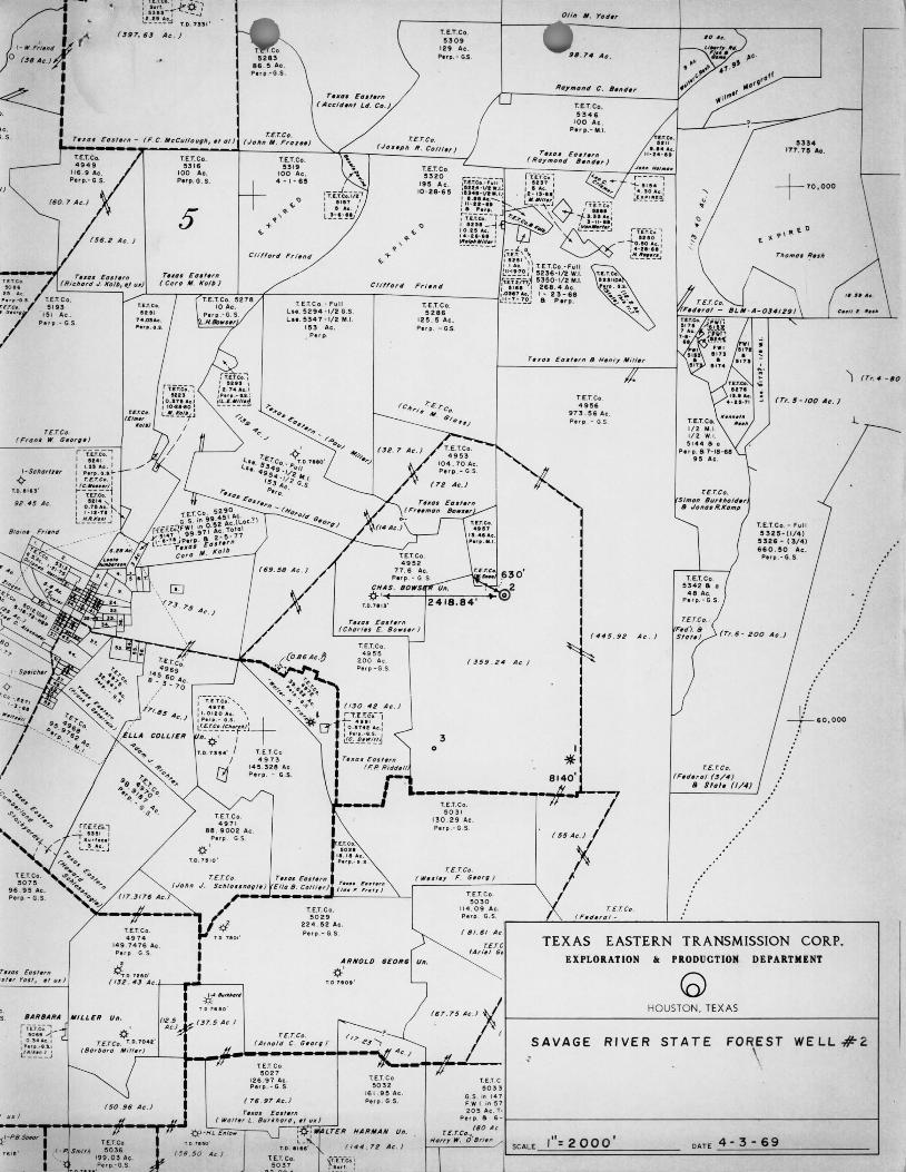
" ; , 5
I)
(60. 7 Ac. )
r £. T.Co. r Fronk W. 6.0',.,
1-$chDrfr.r
-¢-T,O • • t', ' 92 . 45 Ac.
T'XQ$ Eo"'Tn 'sf , r Yo". " 1I1f }
e. S.
" Ii
'S}.-PBSP«IT
16 15 '
~~u::~~y~:~? , ' ( J97. 6.J Ac . )
5283 86 . 5 Ac . P.rp .-G .S .
T. E.T.Co. 5309
129 At . Perp. - G.S.
r'Xt,. Ell""" (A c c i dnl Ld.
T. E.T.C o. · Fu ll L ... 5294 ·1/2 G.S l ... 5347 ·1/2 M.I.
153 At . • P e r p.
( £1. Co. ( JO'.ph R . Co lIl . r J
T.O. 71 ' "
T.E .T.Co. 5320
195 Ac . 10 ' 28-65
T. E.T. Co. 5286
125 . !5 Ac. P, r ., . -G.S
r'ID, ED.t'Tn (Ch orl., E. 80"" ')
98 . 7., Ac .
rt.i: ic~"I I •••• I
""f 1 .nA • . : , ... 1 - 11- " 1
~~-*'!'~ 'fen; '
I '110 '
-i:::~- :~ : L~-!.-!.·~·.J
T.E.T.Co . - Fu l l 5236 -1/2 W.I. 5350·1/2 Mol. 268. <4 Ac. 1- 23-68 8; P.rp .
T. E.T. Co 4956
973 . 56 Ac. Plr p . -GS
( ""5 . 92 A c . '
5334 177. 75 Ac .
+ 70,000
T. E.T. Co . - F u ll 5325-( 1/ 4) 5326 - (3/ 4 ) 660 . 50 Ac .
Perp . - G. S.
') ( Tr. " - 60
T.E.T.Co , 4 95"5
200 Ac P'r p.-G .S
( .J59 . 24 A c. )
, ~ O. U 50'
T.E.T.Co. 49 71
88 . 9 0 02 At . Perp . G.S .
~ ' 1. 0 . 75 10'
T. E.T, Co. 5 0 29
2 2 4 . 52 Ac . Perp .- G. S.
ARNOLD
~' (02. 4., ~c,/-_",,,,,, __ ---, T. O.7'O"
(58.50 Ac I
r. E.rco. ( A r no l d C . G.o r g )
T.E .T.Co 502 1
12 6 .91 Ac . Pup. - G. S
T. E.T. Co 50 32
161. 95 Ac . Perp . G. S.
LTER HARMAN Ult .
T.E.T. Co. 5 0 37
II "" 72 Ac . I
3 o
T.E.T,Co. 50 3 1
13 0 . 29 Ae . Perp .-G .S
T. E.r.eo. ( W., I . y F G'O Tt} )
I
'* 8140'
+ 60,000 r.£. r.C~.
( F.d. r a l (J/ '" • $1.1. (1 / 4)
.'
TEXAS EASTERN TRANSMISSION CORP. EXPLORATION Ii< PRODUCTION DEPARTMENT