98527 98537 98547 98577 98586 98590 985HH 985XX 98614 98624 98631 98638 98640 98641 98644 986HH 986XX Pacific Adna Boistfort Centralia Cosmopolis Elma Longview Naselle-Grays River North River Oakville Ocean Beach Ocosta Pe Ell Raymond Rochester South Bend Vader Wahkiakum Willapa Valley Composite Risk Score SOURCES: DSHS Research and Data Analysis, Community Outcome and Risk Evaluation Geographic Information System (CORE-GIS). County, School District, and ZCTA boundaries from US Census Bureau 2009 TIGER files. ¯ 10 Miles by Zip Code Tabulation Area (ZCTA), Pacific County, 2009 Composite Risk Score VERY HIGH high average low November 22, 2010 School Districts Counties Highways Water DATA NOTES: Composite Risk Score is an average of risk scores for the following three domains: Poor Mental Health, Economic Deprivation, and Troubled Families. The domain risk scores were calculated using standardized indicators in each domain. Composite Risk Score for each ZCTA is mapped based on the standard deviations from the mean score. ZCTAs are generalized area representations of ZIP Code service routes developed by the Census Bureau for tabulating summary data from Census 2000. Not applicable
Transcript
98527
98537
98547
98577
98586
98590
985HH
985XX
98614
98624
9863198638
9864098641
98644
986HH
986XX
Pacific
Adna
Boistfort
Centralia
Cosmopolis Elma
Longview
Naselle-GraysRiver
NorthRiver
Oakville
OceanBeach
Ocosta
Pe Ell
Raymond
Rochester
SouthBend
Vader
Wahkiakum
WillapaValley
Composite Risk Score
SOURCES: DSHS Research and Data Analysis, Community Outcome and Risk Evaluation Geographic InformationSystem (CORE-GIS). County, School District, and ZCTA boundaries from US Census Bureau 2009 TIGER files.
¯10Miles
by Zip Code Tabulation Area (ZCTA), Pacific County, 2009
Composite Risk ScoreVERY HIGHhighaveragelow November 22, 2010
School DistrictsCountiesHighwaysWater
DATA NOTES: Composite Risk Score is an average of risk scores for the following three domains: Poor Mental Health, Economic Deprivation, and Troubled Families. The domain risk scores were calculated using standardized indicatorsin each domain. Composite Risk Score for each ZCTA is mapped based on the standard deviations from the mean score.ZCTAs are generalized area representations of ZIP Code service routes developed by the Census Bureau for tabulating summary data from Census 2000.
Not applicable
98527
98537
98547
98577
98586
98590
985HH
985XX
98614
98624
9863198638
98640
98641
98644
986HH
986XX
Pacific
NorthRiver
OceanBeach
Ocosta
Pe Ell
Raymond
SouthBend
WillapaValley
Suicide and Suicide Attempts (Age 10-17)
SOURCES: DSHS Research and Data Analysis, Community Outcome and Risk Evaluation Geographic InformationSystem (CORE-GIS). County, School District, and ZCTA boundaries from US Census Bureau 2009 TIGER files.
¯7Miles
by Zip Code Tabulation Area (ZCTA), Pacific County, 2009
Rate compared to the StateVERY HIGHhighaveragelow or very low December 13, 2010
School DistrictsCountiesWater
DATA NOTES: The number of adolescents (age 10-17) who committed suicide or were admitted to the hospital for suicide attempts, per 100,000 adolescents (age 10-17). Suicides are based on death certificate information. Suicide attempts are based on hospital admissions, but do not include admissions to federal hospitals. ZCTAs are generalized area representations of ZIP Code service routes developed by the Census Bureau for tabulating summary data from Census 2000.
Not applicable
98527
98537
98547
98577
98586
98590
985HH
985XX
98614
98624
9863198638
98640
98641
98644
986HH
986XX
Pacific
NorthRiver
OceanBeach
Ocosta
Pe Ell
Raymond
SouthBend
WillapaValley
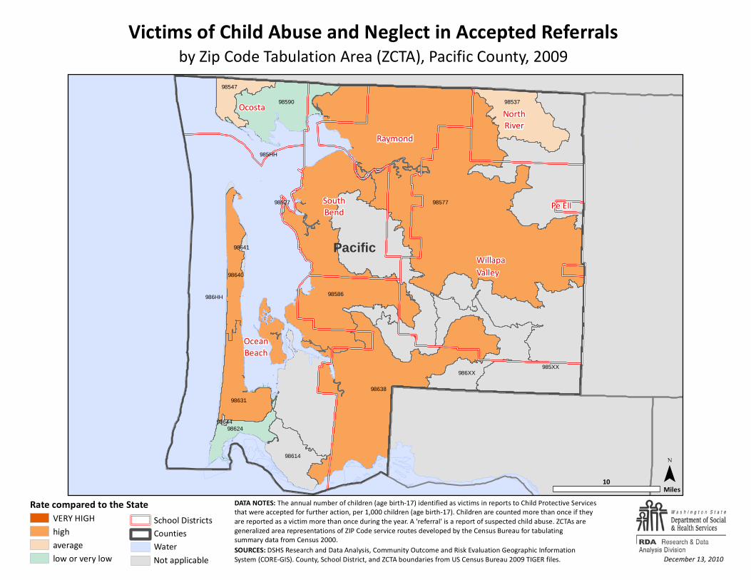
Victims of Child Abuse and Neglect in Accepted Referrals
SOURCES: DSHS Research and Data Analysis, Community Outcome and Risk Evaluation Geographic InformationSystem (CORE-GIS). County, School District, and ZCTA boundaries from US Census Bureau 2009 TIGER files.
¯10Miles
by Zip Code Tabulation Area (ZCTA), Pacific County, 2009
Rate compared to the StateVERY HIGHhighaveragelow or very low December 13, 2010
School DistrictsCountiesWater
DATA NOTES: The annual number of children (age birth-17) identified as victims in reports to Child Protective Servicesthat were accepted for further action, per 1,000 children (age birth-17). Children are counted more than once if they are reported as a victim more than once during the year. A 'referral' is a report of suspected child abuse. ZCTAs are generalized area representations of ZIP Code service routes developed by the Census Bureau for tabulating summary data from Census 2000.
Not applicable
98527
98537
98547
98577
98586
98590
985HH
985XX
98614
98624
9863198638
98640
98641
98644
986HH
986XX
Pacific
NorthRiver
OceanBeach
Ocosta
Pe Ell
Raymond
SouthBend
WillapaValley
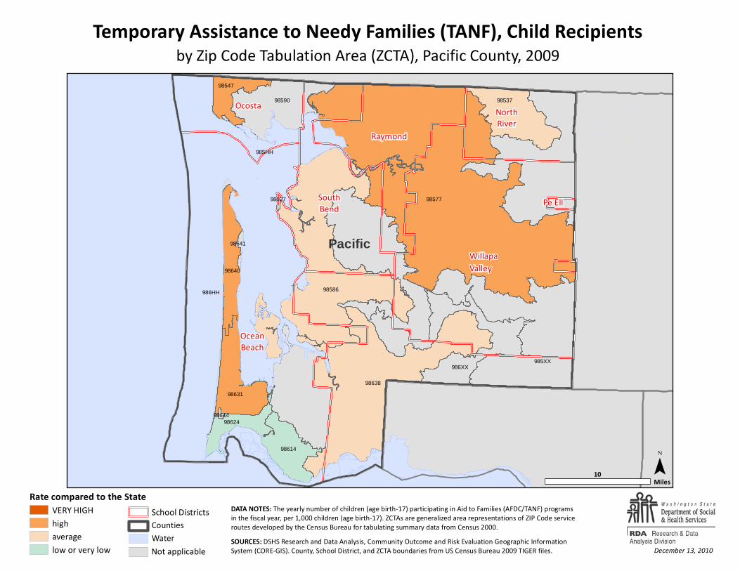
Temporary Assistance to Needy Families (TANF), Child Recipients
SOURCES: DSHS Research and Data Analysis, Community Outcome and Risk Evaluation Geographic InformationSystem (CORE-GIS). County, School District, and ZCTA boundaries from US Census Bureau 2009 TIGER files.
¯10Miles
by Zip Code Tabulation Area (ZCTA), Pacific County, 2009
Rate compared to the StateVERY HIGHhighaveragelow or very low December 13, 2010
School DistrictsCountiesWater
DATA NOTES: The yearly number of children (age birth-17) participating in Aid to Families (AFDC/TANF) programsin the fiscal year, per 1,000 children (age birth-17). ZCTAs are generalized area representations of ZIP Code service routes developed by the Census Bureau for tabulating summary data from Census 2000.
Not applicable
98527
98537
98547
98577
98586
98590
985HH
985XX
98614
98624
9863198638
98640
98641
98644
986HH
986XX
Pacific
NorthRiver
OceanBeach
Ocosta
Pe Ell
Raymond
SouthBend
WillapaValley
Food Stamp Recipients (All Ages)
SOURCES: DSHS Research and Data Analysis, Community Outcome and Risk Evaluation Geographic InformationSystem (CORE-GIS). County, School District, and ZCTA boundaries from US Census Bureau 2009 TIGER files.
¯8Miles
by Zip Code Tabulation Area (ZCTA), Pacific County, 2009
Rate compared to the StateVERY HIGHhighaveragelow or very low December 13, 2010
School DistrictsCountiesWater
DATA NOTES: The number of persons (all ages) receiving food stamps in the fiscal year, per 1,000 persons (all ages). ZCTAs are generalized area representations of ZIP Code service routes developed by the Census Bureau for tabulating summary data from Census 2000.