Page 1
ISSN: 1857-9000, EISSN: 1857-9019
http://mmm-gi.geo-see.org
7
COMPOSITION OF COASTAL VEGETATION IN AND
AROUND THE TRADITIONAL GRAZING ROUTES OF
CAMELS IN KACHCHH, GUJARAT-INDIA
Ajoy DAS1 , Pankaj JOSHI2, Mahendra BHANANI3 and Ritesh
POKAR4
UDC: 502.211:582]:528.931(540)
ABSTRACT
Natural resources provide a range of interrelated environmental interaction and
socioeconomic benefits, which support a diversity of livelihood policies for different
stakeholders of the local community. The Pastoralist community locally called
Maldharis who is sifting one place to another place for their survival. Since the land
is not suitable for agriculture, conventional development by-passed the region. Some
Part of Landscape in Kachchh is considered as a biosphere reserve for its wildlife
and plant ecosystem. The nomads tend to migrate with their economic betterment
and better livelihood. Both food crops and multipurpose crops are being grown
together with livestock management. The people lighting their hopes with the
migration process. This region is rich in natural resources and livestock resources.
The existing natural resources and the long coastline is also contributing a major part
in the district economies. The grazing animals depended on natural vegetation, so
need to prepare a cluster level seasonal Grazing route map of Camel pastoralist with
the help of a participatory approach. Through the natural resource map, the
community will easily find out the areas which are rich in natural vegetation and
nearest safe water bodies for the animals on their grazing route. The participatory
method helped a lot for this study to identify their temporal grazing location as well
as the grazing routes around the largest district (Kachchh) of India. The shrubs and
scrubs apart from the Prosopis juliflora are not in strength to protect erosions and
since considered as an invasive species, should be remove from native habitats of
Kachchh. The sweeping high wind velocity and high-temperature increase
evaporation both from the soil and all living flora and fauna. Saving land and
1 PhD Dr. Ajoy DAS, [email protected] , Cartographer, Department of Geography, School
of Sciences, Gujarat University. Tel. +91 953 7753341. Address: Navrangpura, Ahmedabad-380009, Gujarat, India. 2 PhD Dr. Pankaj JOSHI, [email protected] , Programme Director, Biodiversity and Conservation,
Sahjeevan (NGO). Tel. +91 942 6949523. Address: Sahjeevan, 175-Jalaram Society, VijayNagar, Hospital Road, Bhuj- Kachchh, Gujarat- 370001 (India). 3 MSW. Mahendra BHANANI, [email protected] , Programme Coordinator, Sahjeevan (NGO).
Tel. +91 823 8019933. Address: Sahjeevan, 175-Jalaram Society, VijayNagar, Hospital Road, Bhuj- Kachchh, Gujarat- 370001 (India). 4 MSc. Ritesh POKAR, [email protected] , Programme Coordinator, Sahjeevan (NGO). Tel. +91 972
4727757. Address: Sahjeevan, 175-Jalaram Society, VijayNagar, Hospital Road, Bhuj- Kachchh, Gujarat- 370001 (India).
Page 2
No.15, Year 2020
Publisher: Geo-SEE Institute
8
maintaining it for better agricultural use in a planned way for eco-system
development retaining agrobiodiversity is a need. Wherever the environment is
suitable (not affecting the soil water relationships and efficiency) keeping in view
rainfed system agro-ecology needs to be developed.
Keywords: Natural Resources, Pastoralist, conservation, Participatory, GIS,
Wetland.
1. INTRODUCTION
Kachchh district has the highest wetland (51.72%) area including seasonal
and saline marshy area of RANN among all districts of the Gujarat state. The
Kachchh Peninsula located between 22° 44' to 24° 41' North latitude and 68°
10' and 71° 43' East, forms the westernmost part of India and constitutes the
Kachchh district of Gujarat State. This district has wide coverage as 45652
sq. km area of the Gujarat state. This district has 10 talukas such as Bhuj,
Gandhidham, Anjar, Rapar, Mandvi, Bhachau, Mundra, Nakhtrana, Abdasa,
Lakhpat. The total population is 2,092371 and the population density is 46
people /sq. km. The average literacy rate of this area is 70.59%. The western
part of the Gujarat state of India is surrounded by the Arabian sea and the
other three parts of this state are covered by the dynamic landmasses. The
geographical extension of this state is Latitude 20o 06' N to 24o 41' N and
Longitude 68o 10' E to 74o 28' E. This region is under the subtropical climate
zone and over the whole region, there are several sub climate regions. The
monsoon season starts from June and stays up to October, similarly winter
months are November to February, summer months are March to June. Few
wetlands have safe drinking water but after March due to extreme heat and
the regional location, the normal water is converted into the saline water.
Eastern and northern part of the region is covered by Greater Rann of
Kachchh (GRK) and Little Rann of Kachh (LRK). Kachchh peninsula has
four ephemeral rivers as Khari, Pur, Kanaka Vati, and Gjansar (ORG, 1999;
CWC, 1997, and Planning Atlas of Gujarat). The Pastoralist community,
locally called Maldharis who are sifting one place to another place for their
survival, has camels, sheep, goats, cattle, and buffaloes; they produce ghee
(clarified butter), wool, and handicrafts. The water veins and groundwater
flow according to the regional slope aspect. Two types of camels identified
in Kachchh district i.e. the Kharai Camels, the unique breed of camels that
swim in the sea in search of mangroves, and the other one is Kachhi camel, a
breed of the camel that can’t swim in the sea, mostly depended on inland
grazing. The ecological barriers on the west are the river estuaries and
marshy lands. Vegetation in the marshy land and immediate inland is on the
verge of collapsing. The north of the middle ridge, a large spread of Banni
land, is traditionally devoid of agriculture and suitable only for grasses.
Page 3
ISSN: 1857-9000, EISSN: 1857-9019
http://mmm-gi.geo-see.org
9
However, people’s lifestyles and occupations are predominantly interwoven
with the Banni livestock and monsoon grasses. Handicrafts and embroidery
of the Banni Maldharis are world acclaimed. Cattle largely Kankrej breeds,
Sindhi buffalo, camel, sheep, and goat are the domesticated animals. In
every aspect of their day to day life, these animals are involved. A strong
emphasis is made here for agro-biodiversity and cultivated agriculture
development in Kachchh.
1.1 Need conservation for Biodiversity development
Kachchh is considered as a biosphere reserve for its unique wildlife and
plant ecosystem. Domestication of animals and livestock rearing, using the
plant resources, and natural grasses is a way of life. The nomads tend to
migrate with their economic betterment and better livelihood. The
availability of groundwater and rains has led to a stable life, which, together
brought in agriculture. Both food crops and multipurpose crops are being
grown together with livestock management.
Kachchh was and continues to be a major livestock rearing center. When an
agricultural ecosystem must be interwoven with it the ecosystem needs to be
protected, maintained, and further developed. In the present scenario, there is
a significant amount of soil erosion both by wind and water. The available
land needs to be saved from salinity and desertification. In the mainland
undulating hilly part of the district, vegetation of five major composition
types can be identified. They are open scrub, dense scrub, grasslands, shrub
savannah and tree savannah. Large parts of the landscape support the last
remaining patches of natural tropical thorn forests and savannah of the
country. Common plant species recorded from the landscape includes;
Acacia nilotica subsp. Indica (Deshi bavar), Acacia senegal (Kher, Gorad),
Capparis decidua (Ker), Euphorbia caducifolia (Thuar), Prosopis juliflora
(Gando bavar), Salvadora oleoides (Mithi jar), S. persica (Khari jar),
Prosopis cineraria (Kandho), Zizyphus mauritiana (Bor), and Z. nummularia
(Chani bor) in the top canopy, while Maytenus emarginata (Vikaro), Premna
resinosa (Kundheri), Corida perrottetii (Liyar), Grewia tenax (Gangni), G.
villosa (Luska) etc. constituted the under story. As tall trees with high
canopy except for Neem, Banyan, and Peepal in small scattered standings,
there is no windshield of natural source. The shrubs and scrubs apart from
the Prosopis juliflora are not in strength to protect erosions. The sweeping
high wind velocity and high-temperature increase evaporation both from the
soil and all living flora and fauna. Saving land and maintaining it for better
agricultural use in a planned way for eco-system development retaining
agrobiodiversity is a need. Irresponsible or thoughtless use of technological
applications needs to be given up. Fortunately, Kachchh is not much polluted
with green revolution setups and a package of practices. Wherever the
Page 4
No.15, Year 2020
Publisher: Geo-SEE Institute
10
environment is suitable (not affecting the soil water relationships and
efficiency) keeping in view rainfed system agro-ecology needs to be
developed.
1.2 The literature of the study
The broad objectives of this study are as follows-
I. A mapping exercise of Natural Resources with Pastoral Community
within a 25 kilometers buffer zone from the coastline.
II. Existence Status and Dependency on Natural Resources using GI
(Geographic Information) Science technology.
III. Participatory Conservation Management plan through the GIS tools.
Based on these objectives we had focused on the resources and
information available on a different website, published and
unpublished research reports, articles, etc.
1.2.1 International aspect
Kachchh district and its surrounding area have unique biodiversity, there is
no proportion between one taluka to another taluka. They all are different
with their flora and fauna distribution. There are many research works have
been done at the global level, here we had taken some recent research
findings as references. The increase in grazing pressure implies a reduction
in the production of palatable species and increases the proportion of
unpalatable as well as woody species (Perrings and Walker, 1995). As per
(Anteneh Belayneh et al., 2012) that the traditional medicinal plant species
are relevant for human health care as well as for the people living in
Ethiopia. Fifty systematically selected informants including fifteen
traditional herbalists (as key informants) participated in the study. Semi-
structured interviews, discussions, and guided field walk constituted the
main data collection methods. The species like Aloe pirottae, Azadirachta
indica, and Hydnora johannis were the most cited and preferred species.
Aloe pirottae, a species endemic to Ethiopia, is valued as a remedy for
malaria, tropical ulcer, gastro-intestinal parasites, gallstone, eye diseases,
and snakebite. The gel extracted from dried and ground plant material, called
SIBRI (Oromo language), was acclaimed as a cleaner of the human colon. A
concoction made from leaf, seed, and flower of Azadirachta indica was
given for the treatment of malaria, fungal infections, and intestinal worms.
Root preparations from Hydnora johannis were prescribed as a remedy for
diarrhea, hemorrhage, wound, and painful body swelling, locally called
GOFLA (Oromo language). (Kristine B. Garcia et al., 2014) discussed the
potential of the resource for development for the protection of the associated
indigenous medical experience as well as the development and effective use
of the medicinal plant resource. The status of the Philippines’ mangroves, its
Page 5
ISSN: 1857-9000, EISSN: 1857-9019
http://mmm-gi.geo-see.org
11
current and future threats, and analyzes the mechanisms on how various
stakeholders put efforts to address those threats. The similarities in issues
around wetland conservation and sustainability in three developing countries
using case studies of internationally significant wetlands in Tanzania,
Colombia, and Papua New Guinea. Planning processes, socio-economic
inequities, and conflicts are significant risks to some wetland values.
Mechanisms such as the Ramsar Convention provide a framework to assist
in addressing global wetland loss, but implementation at these sites needs to
be supported by effective, integrative approaches involving natural resource
regulation, conservation, and the development needs of local communities
by (Jasmyn J. Lynch et al. 2016). According to (Kathiresan Kandasamy
2017) in the last two decades, mangroves in India have been well maintained
without any drastic changes, because of effective conservation measures
being implemented in mangrove areas along with the country, despite
growing threats by man and natural calamities. (Anna C. Treydte et al. 2017)
said that the Afar pastoralists of Ethiopia mainly depend on natural
rangeland resources for their livestock. In times of severe drought, migrating
with livestock was most common. Participatory land-use mapping and
vegetation assessment has been done to identify the most important
rangeland locations and their condition in Afar. The average herbaceous
cover of rangelands was <25%. Afar pastoralists applied little conservation
and mitigation methods, most commonly they removed livestock pressure to
allow the pasture to recover. Afar pastoralists applied little rangeland
conservation and mitigation effort.
1.2.2 National aspect
When we are focusing on the national level study some people continue to
depend on locally available bio-resources for their livelihoods. Such
population who are directly dependent on local biological resources.
Through their keen sense of observation, practices, and experimentation
developed and established a body of knowledge that is passed on from
generation to generation. Some are widespread traditional knowledge like
cultivation practices by the (National Biodiversity of India, 2009). Defining
the spatial limits of biodiversity has evolved a further group of terms; α
(alpha), β (beta), and γ (gamma) diversity. This group of terms differentiates
between local species richness (‘α’ diversity, the number of species at a
location), the regional species pool (γ diversity, the number of different
species that could be at a location) and vary between localities (β diversity),
(Thompson et al. 2007).(Joshi et al, 2015) suggested that the total population
of the golden jackal, about half of the golden jackals were mostly found in
the Prosopis juliflora dominated habitat with an occurrence of 46.90%. This
was further followed by grassland, mixed thorn forest, and open scrubland
Page 6
No.15, Year 2020
Publisher: Geo-SEE Institute
12
with an occurrence of 31.25%, 9.91%, and 6.25% respectively. Minimum
numbers of jackals were recorded in the wetland habitats (5.69%). The
presence of a greater number of jackals in the Prosopis dominated area can
be attributed to the availability of shelter and food which is also comprised
of Prosopis juliflora pods and Ziziphus fruit. Habitats like Euphorbia scrubs,
Prosopis scrubs, thorn mixed scrubs, open scrubs, thorn mixed forests with
Acacia Senegal, Acacia nilotica, and Salvadora mixed considering the high
floral diversity and unique vegetation assemblage of this range, it has been
suggested that this tract and adjoining sites may be declared as Ecologically
Sensitive Areas (ESA), (Joshi 2002). On the other side (Das et. al. 2019)
found the threatened habitat area of Kachchh district and suggested the
suitable habitat areas for the wild animal with multi-criteria analysis. Some
threatened floral species are identified in the region Limonium stocks,
Dipcadi erythraeum, Talinum portulacifolium, Indigofera caerulea var.
monosperma and Ipomoea kotschyana, Commiphora wightii, Helicrysum
cutchicum, Convolvulus stockii and Heliotropium rariflorum, (Patel et. Al.,
2018). As per the published report wetland habitat accepting only three
threatened species i.e. Ammania desertorum, Dipacdi erythraeum, Ipomoea
kotschyana, has high preservation substantial. Including this Limonium
stocki and Talinum portulacifolium which were suggested preservation of
their habitat for survival, (Patel et. al. 2018). From this region, five species
of mammals observed also i.e. Canis lupus (Indian Wolf), Vulpes
bengalensis (Indian Fox), Hyaena hyaena (Striped Hyena), Panthera pardus
(Common Leopard), Felis silvestris (Desert Cat), Felis chaus (Jungle Cat),
Viverricula indica (Small Indian Civet), (Pardeshi et. al. 2010). Wetlands
consist of diversity according to their geographical location, nature,
dominated by flora and fauna species, soil, and sediment physiognomies
(Space Application Centre, 2010). According to (A. Rathore et al., 2013) the
ecosystem mainly di-vided into few subsystems where desertification is
expanding and the temperature making them drier and intolerable in terms of
the threatened species. The risk of wildfire is increasing which could change
the species biodiversity. Climate change is a threat to the diverse hotspots
(Succulent Karoo, South Africa). Many species are very specific and
endemic to this ecosystem and are rich natural reservoirs of goods. Based on
(Nikunj B. Gajera et al. 2013), observation in this Kachchh region the bird
species are widely distributed among various habitats around the western
Kachchh region. Various factors associated with different habitat types had a
distinct impact on bird species. Likewise, various land use activities
especially opencast mining that is being done on a mass scale in the region
also affect the bird populations considerably. According to (Nitin Bassi et al.
2014) observation of the wetland wealth of India in terms of their
geographical location, the ecosystem benefitted but due to various stresses
Page 7
ISSN: 1857-9000, EISSN: 1857-9019
http://mmm-gi.geo-see.org
13
like land-use changes in the catchment area, they went under the disturbed or
threatened wetland ecosystem. Encroachment of reservoir area for
industrialization, excessive diversion of water for agricultural practices is yet
a major problem (Verma, 2001). Lack of good governance and management
are also the main reason for the wetland ecosystem disturbance (Kumar et al.
2013). India, with its topographical variation, along with the climatic
mobility supports unique wetland habitats (Prasad et.al. 2002). National
Wetland Atlas 2011, prepared by SAC, is the latest inventory on Indian
wetlands. In this report total of 201,503 wetlands were identified and
mapped on a 1:50000 scale (SAC, 2010). According to the (SAC,2011)
Wetland Atlas reports there are 69% inland wetlands, coastal wetlands 27%,
and other wetlands (smaller than 2.25 ha) 4%. The aquatic vegetation in all
types of wetlands put together,1.32 m ha (9% of the total wetland area) in
post-monsoon and in pre-monsoon 2.06 m ha (14% of total wetland area).
The area under aquatic vegetation in Kachchh district is about 59132 ha in
the post-monsoon season and slightly high in the pre-monsoon season
(60381 ha). A total number of wetlands is 4659 (area 2360909 ha) in
Kachchh district, (SAC, 2010).
Many research works have been done by the Govt. Departments as Gujarat
Biodiversity Board, Gujarat Ecological Society, Geer Foundation, etc.
Except for these organizations some private NGO organization as Sahjeevan,
RAMBLE of Banni region, K-Link, Kachchh Unt Uchherak Maldhari
Sangathan (KUUMS), Banni Breeders’ Association, etc. They are working
with the pastoral community and Biodiversity conservation and management
sector. The soils of the Banni region are moderate to strongly saline and are
subject to flooding/inundation. The Rann is flat, largely composed of salt
and mud (Tiwari, C.B, et al. 1994). Due to this inundation factor, there is a
variation of vegetation also. The invasion species as Prosopis juliflora has
taken a major role to threaten the ecosystem through decreasing the grass
areas. This region is dependent on livestock farming. Kachchh district
support 1.4 million livestock, which yielded about 12% of milk and 21%
wool production of the state during 1994-95 (GEC, 1996). Community based
participatory natural resource management is being adopted widely as a
possible solution to address complex problems. Also, participation and
knowledge of local groups are understood to be a valuable resource in
community-level natural resource management, decision making, and policy
planning processes (Tripathi and Bhattarya, 2004). However, regardless of
its significant contribution to the economy of the district, the grazing
requirements of the district could not be met with the existing resources.
Increasing grazing pressure is also a major problem for this region so in that
position needs a conservation plan. Livestock based income is the mainstay
in Banni which was estimated as Rs. 7700/cattle/year and Rs.
Page 8
No.15, Year 2020
Publisher: Geo-SEE Institute
14
13,400/buffalo/year (Geevan et al. 2003). Livestock is the mainstay of
livelihood, (Joshi et al. 2009); (GUIDE, 2010). Besides, the socio-economic
survey (Joshi et al. 2009) noted that the Banni communities are highly
dependent on the natural grassland for various purposes. If this region
suffers from the various ecological problem, then it will be very tough for
their livelihood. Sahjeevan has tried to collaboration with Sardar Kushinagar
Dantiwada Agriculture University (SDAU), Dept. of Animal Husbandry,
Govt. of Gujarat for development of the Banni breed which was then
registered as 11th Buffalo breed in the country, (Joshi, P.N et al. 2009).
Local observations of grassland change and priorities for conservation of
natural resources in Banni, Gujarat, India sows the dynamic change of
biodiversity by (Das et al. 2018). Biodiversity threat through exotic species
monitoring and management using Remotely Sensed data and GIS
techniques- A Case Study of Banni (Kachchh) Gujarat, India (K.L.N. Sastry
et al. 2003) also shows the threatening species due to influencing various
factors. So, using space technology in this region will be a great achievement
for the development of the pastoral community as well as its ecosystem also.
1.3 Study Area
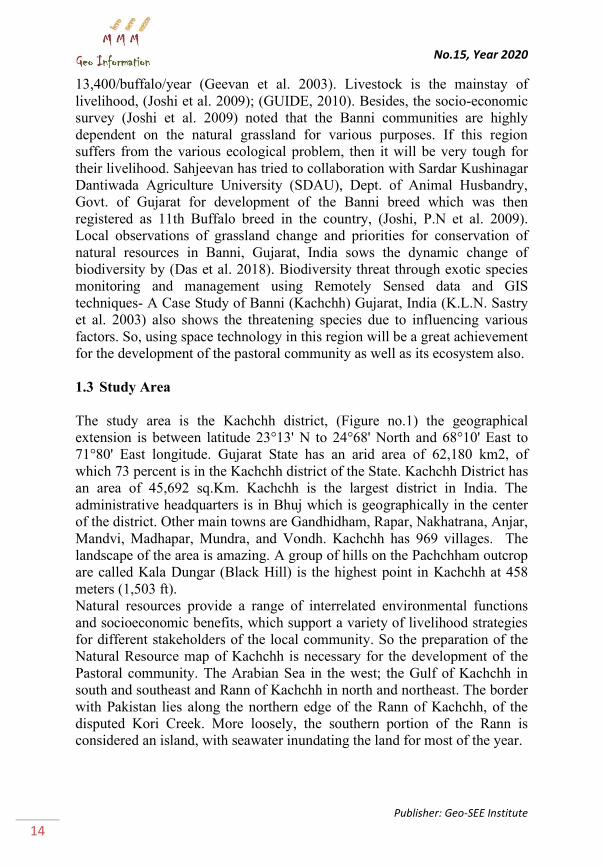
The study area is the Kachchh district, (Figure no.1) the geographical
extension is between latitude 23°13' N to 24°68' North and 68°10' East to
71°80' East longitude. Gujarat State has an arid area of 62,180 km2, of
which 73 percent is in the Kachchh district of the State. Kachchh District has
an area of 45,692 sq.Km. Kachchh is the largest district in India. The
administrative headquarters is in Bhuj which is geographically in the center
of the district. Other main towns are Gandhidham, Rapar, Nakhatrana, Anjar,
Mandvi, Madhapar, Mundra, and Vondh. Kachchh has 969 villages. The
landscape of the area is amazing. A group of hills on the Pachchham outcrop
are called Kala Dungar (Black Hill) is the highest point in Kachchh at 458
meters (1,503 ft).
Natural resources provide a range of interrelated environmental functions
and socioeconomic benefits, which support a variety of livelihood strategies
for different stakeholders of the local community. So the preparation of the
Natural Resource map of Kachchh is necessary for the development of the
Pastoral community. The Arabian Sea in the west; the Gulf of Kachchh in
south and southeast and Rann of Kachchh in north and northeast. The border
with Pakistan lies along the northern edge of the Rann of Kachchh, of the
disputed Kori Creek. More loosely, the southern portion of the Rann is
considered an island, with seawater inundating the land for most of the year.
Page 9
ISSN: 1857-9000, EISSN: 1857-9019
http://mmm-gi.geo-see.org
15
Figure 1: The Study Area Location Map (not to scale)
The soils are another main factor to develop the good and healthy vegetation
of an area. It shows the heterogeneous character concerning their depth,
morphological features, and physiochemical properties. As such a normal
process of soil formation has led to the development of shallow to deep,
light-colored, calcareous, and salt-rich soils. Kachchh district has a good
variety of Natural vegetation distribution. Desert, Thorne forest, Open
Grassland, Gorad forest, extensive mudflats, Mangroves in the coast, and
numerous wetlands provide a variety of habitats for medium to small
carnivores and water owl. The district had a population of 1,583,500 of
which 30% were urban as of 2001. Major Crops being produced in Kachchh
district are oilseed, bajra, jowar, cotton, pulses, date palms, and brinjal.
2. MATERIALS AND METHODS
2.1 Sampling
A participatory conservation management plan is defined in this study to
manage the seasonal grazing route for the camel pastoral community. The
Camel pastoral Community of the Kachchh region travels throughout the
year from one cluster to another for grazing their animals. The main
objective of this study is to find out the natural vegetation along the seasonal
grazing route of camels to find out which cluster has what type of
vegetation. How to manage the pastoralists to decrease a load of a specific
cluster? because there are some common clusters where 3-4 groups of camel
pastoralists gather in a single cluster within different seasons (Summer,
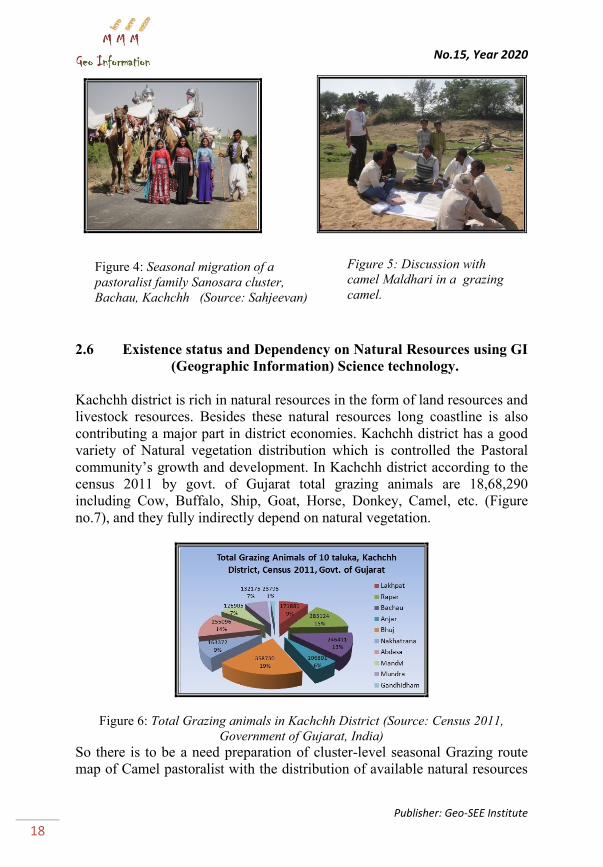
Monsoon, and Winter). As per the Pastoralist of this region we got the
information through focus group discussion (Figure no. 4) that basically
they roaming for grazing their camels in and around 25 km from the coast
line of the Arabian sea. So, we had taken the bench mark as 25 km buffer
Page 10
No.15, Year 2020
Publisher: Geo-SEE Institute
16
(Figure no. 9 and 10) from the coastline to identify the availability of
vegetation cover within that buffer zone specially with the help of Resource
Sat-2 LISS-III satellite imagery.
2.2 Data Details:
Satellite imageries:
For this Study Resource Sat-1 and 2, satellite data (2012 and 2017) have
been used for the identification of vegetation composition. The Resource
Sat-2 LISS-III satellite data of October 2012 and 12th December 2017,
collected from 'Sahjeevan' (NGO, Bhuj), and the rest of the data downloaded
for free of cost from NRSC (National Remote Sensing Centre) website,
Bhuvan portal, ISRO, Hyderabad of Govt. of India.
Data details are bellowed:
The Resource Sat-1 and 2 satellites have LISS-III sensor with 24 meters. of
Spatial Resolution, Spectral resolution of 4 bands (B2: 0.52-0.59, (green),
B3: 0.62-0.68 (red) B4: 0.77-0.86, (NIR) B5: 1.55-1.70 (SWIR) and the
swath of 141 km. For the cloud-free post-monsoon data December month
was selected. This data helped to identify the different natural objects of the
earth's surface such as land, waterbody, drainage, forest, mangrove species,
etc.
2.3 Processes for vegetation map ( Figure 2 ):
This section has been discussed some major step by step procedure (Figure
no. 2) for the preparation of two classified vegetation map of Kachchh
district, one is for whole Kachchh district and another is for 25 km. Buffer
zone from the coastline.
2.4 Processes for Cluster wise dependency map ( Figure 2 ):
This exercise is mainly developed by applying participatory methods defined
as manual GIS. For this exercise, ancillary data has been used and the
availability of natural vegetation along the grazing route had used the
satellite data. This exercise also follows some major steps to complete the
grazing route map. The major steps are defined in Figure no. 2.
2.5 Participatory Conservation Management plan through the GIS
tools.
A participatory conservation management plan is defined in this study to
manage the seasonal grazing route for the camel pastoralist. Camel
pastoralist Community (Figure no. 4 and 5) of the Kachchh region travels
throughout the year from one cluster to another cluster for grazing their
animals. The main objective of this study is to find out the natural vegetation
along the seasonal grazing route of the camel. In which cluster, what type of
Page 11
ISSN: 1857-9000, EISSN: 1857-9019
http://mmm-gi.geo-see.org
17
vegetation is available. How to manage pastoralists to decrease the
dependency of a specific cluster because there have some common clusters
where 3-4 groups of camel pastoralists gather in a single cluster for the
different seasons (Summer, Monsoon, and Winter).
Figure 2: Methodology for Coastal Diversity vegetation mapping for traditional
camel grazing routes.
Figure 3: Cross-checking with classified image, Kachchh District, Gujarat
Page 12
No.15, Year 2020
Publisher: Geo-SEE Institute
18
2.6 Existence status and Dependency on Natural Resources using GI
(Geographic Information) Science technology.
Kachchh district is rich in natural resources in the form of land resources and
livestock resources. Besides these natural resources long coastline is also
contributing a major part in district economies. Kachchh district has a good
variety of Natural vegetation distribution which is controlled the Pastoral
community’s growth and development. In Kachchh district according to the
census 2011 by govt. of Gujarat total grazing animals are 18,68,290
including Cow, Buffalo, Ship, Goat, Horse, Donkey, Camel, etc. (Figure
no.7), and they fully indirectly depend on natural vegetation.
Figure 6: Total Grazing animals in Kachchh District (Source: Census 2011,
Government of Gujarat, India)
So there is to be a need preparation of cluster-level seasonal Grazing route
map of Camel pastoralist with the distribution of available natural resources
Figure 4: Seasonal migration of a
pastoralist family Sanosara cluster,
Bachau, Kachchh (Source: Sahjeevan)
Figure 5: Discussion with
camel Maldhari in a grazing
camel.
Page 13
ISSN: 1857-9000, EISSN: 1857-9019
http://mmm-gi.geo-see.org
19
of the whole Kachchh region because when the pastoral community moves
around the Kachchh district for grazing they don’t have any idea regarding
the vegetation types. Once the natural resource map will prepare with
applying for the advance Remote sensing technology they can easily find out
in which area has what types of vegetation on their grazing route. This is
very difficult for a pastoralist to find out the actual grazing site or finalize
the seasonal grazing route in the whole Kachchh region. Taluka wise grazing
animal or livestock resource has been shown (Figure no.6 and 7).
Figure 7: Taluka wise Grazing Animal distribution in Kachchh (Source: Census
2011, Govt.of Gujarat)
3. RESULT AND DISCUSSION
3.1. Preparation of Natural Resource map of Kachchh district,
Gujarat.
Kachchh district broadly classified by four distinct regions i.e. (i) The Great
Rann, or uninhabited wasteland in the north (< 5 mt.), (ii) The Grassland of
Banni (5 to 10 mt), (iii) Main Land, consisting of planes, hills and dry river
beds (10 to 465 mt), (iv) The Coastline along the Arabian Sea in the south (0
to 12 mt). More loosely, the southern portion of the Rann is considered an
island, with seawater inundating the land for most of the year.
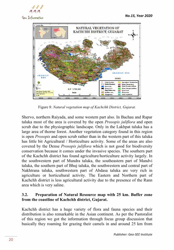
In this exercise, we have categories the vegetation type (Figure no. 8) into 8
broad categories (Dense thorn forest, Open Prosopis juliflora, Dense
Prosopis juliflora, open scrub, Grass cover, Mangroves, Saline vegetation,
and Agricultural crop/ Horticulture) with 5 other land use categories
(Waterbody, Mining area, High Saline area, and Mudflat area). Based on the
physiographic characteristic vegetation species also varied region to region.
In Bhuj taluka Banni region has a large amount of dense Prosopis juliflora
distribution in such panchayat as mota luna, Luna, southern Hodko, Northern
Page 14
No.15, Year 2020
Publisher: Geo-SEE Institute
20
Figure 8: Natural vegetation map of Kachchh District, Gujarat.
Shervo, northern Raiyada, and some western part also. In Bachau and Rapar
taluka most of the area is covered by the open Prosopis juliflora and open
scrub due to the physiographic landscape. Only in the Lakhpat taluka has a
large area of thorne forest. Another vegetation category found in this region
is open Prosopis and open scrub rather than in the western part of this taluka
has little bit Agricultural / Horticulture activity. Some of the areas are also
covered by the Dense Prosopis juliflora which is not good for biodiversity
conservation because it comes under the invasive species. The southern part
of the Kachchh district has found agriculture/horticulture activity largely. In
the southwestern part of Mundra taluka, the southeastern part of Mandvi
taluka, the southern part of Bhuj taluka, the southwestern and central part of
Nakhtrana taluka, southwestern part of Abdasa taluka are very rich in
agriculture or horticultural activity. The Eastern and Northern part of
Kachchh district is less agricultural activity due to the presence of the Rann
area which is very saline.
3.2. Preparation of Natural Resource map with 25 km. Buffer zone
from the coastline of Kachchh district, Gujarat.
Kachchh district has a huge variety of flora and fauna species and their
distribution is also remarkable in the Asian continent. As per the Pastoralist
of this region we got the information through focus group discussion that
basically they roaming for grazing their camels in and around 25 km from
Page 15
ISSN: 1857-9000, EISSN: 1857-9019
http://mmm-gi.geo-see.org
21
the coast line of the Arabian sea. So, we had taken the bench mark as 25 km
buffer from the coastline to identify the availability of vegetation cover
within that buffer zone specially with the help of Resource Sat-2 LISS-III
satellite imagery.
In this exercise, we have categories the vegetation type (Figure no. 9) into 8
broad categories as Land without scrub, Open Prosopis juliflora, Dense
Prosopis juliflora, open scrub (Acacia senegal, Acacia nilotica, Euphorbia,
Capparis decidua, Salvadora persica), Dense Mangroves (Avicennia
marina), Sparse Mangroves (Salvadora oleoides, Prosopis juliflora, Suaeda
sps.) and Agricultural land and crop/ Horticulture land with 5 other land use
categories (Builtup area, Limestone dominated area,
Figure 9: Natural vegetation map of Kachchh District, Gujarat
High saline area, inland water body, Salt pan, and Mudflat area). Based on
the physiographic characteristic vegetation species also varied region to
region. This map is showing the vegetation species distribution along the
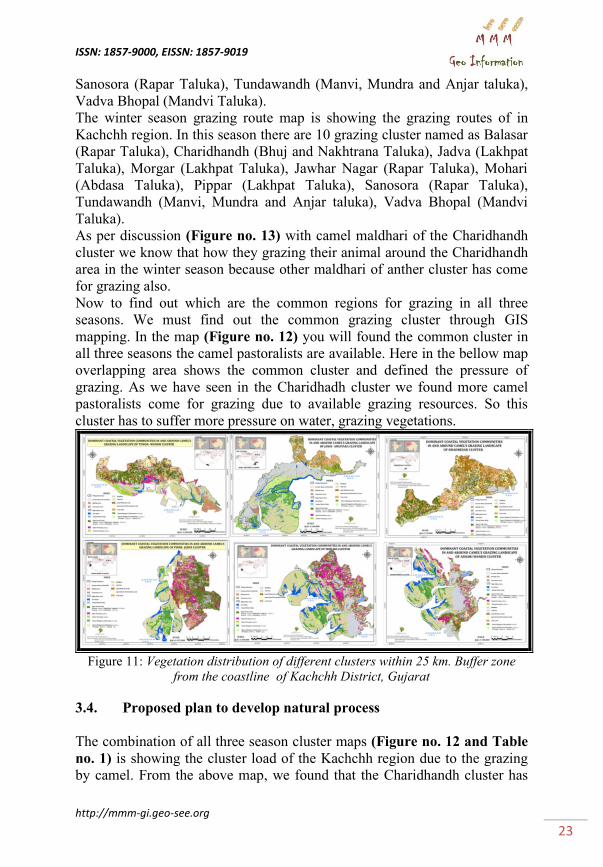
coastline. There are six clusters (Figure no. 10) located within the 25kms
buffer zone from the coastline of Kachchi district. They are (Figure no. 11)
Tundra wandh cluster, Jangi Amliyara cluster, Pipar Jadva cluster, Mohadi
cluster, Bhadresar cluster, and Ashari wandh cluster. The cluster-based
vegetation map is showing the composition of different types of vegetation
species with spatial location.
Page 16
No.15, Year 2020
Publisher: Geo-SEE Institute
22
Figure 10: Different cluster locations within 25 km. Buffer zone from the coastline
of Kachchh District, Gujarat
3.3. Preparation of Cluster level Seasonal Grazing Route Map of
camel pastoralist with the distribution of available Natural Resources.
Does this exercise have an important value that is according to the summer
route find out what type of vegetation is available on their grazing way?
From the (Figure no. 12) we can easily say the available vegetation type.
We can calculate the specific pressure of a cluster on it through how much
area it has and How many animal grazing there on a specific season. So in
this way, we can show the vegetation distribution and grazing pressure on
the summer route through the secondary animal data of a specific cluster.
We had identified their location by phone call and visit their location to
collect the information. This may not possible to realize their survival
process without staying with them. The Summer season grazing route map is
showing the grazing route direction of different cluster in summer season
(Table no. 1). There are 11 different cluster named as Balasar (Rapar
Taluka), Charidhandh (Bhuj and Nakhtrana Taluka), Jadva (Lakhpat
Taluka), Jangi (Bachau Taluka), Jawhar Nagar (Mandvi Taluka), Mohari
(Abdasa Taluka), Pachchham (Bhuj Taluka), Pippar (Lakhpat Taluka),
Page 17
ISSN: 1857-9000, EISSN: 1857-9019
http://mmm-gi.geo-see.org
23
Sanosora (Rapar Taluka), Tundawandh (Manvi, Mundra and Anjar taluka),
Vadva Bhopal (Mandvi Taluka).
The winter season grazing route map is showing the grazing routes of in
Kachchh region. In this season there are 10 grazing cluster named as Balasar
(Rapar Taluka), Charidhandh (Bhuj and Nakhtrana Taluka), Jadva (Lakhpat
Taluka), Morgar (Lakhpat Taluka), Jawhar Nagar (Rapar Taluka), Mohari
(Abdasa Taluka), Pippar (Lakhpat Taluka), Sanosora (Rapar Taluka),
Tundawandh (Manvi, Mundra and Anjar taluka), Vadva Bhopal (Mandvi
Taluka).
As per discussion (Figure no. 13) with camel maldhari of the Charidhandh
cluster we know that how they grazing their animal around the Charidhandh
area in the winter season because other maldhari of anther cluster has come
for grazing also.
Now to find out which are the common regions for grazing in all three
seasons. We must find out the common grazing cluster through GIS
mapping. In the map (Figure no. 12) you will found the common cluster in
all three seasons the camel pastoralists are available. Here in the bellow map
overlapping area shows the common cluster and defined the pressure of
grazing. As we have seen in the Charidhadh cluster we found more camel
pastoralists come for grazing due to available grazing resources. So this
cluster has to suffer more pressure on water, grazing vegetations.
Figure 11: Vegetation distribution of different clusters within 25 km. Buffer zone
from the coastline of Kachchh District, Gujarat
3.4. Proposed plan to develop natural process
The combination of all three season cluster maps (Figure no. 12 and Table
no. 1) is showing the cluster load of the Kachchh region due to the grazing
by camel. From the above map, we found that the Charidhandh cluster has
Page 18
No.15, Year 2020
Publisher: Geo-SEE Institute
24
the maximum load in the overall three seasons. This cluster is for the kachhi
camel pastoralist and this region is not suitable for monsoon season except
some agricultural places due to the waterlogging. From other cluster’s camel
Figure 12: Grazing routes of Camel Pastoralists in and around Kachchh District.
Table 1: Taluka wise seasonal Cluster distribution
pastoralists like Jangi,Jadva, Pachchham (in summer & winter) comes for
grazing in the Charidhandh cluster. In monsoon season only the Charidhandh
Page 19
ISSN: 1857-9000, EISSN: 1857-9019
http://mmm-gi.geo-see.org
25
cluster’s own Maldhari stay because this area is their residential area. In the
Pachchham cluster, only two season grazing is done summer and winter
season. There is no other cluster’s load. This cluster uses by the Kachchhi
camel pastoralist.
Figure 13: Camel pastoralist in winter grazing site, collection of information
through FGD (Focus Group Discussion)
Other low load clusters (Table no. 2) are Jangi, Mohari, Tundawandh, and
Jawhar Nagar. These all clusters are using by the Kharai camel pastoralists.
Kharai camel pastoralist travel along the coastline area means western
Kachchh.
Table 2: Description of cluster load in all season
Another heavy load cluster is Morgar cluster, here in all-season grass
available, here two more cluster’s Kachchhi camel pastoralists come for
Page 20
No.15, Year 2020
Publisher: Geo-SEE Institute
26
grazing their camel. The load has given weighted 7 after the Charidhandh
cluster (9). Except for this region, one more cluster has been used by the
Kachchi camel, Jadva cluster, and in this cluster one more cluster’s camel
pastoralist comes for grazing their camel. The load has given a weighted 6.
On the other way, only one cluster used by the Kachchi and kharai camel
pastoralist is Pippar and it has been used by other Kachchhi camel
pastoralists as from the Jadva cluster.
This cluster has a weighted of 6 (Table no. 2). Among the entire cluster, this
is clear that Charidhandh and Morgar cluster is to be needed more
consciousness regarding conservation and management. The other three
clusters also needed concentration for conservation and management as
Pippar, Jadva, and Balasar.
4. CONCLUSION
Participatory conservation management plan defined in this study to manage
the seasonal grazing route within the availability of vegetation for the camel
pastoralist. This study is impossible without including the pastoral
community. We heard from them about their problems during the seasonal
grazing and What kind of problem they have faced. They told us that
sometimes they do not get fresh drinking water due to the salinity then they
have to travel more kilometers for water. Camel pastoralist Community of
the Kachchh region travels throughout the year from one cluster to another
cluster for grazing their animals. The main objective of this study is to find
out the natural vegetation along the seasonal grazing route of the camel. In
which cluster what types of vegetation are available. How to manage
pastoralists to decrease a load of a specific cluster because there have some
common clusters where 3-4 groups of camel pastoralists gather in a cluster
in a different season (Summer, Monsoon, and Winter).
So, among all the clusters of this Kachchh region, Charidhandh and Morgar
cluster is to be needed more consciousness regarding conservation and
management. The other three clusters also needed concentration for
conservation and management as Pippar, Jadva, and Balasar.
5. ACKNOWLEDGEMENT
We are happy to say that without the cooperation of Sahjeevan and K-Link
team members this study will not succeed. The endowment has been
provided to purchase satellite imageries and for necessary field visits by the
Sahjeevan organization. We are thankful to Gujarat Ecological Education
and Research (GEER) Foundation, Gandhinagar, and Gujarat Institute of
Desert Ecology, Bhuj for their kind support to access their research reports
Page 21
ISSN: 1857-9000, EISSN: 1857-9019
http://mmm-gi.geo-see.org
27
and library. I am Thankful to my organization Gujarat University,
Ahmedabad, Gujarat,India for supporting me all over the time.
6. REFERENCES
1. AA. Alesheikh et al,.1997. Technologies and its Application.
ISPRS,Tehran ,Iran.
2. Belayneh, A., Asfaw, Z., Demissew, S., & Bussa, N. F. 2012. Medicinal
plants potential and use by pastoral and agro-pastoral communities in
Erer Valley of Babile Wereda, Eastern Ethiopia. Journal of
Ethnobiology and Ethnomedicine, 8(1), 42.
3. Dr.Dan Dvoskin et.al. 2003. Data Development Project in kutch Region.
Gujarat, India; Yanai Information Resources Ltd.
4. Das A., S. Shukla, P. Joshi, P. Prajapati. 2019. Wetland ecosystem
sustainability over human wildlife conflict in and around Lakhpat taluka,
Kachchh district, India. Thematics Journal of Geography, Volume 8, No
4, 2019, October (ISSN 2277-2995) page no. 414 to 427.
5. Das A., S. Shukla. 2019. Development Index of Kachchh District
reference to Gujarat State assembled with Census Data and Geospatial
Technology. Gujarat University Journal, Vidya (March, 2019) Vol. No :
ISSN: 2321-1520, page no. 80-97.
6. GEER, GUIDE. 2001. Ecological status of Narayan Sarovar Wildlife
Sanctuary with a management perspective. Final Report. Gujarat
Ecological Education and Research (GEER) Foundation, Gandhinagar
and Gujarat Institute of Desert Ecology, Bhuj; 1- 196.
7. GUIDE. 2004. Vegetation cover mapping of Banni grassland using
remote sensing. Gujarat Institute of Desert Ecology”, Report, Bhuj; 1-
24.
8. GUIDE. 1998. “Status of Banni grassland and exigency of restoration
efforts”. Gujarat Institute of Desert Ecology (GUIDE), Bhuj (Kachchh).
Report; 1-60.
9. GUIDE, 2009. An Integrated Grassland Development in Banni ,
Kachchh District, Gujarat State. Progress Report. Gujarat Institute of
desert Ecology (GUIDE); 1-15.
10. Emadi, M. H. 2012. Better Land Stewardship to Avert Poverty and Land
Degradation: A Viewpoint from Afghanistan. In Rangeland Stewardship
in Central Asia, Springer. pp. 91–108.
11. Garcia, K. B., Malabrigo Jr, P. L., & Gevaña, D. T. 2014. Philippines’
Mangrove Ecosystem: Status, Threats and Conservation. In Mangrove
Ecosystems of Asia, Springer. pp. 81–94.
Page 22
No.15, Year 2020
Publisher: Geo-SEE Institute
28
12. Hartter, J., Stampone, M. D., Ryan, S. J., Kirner, K., Chapman, C. A., &
Goldman, A. 2012. Patterns and perceptions of climate change in a
biodiversity conservation hotspot. PloS One, e32408, 7(2).
13. Joshi P. N et al, 2009. “Local perceptions of grassland change and
priorities for conservation of natural resources of Banni, Gujarat, India”.
Journal of Front. Biol. China.; 1-8.
14. Kandasamy, K. 2017. Mangroves in India and Climate Change: An
Overview. In Participatory Mangrove Management in a Changing
Climate, Springer, pp. 31–57.
15. Kandasamy, K. 2017. Mangroves in India and Climate Change: An
Overview. In Participatory Mangrove Management in a Changing
Climate Springer, pp. 31–57.
16. Lynch, A. J. J., Kalumanga, E., & Ospina, G. A. 2016. Socio-ecological
aspects of sustaining Ramsar wetlands in three biodiverse developing
countries. Marine and Freshwater Research, 67(6), 850–868.
17. Muzirambi, J. M., & Mearns, K. F. 2015. Active community
participation in nature conservation and tourism management: A case
study analysis of the state of power relations in Southern Africa. The
Environment People Nexus in Sustainable Tourism: Finding the
Balance, 35.
18. Nkambule, S. S., Buthelezi, H. Z., & Munien, S. 2016. Opportunities
and constraints for community-based conservation: The case of the
KwaZulu-Natal Sandstone Sourveld grassland, South Africa. Bothalia,
46(2), 8–pages.
19. Nkambule, S. S., Buthelezi, H. Z., & Munien, S. 2016. Opportunities
and constraints for community-based conservation: The case of the
KwaZulu-Natal Sandstone Sourveld grassland, South Africa. Bothalia,
46(2), 8–pages.
20. Patel Y. S. 2010. “Herbaceous Biomass Productivity of Banni
Grassland, Kachchh, Gujarat”. Science Excellence, Organized by
Gujarat Uni. Ahmadabad and Gujarat Council on Science and
Technology, Gandhinagar; BOP1.
21. Pittock, J., Finlayson, M., Arthington, A., Roux, D., Matthews, J., Biggs,
H. Froend, R. 2015. Managing freshwater, river, wetland and estuarine
protected areas. Protected Area Governance and Management, 569–608.
22. Rahmani AR. 1997. “A study on the ecology of grasslands of the Indian
Plains with particular reference to their endangered fauna”. Final
Report. Bombay Natural history Society, Mumbai; 1- 549.
23. Roden, P., Bergmann, C., Ulrich, A., & Nüsser, M. 2016a. Tracing
divergent livelihood pathways in the drylands: A perspective on two
spatially proximate locations in Laikipia County, Kenya. Journal of Arid
Environments, 124, 239–248.
Page 23
ISSN: 1857-9000, EISSN: 1857-9019
http://mmm-gi.geo-see.org
29
24. Roden, P., Bergmann, C., Ulrich, A., & Nüsser, M. 2016b. Tracing
divergent livelihood pathways in the drylands: A perspective on two
spatially proximate locations in Laikipia County, Kenya. Journal of Arid
Environments, 124, 239–248.
25. Satyanarayana, B., Mulder, S., Jayatissa, L. P., & Dahdouh-Guebas, F.
2013. Are the mangroves in the Galle-Unawatuna area (Sri Lanka) at
risk? A social-ecological approach involving local stakeholders for a
better conservation policy. Ocean & Coastal Management, 71, 225–237.
26. Singh, R. K., Singh, A., & Pandey, C. 2014. Agro-biodiversity in rice-
wheat-based agroecosystems of eastern Uttar Pradesh, India:
implications for conservation and sustainable management. International
Journal of Sustainable Development & World Ecology, 21(1), 46–59.