Comprehensive Implementation Plan Executive Summary “Trails have multiple values and their benefits reach far beyond recreation. Trails can enrich the quality of life for individuals, make communities more livable, and protect, nuture, and showcase America’s grandeur by traversing areas of natural beauty, distinctive geography, historic significance, and ecological diversity. Trails are important for the nation’s health, economy, resource protection and education.” –AMERICAN TRAILS, Trails for All Americans report, 1990
“Trails have multiple values and their benefits reach far beyond recreation.
Trails can enrich the quality of life for individuals, make communities more livable, and protect, nuture,
and showcase America’s grandeur by traversing areas of natural beauty, distinctive geography, historic
significance, and ecological diversity. Trails are important for
the nation’s health, economy, resource protection and education.”
–AMERICAN TRAILS, Trails for All Americans report, 1990
Colorado Front Range Trail Comprehensive Implementation Plan Executive Summary
1
CFRT COMPREHENSIVE IMPLEMENTATION PLAN EXECUTIVE SUMMARY
OVERVIEW The purpose of this planning effort is to develop a five-year Colorado Front Range Trail (CFRT) Comprehensive Implementation Plan (CFRT Plan) for Colorado State Parks (State Parks). The CFRT Plan includes a detailed assessment of existing trail segments along Colorado’s Front Range, as well as marketing and financial strategies to facilitate completion of the CFRT. Important steps in the year-long planning process included collecting data, developing a comprehensive database and Geographic Information Systems (GIS) coverages, and establishing a framework to identify trail construction priorities. The CFRT Plan is intended to be implemented through collaborative efforts between State Parks and the CFRT Development Council. The information and recommendations in the plan should serve as a resource and guide not only for State Parks, but also for members of the CFRT Development Council and local stakeholders. The success of the CFRT development and promotion is dependent on the cooperation between all agencies and stakeholders. Pertinent information related to the completion of the trail should be updated every two years. Tracking the progression of segments from “envisioned” to “planned,” as well as identifying new or revised alignments and loops are critical to monitoring the completion of the trail. The CFRT Service Area The Front Range serves as the primary service area for this analysis and includes 14 counties, 15 major cities, and many smaller towns and communities. Colorado’s Front Range closely follows the eastern fringe of the Rocky Mountains in a north-south direction from Wyoming to New Mexico. The CFRT serves over 80% of Colorado’s population and runs through some of the most rapidly growing communities in the state. INVENTORY AND ASSESSMENT OF THE CFRT SYSTEM Stakeholder Identification and Involvement During 2005-2006, Colorado State Parks worked with over 500 stakeholders from local communities, state and federal agencies, non-profit organizations, recreation retailers, and the tourism community to continue the collaborative efforts necessary to complete the CFRT. The Consultant Team solicited feedback from all of the 35 managing agencies involved in the trail through a survey; 29 of those agencies responded. (Managing agencies are defined as land management agencies through which the CFRT passes and whom are responsible for overseeing the planning, construction, and maintenance of the trail). The stakeholder involvement process occurred over a five-month period through in-depth interviews and reviews of maps that identified completed, planned, and envisioned trail segments. This information was compiled into the CFRT Inventory and Assessment Database (Database) and was also used to identify the CFRT Priority Segments.
Colorado Front Range Trail Comprehensive Implementation Plan Executive Summary
2
Inventory Findings Currently, there are 35 managing agencies responsible for overseeing the construction, operation, and maintenance of completed, planned, and envisioned segments of the CFRT. Of those 35 agencies, 29 responded to the survey conducted by the Consultant Team including the federal government, two state agencies, seven county governments, 16 municipal governments, and three private non-profit organizations. At the time of this inventory, 67% of the trail is paved (primarily with concrete), 28% is soft surface, and 4% is of unknown surface type. The majority of planned and envisioned trails are hard surface - primarily concrete. Approximately 56% of the existing trail, or 164 miles, is known to be Americans with Disabilities Act (ADA) accessible. Table 1 depicts the highest priority recommendations related to the inventory and assessment process. The priority level associated with each recommendation indicates the urgency for implementation and was determined by the Consultant Team, based on information gathered from the Project Team and the Development Council.
Table 1: CFRT Inventory and Assessment Recommendations
Recommendations Priority (High, Medium, Low)
Update the inventory every two years High
Track volunteer hours for trail development and maintenance High
Track location and managing agency of newly placed CFRT signs High
Work with the Development Council to identify managing agencies to take responsibility for “undetermined” CFRT segments High
CFRT Inventory Findings
• 295 Miles of Completed Trail (34% of the Total Trail)
• 93 Miles of Planned Trail (11%) • 488 Miles of Envisioned Trail (55%) • 877 Total Miles of Trail • 110 Trailheads
Colorado Front Range Trail Comprehensive Implementation Plan Executive Summary
3
CFRT PRIORITIZATION PLAN Priority Segment Findings Approximately 170 miles of trail represented in 63 sections have been designated as Priority Segments. These 63 Priority Segments have been deemed critical to complete because they are the essential missing links that will connect the major cities and population centers along the CFRT corridor including: Ft. Collins, Loveland, Boulder, Denver, Colorado Springs, and Pueblo. Table 3 identifies details of each CFRT Priority Segment while Figures 1, 2, and 3 illustrate the Priority Segments on maps of the CFRT North, Middle, and South Sections. Of the 35 managing agencies involved with the CFRT, 26 of these oversee the planning, construction, and maintenance of Priority Segments. (Adams County manages segments in both the North and Middle Sections, and therefore is only counted once in the number of agencies overseeing Priority Segments). These Priority Segments represent nearly one-third of the total miles of planned and envisioned segments of the CFRT. Approximately 80 miles, or 47%, of the Priority Segments are considered to be in the planning stages with estimated completion dates. Priority Segments were determined in collaboration with the CFRT Development Council, CFRT Steering Committee, and the Colorado State Parks Board. Stakeholder input clearly indicates that connecting existing trails is the most critical criteria for prioritizing trail construction and grant funding. These Priority Segments reflect the CFRT Development Council’s highest priorities for allocation of funding: to strategically locate missing links, maximize quality of life benefits, and serve the maximum population.
Table 2: CFRT Prioritization Plan Recommendations
CFRT Prioritization Plan Recommendations Priority (High, Medium, Low) Work with the managing authorities to determine estimated completion dates, barriers to completion, and funding sources for all Priority Segments
High
Enhanced Grant Evaluation Process for CFRT Trail Segments As part of the CFRT Plan, the Consulting Team developed an enhanced Colorado State Trails Program Grant Evaluation Process. CFRT grants will now be evaluated within their own separate category and will only compete with other CFRT grants. Priority Segments by Section Priority Segments in the North Section of the CFRT, as depicted in Figure 1, include about 108 miles of trail, or 67% of the total miles of Priority Segments, which will connect and maximize the use of existing facilities. When these Priority Segments are completed, they will add another 12% to the total mileage of the CFRT. There are 16 agencies responsible for managing these segments and are located primarily in developed areas. Weld County, Larimer County, and The Northern Colorado Water Conservancy District are the managing authorities for the most significant lengths of trail. There are two major barriers to completion in the North Section: acquisition or negotiation of easements and a lack of adequate funding.
Colorado Front Range Trail Comprehensive Implementation Plan Executive Summary
4
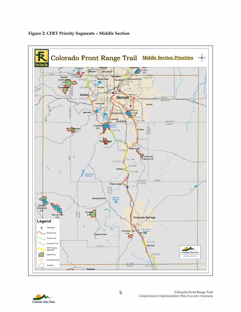
The Middle Section priorities, as depicted in Figure 2, are primarily short segments that will serve as connectors to the existing trail network. This section has about 42 miles of 18 Priority Segments that involve nine managing agencies. When completed, these segments would add another 5% to the total miles of the CFRT. Estimated completion dates and projected construction costs are identified for the majority of these segments, including the pieces from the south Boulder County line to Golden, Brighton to Confluence Park, and from Castle Rock to the north El Paso County line. A few of the barriers to completion in the Middle Section include wildlife concerns, developer issues, environmental issues, and highway planning options. The South Section has three Priority Segments totaling approximately 20 miles, as depicted in Figure 3, which are managed by two agencies. When completed, these segments will add another 2% to the total miles of the CFRT. Both of the planned sections are managed by the City of Pueblo while Pueblo County manages the 13 mile envisioned portion. No barriers to completion were identified.
Figure 1: CFRT Priority Segments – North Section
Colorado Front Range Trail Comprehensive Implementation Plan Executive Summary
5
Figure 2: CFRT Priority Segments – Middle Section
.
Colorado Front Range Trail Comprehensive Implementation Plan Executive Summary
6
Figure 3: CFRT Priority Segments – South Section
Colorado Front Range Trail Comprehensive Implementation Plan Executive Summary
7
Table 3: CFRT Priority Segments (Arranged by Section and Managing Authority)* *Managing authority may change as more information is obtained. Information is best available at the time of publication.
Section along Salvia St. linking Grampsas Trail and Clear Creek Trail
0.26 Paved Planned
Total 0.26
UU Middle Section Undetermined Golden
Section along CR 93 linking Clear Creek Trail and 6th Ave. Trail
0.85 Concrete Planned
Total 1.11
PP Middle Section Undetermined Jefferson County From county line running
south along CR 93 to route 72 3.05 Concrete Planned
SS Middle Section Undetermined Jefferson County
Section running south from Arvada city limits to the Fairmont Trail
2.24 Concrete Planned
Total 5.29
DDD Middle Section Undetermined Larkspur East side of Larkspur along
Plum Creek 0.56 Natural Envisioned
Total 0.56 Total for the Middle Section 42.21
III South Section Undetermined City of Pueblo
From Pueblo city limits to existing Fountain Creek Regional Trail
1.48 Concrete Planned
JJJ South Section Undetermined City of Pueblo
From Arkansas River Walk Trail on east side of Pueblo State Park heading south to Route 78
4.63 Concrete Planned
Total 6.12
HHH South Section Undetermined Pueblo County
From Pueblo/El Paso county line running south along Fountain Creek to Pueblo city limits
13.39 Undetermined Envisioned
Total 13.39 Total for the South Section 19.51 TOTAL CFRT PRIORITY SEGMENTS 170.20
Colorado Front Range Trail Complementation Plan Executive Summary
14
CFRT MARKETING PLAN The CFRT Marketing Plan analyzes the market demands and preferences of current and potential trail users. This analysis segments the market by age, trail and recreation type, and use frequency. The CFRT Marketing Plan also: 1) contains an analysis that estimates the economic impact of CFRT development over the next 25 years; 2) identifies potential marketing targets, strategies, and partners to help develop and promote the trail for Colorado State Parks and the CFRT Development Council; 3) includes key goals and objectives of the plan and recommended evaluation tools; and 4) projects marketing costs outlined for the 2006-2010 timeframe. Colorado Front Range Trail Economic Impact The total direct economic impact to the 14 counties along the CFRT ranges from approximately $1.3 to $2.0 billion over the next 25 years. The calculations used to determine the economic impacts of the CFRT are based on a 2003 Colorado State Parks Market Assessment Study which states that 74% of Colorado households use trails at least once a year in their town or city. As part of the total direct economic impact calculation, this percent is multiplied by individual county population projections from the Colorado Demography Office to come up with projected trail use. Finally, trail use calculations are multiplied by the annual spending estimates to generate the total economic impact (from an annual low of $18.46/household to a high of $29.23/household, based on A Contingent Trip Model for Estimating Rail-Trail Demand, and then discounted at a 5% rate to account for inflation). Table 4 depicts major recommendations from the CFRT Marketing Plan for Colorado State Parks for 2006-2010. The priority level associated with each recommendation indicates the urgency for implementation and was determined by the Consultant Team, based on information gathered from the Project Team and the Development Council.
Table 4: CFRT Marketing Plan Recommendations
CFRT Marketing Plan Recommendations Priority (High, Medium, Low)
Allocate funding as outlined in the CFRT Marketing Plan Budget for 2006-2010 High Continue to implement the CFRT marketing strategies already in place High Develop and administer a CFRT user survey to establish direct economic impacts and spending High
Encourage local managing agencies to use the economic impacts and additional benefits of the CFRT detailed in the plan to gain local support and alternative funding High Implement a CFRT retail and print media marketing campaign High Market to growth “hot spots” High Track Colorado trail activity demands and trends- support “trail counters” at the local level High Annually update economic development benchmarking communities High Update demographic and population numbers every two years High Promote visibility of CFRT through signage High
Colorado Front Range Trail Complementation Plan Executive Summary
15
CFRT Marketing Plan Recommendations Priority (High, Medium, Low)
Coordinate state, national and international efforts with the Colorado Tourism Office High Annually track implementation and effectiveness of the plan using the goals, objectives, and evaluation criteria implementation High Share economic impact calculations and benefits with CFRT Development Council High Continue to gather economic impact data for various CFRT trail-related activities Medium
Track locations and managing agencies of newly place CFRT signs Medium Identify cost-effective marketing opportunities to promote specific trail segments Medium
Strategically implement additional, cost-effective strategies in the plan Medium Strategically market to adults 55 and older Medium
CFRT FINANCIAL STRATEGY The CFRT Financial Strategy examines estimated costs, historical and current funding, allocation strategies, and funding alternatives. These financial components are critical to the successful implementation of the CFRT. While the majority of the CFRT has been historically funded through Colorado State Trails Program grants and managing agency budgets, additional funding strategies must be pursued due to declining Land and Water Conservation Fund (LWCF) appropriations. Administrative recommendations are also identified to maximize both financial and human resources and assist with the management and organization of the project. The total estimated cost of constructing the 877 miles of the CFRT is approximately $273 million, based on 2006 dollars as shown in Tables 32-37. Approximately $79 million has already been devoted to building the existing 295 miles of the CFRT. Completing the remaining 581 planned and envisioned miles is expected to cost $157 million (sum of totals in Table 36 and 37). Constructing the 170 miles of Priority Segments will cost between $36.8 and $46.7 million or between $7.4 and $9.4 annually through 2010. The anticipated annual operation and maintenance cost of the entire CFRT is expected to cost between $5.3 and $8.8 million. Successful implementation of the CFRT Plan will require commitment from the Colorado State Parks Board to establish internal, dedicated CFRT staffing and funding resources. These staff members and resources should be solely focused on implementing the recommendations in the CFRT Plan and supporting managing agencies in local planning and development of the trail. This commitment, as well as continued administrative and financial transparency, will illustrate State Parks’ leadership and credibility to potential funders and the CFRT Development Council. Another element for the successful implementation of the CFRT Plan is the continued engagement of the CFRT Development Council. The Council indicated its interest in decreasing the Quarterly meetings to Semi-annual meetings for 2007. This should be evaluated at the second meeting in 2007 for future years.
Colorado Front Range Trail Complementation Plan Executive Summary
16
Table 5 depicts major recommendations included in the CFRT Financial Strategy. The priority level associated with each recommendation indicates the urgency for implementation and was determined by the Consultant Team, based on information gathered from the Project Team and the Development Council.
Grant Allocation Strategies Create a CFRT grant category in the Colorado State Trails Program High Determine an appropriate percentage of Colorado State Trails Program grants to allocate to CFRT projects High Alternative Funding Strategies Develop a CFRT Funding Task Force High Form a CFRT Foundation or collaborate with the Foundation for Colorado State Parks to:
• Conduct a capital campaign using the Colorado State Trails Program database and targeting relevant user groups
• Consider participating in the Colorado Combined Campaign or other workplace giving programs
• Offer CFRT merchandise High Pursue a federal earmark High Apply for another GOCO Legacy Grant High Pursue alternative funding sources for the Colorado State Trails Program High Consider incorporating advertisements into CFRT publications and the website Medium Investigate event sponsorship prospects Medium Explore cooperative marketing partnership opportunities Medium Continue to seek out and share additional alternative funding sources with the Development Council Medium Administrative Recommendations Enhance financial tracking and analysis abilities with a comprehensive Colorado State Trails Program database High Create a CFRT Local Planning and Trail Development Guide for local governments including funding opportunities such as:
• a list of potential grant opportunities for managing agencies • a hotel bed tax/tourism tax • a dedicated portion of the local government’s sales tax to parks, trails, and open
space • using volunteers, youth groups, and prison work or community service
programs • working with collaborative partners High
Continue the appointment of a liaison between the State Trails Committee and the CFRT High Work with the National Park Service Scenic Rivers & Trails Conservation Assistance Program to support managing agencies with planning and implementation efforts Medium