1 ________________________________________________________ COMPREHENSIVE TOWN PLAN FOR THE TOWN OF BENSON, VERMONT ________________________________________________________ www.bensonvt.com Benson Selectboard Benson Planning Commission Adopted December 4, 2017
TABLE OF CONTENTS ........................................................................................................ 2
INTRODUCTION ................................................................................................................ 5 Purpose .............................................................................................................................................................................. 5 Statutory Authority and Requirements .............................................................................................................................. 5 Preparation of the Plan ...................................................................................................................................................... 6 Hearings and Public Participation ...................................................................................................................................... 6
BENSON: PAST, PRESENT AND FUTURE .......................................................................... 6 Location .............................................................................................................................................................................. 6 History of Benson ............................................................................................................................................................... 6 Present Community Profile ................................................................................................................................................ 7 Goals of the Town of Benson ........................................................................................................................................... 10
COMMUNITY FACILITIES AND SERVICES .......................................................................11 Benson Town Office ......................................................................................................................................................... 11 Benson Free Library.......................................................................................................................................................... 11 Community Hall ................................................................................................................................................................ 12 Post Office ........................................................................................................................................................................ 12 Child Care ......................................................................................................................................................................... 12 Health Services ................................................................................................................................................................. 13 Rescue Services ................................................................................................................................................................ 13 Emergency Management ................................................................................................................................................. 13 Public Safety & Police ....................................................................................................................................................... 14 Fire Protection .................................................................................................................................................................. 14 Benson Highway Department Building ............................................................................................................................ 15 Telephone and Television Services .................................................................................................................................. 15 Wireless Telecommunications Facilities........................................................................................................................... 15 Wastewater Treatment Facility ........................................................................................................................................ 15 Water Supply .................................................................................................................................................................... 16 Solid Waste Disposal ........................................................................................................................................................ 16 Facility Needs and Improvements .................................................................................................................................... 17
ENERGY ...........................................................................................................................17 Energy Goals, Policies and Programs ............................................................................................................................... 24
EDUCATION ....................................................................................................................39 Suggested School Administration Education Goals, Policies and Programs .................................................................... 40
NATURAL RESOURCES ...................................................................................................40 Climate, Topography, & Geology ..................................................................................................................................... 41 Agriculture, Forestry and Mineral Resources ................................................................................................................... 41 Water Resources .............................................................................................................................................................. 42 Watersheds ...................................................................................................................................................................... 42 Surface Water .................................................................................................................................................................. 42 Ground Water .................................................................................................................................................................. 43 Threats to Water Quality .................................................................................................................................................. 43 Wetlands .......................................................................................................................................................................... 43 Water Resource Protection .............................................................................................................................................. 44 Flood Resilience................................................................................................................................................................ 44 Wildlife Habitats and Fragile Areas .................................................................................................................................. 46 Forest Fragmentation…………………………………………………………………………………………………………………………………………........47 Open Space and Scenic Resources ................................................................................................................................... 47 Conservation Commission ................................................................................................................................................ 48 Natural Resources Goals, Policies and Programs ............................................................................................................. 48
3
RECREATION ...................................................................................................................49 Recreation Facilities ......................................................................................................................................................... 49 Lake Recreational Accesses .............................................................................................................................................. 50 Recreational Organizations .............................................................................................................................................. 51 Benson Village Center Recreation Facilities ..................................................................................................................... 51 Recreation Goals, Policies and Programs ......................................................................................................................... 51
HISTORIC AND CULTURAL RESOURCES .........................................................................52 Historic Resources ............................................................................................................................................................ 52 Historic Commission ......................................................................................................................................................... 53 Cultural Resources............................................................................................................................................................ 53 Monument to Veterans .................................................................................................................................................... 53 Churches ........................................................................................................................................................................... 53 Cemeteries ....................................................................................................................................................................... 53 Historic and Cultural Resources Goals, Policies and Programs ........................................................................................ 54
TRANSPORTATION .........................................................................................................58 Benson’s Highway System ................................................................................................................................................ 59 Other Modes of Transportation ....................................................................................................................................... 60 Highway Department ....................................................................................................................................................... 61 Funding ............................................................................................................................................................................. 61 Infrastructure Inventory ................................................................................................................................................... 61 Transportation Goals, Policies and Programs .................................................................................................................. 61
ECONOMIC DEVELOPMENT ...........................................................................................62 Village Area ...................................................................................................................................................................... 62 Commercial and Employment Activity in Benson ............................................................................................................ 63 Unemployment Rate ........................................................................................................................................................ 65 Economic Development Goals, Policies and Programs .................................................................................................... 66 Green Mountain Council Exemption from Taxation ........................................................................................................ 67
LAND USE AND GROWTH ...............................................................................................67 Existing Conditions ........................................................................................................................................................... 67 Conserved Land ................................................................................................................................................................ 68 Future Direction of Benson Land Uses ............................................................................................................................. 68 Land Use Districts ............................................................................................................................................................. 69 Land Use and Growth Goals, Policies and Programs ........................................................................................................ 70
MUNICIPAL AND REGIONAL COORDINATION ...............................................................71
Table 1: Population Growth…………………………………………………………………………….……………………………………………………………….8 Table 2: Population by Age…………………………………………………………………………………………………………………………………………… ..9 Table 3: Median Age…………………………………………………………………………………………………………………………………………………….….9 Table 4: Number of Households……………………………………………………………………………………………………………………………………..10 Table 5: Average Household Size……………………………………………………………………………………………………………………………………10 Table 6: Benson Community Survey……………………………………………………………………………………………………………………………….37 Table 7: Existing 911 Structures in the Mapped Flood Hazard Areas………………………………………………………………………………46 Table 8: Benson Grand List 2002-2016……………………………………………………………………………………………………………………………55 Table 9: Grand List Assessed Values 2002-2016……………………………………………………………………………………………………………..55 Table 10: Housing Units by Type, Occupancy and Tenure……………………………………………………………………………………………….56 Table 11: Average Household Size (same as Table 5) ……………………………………………………………………………………………………..56 Table 12: Housing Units by Owner / Renter Occupied…………………………………………………………………………………………………….57 Table 13: Trends in Employment and Economic Development……………………………………………………………………………………….63 Table 14: 2015 Household Income………………………………………………………………………………………………………………………………….65 Table 15: Unemployment Rate……………………………………………………………………………………………………………………………………….65 Table 16: Benson Grand List 2002-2016 (same as Table 8)……………………………………………………………………………………………..68 Figure 1: A generic depiction showing how the Special Flood Hazard Area differs from the River Corridor………………..…..45 Figure 2: U.S. Census Worker Inflow-Outflow Analysis, 2014………………………………………………………………………………………….64 Map 1: Solar Resources………………………………………………………………………………………………………………………………………………….29 Map 2: Wind Resources………………………………………………………………………………………………………………………………………………….30 Map 3: Hydroelectric Resources……………………………………………………………………………………………………………………………………..31 Map 4: Biomass Resources……………………………………………………………………………………………………………………………………………..32 Map 5: Existing Renewable Generation………………………………………………………………………………………………………………………….32 Map 6: Local Constraint Areas and Preferred Areas…………………………………………….………………………………………………..……….34 Map 7: Green Mountain Power Solar Map……………………………………………………………………………………………………………………..35 Map 8: Future Land Use………………………………………………………………………………………………………………………………………………….72 Map 9: Education and Community Facilities…………………………………………………………………………………… ………………………73 Map 10: Transportation……………………………………………………………………………………………………………………………………………… ..74 Map 11: Natural Resources 1………………………………………………………………………………………………………………………………………….75 Map 12: Natural Resources 2………………………………………………………………………………………………………………………………………….76 Map 13: Natural Resources 3………………………………………………………………………………………………………………………………………….77
5
INTRODUCTION
Purpose
In 1972 the Selectboard of the Town of Benson ("Benson" or the "Town") established the
Benson Planning Commission (the "Commission"). The Commission consists of seven members
appointed by the Selectboard. The Commission was directed to develop a comprehensive plan to
help direct the future growth and development of Benson (the "Plan").
In June of 1988, the Commission drafted its first Town Plan, which was adopted by the
Selectboard. That Plan represented substantial effort by the Commission and substantial
involvement by the community. At that time, the Town wanted to encourage certain types of
growth, at an appropriate rate, such as single-family homes, vacation homes, agricultural activities,
small business, light industry, and professional educational and health services. The 1998 Town
Plan was built on the work done to develop that first Plan. The 1998 plan was adopted by the
Selectboard and was amended in 1999 in order for the Town to obtain Rutland Regional Planning
Commission (RRPC) approval. In 2004, the Town Plan was revised by the Planning Commission; the
new Plan was adopted by the Selectboard and approved by the RRPC. The Plan was revised again in
2008, adopted by the Selectboard and approved by the RRPC. The Plan was most recently revised in
2013.
Statutory Authority and Requirements
Implementation of the Municipal Plan is a local responsibility and can only be accomplished
by following the provisions for adoption, maintenance and implementation as provided for in the
Vermont Planning and Development Act: Chapter 117 of Title 24, Vermont Statutes Annotated (the
Act). This section of law specifies not only what a Plan may or must contain, it also specifies how a
Plan must be adopted.
It is important to understand that a Town Plan is not a zoning ordinance. The Town Plan has
many uses, such as outlining areas of community concern and priorities requiring attention. It also
can help the Town or other organizations in the Town attain funding and support for activities that
the Plan has listed as having support in the community. A Town Plan also allows the Town to
express its voice in state land use permitting proceedings. The Town Plan is the basis for the zoning
and subdivision ordinance and other land use ordinances. Any such ordinances are based on the
goals set forth in the Plan. The 2008 Plan made minor adjustments to the 2004 Plan for consistency
with recently adopted zoning and subdivision bylaws and updated data and statistics. The 2013 Plan
is an update of the 2008 Plan and includes 2010 Census Data. The goals and objectives of the
previous Plan are consistent with this new Plan. Two new sections have been added and the energy
section expanded to cover the siting of renewable energy generation facilities and include Town
priorities, policies and goals which will assist with meeting the state goal of 90% renewable energy
by 2050.
6
Preparation of the Plan
In preparation of this revision to the Town Plan, the Planning Commission has consulted the Act, the relevant census data, Rutland Regional Planning Commission (RRPC) information, the Vermont Statute’s revised requirements for Town Plans, and Town land records and maps. The State Statutes have listed 12 elements that must be addressed in a Town plan to obtain approval by RRPC. They are: a statement of the objectives, policies and programs; a land use plan and map that include forest blocks and habitat connectors and plans for land development to minimize forest fragmentation; a transportation plan and map; a utility and facility plan and map; a statement of policies on the preservation of rare and irreplaceable natural areas, scenic and historic features and resources; an educational facilities plan and map; a recommended program for the implementation of the objectives; a statement indicating how the plan relates to development trends and plans for adjacent municipalities, areas, and the region; an energy plan; an economic development element, a flood resilience element; and a housing element including a program for addressing low and moderate income persons’ housing needs. State statutes also list 14 statewide planning goals that this plan should address.
Hearings and Public Participation
The process of adopting the Town Plan has several steps: The Planning Commission holds a public meeting and warns and holds a public hearing, followed by a vote after incorporating any changes to the plan. Then the plan is sent to the Selectboard. The Selectboard warns a hearing, and after the hearing, adopts the Town Plan after making any required changes.
This is an update of a previously approved Town Plan without significant changes in goals or
objectives. Data and information have been updated, the energy section expanded and two new sections: (1) forest fragmentation, wildlife habitat and wildlife corridors and (2) flood resilience added. There was extensive citizen participation in developing the 2004 plan and the land use regulations which involved numerous public meetings and newsletter articles. Public participation in the update has been invited through a survey, the newsletter, planning commission meetings, a public informational meeting and the hearings. There were 100 responses to the mailed survey; questions and results are in included in the energy section of the plan.
BENSON: PAST, PRESENT AND FUTURE Location
Benson is a small Town in the northwestern corner of Rutland County. It is bounded on the west by Lake Champlain, which separates Vermont from New York. It is bounded on the North by Orwell, which is the Addison-Rutland county line; bounded on the east by Sudbury, Hubbardton, and Castleton; and on the South by West Haven and Fair Haven. The Town covers an area of 45.6 square miles (29,210 acres). History of Benson
Historically, Benson was a farming community. Our Town Charter was signed on May 5,
1780 and by 1790 the village was a prospering market center. The Town was supported in part by
7
traffic and trade that traveled on the Whitehall to Vergennes Stage Road (Stage Road) and the road
to the lake and Benson Landing (Lake Road).
The importance of Benson Landing increased after the completion of the Champlain Canal.
The canal connects Lake Champlain with the Hudson River. Benson Landing served as an access to
the lake and connected the Town to lucrative markets that used Champlain to transport goods.
Farmers were close to the source of transportation and their goods didn’t have to travel as far by
land thus putting them at an advantage. In the early nineteenth century, Benson was home to
many profitable sheep farms. Wool traveled by way of Lake Champlain and the Hudson River to the
markets of New York.
Traffic was diverted from the Village and the Stage Road when the Fair Haven Turnpike, now
Route 22A, was completed in 1810. By the 1840's sheep farming had reached its peak of prosperity.
Lowering of tariffs for Australian wool at this time was a decisive factor for the decline in sheep
farming.
In the 1850's, railroads were created within the State resulting in a decline in lake traffic and
trading patterns. Town merchants and local farmers adjusted to the change by diversifying their
economic activities. Herds of dairy cows became more common and eventually replaced the flocks
of sheep as the primary agricultural activity.
For most of its history, Benson was a community of small hamlets that sustained as many as
eleven elementary school districts and one two-year high school. With the improvement of roads
and modes of transportation Benson became more centralized.
The Village has maintained its integrity and the buildings look very much as they did during
the Civil War era. Benson is honored to be included in the National Register of Historic Places. To
this day, the Town still has residents who are descendants of early settlers of Benson. In 1980,
Benson celebrated its 200th birthday and at that time our museum was founded. The museum is
located in the Town Office Building.
Present Community Profile
Population and Growth Projections
The population data below are primarily from the U.S. Census American Community Survey and the analysis is based on that data. We question the data’s reliability in two areas: (1) the 5-19 age group shows an increase but our school population has decreased by over 20% in the last five years; and (2) our number of households decreased by 31 but all indications are the number has probably increased by 5 to 10 units.
Benson’s population has risen steadily since 1960 up until 2000, after which it has grown
more modestly. After increasing at about 20% per decade between 1970 and 2000, it’s now less
8
than 2%, which mirrors what is going on in the Rutland Region, which lost population beginning in 2000. Although it’s estimated that Benson continues to grow modestly, the Rutland Region is projected to continue to decline in population. The region’s estimated loss of population since 2010 is 5%.
*Projections based on rate of increase method
Age Distribution
Estimates of age distribution are useful for anticipating the level of municipal services demanded by different age groups in Benson’s population, particularly school children and the elderly.
Trends by age group: The number of children under 5 and percentage of children under 5 have significantly decreased since 2000. The number of children in the 5 to 19 age group – those children most likely to be in the Town’s school system – has increased steadily and the percentage of the population in this age group has increased. In-migration can alter the age-distribution of the population, making it important to conduct regularly a census of pre-school age children in the Town to track school-age populations.
In the 20-64 age group, both numbers and percentage of the population have leveled off since 2000. In the 65 and over group, numbers and the percentage have increased slightly. The median age of Benson’s population has been steadily increasing.
Table 1: Population Growth
Population Estimated
1960 1970 1980 1990 2000 2010 2015*
Benson 549 583 739 867 1,039 1,056
1,065
Rutland Region 46,465 52,388 57,951 62,448 63,400 61,642 60,530
Vermont
389,881
444,732
511,456
566,615
608,827
625,741
626,604
Growth Rate (% Increase)
1960-70 1970-80 1980-90 1990-2000
2000-2010 1960- 2010
Benson 6.19 26.76 17.32 19.84 1.64 92.3
Rutland Region
12.74
10.60
7.70
1.52
-2.77
33
Vermont 14.07 15.00 10.78 7.45 2.72 60.5
Sources: U.S. Census & Rutland Regional Planning Commission
9
Table 2: Population by Age
Benson
1990
# %
2000
# %
2010
# %
2015 Estimate
# %
under 5 yrs. 62 7.3% 81 7.8% 33 3.1% 27 2.5%
5 to 19 210 24.8% 233 22.4% 234 22.2% 257 24.1%
20 to 64 483 57.0% 603 58.0% 636 60.2% 625 58.7%
65 and over 92 10.9% 122 11.7% 153 14.5% 156 14.7%
65 and over 8,500 13.7% 9,480 14.9% 10,257 16.6% 11,229 18.5%
Total 62,142 63,400 61,642 60,530
Source: U.S. Census Bureau
Table 3: Median Age
Year Benson Rutland Region Vermont
1990 33.3 34.3 33.0
2000 35.5 39.5 37.7
2010 41.9 44.3 41.5
2015 (est.) 41.8 45.5 42.4 Source: U.S. Census Bureau
These numbers are significant because the priority for services required by Benson residents
will change due to the increased age of the population, such as the need for adult day care and other senior citizen services, as well as a more walkable community for those residents who are no longer able to drive.
10
Households and Household Size
Table 4: Number of Households
1990 2000 2010 2015 Estimate
Benson 312 391 420 389
Rutland Region 23,525
25,678
25, 984 25,459
% Change 1980-90 1990-00 2000-2010
2010-2015
Benson 40.54% 25.32%
7.4%
-7.38%
Rutland Region 15.01% 9.15%
1.2%
-2.02%
Source: U.S. Census Bureau
Table 5: Average Household Size
1990 2000 2010 2015 Estimate
Benson 2.71 2.57 2.46 2.74
Rutland Region 2.71 2.39 2.28 2.50
Source: U.S. Census Bureau
The average household size in Benson is estimated to be 2.74 in 2015, slightly above the
regional average. As shown in Table 5, household size is on the rise after declining for 25 years. This, in combination with continued population growth, may result in an increased need for both housing and educational services.
Goals of the Town of Benson
Given this history and current trends, the future will require careful planning. To further the
needs of the community identified by the Commission, the Plan has been drafted to.
• Preserve the Town's rural character.
• Protect and promote traditional and diversified agricultural uses and activities.
• Protect the Town's natural resources and environment.
• Protect and improve water quality.
• Protect the Town from sprawl.
• Protect the Town from development that puts undue burden on the capacity of Town roads, water, sewer and other infrastructure and the capacity of the environment to support these developments.
• Promote only development that meets the needs of the present without compromising the ability of future generations to meet their own needs.
11
• Encourage the wise use of energy resources.
• Promote a healthy economy.
• Promote safe and decent housing for current and future residents.
• Sustain the Town's heritage.
These Plan Goals are consistent with the planning efforts of adjacent communities and can
only be accomplished through the coordinated use of our human and natural resources and the
commitment of the Town and other affected governmental agencies and authorities. The goals of
adjacent Towns also support maintaining the rural character of their communities that are
comparable to Benson. Accordingly, the Town adopted unified zoning and subdivision regulations
in 2006 to further the goals of this Plan. These regulations have been amended four times, most
recently in 2013.
COMMUNITY FACILITIES AND SERVICES Benson Town Office
Benson’s Town Office is located in the historic old school house on Stage Road in the Village center. It was renovated in the early 1990s to house the Town Clerk and Selectboard’s office, the Town’s records vault, and the Town Museum. The Planning Commission, Listers, and other committees also use these facilities.
Adjacent to the Town Office is the site of an old Benson School classroom building. While not currently developed, the site is home to many Town events and presents the Town an asset, the public use of which should be the subject of further consideration of the Town and the Planning Commission. There is a playground adjacent to the Town office
Benson Free Library
The Library is housed in the Community Hall and is open to the public twice a week for a total of 11 hours a week. The library has two (2) laptop computers and two (2) desktop computers with 24/7 WIFI connections for public use. There are also two (2) copiers available at a small cost per page. The library collection includes adult, children and reference sections plus books on tape and CDs. The library is a member of the inter-library loan program. The Reading Group meets monthly.
Goals:
• Encourage expansion of the Library collection and hours.
• Support improving computer and internet access for public and educational use.
12
Community Hall
The Community Hall serves as a Municipal Building where meetings, social functions, sports and physical education events are held. Town Meetings are also held in the Community Hall.
Goal:
• Encourage improvements and further planning of additional uses. Post Office
Benson’s post office is located in the Benson Village Store. The post office services in Benson
are limited.
Goals:
• Encourage the expansion of postal services in Benson, while keeping the Post Office located in the Village area.
• Encourage the addition of more postal boxes.
Child Care
The availability of child care for our residents is a factor related to the affordability of living in Benson. Parents of young children need to have safe, accessible, and affordable child care options; otherwise, choices have to be made about choices of housing locations, and employment.
Ensuring accessible and affordable child care is an integral community need based on the number of children under the age of five years old (33 in 2010/27 in 2015). Investments in the child care infrastructure, like investments in the infrastructure of transportation, public works, affordable housing and education, can have positive effects on the growth and vitality of a community.
The private and public sectors provide child care in Benson and currently there is one registered home provider and one licensed day care (Benson-Orwell EEE Program at the Benson Village School) on record. Up to 25 children can be served by these two providers. It can be assumed that there is a demand for child care facilities which exceeds in-town availability. Also, there is likely a need for before and after school child care. It may be difficult to assess the exact need for child care facilities in Benson because some adults commute to other communities to work, and choose to have their children near their places of work, thus potentially reducing the need for facilities in Benson.
In response to a survey question, 62% of the respondents believed there was a need for additional day care services in Benson. Follow up with parents, school officials and child care providers should be undertaken to further quantify the need for additional day care services.
Goals:
• Assess the need for additional child-care capacity in Town.
• Utilize zoning to permit the use of single family homes in Benson for small-scale
family child care facilities.
• Explore ways to provide financial support for additional child care.
13
• Ensure that the planning and development review process does not place
unreasonable zoning limitations on child care facilities for example by permitting
child care centers as accessory uses for educational institutions, churches and places
of employment.
Senior Citizen Services Castleton Community Center which is open to senior citizens of the greater Castleton area,
including Benson, provides education, recreation, communication, health, and social events and opportunities. Health Services
Benson has a Town Health Officer. Sewage and water questions should be directed to the Health Officer. Benson has no doctor or medical clinics. Several nearby health organizations and services are available to Benson residents. The Rutland Area Visiting Nurse Association and the Rutland County Home Health and Hospice provide service to Benson residents. “The Bus”, or Marble Valley Regional Transit District, provides bus and van service to residents to get to medical appointments. Refer to the Transportation section for more information.
Goals:
• Encourage a general practitioner to set up an office in Benson.
• Work with regional institutions to assure continued access to adequate health care and enhance the number and variety of physicians and clinics in or near Benson.
Rescue Services
Benson First Response is a Basic Life Support service that works in conjunction with Fair Haven Rescue Squad to provide emergency response services to Town residents. First Response is staffed by volunteers and is looking to expand its roll of volunteers from the community. The key necessity for Benson First Response is to expand the volunteer membership. Community members are encouraged to contact Benson First Response to arrange for training and to join as a volunteer. Emergency Management
The Town of Benson has a Hazard Mitigation Plan as well as a Basic Emergency Operations Plan updated August 15, 2016. The Hazard Mitigation Plan was last updated in 2011 and should be updated every 5 years. The plan is currently being updated by the Rutland Regional Planning Commission. The Basic Emergency Operations Plan is updated on a yearly basis in May. Some factors that should be addressed in these plans include:
• A source for generators for the school, Community Hall and Town Office so that the school and Community Hall and Town Office can serve as emergency shelters during prolonged electricity power outages. (The Community Hall and Town Office have
14
generator hookups.) The Fire Department has a vehicle with a portable generator that can be used for one building.
• The possibility of a prolonged electricity power outage, such as during the ice storm of January 1998.
• An evacuation plan that considers the possibility of a hazardous materials spill on Route 22A. (The most serious hazard that could affect Benson would be an accident on Rt. 22A, which is traveled by many trucks at great speed carrying potentially dangerous chemicals.)
• Training of Town officials on emergency and response procedures. Town officials should take ICS 402 at a minimum. Two town officials (EMC plus one more person) should participate in emergency planning with RRPC, and attend EMD roundtables.
• A sufficient quantity of basic medical supplies, toilet paper and food at each shelter location.
• Major elements of the hazard mitigation plan should address; (1) corrective action to minimize damage to roads, bridges and culverts by heavy rains and flooding, and (2) improvements to Route 22A to reduce accidents and the possibility of hazardous materials spills.
Updates and implementation of all emergency management-related plans should be a Town priority.
Public Safety & Police
Benson has an elected Constable. Vermont State Police and the Rutland County Sheriff’s Department also provide service to Benson. The Animal Control Officer is appointed by the Selectboard.
Goal:
• Enhance law enforcement by increasing the presence of law enforcement in Town and by providing training for elected officers.
Fire Protection
Benson is serviced by a municipal Fire Department. The Fire Department is always looking for new members, especially during daytime hours. In addition, Benson is party to the Rutland County mutual aid agreement. Hubbardton, Orwell, West Haven and Fair Haven Fire Departments most frequently assist the Town of Benson when assistance is needed. Several dry hydrants have been installed in Town. The Town has investigated, with a Municipal Planning Grant, the options for improving the buildings housing the Fire Department.
Goals:
• Install more dry hydrants. The fire rating of the Town is directly related to the fire protection services of the Town, including dry hydrants.
15
• Prepare a plan to improve the housing for the Fire Department and First Response.
Benson Highway Department Building (Discussion of services under transportation)
Goals:
• Make improvements to the Town Highway Facilities, which house most of the highway equipment.
• Prepare a plan to address the facility needs of the highway department and to comply with stormwater runoff rules.
Telephone and Television Services
Benson is currently served by Shoreham Telephone/OTT Communications for both voice and broadband internet. VTel Wireless provides broadband wireless service in Benson from sites within and just outside of town. Benson also is serviced by fiber optics, DSL and satellite for internet access. For most of the Town, broadband service is 4 Mbps download and 1 Mbps upload or 4/1. There are 94 households that are currently not served at that download/upload speed, but have broadband available but at slower speeds, typically 768/200 kbps. Benson currently has satellite television (both C band and digital) service.
Benson is potentially eligible for American Recovery and Reinvestment Act (ARRA) funding to
better meet its connectivity and telecommunications needs.
Wireless Telecommunications Facilities
There is currently one wireless communications tower in Benson. However, more towers may be needed to provide adequate cellular and internet connectivity which will greatly improve such service to Benson.
Goals:
• Encourage service providers to install the necessary infrastructure to provide cell phone service and high-speed internet service to all areas of the Town in compliance with the land use regulations and goals of this plan.
Wastewater Treatment Facility
Benson has a municipal waste treatment facility located on Stage Road, south of Benson Village. Sewer lines feeding the facility are limited, running along Stage Road and Lake Road within the Village only. The permitted flow of the Plant is 17,700 gallons per day. Presently the plant is operating at near capacity. If there is a flow increase, the treatment system may need to be upgraded to meet new state water quality standards. There is a fee for sewer service for connected dwellings. The remainder of Benson residences (outside the Village area) depends upon on-site treatment systems, for which the State has enacted wastewater treatment rules and has jurisdiction over all permits.
16
The stream, into which the municipal waste treatment facility discharges, has been listed as impaired for E-Coli by the Agency of Natural Resources. As the village grows, it may be necessary to expand the Town’s waste treatment facility; a plan for expansion should be developed.
Goals:
• Ensure that the Town’s wastewater treatment facility does not contribute to degradation of water quality.
• Encourage the efficient use of the Town’s wastewater treatment facility by encouraging such things as more compact development in the village area rather than elsewhere in the Town.
• Encourage water savings devices in homes and businesses.
• Discourage development that would create excessive traffic through the village, or overwhelm the municipal wastewater system and other services. • Investigate as needed the expansion of wastewater treatment facilities to meet current and future needs of the Village. Major expansion of the Town Wastewater Treatment Facility’s Collection District should be at the builder’s or developer’s expense.
Water Supply
Presently, Benson Village does not have a municipal water system. The Elderly Housing Complex is served by a public municipal water system and there are three non-community public water systems in Benson. Water is obtained from wells and springs located on residents' properties throughout the Town. The density of the Village area, combined with shallow soil and ledge has created water problems that result in summertime water shortages for some residents and businesses, and year-round shortages for a few.
State permits are required for all water supply systems. The quality and quantity of water obtained from these sources vary greatly.
Goals:
• As warranted, investigate options and develop a plan to improve the water supply to the Village. (A municipal water supply serving all village homes and businesses could solve the quantity issue in the village.)
Solid Waste Disposal
At this time, Benson participates with other Towns in the Solid Waste Alliance Committee (SWAC), which annually provides a day for hazardous waste collection. Benson currently contracts with ACE Carting to transport and dispose of our solid waste and to haul recyclables from the Town's transfer station located on Glenn Road. There is a metal dumpster, a construction debris (C/D) dumpster, a trash dumpster, and a single stream recyclables dumpster all owned by the town at the transfer station plus electronics may be dropped off at no charge. The cardboard recycling dumpster is owned by ACE. Residents are required to purchase a permit to use the facility and a sticker for each bag of trash; recyclables on the list maintained at the Town Office and transfer station may be disposed of free in the proper dumpster. Benson must comply with Act 148 with other towns in the SWAC-approved Solid Waste Implementation Plan (SWIP).
17
Each spring, Benson participates in Vermont’s “Green Up Day” program, where volunteers pick up roadside trash and are able to dispose of it for free at the Transfer Station. This program has been successful at controlling litter and building community. Improvements to the transfer station have recently been completed including an extension of electricity to the site.
Goals:
• To comply with Act 148 and the SWAC-approved SWIP.
• Promote participation in the “Green-Up Day” program.
Facility Needs and Improvements The Town is continually evaluating the needs for new facilities, upgrading existing facilities and maintenance and repair needs. The Town completed a study using Municipal Planning Grant funds to evaluate options for new facilities for the Fire Department and Town Garage. It is planned to select an option and recommend a funding plan to the voters within the next two years.
In addition, the Town funded maintenance improvements for the Fire Department buildings and repainting of the Community Hall plus improvements to the library space.
Improvements have been made to the Community Hall and Town Office to reduce energy consumption following building energy audits.
Several years ago, the Town appropriated $10,000 to be set aside for future salt/sand
storage facilities. In addition, the Town annually appropriates money for replacement of highway and fire equipment.
ENERGY
The Rutland Regional Planning Commission has provided the Town with estimates of current energy use and appropriate targets for future energy use to meet the State goal of 90% of the energy demand to be met by renewable sources by year 2050. The data also include existing, potential and targets for renewable energy for the Town. Information from several different sources were used by the Commission to prepare these estimates which are adopted by the Town for the Town Plan and included at the end of the Energy section.
Town characteristics described and qualified elsewhere in the plan are the basis for the Energy
section. Benson is a small rural town with minimal local services and employment opportunities, located about 40 minutes away in both Middlebury and Rutland with no public transportation to either location. Benson residents are required to travel for shopping, employment, recreation and entertainment.
18
Town government is typical for small towns which rely to a large extent on volunteers. There
are essentially no paid administration staff other than for Town Clerk, treasurer and the listers. There is no Town website. Communication with residents is primarily through the monthly Benson Bulletin which is mailed to all households and available on Front Porch Forum. The Town has minimal zoning and subdivision regulations and elected to remain a one-acre town for Act 250 jurisdiction.
Town energy policies, priorities and goals which include conservation, efficiency,
weatherization, installation of renewable generation facilities and reduced energy consumption have been included in our Town Plan for years. The Town does not have the administrative or technical capability or resources to fund, conduct or administer energy assistance programs and must rely on state and regional programs. Town participation is limited to facilitating such programs.
A Town survey was conducted in the winter of 2017 to obtain information for upgrading the
Town Plan with an emphasis on energy and energy-related issues. One hundred surveys were returned. The questions and survey results are included at the end of this section beginning on page 38.
Prior Energy Activities
A volunteer energy committee was formed on the initiative of the participants several years ago and worked with the Selectboard on energy-related matters. Activities included:
• conducting audits of Town buildings and the school;
• weatherization of the community hall and town office buildings;
• obtaining a grant to install energy efficient lighting in the Town Office, school gym and Museum;
• publicizing the availability of weatherization and efficiency programs through the Benson Bulletin;
• hosting weatherization workshops;
• exhibits at the annual Family Day Celebration; and
• conducting home energy assessments with a grant obtained by the Energy Committee.
The volunteer Energy Committee is no longer active. This function will be assumed by the Planning Commission and a Planning Commission member will be designated as the lead individual for Town energy activities.
Energy Planning Standards
The following information is intended to address State issued “Energy Planning Standards.” Items four and five are addressed by the Rutland Regional Planning Commission information at the end of this section.
Conservation and Efficient Use of Energy It is a town policy to encourage individual, non-profit and governmental efforts to conserve
energy such as use of energy efficient appliances and insulation and weatherization of residential,
19
commercial and town buildings. The volunteer energy committee promoted this policy as outlined above. This activity will be continued by designating a planning commission member to lead this activity. Communication with residents thru the Benson Bulletin and coordination with organizations such as Efficiency Vermont, Neighborworks of Western Vermont and Green Mountain Power to sponsor workshops, sponsor events and inform. Survey responses to our weatherization questions warrant this additional outreach.
The minimal land use regulations do not include commercial or residential energy standards.
The Town does not have the administrative capacity to administer and it is unlikely the voters would approve this requirement. The town does provide energy efficiency program information to permit applicants. The town has elected to be a one acre town under Act 250 and essentially all commercial or business permits require Act 250 review and must meet Energy standards. The Benson Bulletin may be used to encourage compliance with standards.
Heat is primarily provided by fuel oil (46%), wood (25%) and propane (20%). The Town
encourages the switch from fossil fuels to other forms of energy where it is cost effective. The Town will cooperate with Green Mountain Power and others to distribute information on the advantages of heat pumps and possible sponsor workshops or exhibits at the family day celebration. They major consideration on heat fuel source will be cost. Ease of use may also be a factor as our population ages. There are no barriers to district heating systems but there does not appear to be any realistic opportunities for such systems in Benson.
As outlined above under “Prior Energy Activities” audits of town buildings have been
completed, weatherization of the Town Office and community building completed and energy efficiency lighting installed in the Town Office and Museum. The Town has also supported and worked with the energy committee to promote weatherization of residential homes. These actions plus the other “prior energy activities” represent Benson’s leadership by example.
Transportation
The Town policy is to encourage and support efforts to reduce single occupancy vehicle use and the use of renewable or lower- emission energy sources for transportation.
There is no public transit available in Benson except the Marble Valley Regional Transit District
provides bus and van services to residents to attend medical appointments. The survey results demonstrated some interest in carpool services and park and ride facilities.
The Town believes carpooling services are most effective if administered on a regional or state basis. Benson is a rural community with a small village center. Town strategies appropriate for larger communities with employers and services are not applicable. The Town will support this effort by informing and making available information on these services available to residents periodically through the Benson Bulletin. The Town does not have a designated park and ride facility and has not been requested by residents to establish one. There is adequate parking at the Town Office and Community Building. The Town will inform residents they are welcome to use this parking as needed. The Town will apply for funding for additional parking for a park and ride if use demonstrates a need. There is a park and ride facility available approximately six miles south in West Haven. There is some telecommuting by residents but cell service and internet service is not adequate in many locations.
20
The Town currently has an estimated total of 749 vehicles with a designated target of 1,103
vehicles by 2050. To meet this target essentially all vehicles in Benson must be electric vehicles by
2050 with a utility system and charging stations to support them. Strategies to shift away from
gas/diesel to electric or other non-fossil fuel transportation options are limited for Benson. There are
only two small service stations in Benson, no vehicle dealers and no electric vehicles. Benson village
is not located on a main transportation route. Fair Haven to the south and Shoreham to the north
with commercial facilities located on 22A are currently more appropriate locations. The Town will be
receptive and provide support for locating a charging station/or charging stations in the Town when
and if demand develops. Initially, it is expected that electric vehicle owners would for the most part
charge their vehicles at their residence and the needs of visitors be minimal. The Town will rely on
regional, state and federal programs and the Benson Bulletin for information dissemination. It will
promote the Go Vermont webpage, which provides ride share, vanpool, public transit, and park-and-
ride options, the Drive Electric Vermont webpage which connects users to financial incentives,
dealers, and recharging stations for EVs through the Benson Bulletin. The Town will be receptive to
hosting a “show and tell” day featuring different EVs and giving people interested in purchasing them
an opportunity to talk with fellow community members who own them.
The Town is supporting the development of sidewalk or path between the village and the
school, however, this not primarily for saving energy but for providing exercise etc. for school children. The traffic on most of Benson public roads is such that biking and walking on the side or in the road is safe and walking rather driving to do errands or shop is limited to a very small area of Benson Village (see maps).
The Town has three (3) fire equipment vehicles, four (4) road maintenance vehicles and four
4) pieces of construction equipment. Energy efficiency is always a consideration when purchasing new equipment.
The Town has no vehicles specifically for transportation purposes. The fire equipment has
minimal annual mileage. The highway equipment is used to maintain Town highways. All vehicles are powered by diesel fuel. This equipment must be and is routinely serviced which provides efficient use of fuel. We believe the intent of 7E is not applicable to Benson. However, the Town does conserve energy by operating in a way which minimizes mileage. As an example, a larger capacity truck was purchased to replace an existing truck to significantly reduce the number of trips required to haul gravel during the year. The Town also has a “no idling policy” for the vehicles.
Patterns and Densities of Land Use
The plan establishes four districts plus a floods hazard overlay district. The Village District and Agriculture and Rural Residential(AAR) District are most relevant to the issue of patterns and densities. Part of the Village District is a Designated Village Center. There were four land use planning questions included in the survey. Please refer to survey on pages 38-39. The responses reflect strong support for the policies included in this plan and the zoning and subdivision provisions relative to land use. Responses to survey questions 18 and 19 reflect the Town’s strong commitment to maintaining a compact village center surrounded by a rural landscape. The land use regulations do not allow compact development outside of the village area and encouraging compact development is the first
21
goal listed for Land Use and Growth Goals, Policies and Programs on page 71. It is town policy to maintain and promote the Village District for new and renovated housing and small businesses despite the challenges outlined below. This approach is essential for the envisioned future of our town and may also reduce energy consumption and provide opportunities for energy conservation. However, as detailed below Benson has experienced minimal growth in recent years and we do not expect it to change. Our land use regulations promote compact development in the village, limit development in the rural area and control development which is not in character with the surrounding area.
Conditions and policies which limit development, control sprawl and promote compact
development in the village area:
1) The Town has a small sewer system in the village which is at capacity. There are only a
few residential connections available.
2) The Town does not have a village water system and no plans for such.
3) Clay soils are prevalent throughout the Town and prevent on-site wastewater disposal
at many locations and require very expensive systems at others to comply with state
regulations. The Town has no water or wastewater regulations.
4) Town Plan Policies and Zoning Regulation Provisions which direct and control
development include:
a) The 20-acre requirement per principal structure or use in the ARR district.
b) No multifamily housing in the AAR district.
c) One Acre designation for Act 250 jurisdiction by the selectboard.
d) Required Conditional Use Approval by the DRB for all new or change of use
commercial, business or industrial proposals.
e) A no new roads policy by the select board.
The Town adopted land use regulations in 2006. Most permits issued since that time have been for single family homes or accessory structures adjacent to individual family home. In the last seven years 14 permits (two per year) have been issued for new homes or primitive camps. Permits for commercial or industrial development have been minimal. All require a public hearing and conditional use approval by the DRB. Permits issued include an outdoor obstacle course recreation center, a horse training and boarding facility and a seasonal mobile food stand. The most significant has been new facilities at an existing commercial site which also required Act 250 approvals.
There is no reason to expect changes to this development pattern. We anticipate one or two
new scattered residential homes or camps a year and changes at both existing residential and commercial locations.
Policy on Development and Siting of Renewable Energy Resources
The RRPC has provided the Town with estimates of the current generation of renewable energy, the generation potential and maps showing sufficient land in the Town for renewable energy development to meet the 2050 targets for renewable electric generation. Please refer to the RRPC data and renewable energy maps at the end of this section beginning on page 26.
22
The Town adopts the RRPC data for the purposes of this Town Plan however changed conditions are expected to warrant modifications with the next update.
Green Mountain Power informed the Town that only a limited number of residential sized
renewable energy generation facilities will be allowed to connect to the grid until system upgrades are completed. No upgrades are currently scheduled and a reasonable estimate for system improvements is five to ten years. Refer to the GMP Solar Map on page 36 and Green Mountain Power letter on page 37.
The RRPC assigned the Town a renewable energy target of 1585 MWH for the year 2025. The
Town will meet part of that target with the 500kW Mill Pond Solar Project which GMP recently approved for connection and a limited number of future residential sized facilities when and if approved by GMP. The Town does not expect to meet the 2025 target unless improvements to the infrastructure are completed prior to 2025.
Hydro Power
The RRPC has identified one Hydro site in Benson. The Town supports development of the site if environmental concerns are appropriately addressed and required permitting conditions can be satisfied.
Biomass and Methane
The Town does not anticipate biomass or methane facilities will be proposed for Benson because of limited energy demand in Benson and the limitations of the grid system. Any such proposals will be evaluated on an individual basis.
Renewable Wind Energy Facilities
We do not anticipate industrial scale wind renewable energy projects to be proposed for Benson because of the lack of remote sites and the limited availability of facilities to transmit the energy generated. Any project proposed will be evaluated on an individual basis.
Proposed commercial sized wind renewable energy projects will be evaluated on an individual basis.
The Town places no restrictions on residential sized wind renewable energy projects of less than 15kW capacity connected to the electric grid.
Solar Renewable Energy Facilities
1) The Town places no restrictions on residential sized solar renewable energy projects of
less than 15kW capacity connected to the grid.
2) The state has identified unsuitable areas for solar development based on a list of Known
Constraints which signals likely unsuitability for renewable energy generation
development based on the following designated critical resources: FEMA floodways, DEC
River Corridors, federal Wilderness Areas, state-significant natural communities and rare,
threatened and endangered species, vernal pools, and Class 1 and 2 wetlands. The town
adopts as Town Policy the State’s Known Constraints with approximate locations as shown
on the constraints map on page 35 and the various natural resources maps on pages 76-
78 of this plan. All proposed projects must satisfactorily address impacts on such sites.
23
3) The Town has added Nature Conservancy owned land, Nature Conservancy easement
land, Land Trust conserved land, State-owned Forest and Parks land, and State conserved
land as a second layer of restricted land for solar development. The Town was asked to
concur with and support most of these property purchases with the understanding that
the property would not be developed which was consistent with the Town Plan. The Town
will likely request any organization with control of such property not to allow the location
of renewable energy projects on such property to protect the interest of the Town.
4) We have added a third category of land to the possible constraints map. The Town plan
places great emphasis on maintaining agriculture and open land. We believe currently
actively farmed open fields not included in the above categories should not be used for
solar renewable energy facilities. Our Land Use Regulations minimizes the impact of new
development on such property by requiring any new residential development be located
on the edge of fields except for an existing lot and all commercial and industrial
development obtain conditional use approval and act 250 approval. We believe renewable
energy development should meet the same standard. The Town has adequate brush
covered old fields and pasture land for solar facilities to meet our renewable energy goals.
We should not be using our most valuable open agricultural fields for this purpose. Open
agricultural fields or contiguous fields (separated only by hedge rows, fence lines, drainage
ditches, roads, etc.) larger than five acres should not be used for solar facilities. The local
constraints map shows examples of these fields, but not all of these lands.
5) The Town will protect its most important landscape with additional restrictions on solar
energy development. The area is generally described as including Route 22A south of
Route 144 to the West Haven Town line and East Road South of its highest elevation to
Route 22A. This landscape is the gateway to Benson, a great many Benson residents see
this landscape every day and 4000 vehicles travel this section of 22A daily. This landscape
includes views of the Adirondacks to the West from East Road and the forested high
ground of Benson and the Green Mountains to the East from 22A and Lake Road exiting
Benson Village with the Benson’s open fields and farmland filling the foreground.
6) Solar development projects in this landscape should be held to a higher standard. “The
Mill Pond Solar Project” located in this landscape is an example. All proposed solar
projects proposed in this landscape area shall have a landscape impact analysis completed
by a certified landscape professional with a comparison to the impact of the Mill Pond
Solar project. Approved projects should have comparable or less of a negative impact on
this landscape. As a further control, solar projects shall not be visible within a thousand
feet of a passenger vehicle travelling on Route 22A. This may be accomplished by natural
terrain or vegetative screening. The Town has control over other development in this
landscape through the land use regulations as outlined under item #4 above.
7) Solar project standards – Solar projects shall be developed to minimize visibility from
public highways and nearby residences. As for example “The Mill Pond Solar Project”. The
project has low profile arrays, is located 1000 feet from the public highway, uses
background trees and natural terrain to minimize visibility with additional planted
vegetation to restrict East Road visibility and buried cable to connect to the power line.
24
8) Preferred sites – The Town adopts the statewide preferred locations for solar projects
which are shown on the map on page 35. The Town will develop a list of town specific
preferred sites for net metering projects when the grid is scheduled for updating to allow
connection of renewable energy projects. We understand, Green Mountain Power may be
able to provide a more detailed solar map within the next few years. Using this map and
adjusting for changes in technology, we will identify sites where specific sized solar
projects may be connected to the grid. Preferred sites will be selected by the Planning
Commission following a public hearing and submitted to the selectboard for approval prior
to being added to the Town Plan. Criteria for selection will include a request by the
property owner, visibility from public highways, visibility from nearby residences, ease of
connection to the electric grid and the current land use.
Energy Goals, Policies and Programs
The following are policies to advance conservation and efficiency in space and water heating (thermal) and transportation and related land use changes. These are in addition to the policies, programs and activities previously detailed in this section.
• Encourage individual, non-profit, and governmental efforts to conserve energy supplies
such as using energy efficient appliances, and insulation and weatherization of residential,
commercial and Town buildings.
• Encourage the development and use of renewable energy (including but not limited to
wind, solar, micro-hydro, and methane generation) where such installations will not
adversely affect the environment or scenic beauty in Benson.
• Provide information to residents about programs and means to reduce energy
consumption.
• The Town should investigate funding opportunities for cost effective energy efficiency,
alternative energy and renewable energy programs.
Regional Impact The plan has been drafted to ensure that its approach, if applied regionally, would not have the effect of prohibiting any type of renewable energy generation technology in all locations. This plan allows for wind, solar, hydro and biomass energy generation in Benson. There are no absolute restrictions for a renewable energy project for any site except the state mandated unsuitable sites for solar. If the approach taken by Benson was adopted by all towns in the region, all four types of renewable energy generation could be sited in every town.
25
26
27
28
29
Solar Map
30
Wind Map
31
Hydro Map
32
Biomass Map
33
Existing Renewable Generation Map
34
Unsuitable and Local Constraints Areas and Preferred Areas Map
35
GMP Solar Map (July 18, 2017)
36
37
Table 6: Benson Community Survey
Thank you to everyone that completed the planning commission survey with a special thanks to the Benson Village Store and the G&L General Store for collecting the completed surveys. One hundred surveys were returned with 376 written comments. The survey results follow:
Yes No
1. Do you want Benson to develop criteria for determining preferred and non-preferred sites in town for commercial solar generating facilities to protect the environment or scenic beauty of the town?
81 16
2. Do you want Benson to develop a land use map to guide commercial solar generation project siting in town? 77 19
3. Should the town establish screening standards or other standards for commercial solar generation projects? 83 15
4. Do you want Benson to develop criteria for determining preferred and non-preferred sites in town for wind generating facilities to protect the environment or scenic beauty of the town?
76 22
5. Do you want Benson to develop a land use map to guide wind generation project siting in town? 68 19
6. Have you had your home weatherized? (One response per household please) 35 46
7. Do you know who to contact for weatherization home audits and services? 60 31
8. Would you be interested in participating in a weatherization program? 34 59
9. For your commute to work, would having a Park and Ride parking lot in Benson or more organized carpool services be helpful?
28 46
10. Do you work out of your home? 30 67
11. Is the town doing enough to encourage home businesses? 19 42
12. Is the town doing enough to promote telecommuting? 13 48
13. Do you think there is a need for additional child day care in Benson? 36 22
14. Do you think there is a need for more affordable child day care in town? 37 21
15. Do you think there is a need for more adult day care of social activities for senior citizens in Benson? 50 25
Land Use Planning Issues
Are these goals in the current Town Plan still up-to-date and appropriate?
38
16. Discourage future large commercial and heavy industrial development that is inconsistent with the Town's rural and agricultural character. 60 22
17. Conditionally permit small commercial and light industrial developments that are consistent with the Town's rural character and complementary to its agricultural heritage.
81 10
18. Conservation of a working landscape of open space and natural resources should be a high priority to maintain Benson's rural atmosphere. 81 12
19. It is important to preserve and promote the historic nature of the village district. 80 15
20. Encourage service providers to install the necessary infrastructure to provide cell phone service and high-speed internet service to all areas of Town in compliance with the land use regulations and goals of this plan.
83 13
21. Overall, are you satisfied with the town's existing zoning and subdivision regulations? 63 20
39
EDUCATION
To meet growing demands for elementary education, and to resolve building code and accreditation issues, the Town opened its new Village School on School Street in 1993. High school students from Benson attend Fair Haven Union High School (FHUHS) in Fair Haven. The Town provides transportation to and from FHUHS. Residents from Benson have access to Stafford Technical Center in Rutland as well.
Benson Village School is an approximately 10,000 square foot wood-frame building. The school building currently contains 10 classrooms for pre-kindergarten through eighth grade students. Other rooms include a library, an art/music room, a kitchen, mezzanine area and a multi-purpose room. The multi-purpose room is used for physical education, lunch and other educational programs as well as miscellaneous community activities. An outdoor playground area includes a baseball field, basketball court, and playground equipment. One other Town building, the Community Hall is used occasionally for educational programs and is part of the school’s emergency evacuation plan.
In the 2016-17 school year, 87 children were enrolled in the Benson Village School (pre-kindergarten through eighth grade), and 55 students were enrolled in the Fair Haven Union High School.
Benson has a relatively large special education population. Although special education is supported through Federal and State programs, these funding sources do not fully fund the cost of special education, and it remains part of our school’s budget. This cost is unpredictable from year to year.
Benson has a few families who have chosen to teach their children at home. A healthy acceptance and cooperation exists between home-schoolers, the School and the local community.
Because the street leading to the School is not safe for children to walk, all children are either bused or driven to school by their parents. The Benson Village School contracts two buses with Betcha Transportation. There has been some discussion about creating a walking path from the school to the village area, and the possibility of participation in VTrans’ Safe Routes to School Program to help fund such a path.
The Benson Village School is a large employer in Benson, with the full-time equivalent of approximately 23 people. The Village School has an annual budget of $1,760,420.
The Fair Haven Union High School provides for the needs of Benson, Castleton, Fair Haven, Orwell, and West Haven. The school has a total budget of $8,111,110. The school meets the requirements of the Vermont Standards, and has implemented Common Core State Standards.
Benson’s educational facilities are limited to the Benson Village School. However, educational opportunities exist for high school age children and adults in Rutland County. These include Castleton State College, Green Mountain College, College of St. Joseph and College of Vermont plus the Stafford Technical Center. As elsewhere, with the greater availability of high speed internet, more Benson residents have access to internet-based educational opportunities.
The Town should cooperate and coordinate with the school, part of the Slate Valley Unified Union, to support joint community/school programs and activities so that the following goals, policies and programs are met:
40
Suggested School Administration Education Goals, Policies and Programs
• Provide focus on literacy, mathematics and science in an effort to have students meet and exceed state standards.
• Provide the latest education and tools in technology.
• Continue to build school, home and community relations.
• Recruit and maintain highly qualified staff.
• Provide education in social skills and healthy decision-making in an effort to promote an environment conducive to learning and promoting resiliency in our students.
• Create a pedestrian sidewalk or path from the School to the Village.
• Improve the safety of ingress and egress to school property.
NATURAL RESOURCES
The Town of Benson has a wealth of naturally occurring resources that enrich our lives. These natural resources include a broad spectrum of everything around us, such as, water, soil, trees, wildlife and the beauty of the area. It is our responsibility to identify these resources and maintain and create an environment that doesn't interrupt the balance of their existence.
In the past, there was a unique woodland in Benson as well as in other towns in the Champlain Valley. The remnants of this natural community have been called Clayplain Forest. This forest is identified by its history of having once been an ancient lake bed, its soils, the local climate, the types of vegetation and the animal populations supported.
The fertile clay soil and the warmth of the Champlain Valley allow this area to support several tree and shrub species which exist at the northern extent of their range. Four different oak species, as well as hickory, beech, maples, and a host of other trees and shrubs make this the most diverse woodland in the Northern Hardwood Forest. This was a very productive forest that supported a large population of animals.
Since this area of Vermont has fertile, clay-based soil, it was and is prized for agriculture. Forest clearing was completed in the 1850s, and today we have no examples of old growth forest in the Champlain Valley. What remains today are rare examples of natural regeneration in a highly altered and fragmented landscape. The majority of the fragments of this forest type are limited to areas that are less than 100 acres. This fragmentation limits the long-standing viability of this forest.
Within Benson, restoration efforts are taking place to bring this forest back. Since 2002, the Southern Lake Champlain Valley Program of The Nature Conservancy and the Poultney-Mettowee Watershed Partnership have been working together to supply native plants grown from local seed sources for local ecological restoration and vegetative buffer plantings. Several landowners in Benson have signed up for federal cost-share programs to address natural resource concerns by restoring riparian areas to the natural vegetative condition. These federally-funded stream bank protection programs include the Partners for Fish and Wildlife and the Conservation Reserve Program.
41
The goal of this restoration project is to mitigate the adverse impacts of adjacent land uses on fish and wildlife habitat, which also results in improved water quality. At the same time, we have the opportunity to work at restoring clay plain forests in some of the areas where it once existed. The restoration effort will also expand the wooded corridor along our local rivers, stabilize the riverbanks, help decrease erosion, and help reduce sedimentation that is adversely impacting our water quality. Game and non-game animal species will benefit from these efforts, sustaining and increasing their populations.
The Nature Conservancy and the State have identified several significant natural and fragile areas in Benson. The Nature Conservancy has conserved several parcels and the State either owns or has participated in conservation efforts. The Town for the most part relies on The Nature Conservancy and the State to identify those areas that meet significant criteria and should be conserved. In addition, Benson has been identified as an important corridor for wildlife between the Green Mountains and the Adirondacks. While our plan does not specifically protect specific areas, our policy of supporting The Nature Conservancy, Land Trust and State conservation efforts, our land use regulation requirements, and our publicizing the importance of maintaining wildlife corridors has this effect. Some of the significant areas protected include Shaw Mountain, Lake Champlain shorelands in the south part of town, parts of Mill Pond shoreline and marsh, Pond Woods Wildlife Recreation Area, and Benson lands in Bomoseen State Park. Efforts are underway with Town support to conserve additional significant lands along the Lake Champlain shoreline and Sunset Lake shoreline. Climate, Topography, & Geology
Benson has a favorable growing season (according to the State of Vermont, Fish and Wildlife Department’s Nongame and Natural Heritage Program), though it gets very cold in winter due to air drainage from the surrounding higher areas. Benson has slightly less rainfall than much of the state, and is well suited to agriculture. Maps are attached depicting agricultural soil and wetlands. Benson has great biodiversity, both diversity of species, as well as genetic diversity of individuals within species, due to the unique climate and soil types that exist here. For these reasons, conservation is very important to this area. Agriculture, Forestry and Mineral Resources
Benson's forestland is vital to the Town in many ways. Commercial timber production has been operating for many years. This timberland has also served as a source of habitat for wildlife, recreation, aesthetics and watershed protection. The wealth of wild game that has supported hunting in this area is due largely to this forestland. There are operating sawmills in Town.
There are several active gravel pits and areas where shale is mined on the surface as well as other mineral deposits. They have been very important in supplying material for Town roadwork as well as for private driveways.
The soil on which our farming industry is based has been mapped and areas that are classified as prime agricultural land have been identified. Relatively recently Benson has transformed from a community of many small dairy farms to only four (4) operating dairy farms.
42
Some remaining open lands are utilized by active farms, but we have seen the loss of agricultural land to primary and secondary residences on subdivided lots, which was land that historically was farmed.
We are now seeing diversified agricultural use of our land. There are beef raising enterprises, horse farms, vegetable farms, sheep operations, hay growing enterprises, farm food stands, honey production enterprises, and maple syrup production operations. The economic value of the forest products and agricultural products produced in Town are a major portion of our economic base. The emphasis of our land use regulations and Town Plan in maintaining the Benson landscape is our primary method of ensuring a continuing agricultural and forestry industry in Benson.
Water Resources
Lakes, ponds, streams and wetlands have been placed on topographic maps and there has
been renewed interest in their importance since they support a great diversity of plants and wildlife
and provide recreation and other opportunities. The various waterway flood plains are critical areas
that also need attention. These are locations along streams and rivers that, due to low elevation,
can flood easily which have also been mapped (see maps).
Watersheds
Watersheds are geographic areas bounded by topographic features that cause water to drain to a single destination. Not only does a watershed drain, it also captures precipitation, filters and stores water, and determines its release. A watershed, therefore, is a drainage basin that divides the landscape into hydrologically defined areas. Within the watershed, there are many distinctive biotic and abiotic components, whose functioning is interrelated. It is essential to protect watershed areas in Benson in order to preserve water quality. Proper management of a watershed controls the quality and quantity of water flow, whether it is from roads and their maintenance, septic systems or other human activity within the watershed. Since water travels downhill, any activity that affects water quality, quantity, or rate of movement at one location, can change the characteristics of the watershed at locations downstream. Thus, it is important for everyone living or working within a watershed to cooperate to assure good conditions. Surface Water
Benson is home to many lakes, ponds, rivers and streams. Ultimately these all flow into Lake Champlain. The Hubbardton River grows from a small stream to a good-sized river in Benson, and passes many fragments of Clayplain Forest. In the very northern part of Benson most streams flow into the East Creek watershed. Lake Champlain is the western border of Benson and of Vermont. The quality of Lake Champlain is affected by many Towns, both in Vermont and New York. See the attached maps of surface waters in Benson.
43
Ground Water
Ground water is used by nearly all Benson residents for potable water and other household uses. The quantity and quality vary throughout the Town and many residents experience either quantity or quality issues or both. Most homeowners obtain their water from wells but there are also many natural springs located in Benson. There has been no mapping or quantification of the ground water resource. Protection of the ground water resource is very important to Benson's future.
Threats to Water Quality
There are many threats to water quality in Benson. Agricultural practices are one of the non-site-specific sources of pollution and sedimentation of streams, rivers, ponds and lakes. Dirt roads and impervious surfaces such paved roads, driveways and rooftops are other sources of stormwater, sediments and potentially toxic nutrients. By educating farmers and the public about the threats to water quality, they can be encouraged to create buffer strips between areas that are plowed, grazed and treated with pesticides and/or herbicides. Buffer strips will slow the speed of the water running off the agricultural areas and filter contaminants before the water reaches waterways. Reducing impervious surfaces and designing yards for more stormwater infiltration will also contribute to better water quality.
Benson’s wastewater treatment facility flows into a stream, which has been listed as impaired for E-Coli by the Agency of Natural Resources. The stream eventually flows into the Hubbardton River. Upgrades have been made to remedy the situation but efforts should continue to ensure that the Town’s facility is not responsible for the degradation of the stream.
The effects on water quality in Lake Champlain come from many sources. It is important to consider how lake pollution may be affecting not only the water supply of Benson’s households on its shore, but also the possible effects on the health of Town residents who use the lake and who eat fish from the lake. The water quality issues may even affect expansion of tourism attractions in Benson, as the waterfront area could be developed into a vibrant social and community gathering place.
Wetlands
Benson’s wetlands support a diversity of wildlife. Wetlands are defined as those areas that are inundated by surface or ground water with a frequency sufficient to support plants and animals that depend on saturated or seasonal saturated soil conditions for growth or reproduction. These areas are commonly known as ponds, bogs, fens, marshes, wet meadows, shrub swamps, and wooded swamps. Wetlands in Benson need to be protected because they provide many valuable and irreplaceable functions that benefit the public. Some functions and values that wetlands provide include surface and ground water quality maintenance, flood water storage, fish and wildlife habitat, erosion control, threatened and endangered species habitat, open space and aesthetics, recreation, and education. The preservation of Benson’s wetlands is vital to water quality and a healthy ecosystem.
44
Water Resource Protection
Significant surface waters are specifically identified in the Land Use section and protected in a separate Land Use District. The major stream, the Hubbardton River, is likewise protected in the Land Use Regulations. The Town relies on State regulations for protection of other resources such as wetlands, ground water and small streams. The Town has no outstanding wetlands, streams or aquifers and our surface water by their very nature of clean, unpolluted recreational bodies of water are outstanding. Flood Resilience
Flood events are Vermont’s most frequent and costly type of natural disaster. There are two types of flooding that impact communities like Benson: inundation and flash flooding. Inundation is when water rises onto low lying land. Flash flooding is a sudden, violent flood which often entails fluvial erosion (stream bank erosion). The combination of flash flooding and fluvial erosion cause the most flood-related damage in the state.
To meet the new state requirement of identifying flood hazard and fluvial erosion areas and
designating areas to be protected, maps are an essential aid. The National Flood Insurance Program
(NFIP) was created by the Federal Emergency Management Agency (FEMA) to address inundation
hazards. Flood insurance rates are based on Flood Insurance Rate Maps (FIRMs) or Digital Flood
Insurance Rate Maps (DFIRMs) which delineate areas of the floodplain likely to be inundated during
a flood. These are identified as a Special Flood Hazard Area (SFHA) or with a 1% chance of flooding
(100-year flood). Town participation in NFIP is voluntary.
However, in Vermont, two thirds of flood damages occur outside of federally mapped flood
areas. Vermont’s River Corridor and Floodplain Management Program, developed by the Vermont
Agency of Natural Resources (ANR), delineates areas subject to fluvial erosion. River corridor maps
are designed with the recognition that rivers are not static. Because the methods of mapping
inundation and fluvial erosion corridors differ significantly, flood maps and river corridor maps differ
to some degree. See Figure 1 below.
45
This plan includes a map that combines the Benson’s Special Flood Hazard Area and River Corridor and watershed resources, such as wetlands, riparian zones, upland forests, and impervious surfaces, and structures in flood hazard areas.
Benson is committed to making knowledgeable and strategic decisions about how to best
protect, manage, and restore watershed resources and minimize flooding. Riparian buffers reduce flood hazards and stabilize stream banks, attenuate floods, provide aquatic and terrestrial habitat and wildlife corridors, filter runoff, absorb nutrients, and shade streams to keep them cool. Wetlands also prevent flood damage and are a vital component for maintaining the ecological integrity of land and water. In addition, upland forests also moderate flood impacts and attenuate flood impacts. Steep slopes, on the other hand, can be a detriment during flooding by amplifying water volume and velocity in rivers and streams.
History of Flooding
Flooding is a relatively low hazard risk for Benson. Because of the Town’s system of east-west roads and north-south orientation of its waterways and proactive actions by the road foreman, the Town experiences relatively minimal damages during flooding events. Damages from Tropical Storm Irene were minor compared to neighboring towns. The Town received $153,494.59 in FEMA Public Assistance for damages from that storm. However, in 2013, there was more flooding in Town resulting in $104,211.22 in FEMA funds. Storm damage in 1996 resulted in $6,493 in FEMA funds.
In Benson, road damage due to flooding and fluvial erosion usually consists of road and culvert
damages. Areas prone to flooding include Benson Landing, Money Hole Road, Park Hill Road, Pleasant Valley Road, Root Pond Road, East Road and Stony Point Road.
Figure 1: A generic depiction showing how the Special Flood Hazard Area differs from the River Corridor.
46
Table 7: Existing Structures in the Mapped Flood Hazard Areas
Current Conditions
Very few structures are built in the flood plain, so the danger of flooding to residences and other structures is minimal. E-911 mapping data indicate 14 structures are within the SFHA (the 1% annual chance flood hazard areas) of the Town. The types of structures are listed in Table 7. An additional 97 structures are within 100 feet of the SFHA. Three critical or public structures are located in the 0.2% annual chance flood hazard area.
In 2008, Benson adopted flood hazard regulations to
reduce flooding and fluvial erosion by avoiding new development/fill/removal of wetlands in the Special Flood Hazard Area. Benson has been enrolled in the National Flood Insurance Program (NFIP) since 1985 and has one flood
insurance policies through the NFIP. Because of its expired Local Hazard Mitigation Plan and its lack of river corridor regulations, the Town is only eligible for the lowest level of state post-disaster funding through the Emergency Relief Assistance Fund (ERAF) – 7.5%. Goals, Policies and Programs
• Enact flood hazard and river corridors regulations
• Reduce percentage of impervious surfaces. Because impervious surfaces prevent the
infiltration of water into the soil, these man-made surfaces exacerbate flooding by increasing
the amount and velocity of stormwater runoff, particularly in areas where these surfaces are
prevalent.
• Maintain vegetated buffer strips in riparian zones surrounding streams and rivers.
• Maintain upland forests and watersheds for predominately forest use.
Wildlife Habitats and Fragile Areas
The Vermont Heritage Foundation, a department of the Agency of Natural Resources, has identified habitats of rare, threatened and endangered species, critical wildlife habitat and unique natural areas in Benson. Shaw Mountain is one of these unique areas that has received national recognition due to the existence of endangered species found there. The site is now a preserve under the management of the Nature Conservancy. Some species worthy of mention in Benson include the timber rattler, five banded skink and rat snakes. Forest Fragmentation, Wildlife Habitat and Wildlife Corridors
Large blocks of wooded terrain located at various locations in Town support stable and diverse wildlife including some the state considers of highest priority. These forest blocks can generally be described as creating a circular pattern along the Town boundary except from Route
E-911 Structures
1 %
(SFHA)
Camp/bungalow 7
Church
Commercial
Educational
Fire
Government
Lodging
Mobile Home 1
Multi-Family
Other Commercial
Other Residential
Single Family 6
Total E-911 14
47
22A westerly to Parkhill Road on the south. This forest land is part of a much larger connected forested landscape which includes the Fair Haven Town Forest, Bomoseen State Park, and the Pond Woods Wildlife Management Area and extends from the Green Mountains in the east to the New York State border near the southern end of Lake Champlain.
Once fragmented, the movement of plants and animals is inhibited. This restricts breeding
and gene flow and results in long-term population decline. Besides a long-term loss of biodiversity, fragmentation can lead to an increase in invasive plants, pests and pathogens, and reduction in water quality.
Connected forest habitats are a key component of forest adaptation and response to climate change, and fragmentation is a threat to this natural resilience.
Fragmentation of timberland into smaller holdings can make it more difficult to use the forest in traditional ways. Silviculture and wood harvesting can become impractical and economically nonviable as well as a potential loss of biomass for renewable energy generation.
Functional connections among forest and wildlife blocks should be maintained in such a way
to allow for wildlife dispersal and movement safely across large areas. Narrow habitat connections may function more like a trap than a viable connection. Wooded habitat on both sides of the road for 1000 feet or more is the model for optimal wildlife movement. Habitat connectivity can also be realized in the riparian zones of surface water and wetlands.
These Benson forest lands already exhibit a degree of fragmentation with limited connectivity particularly by public roads, some farm fields and residences. The most significant barrier to a continuous forest landscape in Benson in Route 22A. There is a section of wooded habitat on both sides of 22A adjacent to the Pond Woods Wildlife Management Area and a shorter section south of Benson in West haven. These two sections may be important to connectivity between the Green Mountains and the Adirondacks. The Town is aware of the importance of its existing forest to its forest industry and its treasured landscape and wildlife. Preservation of forest land, preventing fragmentation and maintaining connectivity are Town priorities. Lack of infrastructure, our land use regulations and natural constraints on development (access, subsurface conditions and topography) have been effective for many years in meeting these objectives. The Town will consider and most likely adopt additional controls as necessary to protect our forest resource when and if required. Please refer to Natural Resources 3 map on page 77. Open Space and Scenic Resources
Protecting Benson’s open spaces and scenic resources for the enjoyment of present and future generations is a priority where consistent with efficient highway maintenance and safety considerations. Benson’s diverse landscape includes rich agricultural lands, scenic ridges and wooded hills, unique wildlife habitats, streams and lakes, historic areas, and tree lined roads. A prime goal is to preserve and enhance Benson’s uniqueness.
48
The Town has chosen not to specifically identify specific scenic roads, waterways and views but rather to consider the totality of the Town as such with the exception of those identified in the Energy section with respect to the location of solar generation facilities. These sites are far too numerous in Benson. Rather the Town has chosen to protect these sites by the Land Use Regulations which limit the number of potential home construction sites and preserve open lands and forest, and by the policy of no new roads and the restrictions on any major development. In addition, infrastructure limitations also protect these resources. Benson is a Town with tight clay soils and the cost of community water and waste facilities is prohibitive which discourages development
The Use Value Program was established by the legislature “to encourage and assist in the maintenance of Vermont’s productive agricultural and forest land.” Other stated anticipated outcomes include conservation, preservation, and protection of land and prevention of accelerated conversion to more intensive use. The Benson 2016 Grand List has 9,635 acres of land with Current Use exemptions.
The Vermont Land Trust has conserved many farms in Benson. Similarly, The Nature Conservancy and the State have purchased land in Benson and bought conservation easements on land in Benson. The Poultney Mettowee Natural Resources Conservation District is protecting and replanting the clayplain forest in Benson. The Town should continue to support such efforts, especially when they protect water quality, watersheds, wetlands, and ecosystems.
Conservation Commission
State statute enables Towns to establish Conservation Commissions of 3-9 members. Conservation Commissions are advisory not regulatory in nature. The Town of Benson has opted not to establish a Conservation Commission. Natural Resources Goals, Policies and Programs
1. Agriculture and Forestry
• Support small and family farms and encourage development of additional small and family farms.
• Encourage farming that provides a local food source to Town residents.
• Support the conservation of land for agricultural usage.
• Support clayplain forest restoration.
• Encourage landowners to preserve trees and other vegetation in existing clay plain forest fragments.
• Encourage the expansion of a “wooded corridor” that connects clayplain forest fragments along the edges of streams and rivers.
2. Water Resources
49
• Encourage the protection of the quality of ground water and water of our lakes, natural ponds, streams and rivers to protect drinking water, swimming, recreation, wildlife habitat, and fish consumption.
• Support the Partners For Fish and Wildlife project to protect stream and river banks.
• Encourage landowners to create buffer zones between waterways and agricultural and silvicultural land.
• Limit development along waterways, lakes and ponds.
• Discourage the use of pesticides and herbicides that contaminate water (both ground and surface waters).
• Protect wetlands from degradation.
3. Flood Hazard Areas
• Control development within the flood plain zones and enforce Town Flood Hazard Regulations.
4. Fragile, Unique Habitats and Open Space and Scenic Resources
• Preserve and enhance Benson’s uniqueness.
• Encourage the identification and protection of ecosystems for rare, threatened and endangered species, environmentally fragile areas, critical wildlife habitats, wildlife corridors and unique natural areas in Benson, with the cooperation of landowners.
• Support efforts for ecological restoration.
5. Additional Goals
• Promote proper habitat for wild game and maintenance of naturally occurring plants and animals.
• Promote the preservation of lands and resources for recreational purposes.
• Support State efforts for compliance with State and Federal air quality regulations.
RECREATION Recreation Facilities
Benson residents and visitors alike are provided a variety of indoor and outdoor, passive and active, organized and individualized recreational opportunities for all age groups. In addition to the natural (trails and lakes) and man-made facilities (fields and playgrounds), Benson is also home to several recreational organizations. There is a need for improvement in its recreational offerings.
50
Recreational facilities include, but are not limited to:
• Playground at the Town Office and on Benson Village School grounds
• Indoor gymnasium at the Benson Village School
• Basketball courts behind the Community Hall and Benson Village School
• Baseball fields and athletic field located at the Benson Village School, with limited accessibility to Town residents.
• Nature trail and hiking trails on the Shaw Mountain preserve owned by The Nature Conservancy
• Pond Woods Wildlife Management Area, a 2,100-acre natural area managed by the Vermont Department of Fish and Wildlife, offers managed hunting, trapping, fishing, hiking, and wildlife viewing
• Picnic Area off Rt. 22A, which is 6-acres, includes a trail access point into the Pond Woods
• Camp Sunrise Scout Camp, a summer camp for Boy Scouts located on Sunrise Lake
• Benson Landing Access, a state-owned access point located off Lake Road
• Small area of East Creek Wildlife Management Area
• Bomoseen State Park/Glen Lake – Although not accessible from Benson, this park extends into the southeast corner of the Town
• Lakes’ recreational accesses (see below)
Lake Recreational Accesses
Benson’s inherent asset is its location, bordering Lake Champlain and encompassing some of the cleanest lakes in Vermont: Lake Sunset, Lake Sunrise, and Perch Pond. These lakes contribute a major source of income to the Town through vacation homes and other tourist activities. However, Benson residents have limited access to these lakes.
• Public access to Lake Champlain, including a boat launch, is primarily a fishing access and
swimming is not permitted. Launching boats for non-fishing recreation and parking for these
non-fishing users is permitted.
• Public access to Sunset Lake, legally defined as state waters, has historically occurred near
the outlet into Lake Sunrise. Maintaining and improving public access to Sunset Lake is a
priority. Approximately 1,200 feet of Sunset Lake shoreline is located within the right-of-way
of Sunset Lake Road. Although parking is a problem, the Town’s Traffic Ordinance currently
allows for parking a limited number of vehicles on the edge of the traveled portion of the
right of way along the lakeshore.
• Lake Sunrise currently has no public access and access to Perch Pond is limited to a public
fishing access. Both are legally defined as state waters.
51
Recreational Organizations Include, but are not limited to:
• The Fish and Game Club, has a skeet range located on Route 22A and is active with several Town activities.
• Ethan Allen Snow Travelers, a snow mobile club re-organized in 1997 and part of Vermont Area Snow Travelers (VAST), with approximately 180 members from Benson and surrounding Towns of Orwell, West Haven and Shoreham. This club maintains 50 miles of snowmobile trails, of which 12-14 miles are in Benson.
• Benson ATV Club, which has a network of trails combined with marked gravel roads and a section of paved roads mostly on the westerly side of Route 22A. These are available for use by club members and the Town traffic ordinance allows ATV use on Town gravel roads and some sections of paved roads when properly posted.
Both the Snow Mobile and ATV club have successfully negotiated permission to use private
lands, greatly enhancing their trails. The safe use of both private and public land is essential to continued permission. Benson Village Center Recreation Facilities
The Town received a 2007 Municipal Planning Grant to develop a plan for recreational facilities near the village center. The priority recreational facilities identified for the village area include in order of priority; picnic tables, walking or biking trails, open grassy area, picnic shelter, gazebo or bandstand, sports fields (baseball, football, soccer, etc.), skating rink, sports courts (basketball, tennis, etc.), and a skateboard park.
According to the recreation plan, there would likely be public support for projects to improve or expand upon existing facilities located on community lands. If existing facilities and lands were fully utilized and well managed, there may be support for acquisition of additional lands for public recreation in the future.
Recreation Plan recommendations include:
• Fully utilize school and Town office site lands for new facilities.
• Link the school and Town office sites with a trail or path.
• Seek and develop land within ½ mile of the village center for a Town park.
Recommended facilities and alternative site plans are included in the recreation plan in addition to cost estimates and possible funding sources. (See the Benson Village Center Recreation Plan for additional information and details).
Recreation Goals, Policies and Programs
• Establish sidewalks in the village area to encourage pedestrian traffic.
• Creation of a path along Lake Road from Benson Landing to the Village center.
52
• Creation of a path somewhere near the edge of Lake Champlain.
• Expansion of the public access to the waterfront at Lake Champlain (perhaps a swimming area or picnic area or park).
• Creation of a public access points to lakes and ponds in Town.
• Development of snow mobile trails, ATV trails, biking trails, hiking and pedestrian trails, horse trails, and trails for other forms of recreation.
• Implement Recreation Plan recommendations.
• Pursue opportunities for funding the enhancement of recreational facilities and activities according to the recommendations of the recreation plan.
• Encourage maintenance and enhancement of recreation facilities.
• Explore opportunities for funding the improvement of existing recreational facilities.
• Continue efforts to improve the quality of lake water.
• Encourage maintenance and improvement of public access areas and facilities on lakes.
• Provide improved access to Sunset Lake.
• Provide access to Perch Pond, Lake Sunrise, and expand access to Lake Champlain for uses beyond those permitted by Fish & Wildlife at the Benson Landing access point.
• Explore opportunities for the development of other more individualized public recreation uses including hiking, pedestrian, horse and biking trails.
HISTORIC AND CULTURAL RESOURCES Historic Resources
The lower Champlain Valley played an important part in the early history of the nation, and the area surrounding Benson abounds in historical sites and facilities, including Fort Ticonderoga, Mount Independence, Crown Point, Hubbardton Battlefield and the Skenesborough Museum. The Military Road from Mount Independence to Hubbardton passed through Benson. Other important aspects of local history, such as the birth of several important religious sects, and the once-flourishing commercial life of the Champlain waterway, are less conspicuous, but still form a part of the ambience of the region. Benson’s role in this rich and tumultuous history has left us with few historic sites or conspicuous landmarks other than the story told by its surviving architecture. Parts of the Town remain much as they did during the time of the Civil War. Benson Village is included in the National Register of Historic Places, and a number of structures elsewhere in the Town are listed individually as historic places. The Historic Architecture of Rutland County, published by the Vermont Division for Historic Preservation, describes these sites and their locations in detail.
The Town has decided not to provide specific protections to any of the historic sites or
buildings in Town because the Town does not have the administrative capability to enforce historic preservation standards and there is no public support for such a program. Protection and
53
preservation is encouraged through publicizing the importance of our cultural heritage through the Town newsletter, website and museum. Some protection is also provided through Act 250 regulations and the Conditional Use Approvals required by the Land Use Regulations. Historic Commission
Currently Benson does not have an Historic Commission. The Town should consider creating a Commission to identify and help preserve historically important sites, protect historic buildings, cemeteries, monuments, sites and other historic places throughout the entire geographical area of the Town, as well as the adjacent area of Lake Champlain.
Benson has an active group of volunteers whose most visible effort is seen in the Benson
Historical Museum, located in the Town Office Building. The museum contains historical archives and records, as well as numerous artifacts relating to Benson’s history and the role of its citizens in world affairs.
A Town history “Remembering Benson” was published in September 2012 by a group of
volunteers, a three year project. In addition, the Selectboard has established a History Project Fund to fund worthy history projects. Cultural Resources
In recent years, Benson’s village center has begun to see a return of small businesses, and the Town is now home to a variety of artists, artisans and musicians, and craft and antique shops. The Community Hall provides facilities for musical and other events. The Benson Free Library, also housed in the Community Hall, provides another valuable resource, and plans are now underway to expand both its collection and other services. Each August, the Town hosts Benson Family Day. There is a parade based on some appropriate and timely theme. The Fire Department also sponsors a haunted hayride in October.
Monument to Veterans
There is a permanent monument honoring Benson’s Veterans from the Revolutionary War onward, located on the green in front of the Town Office building. Names of the veterans are inscribed on the granite monument. This monument was recently constructed utilizing Town and donated funds. Future veterans’ names may be inscribed on the monument when requested and privately funded. Churches
There are two churches in the Town; the United Church of Benson and a Roman Catholic Church, Christ Sun of Justice. Cemeteries
Benson maintains four cemeteries. Two are located in the village center and two are in outlying areas, and have not been actively used for many years. The two in outlying areas are
54
historic cemeteries from the time when the Town was a collection of hamlets. Of the two in the village area, one is historic and the other is being actively used for interment. There are many private cemeteries located throughout the Town. Historic and Cultural Resources Goals, Policies and Programs
Although the Town Plan contains little information specific to historical issues, our goal is that the other parts of the Plan will provide for the continued preservation of Benson’s historical resources, both those which have been identified and those which have not. While planning for Benson’s future, we must remain mindful that the character of the Town, which though intangible, remains one of its most important historical features, needs to be preserved. We hope also that with appropriate planning, the village will continue to attract artists, craftspeople and other small businesses, and that the existing facilities for cultural events will continue to be used to their fullest.
To preserve the Town's rural character and sustain its heritage, the following recommendations are established:
• Identify and preserve historic sites in Benson and educate the public about these sites.
• Encourage maintenance and repair of the Town cemeteries, especially the two historic cemeteries in outlying areas, which have been somewhat neglected.
• Implement a program, in conjunction with the tree warden to plant trees in appropriate locations along roads with the approval of the landowners abutting the roads. Road side plantings should be accomplished in such a manner so as to provide adequate room for snow removal, utility services, and adequate view corridors for safety.
• Manage growth and development within Benson through land use regulations.
• Encourage the use of land for agriculture and forestry.
• Protect surface waters and waterways from development by planting buffers and conserving areas near water and waterways.
• Discourage large developments that are inconsistent with the Town's rural character or exceed the capabilities of municipal services.
• Encourage the preservation of historical structures and places within the Town.
• Encourage public and private efforts to record the Town's history and ensure a continuity of knowledge about the Town.
• Encourage maintenance of Town buildings and land.
55
HOUSING Existing Conditions
Current information on the grand list and tax rate is available from the Town Clerk.
Table 9: Grand List Assessed Values 2002-2016 2002 Average 2012 Average 2016 Average
Residential parcels under 6 acres $ 74,020 $155,209 $153,133
Residential parcels on 6 acres or more $ 139,652 $234,319
$239,619
Mobile Homes without land $11,240 $15,639 $17,039
Mobile Homes with land $64,746 $ 90,879 $94,664
Vacation Parcels under 6 acres $56,379 $152,534 $153,860
Vacation Parcels on 6 acres or more $81,868 $200,918 $207,541
Commercial Properties $154,740 $411,694 $190,900
Commercial Apartments $195,467 $745,100 $754,500
Farms $260,087 $1,140,365 $603,872
Woodland $28,388 $71,229 $71,406
Miscellaneous $33,001 $64,025 $62,345
*A parcel of land is contiguous land that is owned by a single person or entity. Residential, vacation and farm parcels may have more than one dwelling.
**Farms are properties where income is derived from growing crops or raising animals, or from selling animals or animal products.
***A miscellaneous parcel is land with no dwelling that is not categorized as woodland.
Table 8: Benson Grand List 2002-2016
2002 2012 2002-2012 % Change
2016
2012-2016% Change
Residential parcels* under 6 acres 115 140 21.7% 143 2.1%
Residential parcels on 6 acres or more 132 160 21.2% 168 5.0%
Mobile Homes without land 40 18 -55% 18 0
Mobile Homes with land 58 71 12.24% 66 -7.1%
Vacation Parcels under 6 acres 84 67 -20.24% 69 2.9%
Vacation Parcels on 6 acres or more 28 28 0.0% 24 -14.3%
Commercial Properties 10 16 60% 9 -43.7%
Commercial Apartments 3 1 -66.7% 1 0
Farms** 20 22 10.0% 22 0
Woodland 15 14 -6.67% 17 21.4%
Miscellaneous*** 131 97 -26.68% 85 -12.4%
56
Table 11: Average Household Size
1990 2000 2010 2015 Estimate
Benson 2.71 2.57 2.46 2.74
Rutland Region 2.71 2.39 2.28 2.50 Source: U.S. Census Bureau
Table 10: Housing Units by Type, Occupancy and Tenure
Total Units
Seasonal Units Year-Round Units
# % Change
# % Change
# % Change
Benson
1990
490
36.11% 157 18.05% 333 46.70%
2000 519
5.92% 117 -25.48% 391 17.42%
2010
583
12.3%
136 16.2%
420 7.4%
Rutland Region
1990
31,054 21.88% 5,519 51.37%
25,535 16.95%
2000
32,311 4.05% 5,293 -4.09%
25,678 0.56%
2010
33,768
4.5%
5787 9.3%
25,984 1.2%
Source: U.S. Census Bureau
57
Table 12: Housing Units by Owner / Renter Occupied
Owner- Occupied Units
Renter-Occupied Units
# % Change # % Change Benson
1990
219 27.32%
93 84.00%
2000
278 26.94%
113 21.51%
2012
325 17.1%
95 15.9%
2015 Estimate 321 -1.2% 68 -28.4%
Rutland Region
1990
16,111 15.04%
7,414 14.95%
2000
17,901 11.11%
7,777 4.90%
2012
18,147 1.36%
7,837 0.76%
2015 Estimate 17,838 -1.7% 7,621 -2.75%
Source: U.S. Census Bureau
Housing Affordability
Benson has a wide range of residential buildings. There are many options for low and moderate income households, and the Town has annually voted money for affordable housing through our contributions to BROC and the Vermont Council on the Aging. Some of the affordable housing is in the form of trailers in rural areas of the Town. Many of these need rehabilitation to provide safe, sanitary housing. Benson also has affordable single family houses in the Village area, as well as a large multi-family building for senior housing.
At Benson Heights, subsidized rents allow seniors to live within walking distance of the post office, store, a restaurant, a bookstore, the library, the Town Office and other amenities. Other forms of affordable housing permitted in Benson include accessory dwelling units attached to or contained within existing housing or in accessory structures. Affordable housing is a statewide and regional responsibility. Benson’s current inventory of residential buildings contains a large proportion of existing affordable structures. Benson should encourage a balance between affordable and other residential structures. The Town should encourage the Rutland Regional Planning Commission to develop a region-wide affordable housing plan. Future Housing Needs
In Benson, the growth of housing outpaces the growth of the population resulting in a smaller average household size. There are many 2nd homes, vacation homes and seasonal homes. In fact, 23% of all housing units are part-time residences. The growth rate of housing and population in Benson exceeds that of Rutland County since 1990 based on 2010 U.S. Census data.
58
Housing Goals, Policies and Programs
• Identify and preserve historically important housing structures in Benson.
• Investigate what types of housing would best suit the Town’s future needs.
• Preserve property values and Town character by discouraging substandard housing.
• Support affordable housing in the region.
• Support energy efficiency in housing.
TRANSPORTATION
The principal means of transportation within and through Benson is the private motor
vehicle. To facilitate this type of transportation, Benson is served by two types of highways: a
Vermont State Highway and Benson Town Highways (classes 2, 3 and 4). Given Benson's present
traffic conditions, the existing highway system is generally adequate to serve Benson's
transportation needs. Should Benson experience population growth, some additional highways and
highway improvements may be required. However, as there is no clear pattern of growth, which
would indicate that any particular highway is inadequate, no new highways are proposed. Should
any developments be proposed in Benson requiring new roads, the construction and maintenance
of said roads should be the responsibility of the project's developer.
It is the Selectboard’s policy not to accept or encourage new roads in Town. The Town has
adopted State standards for access management of the Town’s roads and the Town’s land use
regulations include restrictions on access to Route 22A; however, the State controls Route 22A
access. The Town policy of restricting the construction of new roads and the implementation of
several roadside ditching projects in recent years is reducing the negative impact of our road system
on the environment.
A road classification system primarily based on types and volumes of traffic and connections to other roads and communities is used to group similar types of roads and allocate resources. Benson has no Class 1 roads; 14.960 miles of Class 2 roads; 36.61 miles of Class 3 roads; 4.18 of Class 4 roads; and 6.276 miles of State highway (Route 22A) for a total of 62.026 miles of highways.
In 2008, the Town discontinued all roads not included on the Town Highway map.
Benson's transportation system is shown on the attached Community Facilities, Transportation and Education map.
The surface conditions of Benson’s roads vary. Benson has mostly gravel roads, and a few paved roads. The paved roads are: Route 22A, Route 144, Hulett Hill Road, a portion of East Road, a portion of Lake Road, a portion of Sunset Lake Road and Stage Road in and south of the Village area. The condition of these roads is good to excellent. The condition of gravel roads in Benson is largely dependent upon the weather conditions and season. Generally the roads are considered acceptable, and the Selectboard has created and updated a highway infrastructure report indicating conditions and areas for improvement. The report covers road surfaces, ditches, roadside trees,
59
culverts, bridges and the 2000 foot storm drain in Benson Village. The Selectboard is responsible for the maintenance of the Town highways.
Generally, Benson is a rural Town and the highways are scenic rural roads. Many are tree lined with full or partial tree canopies. Vistas and long views of Benson's rolling landscape help to enhance the Town’s charm and character. Roadside trees and vegetation have a role in erosion control as well as protecting the quality of our surface waters from road runoff. Protection of roadside vegetation is a consideration as well as maintaining safe visibility on Town Highways when doing highway maintenance projects.
Parking facilities in Benson are generally adequate at this time, except for the lack of parking
in the village and in public access areas, such as along Sunset Lake and at Benson Landing and at the
school. As the population increases, parking solutions need to be studied and recommendations
considered for implementation. The Recreation Plan includes specific recommendations for
additional parking in the area adjacent to the Town office and at the school. Parking on the edge of
the traveled portion of the right of way is authorized by the Traffic Ordinance at Sunset Lake.
Benson’s Highway System
Minor Arterial Highways
VT 22A is the only arterial highway in the Town of Benson. A part of the National Highway System, VT 22A bisects Benson connecting Vergennes, to the north, with Fair Haven, to the south. Route 22A is the most important route for entering and exiting the Town, and is a heavily trafficked highway which is frequented by both light and heavy trucks, passenger vehicles and farm machinery. Traffic counts in 2010, 2012 and 2015 show adjusted average daily traffic (AADT) volumes ranging from 3,900 vehicles on the northern section to 4,800 to the south. Over the years, Route 22A has seen significant increases in traffic raising safety concerns. The accident rate on Route 22A has alarmed many Benson residents. In 2011 and 2012, a Route 22A Corridor Study was completed for Route 22A between the New York State line and the intersection of Route 73 with Route 22A in Orwell. The report indicates average daily traffic of 3,900 in 2008 on Route 22A at the intersection of East Road. The Study report recommends a number of improvements to Route 22A in Benson which include:
• Make Route 22A a minimum of 36 feet wide from West Haven to Orwell with adequate
shoulders.
• Reduce the speed limit to 40 mph between the southbound approach to Route 144 and
the northbound approach to Lake Road.
• Install flashing beacons at the intersection of Route 144 with Route 22A as well as the
intersection of Lake Road/Mill Pond with Route 22A.
• Install left and right turn lanes at the intersection of Lake Road/Mill Pond with Route 22A
when warranted by traffic volume.
• Additional intersection improvements at Benson intersections.
60
The Town encourages the State to improve safety conditions on Route 22A and to
implement the study recommendations as soon as possible.
Collectors
Due to Benson's rural nature, Benson highways are utilized by a combination of farm
machinery, trucks, passenger vehicles and horse traffic. Many of Benson’s secondary roads serve to connect the Town’s outlying areas to the village, and may also serve as connectors to the neighboring Towns of Orwell, Hubbardton and West Haven. Primary east-west connections are afforded via State Highway 144, Benson Landing/Lake Road and north-south via Stage Road and East Road.
These are classified as Class II and III roads. Traffic counts on these roads are generally low. The most recent AADT counts in 2004 were 230 vehicles recorded on Lake Road in 2003 and 590 and 340 vehicles on VT 144, 1000 feet east of VT22A and .5 mile north of East Road, respectively. In 2003, 150 vehicles were recorded on Stage Road and 70 vehicles on East Road.
Other Town Roads
These roads serve residential, and commercial uses. The majority of roads in the Town’s inventory are classified as class III and class IV roads. There is a mix of paved and unpaved roads typical of community networks in Vermont.
Private Roads
Some of the Town’s roads are privately owned and provide access to residences. These are permitted by the Town and required to be built to Town standards.
Other Modes of Transportation
Benson is not directly served by any railroads or airport facilities. Rail transportation is
available in Castleton, Whitehall NY, and Rutland, and air transportation is available from
Burlington, Rutland, and Albany, NY. The Public Transportation Program for Elderly and Persons
with Disabilities is available to provide transportation for such individuals primarily for medical
services. This is provided by the Marble Valley Regional Transit District through “The Bus” and the
One-to-One Program of volunteer drivers.
Benson has historically been served by water transportation on Lake Champlain, and while this service has been reduced significantly, Lake Champlain remains a minor transportation route.
Benson has an abundance of snowmobile and all-terrain vehicle (ATV) trails on private and public land, which is used as a minor form of transportation, but is primarily used for recreation. The Town Traffic Ordinance authorizes the use of many sections of the public roads for ATV use when posted in accordance with the Ordinance.
61
In 2002, the Benson Selectboard was approached by a private group wishing to create a bike route the length of Lake Champlain. The Selectboard approved of the proposed route on Stage Road from Orwell to West Haven. Signs have been erected identifying the route. Most Benson roads are well-suited for recreational biking and walking.
There is a need for recreational paths and a path from the Benson Village School to the Village area as a form of bicycle and pedestrian transportation. The recreation plan identified possible routes for this path. Additional areas should also be considered for such paths in the Town.
Highway Department
Benson’s Highway Department is located in the Village area. The Town has the following
equipment: 3 Trucks (2016, 2008, 2004), Grader (1999), Loader (2010), Backhoe (1984), Excavator (2001), Pickup (2017). Benson is considering infrastructure improvements to handle salt and sand, and a new town garage. Funding
The federal and state governments pay for all of the costs of maintaining federal and state highways (VT 22A). The Town, with some federal and state financial assistance, is responsible for the repair and maintenance of Class 2 and 3 Town roads and any Selectboard or voter approved repair and maintenance of Class 4 Town roads. Local funds can be extended by applying for State grants that are annually available through the Agency of Transportation. The Town can also apply to the Better Backroads program for funds. By maintaining a capital budget and active transportation planning program, in conjunction with neighboring Towns, the Town can anticipate highway needs and plan for them in an efficient and cost effective manner. Infrastructure Inventory
Benson has a documented inventory of culverts throughout the Town which includes size,
material, condition and location in graphic information system format. The last culvert inventory was completed in 2012. The Rutland Regional Planning Commission has scheduled an update to the Culvert Inventory and the Road Surface inventory during 2017.
Transportation Goals, Policies and Programs
To preserve the Town's scenic rural character and maintain public services the following recommendations are established:
• Update the Highway Infrastructure Report annually and implement identified needed improvements as funds become available.
• Assure that Town roads are kept in good repair and open for safe driving.
• Investigate and support options to improve safety conditions on Route 22A through local, county and State action.
62
• Support the construction of a path between the Town Office and the school when funding sources are identified.
• Encourage the elimination of dead road side trees, obstructive brush and grass. Road side plantings should be accomplished in such a manner so as to provide adequate room for snow removal, utility services, and adequate view corridors for safety.
• Discourage the development of industries and developments whose transportation and trucking requirements will impose undue burdens upon and impair the useful lives of Benson's roads and highways.
• Consider methods to allow a developer to mitigate costs to the Town for improvement and maintenance of affected roads.
• Encourage the development of vegetative screening to mask structures which would be highly visible from roads and highways, which are inconsistent with the Town’s scenic rural character.
• Manage the development of snow mobile, ATV, biking, hiking and pedestrian, horse and other forms of transportation, balancing their use for recreation and transportation against noise, environmental and safety concerns.
• Establish sidewalks in the village area to encourage pedestrian traffic.
• Creation of a path along Lake Road from Benson Landing to the Village center.
• Creation of a path somewhere near the edge of Lake Champlain.
• Explore opportunities for the development of other more individualized public recreation uses including hiking, pedestrian, horse and biking trails.
• Development of snow mobile trails, ATV trails, biking trails, hiking and pedestrian trails, horse trails, and trails for other forms of recreation.
ECONOMIC DEVELOPMENT
The economy of the Town of Benson is predominately a component of the Rutland and
Addison Counties’ economies. It is both an agricultural and rural economy. Local employment is
generally related to agriculture, forest products, and commercial and service industry sectors. A
substantial number of residents commute to service sector jobs outside of the Town.
Village Area
The Village area is the social center of the Town because of the many activities that occur there. The Town Office, Museum, Community Hall, Fire Department, Library, and the United Church of Benson are in the village district, as well as a playground and several diverse businesses.
Benson received state Village Center Designation in 2004 to support village revitalization efforts. Authorized by 24 V.S.A. §2793a, Village Center designation recognizes and encourages local efforts to revitalize Vermont’s traditional village centers. In accord with the land use goals of the State of Vermont, the designation encourages compact village centers surrounded by working rural lands. Village Center designation is an important tool used to protect and enhance the characteristics of the areas that are valued by the community. The designations can improve Benson’s vitality and livability by supporting the goals of this plan, including those regarding land use. The benefits of village center
63
designation include tax-incentives to maintain and enhance buildings as well as priority consideration for various state grants and programs such as Municipal Planning Grants and the Community Development Block Grant Program (CDBG). The village center delineation is depicted on the Community Facilities and Utilities map. The designation must be renewed every five years. Benson is up for renewal again in 2020.
Commercial and Employment Activity in Benson
Benson is home to agricultural and silvicultural operations, a biotech firm, several small industries and commercial establishments, as well as many home-based businesses. Small industries are generally located at resident's homes or on other parcels where they do not have adverse effects on the community's development. Benson is not home to any large industrial or commercial developments. The largest employers in Benson include the Benson Village School, Fyles Brothers Inc., The Binding Site, and Maple Ridge Meats.
Table 13: Trends in Employment and Economic Development
Rutland Region In County Outside County 1980 25,688 n/a n/a 1990 30,870 n/a 10.1% 2000 33,237 86.4% 13.6%
2010** 34,250 65.0% 35.0%
2014** 25,066 63.3% 36.7% n/a
64
Many Benson residents commute out of Town for work. On 2014, the U.S. Census estimated that 125 workers live in Benson but commute to jobs in other towns and 16 people who work in Benson live in another municipality. This continues a trend that began in 1990 if not sooner and reflects that Benson can be considered a bedroom community.
In terms of median household income, there’s a split between those who are on the lower end of the income scale and those who are on the upper end. A third of residents make less than $25,000 a year, yet half make $50,000 or more, considerably more in some cases. That results in a relatively high median household income in Benson of $50,125, higher than the Rutland County median of $49,372.
Figure 2: U.S. Census Worker Inflow-Outflow Analysis, 2014
65
Unemployment Rate Unemployment is less of a concern than household income. Benson’s unemployment rate has been lower than that for Rutland County since 2000. In some years, it is comparable to the state unemployment rate which is consistently lower than the county rate.
2015 2.9% 4.4% 3.7% Source: VT Department of Labor
66
According to the 2015 American Community Survey 5-Year Estimates, of the approximately
862 residents in Benson over 16 years of age, 456 were in the labor force. There were 406 people in Benson over the age of 16 who were not in the labor force. Economic Development Goals, Policies and Programs
Tourism and agriculture are of importance to Benson’s economy. Tourism brings customers to many of the Town’s businesses; and for this reason, the Town’s rural and scenic character and the well preserved ambiance of its village should be a consideration in land use decisions. There are 22 farms according to the most recent Listers’ data and 17 woodland properties in the Town of Benson.
While Benson is a farming community, the Town also supports a range of other businesses and pursuits. There are 9 commercial properties and one commercial apartment in the Town of Benson according to the most recent Listers’ data. Business growth over the last decade has been steady, and additional businesses may move to the Town in the future. The most promising and undeveloped aspect of the local economy relates to tourism and recreation. The Town recognizes that tourism and agriculture are closely linked; and that the number of tourists will not increase if Benson’s open and beautiful scenery is not maintained. The Town’s economic goals are consistent with maintaining Benson’s current landscape and maintaining environmental standards.
A Village Center designation can be used to protect and enhance the characteristics of areas valued by the community. Benson can use the designation as a means of managing economic growth to ensure the future of its tax base and quality of life.
To improve Benson's economic base:
• Encourage the development of home occupations and cottage industries.
• Encourage the expansion of local businesses.
• Maintain the village core, the character of the Town, and the landscape and natural resources.
• Conditionally permit future small commercial and light industrial developments that are consistent with the Town's rural character and complementary to its agricultural heritage.
• Discourage future large commercial and heavy industrial developments that are inconsistent with the Town's rural and agricultural character.
• Protect, preserve and conserve available agricultural lands and forests, encouraging land conservation efforts by Vermont Land Trust and The Nature Conservancy.
• Permit additional agricultural and forestry land uses and activities within the Town.
67
Green Mountain Council Exemption from Taxation
In 1967 the Vermont Legislature exempted property owned by the Boy Scouts of America from local property taxes. Green Mountain Council owns 193.8 acres of waterfront property in Benson. This exemption has resulted in a loss of property tax revenues to Benson in excess of $500,000 between 1967 and 2007. Benson believes it is inequitable for the State to require a few Towns to carry the burden of this tax exemption for the entire state. The Selectboard supports the possibility of amending the PILOT program during the appropriation process to compensate the few impacted Vermont Towns. LAND USE AND GROWTH
In order to incorporate the goals, objectives and recommendations set forth within this Plan,
attached to this Plan are a collection of land use maps which identify current agricultural areas,
public investments (including Town highways and Public Facilities), residential, recreational, forest,
and commercial land uses. These maps also indicate flood plains, soils, topography, wetlands,
critical wildlife habitat, conservation areas, designated village center, sewer district, and a future
land use map. The future land use map shows the intended land uses, which are consistent with the
designated zoning districts.
The Plan anticipates the use of the above maps as aids to guide the development of land
within Benson. Consistent with the Plan, land uses are encouraged that will conform with the goals
set forth below.
Existing Conditions
The Town consists of rural agricultural land and natural areas. The Village area is a mix of closely spaced commercial and residential uses. There are clusters of closely spaced residential structures in several other areas of Benson, including around Sunset Lake, and Perch Pond, as well as along areas of Route 144, Howard Hill Road, and at Benson Landing.
Benson has adopted a zoning and subdivision bylaw, last amended September 2013. In addition, there are ordinances pertaining to open burning, animal control, driveway installations, placement of junk motor vehicles, floodplain regulations, traffic, and the town has adopted the state’s Road and Bridge Standards. Additional State land use regulations exist, though the Town does not have the authority to enforce these laws; the Town has opted to be a 1-acre Town for the purpose of commercial development under Act 250.
68
Table 16: Benson Grand List 2002-2016
2002 2012 2002-2012 % Change
2016
2012-2016% Change
Residential parcels* under 6 acres 115 140 21.7% 143 2.1%
Residential parcels on 6 acres or more 132 160 21.2% 168 5.0%
Mobile Homes without land 40 18 -55% 18 0
Mobile Homes with land 58 71 12.24% 66 -7.1%
Vacation Parcels under 6 acres 84 67 -20.24% 69 2.9%
Vacation Parcels on 6 acres or more 28 28 0.0% 24 -14.3%
Commercial Properties 10 16 60% 9 -43.7%
Commercial Apartments 3 1 -66.7% 1 0
Farms** 20 22 10.0% 22 0
Woodland 15 14 -6.67% 17 21.4%
Miscellaneous*** 131 97 -26.68% 85 -12.4%
Conserved Land
There are conserved agricultural land and natural areas in Benson. For information on conserved land and trusts that conserve land, contact the Vermont Housing and Conservation Board. These trusts hold development rights of agricultural land, forest land and other land, and sometimes ownership of ecologically sensitive areas. The natural resources map indicates the land with restrictions, specifically conserved land and its ownership, State owned land and the Boy Scout camp in Benson.
The State’s Current Use Program is used in Benson. In the 2016 Grand List, 49 of the 623 parcels, representing 9,635 acres of the approximately 29,000 acres in Benson, are enrolled in this program for a total of $5,543,600 (the total Grand List has a value of $1,035,407,00). Future Direction of Benson Land Uses
The Planning Commission will periodically review and update the existing land use
regulations and ordinances as appropriate to accomplish the goals of this Plan. It is hoped that this
effort will protect water quality, limit the loss of agricultural land, protect natural areas, protect
forests and forestry, and encourage development in a way that preserves the Town’s rural character
and natural beauty. For this reason, five land use districts have been established, with differing
objectives in each. It is not the goal to prevent development, but to direct development such that
the unique social, environmental and historical characteristics of Benson are preserved.
It is the goal of the Planning Commission that there will be expanded opportunities for
employment in Benson. Entrepreneurship is encouraged along with home businesses and cottage
69
industries. It is not intended to specifically exclude any types of development from any district
except as detailed under the district description below or in the zoning and subdivision bylaw.
Land Use Districts
• Agricultural and Rural Residential District (ARR District) To preserve the community's rural character and to provide a mechanism for viable agricultural, residential and commercial uses with minimal adverse impact.
ARR is intended to provide land area for low-density residential development, farming, forestry, recreation, commercial and other rural land uses. Any such growth should be consistent with the rural character of the area and site conditions. Conservation of a working landscape of open space and natural resources should be a high priority to maintain Benson’s rural atmosphere. The Town encourages traditional and diversified agricultural uses and activities in this district and supports the right to farm for family farms. The Town should promote activities that preserve scenic and agricultural lands. The goal of this district is an attractive functional countryside.
• Village District
To provide for mixed residential, commercial and public uses in the area generally
served by the municipal waste treatment facility.
The purpose of the Village District is to allow residential housing and
commercial enterprises of a scale that will blend well with existing residences and
complement the “village” atmosphere preferred by Benson’s residents. All
development in this district is to have adequate parking, suitable landscaping,
screening, lighting, and signage and be designed to minimize traffic impacts in order
to protect the character of the neighborhood. Low traffic flow businesses are to be
encouraged. It is important to preserve and promote the historic nature of the village
district.
• Lake Shore District
To conserve and protect those lands adjacent to the ten lakes and ponds as indicated
on the Lake Shore District on the proposed land use map, excluding Lake Champlain.
The purpose of this district is to protect water quality, public access, and
natural ecosystems. The land in this district is within 500 feet of the mean water level
of lakes in the sections indicated on the land use map. The purpose of this district is
to protect water quality, while balancing the desire for development with the need
for protecting public access, the shoreline and wildlife habitat. The names of the
lakes and ponds in this district are: Lake Sunrise, Sunset Lake, Perch Pond, Doughty
Pond, Parsons Mill Pond, Glen Lake, Mud Pond, Bullhead Pond, Beaver Meadow, and
Root Pond (including the two unnamed lakes nearby).
70
• Lake Champlain Shoreline District
This district should promote similar goals as the Lake Shore District except it must
recognize the special circumstances and opportunities presented by Lake Champlain.
•Flood Hazard Area Overlay District
To promote the public health, safety and general welfare, to prevent increases in
flooding caused by the uncontrolled development of lands in areas of special flood
hazard, and to minimize losses due to flooding. Benson has existing regulations that
regulate flood hazard areas.
Land Use and Growth Goals, Policies and Programs
• Encourage compact development in the Village district.
• Encourage improved professional, educational and medical services in Benson.
• Encourage traditional and diversified agricultural and forestry land uses.
• Encourage commercial, residential and industrial developments that are consistent with Benson’s rural and village character.
• Encourage the development of renewable energy facilities in accordance with the energy maps and the guidelines and standards detailed in the energy section.
• Encourage the efficient use of the Town’s wastewater treatment facility by encouraging such things as more compact development in the village area than elsewhere in the Town, and water savings devices in homes and businesses.
• Discourage development that would create excessive traffic through the village, or overwhelm the municipal wastewater system and other services.
• Establish standards for developments along Town streams, rivers, ponds, and lakes.
• Encourage development that is integrated into the rest of the community.
Through the administration of this Plan, the Town desires to continue orderly growth and
development which protects community resources and provides for the appropriate use of all lands
while preserving open spaces, forest, conservation areas and agricultural lands within the Town. In
short, this Plan recommends that Benson take steps to preserve its rural character and permit such
growth and development as would benefit the general good of the Town.
71
MUNICIPAL AND REGIONAL COORDINATION
The Planning Commission has attempted to coordinate the elements contained within this Plan with the plans of surrounding Towns and with the Rutland Regional Plan. Benson has goals similar to those neighboring Towns for the continuance of a working landscape in the Lake Champlain basin.
The Towns most impacted by development in Benson are the Towns of West Haven and
Orwell. These Towns have landscapes similar to Benson and lengthy borders of rural developed property with the Town of Benson. There is minimal interaction with the Towns of Fair Haven, Castleton, Hubbardton and Sudbury. The Sudbury-Benson border length is minimal and the borders with the other three Towns are forested areas. We do coordinate and cooperate with the surrounding Towns. The Route 22A Corridor Study was a cooperative effort of the Towns of Orwell, Benson, West Haven and Fair Haven. Orwell and Benson share road equipment and assist each other with highway maintenance. All the Towns work together for fire protection and emergency response services. Orwell and Benson share school programs.
IMPLEMENTATION PROGRAMS
In order to give meaning to the goals and recommendations contained within this Plan, the
Town, State agencies and regional and local authorities are strongly encouraged to abide by the
Plan's goals, policies and programs. The Plan should be interpreted to the strongest extent possible
to promote the Town goals contained herein. The Benson Planning Commission certifies that this
Plan promotes the best interest of Benson and its Townspeople. It is the goal of the Planning
Commission to review and update the existing land use regulations and other land use related
ordinances to accomplish the goals of this plan and to have Benson enforce the Town’s ordinances
and regulations.
72
73
74
75
76
77
78
Technical Assistance by the Rutland Regional Planning Commission
The preparation of this plan was funded through the Municipal Planning Grant Program, administered by the Vermont
Department of Housing & Community Affairs, Agency of Commerce and Community Development.


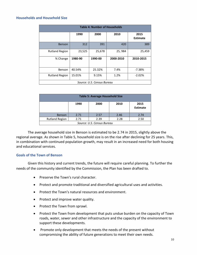


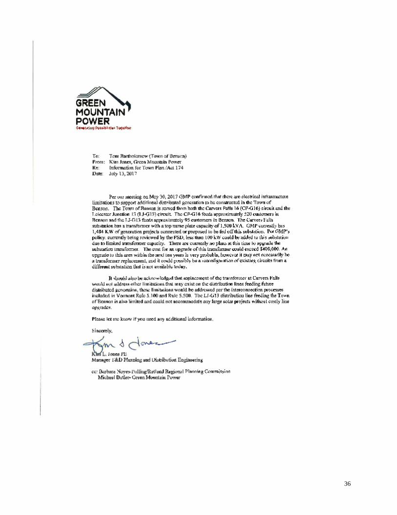


![Benson Lecture Inpla[1] Phil Benson](https://static.documents.pub/doc/80x56/5549e849b4c90518488b4ca4/benson-lecture-inpla1-phil-benson.jpg)


