Conceptualizing an established network of a community based flood early warning system: Case of Cawang, East Jakarta, Jakarta, Indonesia Jonatan A. Lassa (Institute of Resource Governance and Social Change, Kupang) Saut Sagala (School of Architecture, Planning and Policy Development, Institute of Technology Bandung, Bandung, Indonesia; Institute of Resource Governance and Social Change) Adi Suryadini Program Manager Disaster Risk Reduction, World Vision Indonesia, Jakarta January 2013 Working Paper No. 3 www.irgsc.org/publication The views expressed in the IRGSC Working Paper are those of the author(s) and do not necessarily reflect those of the Institute of Resource Governance and Social Change. The Working Papers have not undergone formal academic review and approval. Such papers are included in this series to elicit feedback and to encourage debate on important public policy challenges on development and resources at risks. Copyright belongs to the author(s). Papers may be downloaded for personal use only.
Transcript
Conceptualizing an established network of a community based flood early warning system: Case of Cawang, East Jakarta, Jakarta, Indonesia
Jonatan A. Lassa
(Institute of Resource Governance and Social Change, Kupang)
Saut Sagala
(School of Architecture, Planning and Policy Development, Institute of Technology Bandung, Bandung, Indonesia; Institute of Resource Governance and Social Change)
Adi Suryadini
Program Manager Disaster Risk Reduction, World Vision Indonesia, Jakarta
January 2013
Working Paper No. 3
www.irgsc.org/publication
The views expressed in the IRGSC Working Paper are those of the author(s) and do not necessarily reflect those of the Institute of Resource Governance and Social Change. The Working Papers have not undergone formal academic review and approval. Such papers are included in this series to elicit feedback and to encourage debate on important public policy challenges on development and resources at risks. Copyright belongs to the author(s). Papers may be downloaded for personal use only.
Link: http://www.irgsc.org/pubs/wp.html Using empirically grounded evidence, IRGSC seeks to contribute to international and national debates on resource governance, disaster reduction, risk governance, climate adaptation, health policy, knowledge governance and development studies in general. IRGSC Working Paper series is published electronically by Institute of Resource Governance and Social Change. The views expressed in each working paper are those of the author or authors of the paper. They do not necessarily represent the views of IRGSC or its editorial committee. Citation of this electronic publication should be made in the following format: Author, Year. "Title", IRGSC Working Paper No. Date, http://www.irgsc.org/pubs/wp.html Editorial committee: Ermi ML. Ndoen Gabriel Faimau Dominggus Elcid Li Jonatan A. Lassa Saut S. Sagala Institute of Resource Governance and Social Change RW Monginsidi II, No 2B Kelapa Lima Kupang, 85227, NTT, Indonesia www.irgsc.org
List of IRGSC Working Papers .................................................................................................................. 17
4 IRGSC Working Paper Series - WP 3 [www.irgsc.org]
Conceptualizing an established network of a community based flood early warning system: Case of Cawang, East Jakarta, Jakarta
Jonatan A. Lassa, Saut Sagala and Adi Suryadini
Abstracts
Application of social network analysis to the study of early warning systems is not yet available. This paper conceptualizes the established practice of a real world flood warning system in Cawang, Jakarta. It uses social network analysis in visualizing the transmission of flood warning messages in Cawang, Jakarta. The paper concludes that social network analysis is a powerful and promising tool to understand end-to-end early warning systems.
1 Context of Urban Floods in Jakarta
There are many forms of urban risks in Jakarta. Some risks are associated with natural hazards such as floods and earthquakes. Other risks are – just to mention a few - fire, technological hazards, chemical hazards, water pollution and wastes. Traffic accidents often kill people more than any other hazards. There is also urban conflict, everyday crimes and violence including poverty and so on. This paper highlights floods as the recurrent urban hazards often face by urban dwellers in Cawang (East Jakarta) especially those who are exposed to Ciliwung River.
Anthropogenic causes of urban floods especially in the context of mega-cities like Jakarta have been well known. The most often heard argument is that land use change at both downstream and upper stream have modified the hydrological characteristics (Firman 1994). High sediment transports, poor urban waste management including the people behavior that modifies the river function as garbage storages. The absence of good governance in river management adds weight to the floods problem. Urbanization creates more pressure to Jakarta’s flood problems (Texier 2008, Caljouw et. al. 2005). Lack of preparedness and strategic adaptation to flood risks have caused life loss and economic loss in recent disasters in Jakarta (Sagala et. al. 2013)
Urban poverty pushes marginal people to occupy the river banks at any cost. The poor people have very little option concerning where to live but to occupy marginal spaces where high risk is embedded. The ability of the poor to pay for less flood risk and less polluted settlement is obviously low. It is more beneficial to stay at the river banks.
The people who have been living nearby Ciliwung river since 1970s are still able to tell the stories when the river around Cawang were still clean and fishes can be ‘harvested’ on daily basis. In general, the interviewed people in Cawang (RW 3) remembered all the major flood events during the last 40 years. But the major floods have just occurred during the last 15 years. The first was the 1996 flood events where Jakarta got flooded for 20-30% of its total areas and at least ten people died. The second event took place in January 2002 and 40-50% of Jakarta areas got flooded led to an estimated direct damage at Rp. 5.4 trillion and in direct loses is estimated at Rp. 4.5 trillions [2]. The February 2007 Floods were the highest in recent history in terms of effects as 60% of the Jakarta areas and 400 thousand people affected, 74 died and
5 IRGSC Working Paper Series - WP 3 [www.irgsc.org]
some part of Ciliwung such as Kampung Melayu, the water level reached 11 meters high [1]. In Cawang, where WVI has been operating since 1996, the year of the first big flood event in the last 15 years, the water level reached more than 7-9m high or more, depending where it was measured.
Flood risks are not equally distributed to all people. Informal settlements near the Ciliwung bear the risks more than others. Previous findings show that informal settlements are occupied by the poor people. It is also interesting to know that their coping strategy and adaptation to the flood problems are not related to a low perception of flood risks. They in fact face the other pressing routines ‘emergencies’ such as daily life survival, daily risks and other constraints. [1]
1.1 The Project Setting
World Vision Indonesia (WVI) started its “transformative development” in Cawang, East Jakarta in 1996 exactly in the same year when the first big and destructive floods occurred. WVI therefore have been witnessing the three big floods in Jakarta in 1996, 2002 and 2007. It is not clear how these floods affect the NGO's investment for the poor in Cawang and the rest of flood hotspots in Jakarta. However, viewing from the lenses of disaster risk reduction framework, the NGOs have been contributing to reduce vulnerability of the urban poor through economic vulnerability reduction (a.k.a. economic empowerment), social vulnerability reduction (through education, HIV/AIDS and nutrition) and community development in general. It is widely known today that the most vulnerable groups in disasters are children and women. WVI works to “improve the quality of life of the boys and girls through measureable change in system and structure, behavior change, and economic resilience of households in East and North Jakarta“ [6, p.3].
WVI recently supported disaster preparedness project namely “CAPABLE“ (or capacity building on learning efforts on disaster management). The overall goal of CAPABLE is to improve the response ability of the organization in saving lives, improving quality of response and in protecting development efforts through building sustainable community and WVII disaster management capacity. In Cawang, the CAPABLE conducted some trainings including community based disaster risk management training for 12 Urban Program staff from Cawang. The training was followed by a workshop in October 2008 in Cawang where stakeholders such as Kelurahan Cawang, Puskesmas, Socal Department, Tantip Kramat Jati, Polsek, Pokdar, Satlinmas, RWs (or sub-villages) and KSM (self-help groups) participated. The objective of the workshop is to gain information and identify the needs for a community based flood management.
The workshop produced Standard Operational Procedures (SOP) for flood preparedness in each location especially in RW 01, 02, 03, 05, 08 and 12. The SOPs contain information regarding what to do before, during and after disasters. There is a symbolic event at the end of the training as the SOPs were handed to Head of Cawang Village (Lurah).
After the SOPs for flood preparedness were drafted, the project procured a set of flood early warning system equipments including warning messenger tools such as bicycles equipped with loud speakers.
Basically, there was lack of regular activities after November 2008. Engagement with the local communities has been sustained through community development activities. In 2009, there
6 IRGSC Working Paper Series - WP 3 [www.irgsc.org]
was barely activity concerning the flood preparedness. Each RW was presumed to sustain their own routines such as pre emergency activities and communal work on waste management. The CAPABLE formally ended in 2010. This paper only focuses on progress in RW 01 in Cawang and it is ignorant of the recent progress in the other RWs.
Table 1 WVI disaster preparedness related activities in Cawang 1996-2011
Disaster reduction related activities?
Co
mm
un
ity
dev
elo
pm
ent
(plu
s m
ino
r fl
oo
d r
esp
on
se?
– n
eed
cla
rifi
cati
on
)
Co
mm
un
ity
dev
elo
pm
ent
Co
mm
un
ity
dev
elo
pm
ent
(p
lus
min
or
flo
od
re
spo
nse
? –
nee
d c
lari
fica
tio
n)
Co
mm
un
ity
dev
elo
pm
ent
Co
mm
un
ity
dev
elo
pm
ent
(p
lus
min
or
flo
od
re
spo
nse
? –
nee
d c
lari
fica
tio
n)
CA
PA
BLE
sta
rt in
Caw
ang:
Sta
ff T
rain
ing,
CB
DR
M
Wo
rksh
op
, EW
S p
rocu
rem
ent
CA
PA
BLE
- W
ork
sho
p –
Ch
urc
h a
nd
DR
R i
n E
ast
and
No
rth
Jak
arta
Co
mm
un
ity
dev
elo
pm
ent
Co
mm
un
ity
dev
elo
pm
ent
(p
lus
min
or
flo
od
re
spo
nse
?
(plu
s m
ino
r fl
oo
d r
esp
on
se?
– n
eed
cla
rifi
cati
on
)
Urb
an C
om
mu
nit
y R
esi
lien
ce t
hro
ugh
Dis
aste
r R
isk
Red
uct
ion
(U
CR
DR
R)
(Semester)
Year
1996 1997-2001
2002 2003-2006
2007 2008 2009 2009 2010 2010 2011
Commitment to reduce disaster risks in Cawang has been sustained through the WVI’s policy at higher level. World Vision’s Humanitarian and Emergency Affairs (HEA) committed to build “Disaster Resilient Communities for the Well-being of Children.” It sustains the activities in Cawang through its new planning for “Urban Community Resilient through Disaster Risk Reduction“ to be implemented from 2011 onwards (WVI 2011). Recently, it seeks for community inputs through some participatory research workshops (ADPC 2011) in regards to the real needs concerning risk management.
Table 2 demonstrates the chronology of WVI activities in Cawang based on a broad disaster preparedness concept to link with community development. This is not to evaluate the agency’s work but to provide a comprehensive context for readers to understand the background and settings. Even though the CAPABLE’s inputs 2008-2010 in Cawang is minimum, it is interesting to know whether good outcomes could actually be generated considering the NGO's long term engagement with the local communities and local government in Cawang.
7 IRGSC Working Paper Series - WP 3 [www.irgsc.org]
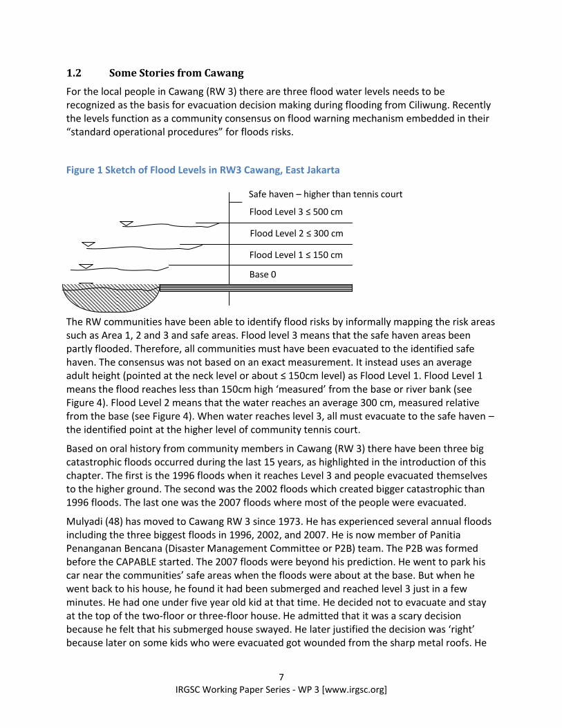
1.2 Some Stories from Cawang
For the local people in Cawang (RW 3) there are three flood water levels needs to be recognized as the basis for evacuation decision making during flooding from Ciliwung. Recently the levels function as a community consensus on flood warning mechanism embedded in their “standard operational procedures” for floods risks.
Figure 1 Sketch of Flood Levels in RW3 Cawang, East Jakarta
The RW communities have been able to identify flood risks by informally mapping the risk areas such as Area 1, 2 and 3 and safe areas. Flood level 3 means that the safe haven areas been partly flooded. Therefore, all communities must have been evacuated to the identified safe haven. The consensus was not based on an exact measurement. It instead uses an average adult height (pointed at the neck level or about ≤ 150cm level) as Flood Level 1. Flood Level 1 means the flood reaches less than 150cm high ‘measured’ from the base or river bank (see Figure 4). Flood Level 2 means that the water reaches an average 300 cm, measured relative from the base (see Figure 4). When water reaches level 3, all must evacuate to the safe haven – the identified point at the higher level of community tennis court.
Based on oral history from community members in Cawang (RW 3) there have been three big catastrophic floods occurred during the last 15 years, as highlighted in the introduction of this chapter. The first is the 1996 floods when it reaches Level 3 and people evacuated themselves to the higher ground. The second was the 2002 floods which created bigger catastrophic than 1996 floods. The last one was the 2007 floods where most of the people were evacuated.
Mulyadi (48) has moved to Cawang RW 3 since 1973. He has experienced several annual floods including the three biggest floods in 1996, 2002, and 2007. He is now member of Panitia Penanganan Bencana (Disaster Management Committee or P2B) team. The P2B was formed before the CAPABLE started. The 2007 floods were beyond his prediction. He went to park his car near the communities’ safe areas when the floods were about at the base. But when he went back to his house, he found it had been submerged and reached level 3 just in a few minutes. He had one under five year old kid at that time. He decided not to evacuate and stay at the top of the two-floor or three-floor house. He admitted that it was a scary decision because he felt that his submerged house swayed. He later justified the decision was ‘right’ because later on some kids who were evacuated got wounded from the sharp metal roofs. He
Flood Level 3 ≤ 500 cm
Safe haven – higher than tennis court
Flood Level 2 ≤ 300 cm
Flood Level 1 ≤ 150 cm
Base 0
8 IRGSC Working Paper Series - WP 3 [www.irgsc.org]
felt that so far, there is misunderstanding of the true story of the 2007 flood. He lives very close to the Ciliwung (about less than 10 meters horizontally to Ciliwung). All of his important letters, certificate were lost in the flood events.
1.3 Research objectives and questions
The paper asks tries to understand the real world network of flood early warning systems. Using the evidence from Cawang, the author visualize a simple flood warning networks in Jakarta. We also willing to contribute to the academic literature concerning the innovation in early warning systems research. This investigation combines both literature review and field interviews in Cawang during 15-26 July 2011. Some of the new information was validated by acquiring participants from Cawang in an ECB workshop in Jakarta on 26 July 2011.
2 Local Government’s Views on the Floods Problems
Disaster contingency budget for Cawang Village for fiscal year 2011 was is Rp. 41 million (Djaelani 2011). The total population of Cawang is about 50,000. There are 12 RWs and 121 RTs. The disaster account can only be used activated and used once disasters occur.
The village’s contingency plan was not a written plan but it simply existed in the Kelurahan Cawang‘s annual budget. So far, the power for decision making lies in the hand of Lurah (head of village). The Lurah decides whether “this or that flood event is a disaster or not” – explained by the Lurah’s deputy. Therefore there is an indication of practice on village disaster declaration.
No capacity development for disaster preparedness at RW levels made by Kelurahan till 2011. During the 2007 floods, village governments had received warning one week in advance. In technical language, there is a luxury of ‘lead time’ warning – early warning message had been transmitted 7x24 hours in advance. The deputy of village head argued that “the people simply made no evacuation even when their houses submerged in the flood waters”. This means that their evacuation orders were not too effective. One of the acceptable knowledge in EWS studies is that effective response to warning from the local communities depends on several variables. Amid the absence of system for effective early warning, an effective early response is probably just a wishful thinking. There should also be another element such as trust to the system. Trust is an important variable but it does not freely fall from heaven. It requires a great deal of time investment, drilling rehearsal, community preparedness and so on. These things are either missing (obviously) or did not exist.
Here is some identified capacity for flood response that helps Kelurahan Cawang:
PMI’s SIBAT Emergency kitchen tools is stored in the village office
PMI’s SIBAT ropes and tents are available for emergency.
PMI’s SIBAT share their assets for flood evacuation with the Kelurahan
9 IRGSC Working Paper Series - WP 3 [www.irgsc.org]
The Kelurahan office is connected to the warning dissemination from both Balai PSDAW Ciliwung-Cisadane and Emergency Desk at Walikota Jakarta Timur (see Figure 6, the Flood warning chain).
For the “distance flood“ or Banjir Kiriman – the Kelurahan relays on these warning channels.
The Kelurahan has 10 Pamong Praja police that posses embedded mandate as first responder to floods. So far the Kelurahan also coordinates with SAR during emergency
NGOs are also helpful during emergency. World Vision is one of the examples – some billboard from WVI concerning flood risks is displayed in the Kelurahan office.
So far waste management is seen as a very difficult problem to tackle. But some mechanism has been made so far done such as co-management between RT/RT level, Kelurahan and Cleaning Unit of the East Jakarta Municipality.
Business communities in Cawang often support local governments and communities when the scale of the events becomes catastrophic. In January 2013 floods, several business firms including state own companies (BUMN) have been supporting emergency responses to the people in Cawang.1
3 “Living with Floods” as Community Adaptation to Floods in Cawang
Communities have options to deal with the floods. In Cawang, there have been emerging forms of urban adaptation to floods as demonstrated by RW 3 community in Cawang. The first is voluntary exposure (or sometimes known as living with floods (LWF) approach) option. LWF approach means that the communities decide to live in the same risky place but they manage to find some ways to adapt and cope with the risks. This includes some level of risk acceptance such as acceptable flood loss. Flood adaptation requires learning in a longer time span. Given the fact that all the interviewees have lived either longer than 35 years or since they were born, certain adaptation mechanism emerged and sustained.
One form of “voluntary exposure” to flood risks is the decision to increase the level of the houses from a non-staged to staged houses. Based on long term observations from 1996, 2002, and 2007 floods, some house owners have elevated their houses from one to two or three levels. The people have decided to evacuate vertically in times of flood emergency. This option has been complemented by some other measures: the ground floors are designed to be flooded. Therefore, the asset put in such a place including furniture are often less valuable assets. Detail quantitative calculations of the assets put in the base floors has been done recently and it is likely that the value of assets is below Rp. 1 millions (Mone 2008) as recently witnessed in Cawang RW 3.
If vertical evacuation failed – as in the case of 2007 floods, horizontal evacuation must be the alternative option available for the people. Horizontal evacuation means that the people
11
See food distribution by BUMN: http://www.bumn.go.id/waskita/publikasi/berita/pt-waskita-karya-bantu-korban-banjir-di-cawang-dan-senen/ [last accessed 24 Jan 2013].
10 IRGSC Working Paper Series - WP 3 [www.irgsc.org]
organized themselves to move to higher ground at identified safe haven i.e. higher ground near the community tennis court in RW3. This horizontal evacuation is actually ‘diagonal evacuation’ due to the nature of riverbank near the Ciliwung River is sometimes found to be sloped areas.
The other option is permanent migration out of the river bank of Ciliwung. There were three households in RW 3 whose houses were collapsed during 2007 flood decided to leave the village. One of the reasons is because they have access to better housing provided by their employer or by other means.
But in order to be fully adaptive to floods, the community needs certain comprehensive mechanism which will be introduced later sections. One of the options is community flood warning systems includes several components. In-situ flood monitoring means the community pay attention to different kind of flood levels.
4 School Adaptation to Floods
Schools have been adapting to floods. SD Madrasah Nurul Iman is one of the schools. The school was built in 1982. Mr. Umar, the current head of school, joined the as a teacher in early 1990s. He has been through the 1996, 2002 and 2007 flood events. After the 2002 floods, the Madrasah made the decision to have a second floor. The decision was ‘right’ because they can evacuate their important documents including students’ certificates that must be kept for 25 years in their archive. But the 2007 floods went higher than their prediction. All the certificates were submerged in the muddy water. Their library was affected. Only a few documents were saved. After 2007 floods, they decided to build a new section with higher elevation. They predict that if the 2007 flood comes again, their present flood adaptation measures can save all the important documents. So the floor level is now higher than 2002 construction. They also put all the documents and certificates at much higher level than the flood level of 2007, wishing all the things they do will pay off in the future floods.
During the floods in February 2012, the Nurul Iman School were also affected by floods. The good news is that only their ground floor were inundated. The pupils were sent home for a few days because the height of the inundation has reached more than 50cm (More 2012).
Therefore informal vertical evacuation is also one of the strategies for the school to deal with floods. In the first floor (or base) the school no longer use for school rooms. The base is now used as multipurpose rooms such as praying room, students and parents occasional gatherings, and some formal events. All the school rooms have been moved upstairs. The first floor (base) is now used for multiple purposes including as a prayer room for the students and meeting room for diverse purposes. Apart from vertical evacuation the school has also identified their own horizontal evacuation scenarios.
The problem is that the reactive approach to elevate houses and schools as new flood records emerged, will lower quality of the buildings which in the future can be very vulnerable to earthquakes tremors. The connection between reactive adaptation to floods through community vertical evacuation needs serious intervention from the local government. Options
11 IRGSC Working Paper Series - WP 3 [www.irgsc.org]
can be in form of building retrofit that can anticipate long term flood adaptation and earthquake mitigation.
5 Flood Warning Practice in Cawang
Since most of the Cawang people decided to stay on the river bank, the LWF approach needs a comprehensive plan. If all their adaptation measures above finally failed in certain extreme flood events, there is one option left such as to evacuate themselves from their staged houses to higher ground and safer places. This needs a good practice of flood early warning systems in place. The CAPABLE project has made some investment to improve the existing system. Table 3 provides an example of community based early warning components in Cawang with its existing component and some added components. Most of the added components have been facilitated by the project. In fact, conceptually, there is no clear framework explaining the system. However, we conceptualize the practice of community flood early warning system (CBFEWS) based on the famous ISDR’s people center EWS.
From the upper stream of warning system, the Balai Pusat Sumberdaya Air Wilayah (PSDAW) monitors the Katulampa gate water. PSDAW later transmit the typical SMS warning messenger from Ciliwung-Cisadane and it is often CC to the Cawang communities' disaster preparedness team (or P2B RW3).
“Katulampa 100-70 cm, mendung. Depok 95cm mendung, hujan. Manggarai 680cm hujan. Antisipasi untk wilayah yang dilalui kali Ciliwung dan kali Baru-nya sudah di 87kan untuk walikota, camat, lurah dan RW/RW, tokoh2. (English: Katulampa 100-70cm, cloudy. Depok is 95cm, cloudy and rain. Manggarai 680cm, rain. Anticipation for the areas passed by Ciliwung and Baru rivers have been disseminated to Major, head of subdistricts, head of villages and RWs/RTs.)
The SMS warning information is transferred to the flood information board at in village (or Kelurahan) and sub-kelurahan (RWs). In RW3, two water levels information from the PSDAW Ciliwung-Cisadane is needed as shown in Figure 5.
Figure 2 Flood Information Transfered From SMS to Community Information Board
12 IRGSC Working Paper Series - WP 3 [www.irgsc.org]
Figure 3 Flood early warning chain in Cawang, RW 3
Actual nodes hypothetical nodes
Upstream EWS (water gates)
Local government hierarchy
Community disaster response structure
Procured components
Media
External supports
Households/ communities
There is apparently an emerging CBFEWS as seen in the established warning network above. Figure 6 noted that PSDAWS Ciliwiung-Cisadane received information on water levels in Katulampa (Bogor) and Depok and then transmitted to the downstream areas such as Cawang, East Jakarta governments (from RWs to Kelurahan and Major). Information from Figure 5 and the SMS are later interpreted by P2B (the sub-village disaster responders). This interpretation becomes the basis for closer monitoring at their local water level monitoring. First responders have been an integral part of the system as they come from the external to help the local communities. They are Tagana (volunteers managed by Social Department) and Disaster Preparedness Team of Indonesian Red Cross (Sibat PMI) and the NGOs/volunteers.
The nodes’ size in Figure 6 reflects the importance (based on the number of links each node possess) of the warning node to the local communities. TVs, FM radios and RAPi also receive information and spread to the public at large. TVs and radios are therefore hypothetically a central nodes in the system. The lead time for 2007 floods was 7 days in advance and TV have played significant roles in transmitting the messages. But these nodes sometimes cannot be used as electricity often shutdown in times of emergency at the flood hotspots.
13 IRGSC Working Paper Series - WP 3 [www.irgsc.org]
Figure 6 noted new emerging warning transmission nodes in RW3 in Cawang. The point is not only that the new nodes for warning transmission are important but they adds new dimension to the warning system as they are 'community based'. This study is incomplete as time is short and no claim regarding the ownership and warning effectiveness. But there is apparently good direction in RW 3 in Cawang which subject to significant improvement. Further study should also be made whether communities have clear ideas on which warning transmission channels provide them a great deal of effective response to warnings such as from sirens and HT radio? How this is played out during the 2012 and 2013 floods, it requires investigation.
Table 2 Community based early warning components in Cawang
Community based flood warning components Pre-existing components
Added components
Remarks
Risk Knowledge and governance
Participatory risk assessment, vulnerability and capacity analysis
- X Capacity building via staff training in 2008 and via community meetings
SOP on flood warning in six RWs - X
Capacity building - X
Establishing Village Response Team X (RW 1) X
Socialization of flood level 1, 2 and 3 X
People evacuation plan Partially X
Monitoring hazards and vulnerability
Kelurahan-RW Monitoring and connection X
Water level monitoring at the Ciliwung River by P2B X
PMI-SIBAT’s monitoring system X
Warning transmission and communication
Warning sirens X
HT X X
SMS X X
mobile phones X
door to door warning - bicycles equipped with speakers
X X
Flood information board X
Radio X
TVs X
Adaptive response to floods
Vertical evacuation raising the houses’ level X
Evacuate valuable assets and documents X
Informal evacuation – ‘mice holes model’ X
People evacuation plan Partially X
School flood drilling X
14 IRGSC Working Paper Series - WP 3 [www.irgsc.org]
Warning chains mapping alone does not tell the effectiveness of the system. Table 3 provides detailed information regarding risk knowledge setting and self governance of the warning system at RW3 level. Self-governance means that the community is able to self-sustain the system with limited external inputs. There is local structure such as the P2B (disaster management committee) at RW level. There has been also regeneration of the committee members recently. There are apparently good cooperative members. There is also a standard operational procedure concerning what to do during the flood events. Members of P2B have also been trained and the trained members also conduct risk communication concerning floods and response measures to floods.
P2B have also made a successful communication with the PSDAW Ciliwung-Cisadena and they have been able to mobilize their own and external resources to response to recent floods. So far, flood monitoring is regularly done and the information is communicated to the communities. The monitoring is however done by field levels (at different points) only and still lack on the vulnerability monitoring (such as how many households have their own vertical evacuation, and how many not yet have access to such a system, and how many households are in category of ‘the must evacuate horizontally’ families etc.)
Warning transmission can be seen in both Figure 6 and Table 3. So far, due to its urban context, Cawang has been blessed with multiple warning chains.
The response component is important. Early warning is useless without early response. But the early response needs to start early on far before the catastrophic floods coming. The lessons from 1996, 2002 and 2007 have been learnt by RW3 communities. The P2B have also facilitated evacuation routes from all points in RW3 to the safe haven.
6 Conclusion
Household level adaptation can be counted as preparedness and EWS elements. Both formal and informal evacuation system needs to be reckoned as innovation by the stakeholders. There is an informal evacuation plan such as “lubang tikus“ (or rat hole) evacuation model made at higher elevation in some RWs (Anakotta 2011). This informal social arrangement to flood evacuation is worth of further study.
What is going on in RW3 is that there is now evacuation planning embedded in the SOP of flood warning as agreed by P2B. The progress is in good direction. However, improvement is necessary. One of the ‘weakness’ is that from the outset, the community is simply calling the system as disaster preparedness committee. In fact, what is going on is far richer than what is generally perceived.
At the moment, flood drilling in the schools is probably the least sustainable FEWS component as it is not clear who should hold the responsibility. Flood adaptation and preparedness at school needs to be strengthen. P2B RW3 and school preparedness at Madrasah Nurul Iman provide a set of good example how the smallest unit of communities (including school) can demonstrate a good example of disaster preparedness at school level.
15 IRGSC Working Paper Series - WP 3 [www.irgsc.org]
There is an emerging practice of community based flood early warning system. Each EWS component needs to be monitored, evaluated and improved. But what is also crucial is that the achievement in RW3 can be conceptualized as a body of practical knowledge which can be shared and up-scaled to the other RWs and Kelurahan in flood prone areas along the Ciliwung River and other river channels. RW3 provide examples on how a strong and solid community based organization such as P2B can sustain preparedness in their locality.
The use of social network analysis in this paper is limited to a simple visualization of flood EWS network. In the technical terms of social network analysis, warning systems comprise of links and nodes. Nodes represent the source of warning and targeted subjects where warning should be sent/transmitted. The nodes can be any relevant organizations and individuals that work to fulfill the mandates of the warning systems. We argue that early warning systems is about connecting the nodes and connecting unconnected nodes. Figure 6 exemplifies the fact that should some of the critical nodes become dysfunctional (or collapsed), it will eventually decrease the effectiveness of an early warning systems. Therefore, governing a warning systems simply mean governing the nodes to be connected.
Acknowledgement
All the mistakes and misinterpretation contain in this paper belong to the authors. Early form of this paper was part of Chapter 2, good practice collection is commissioned by ECB Indonesia (via WVI) to Circle Indonesia. The current version cannot be accomplished without helpful hands from Adi Suryadini (WVI Jakarta), Alfred Anakotta (WVI Urban Jakarta) and Asep Djaelani (Wakil Lurah Cawang), Dewi Anggraini (ADPC), Mulyadi, Wiwin, Gerry, Ivo, Yasmanlinus (P2B RW 3 Cawang) and Umar (Madrasah Nurul Iman) and Wahyu Widayanto (ECB). The authors have received valuable inputs from many ECB Indonesia members who participated in the first workshop (26 July 2011) and second workshop (23 August 2011). Thanks to Maharani Hardjoko (Save the Children), FX Hanung S, Vanji Dwi Prasetyo, Adi Suryadini, Alfred Anakota, Ivan Tagor, Jimmy Nadapdap (WVI), Yasmanlinus (P2B Cawang), Wahyu Widayanto (ECB Indonesia), Helmi Hamid and Josephine Pipin (CRS), Eva Eka P, Farah R Rachmat (Mediciens Du Monde), Ade Darmawansyah (CARE), Viktor Rembeth (UNJSP-DRR), Mia Marina, Ade Reno (OXFAM), Dini Isnaeni, Dewi Hanifah and Intan M.A (Mercy Corps), Dwi Yuliyanti (IMC), Faisal Djalal (MPBI), Rini and Suryadi.
Reference
ADPC 2011. Research on Urban Disaster Risk Reduction in two Sub-districts, Kramat Jati and Cilincing, Jakarta. Urban Community Resilience through Disaster Risk Reduction (UCRDRR) of World Vision Indonesia Revised Version July 2011.
Anakotta, A., (2011) WVI Urban Jakarta Timur. Personal Interview 18-19 July 2011
Caljouw, M., Peter J.M. Nas and Pratiwo (2005). Flooding in Jakarta: Towards a blue city with improved water management. Bijdragen tot de Taal-, Land- en Volkenkunde (BKI) 161-4 pp. 454-484.
16 IRGSC Working Paper Series - WP 3 [www.irgsc.org]
Davis, C. (2010). Evaluation of Indonesia CAPABLE: Disaster Preparedness Project. World Vision Indonesia. Unpublished Draft May 13, 2010. World Vision Indonesia HEA Project ID 185869.
Djaelani, A. (2011). Personal Interview Vice Lurah of Cawang. Personal Interview on 19 July 2011.
Firman, T. (1994). New Town Development in Jakarta Metropolitan Region (JMR). Habitat International. Vol. IX. No. 3. pp. 79-94.
Mone, I.C.M. (2008). Vulnerability assessment and coping mechanism related to floods in urban areas: A community-based case study in Kampung Melayu, Indonesia UGM-ITC MSc Thesis
More, I. (2012). Banjir di Cawang, Sekolah Nurul Iman Diliburkan. Kompas, Senin, 13 Februari 2012.
Sagala, S., Lassa, JA., Yasaditama, H., and Hudalah, D. (2013) The evolution of risk and vulnerability in Greater Jakarta: contesting government policy in dealing with a megacity’s exposure to flooding. IRGSC Working Paper 2, January 2013.
Texier, P. (2008). Floods in Jakarta: when the extreme reveals daily structural constraints and mismanagement. Disaster Prevention and Management. Vol. 17 No. 3, pp. 358-372.
World Vision Indonesia, Project Proposal FY11, Urban Community Resilient through Disaster Risk Reduction, 2010