Thün, Geoffrey Thün is Associate Professor of Architecture at the University of Michigan, an adjunct professor at the University of Waterloo, and a partner at RVTR. He received a 2008 Young Architects Forum Award, and his firm has been awarded the 2009 Canadian Prix de Rome in Architecture. Velikov Kathy Velikov is Assistant Professor of Architecture at the University of Michigan, an adjunct professor at the University of Waterloo, and a partner at RVTR. She received a 2008 Young Architects Forum Award, and her firm has been awarded the 2009 Canadian Prix de Rome in Architecture. Conduit Urbanism Regional Ecologies of Energy and Mobility 83
Transcript
Thün,Geoffrey Thün is Associate Professor of Architecture at the University of Michigan, an adjunct professor at the University of Waterloo, and a partner at RVTR. He received a 2008 Young Architects Forum Award, and his !rm has been awarded the 2009 Canadian Prix de Rome in Architecture.
VelikovKathy Velikov is Assistant Professor of Architecture at the University of Michigan, an adjunct professor at the University of Waterloo, and a partner at RVTR. She received a 2008 Young Architects Forum Award, and her !rm has been awarded the 2009 Canadian Prix de Rome in Architecture.
It is frequently predicted that the depletion of carbon-based fuels will precipitate a decline in automobility, a collapse of global trade networks, and even a return to small-scale city patterns. Other than a tacit belief that the near future might look something like the near past, there is little evidence to support this vision. Current patterns indicate, however, that across North America an entirely different urban order is emerging, driven by a complex of forces whose spatial and operative logistics anticipate a peri-urban condition unlike the structures witnessed to date. Parallel to the current crisis of carbon-based fuel supply, planners, politi-cians, engineers, and industrial leaders foresee a future of increasing demands for mobility combined with an unprecedented intensity of urbanization and a decaying transport infrastructure. Interconnected large-scale regional urbanities as well as contempo-rary energy concerns present thus an organizational / infrastructural challenge. In this context, existing infrastructures constitute a spatial matrix that, when combined with intensi!ed systems of mobility and the strategic harnessing of energy potentials, serves to anticipate the emergence of a synthetically net-worked hybrid infrastructure to support and propa-gate emerging urbanisms.
Network
The highway was arguably the single most instrumental factor in structuring settlement patterns and economic development in North America during the second half of the twentieth century. An astonishingly ef!cient and strategically engineered system comprised simply of permutations of near horizontal asphalt surfaces, it is con!gured to optimize the logics and logistics of transit and transport throughout the continent. Although separate interstate highways had been constructed as early as the Lincoln Highway in 1913, it was Eisenhower’s Federal Aid Highway Act of 1956 that promoted the interstate highways as an integrated and complete network. The Act not only provided funding for highway construction but also gave each state twenty years to build out the network, so that mobility could operate continuously throughout the nation. More than !fty years later, rapidly evolving urbanization and energy needs demand a similarly totalized approach that prioritizes a synthetic networking of mobility, energy, and economy. Where the latter half of the twentieth century witnessed the establishment of a !ne-grained mobility network and the production of low-density urbanism, the twenty-!rst century will be de!ned by the consolidation of supersized, multicentered, networked urbanities, as the interconnection and densi!cation of proximate urban centers create the emerging megaregions
of North America. This urban formation, !rst identi!ed by French geographer Jean Gottman’s 1961 Megalopolis, has become the focus of several prominent land use and planning agencies.1 Megaregions can be de!ned as agglomerated networks of metropolitan areas with integrated labor markets, infrastructure, and land-use systems that share and organize complex and interdependent transportation networks, economies, ecologies, and cultures.
The geography of megaregions inevitably coincides with areas of maximal stress and congestion, due to population concentration and increased mobility and freight movement, within current infrastruc-tures, threatening imminent systemic failure. This geographic situation coincides with the demise of cheap and plentiful carbon-based fuels and a pro-jected energy transformation from single-sourced fuel to a variety of sources, including solar, wind, nuclear, carbon, geothermal, hydrological, and biomass. An ambitious and robust regional vision that reconceives an entire network is necessary. Such a vision would opportunistically combine the agendas of regional mobility and renewable ener-gies with potential new urbanities centered around the highway infrastructure, and connect existing urban centers and other modes of transport such as air, water, and rail with critical resource supply and strategically differentiated economic clusters, reinforcing and supporting the diverse spatial logis-tics of megaregional agglomeration economies, as identi!ed by Saskia Sassen.2 Through such a lens, the megaregion becomes a primary sociopolitical unit, overshadowing the agency of individual state, provincial, and even national boundaries and struc-tures, and its polycentric form becomes a powerful enabler for diverse populations and economies.
Fields
The largest and most populous of the emerging North American megaregions is the Great Lakes Megaregion (GLM), including Chicago, Detroit, Toledo, Toronto, Buffalo, Pittsburgh, and Cincinnati and in some cases extending to the Atlantic port of Montreal and the Midwestern cities of Milwaukee, Columbus, Indianapolis, and St. Louis.3 However, its geographic, ecological, and resource-related territory should tactically expand this boundary to include the watershed of the !ve Great Lakes. As a regional territory, it controls one-!fth of the world’s supply of fresh water and 10,900 miles of shoreline, constitutes the world’s largest concentration of re-search universities, and is home to percent of North America’s and 11 percent of the world’s Forbes’ 2000 international company headquarters.4 Daily, more than $900 million worth of goods, or 25 percent
of bilateral trade, crosses the Ontario-U.S. border via the highway system within the GLM. Southern Ontario’s Highway 401 holds the dubious honor of being North America’s busiest highway. The sec-tion of 401 that cuts through Toronto has been expanded to eighteen lanes and typically carries 420,000 commuter and commercial vehicles a day.5 Traf!c congestion on Highway 401, already severe, will be aggravated by projected population growth in Canada and the U.S. being planned adjacent to existing major highway arteries within the GLM.6
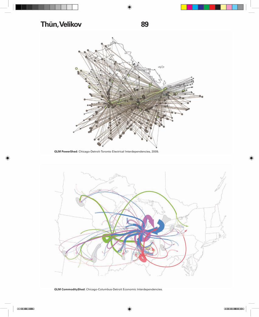
Energy distribution networks in the GLM are in-extricably linked and limited by the footprint and logics of existing highway infrastructures. Fuel pipelines, re!neries, and service depots combine optimized transmission vectors with the cumber-some constraint of road-based distribution. Power corridors follow lines of expedience from resource origin to the highway’s population centers. Though robust, this matrix of energy delivery is inadequate to service the megaregion’s projected growth, as witnessed by “out of fuel” signage and system-wide grid shutdowns. Within this context of terminal con-gestion, an astonishing web of regional interdepen-dence exists. Visualization of the resulting Commut-erShed, CommodityShed, and PowerShed ecologies further reinforces the necessity of conceiving of a synthetic, regionally scaled interdependent infra-structure of resource development, distribution, and projection.
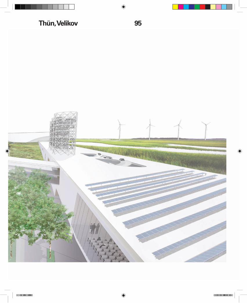
The Great Lakes Megaregion has signi!cant amounts of renewable energy resources, with ap-proximately 7.2 gigawatts (GW) of hydroelectric energy, a vast potential for biomass energy produc-tion, and 1.5 to 2 kW/hrs/m2 of solar energy poten-tial daily.7 However, the region’s greatest potential PowerShed contribution lies in 320 GW of power that could be generated annually from Great Lakes offshore wind farms. If fully exploited, these sources could provide 25 percent of the power needs of the United States8 and constitute a signi!cant interre-gional export base. This increased capacity demands a new network of high-voltage transmission lines. To realize the potential strategic advantage of this suite of opportunities, a retooling of infrastructure, an ad-aptation of new technologies, and the development of overarching political visions and cooperation are required. Geographically and logistically, the high-way system network, replete with strategic conduit channels, might hold the key to the next generation of regional infrastructures.
Conduits
Transport experts argue that the most ef!cient tech-nology for a mobility revolution resides in electri!ed high-speed rail tied to renewable energies. Maxi-mum speed is coupled with minimal electrical con-version and distribution losses, as vehicles receive a steady supply of electricity from the grid.9 Electri-!ed high-speed rail necessitates the construction of new elevated rail lines to achieve as horizontal a surface as possible for travel speeds of more than 300 kilometers per hour. This type of system has the capacity to link the GLM’s urban centers from Chicago to Toronto in less than three hours, radi-cally altering effective intraregional time and space. High-speed passenger rail could also help allevi-ate congested highway surfaces and rail for freight (projected to double in the next twenty-!ve years) and could signi!cantly decrease the use of short-haul "ights, which encumber airports and consume disproportionate amounts of fuel.
At the con"uence of the networks of people, goods, and energy, a signi!cant opportunity emerges to consider the rapid urbanization occurring proxi-mate to existing highways, the need for increased capacity along existing highways, the ef!ciency of electri!ed high-speed rail, and the need for new high-capacity energy transmission lines to distrib-ute the electricity produced by renewable energy resources. The highway cross-section becomes a conduit of a bundle of networks of infrastructure, including high-speed rail and Mag-Lev electri!ed rail, dedicated vehicle lanes, high-voltage power transmission, and freshwater supply. These vectors are layered to maximize speed, safety, and accessi-bility thus increasing conduit bandwidth, in addition to forming a resource umbilicus that can service increasing densi!cation and demand along the line. Dimensioned to operate within the existing right-of-way of major highways, this system facilitates ease of implementation by eliminating land acquisition and expropriation, and recognizes the geography of the highway as the driver for urban growth.
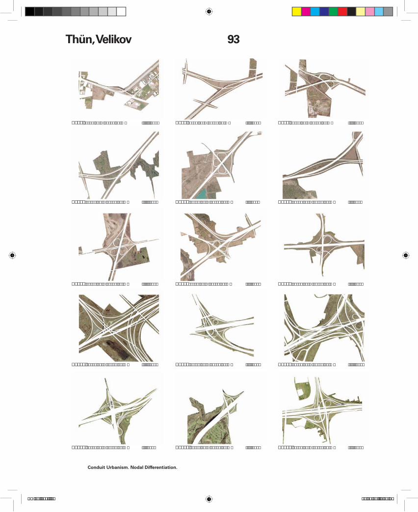
The introduction of these conduit structures has broader implications for the lands proximate to the line. At a macro level, lands located along existing corridors, and those bounded between the corridor and adjacent infrastructural systems (such as rail), enjoy a strategic advantage. Points of systemic crossing and crossover, understood through the ubiquitous landscape of the highway interchange, become charged with potential by virtue of their inherent availability for development and through the value they possess as points of transfer. As a network, the system privileges the node.
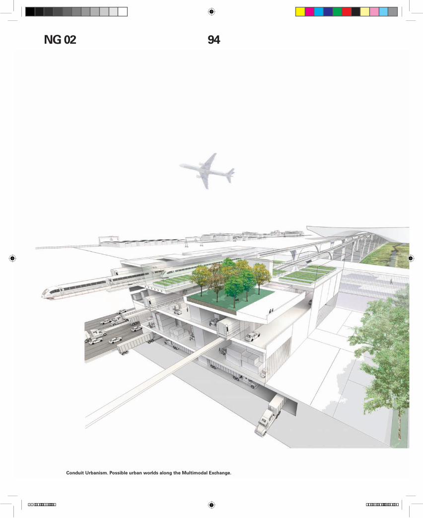
As the system intensi!es, the new typology of the multimodal transfer interchange will become the key nodal type and a dominant megaregional con-struct. These interchanges will be places where the system, its travelers, and resource "ows will meet. The sites and footprints for such developments are already determined by the system. At the moment, each of the over 400 off-ramp interchanges along the I80-I75-401 conduit simply serves for changes in speed and direction. However, the architecture of each interchange renders an average of 44.3 acres (18 hectares) of orphaned adjacent surface lands. These provide an ideal location for modal switch sites and terminal and interchange structures, as well as the potential to house new typologies that will bene!t from the proximity to the mobility and renewable energy conduit. The traditional highway service center with its minimal amenities—fuel station, fast-food joint, strip motel—is no longer suf-!cient. In the post-carbon era of new fuels, a variety of refueling systems will be needed at every service point, each fully integrated with the differentiated modes of travel.
At the intersection of current urban centers, where the high-speed can intersect with local arterials and LRT loops, transport terminals will house parking facilities for commuters and provide secondary tran-sit connections. Rail passes will be integrated with electric mini-car rental facilities for last-mile travel between the terminal and !nal destination. Gate-way sites such as those proximate to regional and international airports will be integrated with access to urban transit networks, while specialized nodes will manage the logistics of border-crossing. Sorting and redistribution sites will include classi!cation yards and consolidation terminals for freight "ows, as well as sites for intermodal interface with rail networks. Considering the sur!cial requirements for warehousing and intermodal redistribution, horizon-tal !elds of logistics zones could develop alongside the interchanges and may span spaces between the new highway and high-speed rail system and exist-ing rail lines. Strategic institutional sites along the conduit can be created to capitalize on the research and development base of the Great Lakes Megare-gion. This conduit urbanism will catalyze intensi!ca-tion and new infrastructural architecture typologies through the upgrade of highway corridors com-bined with emerging systems of renewable energy distribution, mass transit, and freight intelligence. Mobility and power will activate dormant peri-urban landscapes. These territories, ranging from vast !eld conditions to precisely de!ned nodal points, will emerge as key points of friction and opportunity that will condition and de!ne both the Great Lakes
Megaregion and the spaces of the Post-Carbon Highway.
Project Credits: RVTR, Colin Ripley, Maya Przybylski, Mike Vortruba, Erin Shnier, Adam Clark, Matt Peddie, Matt Storus, Pooya Baktash, Jeff Cheng, Carrie Hunter, Eric Malbeuf, Sonja Storey-Fleming.
This work expands on “The Post-Carbon Highway,” commissioned for FUEL, edited by John Knechtel (Alphabet City/ Cambridge, MA: MIT Press, 2008). The authors would like to thank the Canadian Social Sciences and Humanities Research Council (SSHRC) for funding (2009-2013) and acknowledge the dialogue with Charles Waldheim, the 2007 CONVOY Studio at University of Waterloo, and visiting critics: Keller Easterling, Pierre Bélanger, Jason Young, Rob-ert Adams, David Lieberman, Adrian Blackwell, and Mason White.
1 For the early history, see Jean Gottman, Megalopolis: The Urbanized Northeastern Seaboard of the United States (Cambridge, MA: MIT Press, 1961), Constantinos Apostolos Doxiadis, “A Great Lakes Megalopolis?,” Ekistics, 24(145), 1967: 435 - 439, as well as the regional planning visions of Lewis Mumford, Clarence Stein, and Benton MacKaye. 2 Saskia Sassen “Megaregions: Bene!ts beyond Sharing Trains and Parking Lots,” in The Economic Geography of Megare-gions, edited by Keith S. Gold!eld (Policy Research Institute for the Region, Princeton University, 2007), 67.3 There is no consensus as to the de!nition of the bound-ary of the GLM, as identi!cation parameters and methods vary, and economic data is inconsistent between Canada and the United States. See, for example, Epstein Delgado et al. “Methods for Plan-ning the Great Lakes MegaRegion” (2006).4 These statistics have been compiled from a range of sources including “Canadian Census Data” (2006), courtesy StatsCan; U.S. Department of Transportation, Research and Innova-tive Technology Administration, Bureau of Transportation Statistics, “Trans-border Freight” (October 2008); Bureau of Economic Analy-sis, U.S. Department of Commerce, “Regional Economic Accounts” (Sept 2008), Affolter Austin and Milway Caine Milway, “The Great Lakes, A World Leading Bi-national Economic Region” (March 2007), as published by the Brookings Institute and the CIA World Fact Book. https://www.cia.gov/library/publications/the-worldfact-book/ (retrieved February 20, 2009).5 See Ontario Ministry of Transportation, “Goods Move-ment in Ontario: Trends and Issues,” (December 2004), for data regarding Canadian transport statistics.6 Ontario Ministry of Infrastructure Renewal, “Places to Grow: Growth Plan for the Greater Golden Horseshoe” (2006): 7. The American Association of State Highway and Transportation Of!cials (AASHTO) 2007 Report states that “truck volumes are expected to double by 2035, and rail freight to increase by over 60 percent” “A New Vision for the 21st Century,” 2007:57 (www.transportation.org; retrieved March 17, 2008).7 Calculations extrapolated from data sourced via the “Wind Energy Resource Atlas of the United States” National Renewable Energy Laboratory / U.S. Department of Energy (1986), existing data from OPG Data (2009). U.S. biomass potential data can be acquired through the National Renewable Energy Labora-tory / U.S. Department of Energy site http://www.nrel.gov/gis/maps.html. Solar potential data for the U.S.: http://www.nrel.gov/gis/maps.html; Solar potential data for Canada from Natural Resources Canada: https://glfc.cfsnet.n!s.org/mapserver/pv/index.php.8 For offshore wind potential of the Great Lakes, see the following studies: Land Policy Institute, Michigan’s Offshore Wind Potential (September 2008); Helimax Energy Inc., Analysis of Future Offshore Wind Farm Development in Ontario (April 2008), and U.S. Department of Energy, 20% Wind Energy by 2030 (July 2008). 9 Richard Gilbert and Anthony Pearl, Transport Revolutions. Moving People and Freight without Oil (London: Earthscan, 2008), 311.