331


CON'I'EN'l'S
VOLUME I
Wild West Report Summaries ............. . .
An Overview of Reptiles and Amphibians in Alberta's Grassland and Parkland
;ey SECTION
A
Natural Regions ..................... Cottonwood Cns 1 ts. B
Swift Fox Reintroduction Project -Progress Report 1987 ................ s. Herrero et al. c
Pilot Rare Plant Monitoring Program in the Oldman Regional Plan Area of Southwestern Alberta . .. .......... ... C. Wallis et al. D
Piping Plover Studies - Alberta 1987 ..... C.R. Wershler E
A Stratified Random Survey For Burrowing Owls on the Weyburn (62E) and Reg ina (72I) Map Areas .......... D.G. Hjertaas F
The Tall-Grass Prairie Community In Manitoba ............................ S.M. Anderson G
Management of Burrowing Owls in Manitoba: Population Distribution and Plan for Recovery ...... ..... .. .. ....... .. K. A. Thomson H
Monitoring of the Plains Spa d e foot in Southwest Manitoba - 1987 and 1988 . . . W.B. Preston I
Distribution and Status of Piping Plovers in Manitoba - 1986 .......... s. Haig J
Distribution and Status of Prov]ncially Rare Plants In th e Souris River Valley, Southeastern Saskatchewan ... V.L. Harms
An Evaluation of the Conservation Value of the Middle Sand Hills
K
Study Area (Alberta) .. .. ........ ... . B . R . Braidwood L
Phase I of a Study: On the Restoration of the Trumpeter Swan Popu l ations in Saskatch ewan - Historical Range, Exploitation and Population Trends 1743-1987 .............. . .... ... .... . H. Greenwood et al .M

' ~ .
...

CONTENTS
VOLUME II
We Need Your Help to Find the Black- footed Ferret .... ...... .. .... . R. Laing A
Potential Trumpeter S~an Restoration in Saskatche~an ............ . .... ... . H.H. Burgess B
Project Summary - Burro~ing 0~1
(Reintroduction and Monitoring in Manitoba) 1987 ................... Anon c
Long-tailed Weasels In Manitoba -A Status Report ..................... K. Harvey D
Elk Island National Park Trumpeter Swan Re - introduction 1987 - Progress Report .. ........... ... . .... .. . .. . .. . L. Shandruk et al E
Alberta Snake Hibernacula Survey 1987 .... Cotton~ood Cnslts F
Manitoba's Ecologica lly Significant Areas Program ....................... Manitoba Nat . Res G
Small White Lady's Slipper Protection Plan . . .................. . J.P. Morgan H
Operation Ground 0~1 - Alberta Burrowing 0~ 1 Survey 1986 to 1988 ............. Anon I
Current Status of the Plains Pocket Gopher in Canada ......... . ........ . . J.E. Dubois et al J
P iping Plover Census and Evaluation of the Effect s of Experimental Habitat Enhancement at Chaplin Lake, Saskatche~an ........ . ..... . ... W.C. Harris
Operat ion Burrowing Owl (Saskatchewan) 1987 Progress Report . . . . . . ... ....... Anon
Western Blue Flag Monitoring Program in South~estern Alberta ......... ... . C. Walli s
Rediscovery of Greater Prairie Chickens
K
L
M
in Southern Saskatche~an ... ... ...... W.C. Harris et a l N
We s tern Painted Turtle Survey of Southeastern Alberta- 1987 ... . ..... R. Wershler 0


Rare Wildlife and Plant Conservation Studies in Sandhill and Sand Plain Habitats of Southern Alberta .... .. ......... .. ............ C. Wallis et al. p
VOLUME III
Weideme yer's Admiral in Canada .... .. ..... E.M. Pike
Lethbridge Fish and Association Burrowing Owl Project -Report for 1989 ..................... Anon
The Tall Grass Prairie Conservation Project Progress Report - 1988 ...... M. Latta
The Status of the Loggerhead Shrike in Saskatchewan: Th e 1987 Surveys ... .... . .... . ...... . C.I.G. Adam
The Sta tu s of the Logge rhead Shri ke
A
B
c
D
in Ma nitoba During 1987 . . ........... K. DeSmet et al . E
An Estimat e of Population Size and Probable Causes of Population Stability in Ferruginous Ha wk s in Southeastern Alberta ............. J.K. Schmutz F
Ce n s us a nd Habitat Evaluation for Migrating Shorebirds in East - Central Alberta .. ... .. . . .. . . ... c. Wers hl er G
Second Draft: Nationa l Recove ry Plan for the Burrowing Owl ............... E. Haug H
Ma nagement Plan for the Ferruginous Hawk in Canada ....... . .. . . . .. . ........... J.K. Schmutz I
Sas katc hewan's 1988 Search for t he Grea t er Prairie Chicken ...... .... . . . D. Hj er taas
Interim Progress Report for the Study o f: Control of Bromus ine rmi s and Reestablishment of Festuca altaica var.
J
h a llii in Native Grassland .......... J.T. Romo et al. K
1988 Ma nitoba Burrowing Owl Conservation Program- Final Re port .............. E. Ha ug et a l. L


Status, Habita t Preference and Man agement of the Baird's Sparrow in Mani toba 1987 - 1988 .................... . .... K. DeSmet et a l. M
Status, Habitat Needs and Management of Ferrug i n ous Hawk s in Ma n it oba (1987 - 1 988 ) . . .. ............. ...... K. De Smet e t al. N
Conservation As a Stimulus for Rural Economic Development ................ R . D. Sopuck 0
The Beaudry Prairie Restoration Seed Collecting Pro ject 1988 Final Report ................... D.R. Callicutt P
Conservation of Burrowing Owls: Surviva l and Movement in a Local Population ...... ... . ..... . .... J.K. Schmu tz et al Q
A) Additions to the Life History of th e Northern Prairie Skink
B) Interim Status of the Mixedgras s Pra i rie - Upper Assinibo ine Delta, Manitoba .... .. ....... .. .. ... . ....... E. J . Bred j n
1988 Cens u s a nd Hab itat Evaluation f or Migrati n Shor eb irds in Alberta ..... .. . . . .. . ... .. . .. ....... . C . Wers hler
Piping P l over Survey: South Saskatchewan River - (Red Deer confluence to Miry Bay and
u
R
Gardiner dam to Saskatoon) .... .. .... M.A . Purdy et a l . S
The Logge rhead Shrike in Manitoba, It's Status and Ha bitat Needs . . . . ... K. De Smet e t al. T
Suff i e ld Military Reserve: Investiga tion of Land Use and Preservation Options . . ..... . ...... . . ... . ... .. .... . J. Arc her w


A


Title : AN OVERVIEW OF
REPTIL ES AND AMPHIBIANS IN ALBERTA'S
GRASSLAND AND PARKLAND NATU RAL REGIONS
Prepared by: Cottonwood Con s ultants Ltd.
Calgary, Alberta
Date : DECEMBER 1986
Co ntains:
From l iterature , museum collections , unpublished f i e l d notes , and a volunteer fi eld r esearch program in 1986 , t he status i s documented fo r all reptiles and amphibia n s known to occur i n t he Gras s land and Parkland regi ons of Alberta. Of a tota l of 1 6 species, five are co n s i dered to be " spec i es of concern " species whi c h a r e e i t her rare or whi ch have undergone recent and widespr ead d ec lines . The se i n c lude : t h e Western Pa inte d Tur t le, Plains Hog n os e Snake , Eastern Short-h orned L izard , Great Plai n s Toad, and Northern Leopard F rog .
Th e foll owing inf o rmation i s provided for all species : Alberta dis tr ibution, h a bi tat , t h reats , popul ation s ize and trend , protect ive s tatus , a nd recommendations for protection a nd mana gement. For most spec i es of co ncer n, all known co ll ecti on a nd observation local iti es are documented and mapped .

Title:
Prepared by:
Contains:
SWIFT FOX REINTRODUCTION PROJECT
PROGRESS REPORT 1 98 7
WORLD WILDLIFE FUND
Stephen He rrero Professor of Environmental Science
The University of Calgary Faculty of Environmental De si g n
Calgary, Alberta T2N 1N4
and
Charles Mama Box 314
Cremona, Alberta TOM ORO
During the fall of 1987, 95 swift fox were r e l e a sed in Alberta and Saskatchewan . Incl uded in the report are: hi s to rica l notes on swift fox , preliminary results for Fall 1987 r e lease s , discussion of "soft" versus "hard" release techniques, and r eleas e site selection in relation to habitat requirements ( es p e cially in terms of predator-avoidance). Al s o outlined , i s a r es earch schedule and budget for 1988 .

Ti t le:
P r e pa r e d by:
Date :
Co n t ain:3:
PILOT RARE PLANT MONITORING PROGRAM IN THE
OLDMAN REGIONAL PLAN AREA
OF
SOUT HWESTERN ALBERTA
Clifford Wallis, C. Bradley, M. Fairbarn s , J. Packer and C . Wer s hler
Cott o nwood Consultants Ltd. Calgary, Alberta
1986
In 1 986 a pilot project was initiated to assess and monitor kn o wn populations of numerous southern Alberta plant species identi f ied as having "high priority". Included in the repo rt: a n evaluation of rare plant monitoring techniques, rec o mme nd a tio n s f or initiating monitoring plans, identification of threat s t o end a ngered , rare and threatened species, identification of four plant species (Iris missouriensis, Castilleja cus ickii, Cypriped ium montanum, Allium geyeri) as endanger e d , and four furt her species (Ast ragalus lotiflorus, Pola n i sia dodecandra , Chenopod ium subglabrum, Carex nebraskensis) as threatened. Other s p e cies considered rare but not threatened inc lude , Oxyt ropis laqop us , Suaeda moquinii, Erigeron flagellaris, Haplopappus uniflorus and Stephanome ria runcinata. Recommendations are also made for the removal of several species from priority or rare plant lists .

Title:
Subtitle s :
PIPING PLOVER STUDIES
ALBERTA 1987
I. Pip ing P l ove r Br eeding Habitat Census and Monitoring Program
Al be r ta 1987
II . Mo n itori n g of P i ping Pl o vers, Hab i tat , and Land Use at Little Fi s h Lake , Alberta
III . Mo n itoring of Piping Plove rs, Hab i tat, and Land Use at Re fl ex Lak e , Alberta
Prepa red 1!Y_:_
Date:
Contains:
C. R. Wers hler Sweetgrass Co nsu ltant s Ltd.
Ca lgary, Alberta
February 1988
This pro ject was based on recommendations conta ine d in th e 19 87 report, " STATUS OF THE PIPING PLOVER IN ALBERTA 1986" by Wershler and Walli s . The 1987 Piping Plover wo rk in Alberta incl uded thr ee components: field s ur veys , monitoring of selected key habitats , and management planning. The l as t compone nt is covered in sepa r ate repor t s for the Little Fi sh Lak e and Reflex Lake areas. Included in the reports are maps ide n tifying Piping Pl ove r habitat at: unnamed lake south o f Sunken lak e , Chappice Lake , Chain Lak es , and unnamed lake nort h of Meti s kow . Detailed maps are prov ide d for Little Fish Lake identifying: c urren t a nd proposed fe nce , Piping Plover habitat, Piping Plover nest sites , recommend ed catt le access point s, eco l ogical reserve bou ndaries , and high/ l ow water lev els . A map i s also provided for Reflex Lak e describing: Pip ing Plover ha bitat, fences, and access point t o be closed.
~-

Title : A STRATIFIED RANDOM SURVEY FOR
BURROWING OWLS ON
T•IE WEYBURN (62E) AND REGINA (72I) MAP AREAS
Prepared by:
Date:
Conta ins:
Dale G. Hjertaas Wildlife Branch
Sas katchewan Parks, Recreation a nd Culture
ar1d
Wendy Lyon Saskatchewan Natural History Society
June 1987 Wjldlife Technical Report 87-2
This survey wa s confi ned to the Weyburn (62E) and Regina (721) 1:250 000 map areas of the National Topographic Sur vey. A stratified random survey t echnique was used to establish the relative abundance of the Burrowing Owl in southeastern Saskatchewan . Also st udi ed were: rates of occupancy of s uitable habitat, habitat preferences of Burrowing Owls, and the use of a stratified ra ndom sample technique on a rare spec i es~
Management recommendations, a Burrowing Owl questionnaire, and instruction s for Burrowing Owl Surveys are included .

Title: THE TALL-GRASS PRAIRIE COMMUNITY
IN MANITOBA
Prepared by: Sheila M. Ander so n
Date: September 1986
Contains :
A survey of the known sites of Tall-grass Prairie in Manitoba, a nd a search for unr ecorded sites in bo th the or iginal Tall-grass Prairie and Aspen Parkland zones . Included are site descriptions , location maps, and species lists. Sites are discussed with respect to s uitability for rest o ration and protection.

Title : MANAGEMENT OF BURROWING OWLS IN MANITOBA
POPULATION DISTRIBUTION
AND
PLAN FOR RECOVERY
Prepar e d by: Kenneth A. Thomson
Date: July 19 86
Contains:
Included is a li terature review, with emphasis on hist o r ical and recent Burro win g Owl di s tribution in North America (Manitoba in particular) and recovery techniques. A "P lan F o r Recovery" sect i on i nc ludes a di s cuss ion of habitat considerations , prot e ction a nd education. Several historical di st ribut ion maps are inc lud e d.
1

Title:
Prepared by:
Date:
Contains:
MONITORING OF THE PLAINS SPADEFOOT
(S c aphiopus bombifrons)
IN SOUTHWEST MANITOBA
1987 - 1988
William B. Preston Curator of Reptiles , Amphibians and Fishes
Manitoba Mus e um of Man and Natur e Winnipeg, Manitoba
May 1989
Discussion of r econnai s sance studies of s padefoot toads in the Melita - Lyleton area o f southwestern Manitoba. Mentioned are : possible limiting fa ctors , distribution, and further studies. "Have You Seen Thi s Toad" poster included .

Title : DISTRIBUTI ON AND STATUS OF PIPING PLOVERS
IN MANITOBA
1986
Prepared by:
Date :
Contains :
Susa n Haig Dept . of Biology, University of North Dakota
Grand F o r ks ND 5802 and
Delta Waterfowl and We tlands Research Station Portage la Prairi e , Manit oba
RlN 3A 1
1986
Potential Pip ing P lover habitat (as seen from aerial surveys) o n the shores of La k e Winnipeg, Lake Ma nitoba, East Shoal Lake, Lake Winnipegosis , Lawrence Lake, a nd Lonely Lake are identi fied and referenced on a map (included). Site spec i f i c comments are provided in an Appe ndix to the ma p. An extensive s ummary table i s provided for areas s urveyed for Piping P l over use i n 1 986 . Contained in the s ummary tabl e are Piping Plover l ocations , P iping Plover numbers (breed ing a dults and ch icks) , date of observation, observer a nd map reference number, a nd comments. The locat ions of Piping Plover nesting areas and mi grat i on s i tes in 1986, are provided on a map. A discussion includes : status of Piping Plovers in Ma nitoba , threats to Pip i ng Pl overs in Manitoba , co nservat i on measures , a nd future studies .

Title: DISTRIBUTION AND STATUS OF PROVINCIALLY RARE PLANTS
Prepared by:
Date:
Contains:
IN THE SOURIS RIVER VALLEY
SOUTHEASTERN SASKATCHEWAN
Vernon 1. Harms The W.P. Fraser He rbarium and Department of Biology Un iversity of Sas katchewan
Saskatoon, Sas kat che wan S7N OWO
April 1989 (Fraser Her barium Technical Report 89-1)
Provides an in-dept h hi storical review of the Souris River valley (literature, floral composition , r elevant e vent s , etc.). Included in this thorough report are: an annotated list of the provincially rare plants in the Souris valley , an id e ntification of the threats to these provincially rare plants, and an identificat ion and description of potential "natural areas" in the Souris valley. A number of maps are included.
J (

Title:
Prepared by:
Date:
Contains:
AN EVALUAT ION OF THE CONSERVATI ON VAl.UES
OF THE MIDDLE SA ND HILLS
STUDY AREA
Brian R . Bra1dwood Edmonton, Alberta
May 1989
Included is: a genera l discussion on " evaluating conservation va lue'', a systema tic procedure t o evaluate site conservation val u e , an assessme n t of the conservation value of the Middle Sand Hills Area (located on the Suffield Mili tary Reserve in southeastern Alberta), and recommendations for protectio n mecha nisms for the area . The focus oE t he study i s the measurement of threat l evels and s ite significance in an absolute sense a nd not in r e lation to other s it es .
II

Title: PHASE I OF A STUDY ON THE RESTORATION OF THE
TRUMPETER SWAN POPULATIONS
IN SAS KATCHEWAN
Subtitle : HIS TORICAL RANGE, EXPLOITATION AND POPULAT ION TRENDS
174 3-1987
Prepared by:
Date :
Contains:
H. Greenwood and
A. Young
Oikos Eco l og ical Researc h Assoc iates Ltd . 2 11 20th . Street East
Prince Albert , Sas kat chewan S6 V l.K7
July 1987
A co mpr e hensive review of the hi storical r ange , exploitation, Tr umpeter S wan in Sas katc hewan.
literat ur e relevant t o the and populati o n trends of t h e
Exte nsi ve bibliography included .
1:2.

Title: WE NEED YOUR HELP TO FIND
THE BLACK-FOOTED FERRET
Prepared by: Richard Laing
Date: 1986
Contains:
Prepared to recruit public assistance in det e rmini ng if b lackfooted ferrets still exist in the prairie reg ion of Canada, this document includes: a co lour photograph of a black-footed ferret , status information, detailed description of the species , a detail ed line drawing, a description of bJack - footed ferret s igns , and local contact persons for reportin g sig htings .
13

Title: POTENTIAL TRUMPETER SWAN RESTORATION
IN SASKATCHEWAN
Prepared by: Harold H. Burgess
Chairman Restoration Commi ttee and Past President The Trumpeter Swan Society
Date: September 1986
Contains:
Nine Saskatchewan areas are surveyed in terms of their suitab ility for Trumpete r Swan re introduction. These cursory surveys are considered supplements to the work of R.Kent Brace (1977) and the Saskatchewan Waterfowl Technical Committee (1975) . Areas are prioritized in terms of their reintroduction suitability. Recommendations are made for further studies , and monitoring of other experimental Trumpeter Swan restoration work in North Ameri ca.
;~

Title: PROJECT SUMMARY
BURROWI NG OWL 1987
(MANITOBA)
Prepared by: Anonymous
Date: 1987
Contains :
Included is a description of the project's two phases: the reintroduction program at Oak Hammock Wildlif e Ma nage men t Area, and the continued monit oring of Manitoba's resident population of Burrowing Owls (located in the southwest portion of the province). Holding pens, artificial burrows , a nd traps are described.
J-5

Title:
Prepared by:
Date:
Contains:
LONG-TAILED WEASELS (Mustela frenata)
IN MANITOBA
A STATUS REPORT
Kay Harvey Graduate Student
Natura] Resources Institute the University of Manitoba
Winnipeg, Manitoba
April 1988
Results of this study show that long-tailed weasel number s in Manitoba are much lower than 30 years ago . Included in the report are: results from trapper questionnaires, data gathered using carcass analyses (age, sex, size, toxicological), and probable causes of reduction. Management strategies and further studies are also discussed.

Title:
Prepared by:
Date :
Contains:
ELK ISLAND NATIONAL PARK
TRUMPETER SWAN RE - INTRODUCTION
1987 PROGRESS REPORT
Le n Shandruk Canadian Wildlife Service
Edmonton, Alberta
and
Terry Winkler Elk Island National Park
Fort Saskatchewan , Alberta
February J988
A three year ''W ildlif e 87 " re - intr oduction project was developed to restore the Trumpeter Swan (Cygnus bucci nator) as a free fly ing mi g r ato ry breeding bi rd in Elk Island National Pa rk (EINP) . Aerial survey techniques , capture and transplant met h ods, s umme r and migration mon i toring , and winter and spring habitat monitoring are d escribed and result s fro m these are disc ussed. A number of recommendations are cited.
I 7

Title:
Prepared by:
Date:
Contains:
ALBERTA SNAKE HIBERNACULA SURVEY
- 1987 -
Cottonwood Consultants Ltd. 615 Deer Croft Way SE
Calgary, Alberta T2J 5V4
1987
Overwintering sites or "hibernacula" are o n e of the most critical limiting factors for many s nake species, yet th ere has been very little documentation of snake hibernacula in Alberta. This study identifies locations of snake hibernacula, particulary f or Prairie Rattlesnake, Bull Snake and Plajns Hognos e Snake, in the drier Mixed Grassland Region of Alber ta . A program involving broad - scale solicitation, telephone and on - site interviews was employed both to raise the public profile of the importance of snake hibernacula and to determine additional hibernacula locations . Fifty dens were located and described as a result of this project. Included in the report are: hibernacula site descriptions (legal land description, habitat description, landowner/contact, species/numbers, land status , etc .), a discussion of public attitudes towards s nakes/h ibernacula, identification and discussion of threats to Alberta snake populations, and manage ment considerations (pr otection of snake dens/habitats, etc.) "Wanted - Snake Dens" poster included.
J'i

Title:
Prepared by:
Date:
Contains:
MANITOBA'S ECOLOGICALLY SIGNIFICANT
AREAS PROGRAM
Ecologically Significant Ar eas Program Resource Allocation and Economi cs Branch
Department of Natural Resources Winnipeg, Manito ba
October 1987
The Ecologically Significant Areas program is an expansion of the earlier Ecological Reserves program. The expansion permits recognition of private land and administrator protected allocated Crown land through its voluntary protect io n activity. Included in this document: discussion of the deve lop me nt of this program (especially in relation to the World Conservation Strategy), program goal, program goal statement, program objectives, and program components.
/9

Title: SMALL WHITE LAoj•s SLIPPER
PROTECTION PLAN
(MAN I TOBA)
Prepared by: Jo hn P . Morgan
The Manit oba Naturalists' Socie ty
Date: Oc tober 1986
Cqntains:
The small white lady' s s lipper i s an endangered orchid of the tall grass prairie. Manitoba ha s most of the remaining sites where this plant is known to occur. The larges t and most endangered population of s mall whit e lady's slipper is near Lake Francis, 55 km n o rthwe st of Wi n nipeg. Site characteristics , site maps, future management need s , and project c osts are included in the report. Background information regarding the Manitoba Naturalists ' Society is also inc lud ed .
cJo
Title: "OPERATION GROUND OWL "
ALBERTA BURROWING OWL SURVEY
1986 TO 1 988
Pre par ed by: An o nymo us
Contains:
198 8 was the final year of a thr e e year project to study t h e Bu rrowing Owl in the prov ince of Alberta. Object ives of the study we r e : to identify k e y areas used b y e xist i ng breed ing populations , to reach a conclusion as t o the status of the Burrow1ng Owl in Alberta, and to make recomme nda t i o n s rega rdi ng fu ture land use / habitat protection a nd speci es manage ment po li c i es t o insure the protection of ex i st i ng and future p o pulati o ns . Included in the report: a descr iption of specif i c c ompone nts of t he work plan, obs e r v a t ions on nest i ng cha ra c teristics, limiting factors (discussi on o f pest i c id es , r oad kills, erad ication of burr owing mammals a nd ha b itat dest r uc ti on) , d oc umented nesting activi t y, and a spec i f ic list a nd di scuss i on o f recommendations.
J;

Title:
Prepared by :
Dat e :
Contains :
CURRENT STATUS OF THE PLAIN S POCKET GOPHER
(Geomys bursa rius ) I N CA NA DA
J. E. Duboi s and
M. Oberp i ch l er
Manitoba Museum of Man and Nature Winnipeg, Mani toba
September 198 7
The objectives of this study were: to delineate the species ' range; to study habitat requirement s , conce nt r ati ng o n soil a nd vegetation ; to collect and identify ec toparasites; and to determine reproductive seas ons and ra tes . The plains poc ket gopher is a major concern to farmer s a nd thu s a sur vey was suggested to determine present control meth ods and attitudes of the far m community. Municipal and pr ov i ncial gophe r -control programs are reviewed , and management recommendat i ons are formulated in s upport of the continued e xis tenc e of the p l ai n s pocket gopher in Canada .
Included in this scientific report are : a map of pla i ns pocket g o phe r distribution in Canada, di sc uss io n of past and present di str ibution, dis c u s sion of various habitat factors ( so il, v e getation, etc . ), a nd dis c us s ion of plains p oc ket gop her biology (reproduction , ectoparasites , etc . ) . Goph e r contro l methods (past a nd present) ar e discussed in detai l . A q uestio nna i re (included), given to individual farmers asking them to assess the pock e t gopher population and d a mage to th e ir land , is a l so disc ussed. Ma nitoba "Pest Fa c ts'' doc ument also included .

Title: PIPING PLOVER CENSUS AND EVALliATION OF THE EFFECTS
Prepared by:
Date:
Contains:
OF EXPERIMENTAL HABITAT ENHANCEMENT
AT CHAPLIN LAKE , SASKATCHEWAN
Wayn e C. Harris Pra iri e Environme ntal Services
Box 414 Raymor e , Saskatchewan SOA 3JO
November 1988
During the s ummer of 1988, Chaplin Lake was surveyed to assess the current Piping Plover population and to evaluate the effects of artificial nesting beach placement on this population . Included is a descri ption of: Chaplin Lake habitat , habitat enhancement technique utili zed, and censusing conducted to eva luate the success of habitat enhancement . A thorough discussion and a concise executive summary included.

Title: OPERATION BURROWING OWL
1987 PROGRESS REPORT
(SASKATCHEWAN)
Prepared by: Anonymous
Date: 1987
Contains :
Project Burrowing Owl was initiated in Saskatchewan in 1987. In c luded in this progress report: the objectives of Operation Burr owing Owl, a description o f the project area, methods , program results, habitat use, and a discussion. Several tables il lustrate : land system (ie. moraine, fluvial) selection by ne st ing Burrowing Owls, soil type selection, vegetation type selection, and the condition and use of vegetation at Burrowing Owl nes t in g areas. Also included is "An I ntroduction to Wildlife Planning in Saskatchewan", an Operation Burrowing Owl ques tionnaire, and an Operation Burrowing Owl voluntary habitat protectio n agreement.

Title:
Prepared by :
Date:
Co ntains:
Y.1 ESTERN BLUE FLAG (Iris missouriensis)
MONITORING PROGRAM IN SOUTHWESTERN ALBERTA
Clifford Wallis Cottonwood Consultants Ltd.
Calgary , Alberta
February 1988
In 1987, s ix permanent sample plots were establis h ed in southwestern Alberta to monitor populations of the endangered western blue flag, Iris missouriensis . Populations were censused and habitat characteristics were noted. Population estimates, limiting factors, threats, and recommendations are included. Detailed s i te data sheets contain specific information regarding the associated vegetation , detailed location notes, percent iris cover, and note of adjacent western blue flag locations.
Title: REDISCOVERY OF GREATER PRAIRIE CHICKENS
IN SOUTHERN SASKATCHEWAN
Prepared by: Wayne C. Harris, Donald A. Weidl and Susan M. McAdam
Prairie Envi ronmental Services Box 414
Raymore, Saskatchewan SOA 3JO
Date: December 1987
Contains:
During the spring of 1987, a small population of Greater Prairie Chickens were discovered in the Val Marie - Killdeer area of southwestern Saskatchewan. These birds represent the last known individuals of this species in Canada . General l ocations of the Greater Prairie Chicken observations (maps) and numerous notes on these observations are included .

Title:
Prepared by:
Date:
Contains:
WESTERN PAINTED TURTLE SURVEY
OF SOUTHEASTERN ALBERTA
1987
Ra y Wersh le r 8254 Edgebro o k Dr. NW
Calgary~ Alberta T3A 4K6
January 1988
The main purpose of this survey was to determine the present status of t h e Western Painted Turtl e (Chrysemys picta belli) in southeastern Alberta 1 and to l ocate oxbow lakes and other potential habitats for turtle populations. Management options with respect to maintaining or enhancing populations and protecting turtle habitat are co nside red, and potential effects of a proposed dam on the Milk River are reviewed. Indi v idual sites are described, and western painted turtle status is discussed - with specific reference to Milk River, Cypress Hills, and Crowsnest Pass locations. Further studies ar e discussed.

Title: RARE WILDLIFE AND PLANT CONSERVATION STUDIES
Prepared by:
Date:
IN SANDHILL AND SAND PLAIN HABITATS
OF SOUTHERN ALBERTA
Cli fford Wallis and Cleve Wer s hler Cottonwood Consultants
Calgary , Alberta
March 1988 Sandhill habitat s contain a major conce ntration of signifi cant features, including numerous rare , threatened and endangered species of plants and animals. Research in 1987 was undertaken on rare, threatened and endangered wildlife and plants . Rare, threatened and e ndangered plants were studied to map distributions and assess the degree to which dune stabilization was occurring and how this wa s affec ting native plants. Recommendations wer e developed for the manage ment of key habita t s and significant species. Principal threats to native plants and animals, and "key" sand pJain and sandhil l habitats (worthy of formal protection , those that s h o uld b e retained in their natural condition, and those which can be dropped from further consideration) are identified. This is a comprehensive report, containing species status information too numerous to me ntion in this brief summary.

Title:
Prepared by:
Date:
Contains:
Limenitis weidemeyeri
OR
WEIDEMEYER'S ADMIRAL IN CANADA
Edward M. Pike Drumheller, Alberta
Undat ed
Having been rediscovered in Alberta (1974), Limenitis weidemeyer i has since been found in small numbers in widely separated localities along the Milk River valley. Discussed in the report are : the extent of Weidemweyer's Admiral along the Milk River valley and adjoining coulees; the larval food plant and life history; habitat preferences; harmful effects of ranching on habitat and host plants; extent of hybridizati o n with r elated species; and identification of critical areas for this species' survival , with recommendations for its manageme nt. Inc l uded is a map of the Milk River drainage, indicating the kn o wn range of L. weidemeyeri in Canada, and the locations i t is likely to be found. A photo depicts a typical habitat o f the species.

Title : LETHBRIDGE FISH AND GAME ASSOCIATION
BURROWING OWL PROJECT REPOR T
Pre pared by: Lethbridge Fish and Game
Date: May 1989
Contains:
During the s ummer of 1988, the Lethbridge Fi sh and Game Association began a major conservation effort in aid of the Burrowing Owl. The project involved two phases : captive breeding o f Burr ow ing Owls for future release in specific st udy areas ; installation of experimental artificia l nest burrows in different parts of Southern Alberta . Habitat manipulation and captive breeding o f threatened or endangered species , aviary co nstr uction, and artificial nest burrow installation are discussed . A map illustrates artificial nest s ite locations, and diagrams are included f or ar tific ia l nest burrows and captive b r eed ing aviary. Three n e wspaper clippings describe the project .

Title: THE TALL GRASS PRAIRIE CONSERVATI ON PROJECT
Prepared by:
Date :
Contains:
PROGRESS REPORT - 1988
Marilyn La tta Mani toba Naturali s ts Society
April 1988
the Tall Grass Prai rie Conse rvation Project is des igned t o identify and preserve remnant tall grass prairies in Manitoba. This project is a continuation and expansi on of t he Tall Grass Prairie Inventory which started in May 198 7 . Included is the discussion of: inventory me thods, promotion and pub li c ity, preservat ion and manage ment , and funding. A revised budge t i s a ttached.
3J

Title:
Prepared by :
Date:
Co nta ins :
THE STATUS OF THE LOGGERHEAD SHRIKE
(Lanius ludovicianus excubitoride s)
IN SASKATCHEWAN:
THE 1987 SURVEYS
Christopher I. G. Adam Wildlife Ecologi s t
2636 Argyle St. Regina, Saskatchewan
September 1987
Thi s re p ort o utlines the Saskatchewan porti o n of a Prairi e Provinces wid e survey of Loggerhead Shrikes conducted in June and July , 1 987 . It also provide s comments upon survey guidelines with a v i e w to tightening up the survey for future runs, and give s an i ndication o f the current di s tribution of s hrikes i n Sa ska tchewa n. Population Size and Trends (with special reference to Sa skatchewa n), discussion of Loggerhead Shrike habitat, and ha b itat trends are included. The Loggerhead Shrike survey, and guide l i nes , a re discussed in detail. A result s and discussi o n s ect i on i nc lud e s comprehensive informati o n r e garding: Logger head Shrik e distribution in Saskatche wan, total Loggerhead Shri kes per Sas katc h e wa n survey route, etc.

Title: STATUS OF THE LOGGERHEAD SHRIKE
(Lanius ludovicianus)
IN MANITOBA DURING 1987
Prepared by: Ken De Smet and Michael Conrad
Date: November 1987
Co n tains:
This report addresses surveys and researc h on the Loggerhead Shrike in Manitoba as part of a prairie -wide effort to assess the status of the species. The current distribution and abundance of Loggerhead Shrikes in Manitoba is discussed, along with some indication of their productivity and a discussion of methodology used on shrike transects. Maps included.
33

Title: AN ESTIMATE OF POPULATION SIZE
AND PROBABLE CA USES OF POPULATIO N STABILI TY
IN FERRUGINOU S HAWK S IN SOUTHEASTERN ALBERTA
FINAL REPORT
Prepared by:
Date:
Contains:
Josef K. Schmutz , Ph.D. Depa rtme nt of Biology
Univers i ty of Sas katche~an
Sas kat oo n, Saskatche~an S7N OWO
October 198 7
The purpose of this pr oject was to eval uat e c urr ent p o pulation trends of Ferrugino u s Ha wk s in Alberta to dete rmine whether a decline ev ide nt in the past ~as stil l occurring. Included in the re port i s : an introduction to the s pecies , it s bi o l ogy, historica l and curr e n t distribution ; a discussion of the Ferruginous Hawk d ec line in the Ca nadian prairies ; study area descr iptions a nd meth odology e mploye d; and a comprehen s ive results a nd di sc uss i o n sect i on . Recomme ndat ions are inc luded.

Title:
Prepared by :
Date:
Contains:
CENSUS AND HABITAT EVALUATION
FOR MIGRATING SHOREBIRDS
IN EAST-CENTRAL ALBERTA
Cleve Wershler Sweetgrass Consultants Ltd.
Calgary, Alberta
December 1987
This project involved on-the-ground surveys of migrating shorebirds at wetlands in east-central Alberta during the fall of 1987. F ourteen sites were surveyed along the eastern edge of Alberta' s Central Parkland region, between 52 degrees and 53 degrees N. latitude and from Ranges 1 to 6 , west of the Fourth Meridian. Data wa s recorded on numbers, species, hab itat and prevailing weather conditions using "Prairie Shorebird Survey" forms provided by the Canadian Wildlife Service. When possible, actual counts were made of species number s ; for large numbers , estimates were made. Results include totals of numbers of species and individuals observed at each water b ody , migration peaks , descripti ons of each wat e r body (hydrology , surficial geology, land use , habitats, s ignificance of habitats, and other important ecological phenomena), and the status of each spec ies.

Titl e :
Prepared by:
Date:
Co ntai n s :
NATIONAL RECOVERY PLAN
FOR THE BURROWING OWL
(SECOND DRAFT)
Eliza beth Haug 6 Li vingston Place
Winnipeg, Ma ni toba R3T 3T 5
May 1 989
Thi s plan incorporates the results of pa s t and c urrent research and ma nagement techniques to priorize problems on a na tiona l basis and management tasks necessary to address them. It i s beli eved that by implementing the manage ment techn ique s des c ribed herei n, the national population goal of 3490 nesting pa ir s c an b e a chieved .
Included in the report are: f o rmer and present population s t a tu s of t he Burrowing Owl (its' r a nge , di s tribu t ion a nd popula tion s ize in Ma nitoba, Saskatchewan, Alberta , a nd British Columbia); a national plan for recovery (priori zed strateg i es , and national recovery goals); Burr owing owl natura l history (habitat require me nt s , behaviour a nd breeding biology, and c aus es o f dec line) ; and a synopsi s of co nservat ion efforts to date . A c ompre he n s ive impl e me n tation sched ul e i s included in the Appe ndix s ection .
3(

Title:
Prepared by:
Date :
Contains:
MANAGEMENT PLAN
FOR THE FERRUGINOUS HAWK
I N CANADA
Josef K. Schmutz Department of Biology
University of Saskatchewan Saskatoon, Saskatchewan S7N OWO
February 1989
The purpose of this plan is to identify actions which, when implemented, will halt the ferruginous hawk's long - ter m decline in breeding range, and will ensu re the continued existence of ferruginous hawks within their present range i n Canada . The recommended actions flow directly from the results of past research carried out by many individuals and agencies in western Canada. This plan also contains a summary of pertinent ferruginous hawk biology and measures o f h istoric and current population performances as a reference point for future changes.

Title: SASKATCHEWAN'S 1988 SEARCH
FOR THE GREATER PRAIRIE CHICKEN
Prepared by: Dale Hjertaas
Date: November 1988
Contains :
This survey was conducted in the sprin g of 1988 to determine the size o f the Greater Prairie Chicken population in the region where the three birds and suspected hybrid were observed (1987). Included is a description o f the study area, the study methods employed, results and discussion sections , and s ome recommendations.

Title: INTERIM PROGRESS REPORT FOR THE STUDY OF:
CONTROL OF Bromus inermis AND REESTABLISHMENT OF
Fe s tuca altaica var . hallii IN NAT I VE GRASSLAN D
Prepared by:
Date:
Contai n s :
James T. Romo and
Perry Grilz Department of Crop Science and Plant Ecology
University of Saskatche wan Saskatoon, Saskatchewan
October 1988
A pro ject , desi g ned to ascertain the effects of prescribed burning on native grass land, was initiated i n 1986 at Ker nan Pr airie (approximately 10 km northeast of Saskatoon). The ul ti mate objective of the re sea rch is t o develop burning prescriptions for maintaining t h e integr ity of grasslands dominated by Festuca. Study of the ecology of Bromus and Fes tuca is the e mphas is of thi s r e port. Di scussed in the report are : effects of burning and glyphosate on Br omus and native flora ; eco logy of Festuca ; us e of conta iner ized seed lings for establishing Festuca ; germination of Bromus and Festuca; a nd experimental d esign and data analys i s .
39

Title:
Prepared by :
Dat e :
Contains:
l988 MANITOBA BURROWING OWL
CONSERVATION PROGRAM
F'INAL REPORT
E l iza beth Haug and
Carol Churchward
January 1989
Thi s final re p ort contains a summary of the Burrowing Owl Conservation Program in Manitoba. Components of the program (educational program, population surveys, and owl transplant program) are described and the results of each discussed . Genera l recommendations for the 1989 seas on, a nd recomme ndat ions for ha bi tat pr otection program a r e included. A 1988 Burrowing Owl site distribution ma p , a n "Information Wanted" poste r, a banding sch edu l e , and bird ba nd r ecovery r e ports included .

Title:
Prepared by :
Date:
Contains:
STATUS
HABITAT PREFERENCE AND MANAGEMENT
OF THE BAIRD'S SPARROW IN MANITOBA
1987 - 1988
Ken D. De Smet and
Michael P . Conrad
Department of Natural Resources Winnipeg, Manitoba
January 1989
This report documents the species statu s and habitat needs of the Baird's Sparrow, as identified during rare and endangered spec ies work in southern Manitoba during 1987 and a cooperative study with World Wildlif e Fund Canada during 1988. Included is a discussion of: methods, distribution and abundance, habitat preferences , general biology, productivity and limi ting factors. Management implications are presented. Ma ps and nest data included .
'f.!

Title:
Prepared by:
Date:
Contains:
STATUS, HABITAT NEEDS AND MANAGEMENT
OF FERRUGINOUS HAWKS IN MANITOBA
(1987 - 1988)
Ken D. De Smet and
Michael P . Conrad
Department of Natural Resources Winnipeg, Manitoba
January 1989
Thi s report discusses the status, habitat requiremen ts and nesting s uccess of Ferruginous Hawks in Manitoba during 1987 and 1988. Ongoing and proposed management initiatives to susta in nesting populations in the province are outlined.

Title: CONSERVATION AS A STIMULUS FOR
RURAL ECONOMIC DEVELOPMENT
Prepared by: Robert D. Sopuck
Date: June 1 988
Contains:
As the execut ive summary notes: The prairie and aspen parkland regions of western Canada have been greatly modified by human settlement and agriculture. Soil erosion and the loss of wildlife habitat and species are becoming serious problems that must be addressed. The only conservation programs tha t w1ll be effective are those that also deal with the economic problems that exist in western Canada.
Topi cs discussed include: factors affecting conse rvation programs ; land degradation and economics; the public interest ; the land base ; stages in conservation; sustainable economic deve lopmen t for the prairies; a conse rvat ion devel opme nt scenari o ; and concluding remarks . Executive summaries are included for each topic.
Title:
Prepared by:
Date:
Contains:
THE BEAUDRY PRAIRIE RESTORATION
SEED COLLECTING PROJECT
1988 FINAL REPORT
Do uglas R. Callicutt Project Manager , BPR-SCP
960 Garfield Street Winnipeg, Manitoba R3E 2N6
November 1988
The Beaudry Prairie Restoration - Seed Collecting Project is an independently operated project sponsored by , and acting in cooperation with, the Parks Branch of the Manitoba Department of Natural Resources. The project is i ntended to supp l e ment and expand upon the seed collecting efforts already begun by Parks Branch for their tall - grass prair i e restorat ion project in Beaudry Provincial Heritage Park, near Winn ipeg. The Manitoba Naturalists Society's Tall-gras s Prairie Conservation Project estimates that only 0 . 0005% of the tall -grass prairie remains within the primary range of thi s habitat type in southe r n Manitoba. In recognition o f this situa tion Parks Branch has embarked o n a project to re-establi sh a tall-grass prairie community in Beaudry Provincial Heritage Park . Included in the report: description of s upporting agenci es ; pr ojec t g oals and objectives ; results of the 1988 operating s e ason (summary of seed collection, types and quantities of seeds collected) ; collect i ng si tes; equipment descripti ons and discussion; involvement of volunteers; discussion of a new species record for Ma nitoba ; a financial statement; and objectives fo r 1989. A pro j ect summary is included.

Title: CONSERVATION OF BURROWING OWLS:
SURVIVAL AND MOVEMENT IN A LOCAL POPULATI ON
(INTERIM REPORT)
Prepared by: Josef K. Schmutz, Daniel Wood and Gwendolyn Wood
Date: December 1988
Contains:
The purpose of this study was to record the ra te of survival of breed ing burrowing owls and to compare this with rates fro m other populations of burrowing owls and birds of prey of comparable size. Ultimately, the authors hope to evaluate whe ther annual survival is a possible factor limiting the size of t he Canadian breeding population of burrowing ow ls . Inc luded i n the report: background information, methods, results (burrowi ng owl populations, adult return rate/survival, burrowing owl distribution), and interim conclusions. Nest locations of burrowing owls (found in 1988) are presented on a map.

Title: A) ADDITIONS TO THE LIFE HISTORY OF
THE NORTHERN PRAIRIE SKINK
B) INTERIM STATUS OF THE MIXEDGRASS PRAIRIE
Prepared by:
Date:
Contains :
UPPER ASSINIBOINE DELTA
MANITOBA
Errol J. Bredin Carberry, Manitoba
November 1988
A) A portion of this report is a s uppl e me nt that updates a COSEWIC report on the Northern Prairie Skink. This small lizard is limited in its Canadian distribution to a small area of ancient, deltaic sands in southwestern Manitoba, the Upper Assiniboine Delta or Carberry Sand Hill s , and the Lauder Sand Hills. Extensive field studies from 1987 to 1988 on factors threatening the skink in Manitoba led to some new life history data, most notably the effect on the species by drought conditions . Included in the report: factors currently threatening the species; habita t ; study methods; st udy area (maps}; life history of t he skink (population size, seasonal occurrence, specimen measurements, numbers of eggs per clutch); discussion of possible protective mechanisms for the skink and its habitat.
B) Included as a continuation of the previous report, this report discusses: succession of mixed grassland to aspen parkland; leafy spurge infestations, and e ffects on the skink; and concluding specific remarks on habitat protection.

Title:
Prepared by:
Date:
Contains:
1988 CENSUS AND HABITAT EVALUATION
FOR MIGRATING SHOREBIRDS
IN ALBERTA
Cleve Wer sh ler Sweetgrass Consu ltants
Calgary, Alberta
February 1989
As a continuation of 1987 shorebird surveys , spring and fall field surveys were conducted on transient shorebirds during northward and southward migra tions in 1988. On-the-ground surveys were conducted on a total of 21 water bodies in the Central Parkland and Mixed Grassland of Alberta. Shorebird numbers, hab itat descriptions, weather condi tions, water levels, extent of s hor e, and grazing intensity were recorded for each site, using Prairie Shorebird Survey forms provided by the Canadian Wildlife Service. For sites surveyed for the first time, habitats were mapped and described in more detail, and additional information was collected on hydrology, surficial geology, land use, and noteworthy eco l ogical phenomena. 1988 field data was complemented with published and unpubli s hed informati on on shorebird s pecies in Alberta and on the various sites surveyed.
From a summary and analysis of the data, the following information was highlighted: s ingle day totals for all species, maximum single day counts , unusually high numbers of various species , and the occurrence of rare a nd uncommon species. In addition, the followjng topics were discussed: general patterns of moisture and habitat conditions in 1988; comparison of 1988 data with 1987 data; key habitat s ; land use threats to habitats; and recomme ndations for the conservation of habitats.

Title:
Prepared by:
Date:
Contains:
PIPING PLOVER SURVEY:
SOUTH SASKATCHEWAN RIVER-
RED DEER CONFLUENCE TO MIRY BAY AND
GARDINER DAM TO SASKATOON
Margaret A. Purdy and
Bertram J. Weichel
November 1988
The purpose of this study was to conduct a survey for Piping Plovers (Charadrius melodus) and suitable plover breeding habitat along two reaches of the South Saskatchewan River; from the Alberta border to Miry Bay and from Gardiner Dam to Saskatoon. Included in the report: an abstract; discussion of abundance, distribution and breeding status of Piping Plovers along the South Sas katchewan Rive r; description of the riparian habitat used by the plovers; description of the existing and potential threats to plovers and their habitat on the South Saskatchewan Rive r; study methods; and a thorough discussion. Several habitat photos and a map included.

Title:
prepared by :
Date:
Contains:
THE LOGGERHEAD SHRIKE IN MANITOBA
ITS STATUS AND HABITAT NEEDS
Ken D. De Smet and
Michael P. Conrad
Depa rtment of Natural Resources Winnipeg, Manitoba
January 1989
Surveys during 1987 revealed that the range of the Loggerhead Shrike (Lanius ludovicianus) wa s restricted compared to its historic distributi on in Manitoba (De Smet and Conrad 1987). Remaining populations were found primar ily i n the extreme southwest where 95% of the 1987 sightings occurred . Populations in this area and throughout the remainder of the province have declined from former numbers. Included in the report: discussion of habitat preference; use of non-typical habitats , and management implications of this phenomenon; nest - site preferences and productivity in non-typical ver s us typical habitat; introducti on to study methods; and habitat needs and management recommendations. An endangered species handout and s hrike observation made by the authors during 1988 (including nesting and banding data) are included in the Appendix.

Title: SUFFIELD MILITARY RESERVE
INVESTIGATION OF LAND USE AND PRESERVATION OPTIONS
(ALBERTA)
Prepared by: Judy Archer
Date: April 1988
Contains:
Suffield Military Reserve is a 1000 square mile area owned by the federal government and operated by the Department of National Defence. Suffield is significant because it is a large representative area of mixed grass prairie. The area provides habitat for both representative and rare, declining or endangered species. Included in the report: specific study objectives; a historical overview of the reserve; a description and discussion of major interest groups involved (Dept. of Nat'l Defence, Alberta Energy Company, Prairie Farm Rehabilitation Administration, Canadian Wildlife Service, Alberta Wilderness Assoc iation, e t c .); discussion of DND's environmental mea s ure s (zoning, adv i sory commi ttees , etc .); a n o utline of military c once rns; a situation evaluation ; a nd a number of recommendations. Several maps are included.
so

B


AN OVERVIEW OF
REPTILES AND AMPHIBIANS IN ALBERTA'S
GRASSLAND AND PARKLAND NATURAL REGIONS
Prepared by: Cottonwood Consultants Ltd. Calgary, Alberta
A Project Funded by:
WORLD WILDLIFE FUND CANADA WILD WEST PROGRAM
DECEMBER 1986

EXECUTIVE SUMMARY . ACKNOWLEDGEMENTS
1 .0 INTRODUCTION
2.0 FIELD PROGRAM
3.0 SIGNIFICANT HABITATS
4.0 RECOMMENDATIONS
Research . . . . . . • • .
TABLE OF CO NTENTS
Habitat Protection ..•• Legislation . . . . . • . • Other Conservation Mechanisms • Program Coordination . • . .
S.O SPECIES' ACCOUNTS
• • • • ll
. . iii
• • 1
. 4
6
8
. • • • 8 • • • • • 9
• • • • • • 9 9
• • • • • . 10
11
Ambystoma tigrinum ·melanostictum, Blotched Tiger Sal amander . 12 Scaphiopus bombifrons, Plains Spadefoot • . ••. 15 Rana pipiens, Northern Leopard Frog . • . . . . . 18 Rana syl vatica, Wood Frog . . • . . . . . . • . . . . . 22 Bufo cognatus, Great Plains Toad . . • . . . • . 24 Bufo americanus hemiophrys, Dakota Toad . . . • . 29 Bufo boreas boreas, Boreal Toad . • . . . . • . . • . 31 PSBUdacris triseriata maculata, Boreal Chorus Frog 33 Chrysemys picta belli, Western Painted Turtle . • • . 35 Phrynosoma douglassi brevirostre, Eastern Short-horned Lizard . 38 He t erodon nasicus nasicus, Plains Hognose Snake • . . • • 43 Pituophis melanoleucus sayi, Bull Snake • • • . . . • • . 48 Crotalus viridis viridis, Prairie Rattlesnake . • . . . . . . . . . 51 Thamnophis sirtalis parietalis, Red-sided Garter Snake 54 Thamnophis radix haydeni, Western Plains Garter Snake . . . • . 57 Thamnophis elegans vagrans, Wandering Garter Snake 59
6.0 LITERATURE CITED 61
APPENDICES
Natural Regions of Alberta Map
The status of the Short-horned Lizard Phrynosoma douglassi in Canada by G. Powell and A. Russell. 1985.
Considerations in the protection and conservation of amphibians and reptiles in Alberta by J. Butler and W. Roberts. 1986.
i

EXECUTIVE SUMMARY
From literature, museum collections, unpublished field notes, and a volunteer field research program in 1986, the status is documented for all reptiles and amphibians known to occur in the Grassland and Parkland regions of Alberta. Of a total of 16 species, five are considered to be "species of concern" -- species which are either rare or which have undergone recent and widespread declines. These include: the Western Painted Turtle, Plains Hognose Snake , Eastern Short-horned Lizard, Great Plains Toad, and Northern Leopard Frog.
The following information is provided for all species: Alberta distribut ion, habitat, threats, population size and trend, protective status, and recommendations for protection and management. For most species of concern, all known collection and observation localities are documented and mapped.
The major threat to all species is the loss of natural habitat, including the elimination of natural vegetation and the drainage of wetlands. The most critical habitats include: wetlands and upland vegetation in sandplains and sandhills in the warm, dry parts of the Mixed Grassland; oxbow lakes along the Milk River; and extensive bedrock outcrops and badlands along major stream valleys in the Mixed Grassland.
It is recommended tha t the significant remaining areas of natural grassland and parkland be preserved. This includes proposed ecological reserves and natural areas, as well as portions of the Middle Sand Hills. Protection of these areas would ensure the security of most species of amphibians and reptiles. In addition, the following critical habitats should be afforded strict protection: snake hibernacula, maj or breeding ponds for Great Plains Toads and Northern Leopard Frogs, oxbow lakes frequented by Western Painted Turtles along the Milk River, and the small isolated habitats of the Eastern Short-horned Lizard.
Several rare species and critical habitats are still poorly known. The most pressing research needs include: studies of critical habitat in the Middle Sand Hills and Milk River oxbow lakes, documentation of snake hibernacula, and a feasibility study for a recovery plan for Northern Leopard Frogs.
The five species of concern should be listed on the provincial list of threatened species prepared by the Alberta Fish and Wildlife Division. "Endangered" status is recommended for the Western Painted Turtle, Plains Hognose Snake, and Great Plains Toad. "Threatened" status is recommended for the Eastern Short-horned Lizard and the Northern Leopard Frog .
ii
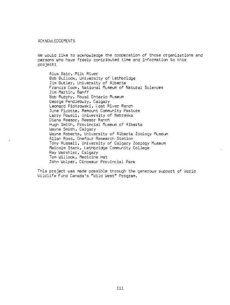
ACKNOWLEDGEME NTS
We would like to acknowledge the cooperation of those organizations and persons who have freely contributed time and information to this project:.
Alva Bair, Milk River Bob Bullock, University of Lethbridge Jim Butler, University of Alberta Francis Cook, National Museum of Natural Sciences Jim Martin, Banff Bob Murphy, Royal Ontario Museum George Pendlebury, Calgary Leonard Piotrowski, Lost River Ranch June Picotte, Remount Community Pasture Larry Powell, University of Nebraska Diana Reesor, Reesor Ranch Hugh Smith, Provincial Museum of Alberta Wayne Smith, Calgary Wayne Roberts, University of Alberta Zoology Museum Allan Ross, Onefour Research Station Tony Russell, University of Calgary Zoology Museum Malcolm Stark, Lethbridge Community College Ray Wershler, Calgary Tom Willock, Medicine Hat John Wolper, Dinosaur Provincial Park
This project was made possible through the generous support of World Wildlife Fund Canada's "Wild West" Program.
iii

1 .0 I NTRODUCTION
In the spring of 1986, World Wi ldlife Fund Canada announced the start of "Wild West", a major conservation initiative in the Grasslands and Parklands of the prairie provinces. As part of this program, research on Alberta's amphibians and reptiles began in the spring of 1986 . The informati on gathered is pro viding direction for further research programs and for conservation of rare and endangered species and critical habitats.
This report is intended to provide brief overviews on the status of all reptiles and amphibians occurring in the Grassland and Parkland na t ural regions of Alberta . The ecosystems of these natural regions are considered "endangered" or "threatened" in Canada (Wallis 1986).
To dat e there has been little published on the habitat and distribut i on of reptiles and amphibians in Alberta. At the Workshops on Rare and Endangered Species in the Prairie Provinces held in January 1986, it was noted that six of the fourteen species found in these regions are of special concern because of rarity or recent declines.
Major impacts on reptile and amphibian habitat include cultivation of nati ve grasslands, draining of wetlands, disturbance of wetlands by livestock , and the killing of snakes at hibernacula. There are no amphibians or reptiles currently protected under Alberta wildlife legislation and, wi th the excepti on of Wr iting-on-Stone and Dinosaur Provincial Parks, l i t t le of their crit i cal habitat is "protected". Though reduced somewhat from previous decades, cultivation of uplands and drai nage of wetlands continues and new ways are being researched t o convert nat ura l habi t ats to cropland.
In Alberta's draft policy document on threatened wildlife, the Alber t a government makes provis ion for legal protection for rare species of r ept i les and amphi bians. This would allow the restriction of dis t urbances and land use activities as well as the formulation of guidelines t o reduce impacts and active management progr ams . Two reptile species, Eastern Short-horned Lizard and Wes tern Painted Turtle, are onl y considered "peripheral" in this draft policy. The Plains Hognose Snake, Tiger Salamander and Northern Leopard Frog are placed in a "status undetermined" category.
The following were goals for the 1986 studies which were funded under the Wild West program:
1 . To describe the known range of all reptile and amphibian species occurring in Alberta's Grassland and Parkland natural regions.
2. To document and map all observations or collections of all rare reptiles and amphibians in Alberta's Grassland and Parkland.
ALBERTA STATUS OF AMPHIBIANS AND REPTILES - OVERVIEW

3. To describe the known habitat of all species, and to highlight any critical habitats.
4. To document major declines in species such as the Leopard Frog .
5. To assess the existing and potential threats to each species.
6. To recommend research, management, or conservation action for the protection of reptiles and amphibians and any critical habitats.
7. To conduct field investigations on at least three of the rarest or most poorly known species in Alberta: Plains Hognose Snake, Western Painted Turtle, and Great Plains Toad.
Rare species or species of concern which were assessed in this project included:
Western Painted Turtle Plains Hognose Snake Eastern Short-horned Lizard Great Plains Toad Northern Leopard Frog
More common species which were also researched included:
Red-sided Garter Snake Plains Garter Snake Wandering Garter Snake Prairie Rattlesnake Bull Snake Blotched Tiger Salamander Boreal Toad Dakota Toad Wood Frog Boreal Chorus Frog Plains Spadefoot (considered a species of concern by Butler &
Roberts 1986)
2
The species accounts were prepared from a review of the literature, from the authors' unpublished field notes, from interviews with people from a variety of backgrounds who had unpublished information on the various species, and from collection information in the Nat ional Museum of Canada, Royal Ontario Museum, University of Alberta Museum of Zoology, University of Calgary Museum of Zoology, and Provincial Museum and Archives of Alberta. In addition, a volunteer field program was carried out by the authors in order to gain more information on species most at risk: the Western Painted Turtle, Plains Hognose Snake, and Great Plains Toad.
Personnel involved in the field work and the preparation of species'
ALBERTA STATUS OF AMPHIBIANS AND REPTILES - OVERVIEW

3
accounts included : Wayne Roberts , Cl i ff Wallis, Cl eve Wershl er , Geor ge Pendlebur y, and Ra y Wershler. Larry Powell assis t ed by providing us wi th a copy of his unpubl ished s t atus repor t on Shor t - horned Lizards in Canada ( see copy attached ) and in reviewing the fina l manuscri pt .
ALBERTA STATUS OF AMPHIBIANS AND REPTILES - OVERVIEW

2.0 FIELD PROGRAM
Field work undertaken included the following:
1. surveys of sandhill vegetation in the Milk River-Lost River and Middle Sand Hills-lower Red Deer River areas for Western Hognose Snakes;
2. surveys of sandy areas in the Milk River-Lost River and Middle Sandhills-lower Red Deer River areas for Great Plains Toads; and
3. a survey of oxbow lakes along the Milk River for Western Painted Turtles.
4
Following two summers of drought conditions in southeastern Alberta, the summer of 1986 was quite wet in the Milk River-Lost River area. Many ponds, some of which had been dry for years, filled up with water. However, amphibian populations, including those of the normally common Chorus Frog, remained quite low. Moisture levels in the EmpressBindloss area continued to be down, with little rain falling until late summer. All of the ponds known to be previous breeding sites of the Great Plains Toad were dry.
The following is a more detailed itinerary of the field program undertaken in 1986:
May 29 (evening) - listened for Great Plains Toads from Lost River area north to east of
Medicine Hat; none were heard (C.Wallis, C. Wershler)
May 3D (morning) - drove roads in Hilda-Empress-Bindloss area, looking for Western
Hognose Snakes; none were found (C. Wallis, C. Wershler)
May 30 (afternoon) - searched Remount Pasture area for Plains Hognose Snakes; none were found - inspected ponds south of Bindloss where Great Plains Toads had bred in
the past; they were dry (C. Wallis, C. Wershler)
June 28 roads driven in Empress-Remount Pasture-Bindloss-Jenner area in search of Plains Hognose Snakes; none were found (C.Wallis)
June 3D (evening) - listened for Great Plains Toads in Bindloss-Remount Pasture area; none
were heard (C. Wershler, R. Wershler)
ALBERTA STATUS OF AMPHIBIANS AND REPTILES - OVERVIEW

July 1 (mor ning and afternoon) searched for Plains Hognose Snakes and Great Plains Toads in Remount Pasture area; none were found (C.Wershler, R. Wershler )
July 6 to 9 - searched for Great Plains Toads and Plains Hognose Snakes in Lost
River-Miik River area; none were found (C. Wershler, R. Wershler)
July 7 - checked Milk River oxbow lake east of town of Milk River (C. Wallis)
July 28
5
- drove roads in Empress-Remount Pasture-8indloss-Jenner area in search of Plains Hognose Snakes; none were found (C. Wallis, C. Wershler)
Augus t 1 to 2 - searched Remount Pasture area for Hognose Snakes; also drove roads i n
Empress-Middle Sand Hills-Bindloss-Jenner area; none were found (G. Pendlebury, C. Wallis)
August 28 - oxbows checked along Milk River for Western Painted Turtles; no
turtles were found but oxbow lake at Pinhorn Grazing Reserve headquarters looked like suitable habitat (C. Wershler)
September 23 - oxbow checked along Milk River (east of Milk River townsite);
unsuitable alkaline habitat (C. Wallis)
ALBERTA STATUS OF AMPHIBIANS AND REPTILES - OVERVIEW

6
3.0 SIGNIFICANT HABITATS
The most important habitats for the majority of reptiles and amphibians in the parkland and grassland are natural environments. Many species are eliminated with cultivation of native vegetation and drainage of wetlands. Of these natural habitats, three are considered to be the most critical for the rarest species:
1. sand plain and sand hill vegetation and associated wetlands, especially in the warmer, drier parts of the Mixed Grassland.
2. extensive bedrock outcrop and badland areas found along the major stream valleys and coulees in the Mixed Grassland.
3. oxbow lakes along the Milk River.
Extensive, relatively undisturbed sand hill and sand plain areas occur in the Milk River-Lost River, Pakowki Lake, and Middle Sand Hills districts. These areas are important or potentially important for Great Plains Toads and Plains Hognose Snakes. Wetlands in many sand plain districts have been cultivated.
Many grassland amphibians are adapted to withstand periods of drought and may not breed during dry years. However, prolonged drought combined with mortality from disease and predators may result in the temporary elimination of amphibian populations. There exists the possibility for "centres of dispersal" -- wetlands which provide critical habitat for amphibians during these extended periods of drought. When ample precipitation returns these could serve as centres from which survivors repopulate habitats which suffered through the drought. This concept has not been studied but amphibians are known to move locally following and during periods of rainfall. It may take several years following a severe drought for a species to repopulate parts of its range. However, if the centres of dispersal were destroyed, then entire districts could lose their populations of these amphibians. There is a need to identify those wetlands which perennially support amphibian populations, particularly the rarer species like the Great Plains Toad.
The most extensive rock outcrops and badlands are found along the South Saskatchewan River, the Red Deer River at Dinosaur Provincial Park, and along the Milk River at Writing-on-Stone Provincial Park and the Milk River Canyon. Some of these areas are important for Short-horned Lizards and all provide critical overwintering hibernacula for several species of snakes. The continued availability of "safe" hibernacula is probably the most critical limiting factor for snakes in Alberta. Some species, notably the garter snakes, are able to overwinter in mammal burrows while others, like the Bull Snake and Prairie Rattlesnake, see'm to be dependent on major rock outcrops or extensive badland formations. No overwintering hibernacula of Plains Hognose Snakes have been
ALBERTA STATUS OF AMPHIBIANS AND REPTILES - OVERVIEW

7
described for Alberta .
Oxbow lakes along the Milk River are critical habitats for Western Paint ed Turtles. These habitats are very limited in extent and many dry up when there are insufficient floodwaters or when the main river channel becomes too separated from the oxbow lake • Regular flooding and creation of new oxbow lakes are crucial to Western Painted Turtle habitat maintenance.
ALBERTA STATUS OF AMPHIBIANS AND REPTILES - OVERVIEW

4.0 RECOMMENDATIONS
Research
Our knowledge of amphibians and reptiles in Alberta is still sketchy. There should be greater encouragement and support for naturalists, university researchers, and other interested parties who wish to study Alberta species and habitats.
The most pressing research needs include:
8
1 .· an assessment of Great Plains Toad and Plains Hognose Snake populations and habitat in the Middle Sand Hills area of the Suffield Military Reserve and adjacent lands. For the same cost, populations of Ord's Kangaroo Rats could also be identified as they occur in the same general area. Information would be used to gain status for the most significant sites so they can be protected or actively managed. Estimated cost: $5000.
2. identification of hibernacula locations in the drier Mixed Grassland region based on local residents' information. This could be a combined mail-out questionnaire and follow-up interview program such as that conducted by Pendlebury in the mid-1970's for Prairie Rattlesnakes. The goal would be to raise the public profile of snake hibernacula and information gained would be used to establish protected sites. Estimated cost: $3000.
3. population assessment of Western Painted Turtles -- this would include a survey of newly formed oxbow lakes as well as a resurvey of previously used sites, and interviews with Cypress Hills residents. Information collected would be useful for potential reintroduction programs. Estimated cost: $750.
4. an assessment of Great Plains Toad numbers in natural and irrigated lands in the Hays-Vauxhall-Lake Newell district. Information gathered here could be useful in management of Great Plains Toad habitat. Estimated cost: $1500.
s. feasibility study for reintroduction of Northern Leopard Frogs, including identification of suitable pilot project areas for supply and release, and sites and procedures for initiating a long-term monitoring program. Estimated cost: $1500.
6. television spots on native amphibians and reptiles, using donations of existing slides and footage. Estimated production cost: $1200/spot.
Longer-term research needs are identified in the species' accounts.
ALBERTA STATUS OF AMPHIBIANS AND REPTILES - OVERVIEW

Habitat Protec t i on
Efforts should be made in planning programs to ensure the long-term protection of the most critical habitats: sand hill/sand plain areas and associated wetlands; extensive bedrock outcrops and badlands; and oxbow lakes.
9
In general, conservation of the few rema1n1ng significant tracts of native grassland and parkland as well as major wetlands will ensure the maintenance of many of the native amphibians and reptiles. To support this goal , some demonstration projects could be:
1 • the establishment and wise management of the Kennedy Creek/Milk River Canyon natural area/ ecological reserve .
2. the protection of t he natural habitats of the Middle Sand Hills (Suffield Military Reserve) under a National Wildlife Area designation.
3. the establishment and wise management of the proposed Wainwright (David Lake) ecological reserve.
Legislation
Greater legislative protection should be provided for known critica l habitats such as hibernacula and endangered or threatened status should be provided for the rarest species:
1 • Western Painted Turtle - Endangered 2. Easter n Short-horned Lizard - Threatened 3. Plains Hognose Snake - Endangered (each of the colour phases) 4. Great Plains Toad - Endangered 5. Northern Leopard Frog - Threatened
Other Conservation Mechanisms
Suitable habitat for many reptiles and amphibians is maint ained in many Provincial and National Parks as well as in natural areas and proposed ecological reserves. However, many of the most significant habitats have not been identified and there is often no formal review of developments which could affect these areas. The Natural Areas Program in Alberta has initiated studies and active management of environmentally significant sites. It is proposed that Alberta Recreation and Parks and Parks Canada also embark on programs for the identification and management of environmentally significant areas, including reptile and amphibian habitats. This will ensure long-term protection of the valuable areas managed by these agencies.
ALBERTA STATUS OF AMPHIBIANS AND REPTILES - OVERVIEW

10
Program Coordination
Alberta Fish and Wildlife has the mandate to coordinate conservation action programs for Alberta's reptiles and amphibians. It is important that they expand the protection of reptiles and amphibians through policy and legislation and that they provide the necessary manpower and funding to facilitate research and habitat conservation. They can also play a significant role in public awareness and education programs.
ALBERTA STATUS OF AMPHIBIANS AND REPTILES - OVERVIEW

5.0 SPECIES' ACCOUNTS
The following headings are listed in every species' account:
1 . Latin name 2. common name 3. brief summary of status 4. habitat 5. threats 6. population size and trend 7. protective status 8. recommendations/ management action
For the common species, general range maps and a note on their general distributions have also been prepared. For rare species, all known collections and observations are documented and mapped.
The approximate limit of the main range is denoted by a solid line.
1 1
Dot s indicat e actual collection or observation localities -- these are used for rare species and have also been used for more common species to denote isolated occurrences outside the main range, more restricted patterns of distribution within a general range, or to place exact locations for range limits. Open circles refer to unconfirmed reports.
Noteworthy references for Alberta records are listed .
ALBERTA STATUS OF AMPHIBIANS AND REPTILES - OVERVIEW

12
LATIN NAME : Ambystoma tigrinum melanostictum
COMMON NAME: Blotched Tiger Salamander or Tiger Salamander
BRIEF SUMMARY OF STATUS:
Widespread and relatively common throughout the Grassland and Parkland regions of southern and central Alberta.
GENERAL ALBERTA DISTRIBUTION:
Occurs throughout the Mixed, Northern Fescue and Foothills Grasslands and the Foothills and Central Parkland, from the United States boundary north to Barrhead region at the southern edge of the Mi xed Wood Boreal Forest, and from the Saskatchewan boundary west to the edge of the Foothills and Rocky Mountains.
HABITAT:
Semipermanent and permanent ponds, lakes and streams. Outside the breeding season, Blotched Tiger Salamanders spend considerable time underground in burrows of mammals such as the Richardson's Ground Squirrel.
THREATS:
Drainage and cultivation of wetlands; the impact of disposal of various chemicals from oil and gas exploration and of catt l e activity on breeding ponds has not been researched. There is a significant mortality on highways associated with their mass migrations following or during rain. The impact of ground squirrel declines in parts of the Grassland region is unknown.
POPULATION SIZE AND TREND:
Blotched Tiger Salamanders appear to be common in Alberta and populations appear to remain at healthy levels despite some local losses due to wetland destruction.
PROTECTIVE STATUS:
Blotched Tiger Salamanders occur in numerous Provincial Parks in which wetland areas receive a measure of protection. This species is lis t ed as "status undetermined'' in "A Draft Policy for the Management of Threatened Wildlife in Alberta".
RECOMMENDATIONS/MANAGEMENT ACTION:
Protection of wetlands for other wildlife will benefit t his species.
A distinct subspecies Ambystoma tigrinum diaboli, the Grey Tiger
BLOTCHED TIGER SALAMANDER AMBYSTOMA TIGRINUM

Salamander, may occur in east-central Alberta along the Saskatchewan border. Researchers in this area should be on the lookout for this f orm.
Concern has also been expressed for the protection of wetlands which support neotenous Blotched Tiger Salamanders. These are salamanders which re.main in a juvenile gilled condition throughout their entire lives and can grow to lengths which exceed 300 mm. They require an absence of predatory fishes and the water t o be sufficiently deep to escape freezing.
REFERENCES:
Butler and Roberts (1986)
13
BLOTCHED TIGER SALAMANDER AMBYSTOMA TIGRINUM

•
0
u
" •
..
" •
Ambystoma tigrinum melanostictum
Blotched Tiger Salamander
t 1, J U 1110
' I
·..= :::1 ,..., ''-1-H
-... '+P,=;-' ' ..l"'!!o
r-·,
' .. 0 • T A • •
' '
~-. ·
" I II
'·±Z:f i , I i
I !
' ' ' !
~ I
' ..
14
...

LATIN NAME: Scaphiopus bombifrons
COMMON NAME: Plains Spadefoot
BRIEF SUMMARY OF STATUS:
Very local but sometimes common in suitable habitats in the Mixed Grassland; rare in the Central Parkland . Butler and Roberts (1986 ) considered it a species deserving "special consideration".
GE NERAL ALBERTA DISTRIBUTION :
15
Occurs through the eastern half of the Mixed Grassland from the United States boundary north to the Red Deer River and west to Wri ting-on-St one Provincial Park and Dinosaur Provincial Park; also collected at Barons , Claresholm and Gleichen; known in the Central Parkland only from the Sounding Lake and Dilberry Lake-Reflex Lakes areas .
HABITAT:
Breeds in s hallow water of vernal pools on uplands and along streams , semi-permanent ponds, oxbow lakes and s t ream meander channels. Al l the known records come from natural habitats in areas of sandy glacial outwash, sand dunes or sandy stream channels. Its distribution in cultivated areas is unknown. Stream valley habitats ma y be important during extended periods of drought and ma y serve as reservoi rs for repopulat i on of upland areas.
Breedi ng generally occurs during May but immatures have been not ed in the Ref lex Lakes and Orion districts up to August 22.
THREATS:
Major t hreats are cultivation of wet lands and flood control along ma jor streams. The impact of di sposal of various chemicals from oil and gas exploration and development and of cattle activity on breeding ponds has not been researched.
POPULATION SIZE AND TREND:
Locally common in the Mixed Grassland where they occur in breeding groups of up to several hundred individuals; rare in the Central Parkland where only two breeding localities are known. It is adapted to the vagaries of the grassland climate and may not breed during dry years. However, the Alberta population of Plains Spadefoots appears to decline dramatically after extended periods of drought. Within this natural fluctuation, the Alberta population appears to be "stable" . No long-term declines have been documented.
PLAINS SPADEFOOT SCAPHIOPUS BOMBIFRONS

16
PROTECTIVE STATUS:
Populations occur on protected sites in Dinosaur Provincial Park and Writing-on-Stone Provincial Park. There may be populations at Oilberry Lake Provincial Park where protected status to its habitat could be given. Populations may also receive protection in the proposed Milk River Canyon/Kennedy Creek natural area/ecological reserve.
RECOMMENDATIONS/MANAGEMENT ACTION:
Because its habitat is localized, protection of known breeding habitat from cultivation and other developments should be a priority. Further research should be directed to the location of "centres of dispersal'', areas which may support populations of Plains Spadefoots (and other grassland amphibians) through extended dry periods. The effects of cattle activity on breeding ponds of this and other grassland amphibians should also be studied.
Alberta Parks should be made aware of the significance of populations in their jurisdiction and the need to identify breeding habitat and protect them from developments.
The Middle Sand Hills of the Suffield Military Reserve may be important for this and a number of other grassland reptiles and amphibians. At the present time, this area is out-of-bounds for military activity but is open to oil and gas development. Cooperative conservation approaches with the Suffield Environmental Advisory Committee and the Alberta Energy Company to identify and protect critical habitats could be explored. A suggestion was made several years ago to have this area designated a National Wildlife Area. This proposal was made again last year to Tom McMillan, federal minister of the Environment. Numerous species of wildlife, including several rare types, would benefit from any additional protection which could be afforded this nationally significant area.
The establishment of the Kennedy Creek/Milk River Canyon natural area/ecological reserve would protect populations of Plains Spadefoots.
REFERENCES:
Butler and Roberts (1986) Lewin (1963a) Moore (1952) Wallis (1976) Wallis (1977)
PLAINS SPADEFOOT SCAPHIOPUS BOMBIFRONS

c
•
0
u
z
..
• •
"
Scaphiopus bombifrons
Plains Spadefoot
•
' 4' l ol J
I ' .,L
~ ,,. •• .
.J s1• II
..J.2l
~~ ~·· ! -~~ --..l!.!: ;
' .....,. ,· I 10'
.::!!lo. 2,
17

18
LATIN NAME: Rana pipiens
COMMON NAME: Northern Leopard Frog
BRIEF SUMMARY OF STATUS:
Formerly widespread when it was at least locally abundant; now absent from much of its former range within the Central Parkland even though its habitat remains widespread; reduced populations persist in the Mixed Grassland of extreme southern Alberta. Protection of Leopard Frogs and their reintroduction into suitable habitat is required. This species should be regarded as threatened.
GENERAL ALBERTA DISTRIBUTION:
The main distribution of Northern Leopard Frogs is in the Central Parkland, Northern Fescue Grassland, Foothills Grassland, and Mixed Grassland natural regions. Isolated occurrences are known from the eastern fringes of the Foothills and from the Mixed Wood Boreal Forest north at least to Lesser Slave Lake and, possibly, Fort McMurray. They also occur in low populations on the Kazan Upland Canadian Shield north of Lake Athabasca.
HABITAT:
Adults and transformed subadults occupy open areas along the margins of a variety of waterbodies. This includes shorelines with little or no vegetation such as in the badlands along grassland and parkland rivers, as well as shorelines with well-developed plant communities of grasses, sedges and willows. Northern Leopard Frogs also occur some distance from shorelines in a variety of vegetation which is usually open or only sparsely wooded. Permanent water is a constant feature of the home range occupied by this species as it overwinters under rocks in springs and streams or in shallow depressions on the bottoms of lakes. Leopard Frogs are often associated with water which is clear and not too alkaline.
Spawning occurs in temporary ponds, sloughs, dugouts, borrow pits, the shallow vegetated areas of lakes, backwaters and oxbow lakes of rivers, and beaver ponds where warm standing water provides an environment for the rapid development of eggs and tadpoles. While summer habitat for transformed individuals is widespread, suitable habitat for spawning and overwintering are localized and probably restrict the distribution of Northern Leopard Frogs.
THREATS:
Draining of wetlands the loss of spawning surrounding habitat. affect this species.
NORTHERN LEOPARD FROG
is perhaps the major threat to this species due to and rearing habitat and the dessication of
Natural fluctuations in the water table similarly Leopard Frogs have been collected elsewhere for
RANA PIPIENS

19
biological supply houses and as fish bait. Such harvest in Alberta is not warranted with the present restricted range and small populations of Northern Leopard Frogs. Toxic substances, including a variety of agricultural chemicals such as Atrazine, have been identified as a possible cause of declines in Wisconsin populations of this species (Hine et al 1981) while low pH from acid rain is known to adversely reproduction of Northern Leopard Frogs (Schlicter 1981 ) .
POPULATION SIZE AND TREND:
Populations of Northern Leopard Frogs in central Alber t a declined or crashed during the late 1970's (Roberts 1981 ). A decline was also noted in Saskatchewan (0. Secoy, personal communication ). Much of the former range in central Alberta, including the middle reaches of the Red Deer River drainage appears to be devoid of this species. Populations in the south range from few or none along the St. Mary's Ri ver to locally abundant along the Milk Ri ver and at least one site on the lower Red Deer River (C. Wallis and C. Wershler, personal communication). Most southern populations appear to be reduced.
No single explanation has been found for the dramatic decline of this species in Alberta. While a decline in the water table and low winter water flows in ri vers would have reduced or eliminated spawning and overwint ering habitats in certain areas, this does not account for disappearances of populations from spring rich areas such as t he Clearwater River/North Saskatchewan River near Rocky Mountain House and Kilini Creek northwest of Edmonton.
It is possible that epidemics of "Red Leg" ma y have caused high mortali ty of overwintering Northern Leopard Frogs. This disease is caused by Aeromonas hydrophila, a bacterium widespread in North America and Europe which affects fish and amphibians (Emerson and Norris 1905) . At least half of the infected Leopard Frogs die (Reichenbach-Klinke and Elkan 1965 ) and in laborator y populations it ma y be 100% fatal (Hunsaker and Potter 1960) . It is evident from the observations of Hine et al (1981) that "Red Leg" is a factor in the decline of the NorthernLeopard Frog in Wisconsin where large numbers perished during the fall and winter.
While Roberts (1981) did not discuss the role of this disease in the decline of Northern Leopard Frogs in Alberta, massive mortality of individuals displaying symptoms of this disease occurred in populat ions overwintering in springs along the Clearwater River during 1976. During low water years numerous frogs ma y have overwintered in a small number of favorable sites where they became infected with "Red Leg".
Healthy populations in certain oxbows of the Milk River and at a spring in the Bindloss area may be indicative of population increases and are perhaps a sign of hope for this species in southern Alberta.
NORTHERN LEOPARD FROG RANA PIPIENS

20
PROTECTIVE STATUS:
This species is listed as "status undetermined" in "A Draft Policy for the Management of Threatened Wildlife in Alberta".
Suitable Leopard Frog habitat occurs in many provincial and national parks throughout southern Alberta. While these receive no active management, formal protection could be given in many areas.
The establishment of the Kennedy Creek/Milk River Canyon natural area/ecological reserve would protect known healthy populations of Northern Leopard Frogs.
RECOMMENDATIONS/MANAGEMENT ACTION:
Populations where abundant Northern Leopard Frogs occur should be monitored to see whether numbers are stable or increasing. Adjacent areas should be surveyed to determine whether or not they are being repopulated. Where populations are small, reproductive success should be studied in selected sites to determine if poor recruitment is responsible for low numbers and poor recovery of these populations.
Roberts (1986) recommended reintroduction of Northern Leopard Frogs to a small number of sites within the known range of this species. This is required as colonization of Alberta probably was facilitated initially by an abundance of water (post-glacial lakes) and natural repopulation of the former range may be a slow process. Reintroduction sites should be characterized by being previously occupied by this species; and have permanent water for overwintering, s uitable spawning and rearing habitat, and access to permit regular monitoring; and be relatively free of disturbance from human activity. These populations may serve as centres of dispersal for surrounding areas.
This is regarded as a "status undetermined" species in Alberta (nonlicense species) but should be regarded as "threatened". Legal protection should be accompanied by an education program pointing out the decline in numbers and requesting assistance in maintaining habitat and minimizing disturbance.
REFERENCES:
Butler and Roberts (1986) Roberts (1981) Roberts (1986)
NORTHERN LEOPARD FROG RANA PIPIENS

c
• :r
0
..
z
..
0:
•
, I
ol I I
I . _.
R~ma pipiens .',
I I
Northern Leopard Frog
I I ' l i t
-- I I I A 01 A
....... ,. ~· , .. ~ ~,
l ...... ...l.!i .J"!o. ,Zid
~: I i I ;
~:-1..,.
" ... _. • I
HI! I
~ · ' ..... __.... ..
21

LATIN NAME: Rana s yl vatica
COMMON NAME: Wood Frog
BRIEF SUMMARY OF STATUS:
22
Common in the northern parts of the Foothills Parkland and Central Parkland, becoming rare further south; absent from the Grassland region.
GENERAL ALBERTA DISTRIBUTION:
Widespread throughout the wooded regions of northern and central Alberta, from the Northwest Territories boundary south to the southern edge of the Central Parkland and t he Porcupine Hills area in the Foothills Parkland, and into the Rocky Mountains along the major stream valleys.
HABITAT:
Semi-permanent and permanent ponds and lakes in wooded regions.
THREATS:
Drainage and cultivation of wetlands.
POPULATION SIZE AND TREND:
Common in much of the more heavily wooded Parkland and there have been no long-term declines noted. There have been some local losses due to wetland destruction, principally at the southern edge of the Parkland.
PROTECTIVE STATUS:
Occurs in numerous Provincial Parks and National Parks.
RECOMMENDATIONS/MANAGEMENT ACTION:
Protection of wetlands for other wildlife will benefit this species.
WOOD FROG RANA SYLVATICA

,,..
• :r
"
0
u
..
• •
~ sylvatica
Wood Frog
.... T 111.
R I T 0 R I I __:_•-----''~ \ !1
I : \ ~
'~~~----l~L--------r~---~~~'·· II ·, II .,. II
I)
.. ..
23
a

24
LATIN NAME: Bufo cognatus
COMMON NAME: Great Plains Toad
BRIEF SUMMARY OF STATUS:
Should be considered endangered; very rare and very local in the Mixed Grassland region of Alberta.
GENERAL ALBERTA DISTRIBUTION:
Sand hills and sand plains in the Red Deer River-Suffield Military Reserve-South Saskatchewan River, Taber-Lake Newell, and Lost River-Milk River areas.
SPECIFIC LOCALITIES:
- collection at the Royal Ontario Museum:
Medicine Hat, June 8, 1928, T. Kurata
- collections at the National Museum of Canada:
Medicine Hat, south golf course, slough by green, emerging from cracks in ground, also in grass and bare ground everywhere around the slough edge, 124 immatures, June 28, 1957; 20 individuals, July 7, 1957, S. S. Bleakney and F.Cook
- collections at the University of Alberta Museum of Zoology:
Lost River, Aug 19, 195D, R. Lister Medicine Hat, July 16, 1951, R. Lister & J. Moore Empress, exact location unclear, July 12, 1951, J. Langmuir Suffield, exact location unclear, July 16, 1951, J. Moore Taber, exact location unclear, August 1951, W. Saskow Vauxhall, exact location unclear, August 1951, W. Saskow 25 mi S of Empress, June 21, 1970, N. Panter 9 mi Wand 20 mi S of Empress, June 24, 1971, N. Panter & V. Lewin S end of L Newell, June 3, 1979, V. Lewin 3 mi S of Hays, June 9, 1982, V. Lewin, collected in spawning congress
- collections at the Provincial Museum of Alberta:
Hilda, S14-Tp 19-Rge 2-W4, June 16 and 17, 1970 and June 23, 1969, seven collections; calling in pond with several hundred spadefoots on June 16; sandy area with sage; also caught on road (probably at night), M. Hampson
GREAT PLAINS TOAD BUFO COGNATUS

- other observations:
5 miles south of Bindloss, SE30-Tp 21-Rge 2-W4, several calling in shallow water of pond dominated by Polygonum, in sandy kame moraine, May 27, 1976, recordings made, C. Wallis
7 miles south of Bindloss, NW8-Tp 21-Rge 2-W4, two calling in shallow water of small pond, sandy kame moraine, May 2, 1978, photographs taken, C. Wallis, C. Wershler, R. Wershler
Bindloss bridge, Tp 22-Rge 3-W4, 1 very small Great Plains Toad, July 18, 1974, W. Smith
25
White Rock Coulee area, South Saskatchewan River, Tp 17-Rge 3-W4, small slough on upland, several calling with Chorus Frogs, May 29, 1974, W. Smith
Lost River, SE3-Tp 1-Rge 4-W4, May 19, 1981, C. Wallis, C. Wershler Empress, possibly in Saskatchewan, along the Red Deer River, several
calling with numerous Plains Spadefoots, May 24, 1974, W. Smith 10 miles SW of Empress, N20-Tp 21-Rge 1-W4; 1 calling on May 3, 1976, C.
Wallis, W. Smith; again on June 15, 1979, several calliog in small shallow pond at edge of sand hill area, C. Wallis
Lost River Ranch, Tp 1-Rge 5, 1 calling, May 14, 1975, C. Wallis, W. Smith
Lost River Ranch, NE10-Tp 1-Rge 5-W4 , calling in small shallow pond in sandy outwash plain, May 21, 1978, C. Wallis, C. Wershler
South Saskatchewan, Tp 18, Rge 3, W. Smith, dugout Lost River, Tp 1, Rge 4, W. Smith
-observations by June Picotte, Remount Community Pasture, Tp 21-Rge 3-W4:
Great Plains Toads have been heard calling from a dugout to the SW of the headquarter buildings and have also been seen in the vicinity of the buildings and in the garden. One was photographed being swallowed by a Plains Hognose Snake. The Remount headquarters are located in a large tract of unbroken native grassland on sand hill terrain.
HABITAT:
Vernal pools and semipermanent ponds, rarely in lakes; in sand hills and sand plains. It is unclear whether the Vauxhall and Taber records were from natural or irrigated areas -- few natural wetlands persist in these areas today.
In Oklahoma, Bragg (1940) noted that Great Plains Toads bred only after rain in spring or summer when the temperature exceeded 12°C. He also stated that they did not breed in excessively muddy water, even though the young tadpoles may have been later subjected to disturbance by buffalo wallowing in the pools. While clear water was a requirement for breeding, it did not seem to be necessary for successful development of the young. All breeding records by Wallis, Smith, and Wershler for Alberta are-in relatively clear water in areas which were not being grazed at the time of breeding.
GREAT PLAINS TOAD BUFO COGNATUS

26
In Alberta, Great Plains Toads breed in May and early June.
THREATS:
The major threats are drainage and cultivation of wetlands. The impact of disposal of various chemicals from oil and gas exploration and of cattle activity on breeding ponds has not been researched.
POPULATION SIZE AND TREND:
The population in Alberta is very low. An extended period of drought over the last few years has dessicated most of the Great Plains Toad's known breeding ponds. In J986, no breeding was noted in the BindlossMiddle Sand Hills or Lost River areas. Drought persisted beyond the breeding season in the former area but it is possible that breeding occurred in early summer at Lost River following an unusually wet late spring. Above normal precipitation fell over most of southern Alberta in late summer and fall and it is possible that breeding ponds may have adequate water next spring. At least two former breeding ponds have now been cultivated.
PROTECTIVE STATUS:
No protected areas containing populations of Great Plains Toads are known in Alberta. This species is not listed in Alberta Fish and Wildlife's "A Draft Policy for the Management of Threatened Wildlife in Alberta".
RECOMMENDATIONS/MANAGEMENT ACTION:
During wetter years, there needs to be further research to determine the locations of breeding ponds. Research should also be directed to the location of "centres of dispersal'', areas which support populations of Great Plains Toads (and other grassland amphibians) through extended dry periods. Research should be done in cooperation with any Saskatchewan surveys in the Great Sand Hills. The most extensive potential Alberta habitat lies adjacent the Great Sand Hills and repopulation of some Alberta ponds may rely on Saskatchewan wetlands or vice versa.
Because its habitat is highly localized, protection of known breeding habitat from cultivation and other developments should be a priority. Grazing should be eliminated from known Great Plains Toad ponds during the breeding season.
The Middle Sand Hills of the Suffield Military Reserve may be important for this and a number of other grassland reptiles and amphibians. At the present time, this area is out-of-bounds for military activity but is open to oil and gas development. Suggestions have been made to have this area designated a National Wildlife Area (see note under Plains Spadefoot). Numerous species of wildlife, including several rare types, would benefit from any additional protection which could be
GREAT PLAINS TOAD BUFO COGNATUS

27
afforded this nationally significant area.
The Vauxhall-Lake Newell-Hays population should be studied to determine the impact of irrigation and agriculture on populations of Great Plains Toads.
In January 1986 it was recommended by participants at the Edmonton workshops on Rare and Endangered Species that the Great Plains Toad be listed as "threatened" and possibly "endangered" in Alberta. It is the authors' view that this species should be classified as ''endangered" under appropriate provincial wildlife legislation.
REFERENCES:
Butler and Roberts (1986) Logier (1931) Moore (1953a) Lewin (1963a) Wallis (1976) Wallis (1977)
GREAT PLAINS TOAD BUFO COGNATUS

t u • T l ~ T 0
..
•
0
u
. - .. ·- -·-. :r
..
•
'T I •
~··~ . ,. I
.... ...
" · :·
" .. II
"
28
•
•
n
•
z

29
LATIN NAME: Bufo americanus hemi ophrys
COMMON NAME: Dakota Toad or Canadian Toad
BRIEF SUMMARY OF STATUS:
Common throughout the Central Parkland, becoming more localized furt her south in the Northern Fescue Grassland; rare in the northern part of the Mixed Grassland.
GENERAL ALBERTA DISTRIBUTION:
Widespread through the eastern wooded portions of Alberta from t he northern part of the Mixed Grassland along the Red Deer River north at l east to the Peace-Athabasca delta and Lesser Slave Lake areas.
HABITAT: .
Permanent ponds, lakes, oxbow lakes, old meander channels, and slow-moving streams; generally in relatively clear water.
THREATS:
Drainage and cultivation of wetlands; flood control along major streams.
POPULATION SIZE AND TREND:
Common throughout much of the Central Parkland and Northern Fescue Grassland, especially the eastern portions; confined to irrigation districts and the Red Deer River in the Mixed Grassland. Dakota Toads appear to be maintaining themselves at healthy levels despi t e some l ocal losses due to wetland destruction.
PROTECTIVE STATUS:
Dakota Toads occur in numerous Provincial Parks and Elk Island National Park.
RECOMMENDATIONS/MANAGEMENT ACTION:
Protection of wetlands for other wildlife will also benefit this species.
DAKOTA TOAD BUFO AMERICANUS HEMIOPHRYS

..
•
•
• I
0
.. - ---- -,
z ··-,
- - :0. . . -. - . - . ·--- :-<r70 1!1 I J. a, J .. \
ilL ~-: ___ :~~J: _ :·: / : ~ - ---: :~ . :: tr- : . ·: I 1 • • -- • •• • • - • • • ~~-~ . - r-~ • -.. - • ' ...
h- --:-1 ' ' . I, • ' -:-+---.- - ~~~-- - .-.;c-:::_ ~ . . . r- . - . . . - . . .. r-7 . .. . ' - . ' . I ' • ! - . ')..,;:r(:::-. . - - j•C ::;::; -·. ~ : - : :: : - ;.....:..... ·- ~ ~ L
1 n:..t-f+l--~ . · --- ···---=-t. -- -- ·- '' ' r- · r-T-: · · ·- · · : ~ . I . ~UL· I : -- - . .. ' - ·-:- • -'--1 . - ....
tf-rr-. • -1---Ll-.:.;:. , · :::u_-; ·~ ~~· ~ - · ~ --~ - ::.._ T . ... --- •; · -- · :• CJ2:7I], . . ' -.4_ ... • ' · " • • I I I • . - . ' •
' '
• ' +--i-l.!. ~~· · -· ··_:"
: · j-o----,:.... _;., , '. ~- --;\·: 'Y".L, . :~- =_:- :_~ ---:.: . .. . ,. 1 !! ' _~- lfTi~.!-! ' ..:.....L:: ... ------ ·;[=-~'r';-'(..~r - · ' f.'i. ··n ·,·,·., , ,.. .. ___ .. . ~ ' :.""'!' ' ' ·~"' '"; .,·,;--,r, ;'Tr . .-,. , .. -, ,-,-;, , "' "'' '"" •· '"""'' "' ' , ~~ --:1= -~ ~ . .L --..:L'!. - · ' ' ;::'___,___,_ ~ - . . ! t ' • .. .. .. ---... -. -~::.-=-. ' . ---··-·-----L_ --ro- · +-,T7l-~ I r; ~~- --~. ~ -· . -------;;t!-. - &(· - -· . ::-:-_- -:-..:-:-_ •. ----- • !)1 l: : . J-: ~ ~ +-4--: ·~ ..
- ::.::. ... ~=:...:..:·· - l., .. ..; :.~ ~+h-:·+. ' . ~~ .. ._ _ _ _ _ _, - ... """' ' . ' ..!.'Y. . ........ . -~ ~ + f-!--l · "Fe~ ; z ~ . ' Ltll .Y ! _l'\ ,........... . ' ij"" r--.. -:-:-:.:-·-~~ ---~--- · ~ . -"-n~ ,. '-:--:t_ , .. __ .. :-::.~-~-==;,.c~--- . \ . y .!'!. • ' '' . - - . .... ~-:. - _____ _.. . • ...dl ~__._~ . ~ :. • •
\.~~ i -- ·--- ' ' . . .... :...~ --:_:_-·)-- ~~-~;=~d~ , -j:t-~?.:-~,W I ' 1
.:Ti ~· ' ' I . I ' . J' '•:, ·~ .~ ~}ot_;, ~ \. - (" · . ' '•. • • I ~ ~· '+-h __,...,
I . .~ .. ... .. ·-+ ~ ' , ... j -~.... -2'::· --~z~r'-· ~ -~~ ~ _-\- :~
_j ll ! ..:.'_' •
''· I -..., .
I o
•
. . '"" ~-=
- .. Bufo americanus hemiophrys
rll: " •
Dakota (Canadian) Toad ·.l( ·
' ....
30

31
LATIN NAME: Bufo boreas boreas
COMMON NAME: Boreal Toad or Western Toad
BRIEF SUMMARY OF STATUS:
Rare in the Foothills Grassland region; but common in the Foothills and Rocky Mountain Regions.
GENERAL ALBERTA DISTRIBUTION:
Foothills and Rocky Mountains from the United States border north int o the Peace River district. There are also records from Calgary and widely disjunct occurrences at Del Bonita and Hays in the Foothills Grassland and Mixed Grassland.
HABITAT:
Beaver ponds and other permanent wetlands in wooded areas. They apparently also occur along major rivers well into the grasslands. It is not known if these are viable breeding populations or individuals which have been transported downstream in floodwaters.
THREATS:
There is insufficient knowledge of grassland populations to assess the threats.
POPULATION SIZE AND TREND:
Undetermined in grassland environments.
PROTECTIVE STATUS:
Protected in several national and provincial parks; no protection for grassland populations.
RECOMMENDATIONS/MANAGEMENT ACTION:
More research is needed to determine the extent and significance of this species' occurrence in the grassland region.
BOREAL TOAD BUFO BOREAS BOREAS

c
•
0
..
" •
• •
~-
- · --~ - -'·
, ..
~ boreas boreas
Boreal (Western) Toad
L ~ · __..:_~
- ·~-·, ,, r: •1
1 1 1 , t .. U It I I 1. . 1
' ..J.
-' • T " . ..
·~ ; ~ ·. ·!a ... .~
· · ·~ ..d ~ ..
... ..... ~ ' ~-
~~ ' l
1 I I i ~ '
' .. ' ·• ·' • ..
.:j . ...; -; - ..
32

LATIN NAME: Pseudacris triseriata maculata
COMMON NAME: Boreal Chorus Frog
BRIEF SUMMARY OF STATUS:
Abundant.
GENERAL ALBERTA DISTRIBUTION:
Found in most areas of Alberta, except in the Main Ranges and higher elevations of the Rocky Mountains.
HABITAT:
A variety of vernal pools, and semi-permanent and permanent wetlands; along stream valleys and in uplands.
THREATS:
None.
POPULATION SIZE AND TREND:
33
Chorus Frogs are abundant throughout the Parkland and Grassland regions . It is maintaining healthy populations in all but the most extensivel y and intensively cultivated areas of Alberta. Populations appear to build up rapidly following periods of drought.
PROTECTIVE STATUS:
Boreal Chorus Frogs occur in numerous Provincial Parks and National Parks.
RECOMMENDATIONS/MANAGEMENT ACTION:
None required. Protection of wetlands will benefit this and other wildlife species.
CHORUS FROG PSEUDACRIS TRISERIATA
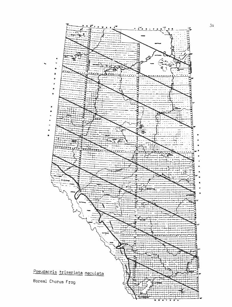
34
• ...
• • "
0
u
•
..
• • •
• •
•
t
• •
Pseudacris triseriata maculata
Boreal Chorus Frog

35
LATIN NAME: Chrysemys picta belli
COMMON NAME: Western Painted Turtle
BRIEF SUMMARY OF STATUS:
Should be considered endangered; very local and very rare in Alberta, occurring here at the northern limit of its range.
GENERAL ALBERTA DISTRIBUTION:
Naturally occurring only along the Battle Creek in the Cypress Hills. Creek drainage in Saskatchewan and Montana.
SPECIFIC LOCALITIES:
lower Milk River and, possibly, This species occurs along the Battle
along the Missouri River drainage in
Cypress Hills, photographed at Battle Creek at Reesor's Ranch, summer 1979, J. Martin; also one recorded several years previous
- collection at the National Museum of Canada:
Milk River at mouth of Verdigris Coulee, summer 1967, T. Willock
- collections at the University of Alberta Museum of Zoology:
Milk River 17 mi west of Wildhorse, oxbow lake with much emergent vegetation, primarily cattails, bulrushes, and sedges, with several large partly submerged tree trunks which were used for basking, old claw marks from past years indicated several years of use, June 6, J. Ryder and V. Lewin and June 7 and 19, 1962, V. Lewin
Milk River Canyon oxbow lake (about 2 miles west of previous site), S5-1-5-W4, July 1975, 3 sight records, W. Smith and C. Wallis; again July 1976, 2 sight records, C. Wallis, C. Bradley, L. Bradley, G. Langford
There are numerous records of introductions including a Coleman/Blairmore population which may persist in several ponds, as well as some at Calgary, Grimshaw, Hines Creek, and Edmonton.
HABITAT:
Oxbow lakes and, possibly, ponds or slow-moving streams in the Cypress Hills.
THREATS:
Flood control from upstream dams.
WESTERN PAINTED TURTLE CHRYSEMYS PICTA BELLI
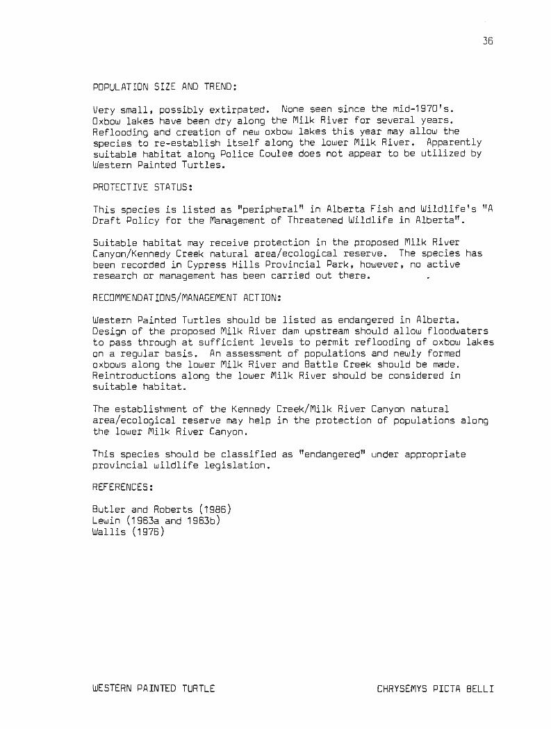
POPULATION SIZE AND TREND:
Very small, possibly extirpated . None seen since the mid-1970's. Oxbow lakes have been dry along the Milk River for several years. Reflooding and creation of new oxbow lakes this year may allow the species to re-establish itself along the lower Milk River. Apparently suitable habitat along Police Coulee does not appear to be utilized by Western Painted Turtles.
PROTECTIVE STATUS:
36
This species is listed as "peripheral" in Alberta Fish and Wildlife's ''A Draft Policy for the Management of Threatened Wildlife in Alberta".
Suitable habitat may receive protection in the proposed Milk River Canyon/ Kennedy Creek natural area/ ecological reserve. The species has been recorded in Cypress Hills Provincial Park, however, no active research or management has been carried out there.
RECOMMENDATIONS/MANAGEMENT ACTION:
Western Painted Turtles should be listed as endangered in Alberta. Design of the proposed Milk River dam upstream should allow floodwaters to pass through at sufficient levels to permit reflooding of oxbow lakes on a r egular bas i s . An assessment of populations and newly for med oxbows along the lower Milk River and Battle Creek should be made. Reintroductions along the lower Milk River should be cons idered in suitable habitat.
The establishment of the Kennedy Creek/ Milk River Canyon natural area/ ecological reserve may help in the protection of populat i ons along the lower Milk River Canyon.
This species should be classified as "endangered" under appropriate provincial wildlife legis lation.
REFERENCES:
Butler and Roberts (1986) Lewin (1963a and 1963b) Wallis (1976 )
WESTERN PAINTED TURTLE CHRYSEMYS PICTA BELL I

..
.. •
Chrysemys picta belli
Western Painted Turtle
("1~
\1: ;± 'ri
. , .,
~~
I , . I , I JU ,I, Il l
' '
H .-' f-J
'' •
I I
TT"' , , , , .I
', I ~;
I .. " .. ...
H~ . ~ • + I i
~ I ! TI: I. -,-,-,, !
-. I
' ,. I ...
,,
I • I
37

38
LATIN NAME : Phrynosoma douglassi brevirostre
COMMON NAME: Eastern Short-horned Lizard
BRIEF SUMMARY OF STATUS:
Should be considered threatened; small and scattered populations are found in isolated areas of suit able habitat; has apparentl y declined i n some sites.
GENERAL ALBERTA DISTRIBUTION:
Occurs along the major river valleys and large glacial spillways and coulees of the Mixed Grassland from the Milk River north to Bow Island and the Suffield Military Reserve.
SPECIFIC LOCALITIES:
Tp 14 Rge 5 just north of Medicine Hat, Larry Powell Tp 11 Rge 11 west of Bow Island, Larry Powell Chin Coulee north of Foremost, M. Williams Bear Gulch east of Aden, M. Williams Lost River Canyon, M. Williams Manyberries, M. Williams lower Milk River Canyon, M. Williams Chin Coulee north of Nemiskam, J. Soper SE of Manyberries, Larry Powell vicinit y of Wildhorse, V. Lewin north bank of South Saskatchewan River 9 km NW of Bow Island, 24 -1 1- 11 -
W4 , four individuals, lightly vegetated areas over the t op one-half of south-facing banks August 1B, 1976, D. Schowalter; three more seen here in 1977 and one collected by R. Bur ns of the Provincial Museum in 1977
south bank of Milk River just east of Writing-on-Stone Provincial Park , SE33-1-12-W4, one on west-facing outcrop, D. Schowalter; t he Gilchrist family 2 miles east of here a r e familiar with the species and indicate that it likely occurs throughout t he local area of badlands
north bank of the South Saskatchewan River 20 km south of Suffield, April 27, 1980, Laird and Leech (1980)
north side of the Milk River (presumably the Los t River) B km south of Onefour, May 1, 1980, Laird and Leech (1980 )
north side of the Milk River, sections SE3 and SW2- Tp 1- Rge 4-W4 , southfacing valley r i m, 2 individuals, C. Wallis, C. Wershler
north side of the Milk River, NE 36-Tp 1- Rge 6-W4, observations beginning in 1974, ending in June 21, 1980 ; C. Wallis, C. Wershler, R. Wershler; studied later by L. Powell
east side of Lost River, SW11-Tp 1-Rge 4-W4, 2 i ndividuals on west facing rim of Lost River valley, sandy soil, Ma y 25, 1979, C. Wallis; last records, each of one individual , April 30, 1982, C. Wershler; and May 22 and 23, 1982, R. Wershl er
EASTERN SHORT-HORNED LIZARD PHRY NOSOMA DOUGLASSI BREVIROSTRE

east side of Lost River, NW2-Tp 1-Rge 4-W4, on southwest-facing slope with yucca plants, gravel l y, sandy soil, May 25, 1979, C. Wallis
- collections at the National Museum of Canada:
north bank of the South Saskatchewan River 11 km west of Redcliff Lost River Ranch, 9 km NW of Onefour Grassy Lake (probably north of the town along the South Saskatchewan
River) Writing-on-Stone Provincial Park
39
east bank of South Saskatchewan River 16 km NE of Medicine Hat, southfacing slope in badlands about 1/4 mile east of South Saskatchewan River, SE24-14-5-W4, May 16, 1972 , D. Schowalter, H. Armbruster, L. Armbruster
- collections at the University of Calgary Museum of Zoology:
Nemiskam Community Pasture, 110° 31 1 W, 49° 17 1 N, July 15, ~979, L. Powell
Comrey, August 29 to September 3, 1979, L. Powell Bow Island, September B and 9, 1979, Larry Powell
- collections at the University of Alberta Museum of Zoology:
Medicine Hat, June 4, 1936 , E. Logier Foremost, May 2B, 1950, M. Maddough Manyberries, Aug 1, 1950, S. Dann Onefour, July 20, 1950, E. Strickland Lost River, Aug. 19, 1950, J . Moore Lost River , May 20, 1951, 5. 5moliak Lost River, Aug 7, 1951, R. Lister Manyberries, June 10, 1951, 5. Dann Lost River, May 27, 1950, 5. Smoliak Lost River, Aug 20, 1950, 5. Smoliak Manyberries, Aug 3, 1953, 5. Dann Comrey, June 26, 1953 , G. Monkman Redcliff, June 7, 1953, Howe & Whitbread Medicine Hat, August 11, 1953, J. Anderson- 13 young 13 mi S of Ralston, July 2, 1961, Mrs. D. Johnson; also June 27, 1961
same locality Milk River 20 mi Wand 1 north of Wildhorse, May 30, 1962, J. Ryder 4.5 mi N of Onefour, July 1959, 5 . Smoliak Lost River, 11 mi West of Wildhorse, June 17, 1962, V. Lewin 6 mi E, 2 mi S of Manyberries, August 23, 1972, found on clay mudflats
by W. Calvert, also on clay slide by M. Robinson 4 mi N and 5 mi W of Bow Island, August 13, 1980, V. Lewin
- collections at the Provincial Museum of Alberta:
3 sites near Manyberries; 49 ° 15 1 N, 110° 28' W, Aug. 8, 1966 ; 49 ° 23 1
N, 110° 41 1 W June 25, 1967; and S14-5-5-W4 June 12, 1971, Mike
EASTERN SHORT-HORNED LIZARD PHRYNOSOMA DDUGLASSI BREVIROSTRE

40
Hampson, R. Carson, and D. Taylor
HABITAT:
The Eastern Short-horned Lizard prefers south-facing slopes and the upper reaches of coulee or canyon slopes and Bearpaw shale slopes. Many of the sites occur in the ecotone between the upland grassland and the eroding badland slopes. Here, there is a mosaic of grassland on sandy soil and sparsely vegetated areas on eroded clay and exposed sandstone.
The Bearpaw shale areas are a mosaic of silt/sand dunes and alluvial fans on which grows a patchwork of creeping juniper. Patches of grassland are found on higher ground between the eroding Bearpaw shale ravines. Short-horned Lizards are found in both ravine and grassland situations.
There seems to be a requirement for sandy soil to facilitate burrowing.
THREATS:
Collectors pose one of the few threats to this species but the extent of the problem has never been documented. Short-horned Lizards occur both in grazed and ungrazed areas but it is not known whether they show any preference for lightly or ungrazed patches which occur within grazed pastures.
POPULATION SIZE AND TREND:
Eastern Short-hor ned Lizards are considered rare in Canada (Powell and Russell 1985). Overall, the Short-horned Lizard population in Alberta is low. They occur in strongly localized and isolated sites. Of fi ve s ites where populations were studied, the maximum population was 125 and the minimum was 8. About 25 sites are known for Alberta.
No long-term data exis ts on any of the populations in Alberta. At one site along the Lost River, the species has apparently declined over the last decade . The major researcher of Short-horned Lizards, Larry Powell, was unable to locate any in this area where previously they were easy to find. The reasons for the apparent decline are unknown. The site is more frequently visited by naturalists now and there has been a prolonged drought over the last few years.
The last reported sighting in Writing-on-Stone Provincial Park was in 1934 and the current park staff have no records of this species in the park. Dave Schowalter has recently seen Eastern Short-horned Lizards immediately east of the park.
PROTECTIVE STATUS:
This species is listed as "peripheral" in Alberta Fish and Wildlife ' s "A Draft Policy for the Management of Threatened Wildlife in Alberta".
EASTERN SHORT-HORNED LIZARD PHRYNOSOMA DOUGLASSI BREV IRO STRE

41
The propos~d~ Kennedy Creek/Milk River Canyon natural area/ ecological reserve ~eludes one of the largest and best- studied populations of Short-horned Lizards in Canada. The pot ential for protection exists at Writing-on-Stone Provincial Park if populations still exist there.
RECOMMENDATIONS/MANAGEMENT ACTION:
Several major populations should be monitored to establish population trends. Since most of the sites occur in areas which are grazed by cattle, it would be useful to study the relationships between Shorthorned Lizard distribution and cattle grazing on a micro-habitat basis.
The establishment and wise management of the Kennedy Creek/Milk River Canyon natural area/ecological reserve would protect one of the most significant populations of Eastern Short-horned Lizards.
Powell and Russell (1985) suggest that Eastern Short-horned Lizards should be classed as "threatened" in Alberta. Population densities are low and recruitment also appears to be low. Such populations cannot withstand any more than mild manipulation or loss of individuals.
Habitats of known populations should be protected from damaging developments, and lands containing major populations should be considered for legal designation as wildlife sanctuaries, natural areas or ecological reserves. The small size and localized nature of the habitat should simplify the task of reserving conservation lands for Shorthorned Lizards.
REFERENCES:
Powell (1982) Powell and Russell (1985) Williams (1946) Schowalter (1979) Milner (1979) Laird and Leech (1980) Lewin (1963a) Soper (1949) Wallis (1976)
EASTERN SHORT-HORNED LIZARD PHRYNOSOMA DOUGLASS! BREVIRDSTRE

• •
0
u
:r
•
..
• ~~.~ ~ ~~~ : ~:
11-1 ~ j . }~~ . ~ ti : : : : : : . tt. .. - . ' -~ ;>.._.;E;'.. . ~ ' ...!..-> I I • ' -.'l' - •. . _j, . ~ :~ I ~~ .. . _r- ..J • • • • • ' I • , :
4 ! I 1 ' ::-'" I ~~ . ~r, . , . .. .. , ...-
'..r.-
•
II IU IJ,U II
_L I
I I • ' I
I _I
Phrynosoma douglassi brevirostre ..
Eastern Short-horned Lizard ....L
I I
... I
t1 0 M T A .. A
... . ., n,... II
,,
" "
•
I I
II J I l
~t I a I ! I :
•I •; •• ' I , I·
1 ,.-
I
" ·~ '
, I ..

43
LATIN NAME: Heterodon nasicus nasicus
COMMON NAME: Plains Hognose Snake or Western Hognose Snake
BRIEF SUMMARY OF STATUS:
Should be considered as endangered; populations appear to be very low and very isolated; two colour variants are known.
GENERAL ALBERTA DISTRIBUTION:
There are t wo areas of distribution in Alberta, both in the Mixed Grassland -- the lower Red Deer River - Middle Sand Hills - South Saskatchewan River and the Milk River Canyon - Pakowki Lake area.
SPECIFIC LOCALITIES:
- collection at the National Museum of Canada:
Dunmore , 49° 59' DO" N, 110° 34' 45" W, September 20, 1927, H. Seamans
- collections at the Universit y of Alberta, Museum of Zoology:
Comrey, 49° 07' DO" N, 110° 44' 2011 W, July 2, 1938, E. Logier and J. Brown
En-press, 50° 57' DO" N, 110° DO' 40" W, July 13, 1951, by a roadside pool, 2 specimens, R. Lister, and J. Moore
20 mi W and 2.5 mi N of Wildhorse, 49° 02' DO" N, 110° 39' 30" W, June 15, 1 962, J. Ryder
13 mi Wand 5.5 mi N of Wildhorse, 49° 04' 49" N, 110° 30' 15" W, Jul y 1961, E. Stribney
23 mi Sand 4 mi west of En-press, 50° 37' 07" N, 110° 05' 40" W, where Highway 41 passes through some small sand hills, July 24, 1971, N. Panter, dead on road
14 mi S, 1 mi west of Orion, August 12, 1980, J. Acorn, dead on road
- collections at the Provincial Museum of Alberta:
2 records for S14 - Tp 19 - Rge 2 - W4, live, coyote site; May 30, 1969 and August/July? 24, 1971, adult dead on road, both on prairie trail
1 record 1.5 miles west of Many Island Lake on prairie trail, Tp 13, Rge 1 - W4, dead on road, run over for about a week, June 26, 1969, adults, Mike Hampson
- collection at the University of Saskatchewan Museum of Zoology:
Manyberries, 49° 23' 4711 N, 110° 41' 40 11 W, no date
PLAINS HOGNOSE SNAKE HETERODON NASICUS

44
- collection by 8. Shantz:
Hilda, probably in Tp 19-Rge 2-W4, close to the top of a knoll on a south-facing exposure, sandy soil, sparse vegetation comprised of spear grass, wild rose, and sand dock, June 22, 1972
- collection by G. Pendlebury:
2 km w and 14.5 km N of Medicine Hat, 50° 11 I 00" N, 110° 42 1 38" w, on west side of gravel road separating cultivated land from overgrazed rangeland, sandy soil, sagebrush, prickly pear cactus, and cushion cactus were common flora, May 19, 1973
- collection by V. Lewin:
Lost River Ranch, 20 miles Wand 2.5 miles N of Wildhorse, SW19-Tp 1-Rge 5-W4, short grass surrounded by large sandstone rocks and creeping juniper on south-facing slope at first step from the top of the Milk River Canyon rim, June 15, 1962 ·
- observations by June Picotte, Remount-Bindloss area:
Five Plains Hognose Snakes have been observed in this area since 1975 between May and August. Two were on roads near Bindloss, two were on Remount Community Pasture, Tp 21-Rge 3-W4, near the headquarter buildings and one was on the road on the way into Remount Community Pasture. One of these sightings was on a sandy fireguard on a knoll to t he SW of the headquarters at Remount, and a photograph was taken of i t swallowing a Great Plains Toad.
- other observations:
Lost River near Onefour, probably in section 29, 30, 31 or 32, Tp 1-Rge 4, 1980 or 1981, sandy terrain, L. Powell
Milk River Canyon, NE36-Tp 1-Rge 6-W4, edge of badlands in sandy soil with sandstone outcrops and grassland, L. Powell
Atlee, 10 miles west of Buffalo, 54-Tp 22-Rge 7-W4, on road in sandy kame moraine area, small wet meadow nearby, C. Wallis, C. Wershler, R. Wershler
Bindloss, N22-Tp 22-Rge 3-W4, sand plain above the Red Deer River, 2 found dead on gas well servicing trail, June 16, 1980, C. Wallis, C. Wershler
A collection for Manyberries listed by Logier and Toner (1961) may be from the Milk River or Pakowki Lake area. A collection from Craigmyle at Royal Ontario Museum was received from J. Moore of the University of Alberta. The collection date is given as July 9, 1949 but the exact location of the collection is not clear. Craigmyle is considerably north of this species _range in Alberta and suitable habitat is not known in this area.
PLAINS HOGNOSE SNAKE HETEROOON NASICUS

45
Of additional interest is the presence of two colour morphs with apparently separate geographic distribution within the Alberta range. The pattern of darkness on the ventral surface is continuous in t he Milk River - Pakowki Lake population and is somewhat checkered in the Middle Sand Hills - lower Red Deer River population.
HABITAT:
Plains Hognose Snakes prefer areas of sandy soil in sand hills, glacial outwash, and around exposed sandstone outcrops. The requirement for sandy habitats stems from its burrowing habits. There is one documented record of a Hognose Snake feeding on a Great Plains Toad in Alberta. Other prey items noted in the Alberta specimens include small mammals, insects, and Plains Spadefoots. Elsewhere it is known to feed on toads, as well as frogs, salamanders and lizards.
Pendlebury (1976) suggested that there may be a correlation between acti vity of Plains Hognose Snakes and recent rainfall as well as periods of rising temperature. In Alberta, they have been found as early as May 10 and as late as September 20.
THREATS:
Killing of snakes, particularly at hibernacula, is the most significant threat. It is not known what the extent of the past killing has been, however, a pipeline construction company in the Bindloss area was reported to have hired a full-time snake control person.
Several of the records are of road kills, including some on little-used gas well service trails. It is not known how severe an impact this mortality has on their populations. The apparently small and isolated populations may be much more vulnerable to this kind of impact compared to other species of snakes.
Cultivation is a longer-term threat. Although some sand plain and sand hill areas have been cultivated, much of this habitat remains intact, particularly in the Middle Sand Hills and Milk River-Lost River areas. Agricultural researchers are looking at new methods for utilizing these kinds of habitats and this could create future problems.
POPULATION SIZE AND TREND:
The scarcity of records suggests a very low population but the secretive nature of this species makes any estimation difficult. With one exception, and despite repeated research efforts, it has never been found twice in the same site in Alberta.
The last known records for Alberta were in 1981. Extensive and intensive studies by several researchers over the last five years have failed to turn up any new records.
PLAINS HOGNOSE SNAKE HETERODON NASICUS

46
PROTECTIVE STATUS:
Plains Hognose Snakes are not listed in Alberta Fish and Wildlife's "A Draft Policy for the Management of Threatened Wildlife in Alberta". There is one record of a Plains Hognose Snake from the proposed Kennedy Creek/Milk River Canyon natural area/ecological reserve.
RECOMMENDATIONS/MANAGEMENT ACTION:
The establishment and wise management of the Kennedy Creek/Milk River Canyon natural area/ecological reserve would protect some of this species' known habitat.
The Middle Sand Hills of the Suffield Military Reserve may be important for this and a number of other grassland reptiles and amphibians. We have anecdotal evidence of the occurrence of Plains Hognose Snakes there and it lies at the edge of an area where there is a concentration of records. At the present time, this area is out-of-bounds_ for military activity but is open to oil and gas development. Suggestions have been made to have this area designated a National Wildlife Area (see note under Plains Spadefoot). Numerous species of wildlife, including several rare types, would benefit from any additional protection which could be afforded this nationally significant area.
The effects of proposed roads should be carefully evaluated before proceeding with new road construction in critical habitats for Plains Hognose Snakes.
There should be an education program on the value of snakes and requests for additional information from residents in known and potential habitat should be made. In particular, there is a need to determine the locations of overwintering hibernacula. A field research program and interviews with well-servicing personnel (such as those for the Alberta Energy Company) should be conducted in the Middle Sand Hills to identify populations of Plains Hognose Snakes.
Ongoing research should be conducted in known habitats in sand hill and sand plain areas in the drier parts of the Mixed Grassland to determine the extent of the populations, habitat use, and behavior. A more detailed analysis of weather data than that conducted by Pendlebury (1976) may help to determine the most appropriate sampling times.
This species should be classified as "endangered'' under appropriate provincial wildlife legislation.
REFERENCES:
Pendlebury (1976) Wallis (1977) Lewin (1963a) Moore (1953b)
PLAINS HOGNOSE SNAKE HETERODON NASICUS

•
0
..
:r
•
..
• •
I 1 Il l
Heterodon nasicus nasicus 1 ~·~ .......................... jt .· 'Cl.
Plains (Western) Hognose Snake
• • I
• I ....
---.-."'"
" .... " ... " .. . ., II
• .. •
6,1 : 1 Il l
II
II I
.. -
I I
...... ~ t;~~H .. : i variegat ed
-.--:-'1 c underside ~ ... morph ~
' • I
~ · ·~ ,.,.- ~ ---i 1 ...... -m ..
continuous underside morph

48
LATIN NAME: Pituophis melanoleucus sayi
COMMON NAME: Bull Snake or Gopher Snake
BRIEF SUMMARY OF STATUS:
Generally uncommon, apparently largely confined to several localities in the vicinity of the valleys of the Milk, South Saskatchewan, and lower Red Deer Rivers. May have declined or disappeared in many areas of its former range.
GENERAL ALBERTA DISTRIBUTION:
Mixed Grassland region, associated with the Milk, South Saskatchewan, and lower Red Deer River valleys. There are several collections or observations from the Calgary area. These records and ones from the Waterton, Trochu and Hanna areas appear to be disjunct from the species' main range in southeastern Alberta. The main range extends west along the Milk River to Writing-on-Stone Provincial Park, and along the South Saskatchewan River and Red Deer River from the Saskatchewan border upstream to Medicine Hat and Dinosaur Provincial Park.
HABITAT:
Bull Snakes have been noted in a variety of valley and upland habitats: native grassland, sand hill vegetation, eroding badland slopes, sandy areas around sandstone rock outcrops, and riparian woodlands. They are most often seen in areas near extensive badlands. It is known that these areas contain suitable cavities which serve as hibernacula.
THREATS:
Cultivation of native grasslands has probably been a major factor in the decline or disappearance of Bull Snakes. A species with similar habitat requirements, the Prairie Rattlesnake, has reportedly declined in parts of Nebraska and Kansas because of increased agricultural activities. Killing of snakes, particularly at hibernacula, is also a major threat. Highway mortality is a factor which has not been well-documented.
POPULATION SIZE AND TREND:
Bull Snakes are widely distributed but, with a few exceptions, rather local and uncommon. Relatively high populations at Dinosaur Provincial Park are noteworthy. No long-term data exists, however, our records indicate that there may have been a decline in populations along the Milk River over the last five years. It is unclear whether this is related to the prolonged drought or other factors.
Large areas of its former range are now cultivated. We know of no recent records in many areas of its historic range.
BULL SNAKE PITUOPHIS MELANOLEUCUS SAYI

49
PROTECTIVE STATUS:
Good populations exist in Dinosaur Provincial Park and there are records from Writing-on-Stone Provincial Park. Some of the Milk River Canyon population would be included in the proposed Kennedy Creek/Milk River Canyon natural area/ecological reserve.
RECOMMENDATIONS/MANAGEMENT ACTION:
Identification and protection of hibernacula will benefit this species. Protection of large blocks of native grassland adjacent suitable denning sites is also important. To this end, the establishment of "protected areas'' at Kennedy Creek/Milk River Canyon and the Suffield Militar y Reserve (see notes under Plains Hognose Snake) would protect several key habitats.
There should be an education program on the value of snakes and requests for additional information, particularly on hibernacula, from residents in known habitat should be made.
REFERENCES:
Pendlebury (1969) Laird and Leech (1980) Wallis (1976) Wallis (1977)
BULL SNAKE PITUOPHIS MELANOLEUCUS SAYI

• :r
0
z
•
..
• •
Pituophis melanoleucus sayi
Bull (Gopher) Snake
·~ · " .. " . .cc;::} . ..
. t : :~ ... ----------------~ .. r. " r- : . Jl
-+ : ' . . ::
. -.-----. - ; ' ~.2
•
•
..
"
1..-r---: . ~~ ' . '!! , , i n•
'I ·~· · ~h.ll
' ' ~-~~
j '-llll. - '1 +-+--I
Ill 0 .. T A N A
·' '
,;:1 II
• I , J1 l I I
I .-+------;;
•• I
,..:;;: ...
..:. ~
,.3>o, :-:;91 2 ~ ~
i ~
~ I ...
50

LATIN NAME: Crotalus viridis viridis
COMMO N NAME: Prairie Rattlesnake or Western Rattlesnake
BRIEF SUMMARY OF STATUS:
Fairly common in its localized habitat. Its range has shrunk considerably with extensive cultivation of native grasslands.
GENERAL ALBERTA DISTRIBUTION:
51
Mixed Grassland from the lower Red Deer River south to the United Stat es boundary, west to Dinosaur Provincial Park . Historical l y, there are records north of here, mostly along the Red Deer River, to the Ghostpine Creek area. We have onl y two recent records north of the Red Deer River, 10 miles north of Bindloss, June 24, 1976, by C. Wallis; and 4 kilometres north of the Jenner Ferry, July 25, 1980 by Laird and Leech (1980 ) .
HABITAT:
Prairie Rattlesnakes have been noted in a variety of valley and upland habitats: include native grassland, sand hill vegetation, eroding badland slopes, sandy areas around sandstone rock outcrops, and riparian woodlands. They are most often seen in areas near extensive badlands and sandstone outcrops. The principal geological formations in these areas are Oldman and Foremost formation shales and sandstones. Milk River formation sandstones are the major geological feature in the Writing-on-Stone area. It is known that these rock formations contain suitable cavities which serve as hibernacula. After climate, the availability of hibernacula appears to be the most important natural limiting factor. Pendlebury (1977) stated that Prairie Rattlesnakes usually move no more than 4.3 km from their denning sites in Alberta. Some residents in Prairie Rattlesnake districts believe that this species ma y move up to 25 km from overwintering sites.
THREATS:
Cultivation of native grasslands and killing of snakes, particularly at hibernacula, are major threats. Pendlebury (1977) noted that Prairie Rattlesnakes tend to disappear from the upland and become confined to the coulee systems when an area is cultivated. Klauber (1956) cites increased agricultural activities as the cause of Prairie Rattlesnake declines in parts of Kansas and Nebraska. Highway mortality is a factor which has not been well-documented but they are one of the most commonl y found road-killed snakes.
The effect of declines in Richardson's Ground Squirrels is not clear but ground squirrels are an important food item in some areas. These declines have occurred across large tracts of native Mixed Grassland in the southeastern part of Alberta and have not been well-documented.
PRAIRIE RATTLESNAKE CROTALUS VIRIDIS

52
There is good evidence that declines of once common wildlife, including some threatened species like the Ferruginous Hawk, Burrowing Owl, and Long-tailed Weasel, may also be linked, in part, to Richardson's Ground Squirrel declines (Wallis 1986).
POPULATION SIZE AND TREND:
In spite of recent drought, the Prairie Rattlesnake appears to be maintaining its population in some parts of its range. In some areas it is said to be increasing while along the lower Milk River it is thought to have decreased over the last ten years (L. Piotrowski, personal communication). No reason has been cited for this decline.
Cultivation of native grasslands and irrigation has been cited as a major cause for their disappearance from some areas. There are numerous historic, but no recent, records for the area northwest of Dinosaur Provincial Park to the Trochu area. This area includes some Northern Fescue Grassland and Central Parkland and is largely cultivated today.
Starting in 1977, Prairie Rattlesnakes have made a comeback at Dinosaur Provincial Park (J. Wolper, personal communication). Considered abundant in 1912 (Pendlebury 1977), they were apparently absent from the area during the early 1970's. Since 1981, an average of six sightings have been made each year within one mile of the campground.
PROTECTIVE STATUS:
There are good populations and large hibernacula at Writing-on-Stone Provincial Park. There is a small population at Dinosaur Provincial Park. Populations along the Milk River Canyon would be included in the proposed Kennedy Creek/Milk River Canyon natural area/ecological reserve.
RECOMMENDATIONS/MANAGEMENT ACTION:
Identification and protection of hibernacula will benefit this species. Protection of large blocks of native grassland adjacent suitable denning sites is also important. To this end, the establishment of "protected areas" at Kennedy Creek/Milk River Canyon and the Suffield Military Reserve (see notes under Plains Hognose Snake) would protect several key habitats.
There should be an education program on the value of snakes and requests for additional information, particularly on hibernacula, from residents in known habitat should be made.
REFERENCES:
Pendlebury (1977) Wallis (1976) Wallis (1977)
PRAIRIE RATTLESNAKE CROTALUS VIRIDIS

c
'f--- ~ 0 ~r T ~ .. I ~"' T ~ "'o 0 - '-' __;,T_;0:.....,~·-'_';_1 0 . ,.t " ' I r---- ~ ··- 11f ( ~
8~~<-· Hi ;l --~ ;;:,
i -~,- !!' ) !! - 0[~:- . ~ . :_j\~! •••• •• ,. .: ··,,~. . I I f ~ ·i· 7 .. ~t ll.r · · • . • ~ · ..... '·- •· ~ • • • • • I I .. ._... ·~ ·t C.)•t
11,
~...:.)-~': ~ . - . . . . . . . . :: .;Y~ .. :,J . Ill
. -; -.-. :"":" :.J:" I. . . -.. . . . !• 1r"' . ~ ~.: --~ ~~~..,..,. ""? ::! · ·" ~ . ~ 'i 1_j · ' ' • • • · • · ]5 -- .. <uou. ~L;<.. ,i' · ·'· ;,. ,
.'~; -~-: :!It' J? r.~j:·,~; ~ { ~ - - __ · -:::~ . · ;·u ---:: ~-'dlL~ .~7-:~ l!f ' .. · : · ~ :~~ l1 .,· ,. J .. : .. 1' ' I I ~I<. !J)1 11· ,.-
1 • 1".£ 0 ' , 10 • I
0
I ,! 1 I I !.UIJ:J ~ II U I I r • . , ,"l J I 14 fJUilrtltii ii ii UUIJIJIIIC I I •
• ll
z
.· ;~Bt· ... ( i-L.... . L.... ~ -. "~ .) :~! ... . )tf I .. ~ ' ~ ~ '!' UJ ' \ ' 101
It! · .. 57 '.' ·I 1 ~·( · * 101
.''1 : .L.~ '' ~ 1t01
: ~-- : r-~ : • (.,~ • . 13· • ·.f-. : II
f. __ ~:~:-:_:-::-- -~-~__:_- - ~ IL.:!::S -t-;:]::~ . _· . . : :~ : . ~- :~ . - .. .. . .. : ~ ::1_: : :: .. . - -- . : : :~: "·_tr ( . - - . - .:..:.__~, ....... -- - - . - ...... - .. ~ . ::
:c' ~:::_:: _'-' i·~'L' :~~;;;- --:: .~ • -~, ; _ _ • ~. ,--~ ·· . ;-,J-R 1 I . .. Jj_. . ·_:__~ : ) .. . . I I I . · '· '-"
. • ... ~ ~ · -" ··-··~ II . J .. I . . - . . . . u 1¥ I . -f -:~ ·:~ . . • . . . , ; . • ::
' · :.~' •J . . -/~~ : - ~ : - :b . :: . - Tlf ,f£- ... rr-. - ~ .. :~ t~·
tt-:_f r ._~ ·' ,, ·~--:~~~ ~~· c _ :: -1 i'.L ' ..l ~:· 0 0
I I '. ' ..:...1. · · :~ : 1._ · ~ • ,.....L-- :: •
t-+- ___]1 • -,- ~J·-~~o;,. ;;;: 1 t • • •• ;~ • • • •• ~ ~ n • ~-~--- • ;-TT~ ......... ~.F-',~ .. . - ,~ . . -- . 1.. ., • .. ~~~ I I ' ~-~ :,.~~· · · r-'' • ~~ ::
;; . ~~;,:. ~ ' : -e:n:~:~--: J-r.:~_ffi ~~ :·: ~::: :: . "
1
' ' '!.';,. , ·,,,,,..,., ..... -,-, 1· ,,·,-·--, ',.;,. .• ._ll'""· , : .... l l)ll ' l !fii' •• · · · 1_~ .. -.\ . :• -~ -~· .. ------ . . ·- ·-· ..... ·;t;r.-++lli-f', . ~-~ . '. : :~· . ., • ... . . · • ·--- · · - _ . . 1Ull ' ..;....t....l:~---- --' ~
· ·' • • , • • • • ' • ' • ' ' It; ..._ il • J 1~ • -f. .~ , J t - ' - ,--, •
:·:1 · ~·· . . ~-. ' "''t' . ; : /rt__ :-: 1; c '~ :~ :; -" _::: ""'-§ : :-T : -_{_ - ~ : · · rt - · ·.- : 0 -- ~:- _;.--- •C"-. ~- -;:~r ~
=-<"": : . :-·- .. . ;; . - L~ • I ~-=:-~~if I "3:- .!.!! ,_,, ':i ~·~~ · •-.-_, - - -'-11. · I r- 1 _/ '-"~ •
• I - . · ·•s ---- _'~I' '·"il<jl ,•;,:.:.,;_ • ~ . - ~Y~ -:-; :: ...-+--,..-. . . -=- ~.:"'~·~ . I : .-~
\ • __ .:. -~ 1 '_ J ...t:_ __1L ..)_ - 1 'T!'TI I ....:.....1 t
=t-h-t-1 . 'F : I , ++rs' : , : ~- I =1.1 ... . J._ t y . '-' , , I I
1
•• ,..~
(-._:~~~-:: ~~rr::- ~:~ .- +1 -~ ~ ~~ l ---J;\-1 _" \ - .. - - ~\;-+- II ~·~~ .:.:::!.-S. '). -~ \ :~ :- ~' 1 ·:;,~.; . " +-C j ~:~~~-: = ~\-- - I ~~~ i~-:~-: ~~~~or
• -- _: --~ ~ ~I ,r: 1><:, ' l.....l ....... ..,_._._"'.·~;;f:.; ~ ' I . ;-L-.,....;.,..;.......;...,....,-..,.,-;,7>0,• ~ ..... -...., ·¥ , ( n 1u• 111,1t' U.U.u uo~l, nlttj I • 1· ' ~ · ~ / --- ~ · ~I • • • • A
l '\ . - . ' . :--, --L'!"s:i ' -- i . ,,. I. ; - ~~"
-~~ _,...._ ....... x .,, . . i_: \~.- I ,__._..;
_J_·\Y . l A I ·~ ,4!
. ·· : 1 I• ''---r-r'<! -~ ~t ~-- :::--!. I !
._1 ' I i ':
0
"
u
..
• •
Crotalus viridis viridis
Prairie (Western) Rattlesnake I • "
.. ..
Ill 0 If T & If &
C: "' .:..)

LATIN NAME: Thamnophis sirtalis parietalis
COMMON NAME: Red-sided Garter Snake or Common ·Garter Snake
BRIEF SUMMARY OF STATUS:
Locally abundant along water courses in central Alberta; becoming more localized and less common further north and south.
GENERAL ALBERTA DISTRIBUTION:
54
Red-sided Garter Snakes are found mainly along streams in the western part of the Central Parkland. They are local along the eastern fringes of the Foothills and Montane regions and along the Peace and Slave Rivers in northern Alberta. There is an isolated population in the Cypress Hills.
HABITAT :
A variety of vegetation is found in areas occupied by this species. Heavily wooded areas are generally avoided. Water margins and areas close to water appear to be preferred. Open areas and rock outcrops are used for "sunning'' especially just after emergence from or just prior to entering into overwintering hibernacula. Hibernacula generally are found in fractured bedrock (sandstone and limestone) and coarse gravels . The presence of suitable hibernacula may be a major limiting factor.
THREATS:
Destruction of hibernacula or harassment of snakes at hibernacula are the greatest threats to this species. Hibernacula in gravel pit areas have been destroyed. Drainage of wetland habitat is an ongoing problem which affects this and other wildlife.
POPULATION SIZE AND TREND:
Populations appear to be stable but destruction of hibernacula results in the extirpation or reduction of local populations. Drainage and cultivation of upland wetlands may be confining this species to major stream courses.
PROTECTIVE STATUS:
Populations occur in Cypress Hills and Notikewin Provincial Parks and in Waterton Lakes and Wood Buffalo National Parks.
RED-SIDED GARTER SNAKE THAMNOPHIS SIRTALIS PARIETALIS

RECOMMENDATIONS/MANAGEMENT ACTION:
Public education about the ecological role of garter snakes is desirable. The significance and vulnerability of hibernacula and aggregat ed snakes should be stressed.
Certain hibernacula should be "developed" as sanctuaries and educational/interpretive sites .
Major hibernacula should be i dent ified and protective status provided .
55
RED-SIDED GARTER SNAKE THAMNOPHIS SIRTALIS PARIETALIS

...
c
• I
0
u
•
• •
Thamnophix sirtalis parietalis
Red-sided (Common) Garter Snake
. ... 't I • • • ,. 0
. ... -..
. - - - . - - ·u - • - ., 17"'
I '
56
• ..
..
• .. I
i .. .. .. ..
..

57
LATIN NAME: Thamnophis radix haydeni
COMMON NAME: Western Plains Garter Snake or Plains Garter Snake
BRIEF SUMMARY OF STATUS:
Locally abundant over a wide area of east-central and southern Alberta . Populations are expanding northward.
GENERAL ALBERTA DISTRIBUTION:
Western Plains Garter Snakes are found throughout much of the Grassland and Parkland regions. They also occur on the southern fringe of the Boreal Forest where recent clearing has taken place.
HABITAT:
Habitats used range from grassland to meadows and clearings in lightly wooded areas. It may be found at some distance from water and in dry areas, however, it often forages along the margins of waterbodies or enters the water to feed. Habitat for this species is widespread.
THREATS:
This is one species which has benfited from clearing of wooded areas and often takes advantage of excavations (basements, root cellars, mine shafts) for hibernacula. While this species uses a wide range of sites for hibernacula, the aggregated snakes are vulnerable to destruction. Intensive cultivation of large areas may reduce the density of local populations. This is one of the most commonly encountered road-killed snake but highway mortality has not been cited in any population declines.
POPULATION SIZE AND TREND:
This species is common to abundant over its range within Alberta. Populations may be expanding northward as forested areas are cleared. The population appears stable as expansion offsets other losses. Much of the habitat currently occupied is relatively stable as it is difficult to cultivate (ravines, ridges, hummocky moraine) or it is native grassland or parkland allocated for grazing.
PROTECTIVE STATUS:
Western Plains Garter Snakes occur in many Provincial Parks.
RECOMMENDATIONS/MANAGEMENT ACTION:
Public education combined with protection of natural habitats and hibernacula will benefit this and other species.
WESTERN PLAINS GARTER SNAKE THAMNOPHIS RADIX HAYDEN!

58
• •
' ..... 'I ~d I i
-:~I Thamnophix radix haydeni ,
" ,· lr
Western Plains Garter Snake ~·
.. , I ;

59
LATIN NAME: Thamnophis elegans vagrans
COMMON NAME: Wandering Garter Snake or Western Terrestrial Garter Snake
BRIEF SUMMARY OF STATUS:
Local along water courses in south-central and southern Alberta .
GENERAL ALBERTA DISTRIBUTION:
The species is wide-ranging along streams in the Milk River and South Saskatchewan River drainages in southern Alberta from Grassland and Parkland regions up to 1700 metres in the Rocky Mountains. A disjunct population is found in the Jasper area.
HABITAT:
The habitat occupied includes grasslands, springs, oxbow lakes, riparian habitats and, less frequently, lightly wooded areas . Its habitat seems widespread but this species is much more lcoalized than other garter snakes in Alberta.
THREATS:
As with other garter snakes, this species is most vulnerable while aggregated at hibernacula. This is the most vulnerable garter snake found in Alberta due to its low reproductive output, small population size, and its more restricted and localized distribution.
POPULATION SIZE AND TREND:
This is the least abundant garter snake in Alberta. Populations are small, localized and probably stable. Much of the occupied habitat along water courses remains relatively undisturbed by man.
PROTECTIVE STATUS:
Wandering Garter Snakes occur in many Provincial and National Parks.
RECOMMENDATIONS/MANAGEMENT ACTION:
Within Alberta, less is known of this species than the other garter snakes. Research is required to determine why this species is so localized.
Public education combined with protection of natural habitats and hibernacula will benefit this and other species .
The locations of major hibernacula need to be determined and their characteristics described.
WANDERING GARTER SNAKE THAMNDPHIS ELEGANS VAGRANS

..
..
• I
• ..
:r
•
• •
Thamnophis elegans vagrans
Wandering (Western Terrestrial) Garter Snake
~
-1'::: . ]".
.. 'II
'' . ,....., ..,.
·-\
1 I . U' U I . 1· 1· i
'
~ :!"'oo *:~--'
·~[ ··
'
....
:r
l' , I l ~
.. ..
~· -=- I .. • 0 • T A • A
60

51
6.0 LITERATURE CITED
Bragg, A. 1940. Observations on the ecology and natural history of Anura. I. Habits, habitat and breeding of Bufo cognatus. The American Naturalist Vol. LXXIV , No. 754: 424-438.
Butler, J. and W. Roberts. 1986. Considerations in the protection and conservation of amphibians and reptiles in Alberta. Paper presented at the Workshops on Rare and Endangered Species and Habitats, January 1986, Edmonton.
Emerson, H. and C. Norris . 1905. "Red Leg", an infectious disease of f rogs. Journal of Experimental Medicine 7: 32-58 .
Hine, R., B. Les, and B. Hellnich. 1981. Leopard Frog populations and mortality in Wisconsin, 1974-1976. Wisconsin Department of Natural Resources Technical Bulletin 122.
Hunsaker, D. and F. Potter. 1960. amphibians. Herpetologica 16:
"Red Leg" in a natural population of 285-2B6.
Klauber, L. 1956. Rattlesnakes: their habits, life histories, and influence on mankind. University of California Press, Berkeley.
Laird, M. and R. Leech. 1980. in southeastern Alberta.
Observations on the short-horned lizard Blue Jay 38: 214-218.
Lewin, V. 1963a. The herpetofauna of southeastern Alberta. Canadian Field-Naturalist 77 (4) : 203-214.
Lewin, V. 1963b. First record of the Western Painted Turtle in Alberta. Copeia 2: 446-447.
Logier, E. 1931. Bufo cognatus cognatus from Alberta. Canadian FieldNaturalist 45:90.
Logier, E. and G. Toner. 1961. Checklist of amphibians and reptiles of Canada and Alaska. Life Sciences Division. Royal Ontario Museum Contribution 53: 1-92.
Milner, B. 1979. Northern short-horned lizard in southeastern Alberta. Alberta Naturalist 9: 90-92.
Moore, J. 1952. The spadefoot toad Scaphiopus, in Alberta. Copeia 1952 (4): 278.
Moore, J. 1953a. Additional records of the toad Bufo cognatus in Alberta. Copeia 1953 (3): 180-181.
ALBERTA STATUS OF AMPHIBIANS AND REPTILES - LITERATURE CITED

62
Moore, J. 1953b. The Hog-nosed Snake in Alberta. Herpetologica 9(4): 173.
Pendlebury, G. Alberta.
1969. Additional records of the Bull Snake from Blue Jay 31(1): 46-48.
Pendlebury, G. 1976. The Western Hognose Snake, He t erodon nasicus nasicus in Alberta. Canadian Field-Naturalist 90(4): 416-422.
Pendlebury, G. 1977. Distribution and abundance of the Prairie Rattlesnake, Crotalus viridis viridis in Canada. Canadian FieldNaturalist 91(2): 122-129.
Powell, G. 1982. The eastern short-horned lizard in Alberta: basic field ecology of northern marginal populations. Unpublished M. Sc. thesis, University of Calgary, Alberta.
Powell, G. and A. Russell. 1985. The status of the Short-horned Lizard, Phrynosoma douglassi, in Canada. Unpublished manuscript, Department of Biology, University of Calgary, Alberta.
Reichenbach-Klinke, H. and E. Elkan. 1965. The principal diseases of lower vertebrates, pages 233-238. Academic Press, New York.
Roberts, W. 1981. What happened to the Leopard Frogs? Alberta Naturalist 11 ( 1 ) : 1 -4
Roberts, W. 1986. The Northern Leopard Frog, endangered in Alberta. Proceedings of Rare and Endangered Species Workshop, January 1987, Edmonton, Alberta (in press).
Schlichter, L. 1981. Low pH affects the fertilization and development of Rana pipiens eggs. Canadian Journal of Zoology 59(9): 1693-169g:--
Schowalter, D. Alberta.
1979. New distribution records of t he horned l i zard in Blue Jay 37: 26-27.
Soper, J. 1949. Notes on the fauna of the former Nemiskam National park and vicinity, Alberta. Canadian Field-Naturalist 63: 167-182.
Wallis, C. 1976. Milk River Canyon resource evaluation. Alberta Recreation, Parks and Wildlife, Edmonton.
Wallis, C. 1977. Red Deer River Corridor resource evaluation. Alberta Recreation, Parks and Wildlife, Edmonton.
ALBERTA STATUS OF AMPHIBIANS AND REPTILES - LITERATURE CITED

Wallis, C. 1986. Cri tical, t hreat ened and endanger ed habi t at. In proceedings of "Endangered Species in the Prai rie Provinces Workshop", J anuary 24 - 26, Edmonton, Alberta, in press .
63
Williams, M. Canada .
1946. Notes on the ver tebrates of t he southern plains of Canadian Field -Naturalist 60( 3) : 47 - 60 .
ALBERTA STATUS OF AMPHIBIANS AND REPTILES - LITERATURE CITED

APPENDICES

Alb?Jra RECREATION AN D PARK S
'": IC 2'0X • O ~060 :-t'
r-4-- .I ,.- .L -+- --r""'-
1CD IQ10X1 • C !I.:
NATURAL REGIONS OF ALBERTA
1 . GRASSLAND
D A. MI XED
D I . NORTlURN FESCUE
0 C. I'OOTl!IU.S
2. PARKLAND
- A. ctH"nlAL
- I . POOTHILLS
- C. PlACE KJVt:R
3. fOOTHILLS
D A. MAIN
II •. NOIIlTHUN Ol rn. IEftS
4 . BOREAL FOREST
- A. Sll i · ARCTIC
- a. HAY IUVER
II c. PEACE KJVEk LOWLANDS
D o. MIXED WOOD
5. ROCKY MOUNTAIN
a A. MONTANE
0 I . SUI-ALPINE
- C. ALPINE
6 . CANADIAN SHIELD
D A. KAZAN UPLAND
0 I . ATHAIASCA PLAIN
PMrMu L••e G,,,.,., llllf!
\ l.
\
FOOT \ McMU~RAV •
,Aif'II OISCil Goroo, ~o.itll f!
'-- - - - - - ---- --- -------- --- ------- - ------------------Prepared by Graphics . Design Branch

The Status of the Short-Horned lizard, Phrynosoma
douglassi. in Canada
G. lawrence Powell and Anthony P. Russell
Department of Biology,
The University of Calgary,
2500 University Drive N.W.,
Calgary, Alberta
T2N 1N4
·.;

2
Abstract
The short-horned ~izard, Phrynosoma douglassi, reaches the northern
limits of its distribution 1n British Columbia, Alberta, and Saskatchewan.
The pygmy short-horned lizard (f. ~· douglassi) has been reported from the
area of Osoyoos, B.C., but not for several decades, and ft may be extirpated
in this country. The eastern short-horned lizard (f. ~· brevirostre) has a
scattered distributi~n fn southeastern Alberta and southwestern Saskatche
wan. The vegetation of the range in these provinces fs mixed g~ass prairie.
The range lies mostly within the dry steppe climatic region. Populations in
these provinces are confined to south-facing slopes, grassland-badland
ecotones, and Bearpaw shale outcrops . The distribution seems to be
relictual in nature. This subspecies should be classified as rare in
Alberta and Saskatchewan.
3
Introduction
The short-horned lizard, Phrynosoma douglassi (Fig. 1), is distributed
over much of western North America (Reeve 1952), and has the most extensive
range within the genus Phrynosoma (Sherbrooke 1981). The six recognized
subspecies range from west-central Mexico in the south to southern British
Columbia, Alberta and Saskatchewan in the north (Reeve 1952; logier and
Toner 1961). The taxonomic status and range in the United States and Mexico
are described by Reeve (1952), and habits, reproduction and diet for various
areas over the entire range are described by Smith (1946), Pianka and Parker
(1975), Guyer (1978), Montanucci (1981), Sherbrooke (1981), and Powell and
Russell (1984, in press a).
Distribution
P. douglassi is classed as a non-desert species of phrynosome by Heath
(1965), and is found in a variety of habitats over its latitudinal range.
In northern Mexico it is confined to high-altitude open grassland
(Montanucci 1981); in Arizona, New Mexico, Utah and Nevada it inhabits
sagebrush steppe, pine forest, and juniper-pinon woodlands (Smith 1946;
Reeve 1952; Montanucci 1981), while in the north of its range it is found in
sagebrush communities and semi-arid short-grass prairie (Smith 1946;
Sherbrooke 1981; Powell and Russell · 1984) •. The short-horned lizard is
always found at high altitudes, but its upper altitudinal limit is closer to
sea level in the northern part of its range (Montanucci 1981).
Two subspecies of!· douglassi are found in Canada; the pygmy
short-horned lizard (P. d. douglassi) in southern B.C., and the eastern
short-horned lizard (P. d. brevirostre) in southeastern Alberta and

4
southwestern Saskatchewan (Smith 1946; Schmidt 1953; Logier and Toner 1961;
Cook 1984}. Reeve (1952} did not list any Canadian localities for either of
these subspecies, although he did note one specimen of the eastern
short-horned lizard taken on the Milk River at 49°N, and did extend the
range of the subspecies marginally into Alberta on his range map. Conant
(1975}, Stebbins (1966} and Behler and King (1979} noted that the range of
the pygmy short-horned lizard extends into southern B.C., and that of the
eastern short-horned lizard extends into southern Alberta and Saskatchewan,
but the recorded limits are not totally congruent.
Cowan (1936} recorded two specimens of the pygmy short-horned lizard
from Osoyoos, in the Okanagan Valley just north of the Washington border.
These were apparently collected in 1910. Logier and Toner (1961), Carl
(1968}, Gregory and Campbell (1984} and Orchard (1980} reiterated this
report. Schmidt (1953) lists the pygmy short-horned lizard as being found
in south-central B.C., Carl (1968) raised the possibility that it is found
in the Keremeos region, and Orchard (1980) noted that subsequent sightings
have been reported in the Osoyoos region. No other information on the
distribution of the subspecies in B.C. is available, and at present there
are doubts as to whether or not it persists in the region.
Osoyoos lies in the Okanagan Valley. The altitude of the valley bottom
ranges between 300 m and 365 m, whi1e surrounding mountains range from 1200
m to 1800 m. The soil of the area is classified as A252 in the Soils of
Canada Inventory (Clayton et al. 1977). The climate is warm and dry; the
mean daily temperature is greater than 22°C in July, and the average
frost-free period is 100-140 days, while precipitation is less than 30 em
per year (Farley 1979). Osoyoos lies within the ponderosa pine- bunchgrass

5
biogeoclimatic zone (Farley 1979) .
Logier and Toner (1961) stated that the eastern short-horned lizard in
Alberta ranges through w ••• southwestern (sic] Alberta northward to about 50°
latitude .. , and record specimens from Manyberries, Onefour, and Medicine Hat.
Williams (1946) recorded specimens from Chin Coulee at Foremost, Bear Gulch
east of Aden, the Lost River canyon, Manyberries, and the lower Milk River
Canyon. Soper (1949) recorded the lizard from Chin Coulee north of
Nemiskam, and stated that it was found in widely-scattered coulees and along
the Milk River valley and associated tributary drainage areas . Lewin (1963)
recorded it from Foremost, Comrey , Manyberries, the vicinity of Onefour, and
the vicinity of Wildhorse. Schowalter (1979) listed three range-marginal
localities for this province : on the east bank of the South Saskatchewan
River 16 km northeast of Medicine Hat; on the north bank of the South
Saskatchewan River 9 km northwest of the town of Bow Island; and on the
south bank of the Milk River just east of Writing-on-Stone Provincial Park.
Milner (1979) recorded the subspecies along the Milk River canyon and along
southeastern parts of the Red Deer River , but this last locality was
disputed by laird and Leech (1980), who noted that there were no other
records of this lizard so far north . Laird and Leech (1980) recorded it
from the north bank of the South Saskatchewan River, 20 km south of
Suffield, and from the north side of the Milk River 8 km south of Onefour.
Additional localities -in Alberta are documented from museum specimens.
The collection of the University of Alberta Museum of Zoology contains two
specimens from the vicinity of Redcliff (UAMZ 129, 130) . The Herpetology
Collection of the National Museum of Canada contains one specimen from the
north bank of the South Saskatchewan River 11 km west of Redcliff [NMC 3479

6
(i)], one from the Lost River Ranch 9 km northwest of Onefour [NMC 7333(2)],
one from Grassy Lake [NMC 1020(1)], and one from Writing-on-Stone Provincial
Park [NMC 1829(1)]. A specimen from Nemiskam Community Pasture, 19 km
southeast of Manyberries, is deposited in the collection of the University
of Calgary [UCMZ(R) 1980.19].
The range of the eastern short-horned lizard extends north to 50°10' in
Alberta (Fig. 3). The distribution appears to be .disjunct, with one group
of populations along the South Saskatchewan River, another group in the Milk
River and Pakowki Lake drainage·s, but only two populations in between, in
Chin Coulee. The South Saskatchewan River forms the northern boundary of
the recorded range in this province. There are no records east of Wildhorse
in this province, and the Cypress Hills mark the eastern border of the range
to the north. Similarly, to the southwest the Sweetgrass Hills seems to
· confine populations to the Milk River valley. The maximum elevation at
which any population is found is around 1000 m, along the southern edge of
the Sweetgrass Hills and on the south side of the Milk River canyon. Most
of the rest of the southern populations are found at 900 m. The Chin Coulee
populations are found at 800 m, as is the one at Grassy Lake, while those
lying along the South Saskatchewan River reside at 700 m.
The soil in the vicinity of Manyberries and Onefour is classified as
Bls in the Soils of Canada Inventory (Clayton et al. 1977), a brown
solonetz with a loamy texture. The soils of the remainder of the eastern
short-horned lizard's range in Alberta are classified as A122 and
A123 (Clayton et al. 1977), both brown chernozemic soils, loamy in
texture. These soil types are typical of the prairie regions, and all three
have similar .temperatures and moisture characteristics. They experience

7
temperatures of 25°C or warmer for less than 120 days of the year. The
moisture class is subarid, the soils being mainly dry when their temperature
is 5°C or higher.
The eastern short-horned lizard is found within the dry steppe climatic
region of Alberta (Longley 1977). The growing season begins around April
15, and the mean date of the last spring frost is between May 15 and June 1
(Longley 1977}. Summers are hot, the mean July temperature over the range
varying between 19°C and 20°C (Longley 1977}. There is a mean of 1300 hours
of sunlight between May and September over most of the range, increasing to
1400 hours in the area around Bow Island and Grassy Lake (McKay 1965}. This
region receives the most sunlight in July (Coupland 1950}. The average date
of the first fall frost is later than Sept. 15 over the range, for an
average frost-free period of 120 days (Longley 1977}. Total annual precipi
tation over the range averages 33 em, most of which falls between April and
October, with a peak in July. The climate in the summer over the range can
best be described as hot and dry.
The vegetation of the range in Alberta has been described by Coupland
(1950, 1961} and North (1976}. Wallis (1976) has described in some detail
the vegetation of the eastern part of the Milk River valley. The climax
vegetation in this area is the mixed grass prairie association. Its
dominant faciation is the Stipa -,Bouteloua (Coupland 1950). In the drier
area south of the Cypress Hills this is replaced by the Bouteloua - Stipa
faciation (Coupland 1950). Eroded areas throughout the range typically
feature the Agropyron - Muhlenbergia facies, ' varied assortment of'
drought-resistant species (Coupland 1950).
There are relatively few records of the eastern short-horned lizard in

AIWra RECREATION AND PARKS
tO 0 10 2030..0 S.OIO'O ,......,.....l ,-"---!-~
~ : 10 20 x •o s.o
NATURAL REGIONS OF ALBERTA
l. GRASSLAND
D A. MIXED
0 a. NOitTHIIIH nsc\JI
[) C. ..:IOTHILL$
2. PARKLAND
[I A. CIN'T'RAL
- I . JIOOnt IU..S
- C Pl.AC£ ltiV!R
3. FOOTHILLS
0 A. MAIN
0 I NORTHERN oun.tEkS
4 . IOR.EAL POREST
II A. SUI·AitC1'1C
II a. NAy arvea
- C. nACI arvllt LOWLAPIOS
D 0 MIXIO WOOD
5. ROCKY MOUNTAIN
0 A. MOPtTAN E
0 I . SUa-ALI"IN£
D c. AlPIN[
6. CANADIAN SHIELD
D A. lt.AZAN l:'PLA ND
0 I . 4ntAIASCA PLAIN
-.... u .. Gr~n•m
L•••
\ FORT I
McM\,J RFt~Y
A,,,oesc:• Got a on t•••
'------------------------------------------------------- D··-•·- ,.. ..,Hr-................ n ... ... -- a . ... - - ...

8
Saskatchewan (Secoy 1976). Its range in this province seems to be disjunct
from that fn Alberta (Fig. 2). It is recorded from Gergovia (Logier and
Toner 1961; Cook 1966; Secoy 1976) and Rosefield (Nero 1957; Logier and
Toner 1961; Cook 1966; Secoy 1976), in the Frenchman River valley. Chandler
(1965) notes a single specimen from seven miles south of Val Marie. Secoy
(1976) records it from Killdeer and Val Marie as well, and stated that
distribution is limited to the Frenchman River -valley. However, the
Killdeer locality lies in the Poplar River drainage system, which like the
Frenchman River fs a tributary of the Missouri. NMC records list additional
sightings from Ten Mile Butte, near Wood Mountain, and from Whitemud Creek
where it crosses the U.S. border, but ~hese specimens do not appear to have
been collected. Secoy (1976) suggests that the eastern short-horned lizard
may occur in the area of the Big Muddy Creek. Nero's (1957) correspondent
reported ft to be found anywhere in the Rosefield area where there are shale
outcrops.
The range of the subspecies in Saskatchewan appears to be restricted to
the northwest by the Cypress Hills, to the northeast and east by Pinto Butte
and Wood Mountain, and to the west by the Boundary Hills. The distribution
thus extends no further north than 49°30'~. The populations in the area of
Val Marie and Rosefield lie at approximately 790 m altitude, while those in
the Wood Mountain area are found at an altitude of roughly 910 m. All of
the Saskatchewan populations are found in relatively flat, rolling river
bottoms. The area is underlain mainly by the Bearpaw formation (Richards
and Fung 1969). The soil is classed as Al1s over most of the range,
with some occurrence of .B15. These soils have similar characteristics to
their counterparts in Alberta (Clayton et al. 1977). The climate is

9
classified as dry steppe (Longley 1977), with short hot summers and 30-35 em
of precipitation annually (Richards and Fung 1969). The average frost-free
period ranges in length from 60 to 80 days, beginning from June 1 to June
10, and ending between Sept. 1 and Sept. 10 (Richards and Fung 1969). The
vegetation is mainly Bouteloua- Stipa faciation (Coupland 1950), in other
regards being similar to the range in Alberta.
Protection
Orchard (1980) recommended that the pygmy short-horned lizard should be
accorded immediate protection, along with its habitat, should any be found.
At present, the uncertainty surrounding its present-day persistence in the
province, and its ambiguous status, along with the rest of the reptiles in
B.C., as a non-wildlife species, leave it without any legal protection {C.
Dodd, pers. comm., Oct. 30, 1984). The problem of legal protection for
non-wildlife species in B.C. is presently being studied (C. Dodd, pers.
comm., Oct. 30, 1984), and the subspecies may be protected by law in the
near future if any populations turn up.
The Alberta Committee on Rare and Endangered Species (Alberta
Recreation, Parks and Wildlife) has determined the status of the eastern
short-horned lizard to be "threatened" (C.J. Ward, in litt., Feb. 9, 1979;
Roberts 1982). Very few of the populations in Alberta lie within protected
areas. The last reported sighting in Writing-on-Stone Provincial Park was
in 1934, and the current park staff are apparently unfamiliar with the
lizard in the field. The proposed Milk River Ecological Preserve encompas
ses the Comrey population, and any populations which lie on the south side
of the Milk River (Anon. 1984). However, the plans for this reserve have

10
not, as of time of writing, been finalized (C. Wallis, pers. comm., Oct. 4,
1984) •
. All reptiles and amphibians are protected under the provincial Wildlife
Act in Saskatchewan, and the eastern short-horned lizard has no particular
status in that province. The area of the proposed Val Marie National Park
harbours short-horned lizards and suitable habitat, which will be protected
by the National Parks Act when the park is incorporated. This process,
however, may take some time (P. Minton, pers. comm., Nov. 14, 1984).
Population Size and Trends
Alberta is the only province for which we have any data regarding
short-horned lizard population sizes. The species is evidently very rare in
B.C. (Orchard 1980). Secoy (1976) states that localities in Saskatchewan
are represented by single specimens, although Nero's (1957) correspondent
implied that lizards were relatively common fn the Rosefield area.
Some data on population sizes of the eastern short-horned lizard in
Alberta were accrued by Powell (1982), fn a study of the ecology of the
subspecies in this province. Five populations were examined in this study
(Fig. 3) in 1979, 1980, and 1981. 316 individuals were captured, marked and
released at these five localities in the course of the study (Comrey - 87;
Nemiskam Community Pastures - 78; McKinley's Ranch - 18; Rose Ranch - 8; Bow
Island- 125). These figures represent total number of individuals captured
at each of these sites, and no effort was made to estimate population size
due to irregular sampling intervals and low population densities (Powell
1982). Long-term recapture success at these localities was high (Powell and
Russell fn press b), implying that the populations examined are relatively

11
stable in size. Phrynosome population densities are generally relatively
low {Pianka and Parker 1975) , and this was found to be the case in Alberta.
The lizard, however, is by no means rare in the localities where it is found
- two to three individuals were captured a day, on the average, at the
localities examined by Powell (1982). Local residents in the area of the
range in Alberta are generally familiar with the species . The populations
examined by Powell (1982) seem to be strongly localized and isolated,
although this is, of course, difficult to determine with any assurance.
Phrynosomes are, however, quite sedentary {Pianka and Parker 1975), and
there is probably little contact between populations in Alberta, unless
there are many more populations than have hitherto been enumerated.
Habitat
Cowan {1936) described the area in which the pygmy short-horned lizard
is found in B.C. as uUpper Sonoran Zone", but nothing else is available on
the habitat favoured by the subspecies in this province.
There is little information on the habitat of the eastern short-horned
lizard in Saskatchewan. Nero•s (1957) correspondent reported it as being
found in the badlands where there are outcrops of blue shale. Secoy (197b)
indicated that it is found in the badlands, and Chandler (1965) also
recorded it from badlands near Val Marie . It is likely that the·habitat of
this species in Saskatchwan does not differ greatly from that in Alberta.
In Alberta, the eastern short-horned lizard is generally held to favour
south-facing slopes and the upper reaches of coulee or canyon slopes
(Williams 1946; Soper 1949; Lewin 1963; Halladay 1965; Wallis 1976; Milner
1979), or Bearpaw shale outcrops (HcCorquedale 1965). This was generally

12
found to be the case by Powell (1982). lizards at the Comrey, McKinley's
Ranch, Rose Ranch, and Bow Island sites were usually found on gully or
coulee slopes, where vegetation was sparse. They were seldom found .either
on coulee bottoms or venturing far into the grass at the top of these
slopes. Most slopes on which lizard were found faced southwards. At
Nemiskam Community Pastures short-horned lizards were found in an extensive
area of Bearpaw shale badlands situated in a series of wide, shallow, flat
bottomed ravines dissecting the sides of a low ridge running southeast to
northwest. The substrate on the sides and bottoms of these ravines consist-
ed of finely divided Bearpaw shale, dark gray in colour and ranging in
texture from that of fine silt to that of coarse gravel. This material
forms extensive areas of 2m dunes, interspersed with alluvial fans, on the
ravine floors. Creepin~ juniper (Juniperus horizontalis) is the dominant
plant on this substrate, forming large mats which serve to anchor the dunes,
but total vegetation cover is not greater than 50~. The high ground between
the ravines, and the upper slopes of the ravines themselves, are grassy.
Short-horned lizards were found both in the ravines at this site, and in the
grassland between ravines. Further details of the habitat of the eastern
short-horned lizard in Alberta can be found in Powell (1982) and Powell and
Russell (1984).
General Biology .·
The short-horned lizard is viviparous (Smith 1946; Pianka and Parker
1975; Sherbrooke 1981), an unusual reproductive mode among reptiles and one
that may permit it to persist in colder climates (Spellerberg 1976). Few
data on clute fze are available for this species elsewhere in its range.

13
Smith (1946) states that clutch sizes range from 5 to 30 neonates. Milne
and Milne (1950) recorded clutch sizes ranging from 7 to 21 neonates, and
gave some details on parturition. These authors indicated that the
gestation period is approximately three months long, mating taking place in
early May and parturition occurring in late July to mid-August.
No data on reproduction in the B.C. and Saskatchewan populations of the
short-horned lizard are available, but some observations on clutch size and
parturition in Alberta eastern short-horned lizards have been made. Laird
and Leech (1980) observed parturition in a specimen from a South Saskatche
wan River population, in which seven young were born. One specimen fUAMZ
131) taken in Medicine Hat gave birth to 13 young. Powell and Russell (in
prep.) examined six clutches delivered by females from Bow Island and
Comrey. Clutch size ranged from six to eleven young. Neonates averaged
about 24.0 mm in snout-vent length (SVL), and weighed an average of 0.7 g.
Sex ratios varied between clutches, but overall approximated 50:50, with a
slight bias in favour of females. Parturition occurs from the last week of
July to the first week .of August, and seems to be synchronized ·- no gravid
females were found in any of the Alberta populations examined after the
first week of August. There are indications that parturition takes place
around noon. Survivorship of the young cannot be assessed at present.
Powell and Russell (in press b) examined growth and sexual size
dimorphism in the Alberta populations of the eastern short-horned lizard.
Sexual maturity is attained, in males, in the summer after the first winter
dormancy; the onset of sexual maturity in females could not be determined.
Males attain an average adult SVL of 50 mm and an average adult weight of 10
g. Females continue growing to an average adult SVL of approximately 70 mm

14
and an adult non-gravid weight of approximately 18 g. This disparity in
adult size between the sexes is probably related to the species' viviparity
(Powell and Russell in press b). Recapture records suggest that females
live as long as five years, but no such estimate could be made of male
lifespan (Powell and Russell in press b).
The earliest activity record for the eastern short-horned lizard in
Alberta is April 27 (Laird and Leech 1980), and the latest is Sept. 25
(pers. obs.), but most activity has ceased by the second week of September.
The active season is thus approximately 150 days long at the most. The mean
date of the last spring frost is well after the start of yearly activity,
which suggests some ability to resist freezing or at least to avoid freezing
conditions. These populations exhibit considerable eurythermality (Powell
and Russell in press a) and this may be important in extending daily
activity periods early in the active season and in permitting activity on
cool overcast days. Most lizards have disappeared by the mean date of the
first fall frost, presumably having entered winter dormancy. It is possible
that the yearly activity pattern is controlled by an endogenous cycle and
photoperiod cues; Mayhew (1965) found such a mechanism in Phrynosoma mcalli.
A photoperiod cue probably induces the start of winter dormancy in the
Alberta populations of the eastern short-horned lizard, as there appears to
be little change in environmental temperature over the period in which the
lizards cease to be active~ ~ The field thermal ecology of this species in
Alberta has been studied in some detail by Powell and Russell (in press a).
Phrynosomes are specialized as ant eaters (Pianka and Parker 1975).
The eastern short-horned lizard does feature a high proportion of ants in
its diet in Alberta, but also preys on a variety of other insects (Powell

15
and Russell 1984). There is some partitioning of the dietary niche between
the two sexes; females, due to their greater size, take larger prey items
and also a wider size range of prey (Powell and Russell 1984).
Limiting Factors
The distribution of the short-horned lizard in Canada seems to be
relictual (Figs. 2, 3). There appears to have been a warm, dry xerothermic
period from 6000 to 4000 BP in the area of Alberta and Saskatchewan, during
which isotherms were displaced some 150-450 km north of their present
positions and the North American prairie was more extensive than it is now
(Smith 1965). A number of species which exist in relictual populations in
southeastern Alberta (McCorquedale 1965; Wallis 1976; Pendlebury 1976, 1977)
probably expanded their ranges into these areas at this time, subsequent
climatic cooling causing contraction of these species' ranges into the
scattered pockets in which they are found today (McCorquedale 1965). The
tributaries of the Missouri River extending into Alberta and Saskatchewan
undoubtedly served as the avenues through which these species entered this
region. The strong localization and habitat specificity of the eastern .
short-horned lizard, together with the scattered distribution in this area,
suggests that it is in fact only persisting in scattered localities.
Undoubtedly climate is the chief factor affecting the distribution of the
species so close to the northern edge of its distribution, but it is diffi-.
cult to say, on the basis of what is known about its thermal ecology (Powell
and Russell in press a), precisely what climatic factor is limiting.
South-facing slopes are the usual habitat of the eastern short-horned
lizard in the prairie provinces. Slop~s are excessively drained, due to

16
the lack of thick soil and vegetation (Coupland 1961), and south-facing
slopes are more arid than most due to the higher temperatures they
experience as a consequence of greater total insolation (Coupland 1961). A
south-facing slope has a constant symmetric distribution of temperature and
insolation across it during the day, determined by its orientation and
grade; south-facing slopes are the warmest at any latitude in the northern
hemisphere (Geiger 1965). The strong association of eastern short-horned
lizard populations with such slopes suggests that in fact it is temperature
and insolation which limit the species in the prairie provinces.
The range of the eastern short-horned lizard in Alberta is underlain
entirely by roc~s of the Belly River formation (Williams and Oyer 1930).
Pendlebury (1977) hypothesized that the surface occurrence of this formation
is a range-limiting factor in the northern distribution of the prairie
rattlesna~e Crotalus viridis. He noted that the subsoil produced from Belly
River rocks is dry and well drained, and that the rock itself tends to slump
and form subsurface cavities which could serve as hibernacula. These
features could also be important in determining the northern range limits of
the eastern short-horned lizard in Alberta. A lizard of this size could not
dig itself very deep, and would have to use some natural cavity below the
frost line for overwintering. Similarly, the association of the species
with shale outcrops in Saskatchewan (Nero 1957) and badlands (Chandler 1965;
Secoy 1976) implies a reliance on natural cavities for overwintering. The
range in Saskatchewan is mostly underlain by Bearpaw formation rocks
(Richards and Fung 1969), which are also like1y to slump.
Special Significance of the Species
Short-horned lizards are of no commercial value except possibly to the

17
pet trade, which is unlikely to find them in Canada in sufficient numbers to
exploit profitably. The main value of the Canadian populations of this
species lies in their scientific interest. There are only five species of
lizard in Canada, and these are all at their northern range limits {Logier
and Toner 1961; Cook 1964, 1984). The ecology of high latitude lizards is
very poorly understood (Cloudsley-Thompson 1971; Spellerberg 1976), and
studies of the ecology of the short-horned lizard in Canada, such as those
of Powell and Russell {1984, in press a, in press b) have contributed to an
increased understanding of this matter. The Canadian populations of this
species also have an intrinsic value as unusual components of this country's
fauna, which is not particularly rich in reptile species (Cook 1984).
Finally, they are noteworthy as the world's most northerly representative of
the much studied family Iguanidae (Burghardt and Rand 1982).
Evaluation
Efforts should be made to ascertain whether or not the pygmy
short-horned lizard persists in British Columbia. Much of the area around
Osoyoos is presently farmed, and there is some doubt as to whether the
species is still to be found there {Orchard 1980; Gregory and Campbell
1984). If any are found, the species should be accorded immediate legal
protection, as should their locality. For the present, we recommend that
the subspecies be classified as endangered in B.C., if it is not actually
extirpated.
The legal status of the eastern short-horned lizard in Alberta,
together with the nature of human activity over much of its range, afford it
considerable protection in this province, and it is doubtful that it is in
any danger of disappearing. Most of the area of its range is suitable only
/

18
for rangeland, and the activity of cattle does not seem to disturb the
lizards unduly. In addition, most of the localities in this province are on
coulee or canyon slopes, or in Bearpaw shale badlands, which are unlikely to
be developed for any reason, even if adjoining land is developed. Its
"threatened" status {Roberts 1982) should be maintained, however, as popula
tion densities, being typical of those of phrynosomes in general, are low
and recruitment also appears to be low . Such populations cannot withstand
any more than mild manipulation or loss of individuals.
We do not have enough information on the species in Saskatchewan to
make any evaluation or recommendations other than those already in effect.
It is probably more common than reports indicate. The proposed Val Marie
National Park will include at least one eastern short-horned lizard popula
tion within its boundaries, and will contain suitable habitat {P. Minton,
pers. comm., Nov. 14, 1984). We would recommend that the legal status of
the subspecies in Alberta and Saskatchewan be more widely disseminated, as
most people do not {at least in Alberta) know that it has any legal protec
tion at all. At present, we feel that the eastern short-horned lizard
should be classified as rare in this country.
Acknowledgements
For permission to work on their lands, and for the various kindnesses
that they showed us, we would like to thank the following: Leonard and Mary
Jane Piotrowski, of the Lost River Ranch; Will and Rose McKinley; Phil
Flaig, of the Nemiskam Community Pasture; Dick and Janet Rose, of Suffield;
and the Laidlaw family {both generations) of Bow Island. Cheryl Pearce and
Mike Hawrylez are to be thanked for their assistance in the field. Robin
Leech is to be thanked in this regard also, and for the encouragement that

19
he gave . Dave Schowalter of the Alberta Fish and Wildlife Di visi on gave us
directions to the Bow Island site, and Linda Strong and Lawrence Harder gave
us details of their own observations of short-horned lizards in Alberta. We
are grateful to Francis Cook, of the National Museum of Natural Sciences,
and Vic Lewin, of the University of Alberta, for sharing their data on
phrynosome distribution with us. We are also obliged to Dianne Secoy, Cliff
Wallis, Phil Minton, and Chris Dodd for information on the protection of
short-horned lizards. Comments by Francis Cook, Fred Schueler, and Richard
Montanucci greatly improved an earlier version of this MS. Financial
support for this project came partially from the Department of Biology,
University of Calgary, and partially from Natural Science and Engineering
Research Council Grant A-9745 to A.P . Russell. Field work was conducted
under a permit issued to us by the Alberta Department of Lands and Forests.
Photographs were taken by Jim Peacock. Marg Hunik typed the manuscript .
\

20
Figure Captions
Figure 1. Phrynosoma douglassi brevirostre. A. Dorsal view, adult female
(Comrey, Alberta). B. Lateral view, adult female (Comrey, Alberta}.
C. Female with litter of ten neonates (Bow Island, Alberta).
Figure 2. The distribution of the pygmy short-horned lizard (Phrynosoma
douglassi douglassi -•l and the eastern short-horned lizard (P. d.
brevirostre -•) in Canada.
Figure 3. The distribution of Phrynosoma douglassi brevirostre in south
eastern Alberta (hatched area of inset map), in relation to elevation
and drainage. Elevation in meters. 1 - Manyberries; 2 - Onefour; 3 -
Medicine Hat; 4- Foremost; 5 - Bear Gulch; 6- Nemiskam National Park;
7 - Comrey; 8 - Wildhorse; 9 - 16 km NE of Medicine Hat; 10 - Bow
Island; 11 - Gilchrist Ranch; 12 - Rose Ranch; 13 - north bank of Milk
River; 14 - Redcliff; 15 - 11 km W of Redcliff; 16 - lost River Ranch;
17- Grassy Lake; 18- Writing-on-Stone Provincial Park; 19- 20 km SE
of Manyberries; 20 - Lost River Canyon; 21 - 20 km SE of Manyberries;
22- Nemiskam Community Pasture; 23 - McKinley 1 s Ranch; 24- north edge
of Milk River canyon; 25 - lost River canyon. Further details
avai lable in text.

21
Literature Cited
Anonymous. 1984. Milk River Canyon Ecological Reserve Backgrounder.
Alberta Recreation and Parks.
Behler, J.L., and F.W. King . 1979 . The Audubon Society Field Guide to
North American Reptiles and Amphibians. Alfred E. Knopf, Inc . , New
York.
Burghardt, G.M., and A.S. Rand (eds.). 1982. Iguanas of the World. Their
Behavior, Ecology, and Conservation. Noyes Publications, New Jersey.
Carl, G.C. 1968. The Reptiles of British Columbia. British Columbia
Provincial Museum, Dept. of Education Handbook No. 3.
Chandler, J.D . 1965 . Horned toad record . The Blue Jay ~(2): 92.
Clayton, J .S. , W.A. Ehrlich, D.B . Cann, J.H. Day, and I.B. Marshall. 1977.
Soils of Canada . Vol . 2. Inventory. Research Branch, Canada
Department of Agriculture.
Cloudsley-Thompson, J.L. 1971. The Temperature and Water Relati ons of
Reptiles. Merrow Publishing Co. Ltd., Watford, England .
Conant, R. 1975. A Field Guide to the Reptiles and Amphibians of the
United States and Canada East of the 100th Meridian. Second Ed .
Houghton Mifflin Co., Boston .
Cook, F.R. 1964. The northern prairie skink in Manitoba. A possible relic
population. Nati onal Museum of Canada Papers li: 1-11 . ·-
Cook, F.R. 1966. A Guide to the Amphibians and Reptiles of Saskatchewan .
Saskatchewan Museum of Natural History, Regina.
Cook, F.R. 1984. Introduction to Canadian Amphibians and Reptiles .
National Museums of Canada , Ottawa .

22
Cowan, I.M. 1936. A review of the reptiles and amphibians of British
Columbia. Rept. Prov. Mus. British Columbia for 1936, pp. K16-K25.
Coupland, R.T. 1950. Ecology of mixed prairie in Canada. Ecol. Monogr.
20: 271-315.
Coupland, R.T. 1961. A reconsideration of grassland classification in the
northern Great Plains of North America. J. Ecol. 49: 135-167.
Farley, A.L. 1979. Atlas of British Columbia. University of British
Columbia Press, Vancouver.
Geiger, R. 1965. The Climate Near the Ground. Harvard University Press,
Cambridge, Mass.
Gregory, P.T., and R.W. Campbell. 1984. The Reptiles of British Columbia.
British Columbia Provincial Museum Handbook No. 44.
Guyer, C. 1978. Comparative ecology of the short-horned lizard (Phrynosoma
douglassi) and the sagebrush lizard (Sceloporus graciosus).
Unpublished Master's thesis, Idaho State University, Pocatello, Idaho.
Halladay, I.R. 1965. Recent biota of the Cypress Hills Plateau. A general
survey of the natural history. Pp. 37-54. In R.l. Zell (ed.), Alberta
Society of Petroleum Geologists 13th Annual Field Conference Guide,
Part 1.
Heath, J.E. 1965. Temperature regulation and diurnal activity in horned
lizards. Univ. Calif. Publ. Zool. 64: 97-136.
laird, M., and R. Leech. i980. Observations on the short-horned lizard in
southeastern Alberta. Blue Jay 38: 214-218.
Lewin, V. 1963. ~e herpetofauna of southeastern Alberta. Canadian Field
Naturalist 77: 203-214.

23
Logier, E.B.S., and G.C. Toner . 1961. Checklist of the Amphibians and
Reptiles of Canada and Alaska (2nd ed.). Contribution No.~, Life
Sciences Di~ision, Royal Ontario Museum, Toronto.
Longley, R.W. 1977. The Climate of the Prairie Provinces. Environment
Canada, Climatological Studies No. 13.
Mayhew, W.W. 1965. Hibernation in the horned lizard, Phrynosoma m'calli.
Camp. Biochem. Physiol. ~: 103-119.
McCorquedale, B. 1965. Some particular aspects of the biota of the Cypress
Hills. Pp. 55-65. In R.L. Zell (ed.), Alberta Society of Petroleum
Geologists 13th Annual Field Conference Guide, Part 1.
McKay, G.A. 1965. Climatic maps of the prairie provinces for agriculture .
Climatological Studies No. l· Department of Transport, Meteorological
Branch.
Milne, L.J., and M.J. Milne. 1950. Notes on the behavior of horned toads.
Am. Midl. Nat. 44 : 720-741.
Milner, B.J. 1979. Northern short-horned lizard in southeastern Alberta .
Alberta Naturalist 9: 90-92.
Montanucci, R.R. 1981. Habitat separation between Phrynosoma douglassi and
P. orbiculare (Lacertilia : Iguanidae) in Mexico. Copeia 1981:
147-153.
Nero, R.W. 1957. Records of the horned toad in Saskatchewan. Blue Jay ll=
119-120.
North, M.E.A. 1976. A Plant Geography of Alberta. The University of
Alberta Studies in Geography. Monograph£.
Orchard, S.A. 1980. The status of reptiles in British Columbia. Pp.
152-159. In R. Stace-Smith, L. Johns, and P. Joslin (eds·.}, Threatened
and Endangered Species and Habitats in British Columbia and the Yukon.
British Columbia Ministry· of the Environment, Victoria.

Pendlebury, G.B. 1976. The western hognose snake, Heterodon nasicus
nasicus, in Alberta. Canadian Field Naturalist 90: 416-422.
24
Pendlebury, G.B. 1977. Distribution and abundance of the prairie
rattlesnake, Crotalus viridis viridis, in Canada. Canadian Field
Naturalist 91 : 122-129.
Pianka, E.R., and W.S. Parker. 1975. Ecology of horned lizards: A review
with special reference to Phrynosoma platyrhinos. Copeia 1975:
141-162.
Powell, G.L. 1982. The eastern short-horned lizard in Alberta: basic
field ecology of northern marginal populations. Unpublished M.Sc .
thesis, University of Calgary, Calgary, Alberta.
Powell, G.L., and A.P. Russell. 1984. The diet of the eastern short-horned
lizard (Phrynosoma douglassi brevirostre) in Alberta and its
relationship to sexual size dimorphism. Can. J. Zool. 62: 428-440 .
Powell, G.L., and A.P. Russell. In press a. Field thermal ecology of the
eastern short-horned lizard (Phrynosoma douglassi brevirostre) in
southeastern Alberta. Can . J. Zool.
Powell, G.L., and A.P. Russell. In press b. Growth and sexual size
dimorphism in Alberta populations of the eastern short-horned lizard ,
Phrynosoma douglassi brevirostre. Can. J. Zool.
Reeve, W.L. 1952. Taxonomy and distribution of the horned lizard genus
Phrynosoma. Kans. Univ. Sci. Bull . 34: 817-960.
Richards, J.H., and K.I. Fung. 1969 . Atlas of Saskatchewan. University of
Saskatchewan, Saskatoon.
Roberts, W.E. 1982. Threatened or endangered native species of amphibians
and reptiles of Alberta. Alberta Naturalist 12: 54.
Schmidt, K.P . 1953 . A Check List of North American Amphibians and
Reptiles. 6th Ed. University of Chicago Press, Chicago, Ill.

25
Schowalter , O.B. 1979. New distribution records of the horned lizard in
Alberta. Blue Jay 37: 26-27.
Secoy, D.M. 1976. Final Report . Part I. Distribution and population
status of Saskatchewan amphibians and reptiles. Saskatchewan Dept. of
the Environment, Regina.
Sherbrooke, W.C. 1981. Horned Lizards. Unique Reptiles of Western North
America. Southwest Parks and Monuments Association, Phoenix, Arizona .
Smith, H.M. 1946. Handbook of Lizards . Comstock Publishing Associates,
Ithaca, New York.
Smith, P.W. 1965. Recent adjustments in animal ranges. Pp . 633-642. In
H.E. Wright and D.G. Fry, (eds.) , The Quaternary of the United States:
VII Congress of the International Association for Quaternary Research.
Princeton University Press, Princeton, N.J.
Soper, J.D. 1949. Notes on the fauna of the former Nemiskam National Park
and vicinity, Alberta. Canadian Field Naturalist 63: 167-182.
Spellerberg, I.F. 1976. Adaptations of reptiles to cold. Pp . 261-285. In
A. Bellairs and C.B. Cox (eds.) , Morphology and Biology of Reptiles .
Linnean Society Symposium Series, No.~- Academic Press, London.
Stebbins, R.C. 1966. A Field Guide to the Western Reptiles and Amphibians.
Houghton Mifflin Co . Boston.
Wallis, C. 1976. Milk River Canyon Resource Evaluation. Alberta
Recreation, Parks and Wildlife, Edmonton, 1976 .
Williams , M.Y. 1946. Notes on the vertebrates of the southern plains of
Canada, 1923-1926. Canadian Field Naturalist 60: 47-60. . .
Williams, M.Y., and w.s. Oyer . 1930. Geology of southern Alberta and
southwestern Saskatchewan. Geological Survey of Canada Memoir 163:
1-160.

. . ..... ! .. ·. ~ :
: :· ... ... :- ..::.. .:. .. . · ........ ....


predatory fishes and of adequate depth to escape freezing. Such habitat locations, and these oversize inhabitants which can exceed 300 mm in length, are deserving of special recognition.
Populations on the extreme of their distributional range offer interesting opportunities for behavioral studies. The edge of a species range is a dynamic and changing environment where adaptive changes in organisms, behaviourly or physiologically often facilitate their range expansion. Eight species of amphibians and reptiles reach their northernmost limits in Alberta, and others mark their western and eastern limits here. These pioneering extralimital populations may give us insights into active evolutionary processes, and are deserving of special attention. The increasing discovery of widespread tendencies towards neoteny or delayed transformation in Tiger Salamander populations in permanent water in central Alberta is but one illustration.
What on range maps appear as continuous distributions are often in reality highly fragmented. With expanded agricultural cultivation and associated drainage of wetlands, amphibian populations in Alberta may have actually been in a state of decline over the past 50 years, with the prospects of expansion highly unlikely. The recognition and protection of fragmental, rudimentary populations of such as Buto cognatus and Scaphiopus bombifrons especially when it contains viable reproductive numbers should receive important provisions toward protection. Populations of species such as Phrynosoma douglassi probably are relicts of previously widespread species and are restricted presently to favourable habitats as a result of climatic change (Powell, 1983) and likewise require protection.
Over-wintering hibernation sites, which are termed hibernacu7a are important locations for snake populations, especially Thamnophis sirtalis, T. radix, T. e7egans, Pituophis melanoleucus, and Crotal is viridis. Such locations must be recognized as important and critical wildlife habitats and be granted the full capacity of protection.
The proper management of natural amphibian and reptile populations in Alberta must extend beyond the species level to the recognition of distinct genetic populations and the maintenance of genetic variation within populations. This takes an increased importance in Alberta where restricted populations will be an increasing factor, and where genetic drift and inbreeding may be increasingly highly pronounced. Electrophoretic separation of proteins will make it possible to identify unique allozymes which may assist in defining what are really distinctive groups within an overall species range.
North Americans have demonstrated in recent years an expanded sense of stewardship for a wide spectrum of the wildlife resource. This is manifested through expanded attention to wildlife appreciative recreation patterns which have given rise
'

;;.;.)
La II • Newell
1 12;0~W~----------'-~~----~~--~~~~~~--~~==~~~~~~--~~--------~9° , 10° w
0 10 I
20 I
30 I I ~0 50 km

CONSIDERATIONS IN THE PROTECTION AND CONSERVATION OF AMPHIBIANS AND REPTILES IN ALBERTA
James R. Butler, Ph.D. Assoc. Professor, Parks and Wildlife
The University of Alberta
Wayne Roberts, M.Sc. Collection Manager
The University of Alberta Museum of Zoology
Alberta's herpetofauna consists of eighteeen known species of amphibians and reptiles, of which 39%, or seven species are uncommon enough to be recognized as potentially threatened with extirpation in the forseeable future. All seven, and certain populations of one more, are deserving of special management consideration or at the very minimum immediately warrant some form of population monitoring. The majority of those species and populations under concern (63%) are associated with prairie environments.
The majority of those species deserving of special consideration are found in limited, scattered distributions within southeast Alberta, often confined to specific habitat requirements. These would include the Plains Spadefoot Scaphiopus bombifrons; the Great Plains Toad, Bufo cognatus: the Eastern Short-horned Lizard, Phrynosoma douglassi brevirostre; the Western Painted Turtle, Chrysemys picta belli: and the Western Hognose Snake, Heterodon nasicus. The Long-toed Salamander Ambystoma macrodactylum may have established itself in Alberta from three distinct dispersal corridors probably through mountain passes following post glacial colonization of intermontagne corridors in British Columbia from glacial refugia to the southwest. While widespread along certain of Alberta's mountain valleys, populations are scattered due largely to unsuitable habitats. Only sixteen Alberta locations are currently known.
The Northern Leopard Frog Rana pipiens on published distribution maps appears widespread throughout eastern Alberta. In reality, surveys here indicated that the species is absent throughout most of this range (Roberts 1981, Roberts 1986). Investigators find this apparent scarcity or population crash alarming, and not fully understood.
Within populations of the widespread and relatively common Tiger Salamander Ambystoma tigrinum concern exists for the protection of populations of the distinct sub-species A t diaboli, the Grey Tiger Salamander, which may occur only along a limited area of the central Saskatchewan border. Concern also exists for the protection of specified sloughs, ponds, and lakes where the aquatic larvae of Tiger Salamanders remain through their lives in the juvenile gilled condition, which is known as neoteny. Neotenous . Tiger Salamander habitats, must be free of

to multi-million dollar wildlife viewing industries, (Butler, 1984) and record contributions and memberships in environmental concerns and related organizations. While amphibians and reptiles have never held a high profile in the wildlife conservation movement in Alberta, society's concern in general for the welfare of wildlife does indeed embrace this group.
This was made evident in 1985 when adjacent to Alberta's Bow Valley Provincial Park, Canada Cement Lafarge Ltd. requested a zoning change to expand its shale-quarrying operations. The expansion site would have destroyed a unique breeding population of the Long-toed Salamander Ambystoma macrodacty1um, and here at an abrupt mountain-grassland ecotone in its only sympatric location with the Tiger Salamander Ambystoma tigrinum. The media rallied on behalf of a salamander. The Alberta Report (March 25, 1985) with color photographs featured an article The Salamander's Awful Fate: Canada Cement wants to turn them into-concrete. The Edmonton Journal {March 11, 1985r-carrTed the head1ng, Rare Salamanders Threatened ~ Plan to Expand Quarry: and later on another day w1th a heading Salamanders Win Reprieve From Crush7rs, and yet again, Rare Salamanders-win Reprieve-From Demol1t1on.
The national magazine Equinox also joined in the eventual celebration of the salamander's protection (September -October, 1985) in an article titled Salamander's Reprieve: Environmentalists Win the Battle to Preserve ~ Unigue Alberta Habitat. Several radio stations carr1ed interviews concern1ng the fate of this salamander population and pin-on buttons proclaiming Save the Long-toed Salamander were prominantly portrayed along c1ty streets in Edmonton and Calgary. The entire episode constituted an unparalleled Canadian response for the protection and conservation of an amphibian. Whether such a response would have occurred even twenty years ago is perhaps questionable, but such a response today is consistent with society's expanding sense of stewardship for a wider spectrum of the wildlife resource.
As field guides both nationally and provincially have increasingly addressed herpetofauna, public awareness of this group has substantially increased. Butler and Fenton (1986) discovered during resource familiarity field quizzes with bird watchers (N ~ 168) at Pt. Pelee National Park that people possessed a higher knowledge of amphibians and reptiles (54% correctly recognized} than they did common wild flowers (46% correctly recognized).
Consistent with the phases Butler (1984) has identified that Canadian Fish and wildlife agencies have undergone and are undergoing in the stewardship and management of wildlife resources, Alberta Fish and Wildlife have only recently made in-roads into the Ecological Phase of Phase IV which is partially defined by expanded attention to a full range of wildlife species, which includes amphibians and reptiles. An important

first step in the conservation of amphibians and reptiles in Alberta, was the formal recognition and listing of five species of amphibians and reptiles as rare, (A. macrodactylum> threatened (Phrynosome> endangered (Chrysemys, Heterodon) and declining (R. pipiens) with a defined long-term goal of monitoring population status and ensuring viable populations (Alberta Fish and Wildlife, 1984).
Expanded attention to non-game species within the Alberta Fish and Wildlife Division is very much necessary to ensure the adequate management and conservation of amphibian and reptile populations in Alberta. As a relatively low-profile, yet important wildlife group expanded public educational and interpretive approaches are desirable.
An expanded framework for the identification, and protection of sites of special natural interest, such as recently developed by Braidwood (1986) is very much needed. This proposed classification system allows for the recognition and protection of site types which recognizes locations of low or unknown population levels, peripheral populations, disjunct/outliers, unusual concentrations or associations, and areas of special genetic interest.
Increased ties with private landowners, including incentives for protection of critical habitats is very much in need of implementation.
Funding is very much needed to conduct much needed field surveys concerned with species distribution and population numbers. Funding sources are also very much needed to permit the completion of the book, the Amphibians and Reptiles of Alberta, which would document our existing knowledge, identify gaps in the knowledge base, and expand awareness toward this group and encourage their wise conservation.

LITERATURE CITED
Alberta Fish and Wildlife. 1984. Status of the Fish and Wildlife Resource in Alberta. Edmonton. ISBN 0-86499-188-6. pp. 121-122.
Braidwood, Brian. 1986. A Framework for the Identification, Evaluation, and Protection of Sites of Special Natural Interest in Alberta. M.Sc. Thesis. Dept. of Forest Science. University of Alberta.
Butler, James, R. 1980. Amphibians and Reptiles of Alberta. In: A Nature Guide to Alberta. Provincial Museum of Alberta. Publication No. 5. Hurtig Publishers, Edmonton. pp. 56-59.
Butler, James, R. 1984. The Myths, the Reality and the Challeng€s of Managing for the Non-consumptive Wildlife User. Proceedings of the Workshop on Management of Non-game Species and Ecological Communities. University of Kentucky, Lexington. pp. 127-135.
Butler, James, R. and Fenton, G. 1986. Considerations of Sociological and Ecological Carrying Capacity Among Bird Watchers in Pt. Pelee National Park. Report in progress.
Hodge, R.P. 1972. Amphibians of Alberta. Alberta Conservationist Summer , 1 1 - 1 4 •
Lewin, v. 1963. The herpetofauna of southeastern Alberta. Canadian Field-Naturalist 77: 203-214.
Powell, G.L. 1983. The Eastern Short-horned Lizard in Alberta: Basic Field Ecology of Northern Marginal Populations. M.Sc. Thesis. Dept. of Biology. University of Calgary. 343 pp.
Roberts, w. 1981. What Happened to the Leopard Frogs? Alberta Naturalist. Vol. 11, No. 1: 1-4.
Roberts, w. 1986. The Northern Leopard Frog - endangered in Alberta. (Proceedings ??? ) •
Roberts, w., and Lewin, v. 1979. Habitat utilization and population densities of the amphibians of northeastern· Alberta. Canadian Field-Naturalist 93(2): 144-154.


c


SWIFT FOX REINTRODUCTION PROJECT
PROGRESS REPORT 1987
WORLD WILDLIFE FUND
BY
STEPHEN HERRERO PROFESSOR OF ENVIRONMENTAL SCIENCE
THE UNIVERSITY OF CALGARY FACULTY OF ENVIRONMENTAL DESIGN
CALGARY, ALBERTA T2N 1N4
and
CHARLES MAMO BOX 314
CREMONA, ALBERTA TOM ORO

2
The swift fox (Vulpes velox) is the smallest, a~d arguably
the most agile, of North America's wild canids. Once abundant in
short and mid-grass prairie regions of Canada a combination of
drastic habitat changes, poisoning for wolves, and hunting and
trapping pressure, reduced populations to the point where the
last individual was taken in 1928 and the last sighting was made
near Manyberries, Alberta in 1938.
The species survived in portions of its range in the United
States . Beginning in 1974 swift fox from the United States have
been brought to Canada and bred at the Wildlife Reserve of
Western Canada, ~ear Cochrane, Alberta. Since then other
institutions have joined the captive breeding programme .
In 1976 I began a Project with the goal of reintroducing
swift fox into the wild in Canada. Since then myself and several
graduate students have worked cooperatively with numerous
agencies, but especially the Canadian Wildlife Ser vice, to
rehabilitate swift fox in Canada.
Our primary objective was originally stated to be the
establishment of 3 - 4 viable, independent and free-ranging
populations of swift fox. Because we have found that the best
swift fox habitat left in the prairie region of Canada is
clustered in the southeast portion of Alberta and the southwest
portion of Saskatchewan this objective has been redefined. We
are now trying to establish one minimum viable population of
swift fox that has about a 95J chance of surviving for 50 years .
We have not yet attained this objective, however , considerable

3
progress has been made.
We have achieved major success both in trapping4
swift fox in
the United States and in bringing them into Canada for captive
breeding . This has been done because numbers in the United
States don't currently allow for enough animals to be captured to
support direct reintroduction in Canada. 1987 culminated many
years of work with the captive population in Canada. During 1987
we were able to release 95 swift fox in Alberta and Saskatchewan.
In 1983 we began experimental releases of swift fox. By
attaching radio-collars to most released animals we have gained
knowledge of habitat components that influence mortality,
survivorship and· establishment. This knowledge was applied in
1987 to systematic evaluation of 10 different potential release
sites . Based on this evaluation and previous work, releases took
place on two of the sites (Alberta-Saskatchewan border area
(ASBA) and Lost River Ranch (LRR) Alberta). A previous release
had occurred on a third site in Saskatchewan (Nashyln). Results
to date are preliminary since most of the foxes were released in
fall of 1987 .
Release sites were chosen relying on our ever increasing
knowledge of swift fox habitat requirements, coupled with
experimentation with two different release methods, soft versus
hard release. In a soft release, pairs of foxes are held for
about six months or a year in pens at the release site. They are
fed and cared for but their exposure to people is minimised.
Adults and any off-spring are then released together during the
normal dispersal period in the fall. This has been the primary

4
technique employed at the Lost River Ranch site in Alberta. The
technique has been successful in getting most adults and many
young to establish themselves in the vicinity of their pens.
Mortality, due primarily to predation by coyotes, has been high
and has prevented successful population establishment. Table
summarises results to date regarding 1987 soft releases.
TABLE 1 - SWIFT FOX SOFT RELEASE AND PREVIOUS SURVIVORSHIP RESULTS AT LOST RIVER RANCH (LRR) FOR 1987.
Adults
released Adult Pups or alive Mortalities Born
Pup Total
Total Total known alive
Known from previous Mortalities Released Dead releases
Captive 20* Free 3
6 0
18 1
4 Unknown
38 10
• Two of these foxes were single, free-roaming females which were captured and placed in pens with captive males.
Because so many variables are uncontrolled in this type of
project considerable licence and caution are necessary in
interpreting results. Our impression is that mortality at the
LRR site has been unacceptably high due to predation by coyotes
and other predators. This appears to be partly due to lack of
suitable escape terrain for swift fox. Specifically, the low
numbers of badgers and ground squirrels at LRR mean few escape
holes for a fox to use when it is pursued by a coyote or other
predator. Swift fox prefer using holes dug by other species for
escape as opposed to digging their own. In summary then, by the
end of 1987 we had found a way to get swift fox to stay in a new
area, but the specific area chosen, LRR, did not seem to contain
all necessary habitat components.
4

5
~
Since our understanding concerning the importance of escape
terrain had been developing well before 1987, we chose a hard
release site with abundant badgers, ground squirrels, and lesser
opportunities for coyote concealment (flat prairie vrs.
undulating, coulee-incised prairie). In the hard release, foxes
are let go on site without being penned there. Our worry was
that being unfamiliar with the area, foxes might disperse long
distances, and not enough would end up in any one area to help
establish a population.
Results on the 1987 hard release at the ASBA are very
preliminary. Cost considerations only allowed us to radio-collar
17 of 57 released animals. Table 2 summarises results to date.
These results suggest that mortality has been low when compared
to the LRR site, and that at least 13 of 17 released foxes showed
reasonable fidelity to the release site. We hope that this means
that if swift fox are released in unoccupied areas of suitable
habitat, they will, under certain conditions, remain. While
their short term survival is encouraging their longer term
survival remains to be determined.
TABLE 2 - SWIFT FOX HARD RELEASE RESULTS AT THE ALBERTA-SASKATCHEWAN BORDER AREA (ASBA)
Known Radio-collared known , Released I Radio-collared Mortalities Alive to date
Alberta ~7 14 2 10 Saskatchewan 10 3 0 1

6
Figure 1 outlines field work accomplished during· 1987.
Expenses during this period are summarised in an attachment.
FIGURE 1 - OUTLINE OF FIELD WORK IN 1987
Jan Feb Mar Apr May Jun Jul Aug Sep Oct Nov Dec
-----Feeding & maintenance of foxes---------------Monitoring of free roaming foxes--------------------------------
--Radio-collared--captive foxes
--Hard release &----monitoring
---Habitat assessment-------Report writing----
---Monitoring of soft released foxes-------
During 1988 we intend to continue with both breeding foxes
in captivity and also with capturing and bringing foxes from the
United States. Additional hard releases will take place in
priority habitats iden~ified during the 1987 habitat evaluation
program. Mortality, survivorship and dispersal will be monitored
as funds permit. A study will begin on the nature of holes used
by swift fox for escape, denning and other functions. No
additional soft releases will take place, however, the soft-
released LRR foxes will be monitored.

A rough budget for 1988 would be:
Salaries: $18 000 for full-time technical assistant.
Transportation: $7,000 for 4-wheel drive ground travel and one
trip to the U.S.A.
$4,000 for aerial surveys.
Radio-collars: $6,000 for purchase of 20 collars at $300 each.
Lodging: $3,750 including rental of quarters at LRR.
Miscellaneous : $2,500 phone, photography, computer, etc.
TOTAL: $41 250 of which WWF is asked to provide $20 000. Costs
of captive breeding operations are not included.
7


· o


PILOT RARE PLANT MONITORING PROGRAM IN THE OLDMAN REGIONAL PLAN AREA OF SOUTHWESTE RN ALBERTA
by
Clifford Wallis, C. Bradley, M. Fairbarns, J. Packer and C. Wershler
1986 Edmonton
Cottonwood Consultants Ltd .
Calgary, Alberta

ENR Technical Report Number: ISBN
FOR ADDITIONAL COPIES OF THE REPORT , CONTACT:
Information Centre Alberta Energy and Natural Resources Main Floor, Bramalea Building 9920 - 108 Street Edmonton, Alberta, Canada TSK 2M4 Telephone : (403) 427-3590
ii

ABSTRACT
In 1986, Alberta's Natural Areas Program, the Alberta Forest Service and the World Wildlife Fund initiated a pilot project to monitor high priority rare plants in the Oldman Regional Plan Area of southwestern Alberta. The study area transects several of Alberta's major biogeographical regions and includes a high proportion of Alberta's priority rare species. Herbaria were surveyed and label information recorded. Population and habitat assessments were made of known occurrences of high priority species. Of 42 priority species known to occur in the study area or Waterton, 26 species were actively searched for in the field. 21 priority species were located, threats defined and recommendations made on management and status. During the field surveys, many other non-priority rare plants were also found, habitats documented and, in some cases, determinations of status made .
Different approaches to rare plant monitoring are evaluated and recommendations are made for initiating monitoring plans. Iris missouriensis, Castilleja cusickii, Cypripedium montanum andiATlium geyeri should be treated as endangered and recovery and monitoring plans prepared for the first three species. Astragalus lotiflorus, Polanisia dodecandra, Chenopodium subglabrum and Carex nebraskensis should be treated as threatened and further research is needed to better define these threats.
Other species are considered rare but not threatened. Of those, no habitat for either Oxytropis lagopus and Suaeda moguinii is currently protected. In addition, Erigeron flagellaris, Haplopappus uniflorus and Stephanomeria runcinata are considered worthy of greater protect i on because of their low numbers or restricted populations and their occurrence at lower elevations.
Major threats include conversion of native habitat to non-nati ve pasture or cropland, crowding by non-native species and heavy grazing in Foothills Parkland, Foothills Grassland and Mixed Grassland areas. In portions of the Montane and Subalpine, flower-picking and forestry operations are the greatest potential threats.
It is recommended that Alberta Parks and Parks Canada be informed of the significance of rare plant habitats under their jurisdiction at Waterton, Writing-on-Stone and Police Outpost and that they be encouraged to monitor and protect them. Within the study area, designation and wise management of natural areas or ecological reserves at South Castle, Verdigris Coulee and Ross Lake would protect significant populations of rare plants.
Recommendations are also made for removal of several species from priority or rare plant lists.
iii

ACKNOWLEDGMENTS
We would like to acknowledge the assistance of several organizations and individuals who have freely contributed time and information to this project:
G. Argus, National Museum of Natural Sciences, Botany Division C. Bradley, Calgary Dr. Chinnappa, University of Calgary Herbarium W. Cody, Department of Agriculture, Ottawa M. Fairbarns, Edmonton J. Kuijt, University of Lethbridge J.D. Johnson, Northern Forest Research Centre Herbarium (CAFB) J. Packer, Un:versity of Alberta, Edmonton G. Scatter, Canadian Wildlife Service
This p~oject was made possible through the generous support of the Natural Areas Program, Alberta Forest Service and World Wildlife Fund Canada's "Wild West" Program.
iv

TABLE OF CONTENTS
Page
1 . INTRODUCTION . . . . . . . . . . . . . . . . . . . . . . . . 1
2. STLDY AREA . . . . . . . . . . . . . . . . . . . . . 2
3. METHODS . . . . . . . . . . . . . . . . . . . . . . . . . . . 3
4. RARE PLANTS CONSIDERED . . . . . . . . . . . . . . . . . . . . 6
5. DISCUSSION . • .
6.
5.1 5.2 5.3 5.4 5.5 5.6 5.7
Recover y and Monitoring Plans Required . Threatened . . . • . • . . Rare, but not Threatened ..•.•.•. More Information Required . . . . . . Status Undetermined, Non-Priorit y Plants Management Considerations Other Findings ...••...•.•••
MO NITOR I NG RARE PLANTS . . . •
6.1 Types of Monitoring 6.2 Data Collection
7. RECOMMENDATIONS
7.1 7.2
7.3
General Recommendatons • . • . . . . • Recommendations Specific to the Study Area .•.. 7.2.1 Treat as Endangered ..•• 7.2.2 Treat as Threatened . . .. 7.2.3 Consider Rare or Local, No Habitat Protected 7.2.4 Consider Rare or Local, Some Habitat Protected 7.2.5 Remove from Priority Plant List .. 7.2.6 Remove from Alberta Rare Plant List
Other Considerations . • . .
B. SPECIES' ACCOUNTS . . . . . . . . . . . . . .
v
9
9 10 10 11 12 13 14
16
17 19
21
21 21 22 22 23 23 24 24 25
27

APPENDICES
1. Criteria for Assessing Rare Plants ••.•
2. Criteria for Rare Plant Status in Alberta
3. Detailed Monitoring Technique
4. Rare Plant Field Survey Guidelines
5. Native Plant Collection Guidelines .
LIST OF REFERENCES
vi

1. INTRODUCTION
The need for recognition and consideration of rare plants in land use decisions is becoming increasingly important. Alberta's flora is being put at increasing risk through the spread of man's activities -urban centres, road networks, forestry operations, irrigation and water storage projects, grazing of domestic livestock and conversion of nati ve habitats to cropland. There are a number of sites which are under consideration for designation as natural areas or ecological reserves and additional information is needed for boundary definition and management.
Packer and Bradley (1984) provide the most recent list of rare plants for Alberta. Analysis of the maps provided therein shows that there are major areas of concentration of rare plant species. These include the Lake Athabasca area of northeastern Alberta, the botanicall y diverse southwestern corner of Alberta and the dry Grassland region along the United States boundary. Many rare plants in the last two areas are priority species and several occur nowhere else in Canada.
In 1986 a pilot project was initiated to assess and monitor known populations of numerous southern Alberta plant species identified as having "high priority". It is hoped that this pilot program will provide the first steps toward the conservation and wise use of significant rare plant habitats. The study was sponsored jointly by the Alberta Natural Areas Program, the Alberta Forest Service, and World Wildlife Canada's "Wild West" Program.
The intent was to relocate the original collection sites of of priority vascular plants which had previously been collected in the study area. From data collected in the field and a review of herbarium material, an assessment of potential habitat and the threats to the habitat of many species was made.
manual and computer-assisted literature searches were undertaken to locate additional sources of biological information on several of the priority species. A review of the literature on rare plant monitoring forms the basis for recommendations on implementing a monitoring program in Alberta. Considerations for maintaining populations of threatened and endangered plants have also been outlined.
1

2. STUDY AREA
The study area encompasses over 30,000 sq. km of varied terrain in Oldman Regional Plan Area in the southwest corner of the province of Alberta. The area extends from the continental divide along the British Columbia-Alberta boundary (Castle drainage north to Upper Oldman River) east to the Bow River, Chin Coulee and Writing-on-Stone areas. The southern limit lies along the United States border and Waterton Lakes National Park boundary. The northern limit extends across an area north of the Porcupine Hills through Nanton to the Bow River.
Included are three major natural regions (Rocky Mountains, Aspen Parkland, and Grassland) and six sub-regions (Alpine, Subalpine, Montane, Foothills Parkland, Foothills Grassland, and Mixed Grass l a nd). Contained within these natural regions are a wide variety of habitats: wetlands, active sand dunes, rock outcrops, active riparian zones, mature coniferous forests, lush aspen woodland and rough fescue grassland, and dry grasslands.
Greater attention was given to a proposed planning area on the Milk River Ridge and to proposed or existing protected areas such as natural areas, ecological reserves or provincial parks which lie outside Waterton Lakes National Park . Areas within the study area boundary and which have a significant natural component include:
a . natural areas - Lomond, Beehive, Wolf Island, Carseland, Verdigris Coulee, East Porcupine, Fort Macleod, South Castle, Outpost Wetland
b. ecological reserves - Upper Bob's Creek, Ross Lake c. provincial parks - Beauvais Lake, Police Outpost, Writing-on-Stone d. proposed Milk River Ridge planning area
Beehive, East Porcupine, Fort Macleod, Lomond, Wolf Island, and Carseland either have unsuitable habitats or are beyond the range boundaries for the priority species identified in this study. Several sites have had preliminary biological surveys. These were not investigated in the 19B6 field season.
Verdigris Coulee, South Castle, Ross Lake, Police Outpost and Writing-on-Stone potentially had populations of rare plants including severa l priority species. Upper Bob's Creek, Outpost Wetland and Beauvais Lake have a high potential for rare plants but priority species have not yet been identified there. The Milk River Ridge planning area has several populations of priority rare plants. All these areas were surveyed during the 1986 field season.
2

3. METHODS
Initially, a literature review and herbaria survey were undertaken. Literature on rare plant monitoring was gathered and field survey forms designed and techniques finalized.
Canadian herbaria containing "priority" plant species from Alberta were visited. Most of the relevant specimens are housed in the University of Alberta (ALTA), Edmonton collection. Alberta collections from other Canadian herbaria had previously been recorded by Dr. J. Packer for a revised Alberta flora. Dr. Packer provided summary information for many of the priority species.
Where this information was insufficient, or where the species were not represented at the University of Alberta, other herbaria were consulted including the Northern Forest Research Centre herbarium in Edmonton (CAFB), the National Museum of Canada (CAN) and Canada Department of Agriculture (DAD) facilities in Ottawa, and the University of Calgary in Calgary (UAC) and University of Lethbridge in Lethbridge.
Specimens were examined by researchers who would later conduct the field surveys and representative herbarium material was photographed for future reference. Data from the labels was recorded to aid in relocating the former collection sites. This included general and legal descriptions, elevation, all habitat information, collection date, collector and phenological state of the plant.
Where possible, known collection sites were mapped on 1:50,000 scale topographic maps. Aerial photograph interpretation and analyses of bedrock and surficial geology maps were carried out to define additional areas of potential habitat similar to the known collection sites.
A field itinerary was constructed to ensure that most of the species could be found in the field. This was kept flexible so that changes could be made if plant phenology was advanced or delayed. Field visits were timed to coincide with the most favorable times for locating each species, usually at the height of flowering. An attempt was made to visit all known collection locales unless the available information was unclear.
Representative "potential" habitats within the study area were also surveyed. Less field time was spent on habitats of rare species which subsequently proved to be widespread or common and on habitats which appear secure, for example, the high alpine. More field time was devoted to habitats which are vulnerable to land use pressures or which support rare species with low populations, for example, lower elevations and particularly native haQitats in Foothills Parkland and moist Foothills Grassland.
Surveys were conducted from late May to late October 1986 with a concentration of effort from late May to early August. Concurrently, rare plant researchers were also involved in a field assessment of
3

"environmentally significant areas" -- these included sites which were of botanical, wildlife, geological, or hydrological interest. This allowed extensive evaluation of numerous sites in the study area. Field researchers included Cliff Wallis, Cheryl Bradley, Matt Fairbarns and Cleve Wershler.
In the field, rare plant habitats were documented on data sheets, maps, aerial photographs and photographically. Information noted included:
1 . Species 2. General Location 3. Legal .Description of Location, Latitude and Longitude 4. Elevation 5. Map No. 6. Aerial Photograph No. 7. Site Specific Directions 8. Distribution in Area Occupied 9. Number of Individuals 10 . Habitat Description including landform, soil texture, aspect,
moisture, microsite location, slope position 11. Reproductive Evidence (type and abundance) 12. Major Natural Threats 13. Human and Other Threats
Following the field survey, an additional literature review was undertaken. This included manual searching through library material and computerized searching of a number of data bases for high priority species. De tai led searches were undertaken for the following species:
Allium geyeri Iris missouriensis Cypripedium montanum Astragalus lotiflorus Oxytropis lagopus Castilleja cusickii Erigeron radicatus Stephanomeria runcinata Thelesperma marginatum Townsendia condensata
Dat abases were searched for entries made up to the end of December 1986. Databases searched included:
BIOSIS - BioSciences Information Service; this is the computerized version of Biological Abstracts and BioResearch Index and covers the period from 1969 to the present
BOREAL - Boreal Institute for Northern Studies, Edmonton CAB - Commonwealth Agiculture Bureau Abstracts, London ELIAS - Environment Canada Departmental Library network, Ottawa MICROLOG - Micromedia, Toronto NTIS - National Technical Information Service; computerized listings of
all United States government funded research and publications, Washington
4

DO N - Canad ian Institute for Scientific and Technical Information, Ottawa
OONL - National Library of Canada, Ottawa
5

4. RARE PLANTS CONSIDERED
From unpublished rare plant documentation previously prepared by the Natural Areas Program, a number of "priority" species were identified. At a minimum, these are rare in Canada. Some also have highly restricted global ranges while others are rare in all of, or a significant part of, their global range. Twenty-eight priority species have previously been recorded in the study area:
Melica spectabilis Carex geyeri Allium geyeri Iris missouriensis POIYgonum engelmannii Suaeda moguinii Minuartia nuttallii Stellaria obtusa Draba densifolia Saxifraga oregana var. montanensis Suksdorfia violacea Astragalus kentrophyta Lupinus pusillus Oxytropis lagopus Epilobium glaberrimum Mertensia lanceolata Castilleja cusickii Penstemon eriantherus Cirsium scariosum Erigeron purpuratus Erigeron radicatus Hymenopappus filifolius Machaeranthera tanacetifolia Prenanthes sagittata Senecio hydrophiloides Senecio megacephalus Stephanomeria runcinata Towns endia condensata
Upon investigation of herbaria and the literature, three species were deleted from the priority lists: Carex qeyeri, Penstemon eriantherus and Senecio hydrophiloides. It was found that the habitats of these species were relatively secure; that some species were very adaptable to disturbance; and that collection sites were more numerous than previously known, although they were restricted to a small geographic area.
6

We were unable to locate the only Alberta specimen of Saxifraga oregana var. montanensis at the National Museum of Canada (CAN) herbarium where it had previously been housed. It was not in any of the probable Saxifraga folders. As there is some ongoing taxonomic debate over this species, it is possible that the specimen has been revised to a more common species . Collection data was also unavailable for Stellaria obtusa Engelm. Neither of these species was actively searched for in 1986 field studies.
When surveys of herbaria were undertaken, an additional three priority species were noted to occur within the study area:
Astragalus lotiflorus Haplopappus uniflorus Thelesperma marginatum
With these changes, field searches for 26 priority vascular plant species were carried out. Of these, 20 were again located in 1986 field studies.
A new location was also found for Cypripedium montanum which had previously been reported for Waterton Lakes National Park but not for the study area. It is on a list of priority species which have been collected at Waterton Lakes National Park on lands adjoining the study area:
Botrychium paradoxum Trisetum montanum Cypripedium montanum Polygonum austiniae Stellaria umbellata Aguilegia jonesii Papaver pygmaeum Epilobium mirabile Douglasia montana Phacelia lyallii Erigeron flagellaris
No detailed field surveys were undertaken for several species which have been considered rare in Canada. These occur in the study area or along its periphery but have not been placed on the priorit y list. Many are common in other parts of their range. Several of these are no longer considered rare in Alberta while others should probably be included on the priority list.
Isoetes bolanderi- one location, Summit Lake (Waterton), abundant at one end
Cheilanthes feei - no longer considered rare in Alberta; frequent along the eastern slopes and foothills of the Rockies
Carex paysonis - Waterton Calochortus apiculatus - no longer considered rare in Alberta; frequent
in its restricted southwest Alberta range Xerophyllum tenax - no longer considered rare; common in its restricted
southwest Alberta range Atriplex canescens - widel y scattered localities in the Grassland region Stellaria americana - in Canada, known only from Sofa Mt. (Waterton)
7

Conimitella williamsii - no longer considered rare in Alberta; frequent in its restricted southwest Alberta range
Physocarpus malvaceus - Waterton, rare Lupinus lepidus (incl. minimus) - no longer considered rare in Alberta;
not uncommon within its restricted southwest Alberta range Hypericum formosum - Waterton Gayophytum racemosum - southwestern Alberta Iliamna rivularis - Waterton Angelica dawsonii - no longer considered rare in Alberta; common within
its restricted southwest Alberta range Lomatium sandbergii - no longer considered rare in Alberta; common
within its restricted southwest Alberta range Osmorhiza occidentalis - no longer considered rare in Alberta; common
within its restricted southwest Alberta range Linanthus septentrionalis - scattered locations in southern Alberta Gentiana calycosa - Waterton, common in places Phlox alyssifolia - no longer considered rare in Albera; common within
its restricted southwest Alberta range Asclepias viridiflora - Writing-on-Stone, Lost River, very rare Nemophila breviflora - scattered locations in southwest Alberta, rare Mimulus floribundus - very rare, Hillcrest, Red Rock (Waterton) Penstemon albertinus - no longer considered rare in Alberta; common
within its restricted southwest Alberta range Penstemon lyallii - no longer considered rare in Alberta; common within
its restricted southwest Alberta range Galium bifolium - West Castle drainage, rare Bahia oppositifolia - possibly in Coaldale area, rare Brickelia grandiflora - Waterton Erigeron ochroleucus - southwestern Alberta Saussurea americana - extremely rare, also extremely rare i n Montana and
B.C., lush meadow at 1675 m just east of South Kootenay Pass, should be considered for the priority list
8

5. DISCUSSION
Generally, 1986 growing conditions were excellent. This contrasted sharply with the previous few years when a series of droughts suppressed plant growth making the location of many rare plants almost impossible.
However, some problems encountered in defining the distributions of rare plants included :
1. taxonomic confusion, including incipient or poorly defined species, subspecies, and varieties, as well as misidentification of herbarium specimens
2 . inadequate documentation on herbarium labels; often locations are imprecisely defined and critical biological information is lacking
3 . lack of research in several areas of the province; collection of herbarium voucher specimens or high quality photographs should be encouraged, provided native plant populations are not put at risk.
Based on herbarium and field investigations, the priority species have been divided into four categories:
1. recovery and monitoring plans required 2 . threatened 3. rare, but not threatened 4. more information required
For convenience, some species which were considered non-priority were also evaluated and comments can be found in the priority species listings .
Records of priority and non-priority rare plants in proposed .natural areas and ecological reserves can be found in the species' accounts .
5 . 1 Recovery and Monitoring Plans Required
Three species should be treated as endangered and have been recommended for the preparation of detailed recovery and monitoring plans:
Iris missouriensis castilleja cusickii Cypripedium montanum
9

The first two species are confined to very small populations, often less than one hectare in size and whose Foothills Parkland and Foothills Grassland habitats are still being impacted by human activities. Major features of the habitat are the presence of groundwater flow just below the surface and lush forb and graminoid meadow vegetation. Iris missouriensis is a showy species which appears tolerant of and may actually benefit from some grazing by cattle. Castilleja cusickii appears to have a requirement for ungrazed or lightly grazed lands. Historical populations have been lost due to cultivation of habitat and planting of introduced grasses and forbs for hay crops. Modification of these habitats, competition from non-native plants, and heavy cattle grazing pose continuing threats.
Previously unreported for the study area, Cypripedium montanum, was found in the Southcastle area in 1986. It occurs in small numbers in mesic shrub and woodland vegetation in the Rocky Mountains. Threats include forestry operations, road expansion, increased vehicle access and, because it is a showy species, picking.
5.2 Threatened
Astragalus lotiflorus should be treated as threatened. The study area is peripheral to this species' main range in Alberta so assessment of other Alberta populations should be made. Previous studies (C. Wallis, unpublished field notes 1974-1985) indicate that the species is rare and local within its main range and that there has been considerable habitat loss. It may also be affected by vegetation encroachment on open dune areas.
Three non-priority species were also identified as being threatened: Carex nebraskensis, Chenopodium subglabrum and Polanisia dodecandra. None of these species was reported for the study area prior to 1986. Carex nebraskensis is possibly being affected by heavy grazing while Chenopodium subqlabrum and Polanisia dodecandra may be declining due to vegetation encroachment on open dune areas. The last two species require assessments of populations in other parts of Alberta.
5.3 Rare, but not Threatened
Another 15 species are considered rare or have a restricted range in Alberta but their habitats are not known to be in any immediate danger. These include many species whose habitat within the study area is relatively well-protected in Waterton Lakes National Park (~< ), Writing-on-Stone Provincial Park (+) or the Prime Protection Zone (#) under the East Slopes Policy:
Melica spectabilis* Polygonum engelmannii* Suaeda moquinii Minuartia nuttallii*#
10

Draba densifolia*# Astragalus kentrophyta+ Lupinus pusillus+ Oxytropis lagopus Epilobium glaberrimum*# Mertensia lanceolata*# Erigeron flagellaris* Haplopappus uniflorus Hymenopappus filifolius+ Senecio megacephalus*# Stephanomeria runcinata
In Alberta, Haplopappus uniflorus habitat could be considered somewhat protected in Police Outpost Provincial Park. It is also protected outside the study area in Kootenay Plains Natural Area and Wood Buffalo National Park.
Sizeable populations of Oxytropis lagopus, Suaeda moquinii and Stephanomeria runcinata are not found in any protected areas in Alberta but their habitat does not appear to be threatened at present. A small population of Stephanomeria runcinata occurs at Dinosaur Provincial Park.
Polygonum engelmannii is considered to be very restricted in its Alberta distribution but it is abundant within that limited range. While not abundant , Minuartia nuttallii, Lupinus pusillus and Senecio megacephalus are relatively common and their habitat seems secure. A non-priority species, Microseris nutans occurs in a variety of sites, sometimes commonly. All these species can probably be removed from the rare plant list for Alberta along with Senecio hydrophiloides. Senec io hydrophiloides was previously deleted from the priority list and field work showed it to be abundant.
Bupleurum americanum, a non-priority rare plant, is protected in Waterton Lakes National Park and the remainder of its habitat generally appears to be out of danger .
5.4 More Information Required
In addition to the two species for which collection data was unavailable (Sax if raga oregana var. montanensis and Stellar ia obtusa ), the status of six species could not accurately be assessed as available collection data was imprecise or populations of these plants could not be located in the field. In some cases, the lack of good label information related to early historical data where reference points were non-existent or where they have now disappeared because of human activities. Extensive searching in apparently suitable habitats for five of these species was unsuccessful. Other means of locating these species will have to be devised:
Allium geyeri Suksdorfia violacea Erigeron purpuratus Machaeranthera tanacetifolia
11

Prenanthes sagittata Thelesperma marginatum
Because of the limited number of known collection localities, the loss of native habitats, the potential for crowding by non-native species and the difficulty in locating existing populations, it is recommended that Allium geyeri be treated as endangered pending the receipt of further information.
Suksdorfia violacea was searched for but could not be located. The habitat is vulnerable to forestry operations and additional assessments should be done.
Erigeron purpuratus is a high elevation species which should be evaluated in the context of its total provincial range. This should include an herbarium and field assessment of recent collections in the National Parks.
Machaeranthera tanacetifolia, collected only once in the late 1800's along a well-travelled trail, may be the result of a chance introduction. The collection label data is confusing. G. Dawson was in the Pakowki Lake area on the date indicated but the collection locality
s given as Belly River. Further research on Blood Indian Reserve land t "Slide-out" would be useful.
Prenanthes sagittata is localized in Waterton but its habitat ~ems secure. While it could not be located at Police Outpost ~ovincial Park, no major developments are planned for its habitat. It s recommended that this species be treated as rare but not threatened.
H. Scoggan, collector of Thelesperma marginatum, passed away in the spring of 1986. He had destroyed his field notes and this could make relocation of the original collection site difficult . This species is apparently very rare in Alberta. Further assessments of this plant should include investigation of the type locality at Medicine Hat.
Cirsium scariosum could not be fully evaluated because of continuing taxonomic confusion. From our field surveys, it appears to be relatively common, regardless of the taxonomy used to define the species and its habitat seems secure. Ongoing cytotaxonomic studies at the University of Alberta should help in this area.
The status of two early-blooming species could not be completely assessed as there was an unusually early spring and the field program began somewhat late in the season. Despite intensive searches in known locations, no sign of Erigeron radicatus or Townsendia condensata could be found. However, habitats for both species appear relatively secure and extensive. It is recommended that they be treated as rare but not threatened.
5.5 Status Undetermined, Non-Priority Plants
In addition to the above evaluations, several non-priority species were noted in new localities during the field work or information was recorded during the herbarium label survey. The status for these plants remains undetermined but field or herbarium data is included in the species' accounts:
12
Bromus vulgaris Danthonia californica Danthonia unispicata Festuca subulata Melica smithii Melica subulata Trisetum canescens Trisetum wolfii Vulpia octoflora Parieteria pensylvanica Atriplex canescens Myosurus aristatus Polanisia dodecandra Draba reptans Rorippa truncata Rorippa tenerrima Iliamna rivularis Androsace occidentalis Crepis occidentalis
Draba reptans and Rorippa truncata are new additions to the rare list for Alberta. Draba reptans was considered introduced but is now thought to be nati ve (J. Packer, personal communication ) . Its occurrence in large blocks of undis turbed native habitat would seem to confirm that conclusion. Rorippa truncata was only recently defined for Alberta (Harms et al 1986).
Atriplex canescens continues to present problems on herbarium sheets. The distinction on herbarium sheets between A. canescens and A. nuttallii is not always clear, although the two seem readily separable-in areas further south. In its strictest sense, Danthonia californica is probably rare in Alberta. Taxonomic confusion was introduced in 8aum and Findlay's revision of the genus (Boivin 1967-81 ).
Juncus regelii was collected in the Southcastle area (L. Allan, personal communication) but the specimens need verification. This is a new species for Alberta and is considered rare i n Canada.
Castilleja sessiliflora is extremely rare in Alberta and occurs in the study area near Writing-on-Stone Provincial Park (C. Wershler, personal communication). It is not considered rare in Canada but is an example of rare plants which probably should be on the priority list in Alberta. Another possible priority species, which is not rare in Canada, is Tellima grandiflora. In Alberta, it is known only from the proposed Southcastle Natural Area (M. Fairbarns, personal communication).
5.6 Management Considerations
Once natural habitat is legally protected it should not be thought of as static. This ignores wha t we know about ecosystem dynamics, disturbance and succession, ' geological time, natural selection, population genetics and human influence (Bratton and White 1981 ) . Changes in preserves can be initiated by either direct or
13

indirect human or natural causes, or by interaction of the two. Knudsen (1986) and Dawson (1986) recommend the development of
recovery or management plans for endangered and threatened species. These are needed to maintain and enhance habitats and ecosystems. The ultimate aim is to get plants off lists of rare, threatened and endangered species. The recovery plan identifies limiting factors then works to overcome them. Knudsen further states that private land holdings are an impediment to some recovery plans. Agencies are now spending tens of millions of dollars in California to get back critical habitats into public ownership.
Dunn (1986) suggests caution in enhancing habitat for only one species. He cites a case where managing for one endangered species is threatening another endangered species. He also notes that critical habitat sometimes extends beyond the boundaries of the habitat in which the plants are actually growing. This is true in cases where essential insect pollinators need adjacent habitat to complete portions of their life cycles. If adjacent habitat is destroyed, the pollinators are no longer present and the plants will ultimately disappear. In most cases, it is a habitat complex that is endangered and a variety of habitat needs protection to meet the needs of a variety of species. Continued single species management will further intensify the conflicts between the species.
Non-native plants have displaced native plants in other areas (McClintock 1986) and it is thought that we face similar problems with tame forage species such as timothy and brome.
Fire may be important in the management of certain species which are adapted to repeated burning of their habitats (Boyd 1986). Interference with such disturbance processes is significantly affecting certain rare species (Bratton and White 1981 ). Monitoring programs may be combined with controlled burns to demonstrate positive and negative effects of burning.
5.6 Other Findings
Particularly noteworthy is a link between the discovery of some significant butterfly populations and the identification of previously unknown localities of one of our rarest plants. Clouded Parnassian butterflies (Parnassius phoebus) which feed on Sedum lanceolatum were noted in an area of the Milk River Ridge, far from their normal range in Alberta. The stonecrop, a common plant species elsewhere in Alberta, is an indicator of Tertiary gravel exposures in an unglaciated area of the Milk River Ridge. These gravels support the major populations of harefooted locoweed (Dxytropis lagopus) in Canada, one of our priority species. Several other rare plants also thrive there. The importance of maintaining contacts in other disciplines was amply demonstrated .
From our review of the literature, it appears that very little information exists on the biology of most species. The major information sources are primarily taxonomic in nature. Some information also exists in synecological work. The most detailed autecological information has been found in obscure government memoranda and unpublished notes.
14

It should be noted that some very attractive plants ma y be more threatened than the collection data indicates. Some species' biology (for example, low reproductive rates) may make them more sensitive to disturbance than others. The problem is that our knowledge of most species' biology is extremely limited. While some relatively common species should be removed from the rare plant lists others should be added to the priority lists or placed on lists of "sensitive" species.
15

6. MONITORING RARE PLANTS
Monitoring is the quantitative assessment of populations and individuals over time. It includes the location of individual populations, quantification of population condition and verification of potential threats and disturbances.
Monitoring is important before requesting legal protection for a species as it gives precision to predictions and allows critical situations to be identified . After legal protection is achieved, monitoring helps assess how effective protection is (White and Bratton 1981). Assessments of change in surviving natural habitats are needed for presentation to politicians, the general public and other scientists.
The first steps in a monitoring program are to:
1. assess which taxa are rare or threatened; 2. establish a permanent record of locations of rare taxa from
herbarium surveys and published literature; and 3. field verify old sites and survey to find new sites.
Through the 1986 studies, the above tasks have been comp leted for many priority species in southwestern Alberta. Herbarium collections can provide valuable historic records, but there is usually no information on population size and location data is often vague.
While inventories which establish the rarity of species and assess population trends are needed to establish conservation priorities, they do not provide a scientific basis for practical management (Davy and Jeffries 1980). Protecting the habitat is often only one of many steps in protecting species. Rare plants may require management and a field monitoring program to ensure their continued survival. Detailed monitoring can make a major contribution if the research gives a predictive understanding of the population structure and function. However, Davy and Jeffries also suggest that it is important not to expend a great effort in plant biology studies if the primary cause of rarity is wholesale habitat destruction.
The next stage of monitoring is to create a permanent record of populations, including establishment of permanent plots, mapping of individuals, establishment of photo points and collection of demographic information (White and Bratton 1981 ). Establishment of a permanent plot data base must done with the assurance that plots can be relocated and measurements repeated. In Alberta's case, agencies and private interest groups will have to get permission from, and work together with, land managers and landowners if any monitoring program is to succeed.
Before natural habitats began to disappear, there was no perceived need to establish baselines. Now that species loss is
16

occurring, we need historical data which is largely unavailable. For changes in populations of rare plants, the only usual data base available is the information on herbarium labels, in the memories of collectors or in the chance survival of photographs. Establishment of monitoring programs now will give certainty and site specificity to future evaluations. Large, independent random samples can also document change, but repeated measurements on established permanent plots are most useful. Permanent plot sampling and rapid survey techniques should probably be used together, to compensate for deficiencies of scale in the former and the lack of precision in the latter (Williams 1981 ) •
Other considerations include: selection of data to be recorded; control of data quality; provision for archival storage of information; and planning for resampling. A computerized system of storage is most practical for this type of study where periodic updating is required.
The ultimate objective of monitoring is to help maintain stable or healthy populations of plants. As there is great variability in health and reproductive success from season to season, it is necessary to carry out monitoring programs over many years . Three years is often the time required to obtain initial data, after which a decision can be made on long term and short term needs (Camp 1986).
In California, both scientific and popular approaches have been taken to monitoring. The popular approach utilizes volunteers and collects less detailed but still scientifically useful .information (Calliz o and Clifton 1986; Fellers 1986). In many cases, this i s s ufficient as an ongoing method of population assessment. The t ype of data collected will largely be dependent on time and budgets.
Human activity by researchers in plots may represent a s ignificant impact and care should be taken by researchers to keep thei r disturbance at rare plant sites to a minimum (de Becker and Leitner 1986; Bradshaw 1981 ).
6.1 Types of Monitoring
Several specific approaches to monitoring have been defined and field-tested. While individual approaches may be sufficient for some studies, integrated approaches show much promise in helping to unravel complexities of rare plant populations (Davy and Jeffries .. 1981). There are two basic types of monitoring (Pavlick 19B6):
Type I - demographic and long-term
This type is based on numbers of individuals and looks at population dynamics -- whether the population is stable, increasing or declining. Data is collected on survivorship, seed production, age structure, seed dispersal, germination patterns, phenology, distribution . This requires tagging plants and tracking survival. This is considered a standard part of population management regardless of the degree of endangerment. ·.
Davy and Jeffries (1981) suggest demographic and genetic monitoring possibilities under this approach. Demographic studies can be long-term or intensive. The type selected for a particular study
17

should be appropriate to life-cycle and morphology of species in question.
Long-term monitoring approaches involve setting out permanent quadrats and mapping their vegetation at regular intervals aver periods of several decades. Recording is commonly carried aut annually, at about same time each year in order to exclude, as far as possible, variation arising from phenology and life-cycle. Alternatively, plats may be mapped twa or three times a year, sa as to take same account of such variation. This information is valuable to determine whether changes observed are cyclic or due to long-term directional changes. The disadvantage of this approach is that it reveals nothing of the internal processes of populations and, by monitoring at same time each year, pnly one stage of the life-cycle or phenological stage is considered.
Intensive monitoring approaches look at individual plants and provides autecological information by recording recruitment, lasses, reproductive success and dispersal strategy. If a suitable range of population densities is studied, then density-dependent processes may be identified and mechanisms of papulation regulation discovered. This type of study rarely extends beyond a few years because the majority of herbaceous plants in temperate habitats must be mapped very frequently -- perhaps as often as every two to three weeks. Williams (1981) and Bradshaw (1981) indicate that following individual plants through their life-span and constructing age-specific life tables for important species enables the status of the species to be determined. These actuarial types of records provide information that the easier annual count of the total population or population sample cannot. It can pinpoint the exact stage in life cycle where changes in a population are initiated. The results show that rare plant populations fluctuate considerably. Studies of recruitment, regular or episodic, and survivorship enable calculations to be made of age composition and assessment of future trends. Bradshaw provides instructions for detailed monitoring and construction of a sampling frame (see appendices).
The problem with either type of demographic monitoring is that genetic factors are not addressed. Genetic approaches involve monitoring small-scale differences within populations. Local populations may be genetically distinct with respect to almost any aspect of their population biology, physiology or morphology which provides selective advantage. In rare plants, whose populations are often small and disjunct, there is a danger of losing variation associated with whole populations.
Type II - ecophysiological and short-term approach
This type of monitoring measures individual plants. Davy and Jeffries (19B1) refer to this type of monitoring as a resource allocation approach. It is based on studies of the capture, transformation and use of resources, such as energy, water, a nutrient or metabolite, at any stage of development by analysis of plant organs. The major focus is on scarce or episodic resources. It yields insight into how populations cope with stresses and changing environments or, alternatively, their failure to survive. Various aspects of plant
1B

physiology are analyzed to determine which stresses are present and which limiting factors may be modified to alleviate the stress.
This is extremely detailed research which is usually done only in precarious situations when the populations are in immediate danger. The status of individuals is determined instantaneously. It is probably of greatest value for species close to the limits of geographical distribution or in otherwise marginal habitats which is the case for several extremely rare or sensitive plant species.
The methods of monitoring employed would depend on species and the specific conservation problem to be resolved. Data collected can include whole plant growth, plant water status and leaf gas exchange (stomatal conductance). Techniques and instrumentation are available to allow for non-destructive in situ studies.
6.2 Data Collection
Prior to monitoring, the habitat should be clearly defined including plant composition, substrate, aspect, slope, moisture regime, land use and details of microhabitat. Permanent plots are an integral component of any long-term monitoring program (Graber 1986). Population biology information to be recorded each time a population is visited (Ayensu 1981) includes:
1. Number of individuals in each population, area covered by population, and distribution pattern (clumped, widely spaced, etc.)
2. Size/age classes present (define terms used) and number (or percentage) of individuals in each class.
3. Phenology -- estimate of percentage for each population in vegetative, flowering, fruiting, or senescent stages.
4. Number of seedlings observed.
5. Observations relating to survivorship and nature of mortality at each life stage (predation on seedlings, competition, etc.) ..
6. Evidence of herbivores, predators, diseases, and/or pests.
7. Evidence of disturbance by exotic plants, animals, microbes.
8. Human impacts observed or suspected (trampling, damage by vehicles, wild flower collecting, etc.).
9. Other threatening factors and their severity (land development, grazing, etc.). Give both existing and potential threats.
10. Assessment of the vigor and status of individuals in the population.
Other useful population biology information that may be recorded
19

each time population is visited:
1. Types of reproduction noted (seeds, vegetative, etc.).
2. Pollinators (wind, water, insect, etc.). Distinguish between observed and suspected pollinators.
3. Observations on seed dispersal (general mechanisms, dispersal patterns, amount of seed, germination requirements).
4. Seedling ecology (morphology, microhabitat, localized conditions restricting establishment).
5. Other species of this genus at or near site, and hybrids observed, if any.
6. Evidence of symbiosis or parasitic relationships.
7. Response of taxon to disturbance.
In the Great Smoky Mountains National Park, there is an ongoing program of plant monitoring which uses 0.1 hectare permanent sample plots with mapping of individuals from established reference points (Bratton and White 1981 ). Fixed-point photography is a valuable adjunct to detailed quadrat and plot investigations and is also used for nonplot sites at mapped locations of rare plants.
20
7. RECOMMENDATIONS
7.1 General Recommendations
Many of these recommendations may seem obvious to experienced researchers but they may be of some use when initiating research and monitoring programs:
1. Conduct all pre-field season interviews and herbaria examination prior to the growing season, and be prepared for unusually early breaks in the weather.
2. Sample over several years if climatic conditions appear to be temporarily suppressing plant growth.
3. Focus field programs on a narrow range of habitats and species in order to obtain the most effective use of field time. Broadscale surveys help in initial determination of additional research needs but they are not the preferred method for a thorough assessment of potential habitat.
4. Cooperate with researchers in other disciplines who may be able to provide insights into rare plant habitats through identification of other environmentally significant areas.
5. Precisely label all collections to help future researchers. Species which are common now may not be in the future, therefore, this recommendation applies equally to common and rare species. The single biggest problem in initiating assessment and monitoring programs is the lack of sufficient label data.
6. Permanent plot establishment is important for a long-term program, however, other methods should also be explored. include random and selective sampling in similar habitats periodic re-assessment of threats to actual and potential
7.2 Recommendations Specific to the Study Area
monitoring Th.ese and habitat.
The following is a summary of the recommended status and action for species from the 1986 studies. An asterisk (*) indicates that the species was on the original priority list for the study area or Waterton.
21

7.2.1 Treat as Endangered
The most pressing requirement is to initiate recovery and monitoring plans for the following species which should be treated as endangered:
*Iris missouriensis - few populations, threats include grazing and cultivation of native habitats; showy species
*Cypripedium montanum - few populations. threats include picking. road construction and forestry operations; showy species
*Castille ja cusickii - low numbers. threats include cultivation and crowding by non-native species
A considerable amount of habitat for Iris missouriensis and Castilleja cusickii is on privately owned lands although there are some occurrences on land controlled by Public Lands Division in the Paine Lake area or Provincial Parks at Police Outpost. Landowner agreements should be sought to implement monitoring programs on private lands. Included in assessments of these two species should be a detailed evaluation of the effects of various levels of grazing and the effect of crowding by non-native species. Cypripedium montanum occurs entirely on land managed by the Alberta Forest Service or Parks Canada.
More field research is required prior to the implementation of a recovery and monitoring plan for another species which should be treated as endangered:
*Allium qeyeri - threats include clearing of native habitats and crowding by non-native species
7.2.2 Treat as Threatened
Assessment, monitoring and research programs should be established for four species to be treated as threatened. Included should be an assessment of rare species and vegetation encroachment on active dunes as well as research into the effects of grazing on vegetation along permanent streams flowing out of the Sweetgrass Hills. Several areas are located on land controlled by the Public Lands Division. The most significant include an area by an igneous dike on the lower Sweetgrass Hills and the Turin Dunes northeast of Lethbridge. Protection and monitoring of these sites should be an integral part of the conservation of these species.
Carex nebraskensis - possibly affected by heavy grazing Chenopodium subglabrum - possibly affected by vegetation encroachment on
open dune areas UAstragalus lotiflorus - possibly affected by vegetation encroachment on
open dune areas; requires assessment of populations in other parts of Alberta
Polanisia dodecandra - possibly affected by vegetation encroachment on dune areas; requires assessment of populations in other parts of Alberta
22

7.2.3 Consider Rare or Local, No Habitat Protected
The following species are considered rare or local. Although the habitat generally seems secure, no formal protection has been afforded any of these lands. Formal protection in natural areas or ecological reserves is recommended. Suaeda moguinii also occurs outside the study area in the proposed Lost River natural area and the Milk River Canyon natural area/ecological reserve. Oxytropis lagopus occurs in the proposed Ross Lake ecological reserve. Gravel operations on the Milk River Ridge should be encouraged to locate on lower benches instead of the unglaciated rims of the upper plateau where there is a higher concentration of rare species.
*Suaeda moguinii *Oxytropis lagopus
7.2.4 Consider Rare or Local, Some Habi tat Protected
The following are rare or local species which occur in National or Provincial Parks and other habitats generally seem secure. Occurrence within a park doe s not automatically confer protection. Park agencies need to be made aware of the significance of the habitats for these plants and encouraged to monitor and protect them. Designation and wise management of the natural areas or ecological reserves will also protect significant habitats for several species . These habitats should also be monitored on a periodic basis to assess any changes in status.
*Melica spectabilis - Southcastle Natural Area and Waterton *Draba densifolia - Southcastle Natural Area and Waterton *Astragalu s kentrophvta - Writing-on-Stone and Verdigris Coulee *Epilobi um glaberrimum - Southcastle Natural Area and Waterton Bupleurum americanum - Ross Lake, Police Outpost and Waterton
*Mertensia lanceolata - Waterton *Erigeron flagellaris - Waterton *Erigeron radicatus - Waterton *Haplopappus uniflorus - Police Outpost, Kootenay Plains and National
Parks *Hymenopappus filifolius - Writi ng-on-Stone and Verdigris Coulee *Prenanthes sagittata - Waterton and Police Outpost *Stephanomeri a runcinata - Dinosaur *Townsendia condensata - Waterton
Because of their occurrence at lower elevations and their apparently greater rarity, Erigeron flagellaris, Haplopappus uniflorus and Stephanomeria runcinata should be given protection in all areas where they occur.
23

7.2.5 Remove from Priority Plant List
There are numerous records for these species and the habitat seems secure. They should be removed from the priority plant list.
*Carex geyeri - possibly common *Penstemon eriantherus - local
7.2.6 Priority Plant Species, Status Undetermined
The status of several species remains undetermined . In some cases~ the habitat is being threatened or the collection data is inadequate and t he 1986 studies were unsuccessful in locating populations.
The following group needs to be assessed principally outside existing protected areas like National Parks:
*Saxifraga oregana - needs verification *Suksdorfia violacea - southwestern Alberta, habitat vulnerable *C irsium scariosum - needs taxonomic clarification *Machaeranthera tanacetifolia - mislabelled, locality in doubt l*Thelesperma marginatum - grasslands, apparently very rare
The following species need to be assessed principally within National Parks with some searches made in surrounding habitat:
*Botrychium paradoxum - confined to Waterton, rare throughout range *Trisetum montanum - confined to Waterton *Polygonum austiniae - mountain National Parks *S tellaria obtusa - southwestern Alberta, herbarium label dat a needed,
taxonomic problem *Stellaria umbellata - mountain National Parks *Aguilegia jonesii - Waterton *Papaver pygmaeum - Waterton *Epilobi um mirabile - Waterton *Douglasia montana - Waterton *Phacelia lyallii - Waterton *Erigeron purpuratus - high mountains
7.2.7 Remove from Alberta Rare Plant List
Depending on the criteria used, the following pl ants could be removed from the rare plant list for Alberta. While most ha ve a significant range restriction, they are common and their habitats ar e secure. At the very least, they can be removed from priority consideration.
*Polygonum engelmannii - southwestern Alberta *Minuartia nuttallii - southwestern Alberta
24

*Lupinus pusillus - sandy soil sites in Mixed Grassland Microseris nutans - southwestern Alberta, Milk River Ridge and lower
Sweetgrass Hills *Senecio hydrophiloides - southwestern Alberta *Senecio megacephalus - southwestern Alberta
7.3 Other Considerations
It is clear from distribution maps that certain parts of Alberta have a higher occurrence of rare plants than others. Serious consideration should be given to the protection of sufficiently large habitats in order to protect the rare plants found there. In particular, attention should be given to Foothills Parkland and Foothills Grassland sites because of the ongoing habitat destruction in these regions. Designation and wise management of sites such as the Outpost Wetlands and Ross Lake could be useful in protecting such areas. On-site preservation is the most important and effective method of protection and should have priority over all other types of conservation.
Consideration should be given to protection of unique habitats such as the higher slopes of Mokowan Butte in the Pollhaven Community Pasture. Several non-priority species have been found in this area and it is possible that their status may be upgraded following assessments conducted in Waterton Lakes National Park. Opening up the forest t o increase cattle grazing could be detrimental to some rare plants. The Cloudy Ridge area has several non-priority rare species on Public Land. The current land management is excellent. The site should be monitor ed periodically, particularly if the lease changes hands.
Resource developments in high elevation lands should be watched to determine the extent of their impacts on high elevation species which, up to now, have been minimally impacted.
Transplantation of species to suitable natural habitats or preservation through cultivation off-site should be seen as back-up systems for worst-case scenarios. However, off-site programs can provide valuable scientific knowledge about species' biology to improve on-site management.
With respect to native orchids, Luer (1975) suggests that their future is perilous and that the only solution is the preservation of habitat. He goes on to state that trade in native orchids should be prohibited because of the low survival rate and impact on native populations. Picking, regardless of how carefully executeds causes sufficient injury which may permit an attack by fungus resulting in the death of the plant. It should therefore be discouraged via education programs or regulation.
Taxonomic research should be encouraged to resolve some of the problems related to rare plant identification. Specific problems noted in 1986 studies related to: Cirsium scariosum, Danthonia californica and Atriplex canescens.
Government agencies and private landowners should be encouraged to support preservation of natural habitats, monitoring programs and research into appropriate management of these sites. Incentives to
25

private landowners and cooperative approaches with public interest groups should also be considered.
26

8. SPECIES' ACCOUNTS
The following is a listing of all data collected and evaluations undertaken during this study. Included are priority and non-priority species from herbarium records, literature surveys and field assessments.
The following information is generally provided:
LATIN NAME:
Scientific nomenclature generally follows Moss (1983) except where noted otherwise.
COMMO N NAME:
Common plant names generally follow Packer and Bradley (1984).
BRIEF SUMMARY OF STATUS:
This is a summary of the known information about the plant's r arity; di s tribution restrictions and habitat security.
GENERAL ALBERTA DISTRIBUTION:
The general Alberta distribution is based on Moss (1983 ) .
SPECIFIC LOCALITIES:
Thi s generally is herbarium data taken from specimen labels but, in a few instances, is based strictly on published information.
1986 FIELD SURVEY DATA:
This provides information on the 1986 field survey program. Often included on the following pages are field checksheets for ·several priority and a few non-priority species.
HABITAT:
Habitat notations attempt to provide information on actual site requirements and are drawn from the specimen label data and published information.
BIOLOGY:
Very little biological data is available for most species but an attempt has been made to point out any known aspects of the plant' s biology. This usually includes some indication as to the flowering
27

time, whether the plant is annual, biennial or perennial and, where possible, any aspects of reproductive life history.
THREATS:
Any of the major threats which are actual or potential are defined here. These include human activities such as cultivation, logging and grazing but also include assessments of any natural threats such as vegetation encroachment on active sand dunes.
POPULATION SIZE AND TREND:
Except where noted, population size estimates are largely subjective assessments to indicate relative rarity and type of distribution. Population trend indicates any known changes to plant abundance since records started to be kept.
iOTECTIVE STATUS:
lis indicates whether a plant occurs in an existing or proposed Jtected area such as a natural area, ecological reserve, provincial -k or national park. It should be pointed out that, while :ional and provincial parks generally protect habitats from major
o~;turbances, local developments can severely impact rare plant populations. In all cases, the habitat is generally protected but there is no formal protection mechanism for habitats of rare plants.
RECOMMENDATIONS/MANAGEMENT ACTION:
Recommendations are based on the experience of the authors and published information. Where a species has been thoroughly studied in the field and sufficient data has been assessed, a recommendation for deletion from the rare plant list or to treat as endangered or threatened status can be given. Any management actions which would help the species are also outlined here. These include recovery and monitoring programs, dissemination of information, designation of protected areas and additional research requirements.
REFERENCES:
With the exception of the standard Alberta rare plant list (Packer and Bradley 1984) and provincial flora (Moss 1983), any pertinent references regarding taxonomy, status, distribution, biology or threats are provided here.
28

APPENDIX 1 • CRITERIA FOR ASSESSING RARE PLANTS
Ayensu (1981) suggests a list of recommended criteria to use in the assessment of rare plants:
1. Similarity of appearance to closely related species that may occur in the same area.
2. Vigor or populations, whether stable, increasing or declining.
3. Extent to which variablility in numbers or individuals may be due to particular environmental factors that affect long-term population trends.
4. Frequency and density of populations.
5. Species biology, including reproduction, breeding systems , pollinators, dispersion, establishment of new individuals, maintenance of age and maturation classes.
6. Species in the area which may be highly competitive to the species under study.
7. Aspect of the species: attractive to collectors, both casual and commercial, versus inconspicuous.
8. Location of marginal or disjunct rare of the populations.
9 . Tolerance of the species to disturbance; ability to colonize disturbed land.
10. Natural factors such as herbivore predation, disease, fire, affecting the species.
11. Stability or instability of the preferred habitat, as to the amound ot suitable habitat being changed due to natural or human causes.
12. Impact of natural succession of plant communities, particularly if frequency of a short-term successional species is involved.
13. Habitat or genetic characteristics earmarking a possible or potential occurrence on an 'ecological island' requiring conservation or more habitat than usual.
14. Human threats
15. Accessibility of localities$ both protected and unprotected, to the public
16. Accessibility of plants to humans at the site
17. Recommendations for 'critical habitat' designation, including that of pollinators and dispersal agents in the habitat.
18. Ownership of habitat, including existing regulations or policies.
19. Discernible economic impact deriving from conservation of the species in a proposed development area.
20. Importance for possible chemical screening fro medicines, drugs, pharmaceuticals; potential for propagation in botanic gardens or legal nursery trade to alleviate stress to natural populations.
The concepts of rarity and endangerment are profoundly different from one jurisdiction to the next. The following types are outlined as they may prove useful in further evaluations of rare Alberta plants.
Straley et al (1985) suggest the following categories of rarity for British Columbia plants:
R1 - plant taxa that are represented by a single or few known populations, usually with only a few individuals in the populations.
R2 - plant taxa that have few to several populations, but usually with a relatively large number of individuals in each populations.
R3 - plant taxa that have no distinct geographical range or distribution, usually scattered in the province, in isolated populations consisting of small numbers of plants.
R4 - plant taxa that are restricted in their general distribution in the province and often represent the northern or southern limits of more commonly distributed plants. The populations often consist of numerous individuals, but with a narrow geographical range in the province.
California (Cochrane 1984) uses the following definitions of rare and endangered:
RARE
1. limited to unusual substrate or sharply defined habitat not representative of a region; or
2. generally limited or infrequent in number, such that it complies with at least three of the following conditions:
a. fewer than 20 definable populations b. maximum interpopulation distance of less than 100 km c. most populations of fewer than 10,000 individuals

d. most populations less than one hectare; or
3. limited in total area of occurrence to less than five hectares; or
4. limited to one or two populations .
ENDANGERED
1. most populations undergoing imminent or active destruction of range or fundamental habitat; or
2. native plant reproductive strategy in danger of failure due to limited plant numbers or occurrences or loss of support organisms; or
3. low potential for effective coordination of land management due to fragmentation of ownership and land use regulatory-management authorities or occurrences on sites where adopted land use management plans and policies preclude its continued survival; or
4. subject to heavy collection pressure due to high horticultural, economic, aesthetic, commercial or research value.
The following categories are used by the International Union for the Conservation of Nature and Natural Resources (IUCN) to categorize rare plants:
1. Extinct - species no longer known to exist in the wild after repeated searches of the type localities and other known or likely places
2. Endangered - taxa in danger of extinction and whose survival is unlikely if the causal factors continue operating. Included are taxa whose numbers have been reduced to a critical level or whose habitats have been so drastically reduced that they are deemed to be immediate danger of extinction
3. Vulnerable - taxa believed likely to move into the Endangered category in the near future if the causal factors continue operating. Included are taxa of which most or all the populations are decreasing because of over-exploitation, extensive destruction of habitat or other environmental disturbance; taxa with populations that have been seriously depleted and whose ultimate security is not yet assured; and taxa with populations that are still abundant but are under threat from serious adverse factors throughout their range
4. Rare - taxa with small world populations that are not at present Endangered or Vulnerable, but are at risk. These taxa are usually localized within restricted geographical areas or habitats or are thinly scattered over a more ext~nsive range
5. Indeterminate - taxa known to be Extinct, Endangered, Vulnerable or Rare but where there is not enough information to say which of the four categories -is appropriate

-APPENDIX 2. CRITERIA FOR RARE PLANT STATUS IN ALBERTA
For the purposes of this study, the following definitions of rarity and endangerment were adopted:
Status Undetermined - insufficient or inconclusive information to allow categorization
Rare - small numbers within Alberta; may be restricted to a few small sites or it may occur sparsely over a wider area. They occur in sufficiently small numbers that they may become threatened if their habitats deteriorate.
Threatened - likely to become endangered within the foreseeable future over all or a significant portion of a defined geographical area if factors affecting its vulnerability are not reversed.
Endangered - threatened with extinction throughout all or a significant portion of Alberta, usually owing to the action of man.
Extirpated - has disappeared from Alberta within historical time but which survives elsewhere.
Extinct - has disappeared from its entire range.
No plant species are known to be extirpated or extinct in Alberta.

APPENDIX 3. DETAILED MONITORING TECHNIQUE
Bradshaw (1981) provides details of a technique used to monitor individuals and methods for constructing a sampling frame.
The first step is to determine the size and position of each plot according to density and distribution of species requiring monitoring.
Mark corners of plots with pegs sunk flush with soil, so no attraction is made to animals or humans. Relocate by measuring a recorded distance along a compass bearing from one or more easily found fixed objects. Rock exposures and large heavy boulders are good reference points. If no natural object is available, a large marker can be buried flush with the ground and its top surface painted for easy recognition and its position identified by triangualtion to more distant objects. The distance from the reference point to the plot should be less than 15 m and preferably under 10 m. One reference point is adequate but a second provides additional insurance.
The positions of at least two corners of each plot should be recorded. The corner pegs are of nylon tube, about 1 em in diameter, stiffened with steel rods. Most are about 15 em long, none are less than 10 em. Some had to be sunk into rock, bored with a star-drill and hammer. Placement of a small colored stone over each peg facilitates recognition.
Construction of the Grid
The grid frame is 100 X 30 em, a more practical width than a metre square. The frame is of an aluminum alloy 1 X 0,25 inch, glued and rivetted at the corners and bored to take a coarse milled brass rod as a leg, with two milled nuts to use as levelling screws. When in position , the legs fit into the tops of the pegs in the corners of the plots . The frame and legs need to be strong enough to prevent accidental bending.
A loose cross-bar as long as the outer width of the frame, about 0.75 X 0.25 inches, has recessed ends so it will lie across the frame without slipping. Both long and short sides of the frame and the cross-bar are inscribed and numbered at one em intervals. On the cross-bar these are perforated to take needles made of 16 gauge stainless steel welding rods which have a blunt point at one end and a loop at the other. When several of these are positioned vertically through the cross-bar into the vegetation, a very accurate record of the position of each plant can be made. The length of the legs and the needles can be varied according to the height of the vegetation .

Sampling Technique
The plots varied in length from 50 em to several metres. Where the plots are more than two metres long it is helpful to stretch a string taut between each corner peg in order to keep the frame in line. The first metre is thoroughly searched and the position of each plant marked by pressing a colored marker like a cocktail stick into the soil This ensures that no plants are missed when making the written record . With the frame accurately positioned over the corner pegs and using the cross-bar and needles, the coordinates of each plant, shoot and seedling can be determined and recorded .
A visual record of the position of each plant is made to scale on drafting film. Both the material and method are weatherproof. Working at a scale of 1 em to .1 inch, the details of 2 m can be recorded on a piece of hardboard about 35 X 25 em. This is large enough to hold comfortably and not too large to be caught by the wind.
Different colored markers can be used to record different visits. The first record of the next year is made on a new film laid over that of the previous year. For accurate identificaiton of each plant it is helpful to have the previous record at hand as~ for a variety of causes , plants do disappear.

APPENDIX 4: RARE PLANT FIELD SURVEY GUIDELINES
The California Native Plant Society and the California Department of Fish and Game have prepared a set of rare plant field survey guidelines which are applicable to Alberta (Nelson 1984). They are intended t o help determine when a botanical survey is needed, who should be considered qualified to conduct such surveys, how field programs should be conducted and what information should be contained in the final report:
1. Botanical surveys that are conducted to determine the environmental impacts of development activities should be directed to all rare and endangered plants and plant communities. Rare and endangered plants are not necessarily limited to those species which have been "listed" by state and federal agencies, but include any species that, based upon all available data, can be shown to be rare and/ or endangered.
2. It is appropriate to conduct a botanical field survey to dete rmine if, or the extent to which, rare plants will be affected by a proposed project when:
a. based upon an initial biological assessment it appears that the project may damage potential rare plant habitats;
b. rare plants have historically been identified on the pro ject site, and yet adequate information for impact assessment is lacking; or
c. no initial biological assessment has been conducted and i t i s not known whether rare plant habitats exist on the site .
3. Botanical consultant s should be selected on the basis of pos sessi on of the following qualifications, in order of importance:
a. experience as a botanical field investigator, with experience in field sampling design and field methods;
b. taxonomic experience and a knowledge of plant ecology;
c. familiarity with the plants of the area, including rare species; and
d. familiarity with the appropriate statutes related to rare plants and plant surveys.
4. Field searches should be conducted in such a manner that they will locate any rare or endangered plants that may be present.

Specifically, such field searches should be:
a. conducted at the proper time when rare or endangered plants are both evident and identifiable. Field surveys should be scheduled (1) to coincide with known flowering periods, and/or (2) during periods of phenological development that are necessary to identify the plants of concern.
b. floristic in nature. Predictive surveys, which predict the presence of rare plants based upon the occurrence of habitats or other physical features, rather than actual field inspection, should be . reserved for studies of single species; not for impact assessment. Every species noted in the field should be identified to the extent necessary to ensure that it is neither rare nor endangered.
c. conducted in such a manner that they are consistent with conservation ethics. Collections of voucher specimens of rare (or suspected rare) plants should be made only when such actions do not jeopardize the continued existence of the population and in accordance with applicable state and federal permit regulations. Voucher specimens should be deposited at recognized public herbaria for future reference. Photography should be used to document plant identifications and habitat whenever possible, but especially when rare plant populations cannot withstand collection of vouchers.
d. conducted using systematic field techniques in all habitats of the site to ensure a reasonably thorough coverage of potential impact areas.
e. well documented. When rare or endangered plants or unusual plant communities are located, a California Native Plant Field Survey Form (or some equivalent written form) should be completed and sent to the Natural Diversity Data Base.
5 . Reports of botanical field surveys should be included in or with environmental impact reports and should contain the following information:
a. project description, including a detailed map of the project location and study area;
b. a written description of the biological setting, referencing the plant community nomenclature used and a vegetation map;
c. detailed description of survey methodology;
d. dates of field visits;
e. results of the survey, including detailed maps:
f. an assessment of potential impacts;
g. discussion of the importance of rare plant populations, with

consideration of those nearby, and total species distribution;
h. recommended mitigation measures to reduce impacts;
i. list of all species identified;
j . copies of all California Native Plant Field Survey Forms or Natural Community Field Survey Forms , when unusual communities are found;
k . name of the field investigator(s) ; and
1 . references cited, persons contacted , herbaria visited and location of voucher specimens.

CALIFORNIA NATIVE SPECIES FIELD SURVEY FORM
PLEASE ENTER ALL !~FORMATION AVAILABLE TO YOU. USE THE BACK FOR COMMENTS IF NECESSARY. PLEASE ATTACH OR DRAW A MAP ON BACK.
OFFICE t;SE Ol'il Y
Document Code ----- Quad Code ----
------Occurrence • ------lnde• COde
Copy Sent To
Scientific name (no codes): ---------- -----------------------------
Reporter: Phone: (
Address:
Mus./ Date of Field Work: -1 9 County: -------- Collection? If yes. # ------ Herb-----
dey mo yr.
location:
Quad Name: T ___ _ R ___ _ ___ 'A of 'A Sec __
-- 7'12' -- 15' Elevation : ft(m) T __ _ R __ _ ___ ,_,.of ____ 'A Sec __
Landowner / Manager
Species found? __ Yes __ No If not. reason:
Is this a new location record? __ Yes __ No __ Unknown
Total #of Individuals= __ lsthisasubsequentvisit? __ Yes __ No Comparedtoyourlastvisit: _ _ more __ same __ few•
Phenology (plants): ___ # vegetative ___ #flowering ___ #fruiting
Population Age Structure (animals): ___ #adults ___ #juveniles It othe1
Site Function for Species (animals): __ breeding __ foraging __ wintering __ roosting __ denning __ othE
Habitat Description : (plant communities. dominants, associates, other rare spp., substrate/ soils, aspect/slope)
Current land Use / Visible Disturbances/ Possible Threats
Overall Site Quality: ___ Excellent ___ Good ___ Fair ___ Poor
Comments:
Should/ Could this site be protected? How?
Other comments:
DETERMINATION (Check one or more. fill in blanks) -- Keyed on a sote reference: __ Compared wtth specomen housed at·
__ Compared w oth photo/ drawong on · ------------- ----
-- By another person I name) - - ------------------
-- Other ---------- ------------ - ----OTHER KNOWLEDGEABLE INDIVIDUALS (Name / Address Phone!
PHOTOGRAPHS (Check one or more) Subject Type _ _ Plant / Anomal __ Hab•tat __ Ooagnost•c Feature __ Other
__ Sitde __ Pront

APPENDIX 5: NATIVE PLANT COLLECTION GUIDELINES
The California Native Plant Society has also issued a policy on educational-scientific collecting:
California Native Plant Society recognizes the educational and scientific justifications for plant collecting. However, two important questions should be considered before taking plant specimens, i.e., will the collecting of this plant contribute to educational or scientific advancement, and what will be the impact on the population of thje removal of this plant? To assist in answering these questions, we propose the following guidelines:
1. Educational and scientific collections should be done inconspicuously. Casual observers may not understand the reasons for such activities and may feel they may do likewise.
2. Undirected and excessive collecting by students in beginning classes should be discouraged, since it often results in duplication of specimens without an increase in knowledge. It may also result in unknowingly taking rare plants and thereby possibly reducing already critically small populations.
3. Instructors are encouraged to use common, especially weedy or garden species, for demonstrating collecting techniques, plant structures and diagnostic features.
4. Students in advanced botany courses should be made aware of the rare and endangered plants in their region. Of even greater importance is engendering an ethic whichemphasizes the impact of collection on populations.
5. The primary justification for plant collecting is that it contributes to an increased knowledge of the California flora. Repeated collecting in well-known areas ma y serve no useful function. While it is important to document the distribution of plants including rare species, it is critical to evaluate the impact of such activities.


E


PIPING PLOVER STUDIES
ALBERTA 1987
Prepared by: C. R. Wershler Sweetgrass Consultants Ltd . Calgary, AB
For: Alberta Recreation and Parks World Wildlife Fund Canada Alberta Fish and Wildlife Canadian Wildlife Service
February 1988

PIPING PLOVER BREEDING HABITAT
CENSUS AND MONITORING PROGRAM
ALBERTA 1987
Prepared by: C. R. Wershler Sweetgrass Consultants Ltd. Calgary, AB
For: World Wildlife Fund Canada Alberta Fish and Wildlife Canadian Wildlife Service
February 1988

TABLE OF CONTENTS
1.0 INTRODUC TION . . . • . 1
2.0 SURVEY PROGRAM RESULTS ••••...••.....•... 2
3.0 MONITORING PROGRAM RESULTS ••• •.• •.•.•.••.• 4
4.0 DISCUSSION AND RECOMMENDATIONS . . • • • • . • • . • • . • . • 6
MAPS

1.0 INTRODUCTIO N
This project was based on recommendations contained in the 1987 report, "STATUS OF THE PIPING PLOVER IN ALBERTA - 1986 11 by Wershler and Wallis. The 1987 Piping Plover work in Alberta included three components: field surveys, monitoring of selected key habitats, and management planning. The last component is covered in separate reports for the Lit tle Fish Lake and Reflex Lake areas.
Field surveys were conducted at:
1. sites missed in 1986, and
2. sites not intensively surveyed in 1986.
Sites which had very limited potential for breeding in 1986 because of extremes in water levels were to be surveyed in 1987. However, habitat conditions did not improve at these sites -- Miquelon Lakes, Chain Lakes and Dowling Lake -- and comprehensive field surveys were not conducted.
Moni toring activities took place in three key habitats -- Chain Lakes, Chappice Lake and an unnamed lake south of Sunken Lake. These areas were censused early in the breeding season. Notes were made on the numbers of adul ts, nesting activities, water levels, and disturbances. Al thot ~ ~ a number of nests were found during the surveys, researchers spent - 1ly enough time in the nesting habitats to census birds and determ ~e whether or not they were nesting.

2
2.0 SURVEY PROGRAM RESULTS
Only one new breeding site was discovered, at an unnamed water body north of Metiskow . Good potential breeding habitat was found at an unnamed water body north of Buffalo Lake, a site which probably corresponds to a historic nesting site referred to in the 19B6 report by Wershler and Wallis (listed under 11 Table 211
- page 49).
Sites missed in 19B6
Reservoir east of Vauxhall (Twp. 13, Rge. 15, W4M) and other reservoirs in the general region, August 11: looked potentially good from aerial photography but there was no suitable habitat
Reservoirs (south end Lake Reservoir) and ponds (Twp. and June 12: no potential Plovers had been seen in 1986
Newell, Rolling Hills Lake, Johnson 16 and 17, Rge. 14 and 15, W4M), May B
islands in Lake Newell where Piping were flooded
Northeast end McGregor Lake (Twp. 18, Rge. 21 and 22, W4M), August 12: rocks and mud
Water bodies in Matzhiwin sandhill area (Twp . 22, Rge. 15, W4M), June 4: no suitable habitat
Lakes in C.F.B. Suffield, June 13-14 and June 26 - Waters Lake (Twp. 17, Rge. 17, W4M): muddy alkali -Easy Lake (Twp. 18, Rge. 6, W4M): dry but some potential shore -Di shpan Lake (Twp. 19, Rge. 4, W4M): dry, muddy alkali - Beveridge Lake (Twp. 20, Rge. 7, W4M): water level l ow but
some potential shore (best of all lakes in C.F.B. Suffield) -Weber Lake (Twp. 20, Rge . 7, W4M): muddy alkali - Cross Lake (Twp. 20, Rge. 7, W4M): very restric ted shoreline -White Horse Lake (Twp. 20, Rge. 4, W4M): dry, muddy alkal i - al l other water bodies seen were dry alkali
Cochrane Lake (Twp. 26, Rge. 4, W5M), August 28: potential habitat on large point on southwest shore
Northwest shore of Dowling Lake (Sec . 15, 16 and 22, Twp. 32, Rge. 15, W4M ) , April 26: no suitable shore
Permanent water body north of Buffalo Lake (Sec. 26, Twp. 41, Rge. 21, W4M ) , June 22: good nesting shore but was not checked for Piping Plovers; not saline -- probable historic nesting area
Northwest share of unnamed lake southwest of Gaugh Lake (Twp. 34, Rge. 18, W4M), June 9: no suitable habitat
Whitewater Lake (Twp. 45, Rge. 13, W4M), May 18: no suitable habitat - - historic collection site

3
North shore of unnamed water body north of Metiskow (Sec. 15, Twp. 39, Rge. 12, W4M), June 23: at least 8 adult Piping Plovers, 3 nearly fledged young, and 2 large downy young; water levels very low in this area -- new nesting site
North shore of Miquelon Lake (Twp. 49, Rge. 29, W4M), July 24: no suitable habitat -- water level high
West side of Jamieson Lake, C.F.B. Wainwright (Twp. 43, Rge. 7, W4M), September 14: no potential habitat; east side of lake not checked because it is an off-limits, contaminated area due to military activities.
Sites not intensively surveyed in 1986
Plover Lake (Twp. 29, Rge. 19, W4M), June 9: high water level and very restricted shoreline (Ducks Unlimited project)
Grays Lake (Twp. 32, Rge. 7, W4M), June 9: very restricted rocky shore; no alkali
Unnamed lake north and east of Grays Lake (Twp. 33, Rge. 7, W4M), June 9: dry and grassy
Farrell Lake (Twp. 33, Rge. 17, W4M), June 9: marshy; no suitable habi t a t

3.0 MO~ITORING PROGRAM RESULTS
Chain Lakes Reqion
Date: May 14
Pearl Lake
Total adults :
- 1 flew over west shore from the southeast and possibly landed at north end
- fairly good nesting habitat but lake dry; wet mud indicated that there must have been water in the basin within t hs last few weeks
Large Chain Lake north-northwest of Clear Lake
Total adults: 13
Locat ion A: Southwest shore (E half Section 2, Towns hip 33 , Range 16)
4 adults and 2 nests
- 1 nest (4 eggs) and 1 adult just west of line between Sections 1 and 2; 1 nest (4 eggs) and pair of adults on s loping land on point; and 1 adult on northwest-most portion of point with possible nest
Location 8 : Northeast shore (W half Section 12 and NW corner Section 1 , Township 33, Range 16)
6 adults and 1 nest on point
- 3 (1 giving courtship fli ght) near south end of point; 2 (possible pa ir) and 3 individuals (northern-most bird, near f ence , had a nest with 3 eggs) on east s ide of point
3 adults on east side of lake , north of point
- 1 bathing where creeklet flows into lake; 1 male gi ving courtship flight and fema l e nearby, north of fence
Notes:
- recent disturbance on south shore, consisting of a bladed trail leading from the gravel road south of the lake to dugout-like ponds next to the lake -- the purpose of these ponds was unclear; the water level in the lake was low and any drawing of water from the basin could have disastrous effects on nesting Piping Plover s
- other lakes in the Chain Lakes complex were dry - 12 adults recorded June 13, 1986 - water level was higher than in 1986 visit, but 1987 survey was one
month later

5
Chappi ce Lak e - North Shore
Date: June 7
Total Adults: 11
- 2 males feeding in springs area on northeast shore - 7, all apparently nesting, on point - 2 , a pair, with newly hatched chicks on northwest shore
Notes:
- water level lower than one year ago (1986) - 14 adult s recorded May 30, 1986
Date: June 12
Total Adults: 7, possibly 8
- 5, possibly 6, on point as well as a nest with 3 eggs - 2, with at least 1 downy young, in alkali west of point
Notes:
- water level lower than on previous visit (June 7)
Unnameo Lake South of Sunken Lake
Date: June 8
Total Adults: 13
- 2 on island - 11 on point -- 2 on west part, 9 on east part
Notes :
- recent clearing of trees south of lake; additional cl eari ng closer to the lake basin could be detrimental to nesting Pipi ng Plovers
- 15+ adults recorded June 9, 1986 - water level slightly l ower than in 1986

6
4.0 DISCUSSION AND RECOMME NDATIONS
Traditional nesting habitats cont inue to support the only significant popul a t ions of Piping Plovers in Alberta. Several of t hese areas ma y be threatened by ongoing incompatible uses, by habitat alteration and by fluctuations in lake levels. These findings, combined with the notable lack of discoveries of major new Piping Plover breeding habitats in 1987, clearly point out the importance of the few key Piping Plover breeding habitats outlined in the 1987 status report for Alberta (Wershler and Wallis 1987). Management and protection of those habitats should be incorporated into recovery and management plans being developed for Piping Plovers.
There is an ongoing problem of low water levels and dry lakes in the Dowling-Chain Lakes area. A hydrologist should be consulted t o determine if these lakes and associated springs are dry ing out solely because of natural factors or if water withdrawals in t he basin are havi ng an effect.

..
I I
_,- -----
,- ' ' \ ,I,
' - i · ' - -' ' '
'
'~ ;·
I ,"'I ' ,,
' \.. I• ....
' "" . (
I .
' ~ '
'I , ~ .. ,.
' ' '
____ _.,__
i
I.
' ' ' ' ' '
(- - I
I I
' , . '1. -,
I ,U
S 11n l: t'11
. I
tJI
(l(i ... .
0 7
'
.,
' ' ' ' '
.'I /.II A·~
, :·\,.' , 'J , -
, ... ,r 1 \' \ ' '
., ·,
gc ,
. , I
' ' ' '
,
I
; : ' I
I :
I
- ~
\
I · -••
--., -
~ 1
- I
, I , . , 'I
' '
, - I • . .
·. - ' I
.? I
/ ·- ·- ...
"'1.4··
(- \
\ I
I /
' I I I
.... '
., ,-1 I I
t
I I
·.1 .-. I . -- ~-- ----- -:-, :
l a j ... '1) ~ I • I ' ) ' '---
1 • . I ~'.::J.I
1 '· I i I 1 I I I '
I
I I I ··., I I J
\
I\ _ _.!
I'
...
I I
I
J
.. I . , ,··' \ .'
- J
, .. \ I '1.
I ' • J
II I
I·
r, I J .
" ... · ~-' '
~~
"" ,,
. j ,-" • -
. , ~ I
I
'· / \)•, - - ·· \~ . ' -
,,.-: J ( \
l'l.-'S ;)
,., ,,
' ;
~.

·1.'
' I ,
I ..
r I•
Jl I k;'-
: ( I ( '
I
~,.r-- . ; ' \ ' 1:
A ''
·! 1:· .
' .. t·
' f \ I,
1 I
.·
. . '
,., .
I
' '
It'
I< .i
I I I I I I I I
•• 1
I ' ' . '
Cl-l/I??!C£ LA!(E
~II ' . j • . ' ·. 1
Ill- f;f'),¥6- fJi!JVlf( ·. . 1/f 1/T(/~{f: /~ ! .
L ~ I :: )
'
-'
' J ; ' -I G4 i : ~ · ..,
.! :. .:-
I ) I
I \ ( ' ' \ ·
I
, I .

I I I I I I . I
r . J .
' ·
I·.
.
..
------ .. - -
. \'. - . I: ' ~
~
\ . i I
. ) • -·-- ·~ . '
I ' .. ' I.
. ' "·' . ' -~--
' \\ ..
' · ...
I •
,1 ,,
I \
\
. . ~ . (
\ I
. ..
I I ' I ,·,
I'
i \
\
.I
• I I •I • I ,' I . I
~ . . .
I).
I
J. ' ·:\· _: ,:. .... · -' . . . . I )··
r- ._ -+--- - ' : . . '\\ ..
... ·.,: t "r . ·.' J ~ J,. I
1... ;..:!\\-: :- \ ,. ~ . ~ · ~
--r\:~ .. ---I
0 I
.' I I
~
•. ~ .
.-
" ~ ::. <_
~ ~ ~·'
-~" ~
I ·-:'·
. I_ .. · - ·-- -:_· - -- · · ·---·- · - - - - · --- ··· j
• • I I . . . . I
II/...: F!t!A/? PL~J!f/:. 1 11-~B/~!J.(. ( (fZ~ .I. ! :;' I
I'
- ·--- -..:-- - - -- - r --• I ' : \ ., I . .'
t . .. .
· ·-··' .. ·· ·u-,_1. .• ' :, ~
. ... - ..
•\ .. c:
\ . . .
'j';' ' . I 'I I
..- , .-... r '
I
I '!
I~·
. '
!·I
• I)
.·,
a::
• J
; i
C".j
• I
0

{.)/V/V/1!/jt:;]/ l../lfjt;.., IV{//\ 1/j tJr
fil{1D!(O{JJ
I I I I
I I I I , t. I
'' .. ... r 1 ,, ,e , "' ______ :· .-, ' 'I - lr----- __L - -- ------ ~ ,,,., ...... 1.
I / I I
I
. . 'I
I I I I I I I I
'\ }l.lf ~1.5 7 ' ..
j·
I
• -I '. . I
,,, I I I I I · I
i L! I -·· : ,. I I I I :I J \ I
I '
' \ .
I I I I I · I I
I I I I I I I I I I I
'
. I
' ·'
.·,
I
I I I I I I I I I ·. I I ' I I ' . I I I ·.
I .
I I I I
1 I
· .. I :I I I.
I I .. ) I
I
I•
-, j I ,
I ..... • ~· r"f
I
I
I
r I : \ I I ._ , I
i I
)'· - ! ~- ; J I .'
. I
___ ]
"l.'J '· ' · .?
( ..
,........ I . ' . --:------:------+-7-----..... - -~··~- · .. ---- ---.----"··:-.-=-. --;-1 :- ·- -··· · .. - ·- - I ' · I . I I 1
) ' 1
'
I I , -- · I i I ;· -, I · \ · I
I I l I
'
,II ' ~~- .. i I .. ,_'.> I I , I I /
I , I
I
I I
~ ··-'
. -'
r, . ,
c•
I !
~
( \ , __ .; . ·, \
I / / . , . . ) , ·
. ,· ' ,,
. :....'
\. ( ,
r- ·,
(.o. ,,. > . (,''~· ... ·~ .. ,,,,,. . 4 ''"''u \""
r_! •.
< : '
' I I' ,
I ' I I
) I I
/
' .. ;- \
/ ' /
.· .
,, 'um,.n, ~; .. t.· .. ~ ll r '
. • '""" \!.: · ·!.___··fJ··:···:.·~ __ J _________ ...,..;..... _ _ ___ _ . , • r -
) I
. I
' I •• •.•. 1
r·. 1 I '
.:
i; · .. I
W"''lfh""l' I• , . . f . '
.l

MONITORING OF PIPING PLOVERS, HABITAT, AND LAND USE
AT LITTLE FISH LAKE, ALBERTA
Prepared by: C. R. Wershler Sweet grass Consultant s Ltd. Calgary, AS
For : Alberta Recreation and Parks World Wildlife Fund Canada Alberta Fish and Wildlife Canadian Wildlife Service
February 1988

TABLE OF CONTENTS
1.0 INTRODUCTION . . . . . . . . . . . . . . . . . . . . . . . . .
2.0 METHODS .• . . . . . . . . . . . . . . . • • • • • • • • • • 2
3.0 PIPI NG PLOVER ECOLOGY AT LITTLE FISH LAKE • • • • • • • . . . 3
4.0 POPULATION DYNAMICS • • • • . • • • • • • • • • • . • . • • • 4
5.0 LAND USE . • • • • • • • . • • . • • • • • • • . . • . . 5
6.0 IMPACT OF CATTLE ACTIVITY • • • • • • • • • • • 6
7.0 CONDITION AND TREND OF NESTING HABITATS • • • . . . . • • . • 7
8.0 MANAGEMENT CONSIDERATIONS • • • • • . . • . . . • • • . • . . 8
9.0 LITERATURE CITED •••••.••••••••..•••.... 10
MAP 1 • • • • • • • • ~ • • • • • • • • • • • • • • • • • • • • • • 11
MAP 2 • • • • • • • • • • • • • • • • • • • • • • • • • • • • • • • 1 2
i

1 .0 INTRODUCTION
The Piping Plover, a "threatened" Alberta species and "endangered" Canadian species, has been known to nest along the northw~st portion of Little Fish Lake since 1974. Studies from 1981 to 1986 indicated that cattle use of Piping Plover nesting beach was negatively affecting Piping Plover reproduction (Wershler and Wallis 1987). Based on recommendations contained in that report, a project was conducted in 1987 on the shore in the northwest portion of Little Fish Lake to undertake the following:
1. survey breeding Piping Plovers and delineate habitat to be protected from cattle activity
2. meet with leaseholders and representatives of the Alberta Ecological Reserves Program, Alberta Fish and Wildlife Division, and Canadian Wildlife Service to define current management and management problems in the area
3. make recommendations for fencing and grazing which would allow for the protection of Piping Plover breeding habitat
The study area included old and recent shore along the northwestern portion of Little Fish Lake, within the proposed "Handhills Ecological Reserve" (Sections 12 and 13, Township 28, Range 17, W4M) and adjacent shore i n Sections 6, 7 and 18, Township 28, Range 16, W4M -- see Map 1.

2
2.0 METHODS
Regular visits were made to the study area throughout the breeding season and notes were made on numbers, locations and breeding activities of Piping Plovers, condition and trend of Piping Plover habitats, and the effects of cattle activity on Piping Plover habitats. Researchers attempted to keep their disturbance to nesting Piping Plovers to a minimum.
On August 28, the site was visited with Ron Bjorge (Head, Wildlife Management - Alberta Fish and Wildlife Division, Red Deer Region) to provide orientation to the study area and to discuss the various options for the management of cattle and the conservation of Piping Plovers in the study area.
An analysis of aerial photography, covering a period from 1950 to 1986, was conducted in order to establish maximum and minimum water levels. In turn, this was used to construct a model of the range of potential Piping Plover breeding habitat with respect to fluctuating water levels.

3
3.0 PIPING PLOVER ECOLOGY AT LITTLE FISH LAKE
Piping Plovers arrive at Little Fish Lake from late April to early Ma y. The nesting season (from egg-laying to the fledging of young) extends from mid-May to early August. Nesting habitat is gravelly beach with little or no vegetation. Nests are located in dry backshore areas, away from the flooded or periodically flooded active shore, often on peninsulas or small islands. Typical feeding shore is the narrow 11muddy 11 band along the edge of the water; some feeding also takes pl ace on the backshore (Wershler and Wallis 1987).
From a combination of aerial photograph analysis and field surveys, it has been determined that the extent of potential Piping Plover habitat at Little Fish Lake varies from very small localized areas during near maximum water levels, such as in 1974, to very extensive areas during the lowest recorded water levels, such as in 1986 and 1987. In all years surveyed, the most extensive and productive habitat on the lake has been within the study area.
In years of high water levels, potential nesting habitat has been restricted to the extreme northwest corner of t he l ake (Habitat 8-1) within the proposed ecological reserve, and possibl y t he peninsula of l and on the north shore (Habitat A-1) just east of the proposed ecological reserve.
In years of low water levels, habitat has been most extensi ve along the west s~ore (Habitats C-1 and 8-2) within the proposed ecological reserve and on the peninsula on the north shore (Habitat A-2 ) just east of t he proposed ecolgical reserve. During the lowest recorded water l evels, in 1987, newly created habitat was forming on the west s hore just sout heast of the ecological reserve (Habitat C-2). Documented and potential Piping Plover habitats are plotted on Map 1.
During periods of shoreline instability, when water levels are either rising or falling, areas of nesting habitat may last for only one or two years. During a period of years when water levels con t inue to fall, new habitats are created yearly. Because Little Fish Lake is only slightly saline, vegetation invades bare areas on the beach at a more rapid rate compared to most other Piping Plover habitats in Albert a where higher salinity tends to limit the growth of vegetation. Therefore, as water levels continue to drop, active Piping Plover nesting and feeding habitats shift further and further into the lake basin.

4.0 POPULATIO N DYNAMICS
Populations of Piping Plovers at Little Fish Lake fluctuate with respect to fluctuations in available habitat. During high-water p~riods when very little breeding habitat is available, as few as one or two pairs of Piping Plover occur in the study area. During low-water periods when more habitat is available, as many as 18 adults have been recorded.
The shore of the northwest portion of Little Fish Lake has been at least partially surveyed for Piping Plovers during five years since 1974:
1 • in 1974, during a high-water period, there were two adults within proposed ecological reserve (Habitat 8-1 ) ;
2. in 1981 , during a low-water period, there were 8 adults within the proposed ecological reserve (Habitat C-1 );
3. in 1982 there were no Piping Plovers in Habitat C-1 , following the release of cattle into this area;
4. in 1986 there were a maximum of 18 adults, including 8 within the proposed ecological reserve (Habitats 8-2 and C-1) and 10 on the peninsula just east of the ecological reserve (Habitat A- 2);
the
5. in 1987 there were from 9 to 12 within the proposed ecological reserve (Habitats 8-2 and C-1) and an additional 1 to 5 outside of the proposed ecological reserve (Habitats A-2 and C-2).

5
5.0 LA ND USE
Since June 1981, large numbers of cattle have been allowed access to the entire stretch of beach within the proposed ecological reserve. The grassy upland area bordering the study area is leased out to several lessees for cattle grazing. Lessees have added sections of fence onto the former lake bottom as the lake levels have receded. This has been done on an informal basis; additions to the fence l ines often do not follow the proper alignment of the legal sections and, because the fencing has lagged behind the creation of new shore, the cat t le from one leaseholder ( T. Vogstad & P. McKnight - Section 12) have in at l east one instance wandered onto the land of another leaseholder (R . & W. Hoff -Section 13).
The following is a summary of land use within the s tudy area during 1987:
Land Within Proposed Ecological Reserve
Section 12 (Leaseholder - T. E. Vogstad; Robert & Patricia McKnight)
in 1987, cattle were given access to this section by May 22 - very heavily used by cattle -- at least 125 cattle were counted in
this area on June 18 - enti r e shore very heavily trampled - fre e T8vement between two pastures in this section - thro_ ,,out the bre8ding season, a few cattle from this section would
wander north into Hoff's lease in Section 13, however, by early September these two sections were totally fenced off f r om one another
Section 13 (Leaseholder - Randolph & Wayne Hoff)
- according to lessee Wayne Hoff, cattle are not released i nto this area until late summer but, due to falling water levels in 1987, cattle from Section 12 were able to enter this pasture by going around the fence through very shallow water
- habitat showed signs of concentrated use by cat tle, but not as heavily tramp l ed as Section 12
Land Outside of Proposed Ecological Reserve
Section 18 and NW Section 7 (Leaseholder - Agnes Gammie )
- considerable cattle activity noted in Section 18 by June 18, but relatively small numbers tended to walk out onto the peninsula in Section 7
- Section 18 heavily trampled but Section 7 less trampled than Section 13
SW Section 7 (Leaseholder- Douglass Ranches Ltd.)
- relatively undisturbed, with no cattle seen in 1987

6
6.0 IMPAC T OF CATTLE ACTIVITY
Cattle activity has resulted in the severe trampling of the active shoreline and backshore habitats, including areas used by Piping Plovers for nesting and feeding. The hard-packed, level, gravel 11 pavement 11
which characterized the west shore (Habitat C-1) prior to the introduction of cattle in 1981, has been transformed into an uneven, stirred-up shore with loose sand, dislodged gravels, and deep hoof prints.
Habitat C-1, in 1982, harbored no Piping Plovers compared to 7 or 8 adults in 1981; in 1986 only one brood of young were seen and i t is no t known if they survived to the fledged stage; in 1987 there was no evidence of nesting.
In Habitat B-2, a single nesting attempt in 1986 failed -- eggs were laid prior to the introduction of cattle into the habitat and nest failure coincided with recent trampling of the habitat by cattle. In 1987 , recently created habitat was frequented by at least 8 adults with at least 2 nests in the early part of the breeding season, but was heavily trampled by cattle by the end of the breeding season. I t is not known if any young were fledged from this habitat.
In 1986 and 1987, Habitat A-2 -- the peninsula just east of the proposed ecological reserve -- received only occasional, l ight use by catt l e. The low level of disturbance in this habitat apparently accounts f or a higher nesting success: in 1986, two young of different ages were seen, and in 1987, 6 to 8 fledged young were seen at the tip the peninsula and just west, in Habitat B-2.
The trampling of eggs and nestlings of Piping Plover by livest ock has been well documented (Haig 1985; McNicholl 1985). In the study area, other impacts associated with cattle activity include the disturbance of feeding areas in mud and shallow water through trampl ing, defecation and urination, and the physical disruption of gravels and sands in backshore nesting habitats. Concentrated cattle disturbance has resulted in nest trampling and several years of such activity has made formerly productive nesting beach unsuitable for breeding Piping Plovers. Other factors, such as predation, could potentially cause some nest failure in the study area ; however, it is evident from observations that use of beach habitats by cattle poses a major threat to the maintenance of suitable Piping .Plover breeding habitat in the study area.
Four other species of shorebirds -- American Avocet, Marbled Godwit, Willet and Upland Sandpiper -- were regular breeders within the study area prior to the introduction of cattle, in 1981. The American Avocet nested in habitat similar to that used by the Piping Plover but with slightly more vegetation. The remaining three species nested in grassy backshore areas. All four species have declined in numbers since 1981, and in 1987 there was no evidence of successful nesting by any of these species, and all four avoided areas which had been heavily trampled or grazed by cattle.

7
7.0 CONDITION AND TREND OF NESTING HABITATS
Habitats A-1 and A-2
Location: peninsula on north shore
Legal Description: NW 1/4 Section 7
- not frequented and trampled by cattle as much as areas within proposed ecological reserve, but some cattle do get into this area throughout the nesting season
Habitats 8-1 and B-2
Location: northwest corner of lake
Legal Description: SE 1/4 Section 13 and NE 1/4 Section 1
- SE 1/4 Section 13 heavily trampled by cattle during later stages of breeding season
- NE 1/4 Section 12 heavily trampled throughout breeding season
Habitat C-1
Location: west shore, northwest of fence extension between Sections 12 and 7
Legal Desc ription: E 1/2 Section 12; SW 1/4 Section 7
- very heavily trampled by cattle - most severely disturbed area due to high numbers of cattle on the
shore throughout the nesting season
Habitat C-2
Location: west shore, southeast of fence extension between Sections 12 and 7)
Legal Description: SW 1/4 Section 7
as this habitat became exposed due to falling water levels in 1987, Piping Plovers began to frequent the area; if water levels remain the same or drop during 1988, nesting could occur here
- relatively undisturbed; no cattle seen here in 1987

8
8.0 MA NA GEMENT CONSIDERATIONS
The protection of a viable breeding population of Piping Plovers within the study area requires the restriction of cattle from potential Piping Plover breeding habitat, including the range of habitats which have existed with respect to maximum and minimum lake levels. This could be accomplished through the following management options:
Option A:
Fence out Piping Plover habitats (A, B and C) following the alignment of the bank of the oldest shoreline and along cattle access areas (Map 2). This would give cattle watering access to the lake only in those areas which are not likely to be used by Piping Plovers.
Three access areas are shown in Map 2, one for each of the three lessees whose cattle have access to the lakeshore at the present time. It is also recommended that Habitat C-2 (Section 7), which contains potential Piping Plover breeding habitat during very low water levels, be kept free of cattle -- if the lessee should want to release cattle into this area in the future, it is recommended that lakeshore access be in Section 6.
The proposed access points to the lake will concentrate cattle activity t o much smaller areas than is presently allowed. To avoid severe damage to the lake shore in these areas it is recommended that the number of head of cattle grazing the respective leases be lowered and that cattle be allowed access only when necessary.
Providing a system of fencing to accommodate rising and falling water levels would present a challenge, as higher water levels would tend to wa s h out portions of the fence which lie furthest into the l ake basin. These would have to be rebuilt with the return of lower water levels. Also, the additional fencing required to protect Piping Plover habitat would further compromise the landscape qualities within the ecological reserve.
Option B:
Elimination of cattle grazing from grasslands on the west side of Little Fish ~ake (Section 12 and SE 1/4 Section 13).
This would greatly reduce the total amount of fencing required to protect Piping Plover habitat and would eliminate some of the fencing which currently exists in the area. It would also allow the return, in Section 12, of a diverse fescue grassland characterized by extensive flower blooms. This was the typical vegetation in this area during the early 1970's before it was grazed (Cottonwood Consultants 1986).
It should be noted that the management of Piping Plovers at Little Fish Lake cannot be carried out without considering other aspects of resource

9
management within the ecological reserve. A future grazing plan will determine the grazing areas, stocking rates, grazing leases, and fencing. At the same time, an assessment should be made of the available watering sites for cattle and whether or not cattle even require access to Little Fish Lake. A Ducks Unlimited project exists along the intermittent stream channel just west of the northwest corner of the lake, and several dugouts have been built north and west of the lake within the last few years.
Consolidation of existing leases within the study area under one leaseholder would simplilfy the management of the study area.
Following the restriction of cattle access, Piping Plover habitats should be monitored to assess the rate of recovery.

10
9.0 LITERATURE CITED
Cottonwood Consultants. 1986. The proposed Hand Hills ec9logical reserve - a biophysical review. Prepared for Alberta Recreation and Parks, Edmonton.
Haig, 5. M. 1985. The status of the Piping Plover in Canada. Committee on the status of Endangered Wildlife in Canada, Ottawa .
McNicholl, M. K. 1985. Profiles on risk status of Canadian birds: 2. Piping Plover. Alberta Naturalist 15: 135-138.
Wershler, C. R. and C. A. Wallis. 1987. Status of the Piping Plover i n Alberta - 1986. Prepared by Sweetgrass Consultants Ltd. for World Wildlife Canada, Canadian Wildlife Service and Alberta Fish and Wildlife.

\ r I ....-----\
138, "'
~~ · ........ ~ .. -.."'. ' ~~~~~ 2J c ~~~
~~ , , p , ..
--
L StTC -. ~~
~.
F.OAP' : I I I
: 12 !I I II I I i I ,-,._/
/:
'
I t
.. ---v-----/ I _J I
I I
,
• 1._ i _, 11111ii I-·~-'-~·-·~..:. 1- i..: 1.:.. ~·-·~
.LEGEND
- ----- or---- F£HC£.
i • - •-1-1-1- EcoLat;,JCAL ~cSE!(VE.
BDUNJJAR"(
HJ61/·WAT£f? lEVeL l/974-)
Hlllf•lljllillllllh ~W·WitT£~ lEVEL.
I
I • I •
(19B6) ··••••• ········-··- I.CJw·WATf~ Uv£1.
(;AU ... 198r X P/PJJ.J{, PLOV~
NEsr s11E
' / / 11
( .
/18 MAP 1.
J ( )
-j-- 1
6

13
~~~ --;:::-., ~~ ~c ~~
~~ ~~
'• I I I I I
: 12 t 11 I I II I
, ... l_/ I
--~ : ____ } /
- -
LEG£Na C "'- J PIPING PLoVER
~ #Co~~;::ED ~ CATrLE ACC.E55
I!
\i t.ECoMMENOE[) '"' 'l'' fENCING
li --- .Jt
I
(
J
/18
J
6
12
MAE_2..
. :: :-·.:-: :-:-:-:-.-:·:-. . . .. ·.·. . . . . . . . . . . .. .. . .. . . . .. . ·.· . : -::: :: : ::: : : : : ::: :::: : ~~::; ~:::::::_: :. ::: : : : : ~~; : ::
·::::::::::::::::::::::::::::·::::-'::::::::::::: . ·.·.·.·.·.·.· . .. ·.·.
-\>:>>\~~?/)):/:

MONITORING OF PIPING PLOVERS, HABITAT, AND LAND USE
AT REFLEX LAKE, ALBERTA
Prepared by: C. R. Wershler Sweetgrass Consultants Ltd. Calgary, AB
For: World Wildlife Fund Canada Alberta Fish and Wildlife Canadian Wildlife Service
February 1988

TABLE OF CO NTE NTS
1.0 INTRODUCTION
2.0 METHODS 2
3.0 HABITATS AND LAND USE 3
4 . 0 RECO MMENDATIONS • . • . . . • . • . • . . . . . . . . . . . . B
5 . 0 LITE RATURE CITED • • • • • • • • • • • • • • • • • • 1 0
MAP
i

1.0 I ~ TROOUCfiON
The Piping Plover is an "endangered" Canadian species and a "threatened" Alberta species. Reflex Lake contains one of the largest and most stable breeding populations of Piping Plovers in Alberta. The extensive gravel backshore at the site constitutes some of the best breeding habitat for that species in Alberta, and the lake is relatively deep and permanent compared to many other sites (Wershler and Wallis 1987).
Wershler and Wallis (1987) listed several activities which may threaten the breeding success of Piping Plovers at this site: off-road motorized travel in the vicinity of nesting and feeding areas, humans visiting nesting areas, trampling of nesting and feeding areas by cattle, and possible expansion of cottage-recreational beach developments into existing nesting areas. Based on recommendations in the 1986 study, a project was initiated in 1987 to:
1. determine access points to the site used by recreationists as well as the timing and extent of recreational use, and how these relate to location and timing of Piping Plover nesting and brood-rearing activities.
2. determine fencing requirements for restricting cattle access to nesting habitats.
3. dr~f t a management plan which would minimize conflicts between r ec ~ eational use and the conservation of the site for Piping Pl overs. This could include determination of new fencing for the area, restricted access during key periods in the breeding cycle, and signage.
4. finalize and implement this management plan based on meetings with landowners, local conservationists, and Alberta Fish and Wildlife personnel.
The original study area (Map 1) was the west shore of Reflex Lake including Section 1, Township 42, Range 1, W4M and Sections 1 and 2, Township 43, Range 1, W4M, as well as a small pond adjacent to the west shore in Section 35, Township 43, Range 3. Upon finding new disturbances on the south shore in 1987, the study area was expanded to include Section 36, Township 42, Range 1, W4M.

2
2.0 METHODS
Regular visits were made to the study area throughout the breeding season and notes were kept on numbers, locations and breeding activities of Piping Plovers, condition and trend of Piping Plover habitats, and land use practices affecting Piping Plover habitats and breeding activities. Researchers attempted to keep their disturbance to nesting Piping Plovers to a minimum .
On September 14, the study area was visited with Blair Rippi n (Head, Wildlife Management - Alberta Fish and Wildlife Di vision, St . Paul Region ) to provide orientation to the study area and t o discu ss the various management strategies for the short and long-term protection of Piping Plover breeding habitat in the study area.
An analysis was made of aerial photographic coverage f or the site t o gain insight into the extent of fluctuations in water level and their significance on the availability and quality of Piping Plover breeding habitat .

3. rJ HA£3 I TATS MJLl LAND USE
From an analysis of aerial [Jhntogra[Jhy fror.1 19Ll':l t o 1982, wate r levels .d. Hefle:>- Lake fluctuated frnnr c:J hiql1 irr 1• f/', t." a low in 1982. No dl.!r.ial photoyra[Jhy was available for the period 1983 to 1987, but it is evident from field studies conducted by the researchers during that fli ' l'inri U-1:1t. i<l.ltrr ]f'l!f']<; hi'lllf' rJrnflpf'ri ftlrthr.r. n11rinq hir]h-111.-tt.rr 111 ! 1 i 11d·., '.ilt.ll .1~. i11 1~J'I~J, l.lt t ~ 111itlt.l1 ell tlllllt!tJI!l.;tLJ~tl ~l1111 · r· i~ f't!lltJi:ed •Jnrl IIH.!re is 111urL' lli~clrcJrge frolfl tl1~ nu111erou::; S[Jr inlJ~ dncJ s8epal:)es around the lake. However, during high-water periods, unvegetated shore including the major Piping Plover habitats is still extensive.
The following is a summary of Piping Plover habitats (Map 1 ), including 1987 information on Piping Plover breeding populations, habitat condition and trend, disturbances, as well as general notes on land ownership and significant wildlife and plants.
A. West shore from large point of land north to section fence (Section 35, Township 42, Range 1, W4M)
Piping Plover Habitat
- very extensive, high quality nesting habitat
Pi - i ng Plover Populations
highes t density at Reflex Lake -- maximum of 17+ adults in 1987 and 22+ in 1986
- in both years there appeared to be a large incidence of nest failure for first clutches
Other Significant Wildlife
- during May, the active shore and seasonally wet areas on the sandy backshore are frequented by mixed flocks of migrating shorebirds i ncluding the White-rumped Sandpiper, a speci es which is uncommon and local in Alberta
- large flocks of Sanderling rest on the large point of land; Reflex Lake is a provincially important staging area for this species (Wershler 1987)
Disturbances
in 1986 and 1987, there were signs that at least one [Jerson, not associated with government-sponsored studies, had visited and marked nests at this site; at least some of these nests are known to have failed
- more cattle visited this habitat in 1987 than in 1986; trampling was not severe but habitat on the point is quite confined and contains a high density of nesting Piping Plovers and so is vulnerable to trampling by even a few cattle

a f ew sets of vehicle tracks were noted running close to nest sites during both 1986 and 1987
- at least 2 sets of bird watchers visited this area during the 1987 nesting season
Land Ownership
- private: A. C. Schopher Farming Ltd.
B. West Shore north of section fence (south 1/2 Section 2, Township 43, Range 1, W4M)
Piping Plover Habitat
- isolated patches of nesting habitat - extensive sandy beach may be important for non-breeding adults --
17 were recorded June 23, 1987, between the two fences
Piping Plover Populations
- one pair of breeding adults in this area during both 1986 and 1987
Other Significant Wildlife
- during May, mixed flocks of migrating shorebirds, including the uncommon and local White-rumped Sandpiper and large flocks of Sanderling (as many as 3,000) feed along the active shore and in seasonally wet areas on the sandy backshore
Disturbances
- human tracks and nest marker noted at nest site in 1987 - vehicle tire tracks near nesting habitat in 1987 -- vehicle had
become stuck in the soft shore materials and had left very deep tracks
- one set of cow tracks in 1987; the animal had walked around the section fence on the water side
Land Ownership
- private: A. C. Schopher Farming Ltd.
C. North Shore (south 1/2 Section 1, Township 43, Range 1, W4M)
Piping Plover Habitat
- isolated patches of pebbly shore in northwest corner ~djacent to very extensive sandy beach
Piping Plover Populations
- maximum of 2 pairs in 1986; 1 pair in 1987

5
Other Significant Wildl ife
- active shore used by large flocks of Sanderling (as many as 3,000) during late May
Disturbances
- high density of off-road vehicle activity; more pre valent in 1986 than 1987
- timing of this motorized recreation is most ly during the latter part of the nest ing season; recreationis t s include teenagers from Chauvin
- vehicles apparently enter the area via the gate on t he north side of Section 35, Township 42, Range 1, W4M
Land Ownership
- private: A. C. Schopher Farming Ltd .
D. Pond just west of West Shore (east 1/2 Section 35, Township 42, Range 1 , W4M)
Piping Plover Habitat
- patchy nesting habitat on small island in southeast, on point of l 2nd on west shore, and on northwest shore
- wc.:er levels dropped during the course of breeding season in 1986 ar~ 1987, joining the island to the ma in shore
Piping Plover Populations
- maximum of 8 adults in 1986 and 4 adults in 1987
Disturbances
- site heavil y disturbed by cattle trampling in 1986 and 1987 , but more severely impacted in 1987; it appeared as if higher numbers of cattle were frequenting the pond and the lake during 1987; cattle travel across the south end of the pond to the southwest shore of the lake nest site on small island trampled in 1987
- no young have ever been seen at the pond - an informal vehicle track runs to the southwest side of the pond
from the secondar y road; there seemed to be more use of this track in 1987 than in 1986
Land Ownership
- private: either 0. Hawthorn or A. C. Schopher Farming Ltd. (unclear from municipal district ownership map )

E. Springs area in Southwest Corner of Lake (northeast 1/4 Section 35 and west 1/2 Section 36, Township 42, Range 1, W4M)
Piping Plover Habitat
6
- feeding habitat for adult and immature Piping Plovers; apparently most frequently used during la tter half of breeding season
Other Significant Wildlife and Flora
- one of the most productive feeding habitats on the entire lake for migratory and re sident species of shorebirds, espec ially important for Mar bled Godwits which nest in the general area
- three provincially rare plants (Scirpus nevadensis, Muhlenbergia as erifol ia, and Aster pauciflorus ) grow in the springs area Wershler 1987)
Disturbances
- damage f rom cat tle trampling has been relatively light to date, but in 1987 there appeared to be an increase in the numbers of cattl e using the area ; if this trend continues then damage wil l be more severe in the future
Land Ownership
- private: 0. Hawthorn
F. South Shore (southeast 1/4 Section 36, Township 42 , Range 1, W4M)
Piping Plover Habitat
pa tchy nesting habitat in vicinity of point of land next t o Saskatchewan border
Piping Plover Populations
- ma ximum of 10+ adults in 1987 and 6 adults in 1986
Ot her Significant Wildlife
- large numbers of Sanderlings (as many as 3,000) rest and r oost on the point just west of t he Saskatchewan border
Disturbances
- an informal trail along the woody backshore leads from the cottage devel opment to just south of this area; in recent years, the cottage ·development has expanded s lowly to the east toward this habi tat
- i n the spring of 1987, fresh motor vehicle tracks followed the open backshore from near the cottages to the border fence, actually cutting through a patch of gravel where Piping Plovers had nested in previous years

7
- there was no sign of cattle activity in this area in 1986 or 1987 ; however, just across the border fence in Saskatchewan, potentia lly similar habitat has been disturbed to the extent that Piping Plovers no longer nest
Land Ownership
- Crown

8
4. 0 RE CDr~f·1ErJOAT IONS
1. Ideally, off-road motorized vehicular travel should be prohibited from the vicinity of all habitats which harbour nesting Piping Plovers, because of possible disturbance to incubating and brooding adults, destruction of nesting habitat, and damage to eggs and chicks. Even though the density of breeding Piping Plovers is low on the north and northwest shores, the use of these areas by large flocks of Sanderlings, at least during the spring migration period, adds to the importance of these beach habitats.
Fencing would be necessary to close off access to the west shore (Map 1) and any access points which may exist from the Saskatchewan side of the north shore. Fencing would also be required to block existing trail access to the west side of the pond west of the lake (Habitat D) and to the south shore east of the cottage development (Habitat F).
2. If possible, cattle use in the vicinity of the west pond, large point on the west shore, and springs area on the southwest shore should be discontinued. The south portion of the pond (Habitat D) and a portion of the springs (Habitat E) is disturbed by trampling, and in 1987 more cattle walked on the large point (Habitat A) than previously recorded. It is not known if water access in this area is necessar y for the cattle, or whether cattle are attracted to green f orage in the springs area. The lake and pond water is quite saline, but it is possible that cattle are able to drink from the springs.
In order to keep cattle out of these areas, new fencing would be required along the west and south sides of the pond and along the southwest shore of the l ake.
3. If human visitation continues to be a problem, signage should be considered for the south shore (Habitat F) and west shore (Habitat A) prohibiting human entrance during critical times in the nesting season . Piping Plovers return in the spring during late April or early May, nest from mid- May to early July, and fledge young from mid-July to early August. The most critical period to avoid human disturbance is during incubation and downy chick slages. Local conservationists should be approached to act as custodians of the Piping Plover habitat.
4. The recreational beach area, presently confined to a point of land on the southwest shore, should not be expanded. The cottage deve lopment, in the backshore to the west and south of the recreational beach, should be confined to the existi ng disturbed area (Map 1) .
5. Meetings should be arranged with landowners, Fish and Wildlife personnel , and Piping Plover researchers to discuss the significance of the site and the various management options, and to arrive at a common strategy for management and conservation of Piping Plovers.

g
6. As one of the key breeding sites for Piping Plover in Alberta and a key staging area for Sanderling in the province, the natural habitats on the shores of Reflex Lake should be protected through landowner agreements or land purchase and protected area status. Provincially rare plant species, regionally unique hydrogeol ogical features, and an attractive landscape setting all add to the natural significance of this site.

I l l
5.0 LlllRATURE CITED
Wershler, C. R. 1987. Census and habitat evaluation for migr~ting shorebirds in east-central Alberta. Prepared by Sweetgrass Consultants Ltd. for World Wildlife Fund Canada, Canadian Wildlife Service, and Alberta Fish and Wildlife.
Wershler, C. R. and C. A. Wallis. 1987. Status of the Piping Plover in Alberta - 1986. Prepared by Sweetgrass Consul tants Ltd. for World Wildlife Fund Canada, Canadian Wildlife Service, and Alberta Fish and Wildlife.


F


A. STRATIFIED RANDOM SURVEY FOR BURROWING OWLS ON
THE WEYBURN ( 62E) AND REGINA. ( 72I) MAP AREAS
BY
DALE G. HJERTAAS
Wildlife Branch Saskatchewan Parks, Recreation and Culture
AND
WENDY LYON
Saskatchewan Natural History Society
Wildlife Technical Report 87-2
June 1987

ACKNOWLEDGEMENTS
This was a joint project of the Saskatchewan Natural History
Society and Saskatchewan Parks, Recreation and Culture. The society acknowledges financial support it received from Saskatchewan Sport (lottery funds), Canada Employment and Immigration, and the World Wildlife Fund. Chris Adam, Frank Brazier, Sheina Waite, Enid Cummings, Margaret Skeil, E.H . Walker, Paul Chytyk, Phil Brown, Earl Wiltse and John MacGillivray assisted with field surveys . Gordon Mills suggested use of a mail out questionnaire, then prepared the questionnaire and collected returned copies. Fred Beek analysed our data using S.A.S. These contributions greatly aided the study.

TABLE OF CONTENTS
Introduction . . . . " . . . . . . Methods . . . . . . . . . . Results .
Habitat Loss .• . .
. 1
• 2
5
• 5 Burrowing OWl Population . . . . . . . . . . • 7
9 Habitat Selection . . . .. . . . . . . Discussion . . . . . . . . . . . . Conclusion and Recommendation. .
Literature Cited .•.
Appendix 1: Burrowing OWl Mail Questionnaire.
Appendix 2: Instructions for Burrowing OWl Survey
. 11
• . 13
. . 14
. • . 15
.16

LIST OF TABLES
Table 1. Definition of Strata . . . . . . . . . . Table 2. Numbers of plots identified and surveyed
in each strata on the Regina and Weyburn
. . . . • 3
Map Areas. . . . . . . . . . . . • . . . . . . . . 5
Table 3. Number and percentage of survey plots cultivated between 1979 and 1986 on the Weyburn and Regina Map Areas • . . . . . . . . 6
Table 4. Estimate of Burrowing OWl population on Weyburn and Regina Map Areas. . ...... 6
Table 5. Burrowing OWl Reports from sites not covered by this survey . . . . . . . . . . . . 8
Table 6. Vegetation of surveyed plots on Weyburn and Regina Map Areas . . . . . . . • . . • . . . . 9
Table 7. Vegetation condition at surveyed plots on Weyburn and Regina Map Areas ••.•.•• . .. 9
Table a. Land system at surveyed plots on Weyburn and Regina Map Areas .......... . 10
Table 9 . Soil type at surveyed plots on Weyburn and Regina Map Areas .
Table 10. Availability of Richardson Ground Squirrel burrows at surveyed plots
• • • • . • . . 10
on Weyburn and Regina Map Areas • .•.. . .. .. 11
Table 11. Availability of Badger Holes at surveyed plots on Weyburn and Regina Map Areas • •.•.. • •••. . .. ... 11

1
INTRODUCTION
The Burrowing OWl has been designated as a threatened species by the Committee On The Status of Endangered Wildlife In Canada (COSEWIC). The Burrowing OWl has disappeared as a breeding
species in British Columbia (Munro, Lincoln and Ritcey 1984) and
declined to 35 pair in Manitoba (Ratcliff 1986). Although Alberta and Saskatchewan are the heart of the Burrowing OWl's range in Canada, field surveys to determine population status in Saskatchewan have been confined to the Saskatoon region. (Haug 1985 and Wedgewood 1976).
One problem when doing population surveys for a scarce bird is
that large areas are not occupied by the species. Searching these vacant areas demands large amounts of time and result in finding very few individuals. One approach to this problem is to identify preferred areas and concentrate survey efforts there. This technique may under estimate the total population, but it offers substantial labour savings and was selected for this
study.
The objectives of the study were to (1) provide a statistically valid estimate of size of the Burrowing OWl population in southeastern Saskatchewan and to estimate rates of occupancy of suitable habitat; (2) to study habitat preferences of Burrowing
OWls; (3) to test a stratified random sample technique on a rare
species, and ( 4) to gather other information relevant, to
management of the Burrowing OWl.
STUDY AREA
This survey was confined to the Weyburn (62E) and Regina (72I) 1:250,000 map areas of the National Topographic Survey. The
survey block thus consisted of 2 rectangles touching each other
at one corner . Each map area was treated as a separate block.

2
The Weyburn map area is bounded by the 49 and 50 N. latitude and 102 and 104 ~· longitude. Major geographic features are the cities of Weyburn and Estevan, the Souris River Valley and the
Missouri Couteau. Most of the land lies within the Moose Mountain Upland and the Souris River Plain. The latter region includes extensive areas of solonetzic soils which appeared
attractive: to Burrowing OWls.
The Regina map area is bounded by 50 and 51 N latitude and 104 and 106 w. longitude. Important geographic features include the cities of Regina,and Moose Jaw, the Qu'Appelle River Valley, and the Missouri Couteau. Much of the map sheet is occupied by the
Assiniboine River Plain. While it is extensively cultivated the lacustrine soils of this plain were attractive to Burrowing OWls
in the few areas where grassland remained. Larger grassland areas are found in the Missouri Couteau and Old Wives Lake plain
along the western side of this map area.
METHODS
The actual survey was confined to areas believed to be most attractive to Burrowing OWls. These were defined according to
lands systems as mapped by Stelfox (1979) and Flory (1980) and presence of grassland.
Selection of land systems for the survey was based on Harris and
Lamont (1985) who plotted all known Burrowing OWl locations and
investigated nest densities on different land systems. This data
indicated selection by Burrowing OWls for the alluvium, drainage , fluvial, fluvial-lacustrine, lacustrine and solonetzic land
systems on the Regina Map Sheet and the solonetzic land system on the Weyburn Map sheet. These land systems were selected as primary habitat for the survey, all other areas were left out of the survey design.

3
Within the primary habitat all areas of grassland were identified from 1979 aerial photographs and marked on 1:50,000 topographic maps. Grassland areas were then assigned to one of the 4 survey strata according to plot size (Table 1). Plot numbers were assigned separately for each statra, and 10% of the plots in each strata on each of the 2 map areas were then randomly selected for field surveys .
Table 1. Definition of Strata
Strata # Definition
1 Plot less than 5 acres (2ha).
2 Plot between 4 and 30 acres (2 and 12 ha).
3 Plots larger than 30 acres (12 ha). Large blocks of grassland were split into adjacent plots of approximately 40 acres (16 ha) each.
5 Linear plots 1 km (.625 miles) in length, usually along a road or railroad.
To test the assumption that all Burrowing OWls nested on
grassland on the primary habitat additional Burrowing OWl
observations were obtained from:
(a) A direct mailing to all farmers at Belle Plaine, Drinkwater, Kronau, Pense, Rouleau, Sedley and Wilcox (Appendix 1),
(2) incidental observations by observers working on the project,
and
(3) other sightings reported in response to information in the
press or other contact.
All observations were plotted on 1:50,000 maps to determine whether they fell within the selected habitats.

4
All study plots were surveyed between 8 May and 9 August 1986.
The junior author surveyed approximately 70% of the areas with SPRR staff and SNHS volunteers doing the remaining areas. seventy-five per cent of all plots were searched in the morning although surveys were accepted throughout the day provided the wind remained at or below 5 on the Beaufort Scale.
Plots. were initially scanned with binoculars, then searched on foot. Type 5 plots along roads were normally surveyed from a slow moving car . The stratum 3 plots were covered by walking two transects 125 m in from either edge. The surveyor thus inspected an area approximately 100 m wide on either side of her path. Surveyors detoured to inspect burrow sites, ground squirrel or badger holes and areas which appeared to contai~ better habitat
during the walking survey. These areas included open sites with few shrubs, hill tops and ridges . Active burrows were identified
by seeing owls or by the presence of fresh tracks and pellets at
mounds.
Locating actual plot boundaries was challenging where plots were located on large pastures. Surveyors used compass angles to
known points and pacing to help locate the plot boundary. The
junior author, who surveyed most of these areas, found 500 paces closely approximated the width of a 40 acre plot and used this measure in open pastures.
For each plot, the surveyor recorded the time, weather, number of
owls and a series of habitat features. The land system and soil
type for each plot were identified later from Land System Maps
(Stelfox 1979 and Flory 1980) and soil survey maps (Mitchell, J.,
H.c. Moss and J.s. Clayton 1944 and Ellis et al 1965). The actual instructions to surveyors are included as Appendix 2.

5
Exceptions to normal survey procedure occurred when plots were
cultivated or did not fit their size category . Cultivated plots were not surveyed for owls. Twelve plots did not fit the assigned strata. They were reallocated as follows : 2 from strata 1 to strata 2, 4 from strata 2 to strata 1, 1 from strata 3 to strata 1 and 5 from strata 3 to strata 2. These plots were then surveyed in the normal fashion.
Survey data from each plot was keypunched and analysed using the Statistical Analysis System. All actual observations of Burrowing Owls were forwarded to the Canadian Wildlife Service and added to their computerized list of nest sites of endangered species.
RESULTS
Habitat Loss
In total 9371 plots were identified and 911 surveyed on the 2 map
areas (Table 2). Since the air photos were taken in 1979, 21% of all plots had been cultivated, a substantial loss of potential Burrowing Owl habitat in 7 years. The rate of loss was highest
in the 5-30 acre plots (stratum 2) on the Weyburn Map Area and in both strata 1 and 2 (smaller than 3D acres) on the Regina Map Area. Only the roadside linear transects were relatively secure (Table 3}.
Table 2: Numbers of plots identified and surveyed in each strata on the Regina and Weyburn Map Areas.
Regina Map Area Weyburn Map Area Strata Total Plots Plots Surveyed Total Plots Plots Surveyed
1 662 73 706 59 2 988 99 514 50 3 3842 367 1807 185 5 570 55 282 23
Total 6062 594 3309 317

6
Table 3: Number and percentage of survey plots cultivated between 1979 and 1986 on the Weyburn and Regina Map Areas.
# Plots # Plots Percent Map Area Strata Surveyed Cultivated Cultivated
Weyburn 1 59 10 16.9% Weyburn 2 50 19 38.0% Weyburn 3 185 37 20.0% Weyburn 5 23 0 0.0% Regina 1 73 22 30.1% Regina 2 99 29 29.3% Regina 3 367 72 19.6% Regina 5 ~ _2 3.6%
Total 911 191 21.0%
Table 4: Estimated Burrowing OWl population on Weyburn Regina Map Areas. The total number of plots has
and
been reduced by the percentage shown to be cultivated.
Number of Number of Uncultivated
Uncultivated Plots Strata --~P~l~o~t~s ____ --~S~u~r~v~e6y~e~d--
Weyburn
1 2 3 5
Total
Regina
1 2 3 5
Total
587 319
1445 282
2633
463 699
3089 549
4800
45 31
147 23
246
51 67
285 53
456
Mean # of
OWls/ Plot
0 .129 .054
0
0 0
.028 0
Standard Deviation Variance
0 .562 .256
0
0 0
.324 0
0 .316 .066
0
0 0
.105 0
Population Estimate With 95%
Confidence Limit
(Pairs)
0 41 78
0 11 9 + 82.5
0 0
86.5 0
86.5 + 107

7
Burrowing OWl Population
This survey confirmed that the Burrowing OWl is a rare resident of south-eastern Saskatchewan . Of 703 suitable plots surveyed (we examined 911 plots, 191 of which were cultivated and 17 of which were not suitable for other reasons such as being flooded )
only 13 were occupied by Burrowing Owls ~ The number of pairs on each occupied plot varied from 1 to 5 with a mean of 2. 7 pair. Only 1.8% of plots were occupied; 98.2% of all grasslands in t he area we designated as primary habitat were not occupied by Burrowing OWls.
A population estimate and 95% confidence limits for each Map Area
were calculated according to Stewart (1983). OWls were only
found in strata 2 and 3 (Table 4). The population for the
Weyburn Map Area is estimated to be 119 ± 82 . 5 pair, while the Regina Map Area is estimated to have 86.5 ± 107 pair of Burrowing OWls.
Reports from the public and incidental observations provide a check on the accuracy of the surveys. These checks did not reveal any owls which we missed on surveyed plots, suggesting
that the field surveys were accurate. Burrowing OWls were
reported from 28 plots which were not surveyed. This is within the predicted number , but the distribution of the sightings
amongst strata indicates some error in the population estimate.
The survey found no Burrowing OWls on strata 1 or 5, or on stratum 2 in the Regina Map Area. However incidental reports of
Burrowing OWls we received on 5 unsurveyed plots in stratum 1 , 6 on stratum 2, and 1 on stratum 5, all on the Regina Map Area. This includes 41% of the 29 plots where owls were reported on the Regina Map Area, suggesting that the population estimate for the
selected primary habitat could be as much as 40% too low .

8
A second possible source of error arises in the case of owls nesting on areas not selected as primary Burrowing Owl habitat. Burrowing owls were reported from 29 sites excluded by our survey. Table 5 shows the most common reason was that grassland areas had been missed in interpretation of aerial photographs.
Table 5: Burrowing Owl Reports from sites included in the survey.
Reason Site Was Not In the survey
Land system not designated as primary habitat
Land cultivated
Grassland not identified from air photos
Narrow road ditch not selected as a type 5 plot
Total
Number Regina
3
2
13
6
24
of Sites Weyburn
3
0
2
0
5
On the Regina Map Area, the owl observations at 24 sites not covered by this survey represented 45% of all reported Burrowing
Owl sites . On the Weyburn Map Area 31% of the occupied sites were not covered by the survey. This suggests the relative magnitude of this source of error for the survey.
Combining these two sources of error suggests the population of
Burrowing Owls could be double that estimated in Table 4. This
would produce a total population of about 200 pair on each map
area with large amounts of vacant habitat but does not alter the basic conclusion that the Burrowing OWl is a rare and threatened species in southeastern Saskatchewan. This conclusion was reinforced during the survey by repeated comments from farmers who where familiar with the Burrowing Owl but "hadn't seen them for a few years now" .
/

9
Habitat Selection
The study was designed to compare habitat composition between occupied and unoccupied vacant sites. Unfortunately the number of occupied sites was far too small to allow statistical comparison. Actual data on habitat features is presented for surveyed plots in Tables 6 to 11. Data are combined for the Regina and Weyburn Map Areas and for all strata in these tables.
Table 6: Vegetation at surveyed plots on Weyburn and Regina Map Areas. * of Plots
Occupied by Vegetation Type Burrowing OWls
Native Grass 3 Native Grass and Shrubs 4 Alfalfa and Brome Grass 0 Other Domestic Grass Mixtures 4 Mixed Native and Domestic Grasses 2 Other 0
Total 13
* of Unoccupied
Plots
70 215 120 160 114
3
691
Table 7: Vegetation condition at surveyed plots on Weyburn and Regina Map Areas.
* of Plots i of Occupied by Unoccupied
Vegetation Condition Burrowing OWls Plots
Not mowed or grazed 1 221 Recently Mowed 1 59 Mowed last year 0 71 Heavily grazed 1 26 Grazing leaves mix of short and 4 69
tall grass areas Grazing leaves grass more than 0 43
1 inch tall Grazing leaves grass more than 6 193
6 inches tall Other 0 __2.
Total 13 691

10
Table 8 : Land system at surveyed plots on Weyburn and Regina Map Areas.
Land System
Alluvium Drainage Fluvial Fluvial-Lacustrine Lacustrine Saline · Solenetzic Other
Total
It of Plots Occupied by
Burrowing owls
0 1 2 1 0 0 9
_Q_
13
It of Unoccupied
Plots
34 20
131 65
133 11
251 46
691
Table 9: Soil type at surveyed plots on Weyburn and Regina Map Areas.
It of Plots It of Occupied by Unoccupied
Soil Type Burrowing OWls Plo~s
Sandy loam gravel 1 96 Silt 0 0 Silt loam 0 1 Loam 4 114 Sandy loam 0 83 Loamy sand 0 21 Sand 0 0 Sandy clay loam 0 3 Clay loam 5 162 Sandy clay 0 1 Silty clay loam 0 7 Silty clay 0 0 Clay 0 21 Heavy clay 0 119 Other 3 54 Unknown 0 8
Other 13 691

11
Table 10: Availability of Richardson Ground Squirrel burrows at surveyed plots on Weyburn and Regina Map Areas.
* of Burrows on Plots
0 1-5 6-10
11-20 More than 20 Data not collected
* of Plots Occupied by
Burrowing OWls
1 2 1 3 6 0
* of Unoccupied Plots
310 125
56 55
116 28
Table 11: Availability of Badger Holes at surveyed plots on Weyburn and Regina Map Areas.
i of Badger Holes on Plot
0 1-5 6-10
11-20 More than 20 Data not collected
i of Plots Occupied by
Burrowing OWls
8 4 1 0 0 0
13
* of Unoccupied
Plots
531 104
17 13
2 24
691
We observed 17 nests on the surveyed plots. Eleven of these nests were in expanded ground squirrel holes, 3 were in nest
boxes, and 3 were of other origin.
Discussion
The stratified random survey technique used in this study has
advantages and disadvantages. The advantage is that the relative
abundance of the species is established and the perceived rarity of the Burrowing OWl in south-eastern Saskatchewan cannot be discounted as an artifact of not looking. Other approaches, such as soliciting reports from landowners, always leave that possibility untested. The drawback ·to this design is that it is labour intensive. With a rare species this results in large

12
confidence limits on the population estimate. For the Regina Map
Area the confidence limit exceeds the population estimate, yet to significantly increase the number of owls observed would require doubling the survey and an additional 15 weeks work. In addition, the decision to survey only designated primary habitats
in order to save labour created a potential source of error.
We recommend this survey be used for threatened and endangered species which can be surveyed relatively easily or which are locally common enough to reduce the number of vacant plots. This design may also be used in order to determine actual rarity when the population is unknown. However, for future Burrowing OWl surveys in Saskatchewan we recommend use of other techniques, such as landowner contact, which will more efficiently provide a minimum population estimate even though we will not know what portion of the population the survey missed.
This survey showed the Burrowing OWl population is small in south-eastern Saskatchewan and probably does not exceed 400 pair.
Comments from farmers suggest the population is declining. This
observation is supported by the large number of unoccupied plots,
many of which appeared suitable for Burrowing OWls. The fact that only two Burrowing OWl colonies containing more than 5 pair were located is also of concern, as these larger colonies are more stable and may be very important to retention of the population.
While vacant habitat was observed, cultivation of 21% of all
designated primary habitat plots since 1979 indicates that habitat loss is a real and continuing threat to the Burrowing OWl. We suspect the problem is greater than simple habitat loss . Increasing isolation of remaining habitat blocks probably reduces
their chances of being found by Burrowing OWls and contributes to
the high percentage of unoccupied sites. However, the present study was not designed to test this hypothesis.

13
CONCLUSION AND RECOMMENDATION
The Burrowing OWl population in southeastern Saskatchewan is small and declining. Habitat loss contributes to the decline, but is not the only cause. The threatened designation should be maintained for burrowing owls in Saskatchewan.
Additional management efforts are needed for the Burrowing owl.
These include:
1. A survey based on advertising to farmers to determine
locations and numbers of owls across the rest of the species
range in Saskatchewan;
2. Initiation of a habitat protection program for known nesting
areas, especially those supporting colonies of Burrowing
OWls;
3. Determining whether pesticide use poses a threat to Burrowing
OWls;
4. Development of techniques to attract or transplant Burrowing
OWls to secure but unoccupied habitats which could support
colonies of 5 or more pair;
5. Study of survival and movements of Burrowing OWls between
colonies to determine the importance of the large colonies in
maintaining peripheral breeding populations.

14
LITERATURE CITED
Ellis, J.G. et al. 1965. The Soils of the Regina Map Area (National) Topographic Sheat 72I) . Saskatchewan Institute of Pedology, University of Saskatchewan, Saskatoon.
Flory, Patricia, M. 1980. Terrestrial Wildlife Habitat Inventory of the Regina (72I) Map Area Wildlife Technical Report 80-1, Sask. Tourism and Renewable Resources.
Harris, Wayne c. and Sheila M. Lamont. 1985. Saskatchewan Burrowing OWls: Breeding Distribution and Habitat Utilization Report for Saskatchewan Natural History Society and Saskatchewan Parks and Renewable Resources by Prairie Environmental Services Inc .
Haug, F . A. 1985. Observations on the Breeding Ecology of Burrowing OWls in Saskatchewan . M.Sc. Thesis. University of Saskatchewan.
Mitchell, J., H.C. Moss and J.S. Clayton. 1944. Soil Survey of Southern Saskatchewan Township 1 to 48 inclusive. Soil survey Report *12, University of Saskatchewan, Saskatoon.
Munro, W.T., R.C. Lincoln and R.W. Ritcey. 1984. Reestablishing Burrowing OWls - Experiences in British Columbia . Proceedings of the Western Association of Fish and Wildlife Agencies and the Western Division American Fisheries Society, July 16-17, 1984. pp 165-170.
Ratcliff, Brian D. 1986 . The Manitoba Burrowing OWl Survey 1982-1984. Blue Jay 44:31-37 .
Stelfox, Harry A. 1979. Terrestrial Wildlife Habitat Inventory of the Weyburn (62F) - Virden (62F) Map Area Wildlife Technical Report 79-6, Saskatchewan Tourism and Renewable Resources.
Stewart, R.R. 1983 . The Stratified Random Block Aerial Survey Technique, Saskatchewan Parks and Renewable Resources · Wildlife Population Management Information Base 83-WPM-12.
Wedgewood, J.A. 1976. Burrowing OWls in South-central Saskatchewan. Blue Jay 34:26-44.

15
Appendix 1: Burrowing OWl Mail Questionnaire


THE
BURROWING
OWL
PROJECT
ALSO CALLED THE GROUND OWL, THE BURROWING OWL IS A RARE SPECIES IN CANADA. THEY USUALLY NEST IN OLD BADGER OR GOPHER HOLES, WHERE IT LAYS SEVEN TO EIGHT EGGS. IT FEEDS ON MICE, GRASS HOPPERS, CRICKETS AND SIMILAR SMALL PREY. THE OWL HUNTS OVER PASTURE AND CULTIVATED FIELDS, BUT PREFERS A PLOT OF GRASS FOR NESTING. THB LOSS OF PASTURE LAND AND THOUGHTLESS SHOOTINGS ARE RESPONSIBLE FOR THE DECLINE OF THIS SPECIES. THESE A'ITRACTIVB LITTLE BIRDS ARB HARMLBSS AND IN FACT HELPFULL TO THE ENVIRONPmNT, nmY ARB THE FARI'IERS FRIEND.
THE SASKATCHEWAN NATURAL HISTORY SOCIETY IS STUDYING THIS OWL TO LEARN HO~ MNY ARE LEFT IN THE PROVINCE AND WHERE THBY ARE ~ C0l'910N.
IF YOU HAVB SEEN ANY BURROWING OWLS THIS YEAR, WE WOULD LIKE TO KNOW. PLEASE FILL IN AND SEND US THB QUBSTIONARE
HOW MANY? _____________________ WHEN? (date)
WHERE?·---...;::,SEC--TP~GB--CLOSEST TO ___________ _
IN THE RURAL MUNICIPALITY OF---------------------------------
NAME-----------------------------APDRBSS------------------------
Thank you for helpinq us with the Burrowing Owl Project. Please fold this questionare so that our address shows, staple or scotch tape closed and mail your information to us.

THB BURROWING OWL PROJECT PO BOX 1000, BBLLB PLAINE, SASKATCHEWAN, SOG OGO
TO THE FARM RESIDENT
FROM THB BURROWING OWL PROJECT

16
Appendix 2: Instruction for Burrowing OWl Survey


".. :; ~. ': :,:. .. ~ '::-:: -= ~ .... :. .. . .: : : .- :: :: ·: ] ·: -. : ! . =· . . . - .:. = -, : ,·_: -+ ? l t c - , !' ; .: :: 1 i ·: : ~· :~ ,- '.,.' - : ~ •,:• •
~ = _;'• ~2 -= •;.,• - ,_: -:::: t i I : l : ~- 0• I , •:; :: .:;. ' -=· l ,- ~ •: • ,-, = '": . .£• - I , r, : •: ~ ·:. ,- :
- t .... . :,j ? ·..: . -4 F~l 5e5 ~wit a ~ d looi~ ~~ p er; ~ ~~ ll b r ~ ~~ h ~5 ~r e ~~- = ~ -
5 ; :TI =- l 1 t r- .. ::: ·= s i n 1 .: ~- ~ : ~, .. • ~- .t : ·= ~- ~ : ~ = .j YJ .:. ..... e 1 ~ t : cd-~ ~~ 2. t -:- r- . . :;. t. il :-;•J ler th:..n th"'.t ~.,, .j p~..::·t·~. t:· l·: t •.:·c· ~.>J i r,.j / t·=· t ·e d ·::· l n '~
6 S k ; · Cc·n ·ji t l t.::•n 1 digit > 0 Cle~r or few clcud~ ' ~
, ..,.
·""' -=
c2r t l i cloud ~ or ~ ari~~le 5k y Cloud y( broken > or full j overc:~~t
Fc.:.:l ·=·t- StTiC• k e
Dt" [:: = 1 e
7 To~al Number of adult owls seen on plot 1 2 d1git~ >
9 N~~ber of o•iri believed to be on clot. This might be determ 1ned b y 5ee1n; p2irs or because you see t~e male and thin k it represents a p~ir cr e~ ~n becsu s2 a ~ u~row ha~ fresh tr~c: k s anj man / o~ : pel l e ~ s
arou~d it. For ex am~l~ if I saw 1 pa1r together b y a turrow, a ma:? s:t~i ng b y a s~c:cn~ b u rrow. an~ fou~d a thi~d b~~rcw some di~t~nce
~wav w:th f~es h trac:~5 an~ cwl pellet~ a~o~n d it, I would en t~r 3 ,_tr.d er ooi nt 'B b-.;.=a ,_!~e I s21.w 3 owls. I t.o1oul d ent2r 3 here as well tecsu se I be l ie ve the~e are 3 burrow5 occuoiE~ b y ~ pair.
Be c:~reful interpreting occupied bur~ows. Owls t ~r rows, b ut the~e should net be hea ·~i l y used. c:_t :·- :- .:,:, t.i ;'l i th n·=· Ct-Jl~ I.·J~. t ·::l"': it c-. '"'hile. Y ·:J I_l will after~ wh ile . 12 dig i ts > •
. -:_;. Nwmter of bad g er hole~
mav ha~ e secondar y If y ou see a prcj a t l e proba~l y ~ee an o~ l
The~E are a main Eo wrce of ne~t ~it es. Enter the aporop ri~te coc~ accordin~ to how m~ny burrows you ~aw.
0 No badger holes. 1 1-5 badqer holes. 2 5-1 0 badger hole~. 3 10 - 2 0 badcer holes. 4 mor~ than 20 holes.
10 Number of Richardson Ground Squirrel holes ( 1 digit > Again this is a source of nest sites and enter the appropriate
code. Note that I don ' t e xpect y ou find e very hole, this is ba~ed on what y ou notice while walking.
0 No gopher holes. 1 1-5 goph er holes. 2 5-1 0 gopher holes . 3 10 -20 gopher holes. 4 more than 20 holes.
11-14 Source of nest sites ( 1 digit each )

_·r• •. ·- ,.- ·- . ' =·- -:· . ::...
T ~ -. r: '= - -= - - - :7:: = -'· .- ._ - -7: . .. ~
C·.r- = c.:-1 :.. :;e ,"'· i-=~ -: --= C· lo'· -: :-:- 1 :-ct~-j plct~ ?.r . d t=· i-e':: •: .r.j c rr ?. r·ect-2~"""l= J:.. ~ == r: · the hab1tat. 1~ tct~l ~e ~111 be loo ~ ing ~t ~bo0 t 10% of t h e B'-~ rr-c•~o;ing 0•·' 1 r•::?.tlt:-.t. T;...•e s u r ·;ey ~oJill .:-.l!·="·J the f:!.rst e v er c?.<::C·-•. r :-te e5ti~ate of tc:~l p~pulaticG in the area ,:.nj allow a better und er~t,:,nding of t h e Burrowi ng 0~1 ' s h~b1t.:-t prefer ances.
,. .... :. ~ i .-:--;;:=-:-:.~. ,.: -:~. :. -: -==--=~- ~! =:. b~ =--~~- -,· -~ -/~= -=.:.:-; ~L'. :: :' , p :- -:- r·~ !·-:.:. : ·;' : ·, "'J,:.. ll :. irq~( c:··f cc·ur:e the lor,·;l rc·ad tra.n :ects me-.y be dri ·,,er, s lc·•·!l-,. >. In ve~tig~te hcl~= that lao~ ,:,cti v e . An ~ct1 ve 8urrcw1ng Owl ne:t w1ll ha v ~ owl pellets ~round it, a ver y good ind1c ~tor of an actl ~E : it e . ~ener,:,l!~! cf co ur se, ~ou will :ee t ~e owl:.
If v o0 find y our p lot is no~ cult1v~ted, totally forested or can n ot be ~cne for some other reason s uch ~s a ho:tile l,:,ndowner s imol v note t~· :-. t .;.:-c.t :?.l:•j ·~ ·-=· c.:· :· ! to ~i ·r .: ,,-: :·, t •:.•f: E. ~l.l ;.:-l ·=·t s; w~(" = ::-le~'t: ·j :-.·.: ·= ·=rdi :,·; t~ ~ 1r photos 2n d shoul~ ~ave native veg~t~t ion . However t h e photo: ?~e ~e ven year~ cld sc a number of chan~ee ma y h ~ ~e oc~urre~. Ple~se
d~ · tr ; to get t~ ~~d do all ~1ote in y~ur are~. ncnet heles~ I r~~li~e u-.:-.t c.r • .: or· twc plc•ts scme 1-4here will be i mpc·se i !:· l e.
F·le:..ee re·=·=·rd t~ fc·ll awlng d.:-. t~. c•n tr,e d:o.t:o. s heet prov ide'=! L\Slng numeric cod es. If my inetruct1ons confuse y o u and y o u are not cert21n how to f il! in the sheet. please re~or~ ~11 the data requested an ot h e~ p ap e r and I wil l fill in the dat~ s heat. I f y ou see 8urro~in g
Cwl e off th2 st ud y bloc k s ple~se re~ord t he ir lcc~t1on on the m,:,p a n d rEpcrt the s i te to me . I a m 1nterested 1r all nest location s and :- m u ~ ln~ cff plct s i t1~gs ,:,s part of ~ larger study .
1 M~P SHEAT SURVEYED 1 We yburn (62E ) and Virden <62F>
Mell Yille (62L and 6:K> Regina <721>
4 Willowbunch (72H >
F·l :::·t T·'r' Pe ( 1 digit) 1 lese than 5 ,:,cres = NGl ~ 5-30 acres = NG2 3 L~rger than 30 acres = NG 3 or 4 5 Linnear blocks, usuall y read ditches or railli nes
~ Plot #( 3 digits > The number on the map
4 Temperature 2 digits > Estimate of degres in Celsius
5 Wind Speed (1 digit) Please enter according to the Beaufort Code rather than in
miles or kilometres per hour. The code follows. 0 . Calm, smoke rises verticall y .


G


/ -·'
/
THE TALL-GRASS PRAIRIE
COMMUNITY IN ~ANITOBA
by Sheila M. Anderson
September. 1986

THE L\LL-GR/\SS PRAIRIE COI"t~UNJTY I\1 '1ANIT,)BA
TABLE OF CONTE~TS
Introduction
Methods
Distribution of ·rail-grass Prairie Sites
Species Composi t i. on
Slt~ PPscriptions and Species Lists
Smiths Spur
ludian Reserve ZA -
Grunthal Pt·airie r~
vi r.a
The Living Prairie Museum '
Oah Hammock PrHiri~ ,
Birds Hill Provincial Park
Beaudry Provincial Park -
Communit>· Pasture North of PoJ:.>lar Point l
The Former McCabe Ranch
St.Ambroise
Lake Francis 1
Stony Mountdin Prairie ~
H! gtl\.l.'a~: 6
Provinc ial Road 221 ...
Brooks 1 ue Bou 1 evaru t
Site Location Maps
~aster Species List
Conclnsions
Bibliogr3phy
3
+
10
14
I$
~2..
.%-f 2.~
30
3$
40
4+ 4-8
5'4
S! h3
•7 7~

THE TALL - GRASS PRAIRJE COMMUNITY IN MANITOBA
hy Sheila~ - Anderson
.Ln t rpduc t ion
Th~ aim of this project was to survey tne known exi~ting
s1tes of T~ll-orass Prairie in Manitoba and tu search fot
unrecurded sites in both the original Tall-grass Prairie and
Asp~n Parkland zones.
Ta ll-grass Prairie. or· "true prairie" <Weaver· 19S4l ,
occu)Ji ed the c~n t ra l par·t of North America be for·e wh t te
s2ttlement. It e-"tended from Texas nortt!Ward to southern
Manitoba ~here it lay in the Red River Valley to the south of
Winni~eg and west of the river to the Manitoba EscarpmPnt.
The former exl.ent of the Tdll ·-grass Prairie is sho~n b~ · the
area coloured red in the map on page 2 (from Weir 1983> .
Beca1Jse the oi· it.:~inal Tall-grass Prairie was established
predominantl~' on the rich, highly-productive hlack soils of
the Re d River Valley, it was put to the plow by the ear l y
settlers around the turn of the century and, because of
incrPasing cultivation since that time, the native vegetat1nn
is no~ virtually extinct . As a result. the best existing
examples of relatively undisturbed Tall -grass Prairie oc r: ur
in the A~pen Parkland.
The International Biological Pr·ogram < IBP>, workin g ifl
!'1 c-mir. oba from 1967 to 1973, surveyed the province for natural
areas, including Tall-grass Prairie. The only prairie
remnants of r~asonahle size were found in tlJe Aspen Parklan'-1
zone . The largest of these is now preser~ed as ~he Liviny
Prairie Museum. However an even larger Tall-grass Prairi e
~as discuvered by a wildlife biologist at Oak Hammock . rhe
laud was bought and added to the Wildlife Management Area in
1974.

·· .~
!I •. \ ·.J /
~<_, ... · . <...._j
"' ... .
,J
/ - -·-.::::: __ ,. __ ... ,- -~ -- -.e.:· -· -~ -::- -- -~-" - -, _
I --
.,
100"
/ -----
NAT
D Ta li ccr:
D
D S?
Pre grc. •.
CJ Trar
D
D
D
D
D
A5~ a ;n. SOUl
MIX• spec
NOI
ll.la : ba l s. w ot n
M ao up Ia
0 lnc:u

T i\LL-GRASS PRAIRIE COMMUNITY
M~tl!ods
As a starting poin ~ for this surve~ . the records of the
IBP \ver·e revi Bwect . All locations of the Tall ·- ~rass Pra1r· it
areas w~re noted from IBP site descriptions. In addition ,
SUQ!,;If:'Stions and comments in letters solicited b y tlJP JBP fr·om
individuals a11d or·gantzattons wPre considered . All .sitE-s
were v isited, bu t two were considered not to be worth;- of
further study . A~out half the sites described in this report
were lnca~ed originall y by the J BP. Others were found as a
r·esu l t of 1 eads from Dr. Karen Johnson of the Man i t:oba Museum
of Man and Nature and Hel ius Hernandez ,)f the Manitoba Parks
Tlle remaining sites ~,o,•ere lo•:ated by driving through
tlH:? pro jE>ct <=~.rea and 1 ook i ng for the presence of Bi Q Bl uestem
< Androp•Jgon gerard i v i tman '> with its characteristic ta 11 •
dull purple stems. It is one of the most widespread and
important gt·asses of tt1e Tall-grass Prairie. TimlftQ is
impor·tant for its presence is not ulJvious unt i 1 midsummer
This year it began blooming around Julv 20 and by August 3
some of the areas where it was growing wer~ being hayed.
Earlier in the season other species can be indicators, such
as v.·o 1 f w i 1 1. 0\li < El e::~gnus commutata RP.rntJ. ' with its s i 1 very
leav es , or f0rbs such as Camas (Zigadenus elegans Pursh >, the
tall stems of \vh~ch a1·e flowering in June.
Whe~ a site was ~isited, the area was photographEd anu
traversed, a-·-.species 1 ist drawn up, and then each species w::1s
assiQned a symbol on an abundance s c ale <Tansle~-' 1954>. Trtis
estimate of abundance is rather subjpcti v e but , given the
sllrvey naturE- of the project. , l t ~as c-onsi d~red the fast est
way cf conve~:ing useful floristic lnforrne:ttion 0n Ute
vegetation of each ared .
The sctenti fie botanical rwmE'nc-:latur·e is after Scoggan
<197S-79l. Common names ~ary a great deal and there are
often severdl names for the same spectes . Since Scoggan dues
3

TALL - GRASS PRAIRIE COMMUNITY
not a l...,·ays y t ve a common narne. the names used he 1·e ai ·e taken
from various manuals .
The s0i l d~script ·ions of the di ffer ·ent ar~as are taken
from the rE?ports of t.he Manitoba Sot 1 Sut·vey.
soil nomenclature in canada changed so some of the terms used
in ,iescribing tile snils of the St.Ambroise anct Lakt-""" Francis
areas ( Manitoba So i 1 Snrvey Report No . t2. 1961) vary
somewhat from those used for the other sites descr· ibed in
ear 1 i er· reports.
Qistribution of Tall-gr~ss Prairie Sit~s
The present day extent of the Tall-grass Prairie is
indicated by the distribution of the sites examin~d.
very little trace of Tall-grass Prairie remains in the Red
River Valle~ south of Winnipeg in the area delineated as such
in the Atlas of Manitoba tWetr 1983). Big Bluestem does
occur. but mostly rather sparsely in areas along railway
lines such as the one which parallels Highway 75 from
Winnipeg down to the u .s. border. and the one along Hiqhway
23 west from Morris. The site investigated in this area is a
ditch angling northPast from Highway 23 through cultivated
fields. Here the Big Bluestem is quite dense. but only in
patches aloDg the iength of the ditch .
Some of the areas described are protected sites or locatert
within them in or near Winr1ipeg. They are the Living Prairie
Museum . Oak Hammock Prairie. prairie r·emuanls in Birds Hill
Provincial Park and vestiges of prairt~ in Beaudry Provinc ial
Park.
Severa! sites w~;:re examined in the Aspen Par·kland .HE-a
south and west of the southern end of Lake Manitoba. Here
there are many open gr·assy areas with varyinu amounts uf Big
Bluestem on the higher ground. The l~ndscape is
characterized b y a ridge and swale topography. and the soils

TALL-GRASS PRAIRIE COMMUNITY
are largel~· Rego Blacks . The land is ~est suited for forage .
One of th~ best stands of Big Bluestem encountered dtlring
this survey is located in this geueral area . near Lake
Franc-is.
Three sites were examjned east of the RE-:ct River in an area
of aspen-oak woodland with ldrge clearings of culti\·~t~d
fields, pasture~ or meadows. Two of the sites , Gr·unthal and
the Indian Reserve. are in ~oodland clearings and one. ne~r
Vita, is along a road ditch (P.R . 201>.
A num~er of sites are located along railways north and
northwest of Winnipe~ . Stands of Big Bluestem witl•
associated prairie species are found along the C.N . line
which parallels Highway 6 anc1 adjoining the C.P.i-! . lin~ al•)ng
Provincial Road 221. This vegetation is found in a
rel~tively narrow strip between the railway and adJacent
fields. A wedue - shaped site of about four hectares is
l ocated along the C.P . R. line at Stony Mountain.
Two sites are within the Winnipeg Pet· imeter northwest of
the city. One is on C . P.R. property and one is boun~ed along
one s1de by an abandoned railway bed.
It is evident that there is a relationship between the
rai lwa~· 1 ines and tt.e survival of prairie vegetHtion . The
;ailways were estab l ished in the late 1800's and early 1900's
ab0ut the time the Jand was being settled and befor·e all the
pr·a1rie sod was br·oken. The prairie vegetation has survived
alonG the tracl' becaus<:> it ha.s been relat.i.veh' undisturbed
sincf:' then. ~\oody species are kept rlown by r·t"gu 1 ar burt1 i ny.
TllPre has been van·ing degrees of invas1cn by \veed~· species .
Species Composition
one fact which becomes clear after a study of the prairiP
is that the floristic appearance changes markedly over the
summer. lt has already been mentioned that Big Bluestem with

TALL- GRASS PRAIRIE COMMVNITY
its f0rkect inflorescences does not become eviden t until after
the mlrJdle 11f Ju l.y . By· that time the flol.\•ering period of
s ome oth~r grasse s . such as June Grass <Koeleria ~ r!srat~
( L.) Pel"s ., and Sw!',?et Grass <Hierochleo.e od orar.<;! <L . ) Be;auv . )
1s over. One has to visit the prairie in May and Ju"e to see
such forbs as the Prairie Butterc up c Ranunc u 1 us r .homb(J i deus
Goldl>. Stargrass <_Hvpoxis h!rsuta \L.> Coville> and
Rlue-eyed Grass <Sisvr·inchium ffi('nt~num Gret-ne> in bloom . In
mids1.tmmer. Prairie Cl(}ver <.Petalost Prnum purpur~um (Vent.>
R \.db . .> an <1 B La z i n g - star· ( L i at r i s 1 i g u I i sty l i ~ < N e l s . ) K .
Schum . > are among the many flowers in e v idence and in la t e
summ~r the Sunflowers (Heli.anthus spp . >. Goldenrods <Sn l i_ctago
spp.) and A.ste1s <Aster· spp . > take over· as tht=o domindnt
forbs . Even within one genus such as Solic;:iago there \sa
sequence in blooming. So l idago mis,?.ouriensis Nur_t. and
So l idago rigida L. are in flower earlier than o thPr· species
in the genus.
The presence of Big Bluestem. even i n sparse amounts. was
a criterion in choosing a site. It is a widel y d istributE-d
species and also occurs outside the Tall-grass Pt ·ail ie m1d
Aspen Parkland zones. It is found on dry or moist prairie
and sandhills in the southern third of the prov ince. Elg
Bluestem is the best native prairie orass for pasture and
hay. If it is overgrazed it will be replaced b y other
species . It is best cut for hav in early bloom , henc~ t he
impor·tance of timing in locating stands of Big Bl •.testem .
One of the pr i ncipal grasses ot the Tall - gr·a~s Pr·air· ie in
the southern U . S . tt1at is similar il'l habit to Big B~ ues t. em is
Indtan Grass ~ Sorghastrum nutans <L . • Nasti) . 11". is }t"SS
frequent north\A.'ards and very scare~ in !'!ani toba . Ho.,..,ever. it
was found once this summer in a dense stand of Big Bluestcm
in the Lak~ Francis Prairie. making t his small sit~ ra~her
unique .

TALL - GRASS PRAIRIE COMMUNITY
Porcupin~ Grass rstipa spartea Trin. > ls found assuciated
l,:ltli Bt g Blu~stem in man~: of the sites. It ocr.urs in clr y or
moist Sites. Ano1.her species in the genus, Stipa co1uata
Trin. & Rupr .. is confijJed to dq: prairie. Botli speci~s lose
ttJe:dr seEd tJy mi<1summt:>r· and later in the season they ar- ~
li i fficult r.o separate as to identity. In a fev..' of tht' lettet-
species lists they are identified simpl~ as 5tipa sp. A
third species , Stipa viridula Trin., 1s much less common t1ut
does occur in a number of the sites, although not to any
grear e.:-<. tent.
Two grasses of moist prairie, Switchgrass <Panicum
vir· gat•lm L. > and Prairi~ Dropseed (~porobolus J·,eu~rolepi~
Gr·ay). are frequo2nt components of the pra i 1 i e in the sites
examined.
Grasses communly found in wet areas are Prairie Cord Grass
~Spar· t ina pcctinata Link> and Nor · tt1~rn Reed Gn1ss
<Calarnaqrostis in!?xpq_nsa Gray var·. bre\·ior (VaseyJ Stebbins>.
June Grass <Koeleria cristata <L., Per~. J is widespreart
but n~ver abundaut on any Site.
Slender wheat Grass <Agl-OP\TOn tractivcaulum (Link) Malle >
and its varieties is found in ov~r half the sil~s. Prior to
1940 it was grown for hay.
Pr·a i r i e wedge Grass <~henophc·l is obtusata ( M i chx. >
Scr·ihn. > was recorded in only nne site, Oah Hammo~~ Prairi e .
It resembles June Grass and for this reason perhaps gets
overlooked.
Ken tuck>-' Bluegrass 'Poa pratens is L. ) is VPo,: Ct>mmon. It
is generally regarded as being introduced fl ·om Europe but h8s
spread so r·apidl:-- in North America that it appea1·s 1 ike a
native plant and is regarded as such by some authors. It
invades and cau become clominant in moist prairie . Its
success is 1 arge 1 y due to its ear 1 ~_. vigorous gro~th.
Many of the sites are invaded h~· Smooth Brome <~_ramus

fALL-GRASS PRAIRIE COMMUNITY
inermis Le~ss . >. It is the commonly cultivate~ Brome ~hich
was introduced to canada in about 1873.
TlH~ most commonly occurring shrutJ in the sites is the wild
Rose <Rosa sp . >. Becaus~ of identification difficulties
within the genus Lhe roses are simply referred to here as
B_1)Sa sp .• with one exception . ~'ioi fbPrr~' t Sympbor i can.Jos
QS-:Ci.Qentalis Hook.) is atso widespread. \volf Willo1.1.· c.r
s i 1 verberry ( E l eagnus commutata Bernh . ; is found in i:tb•)U t
half the sites . Less common, but characteristic of dry
prair·ie is the Fragant False Indigo <AmoriJha nang r-iutt. > and
in the same genus. the Leactplant (A. canascens Purstt) . A few
of the sites in wooded areas are being invaded by t3 ller
shi 11bs such as sasKatoon < Ame_l anch i er a 1 n i fo 1 i a i'iu t t . ) .-~nd
~ · otmg trt>es of Aspen ~PoQ.!!lus tremuloldt:.s Michx.) and Oak
( _Quert:us macrocan:!S! Mict1x. >. FortJs, an int~g1·a1 part of the prair·ie. add a tou,~h of
e n Jour aud i uterest to the 1 andscape. Many· are conspicuous
ctue to brightly -coloured flowers or sil"ery foliage. Ttle
~~hangin!J aopPan-1Hce of the prairie from spring to fall is due
partly to the sequence in blooming uf the forbs referred to
ear-lier.
Of the many fr;rbs pr·esent . about 130 different specit.•s in
our sites, many are members of the Cnmposite Family
<Compos i Lag> . The fand 1 i ar· Sunflowers < HeJ. ian thus spp. 1 ,
r;oldenrc.,ds <solidago spp. J. Asters (Aster· ~pp.) ;~nd
B 1 C:~ ? i nq - star ( L i a tr j_~_ll.9.!!.li~l.Y!J s < NAl s . ' K. Schum. ) <:tre
t:ommon in almost all sites and form a COII!:iPi c ucus cumponcn t
of the p1airie v~=>gctativn. The Muywort or White Saqe
<Ar-~emlsia ludov:l_ci ana Nutt. var. ili•aph.:slodes c Nutt., T.&G.)
occurs in mc:tny sites and st3nds out bPcause nf its whittsh
appo::-a1 ·an~e.
The Leynme Fam i i Y c Legum i nosae) is a 1 so we 1 J represent t-?d
in the Tall-grass Prairi."? . Tho=> f'n:pl~ Pr·airie Clover

TALL-GRASS PRAIRIE COMMUNITY
<Pet a 1 ost emum purpureum Vent . > is found in most •1 f the sites
and tlle White Prairie Clover (PetaJo_stemum cnndidum Michx .)
in some. B0th Psoraleas are present in a number oi the
s1tes . The conspicuous Silver Leaf Pso1·a1ea ~ .Psoral E?g
argoph \" l l a Pursh> with its tall, branching stems and silv~r
leaves is ~ good indicator of prairie . The smaller Breadroo t
<Psoral~a esculPnta Pursh, occurs less frequently in any o ne
site. The Purple Milkvetch <Astragnlus gcnlatu~ Nu tt .) is
quite frequent , but another member of the genus, the Ground
Plum <Astraoalus carvocarpus Ker >. is scarce.
it is protected at the Living Prairie Museum .
Fortunat e ! ~.
A last. ~xample
of a prairiP legume , Wild Licorice (Glvcvrrhiza lep1dota
(N ut.t . > Pursh> , is found in many sit~s.
Northern Bedstraw <Gal ium septentr· iouale R.&S . ,. " 'hich is
wide-rar1ging in habitat, occurs frequently on the prair· ie ,
often forming a dense und~rstory. Also found in the
understory is the Wild Stra"'berry <Fragaria 'Jil·giniana
rmche sne). on some of th e drier sites, Prairie Anemone
<Anemone 1--:!<=i tens L. var . wolfg§!ll]iana <Bess . ) Koch) and
Thre~- flowered Avens 'Geum triflorum Pursh> are presen t. ~nd
because the-y· bloom so early in the season the1r pr~sence ma -y
be underestimated. Similarly with Hoary Puccoon
( Lithospermum canesc ens <Michx . > Lehm. >, a common prairie
plant. About mia-July the delicate Pal~-spike Lobelia
(Lobelia spicata Lam. var. hirtP!la Gray) is in flower· and
i~s presenre is obvious in a number of sites , both moist ~nd
tn August, the Gentians <§~ntiana spp . ~ are blooming
and four different species were found in the moister sites .
Many other species are present and these are listed for
each site following its description.

SMITHS SPUR
What little remains of the original Tall-grass Prairie in
the Red River Valley south of Winnipeg and west of the river
is confined to ditches and railway embankments . Intensive
cultivation of the rich black soils of this area has led to
its almost total disappearance. one ditch remnant was
located on a farm at Smiths Spur, 10 km west of Morris, along
Highway 23 . The ditch runs diagonally through section 2,
township 5, range 1 west, north of the highway, and is about
one km in length, the adjacent strip of prairie being
approximately 8 m wide and forming the berm and bank on the
south side of the ditch . Although this strip of prairie
forms part of the drainage right-of-way and is public
property, the surrounding farmland is presently owned by
Charles Anderson, but on April 1, 1987 the ownership will
pass to Joe and Andrew Anderson of Morris.
The soil of the immediate area is an Osborne Clay, the
poorly - drained associate of the Red River Associati on. It. is
a Blackearth developed on lacustrine fine c lay . The ditch
was dug in the early 1900's, some years before all the land
in the area was broken, and, apart from an occasional
burning, has been relatively undisturbed since. It seems
logical to assume that the native prairie species growing
there now are a reflection of what was growing in the general
area before the prairie sod was plowed .
The most abundant grasses on this site are Smooth Brome
<Bron:us inermis Leyss . . , and Kentucky Bluegrass (Poa pratensis
L. ), but large patches of Big Bluestem (Andropogon gerardi
Vitmanl frequently occur. In addition, there is a little
June Grass ~Koeleria cristata <L . > Pers. > and Gceen Needle
Grass <Stipa virictula Trin.> . In the lower areas. Prairie
Cord Grass <Spartina pectinata Linkl is frequent. There is a

SMITHS SPUR - contil!ued
thick shrubh~· layer of Wild Rose <Rosa sp. > and Wol fberry
<svmphoricarpos uccidenLalis Hook.> with Meadow Sweet
<Spiraea alba Du Roil in places. Among the Forbs are Prairie
Clover 1 Petalostemum _.2_grpureum <Vent.> Rydb. >. Wild Onion
< A l l i urn s t e 1 1 at urn F 1 a se I' > . B I a z i n g- star ( L i at r i s l i g u I i sty I i s
<Ne ls. > K. Schum. l, Sunflowers <He lianthus spp . >, GolLienrocls
\Solidago spp. > anc! Asters <Asterspp. ).

WOODY SPECIES
Rosa sp. a
Spiraea alba Du Roi a
SPECIES LIST
:'~·mphor i ca!·pos occ i den to lis Hook. a
GRASSES, SEDGES AND RUSHES
AQr up~:ron r .. :pens < L. > Bf=EI'IV . o
July 18 8. 28; Aug . 1
Agropyron trachycaulum CLink> Malte var. unilaterale <Cassi~y ' Malte o
Andr0pogon gerardi Vitman f
Bromus inermis Leyss. a
El~'mus canadensis L. o
Koeleria cristata CL. J Pers. o
Po~ pratensis L. a
Spartina pectinata Link f
Stipa viridula Trin. o
EORBS
Achillea millefolium L. f
Allium stellatum Nutt. f
Anemone canadensis L. f
Anemone cylindrica Gray 0
hypecici folium ~Ai t. > Gra~' o
hyper i c i f o 1 i urn < A i t . > Gray o
Artemisia lucloviciana Nutt. vac. gnaphalodes <Nutt. > T.&G. f
Asclepias ovalifolia Ocne. o
Apocynum cannabinum L. var .
Apocynum carmabi num L. var .
Asclepias spec iosa Torr . o
Aster laevis L. t'
Aster pansus <Blake) Cronq. f
Aster simplP.X Wi lld. o
Astragalus goniatus Nutt . f
Cirsium flodmani i (Rydb. > .\rtt,ur o
Convolvulus sepium L. r
Eriger·on asper Nutt. o

SMITHS SPUR SPECIES LIST
Franaria \ ' irqiniana Duche~qe o
Galium septentrionale R.&S. f
Gentiana andrewsii Grtseb. r
G1).c~TI ·hiza lepidota (Nutt. > Pursh f
J U 1 ~~ 18 l!., ::!8 ; :\II ~~ . l
HP. l lanthus laetiflorus Pers . \ ·ar·. rigidus <Cass . . >Fern. f
He l ian thus 1 aet i fl nrus Pers . var. subrhombo i deus ( Rydb. > Fern . f
H~liR~thus maximilliani Shrad f
Lactuca tatarica \L . ) Me~ ' er· f
Liatris ligulist~· lis <:-.ets. > K.Schum. o
Peta 1 ost emum purpu reum <Vent. > Rydb . f
Solidago canadensis L. var. gilvocaaescens Rydb. f
Solidago gigantea Alt. var. serotina <Ait.) Conq . o
Solidago rigida L. a
Thai ictrurn venulosum Trel. f
\ icia american a Muhl. var. truncata < Nutt. > Brewer f
Zizia ~ptera 'Gray> Fern. f

INDIAN RESERVE ZA <ROSEAU RAPIDS>
Indian Reser .. 'e 2A 1 ies about 75 km south of Winnipeg and
30 km west of the Red River in the Aspen Parkland transition
zone. In general, the landscape is characterized by very
gently undulating topograpghy with aspen-oak uplands and open
meadows. The soil is a Grey-Black. which is transitional
between the Blackearth soil developed under grassland and the
Grey Wooded soil developed under forest vegetation. The
Grey-Black soil was originally developed under grassland and
originally had Blackearth characteristics but forest invasion
of grassland has advanced to a point where the soils now show
varying degrees of degradation. The soil is a Pelan <deep
phase) sandy loam which is developed on a thin sandy mantle
over till. In the deep phase the mantle is 40 to 75 em
ttli ck.
The area examined is a grassy clearing of about three
hectares in aspen-oak woodland. The grassland is being
invaded by young Aspen <Populus tremulo1des Michx. ), Oak
(Quercus macrocarpa Michx . ), Dwarf Birch <Betula glandulosa
Michx. yar. glandulifera <Regel> Gl.) and Chokecherry <Prunus
virginiana L. >. The dominant grasses are Big Bluestem
(Anctropogon gerardi Vitman) and Smooth Brome <Bromus inertnis
Leyss. > with a mixture of other grasses such as Kentucky
Bluegrass <Poa pratensis L. >. June Grass <Koel~ria cristata
(L.) PArs . 1 and sweet Grass <Hierochloe Ol1orata <L. l Beauv . >.
The associated forbs include typical prairie species such as
Prairie C 1 over c Pet a 1 ostemurn purpureum <Vent . > R\.'db. > •
Blazing-star <Liatris 1 igul istyl is <Nels.> t.:. Schum.). Smooth
Camas <Zigadenus elegans Pursh> and Wild Onion tAllium
stellatum FraserJ. The site is of interest because it shows
the invasion of Tall - grass Prairie by the surrounding
woodland.
l~DIAN kESE'R \'E 2A - c untinue d
AnotheJ· a rea in this Indian Rese r v e. a 1 th fJ UQh n o t
ct1arac t erized b>· Tall-grass Prairie, is worthy of mE:ntion .
r t was stud i ed on August ~1 . 1968 by an International
Biologica l Program worker . Because of its interesting
species di versity, it was examined briefly b y the author .
The approximately eight a c re site on a gravel ridge wi th a
sto n ~ s u r fa c e c an be desc ri bed as Mixed-grass Prairie with
Blue GrcmJa ( Bouteloua grac i 1 is <HBK. > Lag . > and Por·cupine
Grass ( Stipa spartea Trin . 1 as the dominant grasses. Prairi e
Anemone <Anemo ne patens L . var . wolfgangiana ( Bess . > Koch > .
Three-flowered Avens I.Geum triflorum Pursh ) and Dotted
Blazing-star (Liatris pur1ctata Hook . > are quite common . Also
present are both Manito ba species of Psoralea - Breadroot
<Pso ralea esculenta Pursh ) and Silverleaf Psoralea (Psoralea
argoph v lla Pursh) . The rather rarel y -occurring Shrubby
Evening Primrose (Oenothera serrulata Nutt. ) and the Silver
Aster <Aster sericeus Ven t . ) were also found. The Ground
Plum <Astragalus carv ocarpus Ke1· > is on the 1 9 68 species l i s t
but was . not noticed on this visit .
The different vegetational aspects of the two sites can be
accounted for by the soil and surface depo s its. The soil of
the lat t er s i te belongs to the Leary Association which is a
Gre~'-Black soil develope d on gra\:elly and saudy beach and
glacial outwash deposits.

l~D I A~ RESER VE 2 A SPEC IES LIST
c.;QO[:Y ~.?EC 1 ES
BP.t.ula !1laltdulu.::;a "ficttx. var. glanclulifera <Regel) Gl. f
Pop11lus trr:muloictt:-s Michx. f
Po~ entill~ fruticosa L . o
Pnmu.s virginianus L. o
Ght r:-rr: us mu c rocnr ·pa Michx . o
P.rtus r c:·1d i rRns L . v ar. RyctiJen; 1 i < Sma I l > Rehd. o
RuS3 sp. f
GRA~,;:: E.:;,_ SEDGES AND RUSHES
An l"Jropogon ~era ret i \' i tman a
Br nmus iue rmi.s U_,yss. a
9rornus ;.>11 r 9ans L . t·
C3l ~m~grostis canadensis lMichx.l ~utt. o
J U i )- ~~ 1 ')Kb
Caiamagrostis Ine:q .. li-1Itsa Gray var. brevior <Vast>~:> Stebbins o
H; ~~rc•ch i oe odorata < L .. > Bea\ ~.:. o
h" ') ~~ l e ri d cristata (L. > Pers. o
r=·oa ~·ratensis L . f
SJ..•a rr: i na ;.><"ct in 8 t a Link o
i \>RBS
Agas r. c.t che foeni r:n lum <Pursh ·, Ktze r
Agl)Seris gl a ul~a <~utt ) Greene o
All i l!m s tellatum Fraser o
An~nlurH:' c anaden .c: is L . o
An e rr. o ne C: y l i ndt 1 ca Gray o
.~Si" l-:' f ta e vi s L . 0
,;,_-:;,· e r· PdrtSlJ!:i (tJlahe> Cronq. f
.-\ ::-tr aga l U .5 canad~ns ls L . o
Campa n n l a rotundifulid L . o
·.::. li'":-iurn fl o dmanii <Rv db . >Arthur o
E r ~gpr·~n c ~n&dPnsis L. r
Er· ig ,_.:-- on ~llabel!us Nutt. r
J :'-in I .~N RESER\.E 2A SPECIES LIST
Erigeroli philadelphicus L .
Fragaria virginiana Duchesne f
Galium s~prentrionale R . &S . f
Gent i an <:1 c r i n i t a F I'•J e 1 . o
Geum triflorum Purs11 o
Gl~ .. oorr·hiza lepidota <Nutt. 1 F'l.ll ' Sh f
thd ianthus ma.x imi 11 iani Sttrad. o
nieracium Ulllb~~llat.um L. 0
Lathyrus pal ustr is L . o
Liarris ligulisr.y lis <Nels. ) K. Schum f
Li 1 ium pid I adelphi cum L . o
Lobelia spicata Lam. var. hirtella Gray f
Melllutus alba Desr . r
Oenothera biennis L. r
Pedicularis canadensis L. o
Penstemon gracilis Nutt . o
Pe talostemum candidum <Willd. 1 Michx. r
Peta 1 osternum pur pur eum <Vent . ) Ry db . f
Prenanthes racemosa Mich.x. o
Rudbeckia serotina Nutt. f
sanicula marilandica L . o
Solidago canadensis L. o
Sol \dago llispida Muhl. f
So 1 i dago rig ida L. o
Steironema ciliatum <L.) Raf. o
Thalictrum dasycarpum Fisch . & Lall . f
Thal ictrum venulosum rrel. f
Vicia americana Muhl . o
Zigadenus elegans Pur·sh o
Zizta aptera (Gra~J Fern. f
Jul.~ 21 1 'J66

GRUNTHAL PRAIRIE
This small ar·ea of approximately 0 . 8 hectares lies to the
south of the village of Grunthal in the northeast corner of
section 9, township s. range 5 east. It is owned by George
and Helen Warkentin. The surrounding landscape is
characterized by a mixture of cultivated fields and shrubby
aspen groves. The soil of the area. a Pelan <deep phase>
sandy loam . is a Grey-Black which is transitional between the
Blackearth developed under grassland and the Grey Wooded Soil
developed under forest vegetation.
The site was examined by Interna~ional Biological Program
workers on July 30. 1970. It does not appear much disturbed
since then. At that time it was noted that. although it had
not been recently heavily grazed or mowed. it had been
burned. No sign of burning was noted by the author. The
maill difference in the vegetation today is a decrease in the
abundance of Big Bluestem (Andropogon gerardi Vitman).
Perhaps the site is due for another burn! On our first visit
on July 6 the presence of Big Bluestem was not noticed, but
on a subseqttent visit on July 27 its presence was obvious.
However it is by no means the dominant grass on the site. It
is quite abundant, however, by the side of the dirt road
approach from Provincial Road 216. The dominant grasses nuw
on the site are Porcupine Grass (Stipa spartea Trin.) and
Kentucky Bluegrass (Poa pratensis L. ), with a mixture of
others such as Little Bluestem (Andropogon scoparius Michx. >
and Prairie or·opseed <Sporobolus hete~rolepis Gray). ~ low,
shrubby layer of vegetation is quite evident. made up largely
of Wild Rose (Rosa sp. >and Wolfberry (Symphoricarpos
occidental is Hook . ). The dominant forbs are members nf the
Le gume Family, including species of the Milk-Vetch
(Astragalus spp. ), Vetchling <Lath v rus sp. >and Vetch <Vicia

GRUNTHAL PRAIRIE - cuntinued
sp. >. One or two plants of the Breadroot <Psor31ea esculent~i
Purstl>. a good prairie indicator . were noted.
The soil at this site is in the same soil association as
the one at Indian Reserve 2A, but the Grunthal Prairie is
better drained. The presence of Porcupine Grass and Little
Bluestem at Grunthal indicate more xeric conditions.

GF<l.· ,'HHAL F'P. .\ i R 7 E SPECIES LIST
\t."OODY SPECIES
Amelauc:h j e: alnitolla Nutt.. o
Arctostaphylos uva - ursi (L. > Spreug . o
Crataegus s~- r
PrJtPntilla fruticosa L. o
?run us 1-'ltffi i 1 a L. r
Rl1:::.a sp. a
Spiraea alba Du Roi r
~:-:mpttor i car·pos occ i den ta 1 is Hook. a
GRASSES. SEDGES AND RUSHES
:-\grop~rron trachycaulum <Linh"> Malte v ar. unilaterale < cassid~..- > Maltf:' o
Agrost is s. ·abra will d . r
Andropogon gerardi Vitman o
-\ndropogon s r:: oparius Michx. o
Koele:ia cr istata ( L.) Pers. o
Poa pratensis L. a
Sporobolus heterolepis Gray o
Stipa sparteH Trin. a
FOBBS
Achillea millefolium L. f
Agastache foe niculum CPursh l Ktze. o
Agoser1s glauca <~utt . ) Greene o
Allium stellatum Nutt . f
Ar t emisia ludoviciana Nutt. var . gnaphalodE>s <' ~utt.) T . &G. a
.:..ster l a e..,: is L. f
Aster ptarmicoides <Nees> T.&G. 0
Astragal,Js can..:tdensis L. f
Astr·agai us goniatus Nutt . f
.-\straqa l us striatus Nutt. 0
Campanula rotundi folia L. 0
Ez- 1 ger·o n glabellus Nutt . r

GRUNTHAL PRAIRIE .SPECIES LIST
Er· igeron strigosus Muehl . o
Fragaria virginlana Duchesne f
Ga1ium septentrionale R. &S. f
Geum t r i f 1 o1·um Pursh f
Gh"C\Trhiza lepidota <Nutt . 1 F'ursh o
Heuchera richarsoni i R. Br· . o
Lath~rus venosus Muhl. var. intonsus Butt. & St . John a
Liatris ligulist~.:lis <Nels. 1 K. Schum. o
Ll llum philadephicum L . o
Lithospermum canescens <Michx . ) Lehm. o
Lobelia spicata Lam. var. hirtella Gray o
Monarda fistulosa L. f
Ortho~arpus luteus Nutt. r
Penstemon graci 1 is Nutt . o
Petalostemum candidum CWilld.) Michx . r
Petalostemum purpureum event . > Rydb . o
Potentilla anserina L. o
Potentilla arguta Pursh o
Potentilla millegrana Engelm. r
Potentilla pensylvanica L. var. bipinnatifida coougl.) T . &G. · o
Psoralea esculenta Pursh r
Sm i 1 a c i na s t e l 1 at a ( L . ) Des f . o
Solidago missouriensis Nutt. a
S o lidago rigida L. f
Thalictrum venulosum Trel. o
Vicia dmericana Muhl. var . angustifolia Nees o
Zizia aptera (Gray> Fern. o

VITA
Along the north side of Provincial Road 201, west of Vita.
th~re are good. dense stands of Big Bluestem ( Andropogon
gerardi Vitman>. One such stand examined was 3.5 km west of
Vita in a strip bet~een the road ditch and oak woods on the
north side of the road. The Soil survey map of 1953 shows a
canadian Natonal Railways line through Vita whi ch turns south
five km west of the town. Perhaps the Big Bluestem is
gro~ving over · the old rai lbect. The soils of this area are in
the Garson soil complex which contains degrading Rendzinas
And Grey Wooded soils developed on stony calcareous till.
Big Bluestem is the dominant grass, but also present are
the introduced species , Smooth Brame <Bromus inermis Le yss. 1
Redrop <Agrostis stolonifera L . > var. ma jo r <Gaud., Farw . )
and Red Fescue cFestuca rubra L .>. There is some invasion by
woody species such as Wolf Willow CEleagnus commutata Be r nh .)
and Shrubby Cinquefoil (Potentilla fruticosa L. >. Among the
f o rbs there is Blazing-star (Liatris ligulist v lis <Ne ls., K.
Schum., and the Upland White Aster (Aster ptarmi coides cNeesJ
T. &G.)

:3F'Er~ J E:-3 L 1ST J u l ~ ..:. 7 l ' J.'::\6
~OODY SPECiES
El eagnus commut.ata Benth. o
Pntent i 11 a fr·ut i cosa L . o
Rnsa sp. o
Symphoricarpos occidentalis Hook . o
ggASSES, SEDGES AND HUSHE~
Agrostis stolonifera L. VHf. maJ o r tGaud. > Farw . o
.4nd r·c.pogon Ql':'rard i ,,. i t.me:m a
Bromus i n e r·m is L.eyss. o
Festuca rubra L . o
FORB~
As ter 1aev is L. o
As t er pansus ( Blake> Cronq. f
As t er ptarmi c oides CNees> T.&G . f
Campanula rotunrJi folia L. f
Erigeron str1gosus Muehl . r
Fragaria vi rginiana Duchesne o
Gaiium septentrionale R.&S. f
Glyc~rrhjz~ lepidota <Nutt.) Pursh o
Hler3ciurn umbellat:.um L. o
Liatris 1 iyul ist~' l is <Nels. • K.Schum. f
Lobelia sp1cata Lam. var· . hirtella Gray f
~~dicagu sativa L. o
Me 1 i 1 o t 11 s a 1 ba Des r . o
Penstemon gracilis Nutt . o
Prunella vulgaris L. var. lanceolata (Barton> Fern. r
Rudbeckid serotina Nutt . o
Solidago canadensis L . o
Solidago graminifulia CL. \ Sali~b. var. major CMichx. > Fern.
ditch)
Sol1dago hispida Muhl. o
Sol i dago rig i ua L. o
Trifolium hybridum L . o
o <near

THE LIVING PRAIRIE MUSEUM
Tl1is area was located by International Biological Prugram
workers in 1968 in what was then th~ city of St . James and is
now incorporated into the city of Winnipeg . About 10
hectares of the original 40 hectares surveyed was set aside
in 1971 as a city park, called the Living Prairie ~useum.
At the time it was described in the International Biological
Program it was the largest known remnant of Tall - grass
Prairie in Manitoba, a distinction now enjoyed by the Oak
Hammoc k Prairie .
The site, although grazed and hayed in the past. is mostly
unplowed, possibly due to the shallow nature of the soil.
The Living Prairie , which now caters to thousands of visito rs
and groups of school children , has a11 interpretive centre and
a self-guiding trail. There is also a managemant plan ~ith
regular controlled burning and the introduction of pr·airie
species by seeding and transplanting.
The great diversity of species at the Living Prairie is
well-documented, and there is an up - to-date list of well over
200 plants . published in January , 1986. For this reason. no
spec ies list is included here. Both Big and Little Bluesrem
IAndropoqon qerardi Vitman and A. scoparius Mtchx. >are
common . In vie""' of the presence of a large population o f
Prair·ie Anemone <Anemone patens L. var·. wolfoangiana <BPS'3. >
Koch> there is a special weekend in late April to celebrate
their blooming. Another noteworthy species is the Ground
Plum <Astragalus caryocarpus Kerl .
The surpris i ng featur~ of this prairie is the fact that it
survived at all. with the burgeoning dt:velopment goiug on ::.11
around it.

OAK HAMMOCK PRAIRIE
This 2~-hectare prairie is PRrt of the Oak Hammock
Wildlife Management Area which lies ahuut 25 km north of
Winnipeg. Tt is located in section 8, township 14 , range 3
east. It was found in 1973 b y a wildlife bioloy i st and it is
the largest area of Tall-grass Prairie known in Manitoba. In
197~ it was bought and added to the adjacent Wi l dlife
Management Area. The prairie had be~n hayed anrt burne d , b u t
not broken .
The topography of the site is quite level. The s o il is
mapped as a Lakeland Clay Loam to Clay. This s o il is
described as a weakly developed calcic blackearth - like s o i l.
I t is a shallow s o il developed on clayey lacustrine d e posits.
The high lime content and poor internal drainage of the s o i l
hav e probabl y been factors in the land being used f or hay
instead of being cultivated .
A species list for the site was compiled by the au t h o r
during the summer of 1982 and June of 1983 and one or· two
spec i es were added this summer . A few spec ies were added t o
the list in 1984 by a summer canada Project worker who also
drew up a blooming schedule of the common wild flowers . The
identification manual used by this worker was Budd ' s Flora o f
the Canadian Prairie Provinces, so there are some
discrepancies in nomenclature b~tween the two list s.
Both Big and Little Bluestem <Andropogon gerardi Vi tman
and A. scoparius Michx . ) are abundant on the site and a
variet y of other grasses are present , including Forcupine
Grass <Stipa spartea Trin. ), Prairie Dropseed <Spo robolus
heterolepis Gray > and s~· itchgrass <Panicum v irgatum L. ). I n
June the Red Lily ( Lilium philadelphicum L . >, Smooth Camas
<Zigadenus elegans Pursh ) , Blue-eyed Grass l Sisvrinch i um
montanum Greene> and Stargrass <H :>'Poxis tdr·suta <L.> Coville l
"- ·

OA~ HAMMOC~ - continued
are among the forbs in bloom. In July. Pra1rie Clover
<Petalostemum purpureum e.v,_~nt. > Ryctb . > and Blazing-star
< Ll<'\tris 1 igul istvl is <Nels.) K. Schum . , add mor·e colour trJ
the prairie. In August. the sunflowers <Helianthus spp . >,
Gold~nrods <Solidago spp. > and Asters <Aster spp. l are the
dominant forbs in bloom. Polvgala ve n;:ic i llata L . ~.-ar.
i~oc vc la Fern . was collected in flower 0n August 29. 1982
fr·um a small bare area in the Prairie . It 1s listed iu Tt1e
Rare Vascular Plants of Manitoba <White and Johnson 1980'.

OAI-: H.-\f-1MOCK SPECIF5 LI ST .ltllY & Aug . 1982; Tun c:> 1 9 t·n
WOODY SPECIES
Rosa arkansana Porter a
GRASSES. SEDGES AND RUSHES
Agropyron ~rach~-caulum (Llnk>MaJte var. nov.:Je-angliae <Scribn. >Fe rn. 0
Agrop~·ron trachycaulum ! Link> Malte var. unila~er ·ale <Cassidy > M~lte r Andropogon gerardi Vi~man a
Andr·opogon scoparius Mich:>\ . a
Bromus purgaus L . r
Calamagrostis inexpansa Gray var. brevior (Vaseyl Stebhins o
c arex aurea Nutt . o
Carex scirpoidea Mchx. r
Carex tetanica Schkuhr r
Elymus canadensis L. o
Hierochloe odorata <L . > Beauv. o
Hot·deum jubatum L. r
Koeleria cristata <L. > Pers . f
Muhlenbergia asperifolia ( N~es & Mey . l Parodi r
Pani cum v i rgatum L. f
Poa pratensis L. la
Spartina gracilis Trin. o
Spartina pectinata Link o
Sphenopholis obtusata <Michx. > Scribn. r
Sporobolus heterolepis Gray f
Stipa spartea Trin. f
FORBS
Achillea millefolium L . f
Agoser· is g J auca (Nut t . > GI ~?ene f
Allium stellatum Nutt. f
Ambrosia psilostach~·a DC. var. corouopifolia (T . &G> Farw. o
Anemone c~lindrica Gray o
Anemone neodioica Greene o

:)A~ HA:"''MOCK SPECIES LlST .July & Aug . 1982; June 1983
Apocynum cannabinum L. var. hypericifolium lAit., Gray o
Asclepias oval i folia Dcne . o
Asclepias speciosa Torr . o
Asclepias verticillata L . r
Aster l.3evis L. f
Aster pansus <Blake) Cronq. f
Aster ptar·micoides <Neesl T . &G. f
Aster ~implex Willd. o
Astragalus goniatus Nutt . f
Campanula rotundifolia L . o
Chenopodium rubrum L . o
Cirsium flodmanii lRydb .) Arthur f
Comandra umbellata <L.) Nutt. var. umbellata o
Cypripedium calceolus L. var. parviflorum <Salisb . > FPrn. r
Erigeron asper Nutt. o
Erigeron strigosus Muehl. o
Erysimum inconspicuum <Wats. ) MacM. o
Galium septentrionale R.&S. a
Gentiana affinis Griseb. r
Geum triflorum Pursh o
Glycyrrhiza lepidota (Nutt.) Pursh o
Helianthus laetiflorus Pers . var. rigidus <Cass. > Fern. f
Hel ianthus laeti flo1·us Pers. var . subrhomboideus ( Rydb. ) Fern . o
Helianthus max imilliani Shrad o
Heuchera richarsonii R.Br . f
Hy poxis hirsuta \L. >Colville f
Lactuca tatarica ( L. > Meyer o
Lepidiium densiflorum Schract . o
Liatris llgulistylis <Nels.> K. Schum . f
Lilium philadephicum L. f
Lithospermum canescens <Michx . , Lehm . o
Lobelia spicata Lam. var. hirtella Gray f
Medicago sati va L . o

SPECIES Ll:3T JulY & ,\ug. 19 82; Jun~ 1 98 ~i
Oen•Jt.hera b i ennis L. o
Petalostemum candi<1um <\v'illd. > Michx. o
Pet a 1 ustemum purpureum <Vent. > Rydb. f
Plantago eriopocta Torr. o
f'ui~·gala v~rticillata L. var . isocycla Fern. r
Po l y ~~on urn c Cl n v o 1 v u 1 us L . o
Potentilla peus~· l\·anica I.. . var . hipinnatifida <Dougl. > T.&G. o
Prenanthes racemosa Mi c hx. o
Psoralea esculenta Pursh r
Rudb8ckia serotina NJJtt.. o
SP.nec1o congestus <R. Br. > DC . o
Senecio plattensis Nutt. o
5isyrinchium montanum Greene f
Smilacina stellata <L.) Desf. o
Solidago canadensis L. var. gilvocanescens Rydb. o
SCJlidago graminifolia (L.> Salisb. var. major <Michx.> Fern . r
Sol i dago hispida Muhl. f
Solidago missouriensis Nut.t. f
Solidago nemoralis Ait . var. decemflora \DC.> Fern. o
Solidago rigida L. a
Sonchus arvens is var. g 1 abrescens Guenth. . Grab. . & w i mm . r·
Stachys palustris var . pilosa <Nutt.> Fern. r
Thalictricum venulosum Trel . o
Viola p~datifida G. Don o
Zigadenus elegans Pursh. f
z i z i a apt era < G r· a y ' Fern . f


