21

CONNECTING OUR COMMUNITY
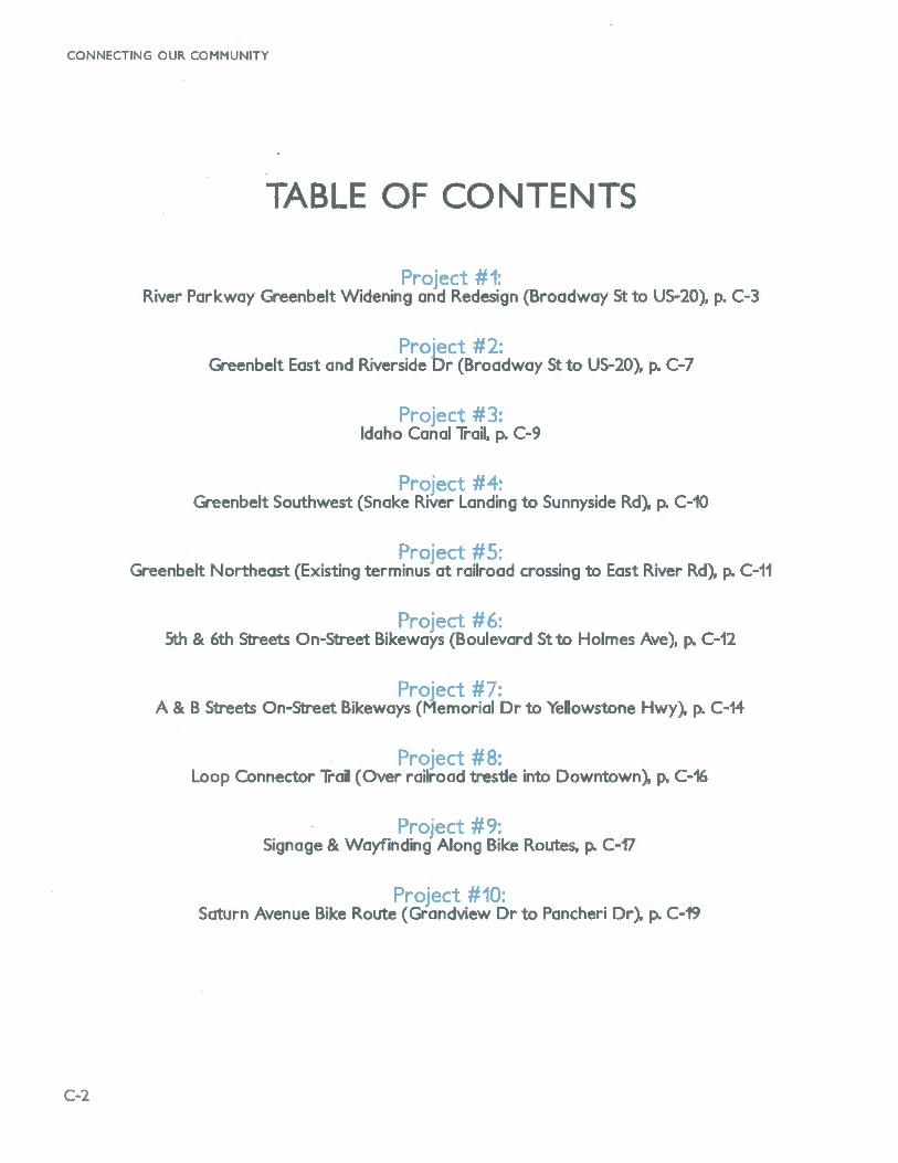
TABLE OF CONTENTS
River Parkway Greenbelt Widening and Redesign (Broadway St to US-20), p. C-3
p OJ .Ct 2. Greenbelt East and Riverside Dr (Broadway St to US-20), p. C-7
I C Idaho Canal Trail, p. C-9
p Greenbelt Southwest (Snake River Landing to Sunnyside Rd), p. C-10
Proj '/l 5· Greenbelt Northeast (Existing terminus at railroad crossing to East River Rd), p. C-11
D
5th & 6th Streets On-Street Bikeways (Boulevard St to Holmes Ave), p. C-12
? t -A & B Streets On-Street Bikeways (~emorial Dr to Yelowstone Hwy). p. C-14
··o
Loop Connector Trail (Over railroad trestle into Downtown), p. C-16
0 Signage & Wayfinding Along Bike Routes, p. C-17
ProJ t ""10. Saturn Avenue Bike Route (Grandview Dr to Pancheri Dr), p. C-19
C-2

r),...,.._
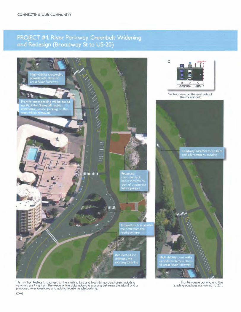
River Parkway is a two-way street between Broadway Street on the south and the Best Western Plus hotel on the north. North of the hotel, it becomes a oneway, northbound only street that leads to Landbank Street (an east-west street) and eventually dead ends at a vehicle turnaround, just south of the US-20 overpass and bridge overthe Snake River. This project will widen the Greenbelt trail to better accommodate existing high levels of non-motorized traffic, and adding amenities, additional vehicle parking, pedestrian connections to the hotels and services along River Parkway, and landscaping. This project will result in a continuous 14-16 foot wide greenbelt trail rather than the existing narrow 6' asphalt and concrete sections.
p This section of the Greenbelt trail is one of Idaho Falls' most popular recreational destinations. The existing trail in this section is a sidewalk that is approximately 6' wide. In order to accommodate the high volume of users and different user types (bicyclists, joggers, walkers, business and hotel patrons, children, and other visitors), the trail should be widened to 14' for most of the corridor, widening to 16' at the southern end near Broadway and at the bulb area and bus turn around. Landscaping improvements and crossings of River Parkway should be implemented at key crossing locations.
1r-r- -rr
Widening the trail will better accommodate the high-use and multiple usertypes along this section of trail. More space will help users maneuver, and avoid conflicts. Dedicated, high visibility crosswalks will provide crossings for hotel and business patrons and facilitate safe pedestrian movements.
,..
$692,300 in construction costs with a total project cost of $865,000 including engineering, mobilization and a 10% contingency.
APPENDIX C : PRIORITY PROJECTS
-.. . : • 3 ; . • , ''!It , ' I
This figure includes the southern port of the project near Broadway St Each figure after is the section north of the one previous.
C-3
CONNECTING OUR COMMUNITY
This section hghlights changes to the existing bus and truck turnaround area, including removed parking Tram the inside of the bulb, adding a crossing between the island ana a proposed river overlook, and adding front-in angle parking.
C-4
Front-in angle parking and the existing roadway narrowing to 22' .

APPENDIX C : PRIORITY PROJECTS
This section of River Pkwy is entirely one-way (northbound). Existing canal crossings allow hotel and restuarant patrons to access the Greenbelt Trail. Crossing improvements make these connections safer and more accessible. The existing 6' trail is widened to 14'. Landbonk Street is seen in the top left of the figure at right
C-5

CONNECTING OUR COMMUNITY
This is northernmost and final section of this project, terminating on the north at the tum around below the US-20 overpass.
C-6

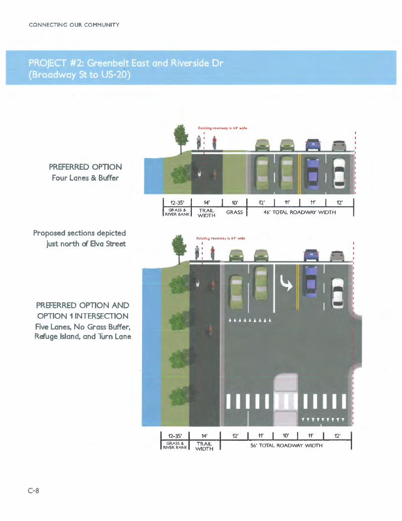
Riverside Drive is a 64 foot wide, five lane (four lanes plus a parking lane south of Gvitan Park) arterial that in 2010 carried 11,500 vehicles per day north of and under 10,000 south of Elva Street. The Snake River Greenbelt exists as a monolithic sidewalk for 1/3 mile along this stretch. There is little room to widen this trail to the 12 feet envisioned by the Greenbelt Renewal Plan without removing and replacing a significant number of mature trees, thus altering the view and the experience along the river. This project proposes three options to widen and improve this popular part of the Snake River Greenbelt.
Preferred Option: Through discussions with Idaho Falls Public Works, Planning and Parks the preferred option will be to maintain four travel lanes throughout the corridor, but provide a left turn lane only at Elva Street and across from the south parking lot of the Temple. This option will provide up to four additional feet of greenbelt width without reducing traffic capacity that could serve future growth.
Context map of the location of Priority Project #2.
APPENDIX C : PRIORITY PROJECTS
Pedestrian crossing improvements including refuge islands and flashing beacons will be added with any of the three options on the south side of the left turn pocket where the median space is not functional for vehicles.
Option A maintains four vehicle travel lanes and a center turn lane, but with slight reductions in lane width and a curb line relocation that provides up to seven additional feet of Greenbelt width.
Riverside Drive as it currently looks at the Bvo St intersection. The Snake River is on the right
Preferred Option/Option A Five lane intersection configuration. North of intersection, preferred option narrows to four lanes (adding a buffer
trailside) and Option A remains five lanes.
Option B: Five to three lane reduction narrows Riverside Drive and creates a 12 foot wide Greenbelt Trail and
vegetated buffer. This creates a parklike feel similar to the Greenbelt Trail on the west side of the river.
C-7
CONNECTING OUR COMMUNITY
PREFERRED OPTION
Four Lanes & Buffer
Proposed sections depicted
just north cl Elva Street
PREFERRED OPTION AND
OPTION 1 INTERSECTION
Five Lanes, No Grass Buffer, Refuge Island, and Turn Lane
C-8
Existing roadway is 6'4' wide
I
Existing roadway is 64' wide
14' TRAIL
WIDTH
12' 11' 10' 11'
56' TOTAL ROADWAY WIDTH

APPENDIX C : PRIORITY PROJECTS
Existing r-oodwoy is 6"4' wide
I
OPTION A Five Lanes
Proposed sections depicted just north of Elva Street
OPTION B Three Lanes
Option B attempts to reduce Riverside Drive to two vehicle travel lanes and a center turn lane. This configuration has been proven to handle as many as 20,000 vehicles per day in cities around the country and would be compatible with current traffic flows. Riverside Drive already narrows to one lane in both directions at the intersection with Memorial Drive. There is some question about the additional traffic increased development at and around Idaho State University north of Highway 20. Because of this Idaho Falls Public Works is concerned about limiting future capacity.
F -..---Any of the three options will allow increasing the width of the Greenbelt Trail by varying amounts. Option A, however, does so only minimally and the extra width
12' 12'
will be only enough to widen the trail itself - it will still be immediately adjacent to Riverside Drive. Option B reduces Riverside to three lanes of traffic so that the greenbelt area can be significantly enhanced and beautified similar to the transformation of Memorial Drive. The preferred option also provides additional greenbelt space, however at the two left turn lanes the trail will again return to a short monolithic configuration.
() -Option A and the Preferred Option, which slightly narrow the road, will cost approximately $785,000. The high cost reduction to three lanes (Option B) is approximately $1.1 million.
C-9

CONNECTING OUR COMMUNITY
O:'"- T The canals that cross Idaho Falls are an important part of the city's heritage and remain critical to agricultural operations throughout the region. The Idaho Canal Trail is envisioned to run from Iona Road to Tautphaus Park. Depending on future funding and local priorities, this trail could ultimately extend further to the north or south. This canal provides an important northsouth link though Idaho Falls, connecting many other potential trail corridors and on-street bikeways. It is one of the wider canals, it passes through a generous right-of-way, and is very scenic. It is currently operated and maintained by the Idaho Irrigation District. An agreement with the Idaho Irrigation District is needed prior to any trail development.
EFIT,.. The canal's proximity to a large amount of the Idaho Falls population, its transportation potential, and its general aesthetic appeal would result in a welcome benefit and amenity to the City and its residents. This route was noted multiple times during the public involvement process and it is currently being used by many residents in an unofficial capacity.
cos s Depending on the complexity of the project, the Idaho Canal Trail may cost between $1,520,000 and $1,805,000.
The Idaho C.Onol Trail would utilize the existing, unpaved mointoinence rood P.arollel to the canal. The above simulation depicts how the trail might look near E 14th St
C-10
This aerial plan view shows what the Idaho C.Onol Trail might look like at the crossing of E 12th St SW Bonneville Dr is the street thot parallels the trail to the west
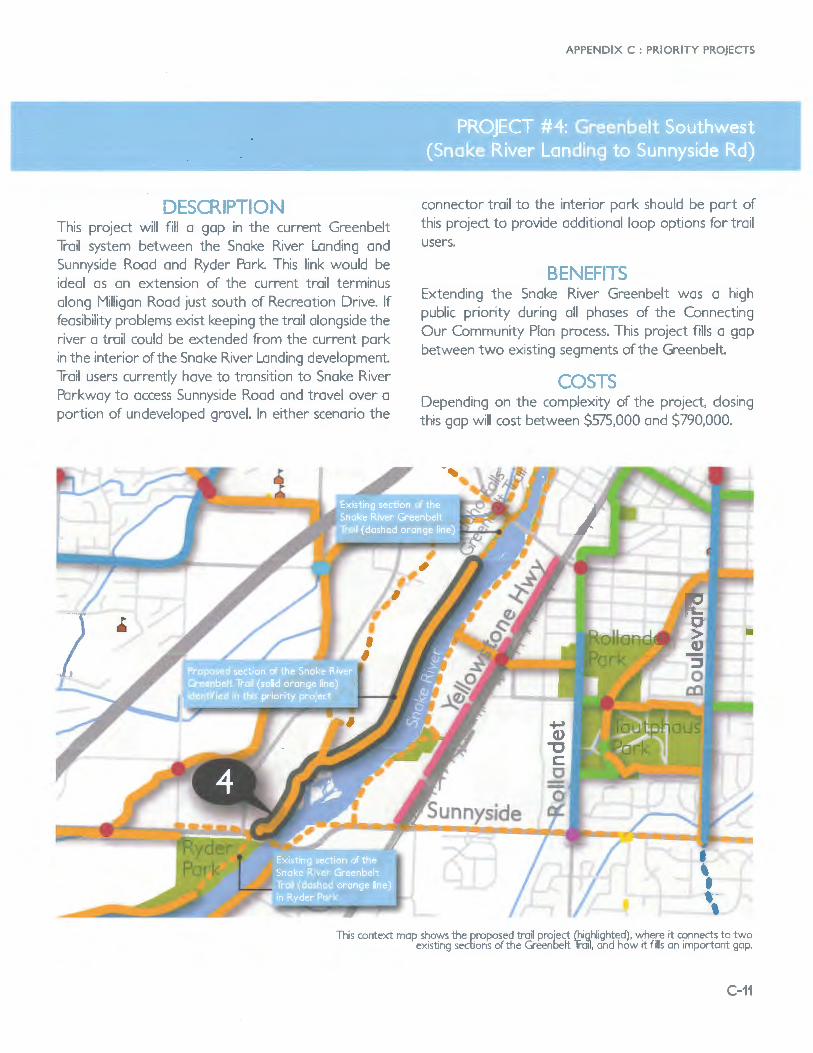
DE - -.-0 This project will fill a gap in the current Greenbelt Trail system between the Snake River Landing and Sunnyside Road and Ryder Park. This link would be ideal as an extension of the current trail terminus along Milligan Road just south of Recreation Drive. If feasibility problems exist keeping the trail alongside the river a trail could be extended from the current park in the interior of the Snake River Landing development. Trail users currently have to transition to Snake River Parkway to access Sunnyside Road and travel over a portion of undeveloped gravel. In either scenario the
APPENDIX C : PRIORITY PROJECTS
connector trail to the interior park should be part of this project to provide additional loop options for trail users.
BE ---5 Extending the Snake River Greenbelt was a high public priority during all phases of the Connecting Our Community Plan process. This project fills a gap between two existing segments of the Greenbelt.
'-"' Depending on the complexity of the project, closing this gap will cost between $575,000 and $790,000.
This context map shows the proposed trail project (highlighted), where it connects to two ex1st1ng sections of the Greenbelt Trail, and how it fills an important gap.
C-11

CONNECTING OUR COMMUNITY
L. Cl) .> -===I' a::
University
This context map shows the proposed trail project and how it connects to the current terminus of the Greenoelt Trail on the east side of the Snake River.
C-12
.... - :)
This project extends the Snake River Greenbelt north of the University of Idaho under the existing railroad bridge nearly two miles north to connect with the power plant If funding allows, it would be beneficial to extend the trail a further 0.65 miles to the east to connect with East River Road and subdivision residents along it. The Gty of Idaho Falls has already undertaken some planning in regard to this project. Easements through private property would also need to be secured. This project would also include a spur trail accessing University Boulevard.
E ........ TS This trail would not only extend the Idaho Falls Greenbelt to provide additional recreational benefits, but it could serve as an important transportation link for residents living along East River Road, connecting them not only to Downtown Idaho Falls and the rest of the Greenbelt system, but to the University of Idaho and the Idaho National Laboratory.
Depending on the complexity of the project, closing this gap will cost between $933,000 and $1,080,000.

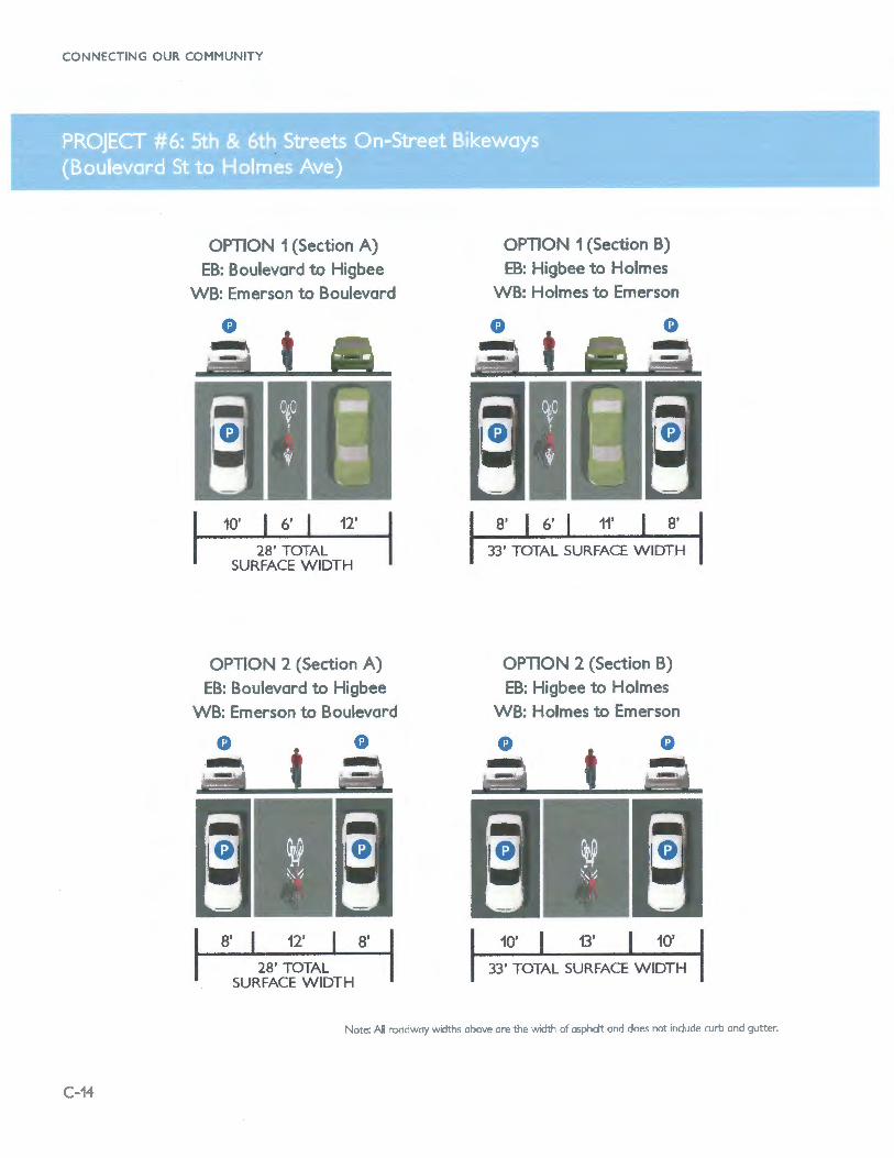
D ,.._ 5th and 6th Streets are a paired couplet of eastbound and westbound one-way residential streets, respectively, between Boulevard Street and Holmes Avenue that are 28 to 33 feet wide. The streets widen to 33 feet between Emerson and Holmes Avenues (WB) and Higbee and Holmes Avenues (EB). The first option to provide a designated route for bicyclists attempting to reach Downtown from points east involves removing parking on one side of the street to provide enough space for a bike lane (1a and 1b, next page). The second option (Option 2, Sections A and B) involves the placement of shared lane markings (with or without green paint underneath) in the center of the travel lane as an alternative to removing parking.
APPENDIX C : PRIORITY PROJECTS
,.. r-r -
These streets represent a key link in the bikeway network and build upon recommended bike lanes on Boulevard Street and Holmes Avenue. From the perspective of offering a consistent bike lane from Ammon all the way to Downtown Idaho Falls, Option 1 would offer benefits to bikeway users. Between Emerson (WB) or Higbee (EB) and Holmes Avenues, no parking loss is required due to the wider street. Option 2 would also provide connectivity into and out of Downtown. These streets are not busy enough that sharing a lane in these locations would be a significant barrier to bicyclists.
~c---
Bike lanes on 5th and 6th Streets (Option 1) will cost approximately $27,000. Shared· lane markings (Option 2) will be approximately $3,200.
This aerial mop shows the proposed bike lone or shored lone marking couplet project, how it connects to existing bike lanes and how it proVJdes a key connection to Downtown Idaho Falls.
C-13
CONNECTING OUR COMMUNITY
OPTION 1 (Section A) EB: Boulevard to Higbee
WB: Emerson to Boulevard
10' 6' 12'
28' TOTAL SURFACE WIDTH
OPTION 2 (Section A) EB: Boulevard to Higbee
WB: Emerson to Boulevard
8' 12'
28' TOTAL SURFACE WIDTH
8'
OPTION 1 (Section B) EB: Higbee to Holmes
WB: Holmes to Emerson
8' 6' 11' 8'
33' TOTAL SURFACE WIDTH
OPTION 2 (Section B) EB: Higbee to Holmes
WB: Holmes to Emerson
10' 13' 10'
33' TOTAL SURFACE WIDTH
Note: All roadway widths above are the width of asphalt and does not indude curb and gutter.
C-14

D r..... t Downtown Idaho Falls is characterized by narrow one-way streets with stop controlled intersections. A (westbound) and B (eastbound) Streets travel though downtown between the Greenbelt at existing marked crossings and Yellowstone Avenue. New Rectangular Rapid Flash Beacons (RRFBs) may be needed at both crossings of Memorial Drive to encourage driver yielding. B Street crosses Yellowstone Avenue at a signal and connects to an improved pedestrian crossing over the railroad tracks. Several options are possible along these streets.
Option 1 involves placing shared lane markings in the center of the single travel lane; a green band, which has been shown to increase bicyclist confidence and driver awareness of and courtesy to bicyclists, may be added to this arrangement similar to treatments in
and
Option 2 involves creating a two-way protected bikeway on the south side of B Street linking the RR crossing with the Greenbelt. This would involve the removal of 40 diagonal parking spaces and one parallel parking space on the south side and potentially reworking some of the curb extensions.
Option 3 could involve creating a car-free pedestrian mall where bicycles would be allowed to circulate slowly. Wellmarked and/or raised crossings at crossstreets would be needed. This option might also provide additional vitality and event space to Downtown.
OPTION 1 Green Shared Lanes on
A and B Streets
16' 14'
38' TOTAL SURFACE WIDTH
APPENDIX C : PRIORITY PROJECTS
I"'" I"'"['"..,..,..
Providing a visible improvement to bicycling in and through downtown will encourage visitors and residents to access downtown by bicycle. This will result in increasing the number of people in the core of downtown without needing to increase parking supply. Some businesses, such as restaurants and cafes, will see direct benefits to patronage by increasing the convenience of some patrons.
Shared lane markings (Option 1) will be approximately $1,900. A two-way cycle track on B Street (Option 2) will cost approximately $58,900.
8'
Context map of the location of Priority Project # 7.
This photo simulates what B Street would look like with a _green shared lane in the existing travel lane width (Option 1).
C-15

CONNECTING OUR COMMUNITY
12'
OPTION 2 Two-way Protected Bikeway on B Street
4' 12' 10'
38' TOTAL SURFACE WIDTH
G
C-16
OPTION 3 Pedestrianizing B Street
These examples show how other cities (the first two with sizes similar to Idaho FaOs) have converted streets into into car-free
pedestrian malls. Top to bottom: Charlottesville, NC; Salem, Massachusetts; and Washington, D.C.

.,... N
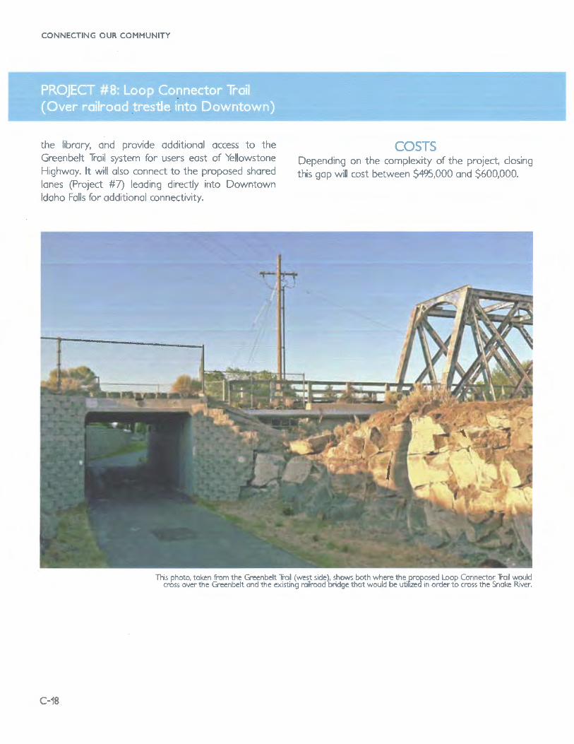
Sportsman Park is a popular destination for residents and visitors alike with its unique blend of views and setting including the Japanese Friendship Gardens. Two pedestrian bridges currently link the 'island' to both sides of the Snake River and the Greenbelt Trail. The first is a wide, historic replica of the first bridge over the Snake River in Idaho Falls and serves pedestrians and bicyclists well. The second, which connects to the east bank of the river, is very narrow and is not comfortable for bicyclists to use. There is barely enough room for pedestrians to pass each other mid-
APPENDIX C : PRIORITY PROJECTS
span. An unused, historic railroad bridge also bisects Sportsman Park. This project involves extending the current trail north along the Sidehill Canal south of Sportsman Park, retrofitting the railroad bridge for bicycle and pedestrian use, and establishing a trail in the former rail bed along the back side of the City library to Yellowstone Highway.
t- s This project would provide another loop trail connecting to Downtown Idaho Falls, improve access to Sportsman Park. improve the Greenbelt Trail behind
This aerial mop shows the proposed loop Connector Trail, how it connects to the existing_ Greenbelt Trail, and how it provides a key connection to Downtown Idaho Falls across the River.
C-17
CONNECTING OUR COMMUNITY
the library, and provide additional access to the Greenbelt Trail system for users east of Yellowstone Highway. It will also connect to the proposed shared lanes (Project #7) leading directly into Downtown Idaho Falls for additional connectivity.
c-,....,..::,
Depending on the complexity of the project, closing this gap will cost between $495,000 and $600,000.
This photo, token from the Greenbelt Trail (west side), shows both where the proposed Loop Connector Trail would cross over the Greenbelt and the existing railroad bridge that would be utiflzed in order to cross the Snoke River.
C-18

[) ... ,._ Tl-Many of the on-street bikeway recommendations presented in the Connecting Our Community Plan are designed as 'signed bicycle routes'. Most of these are recommended along local streets with low vehicle volumes and speeds, making them comfortable for a variety of bicyclists. All signed bicycle routes should include bicycle route wayfinding signage; it is recommended that as many as possible also be outfitted with shared lane markings. Shared lane markings have been effectively shown to promote safer riding behavior, greater respect from drivers to bicyclists, and improved wayfinding for routes (especially those away from familiar collector roadways).
0 I FITS
Marked bicycle routes are inexpensive to implement and could be completed in batches or in total. Quickly
Woyfinding shored lone markings, Jackson Hole, WY.
APPENDIX C : PRIORITY PROJECTS
completing these facility types would rapidly grow the on-street bicycle network in Idaho Falls and provide a high value as an initial project type. Future bicycle lanes and shared-use path projects would also connect to and enhance the value of these on-street bikeways.
C;) ..... 5 Shared lane markings and signage cost approximately $12,000/mile.
Woyfinding signs, Jackson Hole, WY.
C-19

CONNECTING OUR COMMUNITY
Project
25th St
Saturn Avenue
5th & 6th Couplet
June Ave
A & B Streets
Brentwood
Castlerock Lane
Wabash St
12th St
Bannock/Sage
Elva Street
Park & Shoup Avenues
G Street
Rollandet St
Eastem Ave/Curtis Ave/Rollandet
Tautphaus Park Connector
Calkins Ave/Park Dr
Ridge Ave I Poplar St
Nixon Ave
Jennie Lee/Craig/Bengal
Maple/Cliff St
Emerson St/14th St
W Riverview Drive
East-West Ammon
East-West Ammon #2
Midway
Canal trail to Bike Route Connector
Upland Street
Ammon Bike Route Connector
Derrald Ave/Owen Street/High School
Princess Dr
Georgia Ln
North-South Ammon
Forest Glen
North-South Ammon #2
C-20
From To
Idaho Falt
Blvd St Holmes Ave
Pancheri Dr Grandview Dr
Blvd St Holmes Ave
17th St John Adams Pkwy
Memorial Dr Eastern Ave/YeHowstone Ave
Troy Ave Skyline Dr
Stonebrook Ln Holmes Ave
John Adams Pkwy Elva St
Blvd St Hope Lutheran Church & School
Memorial Dr Anderson St
Holmes Ave Proposed Idaho Canal Trail
Cliff St G St
Memorial Dr Shoup Ave
21st St Pancheri Dr
17th St Birch St
Rollandet St Sunken Diamond Dr
RollandetSt Proposed Butte Arm Canal Pathway
Eastern Ave Blvd St
12th St Gallup St
25th St 17th St
Boulevard St Proposed Loop Connector
Proposed Butte Arm Canal Pathway Holmes Ave
Bonnevlle Countv Greenbelt Trail East E River Rd
Ammon
Ammon City Path Bridge McCowin Park
Salmon St Belle Arbor Dr
Sunnyside Rd john Adams Pkwy
Sandcreek Middle School Connector Midway Ave
Ammon Rd Stevens Dr
Rawson St Targhee St
25th St Ammon Rd
Wanda St Sunnyside Rd
Ammon Rd Ross Ave
Sunnyside Rd Lincoln Rd
Princess Dr 45th E
Ross Ave Lincoln Rd
This table lists all recommended projects in this plan that fall under the category that indudes bike routes with wayfinding signage and pavement markings,
induding those that have an option for this type of facili1y.
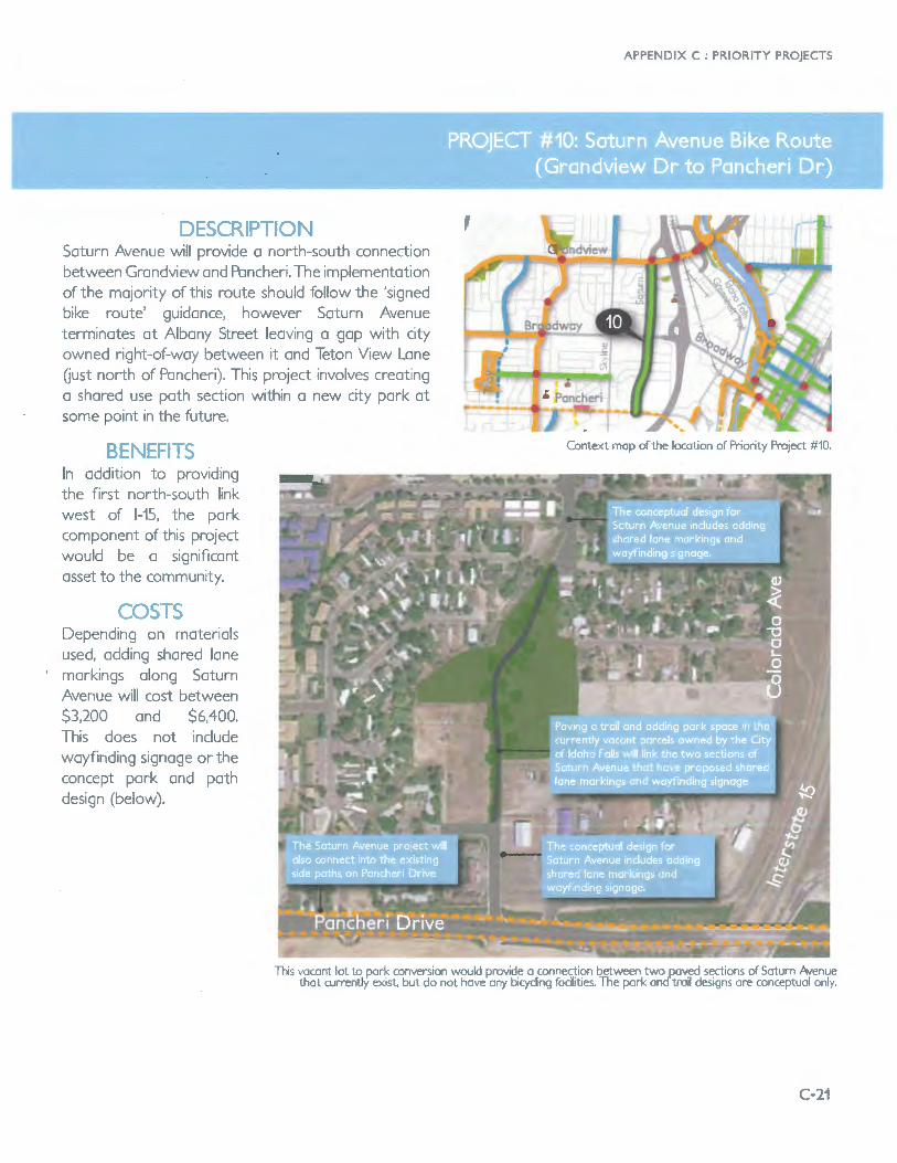
D - -re Saturn Avenue will provide a north-south connection between Grandview and Pancheri. The implementation of the majority of this route should follow the 'signed bike route' guidance, however Saturn Avenue terminates at Albany Street leaving a gap with city owned right-of-way between it and Teton View Lane Oust north of Pancheri). This project involves creating a shared use path section within a new city park at some point in the future.
r""l"T"
In addition to providing the first north-south link west of 1-15, the park component of this project would be a significant asset to the community.
~
Depending on materials used, adding shared lane
' markings along Saturn Avenue will cost between $3,200 and $6,400. This does not include wayfinding signage or the concept park and path design (below).
APPENDIX C : PRIORITY PROJECTS
Context mop of the location of Priority Project #10.
This vacant lot to pork conversion would provide a connection between two paved sections of Saturn Avenue that current.JY exist, but do not hove any bicycling facilities. The pork and troil designs ore conceptual only.
C-21


