66
Conservation Area Appraisals in the Yorkshire Dales National Park Downholme Adopted document

Conservation Area Appraisals in the Yorkshire Dales National Park
Downholme Adopted document

2
Table of Contents
PART I
1.0 Introduction 4 1.1 The Area 4 1.2 The Appraisal 4 1.3 Summary 6
2.0 Planning Policy Framework 7 2.1 What Is a Conservation Area? 7 2.2 Benefits of Designation 8
3.0 Special Interest 10 3.1 General 10 3.2 Summary of the Special Interest Downholme 10 3.3 Summary of Issues Threatening the Special Interest of
Downholme 11
4.0 Assessing Special Interest 12 4.1 Location and Setting 12
a) Location and Context 12 b) General Character and Plan Form 13 c) Landscape and Setting 14
4.2 Historic Development and Archaeology 16 a) Origins and Historic Development of the Area 16 b) Archaeology 18
4.3 Spatial Analysis 19 a) Character and Interrelationship of Spaces within the Area 19 b) Key Views and Vistas 22
4.4 Character Analysis 29 a) Definition of Character Zones 29 b) Activities and Former Uses and Their Influence on Plan
Form and Buildings 32 c) Quality of Buildings and Their Contribution to the Area 34 d) Traditional Building Materials, Local Details and the Public
Realm 42 e) Contribution Made to the Character of the Area by Green
Spaces and Its Biodiversity Value 45 f) Value Attributed by the Local Community and Other
Stakeholders 49 g) General Condition of Downholme 49
5.0 Boundary Changes 52
6.0 Community Involvement 53
7.0 Useful Information, Appendices and Contact Details 55 7.1 References and Further Reading 55 7.2 Glossary of Terms and Abbreviations 57 7.3 Contacts 59 7.4 Maps of Downholme 59
PART II
8.0 Management Proposals 63

3
List of Figures
Figure 01: Location map 12 Figure 02: Built environment 14 Figure 03: Landscape features 15 Figure 04: Quarry 15 Figure 05: How Hill 16 Figure 06: Later historic development 17 Figure 07: Archaeological features 18 Figure 08: Definition of space 20 Figure 09: Space 1 21 Figure 10: Space 2 21 Figure 11: Space 3 22 Figure 12: Space 4 22 Figure 13: Key views 23 Figure 14: View 1 23 Figure 15: View 2 24 Figure 16: View 3 24 Figure 17: Views 4a-d 25 Figure 18: View 5 26 Figure 19: View 6 26 Figure 20: View 7 26 Figure 21: Views 8 27 Figure 22: View 9a & b 27 Figure 23: View 10 28 Figure 24: View 11 28 Figure 25: View 12 28 Figure 26: View 13 29 Figure 27: View 14 29 Figure 28: Character zones 30 Figure 29: Bolton Arms 32 Figure 30: Past and present uses 33 Figure 31: Timber framed shed 35 Figure 32: Church of St Michael & All Angels 36 Figure 33: Coffin south of chancel door 36 Figure 34: Cross south of church 37 Figure 35: Downholme Hall ruins 37 Figure 36: Home Farmhouse 38 Figure 37: The Vicarage 38 Figure 38: Former smithy between Nos. 5 & 6 39 Figure 39: No. 10 and curtilage outbuilding to southwest 40 Figure 40: Manor House 41 Figure 41: Former school with outbuildings 41 Figure 42: Lime kiln at Downholme Quarry 41 Figure 43: Local details and public realm 43 Figure 44: Features of local interest 44 Figure 45: Features in the public realm 44 Figure 46: Front garden at North House 45 Figure 47: Trees and hedges 45 Figure 48: Millennium Woodland 46 Figure 49: Field mosaic with trees 47 Figure 50: Yew trees and holly in churchyard 47 Figure 51: Mature/veteran tree in field to south of church 48 Figure 52: Poplar trees lining approach to Manor Farm 48 Figure 53: Negative factors 50 Figure 54: Downholme Conservation Area as designated in 1995 60 Figure 55: Proposed extended Downholme Conservation Area 61 Figure 56: Mid-C19 map 62 Figure 57: Late-C19 map 62

4
1.0 Introduction
The historic environment provides a tangible link with our past and contributes to our sense of national, local and community identity. It also provides the character and
distinctiveness that is so important to a positive sense of place. […] The historic environment is a unique, fragile and non-renewable resource which contributes to the economy,
society and daily life. Once lost, it cannot be replaced 1.
This document provides a detailed appraisal of Downholme, which lies partly inside the Yorkshire Dales National Park, with the area to the south of the main street being outside its boundary and therefore the responsibility of Richmondshire District Council (RDC). The village and its immediate setting outside the National Park were designated as a conservation area in December 1995 (Figure 54). In 2016, Hudswell & District Parish Council approached the Yorkshire Dales National Park Authority (YDNPA) with the request to also designate parts of Downholme inside the National Park, as well as to review the existing conservation area boundary. It has been agreed with the District Council that YDNPA would take the lead on writing the appraisal.
There is no adopted appraisal for the existing conservation area, but a brief report on the potential of the whole village as a conservation area was written by Michael Lamb as part of An Appraisal of Settlements in the Yorkshire Dales National Park in 1991.
Although this appraisal tries to cover the main aspects of the conservation area, it cannot be completely comprehensive; omission of particular buildings, features or spaces should not be taken to imply that they are of no interest.
1.1 The Area
Downholme is currently one of 41 conservation areas that are the responsibility of Richmondshire District Council. The proposal to designate parts of the village and its immediate surroundings which are inside the National Park would make it the 47th conservation area within the newly extended Yorkshire Dales National Park. A proposed total area of 27.71 hectares – of which 7.84 hectares are already designated outside the National Park – would encompass the entire village and its immediate surroundings, as well as the more isolated church and Vicarage (see 5.0 & Figure 55).
The overall character of the village is informal and in parts dispersed as a result of its historic development, and rural due to its vernacular architecture and the continued farming practice within the area. In addition, the remainders of its former industrial character (mining and quarrying) still survive in various locations. Downholme is an attractive village that is located within a beautiful landscape setting (see 4.1.b). It is generally in good condition (see 4.4.g).
1.2 The Appraisal
Purpose. Every conservation area has a distinctive character which has been shaped over time by its natural and man-made surroundings. This appraisal provides justification for extending the Downholme Conserva-tion Area, by evaluating and recording the special interest of the village (see 3.0-4.0). It will set out how the place has evolved, draw out the key
PART I CHARACTER APPRAISAL
1 DCLG et al. 2010, paragraphs 5, 6 & 8.

5
elements of its character and quality as it is now, and define what is positive and negative, and opportunities for beneficial change. However, neither the designation nor appraisal should be seen as an end in itself, but as a step towards the preservation and enhancement of Downholme’s character and appearance, providing a basis for making sustainable decisions about its future. Conservation areas can be susceptible to incremental and dramatic change due to neglect caused by economic decline, as well as over-investment and pressure for development. Hence the appraisal aims to counteract threats which would alter what made the area attractive and unique in the first place, and to help promote positive change.
The appraisal provides information about Downholme for residents, the wider public and other stakeholders. Nevertheless, it is always advisable to contact the local planning authority before undertaking any work on or within the vicinity of designated heritage assets, including conservation areas.
Scope. This document is divided into two parts:
Part I: The character appraisal highlights what is architecturally and historically important about Downholme, identifies any problems within it, and proposes an extended conservation area boundary
Part II: The management plan contains proposals for preserving and/or enhancing the character of Downholme
A draft version of this document was available for public consultation from 29 September to 10 November 2017 (see 5.0); it was based on the findings of various site visits undertaken by YDNPA and RDC staff between February 2016 and April 2017 and sources from the YDNPA’s Historic Environment Record, which included historic OS maps, aerial photographs, survey reports and bibliographic records; literature and websites that have been consulted are listed at the back (see 7.1). The comments received during the consultation period were then reviewed and the draft updated in the light of them. The amended appraisal was put forward for members’ approval at the YDNPA’s meeting on 27 March 2018, and at RDC on 04 April 2018. The Downholme Conservation Area Appraisal was finally adopted on 27 March 2018.

6
1.3 Summary
The Downholme Conservation Area at a Glance:
Date of designation: December 1995 see 1.1
Location: SE 113 979, outside National Park see 4.1.a
Current size: 7.84ha see 1.1
Changes to boundary: Yes see 5.0
Proposed size: 27.71ha see 1.1
Boundaries: See maps see 7.4
General character: Rural, informal, in parts dispersed village see 4.1.b
Special interest: Fine landscape setting at foot of How Hill see 4.1.c Medieval plan form & development of place see 4.2.b Former uses and MoD ownership see 4.4.d/f Vernacular buildings; medieval remains see 4.4.c 1950s village signs & other features see 4.4.d
General condition: good see 4.4.g
Scheduled monuments: None see 4.2.b
Listed buildings: 6, of which 1 outside National Park see 4.4.c
Listed buildings ‘at risk’: None, but 1 ‘vulnerable’ see 4.4.c
Negative factors: Electricity/telegraph poles, hardstanding, modern materials/development, damage to walling & gates, signage, metal fence around reservoir see 4.4.g

7
2.0 Planning Policy Framework
The YDNP Authority’s policies for heritage assets, including conservation areas, along with other related policies concerning the development and use of land, are set out in the Yorkshire Dales National Park Local Plan 2015-30. The policies contained within chapter ‘5 Cultural Landscape’ are particularly relevant:
L1 – Heritage assets: To ensure development proposals conserve and, wherever possible, enhance the heritage assets of the National Park.
L2 & L3 – Conversion of traditional buildings – acceptable uses & building treatment: To allow traditional buildings to be put to alternative uses where the building and its location is able to accommodate the intensity of the new use and associated impacts, and to ensure re-use proposals do not undermine the architectural and historic character of the building and its landscape setting, or result in other harmful impacts.
L4 – Demolition and alteration of traditional farm buildings: To support the alteration of traditional farm buildings where it would prolong their beneficial use and, as a last resort, the demolition of some buildings where it would not harm the Special Qualities of the National Park.
L5 – Heritage assets – enabling development: To conserve significant heritage assets by permitting departures from normal planning policy in circumstances where the heritage benefits will outweigh the policy disbenefits.
There are further relevant policies in ‘Chapter 4: Community’, in particular:
C13 – Important open space: To retain the contribution that important open spaces make to amenity, recreation and the historical character of towns and villages.
The YDNPA Local Plan is in compliance with national legislation, policy and guidance which include the National Planning Policy Framework (NPPF) and Historic England’s Good Practice Advice Notes 1 – 3. All national legislation, policy and guidance are material to individual planning and heritage consent decisions.
For the area outside the National Park, the Richmondshire Local Plan 2012-2028 applies. ‘Core Policy CP12: Conserving and Enhancing Environmental and Historic Assets’ is particularly relevant.
2.1 What Is a Conservation Area?
Section 69(1)(a) of the Planning (Listed Buildings and Conservation Areas) Act 1990 defines a conservation area as:
an area of special architectural or historic interest the character or appearance of which it is desirable to preserve
or enhance
Please note that the conservation area boundary is not the same as any development or housing boundary identified in the Local Plan and has a different function, although in places they may coincide.

8
Designation. It is the duty of the local planning authority to designate conservation areas 1, preferably with input from the local community. When considering designation, local planning authorities should ensure that an area justifies such status because of its special architectural or historic interest, and that the concept of conservation is not devalued through the designation of areas that lack special interest 2. The quality and interest of the overall built historic environment rather than of individual buildings should be the prime consideration. The courts have held it legitimate to include the setting of buildings that form the heart of an area within the conservation area boundary 3.
Review. It is also the duty of the local planning authority to regularly review its conservation areas and, where appropriate, designate new parts 4. Likewise, if the original interest is so eroded by subsequent changes that it is no longer special, boundary revisions or cancellation should be considered.
Performance. Further duties of the local planning authority comprise, in consultation with the public, formulating and publishing proposals for the preservation and enhancement of conservation areas 5. It will also seriously consider the desirability of preserving or enhancing their character or appearance when exercising planning powers 6. National Park family indicators provide a tool to monitor the National Park Authority’s performance regarding these functions.
Implications. Conservation area designation may result in resource implications for owners, developers and residents because of the increased statutory controls and particular requirements for the repair and alteration of existing, or the construction of new, buildings. Although restrictions on permitted development rights (i.e. minor works that do not require planning permission) are only very limited inside the National Park, Article 4 directions have the power to withdraw them (see 2.2).
2.2 Benefits of Designation
Conservation area status offers advantages to both the public and the local planning authority.
The public. Conservation areas can enhance economic well-being and quality of life, as well as offer a certain amount of continuity and stability in a rapidly changing world. At the same time, conservation-led change can make a positive contribution enabling communities to regenerate. Appraisals should help guide the form and content of development, enhancement of the public realm, traffic management and outdoor advertisement. The value of an area is beneficial to both owners and developers, and estate agents are likely to put increasing emphasis on such a location when advertising properties.
Conservation area appraisals are intended to be informative and educational documents about our cultural inheritance and to raise public awareness and support upon which the prosperity of an area is sustained. They will assist if funding is sought for grant-aid and financial assistance for owners to encourage repairs and preventative maintenance.
The local planning authority. Designation helps us to manage change by applying robust conservation policies to an area.
Decision-making – In exercising any planning functions affecting land or buildings within a conservation area, the local planning authority has a general duty 7 to pay special attention to the desirability of preserving or enhancing the character and appearance of that area. Planning functions
1 Planning (Listed Buildings and Conservation Areas) Act 1990, section 69(1)(b).
2 Department for Communities and Local Government 2012, para 127
3 Historic England 2015c, 2 4 Planning (Listed Buildings
and Conservation Areas) Act 1990, section 69(2).
5 Planning (Listed Buildings and Conservation Areas) Act 1990, section 71.
6 ibid, section 72. 7 ibid, section 72. This duty
also applies to the Planning Inspectorate when determining planning appeals or conducting examinations into the soundness of development plans.

9
include both the formulation of planning policies and the determination of planning applications. Although conservation area designations and character appraisals help to inform planning decisions, they alone do not determine whether development will or will not be acceptable. The impact of development upon the special architectural and historic interest of a conservation area needs to be weighed against other planning considerations in reaching a decision. In the National Park, the Local Plan forms the basis for most planning decisions and its policies allow a variety of development types within conservation areas.
Planning control – Designation automatically brings additional safeguards, such as the need for planning permission when demolishing unlisted buildings and walls 8 or lopping and felling trees 9. Within the National Park conservation area status only has a very limited effect on ‘permitted development’. This is because the National Park designation already restricts permitted development rights 10.
Article 4 of the Town and Country Planning (General Permitted Development) Order 2015 enables local planning authorities to further withdraw permitted development rights. This would be justified where there is firm evidence to suggest that permitted development which could damage the character or appearance of a conservation area is taking place or is likely to take place, and which should therefore be brought into full planning control in the public interest 11. In the Yorkshire Dales National Park there are currently only two conservation areas which have Article 4 directions: the Settle-Carlisle Railway on the erection of telecommunication masts and Castle Bolton in relation to agricultural permitted development rights.
Management plans – Neither the designation of a conservation area or the preparation of a character appraisal is an end in itself. The local planning authority is also required, in consultation with the public, to formulate management plans to help preserve and enhance those areas 12. Conservation-area-specific plans may set out a variety of measures designed to help safeguard, manage and improve the area within its historic context; draft management proposals for Downholme are set out in Part II of this document. Furthermore, the overarching Yorkshire Dales National Park Management Plan 2013-18 includes objectives (A2 and A4) for targeting conservation areas ‘at risk’.
8 Planning (Listed Buildings and Conservation Areas) Act 1990, section 74(1).
9 Town and Country Planning Act 1990, section 211(3).
10 Town and Country Planning (General Permitted Development) Order 2015, schedule 2 part 1.
11 ibid, Article 4. 12 Planning (Listed Buildings
and Conservation Areas) Act 1990, section 71.

10
3.0 Special Interest
The purpose of this appraisal is to define the special interest of Downholme that warrants conservation area designation, as summarised below. A detailed analysis is provided in the next chapter (see 4.0).
3.1 General
The special architectural or historic interest of a conservation area is reflected in its character or appearance which it is
desirable to preserve or enhance.
When defining the special interest of Downholme, its significance and distinctiveness are judged alongside local and regional criteria, whilst also recognising values attributed to the area by the local community and all those with an interest in it 1. The more clearly special interest is defined, the sounder will be the basis for local policies, development control decisions and management proposals. This helps reduce the potential uncertainty for owners and others when investment or development in the area is considered 2.
The significance of a place embraces all cultural and natural heritage values. These are 3:
Evidential value: the physical remains of past human activity. In the absence of written records, the material record provides the only evidence about the distant past.
Historical value: the ways in which past people, events and aspects of life can be connected through a place to the present.
Aesthetic value: the sensory and intellectual stimulation people draw from a place. It can be the result of the design of a place or its (often seemingly organic) development over time.
Communal value: the meanings of a place for the people who relate to it.
3.2 Summary of the Special Interest of Downholme
The special character of Downholme lies in the following; please note that the assessment has gone beyond the boundary line as designated in December 1995:
Evidential value: small Dales village with majority of buildings built along main street in local vernacular style and dating from the mid-19th century or earlier (see 4.1.b); shape/layout of village has generally been retained since at least the mid-19th century, with remains of former medieval land use still evident, and the former 20th-century MoD ownership of the village is also evident in various features and the relative lack of recent development (see 4.2.b); noteworthy (listed) buildings are the isolated church of St Michael & All Angels which has 12th-century origins, the remains of the medieval Downholme Hall, the 17th-century Home Farmhouse, and the later-19th-century Vicarage to the west of the main settlement including polite architectural elements (4.4.c);
1 Historic England 2016a, 13. 2 ibid, 5. 3 English Heritage 2008, 21 &
28-32.

11
other noteworthy features within the public realm are the three 1950s village signs with reflective studs (see 4.4.d)
Historical value: development of settlement of possibly pre-Conquest origins as an agricultural village derived from a medieval planned layout, with crofts and tofts built around a central village green, and the impact of the lead mining industry and resulting population growth from the 18th to mid-19th centuries on the current layout of the village (see 4.2.a + 4.4.b)
Aesthetic value: numerous attractive external and internal views, both from within the conservation area and when viewing from the road on Downholme Moor, and a variety of well-related spaces within the village; small stone-built agricultural outbuildings may form focal points in key views (see 4.3)
Communal value: fine landscape setting at the foot of How Hill (see 4.1.c + 4.3.b); attractive vernacular historic environment draws walkers and other visitors into the conservation area, and provides a desirable place to live for permanent residents. The village also has close ties to the use of the nearby MoD military training area (see 4.4.f)
3.3 Summary of Issues Threatening the Special Interest of Downholme
The main detractors, problems and pressures threatening the special interest of Downholme are listed below; again, please note that the assessment has gone beyond the boundary line as designated in 1995. Further details will be discussed later (see 4.4.g).
Electricity/telegraph poles throughout the area Areas of hardstanding encroaching onto formerly grassed
areas Replacement of traditional roof slates Unsympathetic modern additions to traditionally built
houses or new structures in their curtilage Collapse and instability of sections of drystone boundary
walling Unnecessary amount of signage at main junction Deteriorating timber gates and signage within the public
realm Prominent metal fence surrounding covered reservoir and
brightly coloured barrier across the track Non-traditional windows Sewage works
Some of these issues could be addressed through statutory action by the Authority. For example, Article 4 directions can provide better control on alterations within the conservation area (see 2.2).
Proposals for the management of Downholme are outlined in Part II.

1
F
bc2
2
Figure 01: L1:50,000, witboundary in copyright an2017 Ordnan100023740)
Location mapth National Pyellow (© Crd database rnce Survey
p @ Park rown rights
4.0 As
This chapteDownholmeand archaeinterest hasassessmendesignated
4.1 Loc
This sectionplan form, a
a) Locatio
The villageNorth YorksYorkshire D979, which Richmond, Leyburn thrsettlement. Hudswell tovillage is lo
Detailed ma
This small vlocation for which has bother facilitiMarske (whwalking arepoint (see 4the ownerssignificant amore recen
N
ssessin
er comprisese with regardeology, spatias already beent in this chd in Decemb
cation an
n describes tand landscap
on and Conte
of Downholmshire, and is Dales Nation
is about 6.5outside the
rough Downh There is, ho
o Downholmecated, close
aps of Down
village seemr walkers andbeen in use sies. As Downhich is about ea and scene4.4.f). From thip of the Miamounts of sntly been sold
YorkDa
NatPa
ng Spec
s a detailed ad to its locatioal issues, anen provided
hapter goes ber 1995.
nd Settin
the location ape setting of
ext
me lies withinlocated on tal Park. Thekm to the sonational parkholme, althouowever, anote, and it is alto its junctio
nholme can b
ms to be a wed has a publisince the 19t
nholme lies j2.5km to the
ery, some touthe 1930s, thnistry of Def
surrounding ld into private
kshire ales ional ark
cial Inte
analysis of thon and settind character. (see 3.2). Plbeyond the
g
and context, Downholme
n the parish he extreme nnational griduthwest of thk. The A6108ugh it by-pasher ‘tank roalong this rout
on with the A6
be found in th
ll-visited desc house, theth century. Thust off the coe north) and urists use thehe village wafence (MoD),and, althoug
e ownership (
erest
e special intng, historic dA summary
lease note te boundary l
general chae.
of the same north-easternd reference ihe historic m8 leads from sses the maiad’ from Richte where mo
A6018.
he appendix
stination as ite Bolton Armshere are no soast-to-coasis within an
e village as aas gradually , which still ogh the buildin(see 4.2.a).
erest of evelopment of the speciahat the ine as
aracter and
name, in n edge of thes SE 113
market town oRichmond ton part of the
hmond via ost of the
(see 7.4).
t is in a goods (Figure 29shops or t walk at excellent a stopping brought into
owns ngs have
al
e
of o
d 9),

13
In the Yorkshire Dales National Park Local Plan 2015-30 as well as in the Richmondshire Local Plan 2012-2028, Downholme has not been identified as a service village, as it does not meet the criteria. As such, specific provision has not been made under either of these development plans for erection of new houses within the village.
b) General Character and Plan Form
General character. The rural nature of Downholme is the result of the vernacular architecture of the village and outlying buildings, and the dry-stone walled pastures of the surrounding farm land, now mainly grazed by sheep. Evidence of former small-scale mining and quarrying sites provide additional interest in some locations. The wider landscape setting of the settlement is very attractive, with views onto How Hill and towards Swaledale (see 4.1.c & 4.3.b).
Most buildings in the area are now in residential use, with the exception of the pub, the church and some agricultural buildings (see 4.4.b). The majority of surviving houses in the village were built between the late 18th and mid 19th centuries, and generally originated as three-bay two-storey buildings, some of which were later subdivided or extended (see 4.4.c). The construction materials used throughout Downholme make a significant contribution towards its character. These mainly comprise local stone for walls and roofs, which provide muted natural colours and textures in keeping with its surroundings, although modern and untypical materials have also been introduced since the MoD ownership of the village. Front gardens are generally small or non-existent, but many properties have larger back gardens enclosed by drystone boundary walls. There are frequent small green spaces throughout the village, taking the form of grassed verges alongside the road (see 4.4.d) and open areas, some derived from the historic village greens (see 4.2.a). Frequent clusters of trees are found throughout the area, often situated along boundary walls and roadsides, but there are also some impressive individual trees within the fields to the north of the village (see 4.4.e).
There are limited opportunities for car parking within the settlement, due to its small size, and as houses tend to face directly onto the road. The main street through Downholme has no pavements and is wide enough in the centre to accommodate a small amount of roadside parking, and is usually not congested with traffic. There are two car parks, one for customers of the Bolton Arms public house (Figure 10), and another one nearby for use by residents.
Plan form. The properties in Downholme are arranged in a fairly dispersed manner. Whilst the buildings inside the village are aligned along the ‘tank road’ (via Hudswell) to Richmond rising east towards the open moor – from now on referred to as the main street – and the two cul-de-sacs, a few buildings are more isolated from the main part of the settlement; these include the Vicarage at the road junction to the west, the isolated church to the north, the Manor House Farm complex to the south, and a few large modern agricultural buildings to the southwest.
Inside the village, its core comprises a number of properties flanking the main street in an informal manner, indicating that the place grew organically over time. The densest concentration of houses is in the centre of the village, where rows of properties face each other across the street, interspersed with a smaller number of agricultural or former agricultural buildings (Figure 17). The two short cul-de-sacs branch off the main street: the one to the north leading past a few smaller outbuildings to North House (Figure 19), and the one to the south leading past a few houses towards Manor House Farm, which is in an elevated position (Figure 18).

14
Figure 02: Bmap regress(graphics © YDNPA, 201
Built-environsion @ 1:5,0Gaby Rose,
17)
ment 00
c) Landsc
The fine lanattracting whigh-qualityof Downhol
Land formUpper Swastrategic enAge when thas developprotection fin the southkilometer toSwaledale gently undularge fields moorland adefined arcboundarieslandscape, contribute s
Buildings Before 11852-181894-191910-tod Solid: sti Outline: period of
Church
Vic
cape Setting
ndscape settwalkers and vy place to livelme (see 3.0
. Downholmealedale and thntry point intothe nearby hped along a from the elemhwest, is a tro the north ofis more heavulating landsenclosed by
above definedchaeological s and hedger
and the scasignificantly t
s since:
1851 893 909 day
ill existing to
demolished f dot colour
carage
Downh
Bo
ting of the vilvisitors into the for residen
0).
e occupies ahe Walburn Go Swaledale,illfort at Howslight dip in t
ments. Churcibutary of thef Downholmevily wooded tcape is chary drystone wad by scars offeatures, suc
row embankmrs of historicto the charac
day
in
holme Hall X
olton Arms
Manor House
lage providehe conservatts, which is p
a position at tGap to the so, which was e
w Hill (Figurethe side of thch Gill, whiche River Swale village. Thithan other paacterised by alls and linesf exposed roch as lynchements are alsquarrying an
cter of the are
Yo
Nationbo
es a communtion area andpart of the sp
the junction bouth, commaexploited du
e 05) was buihe valley, affh runs througle which pasis part of Upparts of the da
y patterns of rs of mature t
ock formationets, former fieso a prominend mining ac
rea (see 4.2)
Yorkshire Dales
nal Park oundary
Coare(asin 1
nal value by d providing apecial interes
between anding a ring the Iron ilt. The villagfording somegh the villageses about a per ale, and the relatively trees, with thns. Well-eld ent part of thctivities .
N
nservation ea boundary s designated 1995)
a st
e e e
e
is
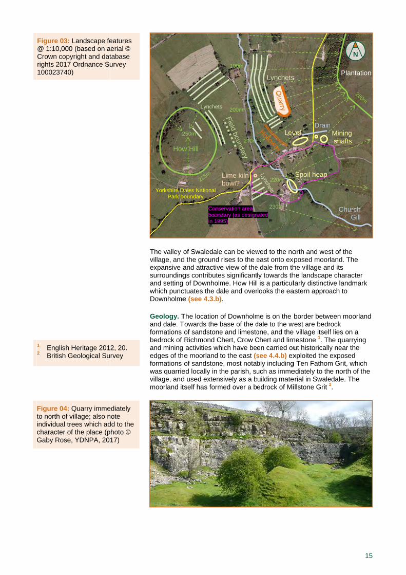
Figure 03: L@ 1:10,000 Crown copyrights 2017 O100023740)
1 English H2 British Ge
Figure 04: Qto north of viindividual trecharacter of Gaby Rose,
Landscape fe(based on aright and datOrdnance Su)
Heritage 201eological Su
Quarry immeillage; also nees which adthe place (pYDNPA, 20
eatures aerial © tabase urvey
2, 20. rvey
ediately note dd to the photo © 17)
The valley ovillage, andexpansive asurroundingand setting which puncDownholme
Geology. Tand dale. Tformations bedrock of and mining edges of thformations was quarrievillage, andmoorland it
Yorkshire DPark b
How
2
of Swaledaled the ground and attractivgs contribute of Downholm
ctuates the de (see 4.3.b)
The location Towards the b
of sandstoneRichmond C activities whe moorland tof sandstone
ed locally in td used extentself has form
Dales National boundary
Consbounin 19
w Hill
250m
Lynchets
e can be viewrises to the ee view of the
es significantme. How Hillale and over).
of Downholmbase of the de and limesto
Chert, Crow Chich have beto the east (se, most notathe parish, susively as a b
med over a b
210m
200m
servation area dary (as design95)
s
Lime kiln bowl?
190m
wed to the noeast onto ex
e dale from thly towards thl is a particulrlooks the ea
me is on the dale to the wone, and theChert and limen carried ousee 4.4.b) exbly includinguch as immeuilding mateedrock of Mi
nated
220m
230m
Lynchets
Lev
orth and wesxposed moorlhe village anhe landscapelarly distinctiv
astern approa
border betwewest are bedre village itselfmestone 1. Thut historicallyxploited the e
g Ten Fathomediately to theerial in Swaleillstone Grit 2
s
Drain
Spoil heap
vel
1
st of the land. The d its
e character ve landmarkach to
een moorlanrock f lies on a he quarrying y near the exposed
m Grit, whiche north of the
edale. The 2.
N
Plantatio
Church Gill
Mining shafts
15
k
nd
e
on

16
4.2 Historic Development and Archaeology
This section describes the origins, archaeology and historic development of Downholme.
a) Origins and Historic Development of the Area
The development of the settlement provides a historical value and its surviving historic layout also provides an evidential value, which is part of the special interest of Downholme (see 3.0).
Origins. The earliest visible archaeological remains of settlement in the area are likely to date from the Iron Age. How Hill, a large defended settlement or univallate hillfort c300m to the west of the current village, consists of a ditch and bank around the summit of the hill, with surviving evidence of several internal round houses of probable Late Iron Age or Romano-British date 3. It occupies a commanding position, and is likely to have been built to control the southern approaches to Swaledale. In addition, to the north of Downholme Quarry are the remains of a linear settlement directly associated with a surrounding coaxial field system, again thought to be late Iron Age or Romano-British in date 4.
The settlement of Dune, surveyed in 1066, is recorded in the Domesday Book 5, although this Old English name rather indicates earlier origins, meaning “from/amongst the hills”. The suffix holme was added later, and may have derived either from Old English (holegn meaning “holly”) or Old Norse (holm meaning “island”).
Historic Development. The village probably developed across the main medieval route between Richmond and Reeth, which at the time lay further south than the present route (B6270/A6108) 6. It was built up around a central green along the road, with narrow parallel strips of land (crofts and tofts) running out from the core of the village; some of this former layout is still evident today. The remains of an extensive system of medieval lynchets, ridge-and-furrow earthworks and former field boundaries survives around the north, west and south of the village 7, superseding earlier coaxial field systems 8 and giving an impression of the historic development of growing crops in the area, which was later superseded by grazing animals on pasture land. In addition, there are records of small-scale lead mining having been carried out from the late 14th century onwards on Downholme Moor and Thorp Edge to the north 9. The Church of St Michael & All Angels (Figure 32), parts of the graveyard (Figures 33 & 34), the ruins of Downholme Hall (Figure 35) and some of its reused decorative features at Home Farmhouse (Figure 36) are surviving stone-built remains of the medieval settlement.
Figure 05: How Hill when viewed from the east, with lynchets in the field in the foreground and to the base of the hill in the background; also note the line of trees along the field boundary at the foot of How Hill, in front of the lynchets (photo © Gaby Rose, YDNPA, 2017)
3 Archaeological Services University of Durham, 2008.
4 Wessex Archaeology, 2002.
5 Open Domesday 6 On Site Archaeology, 2000. 7 Catterick Training Area:
Integrated Land management Plan, 2000.
8 Wessex Archaeology, 2002. 9 Barker, 1993. 10 On Site Archaeology, 2000.

17
Over time, the village green was gradually encroached upon by newer buildings and enclosures, as evident on a plan of 1778 10. This map also indicates that there may have been a second village green further to the west at this time, comprising an open space where the village main street meets the road south to Walburn, now the A6108.
In 1987 the base of a possibly early 17th century ore-hearth was discovered in a redundant outbuilding in Downholme 11, suggesting that lead was being processed in the village at that time. Lead and coal mining took place at Downholme and on the nearby moors in the 18th century; the coal pits were redundant by the mid 19th century, and the local lead mining industry also fell into decline and had ceased by the 1880s, resulting in a dramatic decline in the population 12 (see 4.4.b). Consequently, a number of buildings present in and around the core of the village during the 1850s were no longer extant by the end of the century. In the 1860s or 70s, the Vicarage (Figure 37) was built to the immediate west of the junction into the village from today’s A6108. Overall, however, it is notable that the village layout has changed relatively little since the middle of the 19th century, and the majority of buildings standing in the village today were built before this period (see 4.4.c).
From the 1930s onwards, the Ministry of Defence (MoD) purchased various buildings in Downholme. Over the next few decades, the whole village and surrounding land came under MoD ownership and served the
Figure 06: Later historical development @ 1:10,000 (graphics © Gaby Rose, YDNPA, 2017) Before c1850 c1850-90
c1890-1910 c1910-today
11 Barker, 1993. 12 Censuses of Wensleydale
and Swaledale
18
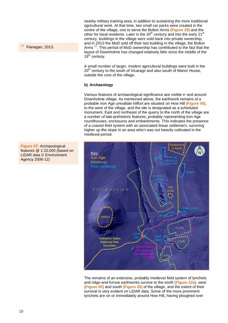
Figure 07: Afeatures @ 1LiDAR data Agency 2006
13 Flanagan
Archaeologic1:10,000 (ba© Environme6-12)
n, 2013.
cal ased on ent
nearby militagricultural centre of thother for loccentury, buand in 2013Arms 13. Thlayout of Do19th century
A small num20th centuryoutside the
b) Archaeo
Various feaDownholmeprobable Iroto the west monument.a number oroundhouseof a coaxialhigher up thmedieval pe
The remainand ridge-a(Figure 05)survival is vlynchets are
Key: Iron AgMedievPost-m
YorNa
H
F i e l
tary training work. At tha
he village, oncal residentsildings in the3 the MoD sohis period of ownholme hay.
mber of largey to the south core of the v
ology
atures of arche village. As on Age univaof the village
. East and noof late-prehises, enclosurel field systemhe slope in aeriod.
ns of an exteand-furrow ea) and south (very evidente on or imme
ge val edieval
rkshire Dales ational Park boundary
Hillfort
d s y s t e
area, in addat time, two sne to serve ths. Later in thee village wereold off their laMoD ownersas changed
er, modern ah of Vicaragevillage.
haeological smentioned a
allate hillfort e, and the sitortheast of thtoric featureses and emba
m with an assan area which
nsive, probaarthworks su(Figure 26) oon LiDAR daediately arou
Consearea bo(as desi
in
e m
Lime kiln
ition to sustasmall car parhe Bolton Arme 20th centurye sold back iast building iship has contrelatively littl
gricultural bue and also so
significance aabove, the eaare situated te is designa
he quarry to ts, probably rankments. Thsociated lineah was not he
bly medievaurvive to the nof the villageata. Some ofund How Hill,
ervation oundary ignated n 1995)
Cro
Quarry &kilns
Spoil heap
Level
aining the morks were creams (Figure 2y and into thnto private oin the villagetributed to the since the m
uildings wereouth of Mano
are visible inarthwork remon How Hill
ated as a schthe north of trepresenting his indicates ar settlemen
eavily cultivat
l field systemnorth (Figur
e, and the extf the more pr, having plou
Hut circle
Settlement & fields
Crofts
ofts
Crofts
&
Mining
l
M
ore traditionaated in the 29) and the e early 21st
ownership, , the Bolton
he fact that thmiddle of the
e built in the or House,
and aroundmains of a
(Figure 05),heduled the village arIron Age the presenct, surviving ted in the
m of lynchetse 22a), westtent of their rominent ughed over
N
Quarry
ine shafts
al
he e
,
re
ce
s t

19
the Iron Age earthworks, and also in the fields immediately adjacent to Chapel Beck, north of the settlement.
Various earthworks platforms, enclosures and other features survive in and adjacent to the current village, and these are likely to represent parts of the settlement which fell out of use either in the medieval or post-medieval period. South of the triangular road junction to the west of Downholme is a substantial linear earthwork, which may represent the course of an earlier road. This suggests that the green to this side of the settlement may have been larger in the past, as supported by the 1778 plan of the village (see 4.2.a). Further south, about 10m from the main road, is a circular stony embankment with a break in the west side, which is likely to have been a post-medieval limekiln.
Aside from the main quarry, which produced a type of sandstone known as Ten Fathom Grit (see 4.1.c), there are numerous smaller post-medieval quarry scoops visible at various points around the village. There are also several post-medieval mining sites which are now evident as earthworks. These include spoil heaps near Manor House, a level to the south of North House (Figure 44) and another spoil heap to the west of it (Figure 19), a small number of pits near the reservoir to the northeast of the village (Figure 15), and White Earth Mines to the north of the settlement. These remains indicate a history of coal and lead mining activity in the local area (see 4.4.b), with evidence for open cast pits, hushing and shaft sinking.
Information about individual historic environment features and surveys can be found on the Yorkshire Dales National Park Historic Environment Record (HER), a dynamic computer database linked to a Geographic Information System (GIS).
4.3 Spatial Analysis
This section describes the character and interrelationship of spaces, as well as the key views and vistas of Downholme. Attractive views and well-related spaces provide an aesthetic value, which is part of the special interest of Downholme (see 3.0).
a) Character and Interrelationship of Spaces within the Area
A significant part of the character of Downholme is formed by the informal arrangement of houses and agricultural buildings along the main street (Figure 17) and the two cul-de-sacs, which branch off to the north (Figure 19) and south, with the building frontages facing onto the roads. The junction of the main street with the southern cul-de-sac, also known as Silver Street, is marked by Nos. 9 and 10 forming a prominent corner, leading the view up the road to Manor House which occupies an elevated location at the other end (Figure 18).
The majority of open spaces including agricultural enclosures and domestic gardens radiate out from the rear of the buildings, and the remains of village greens are still present in the centre of the settlement (Figure 09) as well as at the junction to the west (Figure 10). The largest green space in the settlement is between the main street and the cul-de-sac to the north (Figure 11). These open green spaces not only make a visual contribution towards the character of the village, but also provide some relief from the building frontages closely arranged around the road. Furthermore, there is a close relationship between the more confined domestic spaces within the village and the expansive surrounding enclosed pastoral land, emphasised further by the extensive views of Upper Swaledale from within parts of Downholme (see 4.3.b).

220
Figure 08: D@ 1:5,000 (bCrown copyrrights 2017 O100023740)
Definition of sbased on maright and datOrdnance Su
space ap © tabase urvey
The view inpresence oposition of tlandmarks,37) to the wof the mainalongside thvillage, as omost promihead of themain streetwhich otherkilometer tolandmark frAll Angels (village and between DoSwaledale,
Vicarag
Ch
nto Downholmof numerous the village w as depicted
west of the m area of setthe road leadone approacnent landma
e village (Figt (Figure 16)rwise screeno the north ofrom within th(Figures 20 the Vicarage
ownholme an such as Ma
ge
1
hurch
me from outsrows and clu
within a dip in on the map
main junction lement and o
ding into the vches from theark is a pair oure 15). The) and stand cn the village ff the village, e wider land& 21), whiche (Figure 23nd the other rske and Hu
2
4
side the villagusters of tree
the side of tbelow, incluinto Downho
overlooks thevillage. On the moorland roof small agricese two buildclear of trees from the eastand formingscape, is the
h demonstrat), as well as nearby towndswell.
3
2
ge is limited es (see 4.4.ethe valley. Thde the Vicarolme, which e open greenhe other sideoad to the nocultural buildings are at th
s and landscatern view. Ab
g a very prome Church of Stes the visua a wider rela
ns and village
Prombuildi Promboun Land Goodspace
Fabu
3
by the ), and the he key rage (Figure stands proudn triangle e of the orth-east, theings at the he top of theape features bout a
minent St Michael &al link to the ationship es in
minent ing frontage
minent dary wall
mark
d internal e
arm uildings
N
d
e
e
&

21
The map above shows, besides prominent building frontages and boundary walls, good internal spaces which are considered to add distinctiveness to the character and interest of the settlement and the quality of life of its inhabitants; please note that there are currently no officially designated ‘important open spaces’ under Policy C13 of the Yorkshire Dales National Park Local Plan 2015-30.
Space 1: A green triangle enclosed by roads forming the junction between the A6108 and the tank road to Richmond via Hudswell. It is thought that this green space was once larger, and part of a possible second village green incorporating an older part of the settlement, as indicated by earthworks in the field to the south (see 4.2). This space helps to define the main (eastern) entrance into the village, and its prominence is further emphasised by the dominant presence of the Vicarage (Figure 37) to the immediate west of the A6108. Two attractive cast-iron reflective signs for Downholme are fixed to a stone base on this green, although they are overwhelmed by a cluster of modern road signs and advertising billboards (Figure 53).
Space 2: The village green in the centre of Downholme, now consisting of a small number of green parcels divided by modern road surfacing. This space provides a central area to sit, with attractive views out of the village into Upper Swaledale (Figure 20), and helps to soften the impact of the rows of buildings to either side of the road (Figure 17a). The green also provides a communal space where noticeboards, a telephone box, postbox, refuse bin and grit box are conveniently sited, although they do draw some attention away from the landscape views. The openness of this space is further visually expanded into the field to the east of the junction with Silver Street, the southern cul-de-sac. The line of telegraph poles along the main street is a major detractor, as is the encroachment of hardstanding onto the green spaces (see 4.4.g).
Space 3: An enclosed parcel of land between the main street and cul-de-sac to the north (Figure 19), ending at North House (Figure 46); along its
Figure 10: Space 2, looking down/west along the main street, with the pub to the left in the background, and a line of telegraph poles in front of it; note the phone box, etc. along the boundary wall enclosing the Bolton Arms car park (photo © Gaby Rose, YDNPA, 2017)
Figure 09: Space 1, to the left/ west of the village, at the junction of the tank road with the A6108; note the mature sycamore and copper beech tree on the green, as well as the amount of signage near the A6108 (photo © Gaby Rose, YDNPA, 2017)

22
northern edge is an old lead level, its entrance marked by a culvert (Figure 44). This wide green space separates the rows of buildings along both roads, and helps to create an environment within the village which is more open. There is no public access, so it has only a visual contribution.
Space 4: Part of a field to the west of Silver Street, between Nos. 9 & 10 (Figure 17) and Manor House, which is bounded by a linear embankment to the west and drystone walling to the other three sides. Church Gill runs parallel to the road and then turns sharply west along the north boundary.
b) Key Views and Vistas
The fine landscape setting and well-kept historic environment provide a communal value by attracting walkers and visitors into the area and providing a high-quality place to live for residents, which is part of the special interest of Downholme (see 3.0). However, the landscape can only be appreciated if views exist that embrace it, as is the case with Downholme. The map below identifies important views into, out of and within the conservation area, as well as focal points such as landmark structures or open or enclosed spaces that draw the eye.
Figure 11: Space 3; Top: looking north towards North House from a public bench on verge along main street; Bottom: looking south from the opposite direction, near the level entrance (photos © Gaby Rose, YDNPA, 2017)
Figure 12: Space 4 on the right/ west of Silver Street, with Manor House Farm in the background (photo © Peter Reynolds, YDNPA, 2016)

Figure 13: K1:5,000 (basCrown copyrrights 2017 O100023740)
Figure 14: Vdown/south from the roaMoor; note ton the villageRose, YDNP
Key views @sed on map ©right and datOrdnance Su
View 1, lookinacross the vd over Downhe impact ofe (photo © G
PA, 2017)
@ © tabase urvey
ng village nholme f trees Gaby
View 1: Taend, with thDownholmewithin a natcover (see
Ch
Vicarag
10
14
nk road leadhe buildings se Moor, looktural dip in th4.4e).
hurch
ge
12
11
13
ding to the enstarting to aping south. No
he landscape
8
9
6
ntrance into tppear from bote that the se and is com
7
4
5
the village atbehind the rasettlement haplemented b
Exter Intern Landm
Fab
1
2
3
2
t its eastern ised edge ofas developed
by a good tre
N
nal view
nal view
mark
arm uildings
23
f d e

24
View 2: Another view from the north down the tank road towards the eastern entrance into the village, at a closer distance. There are scars of former mine shafts on the moor to the left/east in the foreground. Two small but prominent agricultural buildings provide a focal point at the head of the village.
View 3: As one enters the village from the east, the left/south side of the main street is dominated by No. 16; note the historic right-hand/northern section of the building facing the road, and the modern extension to the left/south with a staggered roofline. A grit box to the right/north is set within an attractive low stone wall on the grass verge at a short distance to the road. However, the view is channelled further down the main street, visually widened by the green verges to both sides, to buildings in the village’s core and the elevated landscape backdrop.
Figure 15: View 2, with remains of mine shafts to the left and two prominent farm buildings towards the centre serving as a focal point when approaching the village from the north (photo © Gaby Rose, YDNPA, 2017)
Figure 16: View 3, looking down/west along the main street with green verges to both sides; note landscape backdrop (photo © Gaby Rose, YDNPA, 2017)

25
Views 4a-d: Views looking up/east along the main street starting at the central village green (Figure 10), and gradually moving towards the eastern entrance of the village. A line of prominent telegraph poles has a negative impact on these views (see 4.4.g). Note the linear yet informal arrangement of buildings along the road, often set back behind the green verges along the main street, and their staggered effect as one moves up/east on the sloping ground (see 4.3.a). Again, the two farm buildings form a focal point at the top/east end.
Figure 17: Views 4a-d, looking up along the main street, starting at the central village green, and moving up towards the eastern end of the village, with the two farm buildings as a focal point; note grass verges along street and a number of small interesting trees; on photo a, note the bench on the green island and modern porches to houses on either side of the street; on photo c, note the historic one-bay extension under the same roofline and the street lamp attached to the front building corner, which has remnants of MoD green paint (photos © Gaby Rose, YDNPA, 2017)
2
w
j
©
26
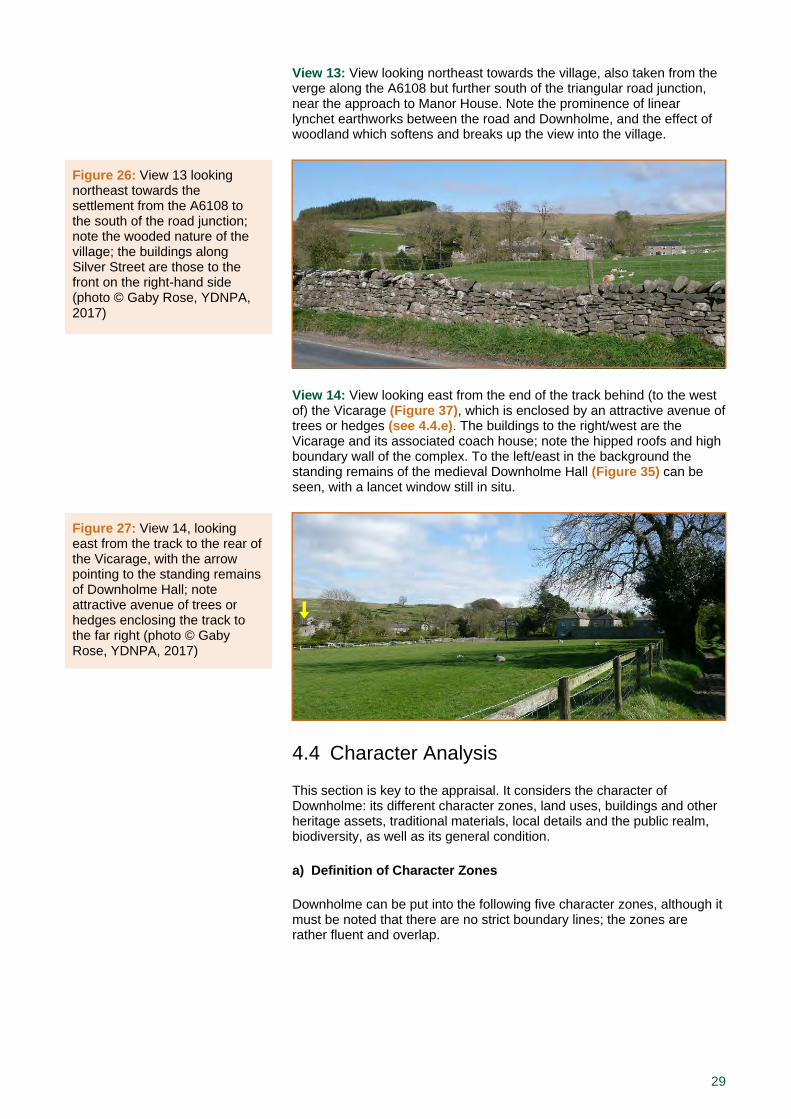
Figure 20: Vwith How Hilbackground the right poinnote the line(photo © Ga2017)
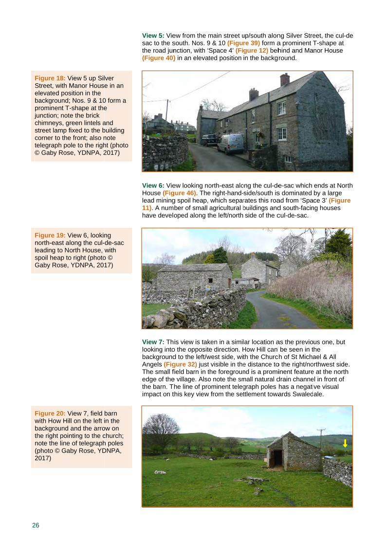
Figure 19: Vnorth-east aleading to Nospoil heap toGaby Rose,
Figure 18: VStreet, with Melevated posbackground;prominent T-junction; notchimneys, gstreet lamp fcorner to thetelegraph po© Gaby Ros
View 7, field ll on the left iand the arronting to the c
e of telegraphaby Rose, YD
View 6, lookinlong the cul-orth House, o right (photoYDNPA, 20
View 5 up SilManor Houssition in the ; Nos. 9 & 10-shape at thete the brick reen lintels afixed to the be front; also nole to the righse, YDNPA, 2
barn in the
ow on church; h poles DNPA,
ng de-sac with
o © 17)
lver e in an
0 form a e
and building note ht (photo 2017)
View 5: Viesac to the sthe road jun(Figure 40)
View 6: VieHouse (Figlead mining11). A numhave develo
View 7: Thlooking intobackgroundAngels (FigThe small fedge of thethe barn. Thimpact on t
ew from the msouth. Nos. 9nction, with ‘) in an elevat
ew looking nogure 46). Theg spoil heap, ber of small oped along t
is view is tako the oppositd to the left/wgure 32) justfield barn in te village. Alsohe line of prothis key view
main street u9 & 10 (FigurSpace 4’ (Fited position
orth-east aloe right-hand-which separagricultural b
the left/north
ken in a simile direction. H
west side, witt visible in thethe foregrouno note the smominent teleg
w from the set
up/south alonre 39) form agure 12) behin the backg
ong the cul-deside/south isrates this roabuildings andside of the c
lar location aHow Hill can th the Churce distance tond is a promimall natural dgraph poles ttlement towa
ng Silver Strea prominent Thind and Maround.
e-sac which s dominated ad from ‘Spad south-facincul-de-sac.
as the previobe seen in t
ch of St Michao the right/noinent featuredrain channehas a negatiards Swaled
eet, the cul-dT-shape at nor House
ends at Nortby a large ce 3’ (Figure
ng houses
us one, but the ael & All
orthwest sidee at the northel in front of ve visual ale.
de
th
e
. h

27
View 8: View towards the Church of St Michael & All Angels taken from the permissive access track near the lime kiln (Figure 42) at the quarry immediately to the north of Downholme. The church and its remote attractive setting form part of a picturesque view into Swaledale.
View 9a & b: View north into Swaledale along public footpath to Hudswell, with the Church of St Michael & All Angels being the focal point. Also note the stepped profile of the field in the foreground, resulting from medieval cultivation lynchets, which is dissected by a line of prominent telegraph poles. A modern culvert has been inserted below the road and boundary wall near the church.
Figure 21: View 8, looking towards the church from near the quarry to the north of the village (photo © Gaby Rose, YDNPA, 2017)
Figure 22: Views 9a & b, looking towards the church from the public footpath between Downholme and Hudswell; note the lynchets in the foreground, as well as the wooded gill on the left (a) which joins a drain passing through a modern culvert (b) (photos © Gaby Rose, YDNPA, 2017)

28
View 10: View from the Church of St Michael & All Angels along the access track to the south, which is lined by hedges (see 4.4.e). It is likely that this track was historically used as a corpse road. Note the Vicarage (Figure 37) in the background to the right/south side, built in the second half of the 19th century.
View 11: View from the green triangle at the road junction (‘Space 1’) (Figure 09) which leads from the A6018 to the western entrance into Downholme. This view of the village is broken up and softened by woodland, and the trees of Church Gill are just visible to the left/north (see 4.4.e). There is yet another village sign at the tip of the green, in addition to the signage accumulation behind (Figure 53).
View 12: View looking east towards Manor House (Figure 40), taken from the verge along the A6108 immediately to the south of the triangular road junction. Manor House and its associated agricultural complex to the right/south dominate this view, with fragmentary remains of a field system visible in the foreground.
Figure 23: View 10, along church track lined by hedges, with the arrow pointing to the Vicarage in the distance (photo © Gaby Rose, YDNPA, 2017)
Figure 24: View 11, looking east towards Downholme from the road junction with the A6108, with Church Gill to the left and yet another village sign ahead (photo © Gaby Rose, YDNPA, 2017)
Figure 25: View 12, looking east towards Manor House from the A6108 just south of the green, with fragmentary remains of a field system visible in the foreground (photo © Gaby Rose, YDNPA, 2017)
29
View 13: View looking northeast towards the village, also taken from the verge along the A6108 but further south of the triangular road junction, near the approach to Manor House. Note the prominence of linear lynchet earthworks between the road and Downholme, and the effect of woodland which softens and breaks up the view into the village.
View 14: View looking east from the end of the track behind (to the west of) the Vicarage (Figure 37), which is enclosed by an attractive avenue of trees or hedges (see 4.4.e). The buildings to the right/west are the Vicarage and its associated coach house; note the hipped roofs and high boundary wall of the complex. To the left/east in the background the standing remains of the medieval Downholme Hall (Figure 35) can be seen, with a lancet window still in situ.
4.4 Character Analysis
This section is key to the appraisal. It considers the character of Downholme: its different character zones, land uses, buildings and other heritage assets, traditional materials, local details and the public realm, biodiversity, as well as its general condition.
a) Definition of Character Zones
Downholme can be put into the following five character zones, although it must be noted that there are no strict boundary lines; the zones are rather fluent and overlap.
Figure 26: View 13 looking northeast towards the settlement from the A6108 to the south of the road junction; note the wooded nature of the village; the buildings along Silver Street are those to the front on the right-hand side (photo © Gaby Rose, YDNPA, 2017)
Figure 27: View 14, looking east from the track to the rear of the Vicarage, with the arrow pointing to the standing remains of Downholme Hall; note attractive avenue of trees or hedges enclosing the track to the far right (photo © Gaby Rose, YDNPA, 2017)

330
Figure 28: C1:5,000 (basCrown copyrrights 2017 O100023740)
Character zosed on map ©right and datOrdnance Su
nes @ © tabase urvey
Zone 1: Muconservatiostreet, whici.e. the buildsouth, histohighest in throad arrangbeen subdivoriginally deprovides evalong the mprovides a within the san importan
Zone 2: Almdesignated House Farmdistance to
4
uch of this zoon area (Figuch is in the Ndings aligninorically knowhis (main) pagement is a cvided by dryerived from tvidence of itsmain street, rdistinctive st
settlement (Fnt area of op
most all of th as part of thm (Figure 40the southern
4
5
one has beenure 54), exceational Park
ng the main swn as Silver Sart of the villacharacteristicystone walls ithe historic cs former landising up the taggered effe
Figure 17). Tpen space wit
his zone is ouhe 1995 cons0), which liesn edge of the
2
3
n designatedept for the no. It comprisestreet and cuStreet. The buage. To the sc ‘oval’ shapento smaller proft layout (s
d use. The linslope towardect when loohe central vithin the cent
utside the Naservation ares in an elevate village. It is
3
d as part of thorth side of thes the core oful-de-sac forkuilding denssoutheast of ed field systeparcels of lansee 4.2.a), annear grain of ds the easterking up the rllage green (tre of this zon
ational Park aea. It focusseted location as highly visib
1
he 1995 he main f the village, king off to theity is the the L-shape
em which hand. It nd still developmen
rn moorland,road from (Figure 10) ine.
and has beees on Manor and at somele both from
N
e
d as
nt
is
n

31
the A6108 outside the settlement (Figure 25) and from along Silver Street. Regarding the latter, the sloping landform combined with the buildings and drystone walls to either side of the cul-de-sac creates a confined area, channelling the view along the road towards the farm (Figure 18), where there are clusters of different sized buildings with a variety of historic functions, as well as earthwork remnants of hushing activity. There is a visual separation between this zone and the main settlement in this location. However, like Manor House, the buildings along Silver Street are clearly visible when viewed from a distance on the A6108 (Figure 26), providing a setting to the farm. The field separating the main road from the cul-de-sac contains the earthwork remains of numerous features, providing evidence of historic features which are no longer present.
The following Zones 3 – 5 are within the Yorkshire Dales National Park and were not designated as part of the 1995 conservation area.
Zone 3: This area is located to the north of Zone 1 and centres on the northern cul-de-sac which ends at North House (Figure 46). It is visually separated from the rest of the settlement by a substantial embankment along its south side of the road (Figure 19), formed by mining spoil from the level situated between the cul-de-sac and the main road through Downholme (‘Space 3’) (Figure 11). There is further evidence of former mining inside this zone, comprising the mine shafts on the edge of the moorland (Figure 15), which are ‘linked’ to the spoil heap area via a drain. Along the north side of the cul-de-sac are a number of buildings, comprising smaller agricultural buildings and sheds (Figure 31), and a couple of houses. The zone has fine views to How Hill and into Swaledale to the north, as well as a glimpse of the church from inside the village (Figure 19). Views to the west include the ruins of Downholme Hall (Figure 35), behind the Bolton Arms public house, which is screened from view along the main street.
Zone 4: This zone is centred on the green triangle (Figure 09) and the Vicarage (Figure 37) at the road junction to the west of Downholme. At the triangle, the village is largely screened from view by the form of the landscape combined with areas of woodland (Figure 24). Defining the western limit of the settlement yet at some distance, the Vicarage is an imposing building with a hipped roof, high boundary walls to the north and a trackway to its rear (west) which once provided the access to the coach house. From the end of the track, views past the Vicarage to the village display the standing remains of Downholme Hall (Figure 27).
Zone 5: The largest and most open of the character zones, this area includes the isolated Church of St Michael & All Angels (Figure 32) to the north-west, connected to the village both by the Public Right of Way cutting through fields to the north of the settlement (Figures 21 & 22), and the A6108. From the church, there is a visual connection to the Vicarage (Figure 23). The large quarry directly north of Downholme (Figure 04) with an associated lime kiln (Figure 42), the small office building of the quarry foreman and two explosive magazines built into the hillock provides a viewpoint from which the church and the village can be seen, linking these features together, as well as into the wider landscape. There are existing field boundaries and well-defined earthwork features which enhance the character of this zone, including impressive rows of lynchets to the east of the A6108 and near the church. Small watercourses including Church Gill run from the village though this zone, towards the River Swale.

32
b) Activity and Prevailing of Former Uses and Their Influence on Plan Form and Buildings
Stone quarrying, agriculture and mining have all played an important part in the historic development of the village (see 4.2.a).
Census Records 14. In 1841, the village population was around 110 with an average (mean) age of 21, and the main occupation was farming or agricultural labour. Slate quarrying and lead mining were active, and it is very likely that the lime kiln at Downholme Quarry (Figure 42) was then in use, burning lime for the use of building materials and improvement of the land. Furthermore, a school was present, which had been built around 1814 (Figure 41). There were two shoemakers, four wheelwrights and two butchers in the village, although there was no record of public houses or innkeepers. There was no vicar present in the village. The village had around 23 separate households, with one house described as being unoccupied.
In 1871, the village population had reached a peak at just over 130 with an average age of 24, although the total number of agricultural labourers had decreased dramatically. Quarrying and lead mining were still active, although the following decade saw the loss of the lead mining industry in Downholme. There were two public houses – the Bolton Inn (although named as the Bolton Arms on all historic OS maps) and King’s Head (which on the mid-C19 map is called The King William P.H.) – a newly built vicarage (Figure 37), the school with around 30 pupils, one blacksmith and a general shop. The village had nearly 30 separate households, and many residents were employed as domestic servants.
In 1891, the village population had decreased dramatically to around 60 with an average age of 32, reflecting an ageing population with fewer young residents. By this time the local lead industry had vanished, although the quarry (Figure 05) was still active. The number of farmers and agricultural workers had declined, and the number of local schoolchildren was just five. For the first time, the village had a post office with a resident post mistress. The two public houses remained open, and there was still a general shop. Overall, the census records reflect both the local decline of the lead industry at this time, and the national trend for younger people to move from rural areas into cities to find work. There were around 18 households, with five houses described as unoccupied.
In 1911, the village population was still around 60 with an average age of nearly 34. The King’s Head public house had closed, leaving the Bolton Arms as the only inn in the village. There were only three local schoolchildren, although the school appears to have remained open. Agriculture and quarrying were still active, and the post office employed two staff. However, there was no longer a village shop or butcher, and the overall number of residents of working age was at its lowest point so
14 Censuses of Wensleydale and Swaledale
Figure 29: The Bolton Arms pub; the arrow points to a blocked former door with a flat-arched head made of voussoirs; also note the green painted lintels indicative of the former MoD ownership (photo © Gaby Rose, YDNPA, 2017)

©
Figure 30: Puses @ 1:5,0© Crown copdatabase rigSurvey 1000
Past and pre000 (based opyright and
ghts 2017 Or023740)
sent on map
dnance
far. There whouses not
From the beof Downholinhabitants,now in eithedifferent or Bolton Arm150 years. manufacturcentury, dupublic housthe former psmithy buildThe small bas a smithy
Coach house
Chur
Vi
were around t specified.
eginning of tlme village h, and arounder agriculturamixed histor
ms, having beAnother exisrer (No. 16). e to dwindlin
se is now a repost office (pding (Figurebuilding adjoy, judging fro
Sewa
Dow
rch
icarage
Lime kiln
17 househo
the 20th centuhas been relad 17 househoal or residentrical use. The
een in use assting local buThe school c
ng numbers oesidential dwpresumed to 38) is locateining No. 2 mm its externa
Q
Lime kiln
BoltonArms
Post office
age
V
wnholme Hall
lds, with the
ury to the preatively stableolds. Most butial use, some main comm a public hou
usiness is a tclosed in theof pupils. The
welling (presube No. 11).
ed along the may have alsal appearanc
uarry
n
Le
Level
Smithy?
Smithy n
illage hall
number of u
esent day, the at between uildings in th
me having revmunity buildinuse for at leatraditional sae middle of the former Kinumed to be NThe survivinmain street
so been usedce.
Key: Industrial AgriculturReligiousCommercResidentiOther use Uses withwhite no l
evel
Mine s
l
y
King’s Arms
School
RichmSash
3
unoccupied
he population60 and 80 e village are verted from ang is the ast the last ash window he 20th g’s Head
No. 12), as isg former (Figure 17bd historically
N
use ral use use
cial use al
es
h central longer exist
shafts Reservo
mondshire Windows
33
n
a
s
).
ir

34
c) Quality of Buildings and Their Contribution to the Area
Downholme’s attractive vernacular buildings including its traditional farm buildings provide an evidential value which contributes towards its special interest (see 3.0).
Overview. The majority of buildings in Downholme were not designed by architects, but constructed by local people in the vernacular style. Houses are largely arranged around the main street through the village and the two cul-de-sacs which branch off to the north and south (Figures 17-19), and the predominant orientation of buildings is roughly northeast-southwest, with the exception of those buildings closest to the junction to the west. This arrangement gives the appearance of small clusters of buildings, with rooflines staggered irregularly up the slope to the east, interspersed and broken up by frequent small parcels of woodland or single trees (see 4.4.e).
Most of the existing dwellings were probably built in the late 18th or early 19th centuries (Georgian period). Typically, such surviving houses are made of limestone or sandstone rubble, with dual-pitched roofs of local stone slates laid in diminishing courses. They often have stone chimney stacks to one or both gable ends, although some of them have been replaced in the 20th century using bricks non-typical to the area (Figure 18), during the period of Ministry of Defence ownership. In general, these simple stone-built houses were built without porches, although some were added later to various properties, using a variety of materials and styles (Figures 17a, 36 & 40).
The houses generally seem to have originated as three-bay, two-storey buildings with symmetrically arranged windows and central doorways. Most windows and doors dating from the 19th century onwards have plain surrounds, without formal jambs. A number of buildings show evidence for blocked former openings within the masonry incorporating a rustic form of flat-arched head. Whilst in some cases these flat-arched openings appear to have been superseded by later openings with plain-slab 19th-century lintels (Figure 29), in another case such an opening was inserted later on a late 18th-century outbuilding (Figure 39). On some structures, flat-arched windows are still in use (Figures 40 & 41). When analysing the different buildings, it appears that the flat-arched openings date from around 1800, or slightly later (former school).
A number of the vernacular houses in the village were historically subdivided or extended to provide additional units of accommodation, or to provide a separate area for agricultural or small-scale industrial use. Traditional extensions can take the form of an additional bay or a lean-to added onto the main house, often with a lower roofline (Figure 46) or of a single storey, if the extension was designed for a subsidiary use. Where the roofline of the main house has been carried through into a side extension (Figure 17c), this can indicate that the extension was added to provide additional accommodation or another residential unit. Today, a number of houses now also include modern extensions, ranging in size and form from simple lean-to additions to larger two-storey gabled extensions (Figure 16).
Despite the strong vernacular tradition in Downholme, a small number of buildings were built in a more “polite” style, including features not typical to the local area. The most notable example of this is the Vicarage (figure 37), which incorporates a hipped roof, a bay window, and a plan form which differs from more typical Dales farmhouses. Such displays of polite architecture were often intended historically to distinguish a property from the more ‘ordinary’ traditional houses in the area, and as a display of perceived status or wealth.

35
Finally, a number of smaller, freestanding traditional buildings are scattered around the area; these were built for a variety of functions, including agricultural (e.g. field barns (Figure 20)) or communal (e.g. school house (Figure 41)). In contrast to the typical solid masonry construction techniques, since the 19th century, timber and metal framed structures have been erected using corrugated iron and other cladding materials for walls and/or roofs. In Downholme such construction is mostly limited to agricultural, storage or temporary purposes, and their scale and proportions often further differentiates them from the traditional Dales stone buildings.
Listed buildings. Listed buildings are buildings of special architectural or historic interest designated under the Planning (Listed Buildings and Conservation Areas) Act 1990 and are formally listed on the National Heritage List for England maintained by Historic England. There are over 2,120 listed buildings in the National Park. Details of all listed buildings can be found in the Authority’s Historic Environment Record and on the ‘National Heritage List for England’ website. The designation protects the inside as well as the outside of a listed structure, even though interiors are not always featured in the list description. Furthermore, structures fixed to it or within the curtilage of a listed building and pre-dating 1948, such as boundary walls, outbuildings, enclosures and gates, are also protected by the listing.
Downholme has six listed buildings, with one of them being outside the National Park. Their locations are marked red on the map at the back (see 7.4). None of them are currently registered as being ‘at risk’, but there is one ‘vulnerable’ listed building, Downhall Hall Ruins, see below. The descriptions in the following paragraphs are based on the list entries, unless stated otherwise.
Church of St Michael & All Angels, grade II* listed –
Church C12 origins, with subsequent alterations in C13, C14 and
C15; significant restorations and alterations in the C19 Rubble with ashlar dressings, artificial slate roof Nave with north aisle and south porch, chancel with north
aisle Church with decorative features from a variety of periods,
including C12 font with cable moulding, Romanesque doorway, C14 decorated lancet window, early Gothic Revival windows, C12 carved stone heads, with one possibly Iron Age “Celtic” stone head reused
Current condition: good
Figure 31: Timber-framed shed with corrugated cladding to north of village (photo © Gaby Rose, YDNPA, 2017)

36
Coffin approx. 3 metres south of chancel door of Church of St Michael & All Angels, grade II listed –
Medieval coffin with cover C13 or C14 Sandstone Coffin hollowed out in body shape, with chamfered cover;
heavily eroded outline of a foliate cross on upper surface Current condition: good
Cross approx. 10 metres south of Church of St Michael & All Angels, grade II listed –
Possibly medieval cross base with renewed shaft Cross base reputedly C15, shaft probably C19 Ashlar sandstone Two square steps and cross base; monolithic shaft with
Celtic head Current condition: good
Figure 32: Church of St Michael & All Angels (photo © Gaby Rose, YDNPA, 2017)
Figure 33: Coffin approx. 3 metres south of chancel door of Church of St Michael & All Angels (photo © Gaby Rose, YDNPA, 2017)

37
Downholme Hall Ruins, grade II listed –
Ruins of medieval hall house Probable C13 origins; a documentary record of the hall
survives from the C16 Rubble with small amount of ashlar detailing, no surviving
roof or first-floor fabric Interpreted as a first-floor hall house with a solar to the
west and a hall above the barrel-vaulted undercroft Surviving fabric includes a lancet window to the
undercroft, suggestive of a C13 date; much original fabric had been robbed or removed prior to the date of listing
The former hall house was probably built by the de Herford family during the 13th century, and abandoned later during the 16th tenure of the Scrope family 15
Current condition: ‘vulnerable’ due to maintenance issues such as vegetation growth and eroded mortar
Figure 34: Cross approx. 10 metres south of Church of St Michael & All Angels (photo © Pete Wainwright, YDNPA, 2016)
Figure 35: Downholme Hall ruins (photos © Pete Wainwright, YDNPA, 2016)
15 Turnbull & Walsh, 2004.

38
Home Farmhouse (outside National Park), grade II listed –
Farmhouse C17 with later alterations. Rubble with ashlar dressings, artificial slate roof 2-storey building with central gabled porch, rear
projecting single-storey wing with blocked fire window surrounds
C17 chamfered ashlar surrounds to doorway with triangular soffit to lintel, 2-light chamfered mullion windows, kneelers carved with decorative female heads, corbels with female and male carved heads, decorative features reputedly reused from Downholme Hall
Current condition: good
The Vicarage, grade II listed –
Vicarage with detached outbuildings Built between 1860 and 1870 16 Rubble with ashlar dressings, stone slate roof L-shaped plan with rear wing to right, hipped roof and a
substantial courtyard with detached outbuildings Distinctive mix of polite and vernacular architecture,
situated in a prominent position at the road junction into Downholme
Current condition: good
Local listing. Structures that are not nationally listed but are significant may receive some protection by being designated as locally listed buildings. Local heritage listing is a means for a community and a local authority to jointly identify heritage assets that are valued as distinctive elements of the local historic environment 17. Whilst local listing provides no additional planning controls, the fact that a building or site is on a local
17 Historic England 2016b, 3.
Figure 36: Home Farmhouse which includes reused medieval decorative features; note the traditional porch which has been added later (photo © www.rightmove.co.uk, c2013)
Figure 37: The Vicarage; note the stone posts flanking the iron hand gate in the foreground, and the trees within the garden (photo © Gaby Rose, YDNPA, 2017)
16 Censuses of Wensleydale and Swaledale

39
list means that its conservation as a heritage asset is an objective of the NPPF and a material consideration when determining the outcome of a planning application (NPPF, paragraph 17) 18.
Moreover, Objective F6 of the Yorkshire Dales National Park Management Plan 2013-18 promotes the creation of local heritage lists:
Help local people to look after and make use of locally-important heritage features by publishing criteria that
communities can use to identify, assess and record such features, and use the Local Plan to put in place appropriate
measures for their management by 2015 19.
If such a list was prepared for the Downholme Conservation Area, it would need to include heritage structures that contribute positively to the special character or appearance and comply with some of the following selection attributes 20:
Age Rarity Aesthetic value Group value Evidential value Historic association Archaeological interest Designed landscape Landmark status Social and communal value
The following buildings are some examples of non-listed structures that make a particular positive contribution to the conservation area, and could be considered for inclusion on a local list. Their locations are marked on the map at the back (Figure 54).
Former smithy 21 between Nos. 5 & 6: Previously part of a larger range adjoining No. 6 which was partially demolished in the 20th century, according to map evidence. The surviving building has a possibly reused blocked doorway made of tooled stone jambs and lintel in its road-facing south elevation, probably of 18th century date. Three slit ventilators on the two-storey part indicate another former (original?) use as a barn. Evidence of a relict roofline of a former extension on this elevation further adds to the historic character of the building. A large modern doorway has been inserted into the west gable, for more recent use as a garage. The building is now used for storage, and an application has been made to convert it into a dwelling.
Figure 38: Former smithy between Nos. 5 & 6 (photo © Gaby Rose, YDNPA, 2017)
18 ibid, 4. 19 YDNPA 2013, 13. 20 Historic England 2016b, 9. 21 Planning application
R/19/108, Design & access statement

40
No. 10 and curtilage outbuilding to southwest: The house has a three-bay symmetrical front with a central entrance facing south onto an enclosed rectangular yard (now a garden), bounded by the detached outbuilding to the west and drystone walling to the remaining two sides. The full window and door surrounds are flat-faced and indicative of a late-18th-century date. Roof copings rest on carved stone kneelers, and there is a chimney stack to either gable, the one nearest to the road built in 20th-century brick (Figure 18). Imported roof tiles have replaced traditional stone slates. The detached single-storey outbuilding forms a loose L-shape with the house. It may have been built to accommodate a small number of animals, perhaps as a former piggery. Two doorways and one square, now blocked, window opening face onto the yard, their full flat-faced surrounds likely to be of a similar date to those of house. A further opening, now also blocked, to the right/north of the east elevation appears to have been built later using a crude flat-arch. The roof, which has an unusually flat pitch and therefore suggests later modification, has been replaced with corrugated sheeting.
Manor House: Large farmhouse of L-shaped plan with numerous associated outbuildings, built in an elevated position separated from the main core of the village. It exhibits some more polite architectural features, including a cross-gabled roof with numerous substantial chimney stacks. A number of windows have the same style of flat-arches seen elsewhere in the village. A visually striking porch to the front (south-west) elevation incorporates an unusual design including ashlar quoins, with a round-headed façade flanked by two ball finials.
Figure 39: No. 10 and curtilage outbuilding to the left/southwest; note the imported roof slates to the house; the arrow shows the location of the later, now blocked flat-arched opening (photos © Gaby Rose, YDNPA, 2017)

41
Former School: Modest building to the east of Manor House farm constructed around 1814, with two facing small mono-pitched outbuildings to the immediate north, probably representing former washrooms or privies for the pupils. There is no public access to it. The building is two storeys high, with a small chimney stack to either gable, and windows topped with flat arches as seen elsewhere in the village. The school closed in the middle of the 20th century (see 4.4.b).
Lime kiln at Downholme Quarry: Structure of likely C18 or early C19 date with a curved footprint, and partially built into the slope. To north adjoins a stone retaining wall which incorporates former metal rail tracks. The kiln is constructed of squared sandstone rubble brought to course, and has a round-arched draw hole opening made of voussoirs, with an internal niche in the south-western side. The draw hole is internally lined with firebricks stamped ‘TUDHOE’, indicating that they were manufactured at Tudhoe near Durham. A trackway leads from the draw hole opening to the quarry. Nearby, there are also the small office building of the quarry foreman to the south of the kiln and two explosive magazines built into the hillock, but these are later structures of little architectural quality.
Figure 40: Manor House, with some flat-arched window openings; note the elaborate entrance porch (photo © Gaby Rose, YDNPA, 2017)
Figure 41: Former school with flat-arched windows and two small mono-pitched outbuildings (photo © Gaby Rose, YDNPA, 2017)
Figure 42: Lime kiln at Downholme Quarry, with adjoining retaining wall visible to the left (photo © Gaby Rose, YDNPA, 2017)

42
The residents of Downholme and other consultees are invited to suggest other heritage assets they think should be included on a local list. If you have any suggestions or further information on the above mentioned structures, please phone 0300 456 0030 or send an email to [email protected], and give appropriate reasons, evidence or references for your nomination(s).
d) Traditional Building Materials, Local Details and the Public Realm
Historic features including traditional building materials, local details, as well as features and surfaces within the public realm provide an evidential value which is part of the special interest of Downholme (see 3.0). They can contribute positively to the significance of an area as they have the potential of providing characteristic elements to the buildings and their setting, particularly when well-kept and in good condition. Likewise, inappropriate materials, surfaces and street furniture as well as lost or altered details will have a detrimental effect to some extent and, in extreme cases, even put the whole conservation area at risk.
Traditional materials. The materials used throughout the built environment of Downholme make a significant contribution towards its character. These comprise a mixture of local sandstone and a smaller amount of limestone, in particular a type of sandstone known as Ten Fathom Grit, which was quarried locally and used extensively in Swaledale (see 4.1.c). It generally has a grey colour with characteristic orange iron staining, and was used for constructing drystone walls, rubble building walls and sandstone roofing slates set in diminishing courses. However, since the period of Ministry of Defence ownership within the last century, other imported or off-the-shelf roofing and cladding materials have also been introduced into the village, such as ‘Roman’ roof tiles and corrugated sheeting (see 4.4.c), and numerous chimneys have been rebuilt or added using brick, an unusual building material in Swaledale. In the past, lime mortar was used for the pointing of masonry joints, finished flush with the stonework, but during the twentieth century stonework has often been repointed in cement, which can be destructive to the stone, while joints are sometimes recessed, potentially allowing further accelerated erosion. At the time of writing, only one of the properties in the village (No. 12) is rendered with a white roughcast finish, but it is likely that more properties would have historically been rendered in lime, to provide protection from the elements to the stonework.
Traditional windows are framed in timber with either fixed lights or a sliding-sash design. The majority of windows in the area are still wooden units, although a significant number uPVC frames have also been introduced, including different opening patterns/mechanisms (see 4.4.g). Lintels and sills in most properties throughout the village are generally plain stone slabs, sometimes still painted in green, reflecting the ownership of buildings until recently by the MoD.
In general, the building materials used in Downholme are typical for a Yorkshire Dales village, with the exception of brick and modern roof tiles. Whilst the use of cladding sheets is non-traditional, it is now quite commonly seen throughout the National Park and deemed acceptable, if non-reflective and in ‘natural’ colours. Generally, the textures of the built environment in Downholme are rough and the main colour matt ‘stone grey’, representing the local geology. On the whole it is a harmonious image, one that merges with the surrounding landscape.

Figure 43: Lpublic realm on map © Cdatabase rigSurvey 1000
Local details @ 1:5,000 (rown copyrig
ghts 2017 Or023740)
and (based ght and dnance
The map ab
Local detafairly commthose that alocal distinc
Downholme
(Ach
(B (C D
va (D (E
(F
A J
CB
BB C
B
bove shows
ails. These camon/typical feare more unuctiveness.
e has the foll
A) C18 or oldhamfered doB) Stone gateC) Iron gates
Different styleariety of copD) Pinfold anE) Small culvFigure 44)
O
E
KB
BC
B
N
the locations
an be dividedeatures for thusual or uniq
lowing more
der building foor/window se posts (Figu
s (Figures 37es of drystoneing stones, s
nd small enclverts under ro
F
AH
H
I
G
L
I
GM
NME
s of the featu
d into two cahe Yorkshire que. Both ma
typical featu
features in sturrounds (Fiures 37 & 497 & 49) e walling, incsuch as triangosures oads and oth
P
A
A
G
G B
G
L
L
G
B
D
M
I
I
I
E
ures mention
ategories: thoDales Nation
ake a vital co
ures of local i
tone, such asigures 32, 359)
corporating agular ones
her surfaces
K IARCRO
P O
K
E
Q
D
E
G
I
4
ed below.
ose that are nal Park, and
ontribution to
interest:
s 5 & 36)
a
N
Key:
ndustrial Agricultural Religious Communal Residential Other
43
d

44
(F) Traditional lime kiln (Figure 42)
Downholme also has more unusual features of local interest:
(G) Brick chimney stacks constructed during MoD ownership in C20, some of which may have replaced formerly more traditional stone stacks (Figure 18)
(H) Green-painted features such as lintels, sills and wall-mounted street lamps, also from MoD ownership (Figures 17c, 18 & 29)
(I) Openings with distinctive late C18 or early C19 flat-arches (see 4.4.c), as seen on a number of traditional buildings in the village (Figures 29, 40 & 41)
Public realm. Downholme has the following features and surfaces within the public realm which contribute to local distinctiveness:
(J) Old graveyard features (Figures 33 & 34) (K) Simple stiles through drystone walling (L) Alcoves and niches within boundary walls,
representing former functional features such as communal water pumps/taps (Figure 45)
(M) Narrow drainage channel along main street, partially underground, and drainage openings in boundary walls
Grassed verges alongside main road in centre of the village (Figures 16 & 17)
(N) Small churn stand (Figure 45) (O) Three cast-iron 1950s village signs with reflective
studs, mounted on stone blocks (Figure 53) (P) Modern street furniture such as timber benches, post
box, telephone box, notice boards and/or grit salt boxes in low stone walls (Figures 10, 16 & 17a)
Figure 44: Features of local interest: Left: culvert at level opposite North House (photo © Gaby Rose, YDNPA, 2017); Right: culvert behind converted barn and Home Farmhouse (photo © Peter Reynolds, YDNPA, 2016)
Figure 45: Features in the public realm: Left: former tap at junction main street / Silver Street; Right: churn stand (photos © Gaby Rose, YDNPA, 2017)

Figure 47: Tno particularaerial © Crodatabase rigSurvey 1000
Figure 46: FNorth HouseRose, YDNP
Trees and her scale (base
own copyrighghts 2017 Or023740)
Front gardene (photo © GPA, 2017)
edges @ ed on ht and rdnance
n at Gaby
(Q) Front gto the proxidoes have wall, althouMost of theboundary wenclosures
e) Contriband Its
Trees. Thecharacter otrees withingrowing wit
Yorkshire Park
G
ardens in themity of builda front garde
ugh some boe properties hwalls, often d
associated w
bution Made Biodiversity
e trees withinof the area. Tn the fields tothin the chur
Dales National boundary
E
F
G
e village are ing frontagesen, it is geneundaries alshave larger berived from twith these tra
to the Chary Value
DownholmeThe tree typeo a moderatech setting.
A
H
I
generally sms to the roadrally modesto incorporate
back gardensthe remnantsaditional rura
racter of the
e make a signvaries from
ely wooded g
Conservboundaryin 1995)
C
D
B
J
mall or non-edside. Wheret and enclosee hedges or s enclosed bys of crofts (sal houses.
e Area by Gr
nificant contrindividual br
gill area to for
vation area ry (as designate
B1
4
existent, due e a house ed by a stonelow bushes. y drystone ee 4.2.a) or
reen Spaces
ribution to throadleaved rmal yews
N
ed
45
e
s
e

46
Distance views from the elevated tank road connecting Downholme with Hudswell (Figure 14) and from the A6108 (Figure 26) reveal the wooded nature of the village.
(A) The two trees providing the most obvious focal point to the village by road users are the mature sycamore and copper beech tree situated on the triangular green at the junction of the A6108 with the main street; they are well shaped and an attractive feature at the western entrance into the village (Figure 09). On the opposite side of the road is the garden of the Vicarage which has a number of mixed broadleaves and conifers (Figure 37), which combined give the area a wooded nature.
(B) The centre of the village does not contain individual trees of any particular merit, but there a number of small interesting trees throughout (Figure 17). (B1) At the east end, to the north of the street, there is the Millennium Woodland, where one tree was planted by each villager in 2000. These are all hardwoods which are now starting to mature, but lack formal woodland management 22.
(C) The area to the north of village and to the east of the A6108 is dominated by a variable wooded gill running north-south, which is joined by a drain further north. It has a relatively dense coverage of trees nearest the village (Figure 24), but then thins out towards the north, near the church (Figure 22a).
(D) Between the drain and the quarry to the east is a field mosaic that has some derelict hedgerows, individual hawthorn and large impressive individual trees, predominantly ash. These field trees make an impressive landscape feature and include a number of significant veteran trees.
22 Oldham, 2017.
Figure 48: Millennium Woodland (photo © Gaby Rose, YDNPA, 2017)

47
(E) To the west of the A6108, the churchyard appears to be well cared for, and within its grounds are a total of 23 well-established or mature yew trees and one variegated holly: The boundary of the grounds contains 22 of the yew trees, and in front of the church are the 23rd yew tree and the holly. All these trees make an impressive landscape feature that does nothing to hide or mask the church itself, but provides a significant setting to the church. It is probably the most striking landscape feature regarding trees within the area.
(F) The lane leading to the church from the A6108 is bounded on either side by a mixed broadleaved hedge of significant size. This hedge also appears to be well looked after and is likely to have a significant wildlife value as well as landscape value (Figure 23).
(G) To the south of the church is a large grazed field. Its western boundary at the foot of How Hill is lined with large individual trees, which are viewed against the backdrop of the hill (Figure 05).
(H) Inside this field are few trees other than one impressive broadleaved tree growing along a former boundary line with footpath once leading
Figure 49: Field mosaic with some derelict hedgerows, individual hawthorn and large impressive individual trees; also note the lynchets in the foreground (photos © Geoff Garrett, YDNPA, 2017)
Figure 50: Yew trees and holly in churchyard; also note the stone gate posts and iron gate to boundary wall (photo © Gaby Rose, YDNPA, 2017)

48
north from the road junction at the Vicarage (see historic maps (Figures 55 & 56)). This tree is an impressive feature as it would appear to be mature/veteran and to have a number of trunks to the tree or originally be a cluster planting. Without access to the site it is hard to establish the details; however, the tree on its own is a significant landscape feature against the wider back drop of trees.
(I) The open hedgerow to either side of the lane behind the Vicarage forms an interesting and localised important landscape feature (Figure 27).
(J) The line of poplar trees on the approach to Manor Farm from the A6108 is very prominent from various public viewpoints, in particular from the main road; they are not a typical species to the area.
Wildlife. The village is surrounded to the north, west and south by agricultural land. Most of this has been identified in habitat surveys as being ‘semi-improved pasture’ enclosed by drystone walls, meaning that it is grazed land with moderate nature conservation interest, so far as its plant communities are concerned. According to National Park Authority records, some field units to the northeast support patches of species-rich grassland amidst “good quality semi-improved grassland”. These fields are of more interest in nature conservation terms, species-rich grassland being a priority habitat at local and national levels.
As outlined above, the landscape to north of the village is dotted with mature trees, which, as well as making an important contribution to its setting, provide potential opportunities for nesting birds and roosting bats. The latter are likely to make use of linear features that occur (such as are provided by streams, lines of trees and hedgerows) both to feed alongside and to move through the landscape. Among species of bats recorded in the area are: Brown Long-eared Bat, Pipistrelles, Whiskered Bat and Natterer’s Bat. Some bat roosts have been recorded from buildings in Downholme village.
Figure 51: Impressive mature/veteran tree in large field to south of church (photo © Geoff Garrett, YDNPA, 2017)
Figure 52: Popular trees lining approach to Manor Farm (on the far right), viewed from the A6108 (photo © Gaby Rose, YDNPA, 2017)

49
Downholme parish is also a habitat for Tree Sparrow, a UK Priority Species for which the National Park is significant in a UK context. Furthermore, 20 butterfly species have been recorded in the area 22.
f) Values Attributed by the Local Community and Other Stakeholders
Downholme has a fine landscape setting and attractive historic environment, which draws walkers and holidaymakers into the village and presents a desirable place to live and work for permanent residents; nearby land is used as military training ground for the MoD. All of these factors result in a communal value which is part of the special interest of the conservation area (see 3.0).
On various websites, Downholme is described by visitors as an attractive village in a quiet rural setting, with beautiful views across the dale. The area is a popular walking destination, with the coast-to-coast walk just 2.5km to the north at Marske, and Downholme Quarry (Figure 04) is used by climbers. The Bolton Arms pub (Figure 29) has been in use since the 19th century and is still frequented by walkers, holidaymakers and shooting parties, and provides the village with an important social venue. There are no shops or other facilities in the settlement, but there is at least one local business, a traditional windows manufacturer. The historic Church of St Michael & All Angels (Figure 32) to the north of the village serves the ecclesiastical parish of Downholme and Marske, providing a place of worship and making a significant contribution towards the character of the area.
Despite the MoD having sold off its buildings in the village, it still remains a major stakeholder in Downholme, as it continues to own much of the surrounding land, including that for proposed inclusion in the extended conservation area (see 5.0). It is in its interest that military training and other activities on its land are carried out safely, and it is accepted that some of its necessary measures stand out from amongst the heritage features and vernacular character of the conservation area (see 4.4.g).
Another important stakeholder is North Yorkshire County Council whose vision for the area is to adapt[…] to a changing world and remain[…] a special place for everyone to live, work and visit. One of its key ambitions is to provide a strong economy and a commitment to sustainable growth that enables […] citizens to fulfil their ambitions and aspirations. Its priorities include creating high-quality places and increased housing, creating the right conditions for business growth and investment, enhancing the environment and developing tourism and the green economy, and delivering a modern communications network 23; it is possible that some of these could be in conflict with conservation principles, whilst others may support or even enhance them.
Considering the different interests of the various stakeholders, the conservation area appraisal seeks to provide an opportunity to open dialogue between all parties at an early stage.
g) General Condition of Downholme
Downholme is generally in a good condition as the buildings and public realm are generally well maintained. This makes the village a desirable place to live for residents, providing a communal as well as aesthetic value which is part of the special interest of the conservation area (see 3.0). Dowholme is currently not considered to be a Conservation Area at Risk; however, there are some negative factors.
23 NYCC, 2017, p.5 & 14
22 Oldham, 2017.

50
Negative factors. Elements which detract from the special interest of Downholme are listed below; whilst it would be difficult to rate their comparative severity, explanations are provided in regards to their level of impact, and whether there are realistic opportunities for mitigation:
Numerous electricity/telegraph poles throughout the area: Those in more open spaces, particularly within the open landscape, are more visually intrusive, especially when carrying multiple wires (Figure 20). There are several in the village centre which are considered to be most harmful due to their numbers, additional attachments, and exposed locations (Figures 17 & 18). An undergrounding scheme could be explored with Northern Powergrid – such funding relates solely to electricity poles/wires; telegraph poles/wires are BT Openreach's responsibility who have no equivalent funding available.
Modern alterations including: large, exposed areas of hardstanding encroaching onto formerly grassed areas; replacement of traditional roof slates with modern materials unsympathetic to the local area; and, modern additions to traditionally built houses or new structures in their curtilage, using unsympathetic materials, design, scale or a disproportionate amount of glazing. This appraisal document provides the necessary information for positively informing future development in the conservation area and its setting.
Collapse and instability of sections of drystone boundary walling: this is a Park-wide issue, and in many cases it would be unreasonable to ask for walls that are no longer in use to be actively maintained. However, in those cases where they are in use or their poor condition causes health-and-safety risks to the public, they should be repaired.
Unnecessary amount of signage at road junction leading into the village at its western entrance (Figure 53): This
Figure 53: Negative factors: Top left: metal fence surrounding covered reservoir in immediate setting of conservation area, viewed from the A6108 with the village in the foreground; Top right: signage clutter at junction; Bottom: damaged gate and signage for public access (photos © Gaby Rose, YDNPA, 2017)

51
not only detracts from the 1950s “Downholme” signs with reflective studs, which were repaired and restored in 2016 using funding from the YDNPA’s Sustainable Development Fund as well as the Richmondshire Opportunities Fund, but also detracts from a visually significant open space (Figure 09). Whilst the modern direction signs are necessary, the additional village sign could be removed.
Deteriorating timber gates and signage associated with permissive and public access routes (Figure 53): The poor condition of these items does not welcome visitors to the area, and may also provide health-and-safety risks to members of the public. It is strongly recommended that these are repaired or renewed, potentially with the help of the YDNPA ranger service.
Prominent metal fence surrounding covered reservoir to the east of the village (Figure 53), along with a brightly coloured barrier across the access track: Whilst these are not inside the conservation area, they are within its immediate setting and detract from the character of an otherwise exposed and open moorland with historic mining earthworks. These measures have been put into place for the safety of MoD operations, and that mitigation is not currently an option.
uPVC windows in traditional buildings: A window audit of Downholme was undertaken comparing the number of timber to uPVC units, as seen from the public right of way. Although the results do not take account of all the windows, they still give a rough indication of the potential loss of character. In Downholme, approximately 40% of the windows are made from uPVC, whilst the remaining 60% are timber. While these findings are still very reasonable when compared to some other Dales villages, there is clear evidence of an increasing impact on the character of the village. Owners of traditional buildings should be encouraged to use appropriate heritage-style timber window units wherever possible but especially on road frontages.
Neutral areas. Areas which neither enhance nor detract from the character or appearance of area, and where there might be potential for enhancement, are as follows:
Cluster of modern street furniture in the village centre (Space 2) (Figure 10) – including two timber benches, a post box, a telephone box, notice boards, a bin and a grit/salt box – which is beneficial and conveniently placed for the use by the community and visitors, but also gives cluttered appearance
Temporary sheds and agricultural buildings which are falling into disrepair (Figure 31); these add character to the area, but also give an air of neglect
It is desirable that any future development enhances the conservation area, rather than just not diminishing it (see Part II).

52
5.0 Boundary Changes
The Parish Council for Hudwell and District requested in 2016 that the Yorkshire Dales National Park Authority (YDNPA) carries out an appraisal with a view to formally designating parts of Downholme under its control, as only the village and some surrounding fields that under the control of Richmondshire District Council (RDC) had been designated as a conservation area in December 1995 (Figure 54).
Pre-consultation. The Authority proposed to extend the Downholme Conservation Area as follows (figure 55), referring to each of the character zones (see 4.4.a):
Zone 1: Proposed extension. The designation of the core of the village is currently incomplete and should also include the north side of the main street. There are important historic buildings like the Bolton Arms (Figure 29), Downholme Hall ruins (Figure 35) and the former smithy between Nos. 5 and 6 (Figure 38), as well as features within the public realm, such as the central village green (Space 2) (Figure 10), the pin fold and a churn stand (Figure 45).
Zone 2: Proposed extension. Just outside the 1995 boundary, behind the school, there is a small stone-built traditional barn which ought to be included.
Zone 3: Proposed new addition. The area at the northern edge of the village includes the remains of its former mining industries (Figures 15, 19 & 44). From here, there are fine views into Swaledale, to How Hill and Downholme Hall ruins, as well as distance views to the church (Figure 20).
Zone 4: Proposed new addition. The area around the triangular village green (Space 1) provides a significant entrance into the village (Figure 09). The Vicarage (Figure 37) and surrounding mature trees and hedges (Figure 27) make a notable contribution to the character of this zone.
Zone 5: Proposed new addition. The largest and most open of the zones includes large fields with surviving medieval lynchets (Figure 22a), the quarry (Figure 04) with lime kiln (Figure 42), quarry-foreman office building and explosive magazines, and Church of St Michael & All Angels (Figure 32); the latter visually links back to the Vicarage (Figure 23) and the village (Figure 20). The contribution trees make inside the churchyard (Figure 50) and the fields to both sides of the A6108 (Figures 49 & 51) is significant.
Post-consultation. During the public consultation process, no alterations to the proposed new conservation area boundary were suggested (see 6.0), so the above proposals were put forward for members’ approval at the YDNPA’s meeting on 27 March 2018, and at RDC on 04 April 2018.
Adopted boundary. The extended Downholme Conservation Area boundary was adopted on 27 March 2018. From a Planning point, this means that permission will be required when demolishing unlisted buildings and walls or lopping and felling trees (see 2.2). Whilst there is no obligation to carry out improvement works to the conservation area, it is hoped that some can be agreed on for the mutual benefit of stakeholders (see Part II).

53
6.0 Community Involvement
Purpose. Although there is no statutory requirement to consult prior to designation or cancellation of designation, the Yorkshire Dales National Park Authority (YDNPA) considers it highly desirable that there should be consultation with local residents, businesses and other local interests such as amenity bodies. It is required by law to publish any proposals for the preservation and enhancement of conservation areas, and submit these for consideration to a public meeting 1. We appreciate that what is valued by the community may add a new perspective to what is considered special by the Authority. The greater the public support and ‘ownership’ that can be enlisted the more likely it is that property owners are encouraged to take the right sort of action for themselves and that conservation policies succeed.
Scope. On 21 September 2017, a pre-public-consultation session was incorporated into the Meeting of the Hudswell & District Parish Council held at the Village Hall in Hudswell, which was also attended by Peter Reynolds, YDNPA Building Conservation Officer. Prior to the meeting, a draft Conservation Area Appraisal had been circulated to members/ officers of the Parish and District Councils, which was discussed at the meeting. Overall, the draft document was very well received, so it was then made available for public consultation from 29 September to 10 November 2017.
As part of the public consultation process, a copy of the draft appraisal document was available on the Authority’s website, which had been advertised with a press release. In addition, we notified each household in the village and provided them with a feedback form to be completed. Paper copies of the document and feedback forms were available at the Bolton Arms in Downholme, and at the National Park Offices in Grassington and Bainbridge. Furthermore, the county, district and parish councils were approached together with groups or organisations directly that are likely to have a special interest in the Downholme Conservation Area, such as the Ministry of Defence (MoD) at Catterick Garrison and the Richmond and District Civic Society.
Findings. We would like to thank everybody who took part in the public consultation process. Altogether, we received eight external responses – of which five were from individuals, two from the MoD and one from the County Council – and two internal (YDNPA) responses.
Feedback forms (five were returned):
Four out of five were aware of Downholme being a conservation area, whilst one was not
Two lived inside the existing conservation area, one in the proposed extension area, and two outside Downholme (DL postcodes)
Four considered the village benefitting from being a conservation area (preservation of unique character and history and protection from negative development), whilst one disagreed (restriction of modern energy-efficient development and an increase in bureaucracy)
All considered the draft document to be an accurate description of the character and appearance of Downholme
Regarding the most positive aspects of the area which ought to be protected (four responses), the traditional buildings and their setting, open and green spaces, and the cultural/heritage significance of the place were mentioned
1 Planning (Listed Buildings and Conservation Areas) Act 1990, section 71(2).

54
Regarding the most negative aspects in the area (two responses), it was suggested that some refurbishment and restriction on building plans could provide an improvement
Regarding potential implementation of positive change, someone mentioned that a residents group could be set up with support and advice from conservation officers
Regarding potential removal of permitted development rights on windows and doors, three agreed with this idea, whilst two did not comment
Regarding the proposed boundary changes (see 5.0), two agreed, two refrained from commenting, and the MoD voiced concerns about potential implications on their land in the extension area (also see below)
Email and phone responses (five in total):
Overall the draft appraisal was considered a thoroughly-researched and well-presented document
Downholme Quarry (see 4.4.a & c): The small office building of the quarry foreman and two explosive magazines also ought to be mentioned
Trees (see 4.4.e): The Millennium Woodland ought to be mentioned
Wildlife (see 4.4.e): Whilst the Northern Brown Argus does not exist within Downholme, there are 20 other butterfly species
Detractors (see 4.4.g): The sewage works ought to be mentioned; the features connected with the military training area (e.g. barrier, signage) need to be highly visible for safety reasons; the negative features could be scaled according to their relative level of harm
Other values (see 4.4.f): Besides the protection of heritage, sustainable growth should be promoted; operational needs of land owners and infrastructure/ service providers need to be considered
Proposed boundary extension (see 5.0): Permission for works to trees would be imposed; no obligation for remedial or other works would result
The amended appraisal was considered by members at the YDNPA’s meeting on 27 March 2018, and at Richmondshire District Council on 04 April 2018. The Downholme Conservation Area Appraisal was finally adopted on 27 March 2018.

55
7.0 Useful Information, Appendices and Contact Details
This section comprises references to principal sources of information, a short glossary of architectural and geological terms, as well as useful names and addresses of both national and local organisations for enquiries and comments.
7.1 References and Further Reading
a) Guidance, Policies and Legislation
Department for Communities and Local Government (2012) National Planning Policy Framework. Available on www.gov.uk/government/ publications
Department for Culture, Media and Sport (2010) The Government’s Statement on the Historic Environment for England 2010. Available on http://www.culture.gov.uk.
English Heritage (2008) Conservation Principles. Policies and Guidance for the Sustainable Management of the Historic Environment. Available on https://historicengland.org.uk/images-books/publications
English Heritage (2009a) Heritage at Risk. Conservation Areas. Available on https://historicengland.org.uk/images-books/publications
English Heritage (2009b) Research into the Thermal Performance of Traditional Windows: Timber Sash Windows. Available on https://content.historicengland.org.uk/images-books/publications
English Heritage (2011) Valuing Places: Good Practice in Conservation Areas. Available on https://historicengland.org.uk/images-books/ publications
English Heritage (2012), Strategic Stone Study – A Building Stone Atlas of North Yorkshire, West. Available on https://www.bgs.ac.uk/mineralsuk/ buildingStones/StrategicStoneStudy/EH_atlases.html
Historic England (2015a) The Historic Environment in Local Plans. Historic Environment Good Practice Advice in Planning Note 1. Available on https://historicengland.org.uk/images-books/publications
Historic England (2015b) Managing Significance in Decision-Taking in the Historic Environment. Historic Environment Good Practice Advice in Planning Note 2. Available on https://historicengland.org.uk/images-books/publications
Historic England (2015c) The Setting of Heritage Assets. Historic Environment Good Practice Advice in Planning Note 3. Available on https://historicengland.org.uk/images-books/publications
Historic England (2016a) Conservation Area Designation, Appraisal and Management. Historic England Advice Note 3. Available on https://historicengland.org.uk/images-books/publications
Historic England (2016b) Local Heritage Listing. Historic England Advice Note 7. Available on https://historicengland.org.uk/images-books/publications

56
Historic England (2017) Understanding Place: Historic Area Assessments. Available on https://historicengland.org.uk/images-books/publications
North Yorkshire County Council (2017) Council Plan 2017 – 2021. Available on https://www.northyorks.gov.uk/sites/default/files/fileroot/ About%20the%20council/Strategies,%20plans%20and%20policies/ Council%20plan/Council_plan_2017-21.pdf
Planning (Listed Buildings and Conservation Areas Act) 1990. Available on www.opsi.gov.uk
Richmondshire District Council (2014) Richmondshire Local Plan 2012-2028. Core Strategy. Available on www.richmondshire.gov.uk/planning/local-plan/1041-local-plan
Town and Country Planning Act 1990. Available on www.opsi.gov.uk
Town and Country Planning (General Permitted Development) Order 2015. Available on www.opsi.gov.uk
YDNPA (2010) Planning Advice in the Yorkshire Dales National Park: Listed Buildings. Available on www.yorkshiredales.org.uk/__data/assets/word_doc/0003/470235/ydnpa-listed-buildings-planning-advice.doc
YDNPA (2013) Yorkshire Dales National Park Management Plan 2013-18. Available on www.yorkshiredalesmanagementplan.org.uk
YDNPA (2016) Yorkshire Dales National Park Local Plan 2015-30. Available on www.yorkshiredales.org.uk/living-and-working/planning-policy-section/local-planning-policy
b) Topic-specific Sources
NOTE: Sources with a SYD number are identified on the YDNPA’s Historic Environment Record (HER). In order to access the HER, members of the public can contact the Authority please phone 0300 456 0030 or send an email to [email protected]
Archaeological Services University of Durham (2008) How Hill, Downholme, Defence Training Estate Catterick, North Yorkshire. SYD13047
Barker, J.L. (1993) ’The Mines of Downholme Moor and Thorpe Edge, Swaledale’ in The Northern Mines Research Society British Mining No. 48, 22-30. Available on www.nmrs.org.uk/assets/pdf/BM48/BM48-22-30-downholme.pdf
Catterick Training Area: Integrated Land Management Plan (2000). SYD12741
Flanagan, Emily (2013) ‘Last round for MoD's Swaledale pub’ in Darlington & Stockton Times on 25 March. Available on http://www.darlingtonandstocktontimes.co.uk/news/10312038.Last_round_for_MoD_s_picturesque_pub/
Harrison, Barry and Hutton, Barbara (1984) Vernacular Houses in North Yorkshire and Cleveland. Edinburgh: John Donald Publishers Ltd. SYD10303

57
Lamb, Michael (1991) An Appraisal of Settlements in the Yorkshire Dales National Park. A Report to the Yorkshire Dales National Park Committee. SYD13995
Oldham, David (2017) Conversation with Gaby Rose, YDNPA. October.
On Site Archaeology (2000) L0007 CRYPTO Risk Reduction Hudswell-Downholme. SYD13826
Raistrick, Arthur (1976) Buildings in the Yorkshire Dales – Who built them, when and how? Clapham: The Dalesman Publishing Company. SYD14560
Turnbull, P. & Walsh, D (2004) ‘Downholme Hall, near Richmond’ in White, R. & Wilson, P. (eds.) Archaeology and Historic Landscapes of the Yorkshire Dales, Occasional Paper No.2 of the Yorkshire Archaeological Society, pgs.119-125. SYD13985
Wessex Archaeology (2002) Downholme Moor, Catterick: earthwork survey. SYD12923
White, Robert (1997) Book of: The Yorkshire Dales – Landscapes through Time. London: B.T. Batsford. SYD10362
c) Websites
Adopted conservation area appraisals in the YDNP: www.yorkshiredales.org.uk/living-and-working/historic-buildings/ conservation-areas
British Geological Survey – Geology of Britain Viewer: http://mapapps.bgs.ac.uk/geologyofbritain/home.html
Censuses of Wensleydale and Swaledale: www.dalesgenealogy.com/census/framepage1.html
National Heritage List for England: https://historicengland.org.uk/listing/ the-list
Open Domesday: http://opendomesday.org
7.2 Glossary of Terms and Abbreviations
Census Procedure of systematically acquiring and recording information about the members of a given population. In the United Kingdom, the census has been conducted every ten years since 1801, and most recently in 2011.
Designation The way of marking that a building, monument or landscape has special interest in the national context, and protecting it by law. In the United Kingdom, there are currently seven historic environment categories: listed buildings, conservation areas, scheduled monuments, registered parks and gardens, registered historic battlefields, protected wreck sites, and World Heritage Sites.
Domesday The Domesday Book is the record of the great survey of England, which was completed in 1086. To achieve this, William the Conqueror sent men all over the country to

58
find out what or how much each landholder had in land and livestock, and what it was worth. Mention in ‘Domesday’ implies that a settlement has existed since at least 1086 but not necessarily in the same location.
Double-fronted House with a central door, its front symmetrical about an axis through the door
Drip mould See ‘hood mould’.
Early English Architectural style of the English Gothic during c.1180-1275, which originally came from Paris, France. It is most significant for the development of the pointed arch. Later this style was followed by the Decorated (c.1275−1380) and Perpendicular (c.1380−1520) periods of the English Gothic.
Earthworks Archaeological remains which are visible as above ground features. They may stand only a few centimetres above the natural ground level or be large constructions like the Grinton dykes.
Grade I, II*, II Within the listed buildings designation, there are three rankings. The highest is grade I, which applies to buildings with exceptional interest, followed by grade II*, which are particularly important buildings of more than special interest. However, the vast majority of listed buildings are grade II, which are of special interest.
Hip(ped) roof Roof where all sides are sloped.
Hood mould Horizontal moulding or string course for throwing water off and thus protecting windows below.
Heritage asset Building, monument, site or landscape of historic, archaeological, architectural or artistic significance, whether designated or not. Conservation areas are designated groups of heritage assets where the whole is greater than the sum of its parts.
Listed building Structure or feature designated by the Secretary of State for its special historic and/or architectural interest.
Lynchet Feature of old field systems: earth bank that has built up on the slope of a ploughed field. The disturbed soil slipped down the hillside creating a positive lynchet, while the area reduced in level became a negative lynchet. Some believe they were passively formed under the long-term action of gravity and weathering on the loosened soil of a ploughed slope, while others think they may have been intentionally formed to prevent erosion and slippage of the field.
Mullion Upright (stone) member dividing the lights of a window.
Shippon The part of a farm building used to tether cattle
Spoil heap Soil, dirt and rubble resulting from an excavation discarded off site onto large heaps.
Voussoir Wedge-shaped stone used in building an arch

59
7.3 Contacts
Historic England (Yorkshire regional office) Address: 37 Tanner Row, York, North Yorkshire, YO1 6WP Phone: 01904 601 948 Email: [email protected]. Web: https://historicengland.org.uk
Hudswell & District Parish Council (contact: Ms Claire Swainston) Address: Lynloe, Hudswell, Richmond, North Yorkshire, DL11 6BD Email: [email protected]
North of England Civic Trust Address: The Schoolhouse, 12 Trinity Chare, Quayside, Newcastle
upon Tyne NE1 3DF Phone: 0191 232 9279 Email: [email protected] Web: http://www.nect.org.uk
Society for the Protection of Ancient Buildings (SPAB) Address: 37 Spital Square, London, E1 6DY Phone: 020 7377 1644 Email: [email protected] Web: http://www.spab.org.uk
Yorkshire Dales National Park Authority Address: Yoredale, Bainbridge, Leyburn, North Yorkshire, DL8 3EL Phone: 0300 456 0030 Email: [email protected] Web: http://www.yorkshiredales.org.uk,
http://www.outofoblivion.org.uk
Yorkshire Vernacular Buildings Study Group Address: 12 Annand Way, Newton Aycliffe, DL5 4ZD Phone: 01325 310 114 Email: [email protected] Web: http://www.yvbsg.org.uk
7.4 Maps of Downholme
See following pages

660
Figure 54: DConservatiodesignated @ 1:5,000 (bCrown copyrights 2017 O100023740)
Downholme n Area as in Decembe
based on maright and datOrdnance Su)
er 1995 ap © tabase urvey
N

LMC(LS
Figure 55: EDownholmeas of 27 Ma(based on mcopyright an2017 Ordna100023740)
Listed BuildinMETRES TOCROSS APPII); 4: OLD V
Locally imporSCHOOL; D:
Extended e Conservatioarch 2018 @map © Crownnd database ance Survey )
ngs: 1: CHURO SOUTH OFPROXIMATELVICARAGE; 5rtant building LIME KILN
on Area @ 1:5,000
n rights
1 2
3
RCH OF SAIF CHACEL DLY 10 METR5: DOWNHOgs: A: BARN;
4
NT MICHAEOOR OF CH
RES TO SOUOLME HALL ; B: HOUSE
5
EL AND ALL HURCH OF SUTH OF CHURUINS (II); 6 & OUTBUIL
B
C
E
6
ANGELS (II*SAINT MICHURCH OF SA6: HOME FALDING; C: DO
A
C
*); 2: COFFIHAEL AND AAINT MICHAARMHOUSE OWNHOLME
D
N APPROXIALL ANGELSAEL AND AL
(II) E MANOR; D
6
IMATELY 3 S (II); 3: L ANGELS
D:
N
61

662
Figure 56: M1:10,000, wias designate1995 superimand Nationayellow (© Crdatabase rigSurvey 1000
Figure 57: L1:10,000, wias designate1995 superiand Nationayellow (© Crdatabase rigSurvey 1000
Mid-C19 mapith conservated in Decemmposed in m
al Park boundrown copyrigghts 2017 Or023740)
Late-C19 maith conservated in Decemmposed in m
al Park boundrown copyrigghts 2017 Or023740)
p @ tion area ber
magenta dary in ght and rdnance
ap @ tion area
mber magenta dary in ght and rdnance
N
N

63
8.0 Management Proposals/Strategy
The management strategy for the Downholme Conservation Area is contained in a separate section as it may need to be updated more frequently than the remainder of the document. It is based on the findings of Part I, having evolved from an understanding of this historic place and an assessment of its significance and values, as well as its weaknesses and threats. The final strategy will be subject to regular monitoring and review.
General issues. Good conservation of heritage assets is founded on appropriate routine management and maintenance. Such an approach will minimise the need for larger repairs or other interventions and will usually represent the most economical way of sustaining an asset 1. However, there are often financial pressures to do repair and maintenance works using inappropriate materials and techniques, which not only harm the authenticity of a building, but also are likely to damage its fabric. To counteract this threat, awareness has to be raised of how historic structures function and which treatments apply, as well as what fund-raising opportunities exist. Quite often out of poor knowledge or convenience, the style of a building is altered by removing historical features or adding modern elements which can devalue the entire historic structure. Here, too, education work needs to be carried out, explaining the necessity for minimum or sensitive intervention using the expertise of a conservation specialist, so the character of a building can be enjoyed for generations to come.
Where the ongoing energy performance of a building is unsatisfactory, there will always be some scope for suitable adaptations to be made without harm to the asset’s significance […] Intrusive interventions, such as the external mounting of microgeneration technology, can harm the significance of a heritage asset. Where such interventions are proposed, a temporary, reversible installation will generally be preferable to one that causes irrevocable harm to an asset’s significance 2. Likewise, when mounting satellite dishes, solar panels or other contemporary equipment, the manner and location of their installation must be carefully considered.
The special interest of the Downholme Conservation Area (see 3.2) should be considered in any new development. Policy SP4 of the National Park Authority’s Local Plan requires that all design (scale, height, proportion, massing, form, materials and appearance) must be in sympathy with their surroundings in order to protect and, where appropriate, enhance the unusual degree of homogeneity which survives in the built environment of the Yorkshire Dales. Recognising how design and pattern of land use (plan form and layout) provide distinctiveness and definition to the conservation area helps guide appropriate new construction that will contribute positively to the significance of Downholme. By encouraging applicants to consider both how existing valued heritage assets can inform high quality design that is inspired by its local context and how the best contemporary design can fit comfortably into its surroundings, the local planning authority can help deliver sustainable communities and places that residents highly value. It is important to recognise that new development that relates well to its surroundings is likely to last longer before its replacement is considered and therefore makes a greater contribution to sustainability 3. New pastiche development that attempts to replicate historic building styles in detail is not encouraged. It is strongly advised to employ professionals with the appropriate experience and qualifications when working with heritage assets.
Furthermore, the use of inappropriate poorly designed and detailed uPVC products severely erodes the special interest of the historic environment,
PART II MANAGEMENT PLAN
1 DCLG et al. 2010, paragraph 148.
2 ibid, paragraph 25. 3 ibid, paragraphs 34 & 44.

64
putting the quality, character and appearance of the conservation area at risk. There is clear evidence that this trend of installing uPVC windows has already had a damaging effect on the Downholme Conservation Area (see 4.4.g). To counteract this threat, an Article 4 direction (see 2.2) could be served on the conservation area, which would require planning consent for all new replacement of historic windows and doors. This would ensure that good-quality design is promoted throughout the conservation area, and monitor the loss of timber windows and historic glazing.
Furthermore, this document is not only intended to aid residents and developers in the construction, repair and maintenance of private properties, but also to raise awareness for stakeholders in the public realm, including the Highways Authority. When looking at conservation areas in the Yorkshire Dales National Park, common issues in the public realm keep reappearing:
Road surfaces in a bad state of repair or unskilfully patched (this also relates to works the utility companies carry out)
Clutter of signage and other street furniture Poor state of road signs and other street furniture Galvanised poles, which are unsightly and would be less
intrusive in black
Highway works within conservation areas need a little more consideration, so that their impact does not put the special interest of the historic environment at risk. This will require more careful planning in advance, but the actual works may actually involve less input, for example in order to prevent the accumulation of street clutter etc. Transport proposals can affect the setting of heritage assets and highways authorities are advised to consult with the local planning authority in such circumstances 4.
Along similar lines, telegraph poles and overhead lines are likely to have a detrimental effect on conservation areas. Although opportunities for undergrounding do exist, they are very costly and will often require external funding. Nevertheless, the benefits of such a scheme may be worth investigating.
Proposed actions. Regarding the main issues of the conservation area as discussed earlier (see 4.4.g), the Authority is putting forward the following management proposals for discussion:
Pursue options to reduce the amount of unnecessary signage from main road junction
Explore the potential for an undergrounding scheme for telegraph poles throughout the area, particularly along the main road through Downholme
Repair and replace deteriorating timber gates and signage within the public realm
Rebuild collapsed sections of drystone boundary walling
Furthermore, the Authority recommends to:
Change the conservation area boundary (see 5.0) Create a local list for unlisted buildings that are of
particular significance to the character and appearance of the conservation area (see 4.4.c)
Discuss the implications of the finalised appraisal with the Highways Authority, so they are aware of the
4 DCLG et al. 2010, paragraph 124.

65
conservation area status when intending to do works in the public realm (see above)
The Authority welcomes all further suggestions and ideas for the management of the conservation area, so please feel free to get in touch with us.

6
© 201
ConseYoredBainbLeybuNorth DL8 3 0300 4herinf http://whttp://w
66
8
ervation & Codale ridge
urn Yorkshire
3EL
456 0030 o@yorkshire
www.yorkshwww.outofob
ommunity
edales.org.uk
iredales.org.blivion.org.uk
k
.uk k


