Consultant Report Project Number: 45206-001 September 2020 Nepal: Water Resources Project Preparatory Facility Community Based Disaster Risk Management This document is being disclosed to the public in accordance with ADB's Access to Information Policy.
Transcript
Consultant Report
Project Number: 45206-001 September 2020
Nepal: Water Resources Project Preparatory Facility Community Based Disaster Risk Management
This document is being disclosed to the public in accordance with ADB's Access to Information Policy.
WRPPF: Preparation of Priority River Basins Flood Risk Management Project, Nepal Community Based Disaster Risk Management
06 April 2019
Mott MacDonald Limited. Registered in England and Wales no. 1243967. Registered office: Mott MacDonald House, 8-10 Sydenham Road, Croydon CR0 2EE, United Kingdom
Mott MacDonald | WRPPF: Preparation of Priority River Basins Flood Risk Management Project, Nepal Community Based Disaster Risk Management
383877 | REP | 0035 | 06 April 2019 Community Based Disaster Risk Management
Issue and Revision Record
Revision Date Originator Checker Approver Description
0 23/11/18 Iqbal Hassan and Victoria Bannon
Cristian Hetmank
Christian Hetmank
1st submission
1 06/04/19 Iqbal Hassan Christian Hetmank
Christian Hetmank
Final submission
Document reference: 383877 | REP | 0035
Information class: Standard
This document is issued for the party which commissioned it and for specific purposes connected with the above-captioned project only. It should not be relied upon by any other party or used for any other purpose.
We accept no responsibility for the consequences of this document being relied upon by any other party, or being used for any other purpose, or containing any error or omission which is due to an error or omission in data supplied to us by other parties.
This document contains confidential information and proprietary intellectual property. It should not be shown to other parties without consent from us and from the party which commissioned it.
This Report has been prepared solely for use by the party which commissioned it (the 'Client') in connection with the captioned project. It should not be used for any other purpose. No person other than the Client or any party who has expressly agreed terms of reliance with us (the 'Recipient(s)') may rely on the content, information or any views expressed in the Report. This Report is confidential and contains proprietary intellectual property and we accept no duty of care, responsibility or liability to any other recipient of this Report. No representation, warranty or undertaking, express or implied, is made and no responsibility or liability is accepted by us to any party other than the Client or any Recipient(s), as to the accuracy or completeness of the information contained in this Report. For the avoidance of doubt this Report does not in any way purport to include any legal, insurance or financial advice or opinion.
Mott MacDonald | WRPPF: Preparation of Priority River Basins Flood Risk Management Project, Nepal Community Based Disaster Risk Management
383877 | REP | 0035 | 06 April 2019 Community Based Disaster Risk Management
Contents List of abbreviations 1
1 Introduction 41.1 Project background 41.2 Purpose of this report 4
2 Disaster Risk Management in the Nepal context 52.1 Overview 52.2 Legal and Policy Framework 52.3 Institutional arrangements for DRM 62.4 CBDRM framework, practices and lessons learned 8
3.5.1 Establishment of Local DM Committees (LDMC) 153.5.2 Development of Local Disaster Risk Management Plans (LDRMP) 163.5.3 Flood forecasting and early warning systems (FFEWS) 163.5.4 Mitigation measures 17
3.6 Component 2: Community-based DRM capacity building 183.6.1 Establishment of community disaster risk management committees
(CDRMC) 183.6.2 Development of Community DRM Plans (CDRMP) 193.6.3 Establishment of Community Disaster Response Teams (CDRT) 193.6.4 Small scale mitigation measures and livelihood support 20
4 Management and implementation 214.1 Management and implementation structure 214.2 Estimated timeline 214.3 Budget considerations 22
Annexes 1A. List of references 1B. Forecasting tool and proposed flood warning points 4C. GSM coverage 12D. Evacuation shelters 13E. Mock drills 23F. Direct expenditures and training budget 25
Mott MacDonald | WRPPF: Preparation of Priority River Basins Flood Risk Management Project, Nepal Community Based Disaster Risk Management
383877 | REP | 0035 | 06 April 2019 Community Based Disaster Risk Management
G. Terms of Reference for CDRMCs – suggested content 28H. TOR for Project Implementation Consultant Team 29I. TOR for NGO/CBO Implementation Consultant 31J. Comments from ADB and WRPPF and responses from MMD 37
Mott MacDonald | WRPPF: Preparation of Priority River Basins Flood Risk Management Project, Nepal 1Community Based Disaster Risk Management
383877 | REP | 0035 | 06 April 2019 Community Based Disaster Risk Management
List of abbreviations
ADB - Asian Development Bank
ASCE - American Society of Civil Engineers
CBA - Cost Benefit Analysis
CBDRM - Community Based Disaster Risk Management
CDMC
CBO
-
-
Community Disaster Management Committee
Community Based Organisation
DDC - District Development Committee
DDRC - District Disaster Relief Committee
DEM - Digital Elevation Model
DEOC - District Emergency Operation Centre
DHM - Department of Hydrology and Meteorology
DMF - Design and Monitoring Framework
DoWRI - Department of Water Resources and Irrigation
DPR - Detailed Project Report
DWIDM - Department of Water Induced Disaster Management
EARF - Environmental Assessment Review Framework
EIA - Environmental Impact Assessment
EIRR - Economic Internal Rate of Return
EMP - Environmental Management Plan
EPR - Environmental Protection Rule
EWS - Early warning system
FFEW - Flood forecasting and early warning
FHRMP - Flood Hazard Mapping and Risk Management Project
FIRR - Financial Internal Rate of Return
Mott MacDonald | WRPPF: Preparation of Priority River Basins Flood Risk Management Project, Nepal 2Community Based Disaster Risk Management
383877 | REP | 0035 | 06 April 2019 Community Based Disaster Risk Management
FMA - Financial Management Assessment
GDP - Gross Domestic Product
GESI - Gender, Equity and social inclusion
GFS - Global forecast system
GIS - Geographic information system
GLOF - Glacier Lake Outburst Flood
GoN - Government of Nepal
GPS - Global Positioning System
ICIMOD - International Centre for Integrated Mountain Development
IEE - Initial Environmental Examination
IP - Indigenous People
IPP - Indigenous People Plan
IPPF - Indigenous People Plan Framework
IRP - Involuntary Resettlement Plan
IRPF - Involuntary Resettlement Plan Framework
LDC - Least Developed Countries
MoHA - Ministry of Home Affairs
MoEWRI - Ministry of Energy, Water Resources and Irrigation
MOUD - Ministry of Urban Development
NAPA - National Adaptation Programme of Action
NEOC - National Emergency Operation Centre
NPR - Nepalese Rupees
NPV
NRCS
-
-
Nett Present Value
Nepal Red Cross Society
OPEC - Organization of the Petroleum Exporting Countries
PAM - Project Administration Manual
Mott MacDonald | WRPPF: Preparation of Priority River Basins Flood Risk Management Project, Nepal 3Community Based Disaster Risk Management
383877 | REP | 0035 | 06 April 2019 Community Based Disaster Risk Management
PCP - ADBs Public Communication Policy
PEOC - Provincial Emergency Operation Centre
PEP - People’s embankment program
PMIT - Project Management and Implementation Consultant
PMU - Project management unit
PRA - Project Risk Assessment
PSA - Poverty and Social Analysis
RAH - Resettlement Affected Household
RRP - Recommendation Report to the President
RUDP - Regional Urban Development Project
SDAP - Social Development Action Plan
SDG - Social Development Goals
SMS - Short Message Service
SPRSS - Summary poverty reduction and social strategy
SPS - ADB Safeguard Policy Statement
TOR - Terms of Reference
UK - United Kingdom
USD - Unites States Dollar
VDC
VDMC
-
-
Village Development Committee
Village disaster management committee
WC - Working Committee
WECS - Water and Energy Commission Secretariat
WRF - Weather research and forecasting
WRPPF - Water Resources Project Preparatory Facility
Mott MacDonald | WRPPF: Preparation of Priority River Basins Flood Risk Management Project, Nepal 4Community Based Disaster Risk Management
383877 | REP | 0035 | 06 April 2019 Community Based Disaster Risk Management
1 Introduction
1.1 Project background Nepal is considered one of the most disaster-prone countries in the world. Alongside other natural hazards, such as earthquakes and landslides, flooding, river erosion, river shifting, and loss of land pose a recurrent risk to large sections of the population. The hydrology in Nepal is primarily monsoon driven, with approximately 85% of the yearly rainfall falling during the monsoon period from June to September. Flooding and erosion have a particular impact on communities residing in the Terai region. The Terai region constitutes approximately 17% of the country’s total area and includes 50.3% of country’s total population (CBS, 2012 and www.kullabs.com). Agriculture in the Terai region is of significant importance to Nepal’s economy.
The topography of the Terai is generally flat. From the much steeper hill areas flows transport large volumes of sediment into the Terai region, where due to the gentle bed slopes large amounts of sediment are deposited on the river bed. This affects the Terai river’s flow carrying capacity and ultimately leads to increased flood risk. The floods in the Terai region damage farmland and crops and kill livestock. They also damage infrastructure such as embankments, roads, communication infrastructure and power substations, ultimately causing a significant impact on development.
Acknowledging the importance of the Terai region to Nepal, the Government of Nepal (GoN), through the Ministry of Irrigation (MoEWRI), is implementing the ‘Priority River Basins Flood Risk Management Project’ in the Southern Nepal Terai region. The project is the continuation of the pre-feasibility study: Package 3: Flood Hazard Mapping and Risk Management Project (2016).
During the pre-feasibility study from the 25 basins, 6 priority basins were selected and included in the cost-benefit analysis: i) West Rapti, ii) Mawa-Ratuwa, iii) Lakhandei, iv) Mohana-Khutiya, v) East Rapti, vi) Bakraha. Bakraha was included by replacing Biring basin; Khutiya basin was added to the Mohana basin, and Mawa was added to the Ratuwa basin.
The interventions in the sub-projects are designed to (i) reduce the incidence of severe floods; (ii) protect resident houses and public infrastructure, particularly in urban areas and market centers in the basins, from severe floods; (iii) protect agricultural land by reducing bank scouring and soil erosion, (iv) reduce the loss of life and injuries by implementing an early warning system for floods and implementing a training program on Community Based Disaster Risk Management (CBDRM) for at-risk communities in the project areas.
The proposed project is expected to alleviate poverty by protecting resident property and incomes, and provide an increased range of livelihood opportunities, particularly on land that is protected from severe floods. The project will mainstream opportunities for women by developing and implementing a gender action plan. Similarly, the project will develop and implement an indigenous people’s (ethnic minorities) action plan.
1.2 Purpose of this report This document presents the design of a community-based disaster risk management (CBDRM) program to be operational in the above six basins over a period of 5 years, including an advanced flood forecasting and early warning system (FFEWS).
Mott MacDonald | WRPPF: Preparation of Priority River Basins Flood Risk Management Project, Nepal 5Community Based Disaster Risk Management
383877 | REP | 0035 | 06 April 2019 Community Based Disaster Risk Management
2 Disaster Risk Management in the Nepal context
2.1 Overview There is a long history of disaster risk management in Nepal, which has been gradually shifting away from a centralised preparedness and response approach, towards a multi-hazard and localised approach which integrates concepts of prevention and mitigation. To successfully develop and implement a CBDRM program it is important to understand the legal, policy and institutional frameworks which determine how CBDRM is conducted in Nepal.
More recently, the DRM context in Nepal has undergone significant changes. The new Nepal Constitution 2015 has adopted a more decentralised government structure which places many decision-making and planning functions relevant to this project under the auspices of Municipalities, under the guidance, rather than the authority, of relevant Ministries. In 2017, new DRM legal and policy instruments were adopted, which establishes institutional arrangements and priorities for DRM over the next 20 years.
The extent to which these instruments have taken effect on the ground varies across the country, but they should nevertheless be used as the basis for determining the structure and content of this project. Specifically, in relation to “community-based” DRM, this has long been the role of local NGOs and CBOs, often with support from international partners, and there is a wealth of experience and good practice which can be drawn from in the implementation of this project.
A key contribution of this project will be to link the new government institutional arrangements for DRM with sustainable, community-based approaches. Such approaches are recognised as critical to the full realisation of greater resilience in Nepal.
2.2 Legal and Policy Framework The Disaster Risk Reduction and Management Act (DRRM Act) was adopted in 2017, replacing the previous Natural Calamity Relief Act (1982). The new Act expands the scope beyond preparedness and response to include to disaster risk reduction and recovery. It also includes an expanded definition of disaster, covering both natural and human induced disasters, with some provisions also making reference to climate change.
The new institutional structure (described further below) reflects the decentralised approach to governance expressed in the Constitution, with responsibilities for DRM planning and budget allocation from national to local level. It also includes roles for the private sector and civil society.
Mott MacDonald | WRPPF: Preparation of Priority River Basins Flood Risk Management Project, Nepal 6Community Based Disaster Risk Management
383877 | REP | 0035 | 06 April 2019 Community Based Disaster Risk Management
Table 1 Overview of key features of Natural Calamity Relief Act (1982) and Disaster Risk Reduction and Management Act (2017) Natural Calamity Relief Act (1982) Disaster Risk Reduction and Management Act (2017)
This act focuses on post disaster management, mainly relief and rescue.
This act covers all aspects of disaster management: prevention, mitigation, preparedness, response and recovery.
According to the Act, the disaster management was carried out from committee-based coordination mechanism.
The new Act has proposed a multi-tier institutional structure of disaster risk reduction and management: at the centre, the provinces, the districts and the local level.
There is no clear provision of disaster management fund in the Act.
In the new Act, there is a clear provision of Disaster Management Fund at the federal, the provincial, the district and the local levels.
In this Act, there is no provision of mobilizing security forces for search and rescue under civilian command.
The Act has given the security forces the responsibility of search and rescue under civilian command.
There is no provision of the declaring disaster emergency in this Act.
According to the new Act, the Government of Nepal has the ultimate responsibility of declaring disaster emergency if circumstance emerges so.
There is no provision of National council in this Act. The Act has proposed National Disaster Risk Reduction and Management National Council, executive committee and Specialist committee.
There is no provision of Disaster Management Authority in this Act.
The Act has proposed National Disaster Risk Reduction and Management Authority at the Ministry of Home Affairs as the implementing arm of the government
Source: Natural Calamity Relief Act (1982) and Disaster Risk Reduction and Management Act (2017)
Strategic Action Plan for Disaster Risk Management 2018-20301
Establishes the priorities and modalities for DRM in Nepal; Requires a multi-hazard approach; Detailed provisions regarding risk assessments and use of open source data; Encourages community-based activities, with support from NGO community.
2.3 Institutional arrangements for DRM The DRRM Act 2017 establishes a new governance and administrative structure for DRM.
At the national level:
National Council for Disaster Risk Reduction and Management: Chaired by the Prime Minister, comprising Ministers, senior officials and government agencies (police, army) and nominated experts to approve policies, give directives on works and resource allocation to other DRM bodies and lower levels of government.
Executive Committee: Chaired by the Home Minister, comprising key Ministers and Secretaries, other government agencies (police, army), Nepal Rastra Bank, Nepal Telecommunications Authority, Chamber of Commerce and Nepal Red Cross Society. Responsible for the formulation of DRM policies and plans, clarifying roles and responsibilities, develop a national warning system, manage infrastructure and facilities, and mobilising international assistance.
1 Available in Nepali only – this section to be developed once English version available.
Mott MacDonaldCommunity Base
383877 | REP | 0Community Base
DisasteHome implemerescue researc
At sub-natio
Disarespimp
It isComred
Locundthe (seedev
Waund
Figure 1: Into local lev
It should bOperations powers in 2
| WRPPF: Prepaed Disaster Risk M
0035 | 06 April 20ed Disaster Risk M
er Risk ReduAffairs, oveentation of teams from
ch, coordinati
onal level:
aster Managponsibilities
plementation s understoodmmittees aruction.
cal Disaster derstood to h
exclusive ree further bevelopment of rd levels a
derstood to b
nstitutional vel (DRRM A
be noted thaAct 2017 (
2 areas, ma
ration of Priority RManagement
19 Management
uction and erseen by policies, pla
m national toion of interna
gement Comto develop of DRM acti
d that the resre primarily
Managemenhave more wesponsibilitielow) includin
f early warninre not spec
be required to
structures Act 2074, 201
at under theNepali only)ny of which a
River Basins Flood
Managementhe Execut
ans and prolocal level,
ational assist
mmittees aredisaster mavities in their
sponsibilities focussed o
nt Committeewide-ranging es accorded ng the formang systems.cifically meno develop DR
for disaste17)
e Constitutio) Municipalitare relevant
d Risk Manageme
nt Authority: tive Commitograms inclu informationtance and de
e establishednagement pr areas of resof Provincia
on response
es (LDMC) w responsibilito Municipa
ation of Com
ntioned undRM Plans.
r risk mana
on of Nepal ies are fairlyto this projec
ent Project, Nepal
Establishedttee, with ruding the fon managemeevelopment o
d at most splans to guidsponsibility.
al and Districe activities
which are chties for risk
alities under mmunity DR
der the DRR
agement com
2015 and y autonomoct including:
d under the responsibilitiermation of s
ent, funding of training cu
sub-national de the priorit
ct Disaster Mrather than
aired by the reduction, wthe Nepal C
M Committe
RM Act, bu
mmittee fro
the Local Gus and hav
Ministry of es for the search and allocations,
urriculum.
levels with tisation and
Management wider risk
Mayor, are which reflect Constitution
ees and the
ut are also
om national
Government ve exclusive
7
Mott MacDonald | WRPPF: Preparation of Priority River Basins Flood Risk Management Project, Nepal 8Community Based Disaster Risk Management
383877 | REP | 0035 | 06 April 2019 Community Based Disaster Risk Management
Local level development plans and projects; Basic health and sanitation; Local market management, environment protection and biodiversity; Local roads, rural roads, agro-roads, irrigation; Agriculture and animal husbandry, agro-products management, animal health,
cooperatives; Management of senior citizens, persons with disabilities and the incapacitated; Management, operation and control of agricultural extension; Water supply, small hydropower projects, alternative energy; Disaster management; and Protection of watersheds, wildlife, mines and minerals.
Thus, there is the potential for an overlap of responsibilities between the activities of the various structures established under the new DRRM Act, which will need to be considered and addressed as the new institutional DRM structures are rolled out across the country.
Other key Ministries, Departments and Agencies
Ministry of Energy, Water Resource and Irrigation (MoEWRI): The executing agency for this project and overarching line ministry.
Department of Water Resource and Irrigation (DoWRI): The implementing agency for this project with responsibility for major water infrastructure.
Department of Hydrology and Meteorology (DHM): Responsible for flood forecasting and early warning systems.
Ministry of Home Affairs (MOHA): Responsible for national disaster risk management policies and strategies and the National Authority for DRM.
Ministry of Federal Affairs and General Administration (MOFAGA): Responsible for administration at sub-national levels in particular municipality level, establishes national policies and guidelines for implementation of CBDRM.
Ministry of Urban Development (MOUD): Responsible for development planning and construction standards.
Ministry of Health: Responsible for emergency health facilities and health related-disaster management.
Nepal police and army: First responders in disaster situations.
2.4 CBDRM framework, practices and lessons learned Community-based approaches in Nepal
Nepal has a long practice of community-based approaches spanning many sectors, from the delivery of primary services to local resource management. Community-based approaches are distinguished from other approaches in that they are guided and implemented (and sometimes initiated and funded) directly by communities, rather than by government authorities or other agencies. Many community-based initiatives are encouraged or mandated by the relevant line ministries and/or local level administrations, but are predominantly funded and managed by local non-government and community-based organisations.
Mott MacDonald | WRPPF: Preparation of Priority River Basins Flood Risk Management Project, Nepal 9Community Based Disaster Risk Management
383877 | REP | 0035 | 06 April 2019 Community Based Disaster Risk Management
Framework for CBDRM
CBDRM in Nepal has benefited from concerted efforts over the past 5-10 years to harmonise the practices and approaches adopted by government and the many different organisations working in this field. The Nepal Risk Reduction Consortium, a partnership of government, international and local organisations operating from 2010-2015, included CBDRM as one of the five “Flagship” priority areas for investment.
Flagship 4, now re-branded as the CBDRM Platform and led by MoFAGA and the IFRC, has made important inroads into establishing a common framework, targets and tools for implementing CBDRM across the country.
Key among these are the 9 Minimum Characteristics of Resilient Communities, which are required to be integrated into all CBDRM projects. To the extent possible, these characteristics have been included in the present project design.
These are as follows (note that VDC level should now be read as “municipality”):
1. Organisational base at Village Development Committee (VDC) / ward and community level: A functional organizational base at VDC / ward and community level for the implementation and sustainability of disaster risk reduction (DRR), which addresses the issues of protection, social inclusion (including gender balance), community ownership and participation and follows DRR initiatives.
2. Access to Disaster Risk Reduction (DRR) information: Coordination mechanisms and partnerships to enable access to DRR information involving local, district and national level government structures, civil society organizations, private sector and vulnerable groups, including linkages with key institutions such as schools and hospitals.
3. Multi-hazard risk and capacity assessments: Ongoing, systematic, participatory, multi-hazard risk and capacity assessments which enable the monitoring and evaluation of DRR at VDC and community level and which link into district and national monitoring and evaluation systems.
4. Community preparedness / response teams: This involves community teams that are trained and equipped to provide hazard warning and evacuation information, light search and rescue and basic first aid.
5. Disaster Risk Reduction / Management plan at Village Development Committee / municipality level: A plan at the local level which meets the Flagship 4 minimum requirements listed and is regularly updated, implemented and tested.
6. Disaster Risk Reduction (DRR) Funds: Funds accessible to communities for priority disaster risk reduction activities which are available at VDC / ward level and/or through community resource mobilization efforts.
7. Access to community-managed resources: Access to community-managed resources such as human and materials at VDC / ward levels for DRR initiatives.
8. Local level risk / vulnerability reduction measures: VDC / ward level initiatives on identification, prioritization and application of local level risk / vulnerability reduction measures.
9. Community based early warning systems: Inclusive, community based early warning systems that are integrated with VDC / ward, district, regional and national early warning systems.
Mott MacDonald | WRPPF: Preparation of Priority River Basins Flood Risk Management Project, Nepal 10Community Based Disaster Risk Management
383877 | REP | 0035 | 06 April 2019 Community Based Disaster Risk Management
The 9 Minimum Characteristics have been the subject of a recent review.2 In the context of the Terai, it was found that the 9 Minimum Characteristics provided a useful framework for planning CBDRM activities and should continue to be used across the country. They were effective in supporting the “move towards collective, community level preparedness, with the case study communities reporting increased confidence to deal with flood disasters”.
In particular the following activities were found to be especially effective:
Establishment of early warning systems that combined science and local knowledge, and a communication system that linked the communities with local and national government.
Small mitigation measures such as safe houses and raised hand pumps.
Establishment of Disaster Management Committees where connections were established with ward and VDC/municipal level committees.
Annual drills before the monsoon, which supported the prioritisation and assistance of vulnerable groups, in particular the elderly, pregnant women and children.
Some identified challenges included:
Unreliable communications infrastructure which resulted in inadequate timeframes for issuing flood warning.
The impact of seasonal outmigration reducing availability of committee members.
The ineffectiveness of written reports as a means of communicating with communities (simple action-based messages and dissemination sessions were more effective).
Characteristics should be used in a flexible manner and adapted to for different geographical and hazard contexts to ensure their relevance.
Local disaster risk management and climate change adaptation planning
Under the previous constitutional structure, VDCs (now municipality level) were responsible for developing DRM and climate change adaptation plans. This was guided by two distinct planning guidelines developed by the Government of Nepal:
Guidelines for Local Disaster Risk Management Plans (LDRMP) relating to multi-hazard disasters; and
Guidelines for Local Adaptation Plan of Action (LAPA) relating to climate change.
As the capacities of many VDC administrations were not strong, much of this process was driven by the international and NGO community, sometimes resulting in plans which were not “owned” or implemented by the VDC. A process is currently underway to harmonise these two planning approaches, so that both climate change and other hazards can be addressed through the same process, which should be used as the basis for the development of DRM plans where relevant as part of this project.
Thus, it is hoped that such plans will form an integrated part of the overall annual and development planning budgeting process at municipality level, rather than as stand-alone documents which may be neglected in favour of other priorities.
2 Nepal Risk Reduction Consortium, Durham University, Foundation for Development Management. Final Report: Review of the Nine
Minimum Characteristics of a Disaster Resilient Community in Nepal (2017)
Mott MacDonald | WRPPF: Preparation of Priority River Basins Flood Risk Management Project, Nepal 11Community Based Disaster Risk Management
383877 | REP | 0035 | 06 April 2019 Community Based Disaster Risk Management
Lessons learned from other CBDRM projects
There are many documented lessons learned from implementing successful CBDRM and community-based early warning projects in Nepal, which provide useful insight into their opportunities and challenges. The following issues are based on the reports included in the List of References (Annex A).
Among the key opportunities from implementing CBDRM projects:
Adding substantial value to investments in structural flood proofing and bank erosion control as a means of improving disaster preparedness and resilience.
Placing communities at the centre of their own development, through access to information and improving participation in key decision-making processes.
Ensuring inclusive development, where people who are physically, socially or financially disadvantaged can participate and influence decisions.
Improving local knowledge about hazards and risks, enabling communities to identify appropriate mitigation, preparedness and response strategies.
Enhancing community cohesion through the use of pooled resources and collective responsibility.
Enhancing women’s empowerment by creating opportunities for women to make decisions about the allocation of resources within the community and improving their own social and economic status.
Providing opportunities to support sustainable livelihoods and income generation.
Key among the lessons and challenges of CBDRM projects:
Understanding and adapting to the changing institutional and political context in the country, in particular the dynamics at local level with may affect the timing and delivery of certain activities.
The need for local and provincial governments to create an independent and enabling environment for community-based DRM initiatives and provide institutional and financial support or other incentives where possible, to ensure such initiatives can be sustained.
Encouraging the integration of community and local government DRM plans and linkages with other ongoing CBDRM projects, to avoid duplication of effort and resources.
Acknowledging and utilising local traditional practices and organisational structures to implement DRM activities, while ensuring the full participation of women and vulnerable and marginalised groups.
Ensuring the participation of people who do not own land, such as tenants and squatters, who can sometimes be excluded from data and decision-making processes.
Identifying appropriate times for community engagement and training activities which do not interfere with daily and seasonal livelihoods and household activities and enable the participation of different groups of people.
Mott MacDonald | WRPPF: Preparation of Priority River Basins Flood Risk Management Project, Nepal 12Community Based Disaster Risk Management
383877 | REP | 0035 | 06 April 2019 Community Based Disaster Risk Management
Lessons learned from community-based early warning systems
The following key considerations are highly relevant for the development of community-based early warning systems in the Terai:
Avoiding top-down and command-based messaging for hazards and early warning. Use communication channels/sources that are understood and respected by communities. Consider multiple channels such as web, social media, radio, TV, mobile/landline calls, sirens, hand mikes and SMS text messages.
Communities and local government line agencies should be involved in planning, implementing, monitoring and disseminating flood early warning information and taking the ownership of the system.
Include low-tech solutions for hazard monitoring early warning which are easy to repair and maintain, and include such costs as part of program design. These may be supplementary to other more advanced systems.
Prepare communications back-up plans when communications networks are not functioning and key people are not available.
Allow adequate lead time for preparedness activities between warning messages and the flood event.
Ensure communities are consulted in the location and design of evacuation shelters and know the safest access routes.
Provide adequate training and technical support to those operating critical flood infrastructure such as barrages, flood storage reservoirs and hydro-met stations to ensure they are familiar with the roles and responsibilities during times of flood.
Messages about community action in the event of a particular hazard, such as whether or not to evacuate, must be clear, timely and location specific.
Mott MacDonald | WRPPF: Preparation of Priority River Basins Flood Risk Management Project, Nepal 13Community Based Disaster Risk Management
383877 | REP | 0035 | 06 April 2019 Community Based Disaster Risk Management
3 CBDRM project components
3.1 Purpose The purpose of this CBDRM project is to complement the structural components of the ‘Priority River Basins Flood Risk Management Project’. Through a participatory, community-based approach, this project aims to:
Reduce the loss of life, household and community assets, property and livelihoods from flood-related and other disasters.
Strengthen community resilience and a create safer environment for economic and social development.
3.2 Key principles The following key principles should guide the planning and implementation of this project:
CBDRM activities should align with and support existing national DRM frameworks and approaches as well as local development priorities, processes, plans, programs and stakeholders
Planning and decision-making processes should facilitate community ownership and empowerment, and where appropriate, strengthen existing community and social structures.
Community-based management and/or decision-making bodies should be self-sustaining beyond the life of the project.
Project design should consider scalability and replicability while also allowing sufficient flexibility to meet the specific needs and interests of different communities.
All aspects of project design, planning and implementation should support women’s empowerment, particularly with regard to financial and resource control, and ensure the participation of people with special needs (such as people with reduced mobility or other health issues and those who are socially/economically disadvantaged).
Financial management systems should be established so as to ensure transparency and accountability and enable local participation in decision-making about resource allocation affecting communities.
3.3 Target communities It is recommended that 103 target communities4 should be selected in each of the six priority river basins identified for the overall Food Risk Management Project (60 communities total).
Selecting target communities this project should give priority to communities which exhibit all or several of the following criteria: 3 The feasibility studies recommend 20 communities per basin however given the intensive nature of the project and the infrastructure
needs, it may be more realistic to start with 10 communities and increase as resources allow. 4 A definition of “community” needs to be determined for the purposes of this project, which is based on population density and proximity
of households. For example a “community” could considered to be a single tole/village, or cluster of up to 100-200 households (approx. 1,000 people) which share resources or are affected by the same major hazards.
Mott MacDonald | WRPPF: Preparation of Priority River Basins Flood Risk Management Project, Nepal 14Community Based Disaster Risk Management
383877 | REP | 0035 | 06 April 2019 Community Based Disaster Risk Management
Located in the highest flood-prone areas of the project site and/or are among the most affected by previous flood disasters
Area benefiting from the structural intervention being proposed under this project - This will allow demonstrating the importance of structural and non-structural measures and quantifying their direct effect on the communities
Have a high dependence on agriculture and/or other livelihoods vulnerable to flooding.
Presence of a higher than average proportion of people with special needs: women/child-headed households, people with disabilities, a mix of caste/ethnic groups, people from low socio-economic backgrounds.
Have not been the beneficiaries of ongoing or recent CBDRM projects.
Are located in administrative areas where there is a functioning municipality and elected Mayor.
The process for identifying target communities should be based on:
Feasibility studies: information on flood mapping, priority areas of intervention for structural works and settlement density (completed)
Social surveys: Key findings from social surveys undertaken in the target river basins (completed)
Current hazard mapping, administration maps and population data (available from other sources)
Stakeholder consultation – notably with NRCS district chapters and local CBOs
Additional household surveying to fill in any knowledge gaps, if resources allow.
3.4 Community resilience baseline / midline/ endline surveys Following the selection of target communities, community resilience surveys should be undertaken in each community as follows:
Baseline survey: Undertaken at the commencement of the project as part of the inception phase to better understand the target communities and set appropriate indicators and targets for the project.
Midline survey: Mid-term of the project to track the impact of the project and make necessary adjustments to approaches and activities as needed.
Endline survey: At the end of the project, as part of the final evaluation, to determine the impact of the program.
Community resilience surveys should aim to collect information on the knowledge, attitudes and practices (KAP) of households and key informant groups on the following topics:
Type, frequency and causes of different hazards faced by the community such as flood, fire, drought, earthquake, wildlife disturbance, food insecurity, fuel/electricity shortages, infrastructure failure (bridges, roads etc.)
Impact of hazards on different sectors: livelihoods, food, housing, water, sanitation, health, education etc.
Strategies currently used to prevent, mitigate and respond to hazards and disasters Existing social and community-based decision-making structures Perceptions about past, present and future level of vulnerability
Mott MacDonald | WRPPF: Preparation of Priority River Basins Flood Risk Management Project, Nepal 15Community Based Disaster Risk Management
383877 | REP | 0035 | 06 April 2019 Community Based Disaster Risk Management
Community resilience surveys should be conducted using the same questionnaire and methodology, to ensure the results are comparable. Sampling may be required in communities with larger populations.
Methodology for surveys should involve a combination of:
Household questionnaires Key informant interviews with community leaders Focus group discussions of people with special needs such as gender, age, disability
and minority groups.
3.5 Component 1: Institutional DRM capacity building Component 1 focusses on strengthening capacities for DRM at municipality level, which will provide an important framework for supporting community-based DRM initiatives. It involves the establishment of institutional structures and plans, as well as the establishment of early warning systems and structural and non-structural preparedness measures.
3.5.1 Establishment of Local DM Committees (LDMC)
Rationale
LDMCs at municipality level are a formal part of the national institutional framework for disaster management. They are also the level of government that holds exclusive powers in many areas relevant to this project. To effectively implement CBDRM activities, well-functioning LDMCs will be necessary to ensure there are vertical and horizontal linkages between local and national risk mitigation measures and to ensure the institutionalisation and sustainability of community DRM structures. The number of municipalities targeted for this project will vary between basins depending on the target areas.5
Process
Where not already in place, engage with the Mayors and other relevant authorities at municipality level to discuss and encourage the formation of LDMCs as required under the new DRRM Act.
Provide technical support for the development of terms of reference and other policies and procedures as required, following national standards and guidelines as applicable.6
Composition of the LDMCs should ideally include representation from Community Disaster Risk Management Committees (CDRMCs), when they are established (see further below).
LDMCs should also implement a feedback mechanism from communities to record, monitor and address complaints. This should be through a variety of channels relevant to each community, such as message boxes, SMS, phone and in-person communication with CDRMC members, community mobilisers and others.
5 This information still needs to be gathered. 6 These are reported to be currently under development.
Mott MacDonald | WRPPF: Preparation of Priority River Basins Flood Risk Management Project, Nepal 16Community Based Disaster Risk Management
383877 | REP | 0035 | 06 April 2019 Community Based Disaster Risk Management
3.5.2 Development of Local Disaster Risk Management Plans (LDRMP)
Rationale
The process of developing LDRMPs is an opportunity to engage a wide variety of stakeholders, including mayors and local government, in understanding more about the hazard and risk environment and the need to prioritise DRM activities. It is also an opportunity to integrate key DRM activities and planning into municipality development plans and budgets.
Process
Where not already in place, support the LDMCs and/or other relevant municipal-level stakeholders in the project locations to develop local disaster risk management plans, giving due consideration to the local context and any applicable national guidelines7.
The development of plans would normally involve a process of: ‐ Hazard assessment ‐ Vulnerability and capacity assessments ‐ Identification and prioritisation of mitigation measures ‐ Identification of preparedness and response measures ‐ Resourcing, roles and responsibilities.
Development of LDRMPs should ideally take into account the priorities and activities of any Community Disaster Risk Management Plans (CDRMPs) where they are in place (see further below).
Development of such LDRMPs should also link and align with plans at a higher level e.g. at district and provincial level.
3.5.3 Flood forecasting and early warning systems (FFEWS)
Rationale
Flood forecasting models are at the nucleus of community-based flood early warning systems, providing the information needed to enable government authorities and communities to prevent, prepare for and respond to flood events. The FFEWS model proposed here is based on the models used in Nepal to ensure consistency in approach. Key to this approach is the engagement of both local authorities and communities to determine the best means of communicating risk information and triggering appropriate action.
Process
Forecasting tools: A set of identical forecasting tools shall be developed in all five basins. A simple forecasting tool shall be made available to enable the earlier commencement of CBDRM activities; gradually the simpler tool shall be replaced by a more advance tool, shown in Annex (B).
Flood warning points: Each basin has been assessed for the appropriate forecasting tool and flood warning points. These are shown in Annex (B). A process of consultation will be needed to determine the suitability of the various locations. However, as the forecasting tool will be based on advanced mathematical model, warning points will be available anywhere within the model domain in the Siwalik region.
7 These are reported to be under development.
Mott MacDonald | WRPPF: Preparation of Priority River Basins Flood Risk Management Project, Nepal 17Community Based Disaster Risk Management
383877 | REP | 0035 | 06 April 2019 Community Based Disaster Risk Management
GSM coverage: The FFEWS will primarily use the code-division multiple access (CDMA) and Global System for Mobile communication (GSM) technologies for disseminating flood alert and warning. The existing GSM in Nepal is shown in Annex (C). Both NTC and Ncell mobile companies provide services to DHM for real-time data acquisition. However, these service providers have several gaps in their network coverage, which may prevent the hydro-meteorological stations transmit data in real-time. Hence other supplementary systems may be needed to support information collection and dissemination.
Early warning communication systems8 will follow other models used in Nepal, whereby the DHM and appropriate municipal authorities, supported by teams of volunteers (from the CDRMCs described further below), will be trained to monitor, understand and disseminate early warning messages and information to other relevant authorities, communities at risk and the general public.9 Detailed roles and responsibilities for early warning should be described in the Local Disaster Risk Management Plans at municipality level, and should also be reflected in community-level planning.
3.5.4 Mitigation measures
Rationale
Supporting some key infrastructure and mitigation measures are a good means of incentivising and encouraging buy-in to the DRM institutional and planning process, particularly as their implementation can generate much needed support for the initial work plans of the newly established LDRMCs and CDRMCs. However, such interventions should be on the understanding that resources will eventually be allocated from national and/or local budgets to ensure the maintenance and sustainability of such measures. Implementation of such structural and other measures (as below) at community level and scale has in fact a far and wide reaching incentivising effect on all stakeholders who are directly or indirectly linked to institutionalising DRM.
Process
The following are some examples of preparedness and mitigation measures that could be included in different target locations, subject to consultation with local authorities and communities.
Flood evacuation shelters: One of the key preparedness measures envisaged under the Local DRM Plans is the need for evacuation shelters. The need for and number of and location of shelters will vary and should be determined through a process of consultation with local authorities and communities. To further guide this process, information based on previous projects involving flood evacuation shelters, possible types and locations are included in Annex (D).
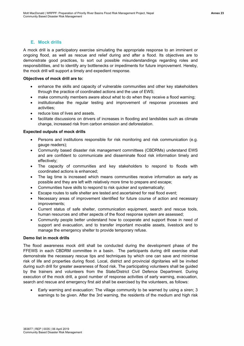
Mock drills: Another preparedness measure envisaged under the Local DRM Plans is to undertake regular mock drills, as a way to test preparedness and response systems at all levels and engage communities to better understand the overall early warning, preparedness and response systems. Further recommendations about the conduct of mock drills are described in Annex (E).
8 Further detail on this has been elaborated in the Feasibility Studies, which could be integrated here as needed. 9 A good example of the process for the development of early warning and hazard messages is found in Nepal Red Cross Society, British
Red Cross Society. Report on Participatory Campaign Planning (PCP) Process: How to design effective and inclusive hazard messages (2018)
Mott MacDonald | WRPPF: Preparation of Priority River Basins Flood Risk Management Project, Nepal 18Community Based Disaster Risk Management
383877 | REP | 0035 | 06 April 2019 Community Based Disaster Risk Management
Other measures: The project may support other priority small scale risk reduction measures identified in the CDRMPs and LDRMPs, in consultation with relevant stakeholders and where resources allow. This may include for example: collective food storage facilities, animal shelters and “safe houses” as alternative evacuation sites and school education programs.
3.6 Component 2: Community-based DRM capacity building This component aims to directly engage communities in understanding and managing the risks they face through enhancing community decision-making and resource mobilisation. It also encourages community participation in municipality-level DRM planning, to foster strong institutional linkages between the two levels and support the sustainability of the CDRMCs.
3.6.1 Establishment of community disaster risk management committees (CDRMC)
Rationale
Establishment of CDRMCs is an opportunity to engage whole communities in the DRM process through the selection of representatives and the pooling of collective funds. The formality of the process and the preparation of detailed TORs are important for building the trust and confidence in the integrity of the committee, particularly where households are being asked to make a contribution to pooled funds. The participation of women and people from marginalised groups on the committees is an important opportunity for social empowerment and to improve their overall standing within the community. The establishment of a physical structure for the CDMCs also enhances the profile and visibility of the CDMC and serves as an important asset for income generation as well provide additional community space.
Process
60 CDRMCs should be established, comprising the ten target communities from each of the six basin to make planning and resource allocation decisions for community-based DRM activities.
Terms of Reference (TORs) for CDRMCs should be drafted, setting out the purpose, structure, responsibilities and term of CDRMCs. The TORs may be revisited by each of the CDRMCs, once established, and tailored to their particular circumstances. Suggested content for the TOR is described in Annex G.
Each selected community should nominate and, if needed, vote for representatives for the CDRMC. Communities could be divided into representatives of clusters of households if the population size is large, or if this ensures that people from marginalised groups can be better represented.
CDRMCs should comprise approximately 15 members (an odd number to avoid potential voting deadlocks), depending on community size, of which at least 60% should be women, including at least two office bearer positions.
CDRMCs should be formally recognised/represented on LDRMCs wherever possible.
CDRMCs should include other groups e.g. Water user group and Community forestry user group; LDRMPs should also include a plan for reducing risk, mainly from carbon emission, deforestation and drying out of water ponds.
The CDRMCs should encourage and manage community contributions for pooled funds as well as contributions from other sources.
Mott MacDonald | WRPPF: Preparation of Priority River Basins Flood Risk Management Project, Nepal 19Community Based Disaster Risk Management
383877 | REP | 0035 | 06 April 2019 Community Based Disaster Risk Management
The CDRMCs should also be responsible for the establishment and management of Community Disaster Response Teams (CDRTs) (see further below).
Wherever possible the CDMCs should arrange for the design and construction of their own multi-purpose community building which could serve a meeting space for the CDMC, operational and training space for the CDRTs, storage of response equipment, rental as community meeting space (as part of income generation) and possibly as an evacuation shelter if needed.
CDRMCs should also implement a feedback mechanism from communities to record, monitor and address complaints. This should be through a variety of channels relevant to each community, such as message boxes, SMS, phone and in-person communication with CDRMC members, community mobilisers and others.
3.6.2 Development of Community DRM Plans (CDRMP)
Rationale
CDRMPs are the foundation of community-based DRM interventions. Through a consultative process, they identify the highest priority risks and hazards facing each community and use a combination of local and traditional knowledge and national / international best practice to mitigate and better prepare for disasters. The process for developing CDRMPs is important for encouraging households to become more aware about the risks and hazards in their communities and to jointly contribute to identifying solutions and strategies, giving the plans the greatest chance of success.
Process
CDRMCs should lead the process of developing CDRMPs, with technical support and input from other agencies and LDRMCs as required.
The plan should be based on multi-hazard Vulnerability and Capacity Assessments (VCAs) conducted with the community10
The plans should span 3-5 years and include: o Small scale livelihood mitigation measures implemented at community or household
level o Role of Community Disaster Response Teams (see further below) o Reference to the Local DRM Plan, in particular with regard to roles and
responsibilities, early warning and evacuation measures. o Timeframes and resource allocation
The CDRMP programmes should be aligned as much as possible with local development planning processes.
3.6.3 Establishment of Community Disaster Response Teams (CDRT)
Rationale
The purpose of CDRTs is to establish a cadre of trained community volunteers to provide immediate rapid response to emerging hazards and disasters, complementary to other response mechanisms at ward and municipality level. Some key considerations to ensure the longevity and effectiveness of CDRTs include the need to recruit adequate numbers of volunteers on an ongoing basis to ensure sufficient stand-by capacity at all times of the year
10 A good example is provided in Nepal Red Cross Society, British Red Cross Society. Strengthening Urban Resilience and Engagement
Mott MacDonald | WRPPF: Preparation of Priority River Basins Flood Risk Management Project, Nepal 20Community Based Disaster Risk Management
383877 | REP | 0035 | 06 April 2019 Community Based Disaster Risk Management
and rostering and incentive schemes to ensure that volunteer time does not conflict with or compromise livelihood activities.
Process
CDRTs should be established by the CDRMCs through the development of TORs which include roles/responsibilities, recruitment, training, deployment management, incentives and recognition, equipment and resourcing and linkages to existing response functions at ward and municipality level.
The CDRTs should include volunteers trained in the following core activities: o Early warning and risk communication o First aid, search & rescue o Evacuation shelter management and relief distribution
CDRTs should comprise 20-30 volunteers, of which at least 50% should be women, with the possibility to form some all-women teams if deemed appropriate for the community context.
3.6.4 Small scale mitigation measures and livelihood support
Rationale
The implementation of small scale mitigation measures and livelihood support is an important way for the CDRMCs to demonstrate their relevance and gain the support and trust of their community, particularly in the early stages of development. These activities should be undertaken based on the priorities identified in the LDRMPs, through a transparent process involving the discussion and development of criteria for identifying the most vulnerable households in need of additional support. The provision of livelihood support should ideally be targeted towards women and women-headed households, recognising that increasing women’s control over financial resources can significantly improve their household and community status, improve their health and safety and help address other social disadvantages.
Process
Risk mitigation measures: These should be identified through community Vulnerability and Capacity Assessments, including locations of highest risk from which to select beneficiary households. Examples of measures include: household plinth raising, raising latrine and tube well platforms and other means of accessing / protecting water sources during floods, household measures to protect personal belonging & assets during times of flood. Measures should ideally be implemented by the households themselves, with appropriate financial assistance and technical support to ensure that quality and safety standards are being met.
Livelihood support: Types of livelihood support should be identified through the community Vulnerability and Capacity Assessments with supplementary agriculture and market analysis. Some support may be focussed on adaptation of existing livelihoods to better withstand current and predicted hazard patterns, such as more resilient crop, changing livestock or livestock practices and provision of training on efficient farming and crop management. Other support may be targeted to livelihood diversification for women, the ultra-poor and other disadvantaged groups, which may look at alternative sources of income such as market gardening, animal husbandry, tailoring, shop keeping, mechanical and repair services).
Mott MacDonald | WRPPF: Preparation of Priority River Basins Flood Risk Management Project, Nepal 21Community Based Disaster Risk Management
383877 | REP | 0035 | 06 April 2019 Community Based Disaster Risk Management
4 Management and implementation
4.1 Management and implementation structure11 The management of this project falls under the overall management structure of the ‘Priority River Basins Flood Risk Management Project’, which comprises the following:
Executing Agency: Ministry of Energy, Water Resource and Irrigation (MoEWRI) Implementing Agency: Department of Water Resource and Irrigation (DoWRI) Project Management: Project Management and Implementation Consultant Team
(PMIC)
CBDRM project management and implementation:
Specifically, for the management of these CBDRM components, the following structure is recommended:
Steering Committee: Comprising ADB and the MoEWRI, DoWRI and other relevant ministries and departments, including but not limited to MoFAGA, MoHA, MoUD and DHM to provide overall guidance and policy support to the various aspects of this project and to ensure collaboration with counterparts at provincial and municipality level.
Basin Coordination Committees: For each basin comprising the municipal representatives, of MoEWRI, DoWRI and other relevant ministries and departments as available, including but not limited to MoFAGA, MoHA, MoUD and DHM. These committees provide guidance and policy support for this project and the relevant agencies have direct responsibilities for implementation of some aspects of this project.
Project Management and Implementation Consultant Team (PMIC): Overall management support and oversight of the activities of the local NGO/CBO as well as technical support to relevant ministries/departments through FFEWS & Preparedness Infrastructure and CBDRM experts. Content for the TOR is included in Annex H.
Local NGO/CBO(s): One or more local NGOs or CBOs (may differ between target locations) to provide management support and oversight of the CDRMCs, undertake community mobilisation, resilience surveys, provide technical training and support for CDRTs and small-scale mitigation and livelihood activities. Content for the TOR should be developed by the CBDRM Expert.
4.2 Estimated timeline The following provides a broad outline of timeframes required for the different project components, assuming a total implementation time of 5 years.
11 ADB and consultant to provide further guidance on management/implementation structures.
Mott MacDonald | WRPPF: Preparation of Priority River Basins Flood Risk Management Project, Nepal 22Community Based Disaster Risk Management
383877 | REP | 0035 | 06 April 2019 Community Based Disaster Risk Management
Mid-term review (mid-line resilience survey, project evaluation and monitoring)
Exit phase (end-line review, project evaluation)
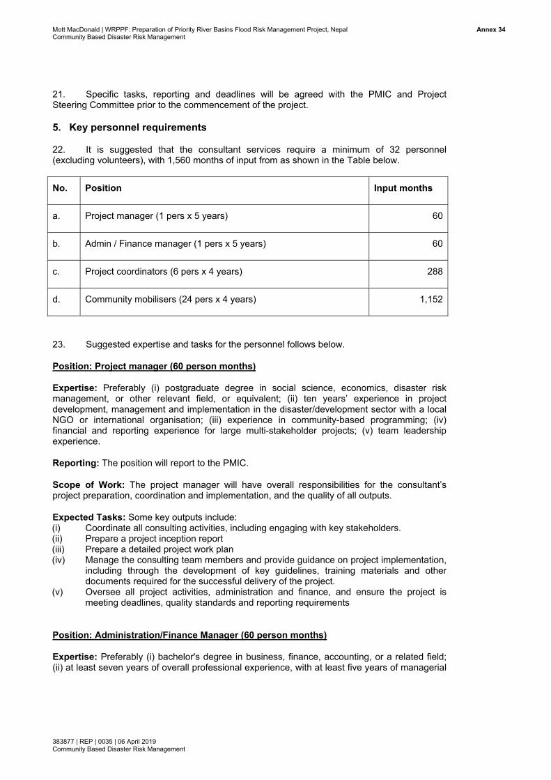
4.3 Budget considerations12 Consulting firm:
1 x FFEWS expert (national or international) 1 x CBDRM expert (national or international) (other management costs included in wider project)
NGO/CBO:
1 x Project manager 1 x Admin/Finance Manager 6 x Coordinators (1 per basin) 24 x Community Mobilisers (2 male & 2 female per basin) Costs of baseline, mid-line and end-line surveys (60 communities) 12 The full budget will need to be developed by the consultants, the below are some notes which may be helpful for this process
Mott MacDonald | WRPPF: Preparation of Priority River Basins Flood Risk Management Project, Nepal 23Community Based Disaster Risk Management
383877 | REP | 0035 | 06 April 2019 Community Based Disaster Risk Management
Office and admin costs in each basin
LDMCs:
[N] x LDMC trainings and orientations for members Supplementary operation costs if needed.
Preparedness and mitigation works:
Flood Forecasting System (see budget in feasibility studies) Evacuation shelters (see budget in feasibility studies) Other mitigation works (to be determined by each LDMC
CDRMCs:
60 x CDRT member training and orientation 60 x CDRMC multi-purpose community buildings 60 x CDRT volunteer training & mobilisation incentives 60 x CDRT response visibility materials and equipment 60 x Seed funding for mitigation and livelihood activities Operational costs
Mid-term and end-term evaluations:
Independent consulting team 12 weeks: 1 week per basin x 2 evaluations
Note: Members of CDRMCs and NGOs should be trained at the beginning of the project in order to ensure a common methodology and understanding.
Mott MacDonald | WRPPF: Preparation of Priority River Basins Flood Risk Management Project, Nepal Annex 1Community Based Disaster Risk Management
383877 | REP | 0035 | 06 April 2019 Community Based Disaster Risk Management
Annexes
A. List of references
[1] P. Byem M. Horner. Easter 1998 Floods Vol. I: Report by the Independent Review Team to the Board of the Environment Agency (UK) (1998)
[2] Care Nepal. Study Report on Local Disaster Risk Management Plan and Participatory Vulnerability Capacity Assessment of Community Support Program (CSP)-II (2014)
[4] S. Gaire, R.C Delgado, P.A González. Disaster risk profile and existing legal framework of Nepal: floods and landslides, Risk Management and Healthcare Policy, Dove Press (3 September 2013)
[5] Gautam D K (DIPECHO Newsletter) (2010), Community based flood early warning system in Nepal, DIPECHO Newsletter, Issue 9, July 2010
[6] Government of Nepal. Local Disaster Risk Management Planning Guideline (LDRMP) (2011)
[7] Government of Nepal. Guidelines for Formulation of District Disaster Management Plan, Ministry of Federal Affairs and Local Development (English translation) (2014)
[8] Government of Nepal, SAFER Nepal. Combined Training Report on District Early Warning System Experts (DEWS) followed by National Collaboration and Coordination (NCCII) Workshop-II (2014)
[9] Government of Nepal. Constitution of Nepal 2015 (English translation by Nepal Law Commission) (2015)
[10] Government of Nepal. Disaster Risk Reduction and Management Act 2017 (Act 45, 2017)
[11] Government of Nepal. National Strategic Action Plan for Disaster Risk Reduction and Management 2018 (2018)
[12] K. Hameed, Gender Issues in Livelihood and Flood Disaster: Case studies of Kamra and Kort Murad villages, Jhang District, Punjab, Journalist Resource Centre (JRC) (2001)
[13] Helvetas Nepal. Presentation on Local Governments Operation Act and It’s Implications (2017)
Mott MacDonald | WRPPF: Preparation of Priority River Basins Flood Risk Management Project, Nepal Annex 2Community Based Disaster Risk Management
383877 | REP | 0035 | 06 April 2019 Community Based Disaster Risk Management
[14] ICIMOD, SIDA. Role of Policy and Institutions in Local Adaptation to Climate Change: Case studies on responses to too much and loo little water in the Hindu Kush Himalayas (2012)
[15] ICIMOD. Community Based Flood Early Warning System for the Hindu Kush Himalaya (2016)
[16] Mercy Corps. Community Based Early Warning Systems in South and South East Asia (2012)
[17] Mercy Corps. Early Warning in Nepal: The Mercy Corps Experience 2008-2013 (2012)
[18] Mercy Corps. Testing the Added Value of Market Incentives on Disaster Risk Reduction in Western Nepal (2018)
[19] S. Moss. Local Voices, Global Choices for Successful Disaster Risk Reduction (undated – 2009?)
[20] Nepal Risk Reduction Consortium, Durham University, Foundation for Development Management. Final Report: Review of the Nine Minimum Characteristics of a Disaster Resilient Community in Nepal (2017)
[22] Nepal Red Cross Society, British Red Cross Society. Strengthening Urban Resilience & Engagement (SURE): Summary of Urban Assessment Results (2017)
[23] Nepal Red Cross Society, British Red Cross Society. Strengthening Urban Resilience and Engagement (“SURE”) Programme: Urban Assessment (VCA) Tools (2017)
[24] Nepal Red Cross Society, British Red Cross Society. Report on Participatory Campaign Planning (PCP) Process: How to design effective and inclusive hazard messages (2018)
[25] Plan Nepal. Child-Centered Disaster Risk Reduction: Project Evaluation and Learning (2012)
[26] Practical Action (2016), Mock Flood Exercises in Communities, Utilising Community-based Early Warning Systems
[27] Practical Action. Scaling Up Early Warning Systems in Nepal: Case Studies and Good Practices (2010)
[28] Practical Action. A Cost-Benefit Analysis of Practical Action’s Livelihood-Centered Disaster Risk Reduction Project in Nepal (2011)
[29] Practical Action. Strengthening Livelihood Capacities to Disaster Risk Reduction in Nepal (2011)
Mott MacDonald | WRPPF: Preparation of Priority River Basins Flood Risk Management Project, Nepal Annex 3Community Based Disaster Risk Management
383877 | REP | 0035 | 06 April 2019 Community Based Disaster Risk Management
[30] Practical Action. Mock Flood Exercises in Communities: Utilising Community-Based Early Warning Systems (2016)
[31] Scott, Dr M. Chhetri, Dr R Suwal et al. Independent Evaluation of the Integration of Disaster Resilience in DFID funded Programmes in Nepal, Final Report (2013)
[32] Thapa K., G.B. Sharma, R.B. Rana, K. Lamsal, and S. Subedi. Exploring climate adaptive mechanisms on watershed management, Local Initiatives for Biodiversity, Research and Development (LI-BIRD) (2011)
[33] UNDP. Country Report: Climate Risk Management for Agriculture in Nepal (2013)
[34] UNDP. List of Government of Nepal documents on disaster risk management (2014)
Mott MacDonald | WRPPF: Preparation of Priority River Basins Flood Risk Management Project, Nepal Annex 4Community Based Disaster Risk Management
383877 | REP | 0035 | 06 April 2019 Community Based Disaster Risk Management
B. Forecasting tool and proposed flood warning points A suite of flood forecasting modelling tools (see Table B.1) shall be made available through a FFEWS model development program in each basin. The models will be developed by consultants in direct participation from DHM. The operational models will be handed over to DHM, who will be responsible for routine operation of the forecast models and routine issue of forecast during monsoon.
This ranges from simple to highly advanced tools. The simplest tool could be operational as early as month 8, once hydrometric data becomes available from the proposed gauging network. Over a period of three years, the advanced hydraulic models will be developed, calibrated, validated and will be made operational, as more data becomes available from the new gauging network. The following forecasting tools have been proposed:
Gauge-to-gauge correlation: simplest and cheapest method, fast to develop, and thus could be operational soon; however, have very small lead time and also not appropriate in upper steep slope river reaches, and have other limitations;
Combined rainfall-runoff and gauge to gauge correlation: due to addition of runoff model, the forecast lead time could be up to 72hrs; however, this requires stage-discharge rating curve at each gauging station; such rating curve is difficult to develop for out of bank flow condition without a hydraulic model;
1-d model: this tool will be developed for the entire river system in each sub-project basin, and is appropriate for flood forecasting;
1-d/2-d linked model: This is the advanced forecast model, as used for example in Australia and the UK. This will be developed by month 24.
Rationale for different forecasting approaches
The four approaches, described above, are inter-linked and essential components to the final 1d/2d linked FFEWS model. The rationale for each approach, its advantages and disadvantages are described below:
Gauge-to-gauge correlation: the simplest and cheapest method. It is an integral part of data analysis as the tool will provide support to the other four components, and thus, could be an option to use as a QUICK forecasting tool. It can generate new knowledge which can be translated into the final deliverables (1-d model and 1-d/2-d linked model). Advantages will be that CBDRM could be operational earlier and potential areas of uncertainty in flood level forecast could be identified. DHM is using this method in many of their river basins, e.g. in Karnali. This tool and expertise from DHM could readily be used in this basin with nominal input of the international consultant who developed this tool. Thus, a minimum budget has been proposed for developing this tool. If ADB and DoWRI prefer, this component could be dropped. However, there will be a waiting time in all six basins for the new hydro-meteorological data to become available, so this work is a good utilisation of the waiting time as it generates the opportunity for transferring early knowledge to the final product.
Rainfall run-off model is the main input to all other components: a) gauge-to-gauge correlation, b) 1-d river model, c) pure 2-d model and d) 1-d/2-d linked model. Combining the rainfall model with gauge-to-gauge correlation will increase the lead time (as in the rainfall forecast) up to 24, 48 and 72 hours. However, at the forecasting points, the discharge vs water level rating curve shall be required so that forecasted runoff can be converted to the water level using the rating curve. The rainfall runoff model provides inflows from the upper catchment and distributed inflows from intermediate catchments to the 1-d, 2-d and 1-d/2-d linked model.
Mott MacDonald | WRPPF: Preparation of Priority River Basins Flood Risk Management Project, Nepal Annex 5Community Based Disaster Risk Management
383877 | REP | 0035 | 06 April 2019 Community Based Disaster Risk Management
1d model, as a standalone tool, can be applied as a forecasting tool once it is ready;
without the 1-d model, a linked 1-d/2-d model (which is proposed as a final deliverable) cannot be developed. Therefore, it is suggested to employ a 1-d model as forecasting tool as soon as it is ready. In any case, for certain reaches of the river, there will only be a 1-d model, as a 1-d/2-d linked model is not feasible to be developed for the entire reach of the river. This tool will also give useful feedback on forecasting performance, which then could be translated into the final deliverable. In summary, 1-d model development is not a duplicating tool; it is an essential pre-requisite. Should DoWRI and ADB decide not to take forward 1-d/2-d linked modelling, then a 1-d model will be the final product. This is the tool which DHM operate in the Bagmati, Koshi and West Rapti basins. The advantage of a 1-d model is that it runs efficiently, which is a key requirement for real time forecasting. However, a 1-d model does not have direct map output for flood risk or hazard these would require separate and customised GIS development, e.g. as practiced by forecast model in Bangladesh (http://ffwc.gov.bd/). Such a GIS tool is under development within DHM. It will need to be developed in this project for the 1-d only model reaches of the river.
1d/2d linked model is the final deliverable; such FFEWS models are already in operation in countries like Australia, New Zealand and UK (Syme, 2007; Huxley, 2016). Therefore, developing the next generation of the FFEWS tool would ensure that by the time the project is complete, Nepal won’t fall behind on national standards. The 1-d/2-d linked model can forecast flood levels with better accuracy (as it is linked to 2-d floodplain model); flood risk and hazard maps are direct outputs from such modelling. However, run-time is longer than for the 1-d model; it requires more accurate DEM and it is not feasible to develop it for all reaches of the river. For selected river reaches, where such modelling will be useful, like in the Lower Terai, this tool shall be developed. To overcome run-time issues for real time forecasting, GPU (graphical processing unit) or HPC (heavily parallelised computing) versions of modelling software shall be used.
Table B.1 Forecasting tool to be developed in all five basins (in West Rapti basin, a separate FFEWS being developed by DHM)
Forecasting tool Forecasted output Lead time (hour)
When available for operation
Gauge to gauge correlation
Flood/Water level 3 to 5 On 12th month during implementation phase
Combined rainfall-runoff and Gauge to gauge correlation
Flood/Water level 24, 48 and 72 On 18th month during implementation phase
1-d model Flood/Water level and flood map
24, 48 and 72 On 24th month during implementation phase
1d and 1-d/2-d linked model
Flood/Water level and flood map
24, 48 and 72 On 30th month during implementation phase
Source: Mott MacDonald
Forecast dissemination
DHIM’s existing forecast dissemination system will be used (Figure B.1). DHM disseminates flood forecast and early warning from national level, from where the flood warning is communicated to the community level. The flow of information is shown in Figure B.1. DHM
Mott MacDonaldCommunity Base
383877 | REP | 0Community Base
disseminateEmergency Centers (Dcommittees
Figure B.1:
Source: DHM
| WRPPF: Prepaed Disaster Risk M
0035 | 06 April 20ed Disaster Risk M
es the forecaOperation
DEOC). DEOs to the local
: Flood forec
M (Courtesy Mr
ration of Priority RManagement
19 Management
ast to DHM Centers, wh
OC then discommunity.
casting diss
Binod Parajuli,
River Basins Flood
basin officeho transmits sseminates
semination s
Hydrologist/For
d Risk Manageme
es and to NEthe forecas
the forecas
system with
recaster, Flood
ent Project, Nepal
EOC. NEOCst to Districtst to media
hin DHM
Forecasting Se
C then informt Emergency
and throug
ction)
m Provincial y Operation gh different
Annexx 6
Mott MacDonaldCommunity Base
383877 | REP | 0Community Base
Mohana-Kh
The final fonumerous fTotal modeforecasting minimum evshall be at compared tapproximateshown in Fi
Figure B.2(additional the model d
Source: Mott
| WRPPF: Prepaed Disaster Risk M
0035 | 06 April 20ed Disaster Risk M
hutiya basin
orecasting toflood warningelled river len
tool has bevery 500m agauged stato real time oely at everygure B.2.
: Proposed warning po
domain)
t MacDonald
ration of Priority RManagement
19 Management
n
ool shall be g points alongth shall beeen designeapart along tions, and th
observed daty 16km lengt
flood warnoints could b
River Basins Flood
an advanceng the lengte approxima
ed so that fohe course ofus the forecta as the moth. Proposed
ning points be generate
d Risk Manageme
ed 1d/2d linkth of the riveately 131km orecasted wf the river. A
casted water odel shall be d flood warn
at gauged ed anywhere
ent Project, Nepal
ked model, er to guide t(within 1d a
water levels Among them
level is expcalibrated (a
ning points
station in Me to the need
and thus, ththe CBDRM and 1d/2d doshall be ava, nine forecaected to be against the gat gauged s
Mohana-Khud of commu
here will be volunteers.
omain). The ailable at a asted points satisfactory
gauge data) stations are
utiya basinunity within
Annexx 7
Mott MacDonaldCommunity Base
383877 | REP | 0Community Base
Mawa-Ratu
The final fonumerous fTotal modeforecasting minimum evshall be at compared tapproximateshown in Fi
Figure B.3(additional the model d
Source: Mott
| WRPPF: Prepaed Disaster Risk M
0035 | 06 April 20ed Disaster Risk M
uwa basin
orecasting toflood warningelled river len
tool has bevery 500m agauged stato real time oely at everygure B.3.
3: Proposedwarning po
domain)
t MacDonald
ration of Priority RManagement
19 Management
ool shall be g points alongth shall beeen designeapart along tions, and th
observed daty 15km lengt
d flood waroints could b
River Basins Flood
an advanceng the lengte approximaed so that fthe course ous the forecta as the moth. Proposed
rning pointsbe generate
d Risk Manageme
ed 1d/2d linkth of the riveately 112km forecasted wof the river. Acasted water odel shall be d flood warn
s at gaugeded anywhere
ent Project, Nepal
ked model, er to guide t(within 1d a
water level sAmong themlevel is expcalibrated (a
ning points
d station ine to the need
and thus, ththe CBDRM and 1d/2d doshall be ava
m four forecaected to be against the gat gauged s
n Mawa-Ratd of commu
here will be volunteers.
omain). The ailable at a asted points satisfactory
gauge data) stations are
tuwa basinunity within
Annexx 8
Mott MacDonaldCommunity Base
383877 | REP | 0Community Base
Bakraha ba
The final fonumerous fTotal modeforecasting minimum evshall be at compared tapproximateshown in Fi
Figure B.4:warning podomain)
Source: Mott
| WRPPF: Prepaed Disaster Risk M
0035 | 06 April 20ed Disaster Risk M
asin
orecasting toflood warningelled river len
tool has bevery 500m agauged stato real time oely at everygure B.4.
: Proposed foints could
t MacDonald
ration of Priority RManagement
19 Management
ool shall be g points alongth shall been designeapart along tions, and th
observed daty 12km lengt
flood warnibe generate
River Basins Flood
an advanceng the lengte approxima
ed so that fthe course ous the forecta as the moth. Proposed
ng points ated anywhere
d Risk Manageme
ed 1d/2d linkth of the riveately 74km (forecasted wof the river. casted water odel shall be d flood warn
t gauged stae to the nee
ent Project, Nepal
ked model, er to guide t(within 1d awater level sAmong themlevel is expcalibrated (a
ning points
ation in Baked of commu
and thus, ththe CBDRM nd 1d/2d doshall be avam five forecaected to be against the gat gauged s
kraha basin unity within
here will be volunteers.
omain). The ailable at a asted points satisfactory
gauge data) stations are
(additional n the model
Annexx 9
Mott MacDonaldCommunity Base
383877 | REP | 0Community Base
Lakhandei
The final fonumerous fTotal modeforecasting minimum evshall be at compared tapproximatein Figure B.
Figure B.5(additional the model d
Source: Mott
| WRPPF: Prepaed Disaster Risk M
0035 | 06 April 20ed Disaster Risk M
Basin
orecasting toflood warningelled river len
tool has bevery 500m agauged stato real time oely at very 95.
5: Proposedwarning po
domain)
t MacDonald
ration of Priority RManagement
19 Management
ool shall be g points alongth shall been designeapart along tions, and th
observed datkm length. P
d flood waoints could b
River Basins Flood
an advanceng the lengte approxima
ed so that fthe course ous the forecta as the mo
Proposed floo
arning poinbe generate
d Risk Manageme
ed 1d/2d linkth of the riveately 61km (forecasted wof the river. Acasted water odel shall be od warning p
nts at gauged anywhere
ent Project, Nepal
ked model, er to guide t(within 1d awater level sAmong themlevel is expcalibrated (a
points at gau
ged statione to the need
and thus, ththe CBDRM nd 1d/2d doshall be ava
m four forecaected to be against the g
uged stations
in Lakhand of commu
here will be volunteers.
omain). The ailable at a asted points satisfactory
gauge data) s are shown
ndei basinunity within
Annex 10
Mott MacDonaldCommunity Base
383877 | REP | 0Community Base
East Rapti
The final fonumerous fTotal modeforecasting minimum evshall be at compared tapproximateshown in Fi
Figure B.6(additional the model d
Source: Mott
| WRPPF: Prepaed Disaster Risk M
0035 | 06 April 20ed Disaster Risk M
Basin
orecasting toflood warningelled river len
tool has bevery 500m agauged stato real time oely at everygure B.6.
6: Proposedwarning po
domain)
t MacDonald
ration of Priority RManagement
19 Management
ool shall be g points alongth shall beeen designeapart along ions, and th
observed daty 14km lengt
d flood waoints could b
River Basins Flood
an advanceng the lengte approximaed so that fthe course ous the forecta as the moth. Proposed
arning pointbe generate
d Risk Manageme
ed 1d/2d linkth of the riveately 139km forecasted wof the river.
casted water odel shall be d flood warn
ts at gauged anywhere
ent Project, Nepal
ked model, er to guide t(within 1d a
water level sAmong themlevel is expcalibrated (a
ning points
ged station e to the need
and thus, ththe CBDRM and 1d/2d doshall be avam six forecaected to be against the gat gauged s
in East Rd of commu
here will be volunteers.
omain). The ailable at a asted points satisfactory
gauge data) stations are
Rapti basinunity within
Annex 11
Mott MacDonaldCommunity Base
383877 | REP | 0Community Base
C. GSFEWS will Mobile comtechnology providers incompanies providers hmeteorologibased on tgorges do nNepal is shinstallation,
Figure C.1
Source: DHM
| WRPPF: Prepaed Disaster Risk M
0035 | 06 April 20ed Disaster Risk M
SM coveragprimarily us
mmunication has been u
n Nepal. Nceare providing
have severaical stations he line of-sinot have comown in Figuand if neede
GSM covera
M, 2018
ration of Priority RManagement
19 Management
ge se the code
(GSM) techused by NTCll is one of thg services to
al gaps in tcannot transght commun
mmunication re C.1. For aed, station lo
age (top) an
River Basins Flood
-division muhnologies toC while the he companieo DHM for retheir networsmit data on nication, someven within any new mo
ocation could
nd CDMA Ne
d Risk Manageme
ultiple acceso disseminatGSM techno
es with the laeal-time data rk coverage a real-time
me of the hythe area of t
onitoring stat be shifted in
epal Telecom
ent Project, Nepal
ss (CDMA) ate flood alerology is supargest GSM n
acquisition. . In these basis. Sinceydrometric stheir coveragtion, GSM mn consultatio
m Network (
and Global rt and warn
pported by onetworks in NHowever, thgap areas,
e these techntations locatge. The existust be checn with DHM.
(bottom)
System for ning. CDMA other mobile Nepal. Both
hese service the hydro-
nologies are ted in deep ting GSM in
cked prior to .
Annex 12
Mott MacDonald | WRPPF: Preparation of Priority River Basins Flood Risk Management Project, Nepal Annex 13Community Based Disaster Risk Management
383877 | REP | 0035 | 06 April 2019 Community Based Disaster Risk Management
D. Evacuation shelters Introduction
One of the key preparedness measures envisaged under the Local DRM Plans are evacuation shelters. The need for, number of and location of shelters will vary and should be determined through a process of consultation with local authorities and communities. To further guide this process, information based on previous projects involving flood evacuation shelters, possible types and locations are included. Based on flood risk maps from pre-feasibility and feasibility study and number of settlements/communities with the flood affected areas, preliminary numbers of flood shelters have been decided (Table D.1). Evacuation routes to the flood shelters in all the basins will be based on 2D model results (flood maps) and road network. Although East Rapti has large basin area, due to the presence of Chitwan Forest, and fewer number of settlements in the flood affected areas, the number of shelters per basin area is small compared to the other basins.
Table D.1: Basin-wise flood shelter numbers in five basins (shelter numbers and their locations are indicative)
Basin Basin area (km2) Number of flood shelters
Indicative construction budget (US $)
Mohana-Khutiya 702 13 455,000
Mawa-Ratuwa 413 11 385,000
Bakraha 437 3 105,000
Lakhandei 425 6 210,000
East Rapti 2963 5 175,000
West Rapti 6370 10 350,000
Source: Pre-feasibility study, 2016
Flood mound for cattle
Flood mound are needed as safe shelter for cattle during flood, and should be included in CDRMP. As this is not usual practice for DRM in Nepal, we recommend to include this in CDRMP/LDRMP. The locations and numbers should be finalised through consultation.
A mound should be approximately 1.5 to 2.0m higher than the floodplain elevation. The mound surface should have a slight slope (less than 4 %). Erosion could be minimised by sowing pastures on the top and sides. An approximate area of 100m2 could be developed as flood mound. This may give space to about 30 cattle (adult cattle and goats/sheep together). To raise the land to 1.5m above normal floodplain level, it will require about 142m3 of sand (25 trucks). The sourcing of sand as construction material is relatively easy as sand is generally available within a 5-6km range of a proposed flood mound.
Experience with evacuation shelters in Nepal
The NGO Practical Action was consulted on their experience with the development and effectiveness of evacuation shelters in Nepal. For a project in the Karnali river basin, Practical Action Nepal is constructing 12 flood shelters.
Mott MacDonald | WRPPF: Preparation of Priority River Basins Flood Risk Management Project, Nepal Annex 14Community Based Disaster Risk Management
383877 | REP | 0035 | 06 April 2019 Community Based Disaster Risk Management
Despite training and warnings, it is known that people will evacuate their houses always at the last possible moment. That would mean that flood shelters should be located close to the communities. Practical Action uses a rule of thumb of a 15-minute walk to the flood shelters, which is about 1km in distance.
There are no standard designs for flood shelters as the local conditions e.g. available land and number of people in a rural municipality (Gaunpalika, previously it was VDC), will influence the designs. These shelters are mainly for emergency support and are not to be used for longer periods. Shelters are used for a maximum of 3 days, but more often only a few hours. Basic requirements are that a flood shelter should have:
The ground floor should be constructed above the measured highest flood level. In practise, Practical Action designs the flood shelters about 1.2m (4 foot) above the ground level. A ramp will be constructed to allow disabled and elderly to access the ground floor easily.
Safety of people is important. As this is an emergency evacuation the people need to be safe at all times. This is required the structures, for example, to be earth quake resistant and have strong hand rails along the stairs and wider staircases so that elderly and disabled can receive support from others when going to the first floor.
Besides an open common area, the first floor of the shelter has at least 4 rooms: 1 x room with toilets for women; 1 x room with toilets for men; 1 x changing room; and 1 x storage room.
An example of a flood shelter is provided in Figure D.1. It is noted that flood shelters are only used during a short period of year. During the dry season the flood shelter can be used for other community activities such as training or community meetings. The shelter below constructed in 2015 costs approximately 25,000 – 30,000 USD. One flood shelter is used by 150 – 160 people, maximum 200 people.
Participatory approach
CBDRM necessarily includes a participatory approach and a flood resilience capacity assessment with the local communities. An inventory of the different houses and buildings in each community should be made to identify the vulnerable and non-vulnerable places. Available schools or government buildings, which are most of the time higher and stronger structures compared to houses, can be used for temporarily shelter during flood events. In case of the absence of those kind of buildings, flood shelters can be constructed. It is recognised that most communities do have some form of “safe house” (often a local school) identified, and the assessment process will need to review how appropriate the existing systems are.
In case flood shelters are required, it is important to discuss and decide together with the community where the flood shelter should be constructed. The location of the shelter will need to consider how safe it is (low/high ground), how far it is from those it is serving, and land ownership.
In other programmes, such as Practical Action in Karnali, there were no land acquisition costs for flood shelters. Their common practise has been that either the local government or a local private land owner voluntarily donated the land (approximately one katha is required, which is about 339m2). In the latter case, the land is legally transferred to community ownership through e.g. the forest groups or water users groups, which are legally registered groups. The CDMC is not a legally registered group and cannot have ownership.
72; nstruct houst the housesere living is drease the gra.
Evacuation
ctical Action Ne
ration of Priority RManagement
19 Management
what to do dmunities will f
lage level plaouses or otho ensure thaes would be
ing in such s are adaptedone on the ound floor a
shelters; Top
pal (bottom)
River Basins Flood
during emergfurther devel
anning to ideher important the structurthe DWIDM
way that thed to the locafirst floor wh
above the ex
p: Living on t
d Risk Manageme
gencies, CBlop and expa
entify “no gont building inres are locat
M flood zonin
ey are more al conditionshile the grounxisting groun
the first floor
ent Project, Nepal
BDRM shouldand. This sho
o” zones andnto flood-proted further awg as indicate
protected frs. Houses cand floor can d level base
r, above flood
d also look toould include:
d creating awne areas. Tway from theed in the DW
rom floods. Tan be e.g. bucope with flo
ed on the his
d level; Botto
o the future
wareness to This process e dangerous WIDM Policy
This means uilt on stilts, ooding or to storic floods
om: Flood
Annex 15
Mott MacDonald | WRPPF: Preparation of Priority River Basins Flood Risk Management Project, Nepal Annex 16Community Based Disaster Risk Management
383877 | REP | 0035 | 06 April 2019 Community Based Disaster Risk Management
During the CBDRM phase, it is important that together with the national and local government, the most vulnerable areas are identified. For these areas a detailed survey needs to be conducted to identify the vulnerable houses and those houses / buildings / structures that can be used for shelter. In Mohana-Khutiya there is already a well-functioning local network for flood response coordinated by the Red Cross, which receives up to date river flow information. This project needs to work at the local level to address areas where flood protection service provision needs reinforcement based on community priorities, and without duplication of the efforts and support provided by others.
A survey of the existing resources has not been undertaken as part of the project. As mentioned above, a local needs assessment is essentially a participatory process to create local ownership and resilience.
Mott MacDonaldCommunity Base
383877 | REP | 0Community Base
Mohana-Kh
Based on dfeasibility stselected. Th
Figure D.2:
Source: Mot
| WRPPF: Prepaed Disaster Risk M
0035 | 06 April 20ed Disaster Risk M
hutiya basin
density of rutudy (this sthe indicative
: Indicative
tt MacDonald
ration of Priority RManagement
19 Management
n
ural municipaudy), the pre locations ar
location of f
River Basins Flood
alities (earlieeliminary locre shown in F
flood shelte
d Risk Manageme
er known as cations of thFigure D.2.
ers Mohana
ent Project, Nepal
VDC), and he 13 nos flo
– Khutiya b
flood outlineood shelters
asin
es from the have been
Annex 17
Mott MacDonaldCommunity Base
383877 | REP | 0Community Base
Mawa-Ratu
Based on dfeasibility stselected (Fi
Figure D.3:
Source: Mott
| WRPPF: Prepaed Disaster Risk M
0035 | 06 April 20ed Disaster Risk M
uwa basin
density of rutudy (this stigure D.3).
: Indicative
t MacDonald
ration of Priority RManagement
19 Management
ural municipaudy), the pre
location of f
River Basins Flood
alities (earlieeliminary loc
flood shelte
d Risk Manageme
er known as cations of th
ers Mawa-Ra
ent Project, Nepal
VDC), and he 11 nos flo
atuwa basin
flood outlineood shelters
es from the have been
Annex 18
Mott MacDonaldCommunity Base
383877 | REP | 0Community Base
Bakraha ba
Based on dfeasibility sselected (Firural munici
Figure D.4:
Source: Mott
| WRPPF: Prepaed Disaster Risk M
0035 | 06 April 20ed Disaster Risk M
asin
density of rustudy (Packaigure D.4). Tipalities are o
: Indicative
t MacDonald
ration of Priority RManagement
19 Management
ural municipaage 3, 2016Three shelteroutside the 1
location of f
River Basins Flood
alities (earlie6), the prelirs have been00-year floo
Mott MacDonald | WRPPF: Preparation of Priority River Basins Flood Risk Management Project, Nepal Annex 23Community Based Disaster Risk Management
383877 | REP | 0035 | 06 April 2019 Community Based Disaster Risk Management
E. Mock drills A mock drill is a participatory exercise simulating the appropriate response to an imminent or ongoing flood, as well as rescue and relief during and after a flood. Its objectives are to demonstrate good practices, to sort out possible misunderstandings regarding roles and responsibilities, and to identify any bottlenecks or impediments for future improvement. Hereby, the mock drill will support a timely and expedient response.
Objectives of mock drill are to:
enhance the skills and capacity of vulnerable communities and other key stakeholders through the practice of coordinated actions and the use of EWS;
make community members aware about what to do when they receive a flood warning; institutionalise the regular testing and improvement of response processes and
activities; reduce loss of lives and assets. facilitate discussions on drivers of increases in flooding and landslides such as climate
change, increased risk from carbon emission and deforestation.
Expected outputs of mock drills
Persons and institutions responsible for risk monitoring and risk communication (e.g. gauge readers);
Community based disaster risk management committees (CBDRMs) understand EWS and are confident to communicate and disseminate flood risk information timely and effectively;
The capacity of communities and key stakeholders to respond to floods with coordinated actions is enhanced;
The lag time is increased which means communities receive information as early as possible and they are left with relatively more time to prepare and escape;
Communities have skills to respond to risk quicker and systematically; Escape routes to safe shelter are tested and ascertained for real flood event; Necessary areas of improvement identified for future course of action and necessary
improvements; Current status of safe shelter, communication equipment, search and rescue tools,
human resources and other aspects of the flood response system are assessed; Community people better understand how to cooperate and support those in need of
support and evacuation, and to transfer important movable assets, livestock and to manage the emergency shelter to provide temporary refuse.
Demo list in mock drills
The flood awareness mock drill shall be conducted during the development phase of the FFEWS in each CBDRM committee in a basin. The participants during drill exercise shall demonstrate the necessary rescue tips and techniques by which one can save and minimise risk of life and properties during flood. Local, district and provincial dignitaries will be invited during such drill for greater awareness of flood risk. The participating volunteers shall be guided by the trainers and volunteers from the State/District Civil Defence Department. During execution of the mock drill, a good number of response activities of early warning, evacuation, search and rescue and emergency first aid shall be exercised by the volunteers, as follows:
Early warning and evacuation: The village community to be warned by using a siren; 3 warnings to be given. After the 3rd warning, the residents of the medium and high risk
Mott MacDonald | WRPPF: Preparation of Priority River Basins Flood Risk Management Project, Nepal Annex 24Community Based Disaster Risk Management
383877 | REP | 0035 | 06 April 2019 Community Based Disaster Risk Management
zone of the village to be evacuated from their homes; risk zone maps must be well acquainted to the CBDRM committee and should be kept readily available for reference.
Rescuing groups of children, disabled and elderly along with livestock to be demonstrated. Pick-a-back method also to be applied to carry old and sick persons. Animal evacuation also to be conducted during the exercise.
Rescue of a drowning person: mock drill of rescuing a drowning person to be performed by the volunteers by using a long rope to pull him out of the water; to be safely carried accordingly to the first aid camp; first aid camp to be established by volunteers for a health check; victim to be covered by a blanket to warm up and kept in a relaxed position to avoid any serious problems related to respiration or circulation.
Use of sling: rescue of injured person slipping down the bank, carrying to the first aid camp and giving an arm sling, and advising to go to the nearby hospital for further medical advice and treatment.
Floating with the help of bottle-belt: demonstration of saving oneself by using a bottle belt, coconut-belt, with the help of a bamboo-pot floating aid.
Demonstration of giving CPR to a drowning casualty, carry to the first aid camp with the help of an improvised stretcher, e.g., made of bamboo and rope, and give CPR, but only after checking whether he needs CPR (Cardio Pulmonary Resuscitation) to recover from the critical condition.
Disposal of a casualty with free handed stretcher: A community person lost his consciousness and fell down beside the water body, which was later diagnosed as emotional shock. He was carried to the first aid camp by the volunteers by making a stretcher with their bare hands, as the other stretcher was used by another group in carrying casualty. In the camp, he was given first aid management to recover from his irregularity. After half an hour, he had recovered from the shock.
Use of rope stretcher to carry weaker individuals to the fist aid camp by a rope stretcher made for the purpose, give a glass of glucose water to regain strength, but only after confirming that he does not suffer from diabetes.
Dressing and bandaging: demonstration of dressing and bandaging to cut injury to stop bleeding and infection, and advising to go to nearby hospital for further medical treatment.
Some other activities to include in mock drill session splinting for broken bone, first aid management of snake bite, making and use of Oral Rehydration Solution (ORS), etc.
Mott MacDonald | WRPPF: Preparation of Priority River Basins Flood Risk Management Project, Nepal Annex 25Community Based Disaster Risk Management
383877 | REP | 0035 | 06 April 2019 Community Based Disaster Risk Management
F. Direct expenditures and training budget In the event of a flood and for routine communication of flood alerts, the volunteers will require specific equipment and communication devices and will also require training. Selection of equipment, communication devices, and need of training related to flood risk are based on experience in Nepal (Practical Action, 2016; Mercy Corps, 2008-13 and Gautam/DIPECHO Newsletter, 2010). The basin-wise budget of direct expenditures presented below are specific to flood risk management (the budget does not include any other direct expenditures of the multi-hazard risk components).
Direct expenditures considered for the volunteers and to offer them training, varied between basin to basin depending on the basin size (area); larger basins require more numbers of volunteers. Direct costs mainly include the following, see also Tables F.1 to F.6
Each volunteer (gauge reading and rescues operators) $10 per month for their top up of their mobile each year from 1 June to 31 October.
Each provided with raincoats, torches, boots, umbrellas, spare batteries for torches; price of the package approximately $70.
A mobile set, as a one-off offer; however, shall be replaced if damaged or lost, which has to be demonstrated; approximate price is $100.
The Village Disaster Management Committee (VDMCs) are equipped with certain tools and kits like a locally made motorized boat, Life jackets, Life buoys, Stretchers, Blankets, Sledge & Crow hammers, Ropes, Torch & Flash lights, Megaphones, Tents, Tirpals, Water storage tanks, First Aid box etc.
Mohana-Khutiya basin budget
Although 13 flood shelters have been proposed, 20 communities will be trained. It is expected that 7 communities have large buildings like schools and governmental buildings within their community and not need a flood shelter, only training.
Table F.1: Cost estimation CBDRM in Mohana-Khutiya basin [USD]
CBDRM Capital cost: yr 1
Operational cost, each year: yr2 to yr5
Communication equipment 77,800 54,460 Rescue material 18,600 13,020 Training from flood experts 54,000 18,000 Training from Civil Defence/H&S Expert 10,800 3,600 Total 161,200 89,080
Mawa-Ratuwa basin budget
Although 11 flood shelters have been proposed, 20 communities will be trained. It is expected that 9 communities have large buildings like schools and governmental buildings within their community and not need a flood shelter, only training.
Mott MacDonald | WRPPF: Preparation of Priority River Basins Flood Risk Management Project, Nepal Annex 26Community Based Disaster Risk Management
383877 | REP | 0035 | 06 April 2019 Community Based Disaster Risk Management
Table F.2: Cost estimation CBDRM in Mawa-Ratuwa basin [USD]
CBDRM Capital cost: yr 1 Operational cost, each year: yr2 to yr5
Communication equipment 77,800 54,460 Rescue material 18,600 13,020 Training from flood experts 54,000 18,000 Training from Civil Defence/H&S Expert 10,800 3,600 Total 161,200 89,080
Bakraha basin budget
Although 3 flood shelters have been proposed, 6 communities will be trained. It is expected that 3 communities have large buildings like schools and governmental buildings within their community and not need a flood shelter, only training.
Table F.3: Cost estimation CBDRM in Bakraha basin [USD]
CBDRM Capital cost: yr 1 Operational cost, each year: yr2 to yr5
Communication equipment 23,340 16,338 Rescue material 5,580 3,906 Training from flood experts 16,200 5,400 Training from Civil Defence/H&S Expert 3,240 1,080 Total 48,360 26,724
Lakhandei basin budget
Although 6 flood shelters have been proposed, 10 communities will be trained. It is expected that 4 communities have large buildings like schools and governmental buildings within their community and not need a flood shelter, only training.
Table F.4: Cost estimation CBDRM in Lakhandei basin
CBDRM Capital cost: yr 1 Operational cost, each year: yr2 to yr5
Communication equipment 38,900 27,230 Rescue material 9,300 6,510 Training from flood experts 27,000 9,000 Training from Civil Defence/H&S Expert 5,400 1,800 Total 80,600 44,540
East Rapti basin budget
Although 5 flood shelters have been proposed, 10 communities will be trained. It is expected that 5 communities have large buildings like schools and governmental buildings within their community and not need a flood shelter, only training.
Mott MacDonald | WRPPF: Preparation of Priority River Basins Flood Risk Management Project, Nepal Annex 27Community Based Disaster Risk Management
383877 | REP | 0035 | 06 April 2019 Community Based Disaster Risk Management
Table F.5: Cost estimation CBDRM in East Rapti basin
CBDRM Capital cost: yr 1
Operational cost, each year: yr2 to yr5
Communication equipment 38,900 27,230 Rescue material 9,300 6,510 Training from flood experts 27,000 9,000 Training from Civil Defence/H&S Expert 5,400 1,800 Total 80,600 44,540
West Rapti basin budget
There are 10 flood shelters proposed and 10 communities to be trained.
Table F.5: Cost estimation CBDRM in West Rapti basin
CBDRM Capital cost: yr 1
Operational cost, each year: yr2 to yr5
Communication equipment 38,900 27,230 Rescue material 9,300 6,510 Training from flood experts 27,000 9,000 Training from Civil Defence/H&S Expert 5,400 1,800 Total 80,600 44,540
Mott MacDonald | WRPPF: Preparation of Priority River Basins Flood Risk Management Project, Nepal Annex 28Community Based Disaster Risk Management
383877 | REP | 0035 | 06 April 2019 Community Based Disaster Risk Management
G. Terms of Reference for CDRMCs – suggested content Purpose: To improve the overall resilience of the community and mitigate the risks posed by hazards and disaster events.
Composition: The CDRMC shall comprise 15 representatives selected by the community, of which at least 60% (9 members) shall be women.
The members shall be selected on the basis of being able to undertake the required tasks of the committee and commit to the Code of Conduct required for all members.
The CDRMC, once established, shall elected from among its members the following office bearer positions, of which at least two shall be held by women:
o Chair o Secretary o Treasurer
Code of conduct: Each selected committee member shall be required to understand and commit to the Code of Conduct setting out basic principles of integrity, respect, protection of privacy, anti-corruption and other responsibilities associated with the role.
Roles and responsibilities: The roles and responsibilities of the CDRMC should include the following:
o Conducting community Vulnerability and Capacity Assessments (VCA) within the community to determine the priority hazards and risks facing the community and potential mitigation measures.
o Developing Community DRM Plans (CDRMP) based on the outcomes of the VCAs – see further below.
o Engaging with relevant LDRMCs, municipalities, local Nepal Red Cross Society chapters and other relevant agencies to share disaster risk, preparedness and response information.
o Ensuring that communities are informed in a timely manner about potential risks and hazards.
o Collecting and managing community DRM funds o for livelihood and small mitigation measures, (potentially managing/training
community preparedness & response teams), (potentially managing/training community volunteers for early warning)
Mott MacDonald | WRPPF: Preparation of Priority River Basins Flood Risk Management Project, Nepal Annex 29Community Based Disaster Risk Management
383877 | REP | 0035 | 06 April 2019 Community Based Disaster Risk Management
H. TOR for Project Implementation Consultant Team
Flood Forecasting and Early Warning System and Preparedness Infrastructure Expert (International): The Flood Forecasting and Early Warning System (FFEWS) & Preparedness Infrastructure Expert shall be responsible for the identification of specific FFEWS and preparedness infrastructure (evacuation shelters), stakeholder consultation, preparation of detailed implementation schedule, TOR, including training and works requirements, budget and RFP.
The training component should include a programme for developing awareness of CDMC members on the added future risk from climate change due to carbon emission, deforestation and thus increased risk on flooding and landslides. The expert’s responsibility shall also include identifying all affected municipalities in the priority river basins and preparing a summary of their institutional setup and how far they are in the transition to federalism.
The expert also explores and highlights government policies, plans and programmes linked to DRR in addition to the description on policy framework presented in this report (see Section 2 of this report). The expert will assist the PMU in obtaining ADB’s approval in all recruitment activities in accordance with the agreed procurement plan, government regulations and ADB’s requirements - issuing EOI and RFP, addendum/corrigendum and clarifications to firms’ queries, proposal opening, evaluation of EOI, and Technical and Financial proposals, preparation of relevant submissions/reports, obtaining ADB’s no-objection, awarding of contract and signing of contract. Prepare contract documentation.
The expert is required to undertake frequent field visits to works location spread across the widespread geographical areas of Terai and may require long walks, and therefore, the candidate should possess good health and be physically able to undertake such field visits. a. Qualifications Minimum: Post graduate degree in Civil Engineering/
Water resources/Hydraulics/Hydrology/Modelling-with 15 years of experiences
Preferable: Post-graduate degree in Disaster Risk Mitigation/Management, Development Planning or related field
b. Total professional experience 15 years minimum
c. Project-related experience Minimum 12 years of rich experience in flood forecasting/early warning systems, development planning, disaster control administration or related field.
Sound knowledge of ADB policies and procedures, and Disaster Management Act of Nepal will be an advantage.
Mott MacDonald | WRPPF: Preparation of Priority River Basins Flood Risk Management Project, Nepal Annex 30Community Based Disaster Risk Management
383877 | REP | 0035 | 06 April 2019 Community Based Disaster Risk Management
Community-Based Disaster Risk Management (CBDRM) Expert (National /International): The Community-Based Disaster Risk Management (CBDRM) Expert shall be responsible for identification of the need for CBDRM activities, stakeholder consultation, preparation of detailed implementation schedule, TOR, including training and small scale mitigation works and livelihood requirements. They will prepare the budget and RFP for the recruitment of one or more local NGOs/CBOs to implement CBDRM activities in accordance with the project proposal. Assist the PMU in obtaining ADB’s approval in all recruitment activities in accordance with the agreed procurement plan, government regulations and ADB’s requirements - issuing EOI and RFP, addendum/corrigendum and clarifications to firms’ queries, proposal opening, evaluation of EOI, and Technical and Financial proposals, preparation of relevant submissions/reports, obtaining ADB’s no-objection, awarding of contract and signing of contract. Prepare contract documentation. The expert is required to undertake frequent field visits to works location spread across the widespread geographical areas of Terai and may require long walks, and therefore, the candidate should possess good health and be physically able to undertake such field visits.
d. Qualifications Minimum: Graduate degree in community development, development/social studies, governance or other related field.
Preferable: Post-graduate degree in Disaster Risk Mitigation/Management, Development Planning or related field
e. Total professional experience 15 years minimum
f. Project-related experience Minimum 12 years of rich experience in community-based disaster risk mitigation/management, development planning, disaster control administration or related field.
Sound knowledge of ADB policies and procedures, and Disaster Management Act of Nepal will be an advantage.
Mott MacDonald | WRPPF: Preparation of Priority River Basins Flood Risk Management Project, Nepal Annex 31Community Based Disaster Risk Management
383877 | REP | 0035 | 06 April 2019 Community Based Disaster Risk Management
I. TOR for NGO/CBO Implementation Consultant
1. Background
1. Nepal is considered one of the most disaster-prone countries in the world. Alongside other natural hazards, such as earthquakes and landslides, flooding, river erosion, river shifting, and loss of lands pose a recurrent risk to large sections of the population. The Terai region of Nepal has approximately 17% of the country’s total area and has a population of 50.3% of country’s total population (CBS, 2012 and www.kullabs.com) and agriculture in the Terai region is the basis of the economy in Nepal. Flooding and erosion is particularly significant in the Terai has a major impact on communities, livelihoods, agriculture and development.
2. Acknowledging the importance of the Terai region to Nepal, the Government of Nepal (GoN), through the Ministry of Irrigation (MoEWR), is implementing the ‘Priority River Basins Flood Risk Management Project’ in the Southern Nepal Terai region. The project is the continuation of the pre-feasibility study: Package 3: Flood Hazard Mapping and Risk Management Project (DoWRI, 2016), which has identified 6 priority basins for the project: were selected and included in the cost-benefit analysis: i) West Rapti, ii) Mawa –Ratuwa, iii) Lakhandehi, iv) Mohana -Khutiya, v) East Rapt, vi) Bakraha.
3. The interventions in the sub-projects are designed to (i) reduce the incidence of severe floods; (ii) protect resident houses and public infrastructure, particularly in urban areas and market centers in the basins, from severe floods; (iii) protect agricultural land by reducing bank scouring and soil erosion, (iv) reduce the loss of life and injuries by implementing community-based disaster risk management (CBDRM) project to be operational in the above six basins over a period of 5 years, including an advanced flood forecasting and early warning system (FFEWS).
2. Project Scope
4. The CBDRM project (the Project) has been developed within the context of the legal and policy framework of the GoN and taking into account national best practices and lessons learned from the country’s extensive experience in CBDRM over many years. The full details of the project are included in the CDBRM project design document.
5. Purpose: to compliment the structural components of the ‘Priority River Basins Flood Risk Management Project’. Through a participatory, community-based approach, this project aims to: (i) reduce the loss of life, household and community assets, property and livelihoods from flood-related and other disasters; and (ii) strengthen community resilience and a create safer environment for economic and social development.
6. Component 1 Institutional DRM capacity building: focusses on strengthening capacities for DRM at municipality level, which will provide an important framework for supporting community-based DRM initiatives. It involves the establishment of institutional structures and plans, as well as the establishment of early warning systems and structural and non-structural preparedness measures.
7. Component 2 Community-based DRM capacity building: directly engages communities in understanding and managing the risks they face through enhancing community decision-making and resource mobilisation. It also encourages community participation in municipality-level DRM planning, to foster strong institutional linkages between the two levels and support the sustainability of the CDRMCs.
Mott MacDonald | WRPPF: Preparation of Priority River Basins Flood Risk Management Project, Nepal Annex 32Community Based Disaster Risk Management
383877 | REP | 0035 | 06 April 2019 Community Based Disaster Risk Management
8. A maximum of ten target communities will be identified in each of the six basins for the implementation of the CBDRM project based on a number of selection criteria identified in the CBDRM project design document, representing a maximum of 60 communities of approximately 100-200 households each, although the number of households may vary significantly depending on the site selection process.
9. Under the overall supervision of the GoN Executing Agency, the Ministry of Energy, Water Resource and Irrigation (MoEWRI) and Implementing Agency, the Department of Water Resource and Irrigation (DoWRI), the project will be guided by a Project Steering Committee comprising representatives from key GoN Ministries and departments and the Asian Development Bank.
10. A Project Management and Implementation Consultant Team (PMIC) will provide overall management support and oversight of all activities as well as technical support to relevant ministries/departments through FFEWS and preparedness infrastructure and CBDRM experts.
11. The local non-government organisation (NGO), community-based organisation (CBO) or consortium of NGOs/CBOs (the Consultants) selected for this project will provide management support and oversight of the community-based project activities described in these TORs within each basin.
3. Scope of services
12. The selected Consultants will work with and report to the PMIC and, as required, the Project Steering Committee. The Consultants must also maintain close coordination and review with ADB, and consultation with ADB on critical decisions is required, so that project preparation meets ADB quality and specific requirements.
13. The consulting services required for the project will include, but are not limited to, the services described in these terms of reference. These broadly encompass the activities of Component 2 of the project, with some additional input into some aspects of Component 1.
14. Resilience surveys: The Consultants will support the PMIC to design and conduct baseline, midline and endline resilience surveys in all 60 identified target communities. The surveys will involve a combination of household questionnaires, key informant interviews and focus group discussions and will be used to measure the impact of the project interventions on the perceptions of overall resilience of communities. The Consultant will recruit, train and manage a sufficient number of community mobilisers and volunteers to conduct the survey and will support the PMIC in the compilation and analysis of the data collected.
15. Establishment of community disaster risk management committees (CDRMC): Through a process of inclusive community engagement the Consultants will establish a CDRMC in all target communities with in accordance with the process described in the CBDRM project design document, with a view to the CDRMCs being self-sustaining by the end of the project.
16. Development of community disaster risk management plans (CDRMP): The Consultants will support the CDRMCs to undertake a consultative process to develop CDRMPs which identify the highest priority risks and hazards facing each community and use a combination of local and traditional knowledge and national / international best practice to mitigate and better prepare for disasters. Suggested content is included in the CBDRM project design document.
17. Establishment of community disaster response teams (CDRTs): The Consultants will support the CDRMCs to establish CDRTs. These are comprised of 20-30 volunteers trained in immediate rapid response to emerging hazards and disasters, complementary to other
Mott MacDonald | WRPPF: Preparation of Priority River Basins Flood Risk Management Project, Nepal Annex 33Community Based Disaster Risk Management
383877 | REP | 0035 | 06 April 2019 Community Based Disaster Risk Management
response mechanisms at ward and municipality level. The Consultants will support the training of the volunteers in the core activities of (i) early warning and risk communication; (ii) First aid, search and rescue; and (iii) evacuation shelter management and relief distribution. The volunteers will be provided with necessary equipment and visibility materials to perform their tasks.
18. Small scale mitigation measures and livelihood support: Through a process of community engagement and Vulnerability and Capacity Assessments (VCAs), the Consultants will support the CDRMCs to identify, design and implement small scale risk reduction measures and support to better protect households and their livelihoods from the impact of floods and other relevant hazards in each target community. Livelihood support, through adaptation measures to enhance existing livelihood activities and diversifying sources of income, should primarily be targeted to women and female-headed households. Examples of such measures are provided in the CBDRM project design document.
19. Technical support for other project components: The Consultants will also work collaboratively with the PMIC to provide local knowledge and technical support to ensure the engagement of communities and the community-level structures with municipality-level actions including: (i) the establishment of Local Disaster Risk Management Committees (LDRMC); (ii) the development of Local Disaster Risk Management Plans (LDRMP); (iii) Early warning communication systems; (iv) identification and management of flood evacuation shelters; and (v) participation in mock drills. These are described further in the CBDRM project design document.
4. Expected timeframe
20. The following provides an estimate of the timeframe for the project, assuming a total implementation time of 5 years.
Establishment of Disaster Response Teams and training
Small scale mitigation measures and livelihoods
Preparedness infrastructure and other measures
Mid-term review (mid-line resilience survey, project evaluation and monitoring)
Exit phase (end-line review, project evaluation)
Mott MacDonald | WRPPF: Preparation of Priority River Basins Flood Risk Management Project, Nepal Annex 34Community Based Disaster Risk Management
383877 | REP | 0035 | 06 April 2019 Community Based Disaster Risk Management
21. Specific tasks, reporting and deadlines will be agreed with the PMIC and Project Steering Committee prior to the commencement of the project.
5. Key personnel requirements
22. It is suggested that the consultant services require a minimum of 32 personnel (excluding volunteers), with 1,560 months of input from as shown in the Table below.
No. Position Input months
a. Project manager (1 pers x 5 years) 60
b. Admin / Finance manager (1 pers x 5 years) 60
c. Project coordinators (6 pers x 4 years) 288
d. Community mobilisers (24 pers x 4 years) 1,152
23. Suggested expertise and tasks for the personnel follows below.
Position: Project manager (60 person months)
Expertise: Preferably (i) postgraduate degree in social science, economics, disaster risk management, or other relevant field, or equivalent; (ii) ten years’ experience in project development, management and implementation in the disaster/development sector with a local NGO or international organisation; (iii) experience in community-based programming; (iv) financial and reporting experience for large multi-stakeholder projects; (v) team leadership experience.
Reporting: The position will report to the PMIC.
Scope of Work: The project manager will have overall responsibilities for the consultant’s project preparation, coordination and implementation, and the quality of all outputs.
Expected Tasks: Some key outputs include: (i) Coordinate all consulting activities, including engaging with key stakeholders. (ii) Prepare a project inception report (iii) Prepare a detailed project work plan (iv) Manage the consulting team members and provide guidance on project implementation,
including through the development of key guidelines, training materials and other documents required for the successful delivery of the project.
(v) Oversee all project activities, administration and finance, and ensure the project is meeting deadlines, quality standards and reporting requirements
Position: Administration/Finance Manager (60 person months)
Expertise: Preferably (i) bachelor's degree in business, finance, accounting, or a related field; (ii) at least seven years of overall professional experience, with at least five years of managerial
Mott MacDonald | WRPPF: Preparation of Priority River Basins Flood Risk Management Project, Nepal Annex 35Community Based Disaster Risk Management
383877 | REP | 0035 | 06 April 2019 Community Based Disaster Risk Management
experience in finance and administration; (iii) experience working for a local NGO / international organisation.
Scope of Work: The admin/finance manager will be responsible for undertaking financial and administrative activities to support the implementation of the project.
Reporting: The position will report to the Project Manager.
Expected Tasks: Some key outputs include: (i) Support the project manager in the preparation of the project inception report, including
the development of a plan and timeline to perform the key administrative/financial tasks of the project.
(ii) Develop and maintain transparent financial and administrative procedures for the project.
(iii) Monitor and manage project finances, including procurement, and ensure adherence to all relevant procedures including the preparation and maintenance of all financial records.
(iv) Provide administration and financial support to project management and contribute to the preparation of required reports and auditing.
(v) Provide admin/finance training and support to other team members as needed.
Position: Project Coordinator (1 per river basin)
Expertise: Preferably (i) bachelor or postgraduate degree in social science, economics, disaster risk management, or other relevant field, or equivalent; (ii) five years’ experience in project development, management and implementation in the disaster/development sector with a local NGO or international organisation; (iii) experience in community-based programming; (iv) financial management and reporting experience; (v) team leadership experience.
Reporting: The position will report to the Project Manager.
Scope of Work: Project Coordinators are responsible for the local implementation of the project in each of the identified target river basins.
Expected tasks: Some key outputs include: (i) Provide technical inputs and manage the day-to-day implementation of the project in the
target river basin, and engage with all relevant stakeholders, including oversight of the CDRMCs and CDRTs.
(ii) Contribute to the development and contextual adaptation of project guidance, implementation plans, training materials and other relevant project management tools.
(iii) Recruit, train and supervise the activities of community mobilisers. (iv) Develop relevant community training, information, education and communication
materials and other project related products. (v) Follow all administrative, financial and operational requirements and provide time
reports and record keeping of all project activities.
Position: Community Mobiliser (4 per river basin)
Expertise: Preferably (i) bachelor degree in social science, economics, disaster risk management, or other relevant field, or equivalent; (ii) three years’ experience in project implementation in the disaster/development sector with a local NGO or international organisation; (iii) experience in community-based programming; (iv) financial management and reporting experience; (v) team leadership experience.
Reporting: This position will report to the relevant Project Coordinator.
Mott MacDonald | WRPPF: Preparation of Priority River Basins Flood Risk Management Project, Nepal Annex 36Community Based Disaster Risk Management
383877 | REP | 0035 | 06 April 2019 Community Based Disaster Risk Management
Scope of Work: Community Mobilisers are responsible for conducting community-based surveying, training and awareness on CBDRM and to support the work of the CDRMCs and CDRTs.
Expected Tasks: Some key outputs include: (i) Develop and maintain strong communication channels and linkages with communities. (ii) Conduct community surveys, training and awareness raising activities. (iii) Support the recruitment, training and activities of the CDRMCs and CDRTs (iv) Follow all administrative, financial and operational requirements and provide time
reports and record keeping of all project activities.
6. Cost estimates
24. The Consultants shall prepare estimates and a financing plan for the project as per ADB standards and guidelines (ADB’s Guidelines for the Economic Analysis of Projects (1997), Financial Due Diligence Note (2009), and Note on Preparation and Presentation of Cost Estimates (2008, revised 2010)
.
Mot
t Mac
Don
ald
| WR
PPF:
Pre
para
tion
of P
riorit
y R
iver
Bas
ins
Floo
d R
isk
Man
agem
ent P
roje
ct, N
epal
An
nex
37C
omm
unity
Bas
ed D
isas
ter R
isk
Man
agem
ent
3838
77 |
REP
| 00
35 |
06 A
pril
2019
C
omm
unity
Bas
ed D
isas
ter R
isk
Man
agem
ent
J.
Com
men
ts fr
om A
DB
and
WR
PPF
and
resp
onse
s fr
om M
MD
Ta
ble
J.1:
Com
men
ts o
n C
BD
RM
Rep
ort f
rom
AD
B
Com
men
ts re
ceiv
ed fr
om A
DB
and
thei
r res
pons
es a
re p
rese
nted
bel
ow in
Tab
le J
.1
Res
pons
es fo
r the
se c
omm
ents
are
pre
sent
ed b
elow
.
Ref
eren
ce
Com
men
ts fr
om A
DB
R
eply
con
sulta
nt
•
Is
ther
e op
portu
nity
fo
r C
BDR
M
appr
oach
es
at
the
mun
icip
al
and
perh
aps
prov
inci
al le
vels
in o
rder
to e
nsur
e G
over
nmen
t bu
y-in
and
sus
tain
abilit
y (tw
o co
mm
on c
ritiq
ues
of C
BDR
M).?
CBD
RM
is b
eing
exe
cute
d by
man
y IN
GO
s an
d N
GO
s in
Nep
al,
and
ther
efor
e, w
e w
ould
exp
ect t
hat b
oth
Prov
inci
al a
nd C
entra
l Gov
ernm
ent w
ill be
the
key
patro
ns o
f th
is a
ppro
ach.
•
To c
onsi
der u
nder
the
TOR
of t
he P
MIC
co
nsul
tant
if
they
ca
n id
entif
y al
l af
fect
ed
mun
icip
aliti
es in
the
prio
rity
river
bas
ins
and
a su
mm
ary
of th
eir i
nstit
utio
nal s
etup
and
how
far
they
are
in
the
trans
ition
to
fede
ralis
m.
Nep
al
has
uniq
ue e
xper
ienc
es i
n m
ains
tream
ing
of
DR
R
in
gove
rnm
ent
polic
ies,
pl
ans
and
prog
ram
mes
that
des
erve
to b
e hi
ghlig
hted
.
We
have
incl
uded
thes
e po
ints
in th
e TO
R o
f the
PM
IC C
onsu
ltant
Plea
se s
ee A
nnex
H, p
age
Anne
x27
C
BDR
M m
ust
be im
plem
ente
d by
a N
GO
and
no
t by
a co
nsul
tanc
y fir
m.
Not
ed. W
e un
ders
tand
that
this
will
be d
ecid
ed b
y D
oWR
I and
AD
B.
The
first
line
in A
nnex
H, p
age
Anne
x27
has
been
rem
oved
.
This
line
has
bee
n re
mov
ed: [
To b
e in
tegr
ated
into
the
over
all P
MC
TO
R]
Mot
t Mac
Don
ald
| WR
PPF:
Pre
para
tion
of P
riorit
y R
iver
Bas
ins
Floo
d R
isk
Man
agem
ent P
roje
ct, N
epal
An
nex
38C
omm
unity
Bas
ed D
isas
ter R
isk
Man
agem
ent
3838
77 |
REP
| 00
35 |
06 A
pril
2019
C
omm
unity
Bas
ed D
isas
ter R
isk
Man
agem
ent
Ref
eren
ce
Com
men
ts fr
om A
DB
R
eply
con
sulta
nt
C
onsi
dera
tion
of
Live
stoc
k sh
elte
rs
dese
rve
mor
e at
tent
ion
give
n th
e im
porta
nce
of li
vest
ock
in r
ural
com
mun
ities
and
a c
ost-e
ffect
iven
ess
anal
ysis
of s
uch
elev
ated
pile
s of
soi
l.
Prov
ided
in A
nnex
D, p
age
Anne
x13,
sec
ond
para
P.14
, se
cond
se
ctio
n on
id
entif
icat
ion
of
targ
et
com
mun
ities
. C
omm
ent:
Stak
ehol
der
cons
ulta
tion
– no
tabl
y w
ith
NR
CS
dist
rict
chap
ters
and
loca
l CBO
s –
need
s to
men
tione
d.
Men
tione
d; p
leas
e se
e bu
llet 4
in s
econ
d pa
ra in
Sec
tion
3.3,
pag
e 14
P.25
An
nex,
TO
R
for
Proj
ect
Impl
emen
tatio
n C
onsu
ltant
Te
am.
Com
men
t: I
sugg
est
the
FFEW
S an
d Pr
epar
edne
ss
Expe
rt is
in
tern
atio
nal
Com
plie
d.
Hav
e ch
ange
d th
is to
Inte
rnat
iona
l
Plea
se s
ee A
nnex
H, p
age
Ann
ex 2
7, 1
st li
ne
Sect
ion
3.2
Firs
t bul
let
It sh
ould
als
o be
alig
ned
with
loca
l dev
elop
men
t pr
iorit
ies
Agre
ed,
We
have
add
ed th
is to
the
Firs
t bul
let,
plea
se s
ee S
ectio
n 3.
2, p
age
13
Sect
ion
3.3
Anot
her
pote
ntia
l cr
iteria
w
ould
be
th
ose
com
mun
ities
that
are
dire
ctly
ben
efiti
ng fr
om th
e st
ruct
ural
in
terv
entio
n be
ing
prop
osed
un
der
this
pro
ject
. Th
is w
ill al
low
us
to d
emon
stra
te
the
impo
rtanc
e of
clu
bbin
g st
ruct
ural
and
non
st
ruct
ural
mea
sure
s.
Agre
ed,
We
have
add
ed th
is a
s Se
cond
bul
let i
n Se
ctio
n 3.
3, p
age
14
Page
16
Ris
k is
a c
ombi
natio
n of
haz
ards
, ex
posu
re,
vuln
erab
ility
and
capa
city
. Thu
s be
tter
to s
ay in
C
ompl
ied,
Mot
t Mac
Don
ald
| WR
PPF:
Pre
para
tion
of P
riorit
y R
iver
Bas
ins
Floo
d R
isk
Man
agem
ent P
roje
ct, N
epal
An
nex
39C
omm
unity
Bas
ed D
isas
ter R
isk
Man
agem
ent
3838
77 |
REP
| 00
35 |
06 A
pril
2019
C
omm
unity
Bas
ed D
isas
ter R
isk
Man
agem
ent
Ref
eren
ce
Com
men
ts fr
om A
DB
R
eply
con
sulta
nt
the
first
bul
let h
azar
d as
sess
men
t ins
tead
of r
isk
anal
ysis
and
haz
ard
map
ping
Pl
ease
see
Sec
ond
bulle
t in
page
16,
und
er th
e H
eadi
ng ti
ttle
“Pro
cess
”
- Is
th
ere
a ne
ed
for
the
LDR
MPs
to
al
so
link/
alig
n w
ith h
ighe
r le
vels
of
plan
s (d
istri
ct)
whe
re th
ey e
xist
?
Com
plie
d,
Plea
se s
ee la
st b
ulle
t in
page
16,
und
er th
e H
eadi
ng ti
ttle
“Pro
cess
”
Sect
ion
3.5.
4
Miti
gatio
n m
easu
res?
Is it
cov
ered
her
e an
d th
e he
adin
g sh
ould
be
chan
ged?
Ye
s, a
gree
d,
Cha
nged
the
head
ing
title
to “M
itiga
tion
mea
sure
s", p
leas
e se
e Se
ctio
n 3.
5.4,
pag
e 17
Not
cle
ar. W
ho s
houl
d su
ppor
t and
who
are
we
tryin
g to
ince
ntiv
ize?
Im
plem
entin
g st
ruct
ural
mea
sure
s an
d ot
hers
at
com
mun
ity s
cale
has
in f
act
a fa
r w
ide
and
far
reac
hing
inc
entiv
izin
g ef
fect
on
all
stak
ehol
ders
who
are
dire
ctly
or
indi
rect
ly l
inke
d in
ins
titut
iona
lisin
g D
RM
; na
mes
of
all
Stak
ehol
ders
hav
e be
en
thor
ough
ly m
entio
ned
thro
ugho
ut th
is d
ocum
ent.
So, w
e ha
ve a
dded
the
follo
win
g lin
e fo
r bet
ter c
larit
y (in
Sec
tion
3.5.
4, F
irst p
ara,
last
lin
e, p
age
17):
Impl
emen
tatio
n of
suc
h st
ruct
ural
and
oth
er m
easu
res
(as
belo
w)
at c
omm
unity
leve
l an
d sc
ale
has
in
fact
a
far
wid
e an
d fa
r re
achi
ng
ince
ntiv
izin
g ef
fect
on
al
l st
akeh
olde
rs w
ho a
re d
irect
ly o
r ind
irect
ly li
nked
in in
stitu
tiona
lisin
g D
RM
Page
18
Are
ther
e ot
her
com
mun
ity-le
vel c
omm
ittee
s in
N
epal
(w
ater
use
rs g
roup
s, f
ores
t gr
oups
etc
)?
If so
, it
wou
ld b
e go
od t
o pr
ovid
e gu
idan
ce o
n ho
w C
DR
MC
s sh
ould
be
alig
ned
with
oth
er
such
com
mitt
ees.
Complied
We have inclu
ded the groups mentio
ned, and inclu
sion of th
e risk reduction, th
ese groups are
responsib
le for.
Mot
t Mac
Don
ald
| WR
PPF:
Pre
para
tion
of P
riorit
y R
iver
Bas
ins
Floo
d R
isk
Man
agem
ent P
roje
ct, N
epal
An
nex
40C
omm
unity
Bas
ed D
isas
ter R
isk
Man
agem
ent
3838
77 |
REP
| 00
35 |
06 A
pril
2019
C
omm
unity
Bas
ed D
isas
ter R
isk
Man
agem
ent
Ref
eren
ce
Com
men
ts fr
om A
DB
R
eply
con
sulta
nt
Please See Bullet 6
in Sectio
n 3.6.1, page 18
Tota
lly a
gree
on
the
cons
ulta
tive
proc
ess
of
iden
tifyi
ng ri
sks.
But
any
thou
ghts
on
how
do
we
brin
g th
e sc
ienc
e to
the
com
mun
ity,
espe
cial
ly
sinc
e w
e ar
e no
t tal
king
abo
ut c
urre
nt ri
sks
only
bu
t als
o fu
ture
ris
ks fr
om c
limat
e ch
ange
. – i.
e.
met
hod
of c
omm
unic
atio
n
Agre
ed,
We
have
incl
uded
this
in th
e te
rms
of r
efer
ence
of t
he F
lood
For
ecas
ting
and
Early
W
arni
ng S
yste
m a
nd P
repa
redn
ess
Infra
stru
ctur
e Ex
pert,
who
se r
espo
nsib
ility
will
also
be
offe
ring
train
ing
on a
war
enes
s ab
out t
he in
crea
sed
risk
from
car
bon
emis
sion
to
all
CD
RM
C m
embe
rs
Plea
se s
ee A
nnex
H,
page
Ann
ex27
, li
ne 2
. Pl
ease
als
o se
e bu
llet
5 in
Ann
ex E
, Pa
ge A
nnex
22
Sugg
est r
evis
iting
the
use
of te
rmin
olog
y. T
hey
shou
ld i
dent
ify t
he h
azar
ds c
omm
on f
or t
he
area
an
d ba
sed
on
haza
rd,
expo
sure
, vu
lner
abilit
y an
d ca
paci
ty-id
entif
y th
e ris
ks
Term
inol
ogie
s th
roug
hout
thi
s do
cum
ent
have
bee
n w
ritte
n by
the
AD
B C
onsu
ltant
(V
icto
ria B
anno
n),
who
has
lon
g ex
perie
nce
of w
orki
ng i
n N
epal
, an
d w
e be
lieve
te
rmin
olog
ies
are
unde
rsta
ndab
le to
all
rele
vant
sta
keho
lder
s.
We
how
ever
rec
omm
end
that
fur
ther
ref
inem
ent
will
be c
arrie
d ou
t du
ring
ince
ptio
n st
age
of t
he p
roje
ct;
this
will
allo
w
cons
ulta
tion
with
IN
GO
s, N
GO
s, m
inis
tries
and
ex
istin
g C
DR
MC
s
Page
19
Sugg
est
addi
ng a
n ex
tra p
oint
, w
hich
cle
arly
m
entio
ns
that
th
e pl
an
prep
arat
ion
proc
ess
shou
ld b
e al
igne
d (ti
me
wis
e, d
urat
ion)
as
muc
h as
pos
sibl
e w
ith l
ocal
dev
elop
men
t pl
anni
ng
proc
esse
s.
Com
plie
d;
Incl
uded
in S
ectio
n 3
.6.2
, in
Bulle
t 4
in p
age
19
Page
19
I un
ders
tand
VC
A is
a R
ed C
ross
ter
min
olog
y.
Wha
t is
suc
h as
sess
men
ts a
t loc
al le
vel c
alle
d as
per
Nep
al g
over
nmen
t fra
mew
ork.
Idea
lly w
e sh
ould
st
ick
to
sam
e te
rmin
olog
y an
d
The
term
inol
ogy,
VC
A (Vulnerability and capacity assessment),
is
reco
gnis
ed b
y s
ever
al
min
istri
es,
e.g.
, b
y M
inis
try o
f Po
pula
tion
and
Envi
ronm
ent
(MoP
E),
Min
istry
of
Agric
ultu
re a
nd C
oope
rativ
es (M
OAC
), a
nd a
lso
by N
GO
s, e
.g.,
Mer
cy C
orps
Nep
al
Mot
t Mac
Don
ald
| WR
PPF:
Pre
para
tion
of P
riorit
y R
iver
Bas
ins
Floo
d R
isk
Man
agem
ent P
roje
ct, N
epal
An
nex
41C
omm
unity
Bas
ed D
isas
ter R
isk
Man
agem
ent
3838
77 |
REP
| 00
35 |
06 A
pril
2019
C
omm
unity
Bas
ed D
isas
ter R
isk
Man
agem
ent
Ref
eren
ce
Com
men
ts fr
om A
DB
R
eply
con
sulta
nt
met
hodo
logy
. an
d M
issi
on E
ast e
tc.
So, w
e ho
pe th
is te
rmin
olog
y w
ill w
ork
as p
er N
epal
Gov
ernm
ent F
ram
e w
ork
and
will
not c
reat
e an
y co
nfus
ion
Page
26
It w
ill be
crit
ical
tha
t un
der
the
proj
ect
thes
e N
GO
s ar
e al
so tr
aine
d at
the
begi
nnin
g in
ord
er
to
ensu
re
com
mon
m
etho
dolo
gy
and
unde
rsta
ndin
g.
Plea
se s
ee S
ectio
n 4.
3, la
st li
ne, p
age
23; w
e ha
ve a
dded
this
not
e:
Not
e: M
embe
rs o
f C
DR
MC
s an
d N
GO
s sh
ould
be
train
ed a
t th
e be
ginn
ing
of t
he
proj
ect i
n or
der t
o en
sure
com
mon
met
hodo
logy
and
und
erst
andi
ng.
Anne
x 4,
Se
ctio
n B
It is
not
cle
ar fr
om th
e te
xt th
at w
here
doe
s th
e flo
od
fore
cast
ing
take
s pl
ace?
Is
it
at
the
natio
nal l
evel
? If
so, h
ow d
oes
it ge
t tra
nsfe
rred
to th
e lo
cal l
evel
?
We
have
add
ed a
sec
tion
on F
orec
ast d
isse
min
atio
n
Plea
se s
ee A
nnex
B, p
age
Anne
x5/6
Not
cle
ar.
Fore
cast
mod
els
mad
e av
aila
ble
to
who
m?
We
have
cla
rifie
d th
is fu
rther
in A
nnex
B, p
ara
1, p
age
Anne
x4
Exac
t hou
rs –
Wha
t is
the
lead
war
ning
tim
e Ex
act l
ead
time
is p
rese
nted
in T
able
B.1
, Ann
ex B
, pag
e An
nex5
Ann
ex
4,
Sect
ion
D
Wha
t ab
out
spac
e fo
r liv
esto
ck?
Is t
hat
not
a pr
actic
e in
Nep
al?
Prov
ided
in A
nnex
D, p
age
Anne
x13,
sec
ond
para
Ann
ex 1
3 Ar
e th
ere
pros
an
d co
ns
of
bein
g le
gally
re
gist
ered
. Is
the
re a
ny a
dvan
tage
of
havi
ng
CD
MC
lega
lly r
egis
tere
d? T
hat c
ould
con
tribu
te
to s
usta
inab
ility.
We
men
tione
d th
is in
the
repo
rt (P
age
Anne
x 14
, las
t 2nd
par
a) th
at fo
rest
gro
ups
or
wat
er u
sers
gro
ups
are
lega
lly r
egis
tere
d gr
oups
. C
DM
C is
not
a le
gally
reg
iste
red
grou
p an
d ca
nnot
hav
e ow
ners
hip.
We
reco
mm
end
that
pos
sibi
lity
of s
uch
regi
stra
tion
for C
DM
C b
e ex
plor
ed d
urin
g ne
xt
phas
e of
the
proj
ect
Mot
t Mac
Don
ald
| WR
PPF:
Pre
para
tion
of P
riorit
y R
iver
Bas
ins
Floo
d R
isk
Man
agem
ent P
roje
ct, N
epal
An
nex
42C
omm
unity
Bas
ed D
isas
ter R
isk
Man
agem
ent
3838
77 |
REP
| 00
35 |
06 A
pril
2019
C
omm
unity
Bas
ed D
isas
ter R
isk
Man
agem
ent
Ref
eren
ce
Com
men
ts fr
om A
DB
R
eply
con
sulta
nt
Ann
ex 2
4 A
criti
cal
task
wou
ld b
e to
enh
ance
lin
kage
s w
ith l
ocal
dev
elop
men
t pr
oces
ses-
bot
h pl
ans,
pr
ogra
ms
and
stak
ehol
ders
Agre
ed,
We
have
add
ed th
is to
the
Firs
t bul
let,
plea
se s
ee S
ectio
n 3.
2, p
age
13
Ann
ex 2
9 C
DR
MPs
sho
uld
be c
lose
ly a
ligne
d w
ith l
ocal
de
velo
pmen
t pla
ns
Agre
ed,
We
have
add
ed th
is to
the
Firs
t bul
let,
plea
se s
ee S
ectio
n 3.
2, p
age
13
Tabl
e J.
2: C
omm
ents
on
CB
DR
M R
epor
t fro
m W
RPP
F (D
ate
of re
ceip
t: 03
/01/
2019
) C
omm
ents
rece
ived
from
WR
PPF
and
thei
r res
pons
es a
re p
rese
nted
bel
ow in
Tab
le J
.2
S.
N.
and
page
N
umbe
r & p
ara
Com
men
ts
from
: W
RPP
F;
Rec
eive
d on
: 13/
01/2
019
Rep
ly c
onsu
ltant
1 &
2
Gen
der a
nd s
ocia
l inc
lusi
on
Than
ks; r
evis
ed a
s “G
ende
r, Eq
uity
and
soc
ial i
nclu
sion
”
2 &
2
Nep
ales
e R
upia
h Th
anks
; cor
rect
ed a
s “N
epal
ese
Rup
ees”
4 &
7 &
1st p
ara
curri
cula
R
evis
ed a
s cu
rricu
lum
How
ever
, cur
ricul
a w
as p
roba
bly
mea
ning
cur
ricul
ums
5 &
9 a
nd 1
st
CBD
RR
C
orre
cted
to C
BDR
M
Mot
t Mac
Don
ald
| WR
PPF:
Pre
para
tion
of P
riorit
y R
iver
Bas
ins
Floo
d R
isk
Man
agem
ent P
roje
ct, N
epal
An
nex
43C
omm
unity
Bas
ed D
isas
ter R
isk
Man
agem
ent
3838
77 |
REP
| 00
35 |
06 A
pril
2019
C
omm
unity
Bas
ed D
isas
ter R
isk
Man
agem
ent
6 &
16
and
3.5.
3 Fo
reca
stin
q to
ols(
Tabl
e2)
We
have
cor
rect
ed it
; the
re s
houl
d no
t be
any
Tabl
e re
fere
nce;
so
Tabl
e 2
dele
ted.
This
refe
renc
e m
ista
kenl
y ca
me
from
the
FFEW
S R
epor
t, w
here
initi
ally
CBD
RM
was
in
clud
ed in
FFE
WS
repo
rt
7 an
d 17
D
DR
MPs
C
orre
cted
to C
DR
MPs
(see
pag
e 17
, und
er h
eadi
ng ti
tle P
roce
ss, l
ast b
ulle
t 3
8 an
d A
nnex
8 Fo
ur fo
reca
sted
poi
nt
We
have
cor
rect
ed th
e te
xt to
five
fore
cast
ing
poin
ts; t
he fi
gure
(B.4
) is
corre
ct h
ere
9 an
d A
nnex
9 Fi
ve fo
reca
sted
poi
nt
We
have
cor
rect
ed th
e te
xt to
four
fore
cast
ing
poin
ts; t
he fi
gure
(B.5
) is
corre
ct h
ere
10 a
nd A
nnex
10
Seve
n fo
reca
sted
poi
nt
We
have
cor
rect
ed th
e te
xt to
six
fore
cast
ing
poin
ts; t
he fi
gure
(B.6
) is
corre
ct h
ere
11 a
nd A
nnex
13
25.0
00-3
0.00
0USD
C
orre
cted
as
25,0
00-3
0,00
0 U
SD (n
ow in
pag
e An
nex
14)
12 a
nd A
nnex
17
Figu
re D
.5
Cor
rect
ed to
Fig
ure
D.4
13 a
nd A
nnex
17
VDM
Cs
We
have
use
d ab
brev
iatio
n; th
ank
you,
see
Pag
e An
nex
24
14 a
nd A
nnex
27
Mol
is im
plem
entin
g th
e 'P
riorit
y
Riv
er B
asin
s Fl
ood
Ris
k
Man
agem
ent P
roje
ct'
We
have
cor
rect
ed th
is to
MoE
WR
(see
pag
e An
nex2
9)
15 a
nd A
nnex
27
DW
IDP,
2016
Th
e co
rrect
refe
renc
e is
: DoW
RI,
2016
; so
we
have
cor
rect
ed th
is
65 a
nd A
nnex
29
LDR
MP
It sh
ould
be
LDR
MC
, rat
her t
han
the
revi
ewer
’s p
ropo
sitio
n of
CD
RM
P, s
ee p
age
Anne
x31
Mott MacDonald | WRPPF: Preparation of Priority River Basins Flood Risk Management Project, Nepal Annex 1Community Based Disaster Risk Management
383877 | REP | 0035 | 06 April 2019 Community Based Disaster Risk Management