Jonas Ikaika Solliday Member, Pacific Marine Partners, LLC DBA - Honokohau Marine Storage PO. Box 492713 Kea’au Hi, 96749 [email protected]808.620.7332 To: State of Hawaii Department of Land and Natural Resources (DLNR) Attn: Board Members 1151 Punchbowl St., Room 130, Honolulu, HI 96813 June 26, 2020 RE: TESTIMONY OF JONAS IKAIKA SOLLIDAY “MEMBER" OF PACIFIC MARINE PARTNERS, LLC for: BLNR MEETING JUNE 26, 2020, ITEM J-6: STATE OF HAWAII DEPARTMENT OF LAND AND NATURAL RESOURCES, Division of Boating and Ocean Recreation: RECONSIDERATION OF PRIOR ACTION AND DENIAL OF PETITIONS FOR CONTESTED-CASE HEARING FILED ON BEHALF OF JONAS IKAIKA SOLLIDAY AND PACIFIC MARINE PARTNERS, LLC WITH RESPECT TO ITEM J-1, MAY 22, 2020: “TERMINATION OF BOATING LEASE NO. LH-19-002, PACIFIC MARINE PARTNERS, LLC, LESSEE, HONOKOHAU SMALL BOAT HARBOR, NORTH KONA, HAWAI’I, TMK: (3) 7-4-008:-003 (POR).” Aloha Board Members, I Jonas Ikaika Solliday (“Solliday”), Speak to you as a member of Pacific Marine Partners, LLC “(PMP”), a limited liability company (“LLC”) organized under the laws of the State of Hawaii. You already have PMP’s Operating Agreement, which is the governing document of an LLC in accordance with “HRS 428-203 Articles of Organization”, which confirms what I am saying. I do so despite the fact that the Division of Boating and Ocean Recreation (“DOBOR”) has refused to recognize me in this capacity and instead chooses to aid and abet the illicit scheming of Con Man Jason Hoopai (“Hoopai”). I first want to address issues leading up to the termination of lease no. LH-19-002 to PMP and the chaotic and stressful period after PMP moved onto the parcel. It was DOBORS’s failure ITEM J-6
Transcript
Jonas Ikaika Solliday Member, Pacific Marine Partners, LLC
To: State of Hawaii Department of Land and Natural Resources (DLNR) Attn: Board Members 1151 Punchbowl St., Room 130, Honolulu, HI 96813 June 26, 2020
RE: TESTIMONY OF JONAS IKAIKA SOLLIDAY “MEMBER" OF PACIFIC MARINE PARTNERS, LLC for: BLNR MEETING JUNE 26, 2020, ITEM J-6: STATE OF HAWAII DEPARTMENT OF LAND AND NATURAL RESOURCES, Division of Boating and Ocean Recreation: RECONSIDERATION OF PRIOR ACTION AND DENIAL OF PETITIONS FOR CONTESTED-CASE HEARING FILED ON BEHALF OF JONAS IKAIKA SOLLIDAY AND PACIFIC MARINE PARTNERS, LLC WITH RESPECT TO ITEM J-1, MAY 22, 2020:
“TERMINATION OF BOATING LEASE NO. LH-19-002, PACIFIC MARINE PARTNERS, LLC, LESSEE, HONOKOHAU SMALL BOAT HARBOR, NORTH KONA, HAWAI’I, TMK: (3) 7-4-008:-003 (POR).”
Aloha Board Members,
I Jonas Ikaika Solliday (“Solliday”), Speak to you as a member of Pacific Marine Partners,
LLC “(PMP”), a limited liability company (“LLC”) organized under the laws of the State of
Hawaii. You already have PMP’s Operating Agreement, which is the governing document of an
LLC in accordance with “HRS 428-203 Articles of Organization”, which confirms what I am
saying. I do so despite the fact that the Division of Boating and Ocean Recreation (“DOBOR”)
has refused to recognize me in this capacity and instead chooses to aid and abet the illicit
scheming of Con Man Jason Hoopai (“Hoopai”).
I first want to address issues leading up to the termination of lease no. LH-19-002 to PMP
and the chaotic and stressful period after PMP moved onto the parcel. It was DOBORS’s failure
ITEM J-6
to carry out its obligations prior to PMP’s acquisition of the lease that lead to the dire situation
PMP confronted at the parcel. It was DOBOR that caused PMP to divert substantial resources
and time to deal with problems created by DLNR and DOBOR’s failure to complete a proper due-
diligent inspection of the parcel prior to auction, resulting in injuring PMP’s business and/or
property and not having any Quiet Enjoyment (Section 30. LH-19-002) by the actions of agents
of DLNR and DOBOR. PMP’s resources that otherwise would go to support its principal mission
in providing Boat and Marine Storage to the Kona Boating Community, that was being deferred
to deal with an illegal trespassing business, and also a neglected and hazardous parcel.
It appears or there is an appearance of discrimination in the handling of PMP’s lease, PMP is
a Native Hawaiian owned entity, which Honokohau Harbor lacks ethnic and racial diversity in
business ownership and protection. It also appears there is a conspiracy of unfair and deceptive
practices by allowing Gentry’s Kona Marina (“GKM”) to: 1) Harm and injure PMP and it’s
lease by not fully disclosing the site conditions to DLNR and DOBOR, 2) Construct an illegal un-
permitted warehouse with an un-permitted cesspool in the leased parcel, 3) Have an illegal
industrial tenant (“Hotspot’s Welding”) utilizing the warehouse on PMP’s leased parcel to
conduct commercial and industrial welding, 4) Commit the act of un-controlled dumping of
hazardous materials and construction waste, 5) Control the access to utilities in the north end of
the Harbor and in the leased parcel, in order to monopolize and destroy competition at
Honokohau Small Boat Harbor.
In addition to DOBOR’s suspect relation with GKM, It is DOBOR that allowed Hotspot’s
Welding to remain on the parcel for many years without challenging its illegality and without
addressing its blatant environmental hazards. Then upon PMP’s acquisition of the lease,
DOBOR claims PMP got an “as is" property and directs PMP to tackle the illegal trespassing
business Hotspot’s Welding, including entering its trespass lawsuit. PMP is still embroiled in and
at risk in expensive litigation with Hotspot’s Welding thanks to DOBOR. I suggest DOBOR
should be audited and appropriate actions taken to clean up this department. This is the Board’s
Kuleana to the public.
Likewise even after being given a copy of PMP’s Operating Agreement as a limited liability
company, showing that Hoopai was a member of International and Pacific Enterprises, LLC
(“IPE”), which is an equal member of PMP along with member Solliday. DOBOR’s director
2
Edward Underwood (“Underwood”) chose to disregard this and intentionally chose to continue
exclusively dealing with Con Man Hoopai. Despite uncontroverted evidence, even now DOBOR
director Underwood claims I am but an "alleged member” of PMP and that my attorney did not
request a contested case on behalf of me as a member of PMP. Hogwash!! DOBOR’s approach
to PMP smells of corruption and it is time for the Board to recognize this and in the context of
PMP to do what is right.
To start with since, in the context of PMP, Member Jonas Ikaika Solliday has been shut out
by DOBOR, I want the Board to know that I will assist in any investigation of DOBOR’s
handling of the Honokohau leased parcel and in handling other leases of which I am aware of. I
also ask that in the event that I Bid on a future DLNR lease, that I am not blocked from Bidding
in light of what PMP member IPE and Hoopai did to defraud myself and DLNR, which
wrongdoing was enabled and allowed by DOBOR.
Mahalo, Jonas Ikaika Solliday Member of Pacific Marine Partners, LLC
——————————————————————————————————————— STATEMENT OF FACTS:
1. On or about July 01, 2018, The Hawaii Department of Taxation (Form BB-1): Original
Basic Business Application for Pacific Marine Partners, LLC (“PMP”) was filed listing the two
PMP Members “International and Pacific Enterprises, LLC (“IPE”) and (“Member Solliday”)”.
2. On or about July 17, 2018, PMP’s Hawaii Department of Taxation (Form G-44A): Letter
of Confirmation of Pacific Marine Partners, LLC, General Excise Tax License ID Number:
GE-146-xxx-xxxx-xx, Active from July 01, 2018.
3. On or about July 09, 2018, PMP’s Articles of Organization, was signed and submitted with
Hawaii Department of Commerce and Consumer Affairs in accordance with “HRS 428-203
Articles of Organization”.
4. On or about June 01, 2018, a public advertisement was made by DLNR/DOBOR staff and
administration on the Star Advertiser’s website and print edition, for the auction of a lease parcel
3
at the Honokohau Small Boat Harbor on the Island and County of Hawaii in the Kona District,
State of Hawaii. In said advertisement, the property up for auction described said property/parcel
as being a (“Nine acres graded & gravel lot with chain linked fence”). See Exhibit-1 attached
hereto.
5. On or about June 20, 2018, PMP submitted the pre-auction application in order to qualify
for bidding on the advertised lease property; Was so approved to bid for and was the winning
bidder at the Auction. No pre-bid inspection of the property was allowed to PMP members.
6. On or about July 13, 2018, Jason Hoopai (“Hoopai”) and Jonas Ikaika Solliday (“Solliday”)
attend public auction for Honokohau Harbor dry-land storage facility lease and are awarded the
lease as there were no other bidders. Hoopai gave DOBOR a $70,500 check for the rental
deposit to secure winning bid.
7. On or about August 30, 2018, PMP member Solliday was finally granted permission by
GKM to do a post bid partial inspection of the leased property with DOBOR Harbor Master
“Daniel Mersberg” while being followed and instructed to not take any photographs by GKM
property manager Tina Prettyman. During this inspection, Solliday noticed that there was an
Industrial Metal Building with the business “Hotspot’s Welding” operating in the auctioned
parcel, That there was an Industrial Electrical Box, inside of the leased property gate with
electricity and water. More over, that only approximately 6 of the 9 acres was graded and gravel,
with approximately 10-12 feet high berms littered with tires and debris. No complete fencing and
numerous amounts of Hazardous Waste Barrels, Construction Debris and Derelict vessels
throughout the auctioned property. PMP’s Counsel Duane Fisher notified DLNR and deputy
Hawaii Attorney General William J. Wynhoff (“Wynhoff”) the false advertised conditions of the
leased parcel. In short, the leased property was not what was advertised to be in the public
advertised notice.
False and Fraudulent Advertisement:
HRS Section 481A-3 False and Fraudulent Advertisements are treated as “Deceptive Trades Practices” and is also prohibited under HRS Section 708-871of the Hawaii Penal Code (2016). Also see: Chapter 480 Hawaii State Legislature FTC Authority Over Deceptive Advertising. Bank of Hawaii v. Allen, 628 P.2d 211 (1981).
4
(2016). Also see: Chapter 480 Hawaii State Legislature FTC Authority Over Deceptive Advertising. Bank of Hawaii v. Allen, 628 P.2d 211 (1981).
The Allen court (Hawaii ICA No. 6959), stated : “[T]o constitute fraudulent inducement sufficient to invalidate, (sic) the terms of the contract there must be (1) a representation of a materials fact, (2) made for the purpose of inducing the other party to act, (3) known to be false but reasonably believed true by the other party, and (4) upon which he relies and acts to his damage.” Citing Shanahan v. Schindler, 63 111. App.3d 82, 20 111. Dec. 239, 379 N.Ed2 1307 (1978), and all cited cases therein.
Hawaii Revised Statutes Division 2. Business § 481A-4. Remedies: (a) A person likely to be damaged by a deceptive trade practice of another may be granted an injunction against it under the principles of equity and on terms that the court considers reasonable. Proof of monetary damage, loss of profits, or intent to deceive is not required. Relief granted for the copying of an article shall be limited to the prevention of confusion or misunderstanding as to source. (b) Costs shall be allowed to the prevailing party unless the court otherwise directs. The court may award attorneys' fees to the prevailing party if (1) the party complaining of a deceptive trade practice has brought an action which the party knew to be groundless, or (2) the party charged with a deceptive trade practice has willfully engaged in the trade practice knowing it to be deceptive. (c) The relief provided in this section is in addition to remedies otherwise available against the same conduct under the common law or other statutes of this State.
8. On or about November 01, 2018: PMP takes possession of facility, after long delays by
the previous tenant GKM leaving the premises. GKM also left the only gate to the facility
damaged, removed the electric motor, and turned off the electricity to the gate, resulting in PMP
using a diesel generator to operate the entire facility for nine months at a higher cost.
9. On or around January 2019, Solliday escorted PMP environmental site inspector
“Environmental Science International” (“ESI”) project manager Stephanie Davis and PMP
attorney Ian Sandison throughout the parcel and to Hotspot’s Welding. ESI discovered an
enormous amount of errors and false information from GKM’s Environmental Inspection
completed by “Lehua Environmental Inc.”,On or around October 2018, which did not include
the un-permitted cesspool located underneath the welding shops concrete foundation and other
environmental issues.
5
10. During ESI’s inspection, Hotspot’s Welding owner Cameron Noftz (“Cameron”) was
nervous by them being at the welding shop as they inspected every inch of the shop and asked
him a lot of questions, especially about the un-permitted cesspool located underneath the shops
concrete foundation.
11. ESI completed the phase 1 environmental site assessment for the boat storage parcel leased
by PMP on February 20, 2019. See Exhibit-2 attached hereto.
12. On or about the beginning of 2019, PMP had more customer boats enter the boat yard, I
started to move around debris left behind from GKM so we could fit in more boats and not refuse
service. Cameron Noftz’s business Hotspot’s Welding started picking up a lot of business too, so
as he ran out of room on his side he would store his customer’s boats on our side of the parcel. I
confronted Cameron numerous times that he needed to pay us storage fees and his excuse as
always was that Jason Hoopai told him that he can park his customers boats in boat yard. I spoke
to Jason Hoopai about what Cameron stated and he denied giving Cameron permission to store
boats for free. After me asking Cameron to pay for his boat storage, he told me to email him an
invoice and that he would pay it. Cameron didn’t pay any of his invoices and I would constantly
ask Jason Hoopai on what was the progress with PMP Counsel Duane Fisher communicating
with DOBOR and AG Wynhoff about Hotspot’s tenancy as PMP was losing money from non-
payment from Cameron’s boats he brought in and the use of the space of the illegal trespassing
business Hotspot’s Welding, which PMP was paying for.
13. On or about July 23, 2019 attorney Lisa A. Bail in behalf of DLNR sends Hotspot’s
Welding counsel at the time Georgette A. Yaindl an eviction notice, which Cameron disregards.
Cameron then purchases a commercial boat from one our customers and parks it in our leased
parcel, and refuses to pay storage fees or start complying with the eviction notice and remove his
belongings.
14. On or about July 30, 2019, Cameron starts sandblasting a large trailer out in the open and
dust and sand was flying onto PMP’s customers vessels and it was difficult to breath. I called
Cameron and told him to stop, Cameron then states that Jason Hoopai who is on Oahu, gave him
consent to sandblast, I couldn’t reach Jason Hoopai by phone, so after experiencing Cameron’s
6
hostility to stop, I drove to the other side of the Harbor to the DLNR Harbor office, and was
informed by DOBOR Harbor Master Chad Provost to go and see the DOCARE law enforcement
office before they closed. I spoked to DOCARE Enforcement Commander of the Big Island Lino
Kamakau. Lino gives me a copy of a notice of trespassing and tells us to make additional copies
for the office and to serve Cameron and record the service with our phone or have the county
police do it. I headed back to PMP’s office and start making copies, Hawaii County Police served
Cameron the notice of trespassing the next day on July 31, 2019 and informs us to call them if he
comes back. I didn’t see Cameron around since he was served, but he was still storing a boat and
several trailers in the boat yard, so I gave Cameron a call on August 09, 2019, he was very upset
that I called to ask him to pay his late storage fees and he informed me that PMP owes him
$30,000 dollars for the couple jobs he did for us and that Jason Hoopai knows about it. I
informed Cameron that he only did two small jobs for PMP and why didn’t he send us an invoice
and that Hotspot’s Welding has been borrowing my commercial air compressor for nine months.
Cameron Noftz finally appears on August 14, 2019 and I called Hawaii County Police to enforce
the trespassing notice. Cameron was arrested at Hotspot’s Welding and was released a couple
hours later after his attorney Georgette Yaindl told Hawaii County Police that Hotspot’s Welding
has a lease and that I was making this all up. Cameron returned the next day and it was business
as usual, I completely avoided Hotspot’s and Cameron after that incident and explained the
details to attorney Stephanie Thompson who works with PMP attorney Duane Fisher.
15. On November 15, 2019, I caught an associate of Cameron Noftz sneak in the boat yard, I
followed him in to the rear portion of the yard. When I approached his vehicle, I noticed that he
was naked with a woman out in the open. I called Hawaii County Police department who
responded quickly and located the trespassers hiding at Hotspot’s Welding. I seen Cameron come
out of the welding shop to speak with the police, his friends got a warning not to enter the boat
storage facility. Less than an hour after Hawaii County Police left the Harbor, PMP’s two
surveillance Cameras that is located on the exterior of Hotspot’s warehouse went offline, as the
wires are located in the warehouse, and it appeared to be intentionally cut or damaged. I drove
down to the Kona Police department to make a report and was told that I should get a TRO
against Cameron. In the next several days after that incident Cameron would stalk me around
the harbor in his SUV every time I left the boat yard and would park outside of the gate and
watch me. PMP’s water service was also turned off as the water lines ran through Hotspot’s, I
ended up installing new water lines that went around Hotspot’s.
7
PUBLIC TRUST AND LAND USE ISSUES:
Article XI, Section 1 Hawaiʻi Constitution provides as follows: For the benefit of present and future generations, the State and its political subdivisions shall conserve and protect Hawaii’s natural beauty and all natural resources, including land, water, air, minerals and energy sources, and shall promote the development and utilization of these resources in a manner consistent with their conservation and in furtherance of the self sufficiency of the State. All public natural resources are held in trust by the State for the benefit of the people. In re Water use Permit Applications, 94 Hawaii 97, 9 P.3d 409 (2000)(“Waiāhole I”), in ruling that under Article XI, Sections 1 and 7 and the sovereign reservation, water is a public trust resource, we stated that “[w]e need not define the full extent of article XI, section 1’s reference to ‘all public resources’ at this juncture.” HRS Title 8. Public Proceedings and Records Chapter 91 Administrative Procedure [§91-9.5] Notification of hearing; service. (a) Unless otherwise provided by law, all parties shall be given written notice of hearing by registered or certified mail with return receipt requested at least fifteen days before the hearing. (b) Unless otherwise provided by law, if service by registered or certified mail is not made because of the refusal to accept service or the board or its agents have been unable to ascertain the address of the party after reasonable and diligent inquiry, the notice of hearing may be given to the party by publication at least once in each of two successive weeks in a newspaper of general circulation. The last published notice shall appear at least fifteen days prior to the date of the hearing. [L 1976, c 100, §1]
IN THE MATTER OF CONTESTED CASE HEARING RE: CONSERVATION DISTRICT USE APPLICATION (CDUA) HA-3568 FOR THE THIRTY METER TELESCOPE AT THE MAUNA KEA SCIENCE RESERVE, KAʻOHE MAUKA, HĀMĀKUA, HAWAIʻI, TMK (3)404015:009: APPEAL FROM THE BOARD OF LAND AND NATURAL RESOURCES (BLNR-CC-16-002 (Agency Appeal) OCTOBER 30, 2018: "With respect to the applicable law, the BLNR properly concluded that “an administrative adjudicator should [not] be allowed to sit with impunity in a case where the circumstances fairly give rise to an appearance of impropriety and reasonably cast suspicion on [the adjudicator’s] impartiality.” Sussel, 71 Haw. at 109, 784 P.2d at 871 (citation omitted), and that administrative adjudicators are held to the same standard as judges. The BLNR also concluded that, like judges, administrators serving as adjudicators are presumed to be unbiased.” *“Impartiality” means “absence of bias or prejudice in favor of, or against, particular parties or classes of parties, as well as maintenance of an open mind in considering issues that come or may come before a judge.” “Knows” means “actual knowledge of the fact in question. A person’s knowledge may be inferred from circumstances.” HRS §171-20 Notice of breach or default. Except as otherwise specifically provided in this chapter, in the event of a breach or default of any term, covenant, restriction, or condition of any lease or patent heretofore or hereafter issued under this chapter, the board of land and natural
8
resources shall deliver a “written notice” of the breach or default by personal service or by registered or certified mail to the party in default and to “each holder of record” having any security interest in the land covered by or subject to the lease or patent making demand upon the party to cure or remedy the breach or default within sixty days from the date of receipt of the notice; provided that where the breach involves a failure to make timely rental payments pursuant to the lease or patent heretofore or hereafter issued under this chapter, the written notice shall include a demand upon the party to cure the breach within less than sixty days, but not less than five business days, after receipt of the notice. Upon failure of the party to cure or remedy the breach or default within the time period provided herein or within such additional period as the board may allow for good cause, the board may, subject to section 171-21 exercise such rights as it may have at law or as set forth in the lease or patent. [L 1962, c 32, pt of §2; am L 1965, c 239, §11; Supp, §103A-20; HRS §171-20; am L 1981, c 160, §1; am L 1991, c 185, §1]
HRS §91-9 Contested cases. notice; hearing; records. (a) Subject to section 91-8.5, in any contested case, all parties shall be afforded an opportunity for hearing after reasonable notice. (b) The notice shall include a statement of: (1) The date, time, place, and nature of hearing; (2) The legal authority under which the hearing is to be held; (3) The particular sections of the statutes and rules involved; (4) An explicit statement in plain language of the issues involved and the facts alleged by the agency in support thereof; provided that if the agency is unable to state such issues and facts in detail at the time the notice is served, the initial notice may be limited to a statement of the issues involved, and thereafter upon application a bill of particulars shall be furnished; (5) The fact that any party may retain counsel if the party so desires and the fact that an individual may appear on the individual's own behalf, or a member of a partnership may represent the partnership, or an officer or authorized employee of a corporation or trust or association may represent the corporation, trust, or association. (c) Opportunities shall be afforded all parties to present evidence and argument on all issues involved. (d) Any procedure in a contested case may be modified or waived by stipulation of the parties and informal disposition may be made of any contested case by stipulation, agreed settlement, consent order, or default. (e) For the purpose of agency decisions, the record shall include: (1) All pleadings, motions, intermediate rulings; (2) Evidence received or considered, including oral testimony, exhibits, and a statement of matters officially noticed; (3) Offers of proof and rulings thereon; (4) Proposed findings and exceptions; (5) Report of the officer who presided at the hearing; (6) Staff memoranda submitted to members of the agency in connection with their consideration of the case.
9
(f) It shall not be necessary to transcribe the record unless requested for purposes of rehearing or court review. (g) No matters outside the record shall be considered by the agency in making its decision except as provided herein. [L 1961, c 103, §9; Supp, §6C-9; HRS §91-9; am L 1980, c 130, §1; gen ch 1985; am L 2003, c 76, §2]
Article I, Section 5 of the Hawai’i Constitution: provides that “no person shall be denied the enjoyment of civil rights or be discriminated against in the exercise thereof because of race, religion, sex or ancestry.” The legislature gave meaning to this commitment by creating the Hawai’i Civil Rights Commission (HCRC), through enactment of Act 219 in 1988 and Acts 386 and 387 in 1989.
Deprivation of Rights Under Color of Law in violation of Title 18, United States Code § 242: This statute makes it a crime for any person acting under color of law, statute, ordinance, regulation, or custom to willfully deprive or cause to be deprived from any person those rights, privileges, or immunities secured or protected by the Constitution and laws of the U.S. This law further prohibits a person acting under color of law, statute, ordinance, regulation or custom to willfully subject or cause to be subjected any person to different punishments, pains, or penalties, than those prescribed for punishment of citizens on account of such person being an alien or by reason of his/her color or race. Acts under "color of any law" include acts not only done by federal, state, or local officials within the bounds or limits of their lawful authority, but also acts done without and beyond the bounds of their lawful authority; provided that, in order for unlawful acts of any official to be done under "color of any law," the unlawful acts must be done while such official is purporting or pretending to act in the performance of his/her official duties. This definition includes, in addition to law enforcement officials, individuals such as Mayors, Council persons, Judges, Nursing Home Proprietors, Security Guards, etc., persons who are bound by laws, statutes ordinances, or customs.
33 U.S.C. §1251 et seq. (1972) The Clean Water Act (CWA) establishes the basic structure for regulating discharges of pollutants into the waters of the United States and regulating quality standards for surface waters. The basis of the CWA was enacted in 1948 and was called the Federal Water Pollution Control Act, but the Act was significantly reorganized and expanded in 1972. "Clean Water Act" became the Act's common name with amendments in 1972. Under the CWA, EPA has implemented pollution control programs such as setting wastewater standards for industry. EPA has also developed national water quality criteria recommendations for pollutants in surface waters. The CWA made it unlawful to discharge any pollutant from a point source into navigable waters, unless a permit was obtained.
HRS §343-1 Findings and purpose. The legislature finds that the quality of humanity’s environment is critical to humanity’s well being, that humanity’s activities have broad and profound effects upon the interrelations of all components of the environment, and that an
10
environmental review process will integrate the review of environmental concerns with existing planning processes of the State and counties and alert decision makers to significant environmental effects which may result from the implementation of certain actions. The legislature further finds that the process of reviewing environmental effects is desirable because environmental consciousness is enhanced, cooperation and coordination are encouraged, and public participation during the review process benefits all parties involved and society as a whole. It is the purpose of this chapter to establish a system of environmental review which will ensure that environmental concerns are given appropriate consideration in decision making along with economic and technical considerations. [L 1979, c 197, §1(1); am L 1983, c 140, §4]
HRS §343-3 Public records and notice. (a) All statements, environmental assessments, and other documents prepared under this chapter shall be made available for inspection by the public during established office hours. (b) The office shall inform the public of notices filed by agencies of the availability of environmental assessments for review and comments, of determinations that statements are required or not required, of the availability of statements for review and comments, and of the acceptance or nonacceptance of statements. (c) The office shall inform the public of: (1) A public comment process or public hearing if a federal agency provides for the public comment process or public hearing to process a habitat conservation plan, safe harbor agreement, or incidental take license pursuant to the federal Endangered Species Act; (2) A proposed habitat conservation plan or proposed safe harbor agreement, and availability for inspection of the proposed agreement, plan, and application to enter into a planning process for the preparation and implementation of the habitat conservation plan for public review and comment; (3) A proposed incidental take license as part of a habitat conservation plan or safe harbor agreement; and (4) An application for the registration of land by accretion pursuant to section 501-33 or 669-1(e) for any land accreted along the ocean. (d) The office shall inform the public by the publication of a periodic bulletin to be available to persons requesting this information. The bulletin shall be available through the office and public libraries. [L 1974, c 246, pt of §1; ren L 1979, c 197, §1(3); am L 1983, c 140, §6; am L 1992, c 241, §1; am L 1997, c 380, §8; am L 1998, c 237, §7; am L 2003, c 73, §3]
Also see HRS §343: (2) Definitions., (5) Applicability and requirements., (6)Rules., (7) Limitation of actions., (8) Severability.
11
NOTICE OF PUBLIC AUCTION
AUCTION SALE OF BOATING LEASEAT HONOKOHAU SMALL BOAT HARBOR
Notice is hereby given that the State of Hawai‘i, Department of Land andNatural Resources, Division of Boating and Ocean Recreation, (“DOBOR”) shallconduct a public auction for the sale of a lease of a portion of the GovernmentLand of Kealakehe, located at Honokohau Small Boat Harbor (“Harbor”) atKealakehe, North Kona, Island of Hawai'i, State of Hawai‘i.
A. Time and Place of Auction. The Public Auction shall be conducted at theHonokohau Small Boat Harbor District Office in the conference room, 74-380Kealakehe Parkway, Kailua-Kona, Hawai‘i 96740-2704 on July 13, 2018 at 10:00AM.
B. General Description and Location of the Land. The portion of governmentland, situated at Kealakehe, North Kona, Island of Hawaii, State of Hawai‘i,identified by Tax Map Key No.: (3) 7-4-008:003 Portion, containing approximately392,040 square feet of unimproved graded-gravel land, fenced with chain linkfencing, at the Harbor.
C. Term and Use. The term of the Lease shall be ten (10) years, commencingupon the execution of the Lease document. The Premises shall be used for theoperation of a boat/trailer storage facility and vehicle parking.
D. Upset Percentage Rent. Percentage annual rent shall be a percentage ofgross revenue from all sources within the leased Premises. The percentage rentshall be established by the winning bid at Public Auction with 50% minimum upsetpercentage. The successful bidder with the highest percentage bid at auction is thewinning bid. All subsequent bids must be in whole numbers. The rent shall bedetermined by either, the base annual rent of $423,000.00 payable in advance, inequal monthly installments on the first (1st) day of each and every month, or thepercentage, established by the winning bid, of gross revenue payable on thefifteenth (15th) day of the month, whichever is greater.
E. Availability of Documents for Inspection The lease documents areavailable for public inspection during business hours (7:45 AM to 4:30 PM,Monday through Friday, except holidays) at the Honokohau Small Boat HarborsDistrict Office, at 74-380 Kealakehe Parkway, Kailua-Kona, Hawai‘i 96740-2704,or available from the Division of Boating and Ocean Recreation website at
EXHIBIT 1
https://dlnr.hawaii.gov/dobor/ or from the Department of Land and NaturalResources, Division of Boating and Ocean Recreation, at the Keehi Small BoatHarbor Office located at 4 Sand Island Access Road, Honolulu, Hawai‘i 96819. Acopy of the Public Auction documents may also be purchased upon the tender ofthe nonrefundable sum of FORTY AND N0/100 DOLLARS ($40.00) in United Statescurrency or certified check. The Public Auction documents are subject to revision atany time prior to the Public Auction. All persons who have purchased the PublicAuction documents will be notified of and provided copies of such revisions, if any.NPA-2
F. Bidding. Each prospective Bidder will be required to complete the BidIntent Package that requires submission of financial statement(s), and otherdocuments, and submit the same to the State, Property Management Office locatedat 4 Sand Island Access Road, Honolulu, Hawai‘i 96819, no later than 4:00 PM onJune 20, 2018. The questionnaires, included as part of the Bid Intent Package willbe considered confidential and will not be made available for inspection by thegeneral public.
Any qualified individual, corporation, limited liability company, partnership,joint venture or other entity may bid at the Public Auction after timely submission ofan acceptable Bid Intent Package.
G. The State reserves the right to cancel this Public Auction, or to postponeor continue same from time to time, as it may deem necessary, by publication ofnotice to that effect or by public announcement at the time scheduled therefore.
EDWARD R. UNDERWOODAdministrator
(SA1102982 6/1/18)
Phase I Environmental Site Assessment
Boat Storage Facility at Honokohau Harbor 74-429 Kealakehe Parkway Kailua-Kona, Hawaii 96815
Portion of TMK No. (3) 7-4-008:003
Environmental Science International 354 Uluniu Street, Suite 304 Kailua, Hawaii 96734 (808) 261-0740 phone / (808) 261-0749 fax
EXHIBIT 2
Phase I Environmental Site Assessment i ESI/118054 Boat Storage Facility, Honokohau Harbor February 20, 2019
TABLE OF CONTENTS
Section
Title Page
ES EXECUTIVE SUMMARY ES-1 1.0 INTRODUCTION 1-1 1.1 Purpose 1-1 1.2 Methodology 1-1 2.0 PHYSICAL SETTING 2-1 2.1 Property Location and Setting 2-1 2.2 Climatological Conditions 2-1 2.3 Regional and Property Geology 2-1 2.4 Regional and Property Hydrogeology 2-2 3.0 PROPERTY INFORMATION 3-1 3.1 Property Description and Current Land Use 3-1 3.2 Property History 3-1 3.3 Previous Environmental Investigations 3-5 4.0 RECORDS REVIEW AND PREVIOUS FINDINGS 4-1 4.1 Federal Regulatory Records 4-1 4.2 State Regulatory Records 4-2 4.3 County Regulatory Records 4-3 4.4 Environmental Liens and Restrictions 4-3 4.5 Underground Pipelines 4-4 4.6 Plans and Permits 4-4 5.0 PROPERTY INSPECTION 5-1 5.1 Property Inspection 5-1 5.2 Storage Drums 5-2 5.3 Hazardous Substances, Petroleum Products, and Waste Materials 5-2 5.4 Wells 5-3 5.5 Aboveground and Underground Storage Tanks 5-3 5.6 Gross Surface Contamination 5-3 5.7 PCB-Containing Items 5-3 5.8 Potable Water Supply 5-3 5.9 Sewage and Disposal System 5-4 5.10 Interviews 5-4 6.0 DATA GAPS AND EXCEPTIONS 6-1 6.1 Data Gaps 6-1 6.2 Deviations 6-1
Phase I Environmental Site Assessment ii ESI/118054 Boat Storage Facility, Honokohau Harbor February 20, 2019
Phase I Environmental Site Assessment iii ESI/118054 Boat Storage Facility, Honokohau Harbor February 20, 2019
LIST OF TABLES Number
Title Page
2.1 Nearest Water Wells 2-3 3.1 Surrounding Properties 3-2 3.2 Title Holders and Lessees of TMK No. (3) 7-4-008:003 3-3 3.3 Historical Aerial Photographs Reviewed 3-4 3.4 Historical Maps Reviewed 3-4 3.5 Summary of Parcel 003 Encumbrances 3-5 5.1 General Property Area Observations 5-3
LIST OF FIGURES Number
Title
1 Regional Location and Topographic Map 2 UIC Line and Well Location Map 3 TMK Map 4 Area Map 5 Site Map
APPENDICES Appendix
Title
A Photographic Documentation B Aerial Photographs C Tax Record D Correspondence E EDR Report F Building Permits
Phase I Environmental Site Assessment iv ESI/118054 Boat Storage Facility, Honokohau Harbor February 20, 2019
LIST OF ACRONYMS AND ABBREVIATIONS
Acronym
Definition
ACM Asbestos-Containing Material AHERA Asbestos Hazard Emergency Response Act amsl above mean sea level AST Aboveground Storage Tank ASTM American Society of Testing and Materials bgs below ground surface BWS Board of Water Supply CERCLA Comprehensive Environmental Response, Compensation & Liability Act CERCLIS CERCLA Information System CFR Code of Federal Regulations CORRACTS RCRA Corrective Action Sites DLNR Department of Land and Natural Resources, State of Hawaii DOH Department of Health, State of Hawaii DOT Department of Transportation DPR Department of Parks and Recreation EDR Environmental Data Resources, Inc. EPA U.S. Environmental Protection Agency ERNS Environmental Response Notification System ESI Environmental Science International, Inc. HELCO Hawaii Electric Light Company HEER Hazard Evaluation and Emergency Response HFD Hawaii Fire Department LUST Leaking Underground Storage Tank NESHAP National Emission Standards for Hazardous Air Pollutants NFA No Further Action NFRAP No Further Remedial Action Planned NPL National Priorities List PCB Polychlorinated Biphenyl PLTIS Public Land Trust Information System RCRA Resource Conservation and Recovery Act SHWB Solid and Hazardous Waste Branch TMK Tax Map Key TSCA Toxic Substances Control Act TSD Treatment, Storage, and Disposal UIC Underground Injection Control USCG United States Coast Guard UST Underground Storage Tank
Phase I Environmental Site Assessment ES-1 ESI/118054 Boat Storage Facility, Honokohau Harbor February 20, 2018
EXECUTIVE SUMMARY ESI performed a Phase I Environmental Site Assessment for the property (the Subject Property) located at 74-429 Kealakehe Parkway at Honokohau Harbor Small Boat Harbor, Kailua-Kona, Hawaii. The Subject Property is identified as a 9-acre portion of Tax Map Key Number (3) 7-4-008:003 (the TMK Parcel) and is occupied by a boat storage facility, a welding and fabrication business, and vacant land. The assessment was performed in conformance with ASTM Standard E1527-13 and it complies with EPA regulations under CFR Title 40, Part 312. The Subject Property is owned by the State of Hawaii and is part of the Hawaiian Home Lands Trusts Lands. Before 1992, Honokohau small boat harbor was under the management authority of the Department of Transportation, Harbors Division. In 1992, management authority was officially transferred from the State Department of Transportation to the Department of Land and Natural Resources (DLNR), Department of Boating and Ocean Recreation. According to DLNR, the Honokohau SBH has been in operation for over thirty years. This assessment provides a recent, documented account of conditions at the Subject Property that can be referenced by the user Pacific Marine Partners, LLC. The purpose of the assessment was to evaluate if current or past operations at the Subject Property or in the immediate vicinity have impacted or could potentially impact the environmental integrity of the Subject Property. ESI investigated historical uses of the Subject Property, signs of gross surface contamination, PCB-containing items, USTs/ASTs, petroleum pipelines, and evidence of hazardous materials and hazardous wastes. Based on a review of federal records, the TMK Parcel is listed as an ERNS site due to a release of fuel from a vessel in the harbor to the west. The record indicates that there are no NPL sites within one-mile and no CERCLIS, RCRA-CORRACTS, or TSD sites within one-half mile of the Subject Property. There were no CERCLIS NFRAP sites within one-half mile of the Subject Property. There were no registered LQG, SQGs, and CESQGs within one-quarter mile of the Subject Property. According to the database search, there are no UST sites within one-quarter mile of the Subject Property. However, one UST site was identified that is located approximately 100 feet southwest of and adjacent to the Subject Property, across Kealakehe Parkway. Three USTs are currently in use at the GKM, Inc. site. There is one LUST site within one-half mile of the Subject Property and topographically upgradient. A request to obtain copies of incidents reported at the Subject Property was submitted to the HFD. No response has been received to date. There are no voluntary cleanup sites within one-half mile of the Subject Property. Based on records review, there was a release of waste oil to the harbor west of the Subject Property in 2012. There were no hazardous material incidents reported for the Subject Property. ESI personnel conducted a site inspection on December 6, 2018. During the site inspection the following were observed.
Phase I Environmental Site Assessment ES-2 ESI/118054 Boat Storage Facility, Honokohau Harbor February 20, 2018
• A number of temporary structures including an office trailer, and one permanent structure with a concrete slab floor.
• An unpaved, small boat storage yard near its apparent storage capacity. • Small-capacity petroleum storage tanks and pails (fuel and lubricating oil), and de
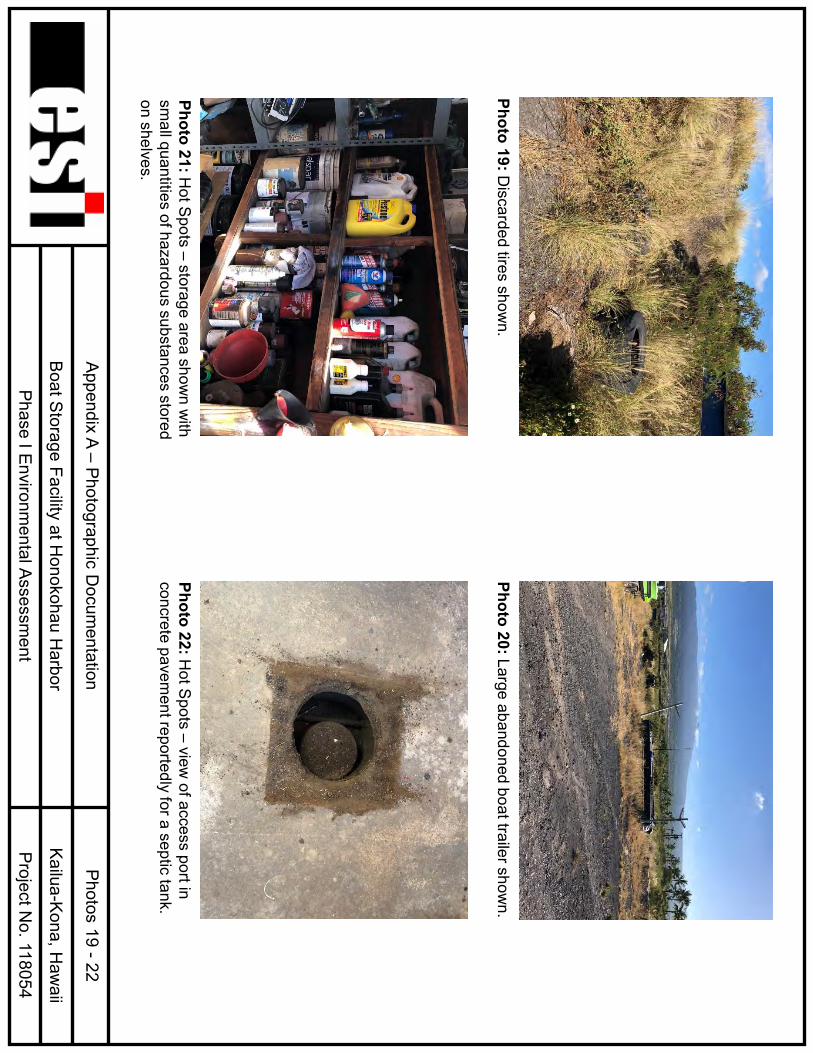
minimis releases of oil from boats and vehicles indicating poor housekeeping. • A welding and fabrication shop (Hot Spot Marine Fabrication) with small quantities of
hazardous materials, such as paints, solvents/thinners, coolant, cleaners, compressed gases, and solid waste.
• Two openings or portals to an apparent septic system, or cesspool, at the location of the Hot Spot fabrication shop at the northwest corner of the Subject Property.
• Uncontrolled dumping of waste materials or waste-like materials consisting of scrap metal, old tires, construction debris, wood and metal debris, unidentifiable materials, a tractor, and an old air compressor on or around the berms at the eastern and northern boundaries of the Subject Property, also indicating poor housekeeping.
• Apparent abandoned or derelict vessels and trailers, some with highly weathered exteriors that have resulted in releases of paints, metals, and other debris to the ground surface.
• An adjacent property to the west with numerous commercial businesses and activities, septic systems, and above ground and underground fuel storage tanks.
ESI considers the apparently undocumented waste water system at the Hot Spot fabrication shop, the uncontrolled dumping, a collection of otherwise de minimis release of oil, paint, or other hazardous substances, solid wastes and abandoned or derelict vessels cited above as recognized environmental conditions. Based on the results of the Phase I assessment, ESI concludes that the potential for releases exists from wastewater generated historically at the location of the Hot Spot shop, from solid wastes discarded or land-filled, the accumulation of waste-like materials (e.g., heavy equipment, scrap metal, various debris, fuel tanks and containers) and from derelict vessels and trailers (i.e., fuels and oil, batteries, paint solids, heavy metals). All of these may have impacted or pose an imminent threat of release that could impact the environmental integrity of the Subject Property, and therefore are considered recognized environmental conditions. In addition, based on the historical activities at the Subject Property, including the storage, repair and alteration of vessels in storage at the Subject Property since around 1983, and the lack of best management practices typically required by an NPDES permit, the surface soils of the Subject Property may be impacted by the accumulation of releases of hazardous substances (including petroleum) that otherwise might be considered de minimis and that accumulation of releases is considered a recognized environmental condition
Phase I Environmental Site Assessment 1-1 ESI/118054 Boat Storage Facility, Honokohau Harbor February 20, 2018
SECTION 1 – INTRODUCTION This report describes the Phase I Environmental Site Assessment completed by Environmental Science International, Inc. [ESI], on behalf of Pacific Marine Partners, LLC, for the property located at 74-429 Kealakehe Parkway at Honokohau Harbor, Kailua-Kona, Hawaii (Figures 1 and 2), hereinafter referred to as the “Subject Property.” The Subject Property is identified by the County of Hawaii Real Property Tax Office as a portion of Tax Map Key [TMK] No. (3) 7-4-008:003 and consists of approximately 9 acres (Figure 3). The Subject Property is occupied by a boat storage facility, a welding and fabrication business, and vacant land. 1.1 PURPOSE This assessment was undertaken to gather pertinent information regarding the Subject Property. It was performed to identify conditions at the Subject Property that could result in real or potential hazards or in environmental liabilities, as dictated by federal, state, and local statutes and regulations. Specific concerns investigated included the following: historical uses of the Subject Property, gross surface contamination, polychlorinated biphenyl [PCB]-containing items, underground storage tanks [USTs], aboveground storage tanks [ASTs], underground petroleum pipelines, evidence of the storage or use of hazardous materials, and processes that might generate or require the storage of hazardous wastes. This assessment provides a recent, documented account of conditions at the Subject Property that can be referenced by the user. The assessment meets what is defined as “good commercial and customary practice” for conducting an environmental site assessment, as outlined in the American Society for Testing and Materials [ASTM] standard practice E1527-13, Standard Practice for Environmental Site Assessments: Phase I Environmental Assessment Process (ASTM, 2013). This assessment complies with Environmental Protection Agency [EPA] regulations under Code of Federal Regulations [CFR] Title 40, Part 312, Innocent Landowners, Standards for Conducting All Appropriate Inquiries (EPA, 2018). 1.2 METHODOLOGY The methods by which this assessment was performed include a review of historical data and a review of federal and state agency records. Particular emphasis was placed on recent historical uses of the Subject Property, gross surface contamination, PCB-containing items, USTs, hazardous materials, and hazardous wastes. 1.2.1 Review of Historical Data The historical records review focused on identifying previous landowners, lessees, and land usage. These data were obtained through tax records, State of Hawaii Department of Health [DOH] records, maps, aerial photographs, and personal interviews. Of interest were operating practices on the Subject Property, development plans, and adjacent land use, from the initial utilization of the Subject Property to the present day. Aerial photographs are included in Appendix B.
Phase I Environmental Site Assessment 1-2 ESI/118054 Boat Storage Facility, Honokohau Harbor February 20, 2018
Tax records were reviewed to determine past owners and lessees of the Subject Property (Appendix C). Letters of correspondence to regulatory agencies and other parties are provided in Appendix D. The information provided by the DOH Solid and Hazardous Waste Branch [SHWB] and Hazard Evaluation and Emergency Response [HEER] Office consists of known environmental incidents (solid and hazardous wastes, wastewater discharges, chemical spills), citations and inspections by regulatory authorities, and current operating permits. Historical maps and aerial photographs present graphic illustrations of past Subject Property use. Other resources were reviewed, such as environmental audits and documents that could provide information concerning current and potential liability. Personal Interviews Interviews with people knowledgeable about the Subject Property are valuable sources of information concerning past and present activities that may not be found in state or municipal records. 1.2.2 Review of Regulatory Information Federal, state, and county environmental databases were reviewed for evidence of environmental impacts to the Subject Property and surrounding area, in accordance with ASTM Standard E1527-13. These include the following information sources. Federal Databases 1. The EPA National Priorities List [NPL] of hazardous waste sites to be considered for
remediation with federal funds, including delisted NPL sites. 2. The EPA Comprehensive Environmental Response Compensation Liability Information
System [CERCLIS] list of Comprehensive Environmental Response, Compensation, and Liability Act [CERCLA] activities. This includes No Further Remedial Action Planned [NFRAP] Sites.
3. The Resource Conservation and Recovery Act [RCRA] Generator List, which tracks hazardous waste from the point of generation to the point of disposal. This includes Corrective Action Sites [CORRACTS] and Treatment, Storage, and Disposal [TSD] sites.
4. The Emergency Response Notification System [ERNS] list provides information pertaining to oil dischargers and hazardous substance releases.
5. The Facility Index System contains both facility information and “pointers” to other sources that contain more detail. These include the Resource Conservation and Recovery Information System, the Permit Compliance System, and others.
6. The Federal Hazardous Materials Information Reporting System, which includes hazardous materials spills reported to the Department of Transportation [DOT].
7. The PCB Activity Database System identifies generators, transporters, commercial storers, and/or brokers and disposers of PCBs who are required to notify the EPA of such activities.
Phase I Environmental Site Assessment 1-3 ESI/118054 Boat Storage Facility, Honokohau Harbor February 20, 2018
State Databases 1. The DOH HEER Office database, which includes state-equivalent CERCLA sites, voluntary
cleanup sites, release notifications, and Brownfields sites. 2. The DOH SHWB database, which includes landfill and solid waste disposal sites, UST sites,
and Leaking UST [LUST] sites. County Database 1. Hawaii Fire Department [HFD] database, which lists hazardous material releases and
records of response. In addition to the in-house review of records and databases, ESI uses an independent data provider, Environmental Data Resources, Inc. [EDR]. EDR provides an independent search and database that are used to help ensure that all possible agency and private records for a particular site are retrieved. In addition to the databases noted above, EDR searches several other databases, including Records of Decisions by the State and Federal Judiciary, Federal Superfund Liens, and the RCRA Administrative Tracking System. A copy of the EDR report is included in Appendix E. 1.2.3 Property Inspection The purpose of a property inspection is to gather evidence of past releases of oil or hazardous materials, soil and groundwater contamination, conditions that could constitute a threat of release of oil or hazardous materials, items suspected to contain PCBs, past or present existence of USTs, the use, or storage of hazardous materials, and waste handling and disposal. Gross Surface Contamination Gross surface contamination often is an indication of an ongoing release or a past release of oil or hazardous materials, and it may be indicative of just a fraction of the total extent of subsurface soil or groundwater contamination. Evidence of gross surface contamination includes stained or discolored soils, stressed vegetation, and unusual odors. PCB-Containing Items PCBs are synthetic chemicals that were first introduced in 1929. Because of their chemical stability, electrical properties, and heat transfer capabilities, they were widely used in industry, particularly in electrical transformers, capacitors, and fluorescent light ballasts. Researchers in the 1960s found that exposure to PCBs posed a significant human health risk. In 1979, the EPA promulgated the Toxic Substances Control Act [TSCA], which regulates the use and disposal of PCB-containing items. As part of this assessment, an inventory of electrical transformers in close proximity to the Subject Property was made. Hawaii Electric Light Company (HELCO) maintains an extensive database of Hawaii Electric Light transformers that includes their PCB status. In addition, EPA regulations require that all untested mineral oil transformers manufactured prior to July 1, 1979,
Phase I Environmental Site Assessment 1-4 ESI/118054 Boat Storage Facility, Honokohau Harbor February 20, 2018
must be considered PCB contaminated. Hawaii Electric Light maintains that all of their transformers in use are in compliance with TSCA and all applicable related regulations. UST Systems As part of the assessment, an inventory of USTs at and proximal to the Subject Property was made. UST system management is strictly regulated by the EPA (40 CFR Part 280) and by the State of Hawaii, under Chapter 342L of the Hawaii Revised Statutes. Regulations include registering all UST systems with the DOH and the HFD. USTs currently in use must meet rigorous leak detection, corrosion protection, and spill and overfill prevention performance standards. In addition, UST systems that are out of service must be properly closed. Upon closure, an assessment of soil and groundwater contamination must be performed. Hazardous Materials The proper use and storage of hazardous materials is necessary to ensure a safe work place and prevent possible environmental damage due to spills or leaks of hazardous materials to the environment. Hazardous Waste Hazardous waste is strictly regulated by the EPA under RCRA. Waste generators are responsible for determining if their waste is hazardous, as defined in 40 CFR Part 261. The degree to which a generator is regulated is dependent upon the type and amount of waste generated. Owners and operators who improperly generate, treat, store, dispose of, or transport hazardous waste may be subject to fines imposed by local and federal regulators. In addition, poor management of hazardous waste may contribute to the contamination of air, soil, surface water, and groundwater. The cleanup of uncontrolled hazardous waste sites can be a costly and lengthy process. Asbestos-Containing Materials [ACM] Asbestos is the name of naturally occurring minerals that separate into strong, microscopic fibers that are heat resistant and durable. These qualities have made asbestos extremely useful in construction and industry. Asbestos has been used for thermal and acoustical insulation, fireproofing, roofing, flooring tiles, pipe insulation, cement piping, and decoration on exposed surfaces. Prior to 1982, ACM commonly were incorporated into structures. After 1982, ACM began to be phased out because of health concerns. Asbestos tends to break down into a dust of tiny fibers that remain suspended in air for long periods of time and can be inhaled easily. Because of their durability, these fibers can remain in the body for years. In general, asbestos-related diseases have a latency of 20 to 40 years after exposure. The presence of ACM does not necessarily imply that a health hazard exists. Unless a material is friable (i.e., it is crumbly and able to release fibers into the air), it poses no risk if left undisturbed. Asbestos disturbance is regulated under the National Emission Standards for Hazardous Air Pollutants [NESHAP] (40 CFR Part 61) and the Asbestos Hazard Emergency Response Act [AHERA] (40 CFR part 763).
Phase I Environmental Site Assessment 1-5 ESI/118054 Boat Storage Facility, Honokohau Harbor February 20, 2018
Neither a detailed inspection nor an ACM assessment was performed. Note that asbestos is a constituent of potential concern that is excluded from CERCLA and thus not covered under the all-appropriate inquiry rule. Important Terms Five important terms used in describing conditions at a Subject Property include material threat, historical recognized environmental condition, recognized environmental condition, controlled recognized environmental condition, and de minimis condition. These terms are defined in the ASTM standard and are described below. Material Threat. A physically observable or obvious threat that is reasonably likely to lead to a release and that could result in an impact to public health or the environment. Historical Recognized Environmental Condition. A past release of any hazardous substances or petroleum products that has occurred in connection with the property and has been addressed to the satisfaction of the applicable regulatory authority or has met unrestricted use criteria established by a regulatory authority, without subjecting the property to any required controls (e.g., property use restrictions, institutional controls, or engineering controls). Recognized Environmental Condition. The presence or likely presence of any hazardous substances or petroleum products in, on, or at a property (1) due to release to the environment, (2) under conditions indicative of a release to the environment, or (3) under conditions that pose a material threat of a future release to the environment. De minimis conditions are not recognized environmental conditions. Controlled Recognized Environmental Condition. A recognized environmental condition resulting from a past release of hazardous substances or petroleum products that has been addressed to the satisfaction of the applicable regulatory authority (e.g., issuance of a No Further Action letter or equivalent or meeting risk-based criteria established by regulatory authority), with hazardous substances or petroleum products allowed to remain in place subject to the implementation of required controls (e.g., engineering controls, institutional controls, activity and use limitations, and/or property use restrictions). De Minimis Condition. A condition that generally does not present a threat to human health or the environment and that generally would not be the subject of an enforcement action if brought to the attention of appropriate governmental agencies. An example of a de minimis release of oil is one that is below the reportable quantity defined in the State Contingency Plan (DOH, 1995a). A reportable quantity of oil is defined as (1) a petroleum-hydrocarbon sheen on surface water or any navigable water of the State, (2) free product on groundwater, (3) greater than 25 gallons of oil released into the environment, or (4) less than 25 gallons of oil released that is not contained and remediated within 72 hours.
Phase I Environmental Site Assessment 2-1 ESI/118054 Boat Storage Facility, Honokohau Harbor February 20, 2018
SECTION 2 – PHYSICAL SETTING The characteristics of subsurface soils, topography, geology, and hydrogeology in the area of the Subject Property were reviewed. Property characteristics were determined from a review of published federal reports and maps describing the topography, geology, and soil distribution in the area. 2.1 PROPERTY LOCATION AND SETTING The Subject Property is located at Honokohau Harbor, north of Kailua-Kona on the leeward side of the island of Hawaii. It is bordered on the north by Kaloko-Honokohau National Historical Park, on the east by vacant lava fields, on the south by Blue Ocean Mariculture, and on the west by Kealakehe Parkway. West and across Kealakehe Parkway is Honokohau Harbor Sea Store & Deli, a boat storage and repair business, and Captain Zodiac. A Department of Land and Natural Resources (DLNR) office and number of other small businesses and non-profit groups have been associated with the adjacent properties to the west. A paved boat washing area is adjacent to the northwest corner of the Subject Property (Figure 4). The Subject Property is located west (makai) of the State’s underground injection control [UIC] line, at a surface elevation of approximately 25 feet above mean sea level [amsl] (Figure 2). The nearest major body of surface water is Honokohau Harbor, which is located approximately 300 feet southwest of the Subject Property and directly connected to the Pacific Ocean. 2.2 CLIMATOLOGICAL CONDITIONS Climatological conditions in the area of the Subject Property consist of warm to moderate temperatures and low to moderate rainfall. The Subject Property is on the leeward side of the island of Hawaii (prevailing east to northeasterly trade winds). The average annual precipitation is approximately 19 inches, which occurs mainly between November and April (Giambellica et al., 2014). Average temperatures range from the low to high 70s (degrees Fahrenheit) (Giambellica et al., 2014). The annual pan evaporation is approximately 80 inches (DLNR, 1985). 2.3 REGIONAL AND PROPERTY GEOLOGY The island of Hawaii consists of five large shield volcanoes, Mauna Loa, Kilauea, Hualalai, Mauna Kea, and Kohala (MacDonald, et al., 1970). The western side of the island of Hawaii is known as the North and South District of Kona (Macdonald, et al., 1970). The Subject Property is located along the western flank of Hualalai. Hualalai is a dormant volcano that last erupted in the early 1800s. The lavas that erupted during the shield-building phase of Hualalai belong to the Hualalai Volcanic Series. The lavas of the Hualalai Volcanic Series interfinger with the lavas of the Kau Volcanic Series of Mauna Loa on the southern and eastern slopes. Small cinder and spatter cones are scattered at the source of the lava flows (Stearns Macdonald, 1946). On the southern slope, most of the lava flows are covered with a layer of ash. The Subject Property overlies ash and cinder deposits of the Hualalai Volcanic Series.
Phase I Environmental Site Assessment 2-2 ESI/118054 Boat Storage Facility, Honokohau Harbor February 20, 2018
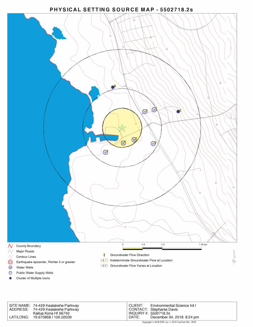
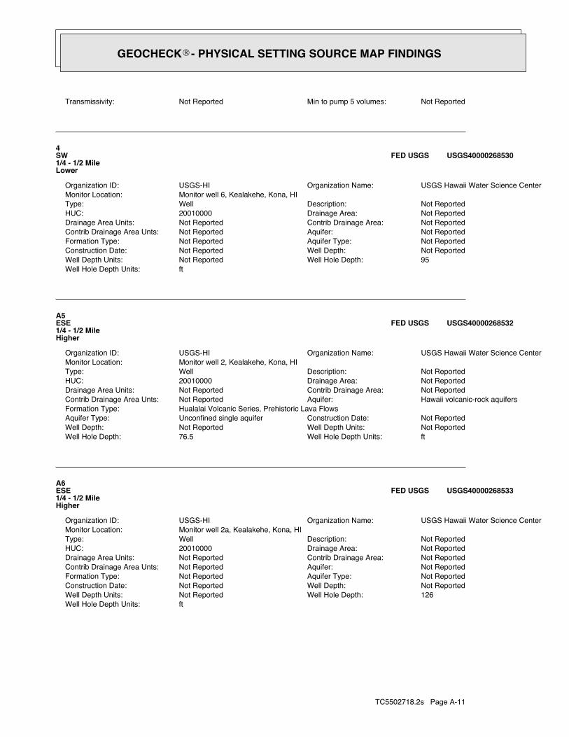
The soil in the area of the Subject Property consists of Honokohau Complex pahoehoe lava flows (United States Department of Agriculture, 2018). The lava flow soils consist of well-drained, thin organic materials that overlie pahoehoe lava bedrock. These soils are gently sloping to moderately steep. 2.4 REGIONAL AND PROPERTY HYDROGEOLOGY Groundwater in Hawaii exists in two principal types of aquifers. The first and most important type, in terms of drinking water resources, is the basal aquifer. The basal aquifer exists as a lens of fresh water floating on and displacing seawater within the pore spaces, fractures, and voids of the basalt that forms the underlying mass of each Hawaiian island. The basal aquifer can be both confined and unconfined by overlying caprock. Unlike much older Hawaiian islands Hawaii island’s basal aquifer is not confined by overlying caprock. Therefore, waters flow freely under gravity to streams and to the coastal reaches of the island from the basal aquifer. Therefore, the second type of aquifer, the caprock aquifer, which consists of various kinds of unconfined and semi-confined groundwater due to the presence of nearly impermeable sediments that form the caprock, does not occur on Hawaii island. Groundwater in the area of the Subject Property is part of the Keauhou Aquifer System of the Hualalai Aquifer Sector. The aquifer is classified as a basal, unconfined, flank aquifer. It is currently used as a drinking water source. It is classified as a low salinity water aquifer that is irreplaceable, and highly vulnerable to contamination (Mink and Lau, 1993). The depth to basal groundwater, the drinking water source in the area north of the Subject Property, is greater than 100 feet below ground surface. However, as illustrated on Figure 2, the Subject Property is located makai (below) the UIC line and therefore is not considered a current or potential drinking water source. The shallow water table beneath the Subject Property is likely to be tidally influenced, due to its close proximity to Honokohau Harbor. In the general area of the Subject Property, the direction of groundwater flow is likely to the west, towards the ocean. The nearest water well is located 0.35 miles upgradient from the Subject Property and is used for observation. Table 2.1 summarizes the non-drinking water wells located within 1 mile of the Subject Property. There are no drinking water supply wells located within 1 mile of the Subject Property. Any potential drinking water wells would be located east and upgradient of the Subject Property. Based on the direction and distance to the nearest drinking water well, it is unlikely that releases of hazardous substances at or in the immediate vicinity of the Subject Property have impacted or could impact drinking water sources.
Phase I Environm
ental Site Assessm
ent 2-3
ESI/118054 Boat Storage Facility, H
onokohau Harbor
February 20, 2018
TABLE 2.1
Nearest W
ater Wells
Boat Storage Facility at H
onokohau Harbor
Phase I Environmental Site Assessm
ent W
ell ID
Num
ber W
ell Nam
e or Location
Year C
onstructed Elevation
(amsl)
Distance from
Property (m
iles) G
radient/Direction
Depth
(feet bgs) O
wner
Status /U
se
Non-D
rinking Water W
ells 8-4060-003
Kaiser 2 -
- 0.35
Upgradient/N
ortheast -
Maryl G
roup, Inc. O
bservation
8-4060-002 Kaiser 1
- -
0.47 U
pgradient/East-
Northeast
- M
aryl Group, Inc.
Observation
8-4061-001 Kaho 1
1996 37
0.53 U
pgradient/North
52
U.S. N
ational Park Service, Kaloko-
Honokohau
Historical P
ark
Observation
8-4060-001 H
onokohau Q
uarry 1995
121 0.74
Upgradient/E
ast-N
ortheast 137
McC
lean H
onokohau Properties
Unused
Sources:
ED
R, 2018.
amsl
above mean sea level
bgs below
ground surface
Phase I Environmental Site Assessment 3-1 ESI/118054 Boat Storage Facility, Honokohau Harbor February 20, 2018
SECTION 3 – PROPERTY INFORMATION The Subject Property is owned by the State of Hawaii. It is occupied by Pacific Marine Partners LLC doing business as Honokohau Marine Storage, under a lease (revocable permit) with the DLNR. 3.1 PROPERTY DESCRIPTION AND CURRENT LAND USE The Subject Property consists of a 9-acre portion of a larger parcel (TMK (3) 7-4-008:003) (Figures 3 and 4). The surrounding properties consist primarily of commercial businesses, vacant land, and a national historic park. The surrounding properties are summarized in Table 3.1. The state land use designation for the area is Urban District and the County of Hawaii Zoning Designation is Open District. The Subject Property is located in Flood Zone X, which is determined to be outside the 0.2% annual chance floodplain. The Subject Property is also located within the County of Hawaii Special Management Area. The western six acres of the Subject Property are occupied by an open, fenced yard that is currently used as a boat storage facility (Honokohau Marine Storage) and a welding and fabrication business (Hot Spots). The boat storage facility is unpaved and covered by gravel (crushed lava rock) and includes over 300 stalls that can be individually rented (Figure 5). Hot Spots is located on the northwestern portion of the Subject Property and is covered with concrete pavement and contains a warehouse and fabrication shop. The eastern three acres of the Subject Property are vacant lava fields. 3.2 PROPERTY HISTORY Tax information, historical maps, aerial photographs, topographic maps, interviews with people knowledgeable about the Subject Property, and other sources of historical information were used to compile a history of the property and the surrounding area. Aerial photographs from 1954 to 2018 were reviewed. The parcel titleholder and lessees are summarized in Table 3.2. The aerial photographs reviewed are listed in Table 3.3 and are included in Appendix B. The historical maps reviewed are listed in Table 3.4. The Subject Property and Parcel 003 have been State-owned land since before 1967. The following is an excerpt from the November 9, 2017, Board of Land and Natural Resource, DLNR set aside and right of entry application:
“Before 1992, the Honokohau SBH was under the management authority of the Department of Transportation, Harbors Division (DOT). But in 1991, the legislature passed Act 272, Session Laws of Hawaii (1991), which provided for the transfer of all of the small boat harbors in the State from DOT to DLNR. DOBOR took over management of Honokohau SBH in approximately 1992. At its meeting of September 22, 2000, Item D-7, the Board approved the set-aside of lands designated as Tax Map Key: (3) 7-4-008:003 por., area 127.3 12 acres (Parcel 3), to
Phase I Environmental Site Assessment 3-2 ESI/118054 Boat Storage Facility, Honokohau Harbor February 20, 2018
DOBOR. See Exhibit 3 attached. This area included the harbor and general vicinity, including 4.3 72 acres of submerged lands in the harbor channel. Executive Order No. 3858 formalizing the set-aside was signed by the Governor on February 13, 2001. However, due to an error in preparing the executive order, it inadvertently set aside more land than the Board had approved. In addition to Parcel 3, Executive Order No. 3858 set aside TMK: (3) 7-4-008:04 1 (Parcel 41), area 7.25 acres, and the subject parcel, TMK: (3) 7-4-008:07 1 (Parcel 71), area 218.45 acres, to DOBOR. Subsequently, at its meeting of December 13, 2002, Item D-38, the Board approved the set-aside of Parcel 71 to DOBOR for marina and marina enhancement purposes. See Exhibit 4 attached. However, the Board’s approval action obtained after the execution of Executive Order No. 3858 did not cure the error in the executive order. Accordingly, Land Division staff prepared a second executive order, Executive Order No. 3984 signed by the Governor on April 1, 2003, which cancelled Executive Order No. 3858.
According to West Hawaii Today, “Gentry’s Kona Marina has operated the [boat storage] facility since 2003 when it took over a revocable permit that Gentry Properties had held from 1999 to 2003. From 1994 to 1999, Gentry Properties held a five-year lease that was not renewed; only revocable permits had been issued since.”
TABLE 3.1
Surrounding Properties Boat Storage Facility at Honokohau Harbor
Phase I Environmental Site Assessment
North South East West
Kaloko-Honokohau
National Historical Park TMK No.
(3) 7-4-008:025
Blue Ocean Mariculture TMK No.
(3) 7-4-008:003 (portion)
Vacant Lava Fields TMK No.
(3) 7-4-008:003 (portion)
Kealakehe Parkway
Honokohau Harbor Sea Store & Deli, boat storage and repair
business, and Captain Zodiac
TMK No. (3) 7-4-008:042
State boat washing area
TMK No. (3) 7-4-008:003
(portion)
TMK Tax Map Key
Phase I Environm
ental Site Assessm
ent 3-3
ESI/118054 Boat Storage Facility, H
onokohau Harbor
February 20, 2018
TABLE 3.2
Title Holders and Lessees of TM
K N
o. (3) 7-4-008:003 B
oat Storage Facility at Honokohau H
arbor Phase I Environm
ental Site Assessment
Year O
wner
Lessee/Permit
Notes
2018 State of H
awaii
- Fee ow
ner (117.987 acres)
2003 -
Gentry Kona M
arine, Inc. (G
KM, Inc.)
Revocable P
ermit
1991 -
General C
onstruction co. R
anch N
ew Parcel 7-4-8:051, R
evocable Perm
it
1990 -
General C
onstruction co. R
anch N
ew Parcel 7-4-8:050, R
evocable Perm
it
1999 -
Gentry Properties*
5 Year Lease
1986 -
General C
onstruction co. R
anch N
ew Parcel 7-4-8:046, Lease
1985 -
General C
onstruction co. R
anch N
ew Parcel 7-4-8:042, Lease
1984 -
General C
onstruction co. R
anch N
ew Parcel 7-4-8:041, Lease
1978 -
Palani Ranch
New
Parcel 7-4-8:036, Lease
1965 -
Palani Ranch
Lease
1952 -
Frank R. G
reenwell
Lease
Notes: The S
ubject Property is a portion of parcel 003 and included part of Parcel 075, also owned by the State of H
awaii, and leased to Kona B
lue W
ater Farms w
ith a mailing address care-of Keahole P
oint Fish LLC.
Source: County of H
awaii, R
eal Property Tax Office, D
ec. 2018 and Jan. 2019
*W
est Haw
aii Today.
TMK
Tax M
ap Key
- Inform
ation not available in tax records
Phase I Environmental Site Assessment 3-4 ESI/118054 Boat Storage Facility, Honokohau Harbor February 20, 2018
TABLE 3.3 Historical Aerial Photographs Reviewed
Boat Storage Facility at Honokohau Harbor Phase I Environmental Site Assessment
Date of Photograph Source October 1, 1954* EDR
November 10, 1976* EDR March 27, 1977* EDR April 29, 1985* EDR
September 21, 1992* EDR April 7, 2000 Google Earth April 8, 2000* EDR
October 13, 2001 Google Earth October 23, 2003 Google Earth
November 30, 2009 Google Earth July 24, 2011 Google Earth
January 9, 2013 Google Earth August 21, 2014 Google Earth August 22, 2016 Google Earth
May 15, 2018 Google Earth * Aerial photograph is included in Appendix B
TABLE 3.4
Historical Maps Reviewed Boat Storage Facility at Honokohau Harbor
Phase I Environmental Site Assessment
Year Source 1924 USGS, 7.5 Minute Series (Topographic) Keahole Point Quadrangle
1946 Geology and Groundwater Resources of the Island of Hawaii, Hawaii Division of Hydrography, Bulletin 9
1959 USGS, 7.5 Minute Series (Topographic) Keahole Point Quadrangle 1982 USGS, 7.5 Minute Series (Topographic) Keahole Point Quadrangle 1996 USGS, 7.5 Minute Series (Topographic) Keahole Point Quadrangle 2007 Geologic Map of the State of Hawaii, Sheet 8 – Island of Hawaii 2013 USGS, 7.5 Minute Series (Topographic) Keahole Point Quadrangle
Based on the review of historical maps and photographs, in 1954 the Subject Property and surrounding area were undeveloped land. By 1976, the Honokohau Boat Harbor was present, but the Subject Property remained undeveloped. By 1985, the western portion of the Subject Property was being used for storage, and the area to the south was developed with a
USGS United States Geological Survey
Phase I Environmental Site Assessment 3-5 ESI/118054 Boat Storage Facility, Honokohau Harbor February 20, 2018
warehouse. By 2000, the Subject Property was being used for boat storage and the surrounding area was developed with warehouses and open parking areas. Property Owners As early as 1952, the State of Hawaii held title to the land occupied by the Subject Property. The land is part of the Hawaiian Home Lands Trust, Section 5(b) lands of the Hawaii Admission Act. Parcel 003 has been subdivided numerous times over the past 50 years. In 1971, an easement was granted to the U.S. government to access the harbor. Lessees The Parcel 003 and the Subject Property were part of the Kaloko-Honokōhau National Historical Park designated in 1978. Prior to Pacific Marine Partners, LLC, doing business as Honokohau Marine Storage, GKM, Inc., was the last recorded holder of access and use rights under a DLNR revocable permit for the Subject Property. GKM’s revocable permit was terminated by DLNR in August 2018. Other encumbrances reported by DLNR-Land Division over Parcel 003 are summarized in the following grid, which contains information regarding the encumbrances that may have been issued over multiple parcels, or specifically to the area of encumbrances themselves (Public Lands Trust Information System [PLTIS], 2018).
TABLE 3.5 Summary of Parcel 003 Encumbrances
Boat Storage Facility at Honokohau Harbor Phase I Environmental Site Assessment
Identifier Lessor Agency
Lessee Area (ac) Subtype Character of Use
eo3858 DLNR-LD DLNR 134.564 Executive Order
lod25583 DLNR-LD U.S.A. 1.014 Perpetual Easement
Military
lod28397 DLNR-LD Hawaiian Telephone
0.0223 Perpetual Easement
Utility
rp6783 DLNR-LD U.S.A. 6.929 Permit (Land) Cultural
The content within the PLTIS, including maps and data, has been collected from multiple city, county, and state sources, and may not have been prepared for legal, engineering, or surveying purposes (PLTIS, 2018). 3.3 PREVIOUS ENVIRONMENTAL INVESTIGATIONS A Phase I Environmental Site Assessment was previously conducted at the Subject Property in October 2018 (Lehua Environmental Inc., 2018). No recognized environmental conditions were identified in connection with the Subject Property. The following de minimis items of environmental concern were noted in the report:
NOTES:
Phase I Environmental Site Assessment 3-6 ESI/118054 Boat Storage Facility, Honokohau Harbor February 20, 2018
• Various small petroleum stains were observed throughout the Subject Property during the site inspection. The report stated it appeared that the staining was from small boat and car/truck motor/engine part leaks, which is consistent with site use as a commercial parking area. The report recommended that spill pans/proper containment should be placed under all motorized equipment and storage containers that have the potential to release petroleum products or other potentially hazardous materials.
• Various improperly stored small quantities of petroleum product, such as motor oil, were observed at the Subject Property. The report recommended that these items should be properly stored in protected spill containment areas.
• Unmarked drums/containers were observed at the Subject Property. The report recommended that all unmarked drums/containers should be properly characterized and disposed of accordingly in accordance with County and State regulations.
• Flaking paint chips and paint in poor condition were observed on boats, construction materials, and on the ground surface at the Subject Property in several locations. It was noted that paint chips could contain lead. The report recommended that all loose and flaky paint be removed to prevent potentially lead-containing paint chips from entering the soil and stormwater sheet flow to the surrounding environment, including the ocean at Honokohau Harbor just downgradient from the Subject Property.
• The reported petroleum leaks/releases at Honokohau Harbor noted in the environmental database search (ERNS, SHWS), along with the general use of the area as a commercial harbor, represent an environmental concern since the potential for these types of releases is present. […]
No other environmental investigation reports for the Subject property were located during our review of the historical data.
Phase I Environmental Site Assessment 4-1 ESI/118054 Boat Storage Facility, Honokohau Harbor February 20, 2018
SECTION 4 – RECORDS REVIEW AND PREVIOUS FINDINGS A summary of the federal, state, and county records that were reviewed is provided below. This summary is based on information contained in the EDR report, state and county records, the Lehua Environmental report, and environmental investigative reports regarding the Subject Property and nearby sites. The record request conducted in the EDR report is dated December 4, 2018. 4.1 FEDERAL REGULATORY RECORDS Federal regulatory records were reviewed for evidence of environmental conditions at the Subject Property and nearby sites. Environmental conditions identified by regulatory records were evaluated based on the location of the site and the potential that the environmental condition could impact the Subject Property. 4.1.1 NPL Sites There are no active NPL sites within one mile or delisted NPL sites within one-half mile of the Subject Property. 4.1.2 CERCLIS Sites There are no CERCLIS sites within one-half mile of the Subject Property. 4.1.3 RCRA CORRACTS and TSD Sites There are no RCRA CORRACTS or TSD sites within one-half mile of the Subject Property. 4.1.4 RCRA Generators List There are no registered RCRA generators within one-quarter mile of the Subject Property. 4.1.5 Federal Institutional Control/Engineering Control Sites The Subject Property does not have any federal institutional or engineering controls. 4.1.6 ERNS Sites The TMK Parcel that includes the Subject Property is listed as an ERNS site. Based on the EDR report, a discharge of gasoline due to operator error was reported in October 2016. The reporting party stated that while fueling the compressor on a vessel, the error occurred, and gasoline was released to the deck of the vessel and the harbor. The amount spilled was less than 0.5 gallon of fuel. Booms and absorbents were applied, and the material was contained. The responsible company was listed as Blue Ocean Mariculture. Since this spill occurred at the harbor, it is not an environmental concern for the Subject Property.
Phase I Environmental Site Assessment 4-2 ESI/118054 Boat Storage Facility, Honokohau Harbor February 20, 2018
4.2 STATE REGULATORY RECORDS State regulatory records were reviewed for evidence of environmental conditions at the Subject Property and nearby sites. Environmental conditions identified by regulatory records were evaluated based on the location of the site and the potential that the environmental condition could impact the Subject Property. No environmental concerns were found. However, the activities conducted on the Subject Property appear to be included in Standard Industrial Code (SIC) Major Group 44: Water Transportation, Industry Group 449: Services Incidental to Water Transportation, subclassification 4493 Marinas. This SIC subclassification includes: Establishments primarily engaged in operating marinas. These establishments rent boat slips and store boats, and generally perform a range of other services including cleaning and incidental boat repair. They frequently sell food, fuel, and fishing supplies, and may sell boats. Establishments primarily engaged in building or repairing boats and ships are classified in Manufacturing, Industry Group 373. Establishments primarily engaged in the operation of charter or party fishing boats or rental of small recreational boats are classified in Services, Industry 7999.
▪ Boat yards, storage and incidental repair ▪ Marinas ▪ Marine basins, operation of ▪ Yacht basins, operation of
It therefore may require an NPDES Permit. No record of such a permit was available for the Subject Property. 4.2.1 State Hazardous Material Incident Sites Based on ESI’s review of the DOH HEER Office records and the EDR report, there was one hazardous material incident within one-half mile of the Subject Property that was reported to the DOH HEER Office (EDR, 2018). The site is listed as Kona Fuel and Marine (fuel dock), with a supplemental location listing of Hualalai Resort. Oil contamination was found in soil and the contaminated soil was removed. Retesting of soil samples yielded results below the DOH environmental action levels. The incident received a determination of no further action [NFA] from the DOH HEER office in 2014. 4.2.2 Voluntary Cleanup Sites Based on ESI’s review of the DOH HEER Office records and the EDR report, there are no voluntary cleanup sites within one-half mile of the Subject Property. 4.2.3 Solid Waste Landfill Sites There are no permitted Solid Waste Landfills within one-half mile of the Subject Property.
Phase I Environmental Site Assessment 4-3 ESI/118054 Boat Storage Facility, Honokohau Harbor February 20, 2018
4.2.4 Brownfields Sites There are no Brownfields sites within one-half mile of the Subject Property. 4.2.5 UST Sites According to the EDR report, there are no UST sites within one-quarter mile of the Subject Property. However, the EDR mapping is inaccurate and there is one UST site, GKM, Inc., located approximately 100 feet southwest of the Subject Property on the adjacent property (across Kealakehe Parkway). Three USTs are currently in use at the site (EDR, 2018). The USTs are located on the same property as Honokohau Harbor Sea Store & Deli (Figure 4). 4.2.6 LUST Sites Based on the review of DOH records, there are two LUST sites within one-half mile of the Subject Property. The two LUST sites are described below. Kona Fuel and Marine (Fuel Dock) is listed as a LUST site (facility ID 9-600469). The site address is listed as 74-381 Kealakehe Parkway and, according to the DOH Environmental Health Warehouse Map Viewer, the site is located on the south side of the Honokohau Boat Harbor. The release ID is 950088 and site cleanup has been completed. The site received a determination of NFA from the DOH SHWB in 2002 for the release. GKM, Inc., is listed as a LUST site (facility ID 9-601874). The site address is listed as 74-425 Kealakehe Parkway #23 and, according to the DOH Environmental Health Warehouse Map Viewer, the site is located on the adjacent property (across Kealakehe Parkway) to the southwest of the Subject Property. Two releases are associated with this site: release IDs 050039 and 020012. Site cleanup has been completed for both releases. The site received a determination of NFA from the DOH SHWB in 2002 and 2007 for the releases. 4.2.7 State Institutional/Engineering Control Registry Sites There are no registered state institutional or engineering controls at the Subject Property. 4.3 COUNTY REGULATORY RECORDS A request to obtain copies of incidents reported at the Subject Property was submitted to the HFD. No response had been received at the time of the report. Correspondence with the HFD is included in Appendix D. 4.4 ENVIRONMENTAL LIENS AND RESTRICTIONS We reviewed current recorded tax records at the County of Hawaii and could find no documentation indicating that there are environmental liens, restrictions, or activity and use limitations for the Subject Property (Appendix C).
Phase I Environmental Site Assessment 4-4 ESI/118054 Boat Storage Facility, Honokohau Harbor February 20, 2018
4.5 UNDERGROUND PIPELINES There are no known underground petroleum-oil-lubricant pipelines on the Subject Property or in the surrounding area. 4.6 PLANS AND PERMITS The County of Hawaii Real Property Tax website lists the building permits for the Subject Property TMK. The majority of the building permits available are for electrical and plumbing installations and alterations. Building permits for structures were primarily for buildings associated with the boat harbor. There were no building permits found specifically for the Subject Property. The Subject Property does not have any permanent buildings, except for the warehouse / fabrication shop used by Hot Spots. The list of available building permits is provided in Appendix F.
Phase I Environmental Site Assessment 5-1 ESI/118054 Boat Storage Facility, Honokohau Harbor February 20, 2018
SECTION 5 – PROPERTY INSPECTION ESI personnel conducted an on-site inspection of the Subject Property. The purpose of the inspection was to gather evidence concerning past releases of oil or hazardous materials, soil and groundwater contamination, conditions that could constitute a threat of a release of oil or hazardous materials, items suspected to contain PCBs, evidence of the past or present existence of USTs/ASTs, the use or storage of hazardous materials, and waste handling and disposal. 5.1 PROPERTY INSPECTION On December 6, 2018, ESI personnel (Ms. Stephanie Davis) conducted an on-site inspection of the Subject Property. Photographic documentation of the inspection is included in Appendix A. A summary of general property observations is included in Table 5.1 and discussed below.
TABLE 5.1 General Property Area Observations
Boat Storage Facility at Honokohau Harbor Phase I Environmental Site Assessment
Condition Observed (Yes/No) Hazardous Substances, Petroleum Products, and
Waste Materials Yes
ASTs or USTs Yes Odors No
Pools of Liquid No Storage Drums Yes
Unidentified Substance Containers (De Minimis) Yes Hazardous Substance and Petroleum Containers
(De Minimis) Yes
PCB-Containing Items No Heating/Cooling System No
Stains or Corrosion No Drains or Sumps Yes
Pits, Ponds, or Lagoons No Stained Soil or Pavement Yes
Stressed Vegetation No Solid Waste Yes Waste Water No
Wells No Septic System/Cesspool Yes
Evidence of Underground Pipelines No Evidence of Hydraulic Hoists No Painting or Sandblasting Area No
Phase I Environmental Site Assessment 5-2 ESI/118054 Boat Storage Facility, Honokohau Harbor February 20, 2018
The majority of the Subject Property is occupied by Honokohau Marine Storage, a boat storage facility (Photographs 1 and 2). The northwestern portion of the Subject Property is occupied by Hot Spots, a welding and fabrication business (Photograph 3). A soil/rock berm borders the northern and eastern sides of the area occupied by Honokohau Marine Storage (Photographs 4 and 5). The three acres beyond the berm on the eastern side is vacant (lava fields) (Photograph 6). The portion of the Subject Property occupied by Honokohau Marine Storage is unpaved and covered by gravel (crushed lava rock). There are over 300 stalls that can be individually rented for boat storage. A fence surrounds the western and southern boundaries and there are two gates that provide access from Kealakehe Parkway. An office trailer is located at the north gate (Figure 5; Photograph 7). The portion of the Subject Property occupied by Hot Spots is covered with concrete pavement and contains a warehouse / fabrication shop (including laundry and restroom facilities) and several small storage buildings (Photograph 8). Since there are no on-site storm drains to collect surface runoff, a small sump is used to collect rainwater, which is pumped offsite during heavy rainfall events. 5.2 STORAGE DRUMS No storage drums were observed at the Subject Property, except for open drums at Hot Spots used for storage of miscellaneous wood and metal, and a vessel with a rusted 55-gallon drum that appeared to contain fuel and was stored on the stern of the vessel on the northwestern corner of Honokohau Marine Storage of the Subject Property. 5.3 HAZARDOUS SUBSTANCES, PETROLEUM PRODUCTS, AND WASTE MATERIALS Honokohau Marine Storage Hazardous Substances: there were multiple locations where rusted metal pieces and paint chips were observed on the ground (see Figure 5 for locations; Photographs 9 through 12). Boat paint can potentially contain lead, copper, and tributyltin, and these chemicals may have been released to soil. Petroleum Products:
• several 5-gallon buckets/containers of oil were observed across the boat storage yard (see Figure 5 for locations; Photograph 13);
• small quantities of properly stored oil were observed behind the office trailer; • two small buckets of grease were observed on the ground at the location of a rusting
boat trailer; • de minimis petroleum stains were observed on the ground at several locations across
the boat storage yard; and • during the on-site inspection, oil was leaking from a boat engine and had created a 2-
foot by 2-foot area of stained soil (Photograph 14). ESI notified the on-site manager, Mr. Ikaika Solliday, and he reported that a drip pan would be placed under the engine.
Phase I Environmental Site Assessment 5-3 ESI/118054 Boat Storage Facility, Honokohau Harbor February 20, 2018
Waste Materials: • the soil berms along the eastern and northeastern boundaries contain tires and pieces of
concrete, wood, and metal debris (Photograph 15); • on the eastern side of the boat storage area discarded rubber, a boat cover, fencing
pipes, chain link fencing, wire mesh, wood debris, metal pieces, and several metal crab/shrimp pots were observed behind the boats (Photograph 16);
• at the southeast corner of the boat storage area, several discarded tires, an abandoned compressor, tractor, generator, and large boat trailer were observed (see Figure 5; Photographs 17 through 20); and
• several abandoned boats were observed along the perimeter of the boat yard; and according to a report by Honokohau Marine Storage, derelict vessels occupy 26 boat stalls or roughly 760 vessel feet.
Hot Spots Welding and Fabrication Hazardous Substances: several welding gas cylinders (e.g., argon, acetylene, and carbon dioxide) and small quantities of general lubricants, cleaners, paints, thinners, and coolant were observed and stored properly (Photograph 21). Two automotive batteries were stored on a pallet and are reportedly recycled as needed. 5.4 WELLS No groundwater monitoring wells or other types of wells were observed. 5.5 ABOVEGROUND AND UNDERGROUND STORAGE TANKS Honokohau Marine Storage currently uses a portable fuel tank to power a generator to provide electricity to the office trailer. No other ASTs or USTs were observed. 5.6 GROSS SURFACE CONTAMINATION As noted above in Section 5.3, there were multiple locations where rusted metal pieces and paint chips were observed on the ground; de minimis petroleum stains were observed on the ground at several locations across the boat storage yard; and oil was leaking from a boat engine during the on-site inspection and had created a 2-foot by 2-foot area of stained soil. 5.7 PCB-CONTAINING ITEMS No pole- or pad-mounted transformers were observed on the Subject Property. The abandoned compressor, tractor, and generator located at the southeast corner of the boat storage area may contain small quantities of PCB-containing oil. 5.8 POTABLE WATER SUPPLY Potable water is provided by the Hawaii County Department of Water Supply water system.
Phase I Environmental Site Assessment 5-4 ESI/118054 Boat Storage Facility, Honokohau Harbor February 20, 2018
5.9 SEWAGE AND DISPOSAL SYSTEM Honokohau Marine Storage does not have a permitted on-site sewage/disposal system. The storage yard is served by port-a-potty type latrines. Hot Spots reportedly has a septic system (tank and leach field) or cesspool that is used for the restroom and laundry sewage/wastewater. An access port was visible in the concrete pavement (Photograph 22), but it was not apparent whether it was connected to the septic tank or a former cesspool. According to the DOH Wastewater Branch, there are no records that indicate that the Subject Property has an individual wastewater treatment system (DOH, 2018). Real property records indicate that the adjacent parcel to the west (parcel 7-4-008:042) previously had a sewage/wastewater system (tanks and pumps) and later a “sewer connection” completed in 2014. Records from the DOH also indicate a former cesspool was replaced by a septic system at a “north side comfort station” at the harbor west of the Subject Property; and a septic system (septic/aerobic unit) was installed on the TMK Parcel in 1997 at the Hawaii Big Game Fishing Club facility adjacent to DOCARE offices and west of the Subject Property. Lastly, DLNR Engineering Division records indicate a septic system and absorption bed were planned for the DOCARE offices at the harbor. 5.10 INTERVIEWS On December 6, 2018, Mr. Ikaika Solliday, Operations Manager for Honokohau Marine Storage, was interviewed. Mr. Solliday has been associated with the Subject Property since November 1, 2018, when the new lease commenced. Mr. Solliday noted the following environmental concerns: oil stains under boats, the abandoned tractor and air compressor may contain small quantities of PCB-containing oil, the berms around the Subject Property may contain debris/solid waste, and there is potentially a cesspool at Hot Spots welding shop. No other environmental concerns were noted.
Phase I Environmental Site Assessment 6-1 ESI/118054 Boat Storage Facility, Honokohau Harbor February 20, 2018
SECTION 6 – DATA GAPS AND EXCEPTIONS 6.1 DATA GAPS There are no significant data gaps associated with the Subject Property. A real property field book 1967 entry indicates that in 1965 a “Rubbish Dump Site“ and a proposed Kealakehe School were planned for Parcel 003; however, no other information was available regarding the actual establishment of a dump site or landfill on Parcel 003. The adjacent property to the west includes a number of vendors and tenants over time and tenant occupancy, rights of entry to common areas, and terms of individual leases or leased area are unclear. 6.2 DEVIATIONS The Phase I Environmental Site Assessment was conducted in accordance with ASTM Standard E1527-13. 6.3 VAPOR ENCROACHMENT CONDITION No evidence of vapor encroachment was discovered during this assessment 6.4 LIMITATIONS There were no limitations while conducting the assessment.
Phase I Environmental Site Assessment 7-1 ESI/1150152 Boat Storage Facility, Honokohau Harbor February 20, 2018
SECTION 7 – FINDINGS AND CONCLUSIONS ESI performed a Phase I Environmental Site Assessment of the Subject Property. The assessment was performed in conformance with ASTM Standard E1527-13. The purpose of the assessment was to evaluate if current or past operations at the Subject Property or in the immediate vicinity have impacted or could potentially impact the environmental integrity of the Subject Property. 7.1 FINDINGS Based on a review of federal records, the TMK Parcel, is listed as an ERNS site due to a release of fuel from a vessel in the harbor to the west. The record indicates that there are no NPL sites within one-mile and no CERCLIS, RCRA-CORRACTS, or TSD sites within one-half mile of the Subject Property. There were no CERCLIS NFRAP sites within one-half mile of the Subject Property. There were no registered LQG, SQGs, and CESQGs within one-quarter mile of the Subject Property. According to the database search, there are no UST sites within one-quarter mile of the Subject Property. However, one UST site was identified that is located approximately 100 feet southwest of the Subject Property, across Kealakehe Parkway. Three USTs are currently in use at the GKM, Inc., site. There is one LUST site within one-half mile of the Subject Property that is topographically upgradient. A request to obtain copies of incidents reported at the Subject Property was submitted to the HFD. No response has been received to date. There are no voluntary cleanup sites within one-half mile of the Subject Property. Based on a records review, there was a release of waste oil to the harbor west of the Subject Property in 2012. There were no hazardous material incidents reported for the Subject Property. ESI personnel conducted a site inspection on December 6, 2018. During the site inspection the following were observed.
• A number of temporary structures, including an office trailer and one permanent structure with a concrete slab floor.
• An unpaved, small boat storage yard near its apparent storage capacity. • Small-capacity petroleum storage tanks and pails (fuel and lubricating oil), and de
minimis releases of oil from boats and vehicles indicating poor housekeeping. • A welding and fabrication shop (Hot Spot Marine Fabrication) with small quantities of
hazardous materials, such as paints, solvents/thinners, coolant, cleaners, compressed gases, and solid waste.
• Two openings or portals to an apparent septic system, or cesspool, at the location of the Hot Spot fabrication shop at the northwest corner of the Subject Property.
• Uncontrolled dumping of waste materials or waste-like materials consisting of scrap metal, old tires, construction debris, wood and metal debris, unidentifiable materials, a tractor, and an old air compressor on or around the berms at the eastern and northern boundaries of the Subject Property, also indicating poor housekeeping.
Phase I Environmental Site Assessment 7-2 ESI/1150152 Boat Storage Facility, Honokohau Harbor February 20, 2018
• Apparent abandoned or derelict vessels and trailers, some with highly weathered exteriors that have resulted in releases of paints, metals, and other debris to the ground surface.
• An adjacent property to the west with numerous commercial businesses and activities, septic systems, and above ground and underground fuel storage tanks.
ESI considers the apparently undocumented waste water system at the Hot Spot fabrication shop, the uncontrolled dumping, a collection of otherwise de minimis release of oil, paint, or other hazardous substances, solid wastes and abandoned or derelict vessels cited above as recognized environmental conditions. Based on the results of the Phase I assessment, ESI concludes that the potential for releases exists from wastewater generated historically at the location of the Hot Spot shop, from solid wastes discarded or land-filled, the accumulation of waste-like materials (e.g., heavy equipment, scrap metal, various debris, fuel tanks and containers) and from derelict vessels (i.e., fuels and oil, batteries, pant solids, heavy metals). All of these may have impacted or pose an imminent threat of release that could impact the environmental integrity of the Subject Property, and therefore are considered recognized environmental conditions. In addition, based on the historical activities at the Subject Property, including the storage, repair and alteration of vessels in storage at the Subject Property since around 1983, and the lack of best management practices typically required by an NPDES permit, the surface soils of the Subject Property may be impacted by the accumulation of releases of hazardous substances (including petroleum) that otherwise might be considered de minimis. and that accumulation of releases is considered a recognized environmental condition. 7.2 CONCLUSIONS In accordance with Section 12.8 of ASTM Standard E1527-13 (ASTM, 2013), we make the following statement.
We have performed a Phase I Environmental Site Assessment in conformance with the scope and limitations of ASTM Standard Practice E1527-13 at the Subject Property, identified as a portion of TMK No. (3) 7-4-008:003. Any exceptions to, or deletions from, this practice are described in Section 6 of this report. This assessment has revealed evidence of recognized environmental conditions in connection with the Subject Property.
Phase I Environmental Site Assessment 8-1 ESI/118054 Boat Storage Facility, Honokohau Harbor February 20, 2018
SECTION 8 – QUALIFICATIONS AND LIMITATIONS Our professional services have been performed and our findings obtained in accordance with customary principles and practices in the fields of environmental science and engineering. ESI is not responsible for the independent conclusions, opinions, or recommendations made by others based on the information presented in this report. In compliance with Section 12.13 of ASTM Standard E1527-13 (ASTM, 2013), ESI makes the following statements.
We declare that, to the best of our professional knowledge and belief, we meet the definition of Environmental Professional as defined in 40 CFR 312.10.
We have the specific qualifications based on education, training, and experience to assess the nature, history, and setting of the subject property. We have developed and performed all the appropriate inquiries in conformance with the standards and practices set forth in 40 CFR Part 312.
Phase I Environmental Site Assessment 9-1 ESI/118054 Boat Storage Facility, Honokohau Harbor February 20, 2018
SECTION 9 – REFERENCES ASTM, 2013, Standard Practice for Environmental Site Assessments: Phase I Environmental Site Assessment Process, Method E1527-13, November 1, 2013. Dane Hiromasa, Telephone Interview, 2018, Department of Health (DOH), Wastewater Branch. Kealakehe Health Center, Kealakekua, Hawaii, December 21, 2018. Department of Land and Natural Resources (DLNR), 1985, Pan Evaporation: State of Hawai’i 1894-1983, Report R74, Division of Water and Land Development, August 1985. DLNR, 2017, Set Aside to the Division of Boating and Ocean Recreation for Small Boat Harbor Board of Land and Natural Resources PSF No.: 1 7HD-05 1, State of Hawaii, Honolulu, Hawaii. November 9, 2017. DLNR, 2018, Termination of Revocable Permit (RP) No. 5, Dated August 30, 2016, to GKM, INC. (Permittee) for a Boat/Trailer Storage Facility and Employee Parking, Honokohau Small Boat Harbor, Kealakehe, North Kona, Island of Hawaii (3) 7-4-008:003 (Por.), August 10, 2018. Department of Health (DOH), 1995a, State Contingency Plan: Hawaii Administrative Rules, Title 11, Chapter 451, August 17, 1995. EDR, 2018. 74-429 Kealakehe Parkway, Kailua Kona, HI 96740, Inquiry Number 5502718.2s, December 4, 2018. EPA, 2018, Innocent Landowners, Standards for Conducting All Appropriate Inquiries, 40 CFR 312, July 1, 2018. Available online: https://www.ecfr.gov/cgi-bin/text-idx?tpl=/ecfrbrowse/Title40/40cfr312_main_02.tpl Foote, D. E., Hill, E. L., Nakamura, S. and Stephens, F., 1972, Soil Survey of the Islands of Kauai, Oahu, Maui, Molokai, and Lanai, State of Hawaii, U.S. Department of Agriculture Soil Conservation Service in Cooperation with the University of Hawaii Agricultural Experiment Station, August 1972. Giambelluca, T.W., X. Shuai, M.L. Barnes, R.J. Alliss, R.J. Longman, T. Miura, Q. Chen, A.G. Frazier, R.G. Mudd, L. Cuo, and A.D. Businger. 2014. Evapotranspiration of Hawai‘i. Final report submitted to the U.S. Army Corps of Engineers—Honolulu District, and the Commission on Water Resource Management, State of Hawai‘i. Lehua Environmental Inc., 2018, Phase I Environmental Site Assessment, 74-429 Kealakehe Parkway, Kailua Kona, HI 96740, Tax Map Key (3) 7-4-008:003 (Portion), October 2018. Public Lands Trust Information System, State of Hawaii. Available online: https://pltis.hawaii.gov/
Phase I Environmental Site Assessment 9-2 ESI/118054 Boat Storage Facility, Honokohau Harbor February 20, 2018
Macdonald, Gordon, A. and Abbott, Agatin T., 1970, The Geology of Hawaii, Volcanoes in the Sea, University Press of Hawaii, 1970. Mink, John F. and Lau, L. Stephen, 1993, Aquifer Identification and Classification for the Island of Hawaii, Groundwater Protection Strategy for Hawaii, Water Resources Research Center Technical Report No. 191, May 1993. Stearns, H. T. and Macdonald, G. A., 1946, Geology and Groundwater Resources of the Island of Hawaii, Hawaii Division of Hydrography. Bulletin 9, 430p, October 1946. United States Department of Agriculture, 2018, Soil Survey Staff, Natural Resources Conservation Service, United States Department of Agriculture, Web Soil Survey, Available online at http://websoilsurvey.sc.egov.usda.gov/. Accessed December 18, 2018. Records Requested: DOH SHWB Records Request DOH HEER Office Records Request Hawaii Fire Department HELCO
Records Request Records Request
FIGURES
270
250
19
1919
19
MA
UN
A
LO
A
HA
WI
OP
IHIK
AO
KA
LAP
AN
A
NA
ALE
HU
MILO
LII
HO
NA
UN
AU
KA
ILUA
-KO
NA
KA
WA
IHA
E
HO
NO
KA
A
KA
UN
A P
OIN
T
KA
LAE
HILO
BA
Y
PA
PA
IKO
U
WA
IME
A
MA
UN
A
KE
A
HO
NO
MU
MO
UN
TAIN
VIE
W
HILO
KI
LA
UE
A
CA
PTA
INC
OO
K
HO
LUA
LOA
VO
LCA
NO
HU
AL
AL
I
KA
LAO
A
PA
HA
LA
19190
200
200190
180
11160
11
11
11
130
130
132
137
SITE LOC
ATIO
NSITE LO
CA
TION
SITE LOC
ATIO
NSITE LO
CA
TION
The accuracy of this document is lim
ited to the qualityand scale of the source inform
ation. This document is
not a legal representation of an engineered survey.
NO
TES
SOU
RC
ES
ES
RI U
SA
Topo Maps. N
ational Geographic S
ociety,i-cubed. 2013.
http://planning.hawaii.gov/gis, 2018.
NORTH
GR
AP
HIC
SC
ALE
00.5
0.5
Scale in M
ilesEN
VIRO
NM
ENTA
L SCIEN
CE IN
TERN
ATIO
NA
L
FIGU
RE 1
REG
ION
AL LO
CA
TION
& TO
POG
RA
PHIC
MA
PP
HA
SE
I EN
VIR
ON
ME
NTA
L SITE
AS
SE
SS
ME
NT
Boat S
torage Facility at Honokohau H
arbor74-429 K
ealakehe Parkw
ay, Kailua-K
ona, Haw
aiiTM
K N
o. (3) 7-4-008:003 (Portion)
SITE LOC
ATIO
NSITE LO
CA
TION
SITE LOC
ATIO
N
The accuracy of this document is lim
ited to the qualityand scale of the source inform
ation. This document is
not a legal representation of an engineered survey.
NO
TES
SOU
RC
ESH
-2, Keahole P
oint, Haw
aii, Island of Kauai-W
aimea
District,S
tate of Haw
aii, Departm
ent of Health,
Underground Injection C
ontrol Program
, Effective -
July 6, 1984, U.S
. Departm
ent of the InteriorG
eological Survey, 1983.
http://planning.hawaii.gov/gis, 2018.
Underground Injection C
ontrol [UIC
]Line
Drinking W
ater Well
Injection Well
Other W
ell
LEGEN
D
NORTH
GR
AP
HIC
SC
ALE
00.5
0.5
Scale in M
iles
ENVIR
ON
MEN
TAL SC
IENC
E INTER
NA
TION
AL
FIGU
RE 2
UIC
LINE &
WELL LO
CA
TION
MA
PP
HA
SE
I EN
VIR
ON
ME
NTA
L SITE
AS
SE
SS
ME
NT
Boat S
torage Facility at Honokohau H
arbor74-429 K
ealakehe Parkw
ay, Kailua-K
ona, Haw
aiiTM
K N
o. (3) 7-4-008:003 (Portion)
SITE LOC
ATIO
NSITE LO
CA
TION
SITE LOC
ATIO
NSITE LO
CA
TION
SITE LOC
ATIO
NSITE LO
CA
TION
SITE LOC
ATIO
N
TMK
NO
. (3)7-4-008:003
TMK
NO
. (3)7-4-008:072
TMK
NO
. (3)7-4-008:025
TMK
NO
. (3)7-4-008:042
TMK
NO
. (3)7-4-008:003
(portion)TM
K N
O. (3)
7-4-008:050
TMK
NO
. (3)7-4-020:999
TMK NO. (3) 7-4-008:999
TMK
NO
. (3)7-4-008:010
KE
AL
AK
EH
E
P
AR
KW
AY
QU
EE
N
K
AA
HU
MA
NU
HW
Y
ENVIR
ON
MEN
TAL SC
IENC
E INTER
NA
TION
AL
FIGU
RE 3
TMK
MA
PP
HA
SE
I EN
VIR
ON
ME
NTA
L SITE
AS
SE
SS
ME
NT
Boat S
torage Facility at Honokohau H
arbor74-429 K
ealakehe Parkw
ay, Kailua-K
ona, Haw
aiiTM
K N
o. (3) 7-4-008:003 (Portion)
The accuracy of this document is lim
ited to the qualityand scale of the source inform
ation. This document is
not a legal representation of an engineered survey.
NO
TES
SOU
RC
ES
Property B
oundary,TM
K N
o. (3) 7-4-008:003 (Portion)
TMK
Property B
oundary
LEGEN
D
NORTH
GR
AP
HIC
SC
ALE
0400
400
Scale in Feet
http://planning.hawaii.gov/gis, 2018.
KE
AL
AK
EH
E
P
AR
KW
AY
HO
NO
KO
HA
UM
AR
INE
STOR
AG
E
HO
NO
KO
HA
UM
AR
INE
STOR
AG
E
HO
NO
KO
HA
UM
AR
INE
STOR
AG
E
HO
NO
KO
HA
UM
AR
INE
STOR
AG
E
HO
NO
KO
HA
UM
AR
INE
STOR
AG
E
HO
NO
KO
HA
UM
AR
INE
STOR
AG
E
HO
NO
KO
HA
UM
AR
INE
STOR
AG
E
CA
PTAIN
ZOD
IACBLU
E OC
EAN
MA
RIC
ULTU
RE
BLU
E OC
EAN
MA
RIC
ULTU
RE
BO
AT STO
RA
GE
& R
EPAIR
BO
AT STO
RA
GE
& R
EPAIR
HO
NO
KO
HA
UH
AR
BO
R SEA
STOR
E & D
ELI
HO
NO
KO
HA
UH
AR
BO
R SEA
STOR
E & D
ELI
PAVED
BO
AT
WA
SHIN
G A
REA
PAVED
BO
AT
WA
SHIN
G A
REA
KA
LOK
O-H
ON
OK
OH
AU
NA
TION
AL H
ISTOR
IC PA
RK
KA
LOK
O-H
ON
OK
OH
AU
NA
TION
AL H
ISTOR
IC PA
RK
VAC
AN
TLA
VA FIELD
VAC
AN
TLA
VA FIELD
HO
NO
KO
HA
UB
OA
T HA
RB
OR
HO
NO
KO
HA
UB
OA
T HA
RB
OR
CA
PTAIN
ZOD
IAC
CA
PTAIN
ZOD
IAC
ENVIR
ON
MEN
TAL SC
IENC
E INTER
NA
TION
AL
FIGU
RE 4
AR
EA M
AP
PH
AS
E I E
NV
IRO
NM
EN
TAL S
ITE A
SS
ES
SM
EN
TB
oat Storage Facility at H
onokohau Harbor
74-429 Kealakehe P
arkway, K
ailua-Kona, H
awaii
TMK
No. (3) 7-4-008:003 (P
ortion)
The accuracy of this document is lim
ited to the qualityand scale of the source inform
ation. This document is
not a legal representation of an engineered survey.
NO
TES
SOU
RC
ES
Property B
oundary,TM
K N
o. (3) 7-4-008:003 (Portion)
LEGEN
D
NORTH
GR
AP
HIC
SC
ALE
0250
250
Scale in Feet
Street M
ap. 19°40'15.1"N 156°01'13.2"W
. Google
Map 2018. D
ecember 14, 2018.
http://planning.hawaii.gov/gis/, 2018.
KE
AL
AK
EH
E
P
AR
KW
AY
HO
NO
KO
HA
UM
AR
INE
STOR
AG
E
HO
NO
KO
HA
UM
AR
INE
STOR
AG
E
HO
NO
KO
HA
UM
AR
INE
STOR
AG
E
HO
NO
KO
HA
UM
AR
INE
STOR
AG
E
HO
NO
KO
HA
UM
AR
INE
STOR
AG
E
HO
NO
KO
HA
UM
AR
INE
STOR
AG
E
HO
NO
KO
HA
UM
AR
INE
STOR
AG
E
HO
NO
KO
HA
UM
AR
INE
STOR
AG
EFence
Gate
Gate
End of fence line
Large abandoned boat trailer&
several discarded tiresO
ne 5-gallonbucket oil
Rusting boat trailer
Hot S
pots (welding &
fabrication) / severalw
elding gas cylinders /sm
all quantities of generallubricants, cleaners,
paints, thinners, coolant
Office Trailer
Generator &
portable fueltank / sm
all quantities oil
Stall #11
Rusting boat trailer w
ith flakes of rustedm
etal on ground, 2 small buckets of grease.
Boat currently leaking oil on ground
(2' x2' stain on soil)
Fence
Storage boxes w
ith tire,one 5-gallon oil container
Berm
(along northern boundary)
Sm
aller berm contains pieces
of concrete, wood, m
etal debris
Metal beam
s, wood adjacent to berm
Large abandoned wooden boat w
ith paint flakingonto ground; ~4' x 4' soil pile south of boatcontains paint chips &
potentially burned debris
Ho'ihi K
ai boat with paint flaking onto ground
Rusty m
etal pieces on ground
Discarded carpet, tire
Dolphin Journeys boat w
ith paint flaking onto ground
Discarded rubber, boat cover,
fencing pipes, chain link fence, wire
mesh, w
ood debris, & m
etal pieces
Several m
etal crab/shrimp pots
Stall #36
Two 5-gallon
buckets oil
Berm
along eastern boundary with m
iscellaneousm
etal & w
ood debris, discarded tires
Large pieces of rusted metal on ground,
several discarded tires, abandonedcom
pressor, tractor, & generator
The accuracy of this document is lim
ited to the qualityand scale of the source inform
ation. This document is
not a legal representation of an engineered survey.
NO
TES
SOU
RC
ES
Property B
oundary,TM
K N
o. (3) 7-4-008:003 (Portion)
LEGEN
D
NORTH
GR
AP
HIC
SC
ALE
0150
150
Scale in Feet
Street M
ap. 19°40'15.1"N 156°01'13.2"W
. Google
Map 2018. D
ecember 14, 2018.
http://planning.hawaii.gov/gis/, 2018.
ENVIR
ON
MEN
TAL SC
IENC
E INTER
NA
TION
AL
FIGU
RE 5
SITE MA
PP
HA
SE
I EN
VIR
ON
ME
NTA
L SITE
AS
SE
SS
ME
NT
Boat S
torage Facility at Honokohau H
arbor74-429 K
ealakehe Parkw
ay, Kailua-K
ona, Haw
aiiTM
K N
o. (3) 7-4-008:003 (Portion)
APPENDIX A
Photographic Documentation
Appendix A –
Photographic D
ocumentation
Boat S
torage Facility at Honokohau
Harbor
Project N
o. 118054
Photo 1:View of H
onokohauM
arine Storage
boat storage yard, facing north.Photo 2: View
of Honokohau
Marine S
torage boat storage yard, facing east.
Photo 3:Location of Hot S
pots welding and
fabrication shop shown facing w
est.Photo 4:View
of soil berm along eastern
boundary, facing north.
Photos 1 -4
Phase I E
nvironmental A
ssessment
Kailua-K
ona, Haw
aii
Appendix A –
Photographic D
ocumentation
Boat S
torage Facility at Honokohau
Harbor
Phase I E
nvironmental A
ssessment
Project N
o. 118054
Photo 6:View of adjacent vacant lava fields,
facing north.
Photos 5 -8
Kailua-K
ona, Haw
aii
Photo 5:View of soil/rock berm
along northern boundary od the S
ubject Property, facing east
Photo 7:Office trailer for H
onokohauM
arine S
torage shown.
Photo 8:Hot S
pots area shown w
ith concrete-pavem
ent, storage building, and temporary
structures.
Appendix A –
Photographic D
ocumentation
Boat S
torage Facility at Honokohau
Harbor
Phase I E
nvironmental A
ssessment
Project N
o. 118054
Photos 9 -10
Kailua-K
ona, Haw
aii
Photo 9:View of pieces of rusted m
etal on ground at southw
est corner of the Subject
Property.
Photo 10:Close-up view
of rusted metal on
ground.
Appendix A –
Photographic D
ocumentation
Boat S
torage Facility at Honokohau
Harbor
Phase I E
nvironmental A
ssessment
Project N
o. 118054
Photos 11 -12
Kailua-K
ona, Haw
aii
Photo 11:Dolphin Journeys boat show
n with
paint flaking onto ground.Photo 12:P
ieces of rusted metal and debris on
ground below boat trailer.
Appendix A –
Photographic D
ocumentation
Boat S
torage Facility at Honokohau
Harbor
Phase I E
nvironmental A
ssessment
Project N
o. 118054
Photos 13 -14
Kailua-K
ona, Haw
aii
Photo 13:Five-gallon oil container next to storage box show
n.Photo 14:A
pparent oil stained soil and leak show
n from boat engine.
Appendix A –
Photographic D
ocumentation
Boat S
torage Facility at Honokohau
Harbor
Phase I E
nvironmental A
ssessment
Project N
o. 118054
Photo 16:Discarded rubber, boat cover, fencing
pipes, and chain link fencing shown.
Photos 15 -18
Kailua-K
ona, Haw
aii
Photo 15:Pieces of concrete, w
ood, and metal
debris along soil berm show
n.
Photo 17:Abandoned com
pressor shown.
Photo 18:Abandoned generator show
n.
Appendix A –
Photographic D
ocumentation
Boat S
torage Facility at Honokohau
Harbor
Phase I E
nvironmental A
ssessment
Project N
o. 118054
Photo 20:Large abandoned boat trailer shown.
Photos 19 -22
Kailua-K
ona, Haw
aii
Photo 19:Discarded tires show
n.
Photo 21:Hot S
pots –storage area show
n with
small quantities of hazardous substances stored
on shelves.
Photo 22:Hot S
pots –view
of access port in concrete pavem
ent reportedly for a septic tank.
APPENDIX B
Aerial Photographs
5434002.8
2000
= 625'
5434002.8
1992
= 625'
5434002.8
1985
= 625'
Subject boundary not shown because it exceeds image extent or image is not georeferenced.
5434002.8
1977
= 625'
5434002.8
1976
= 625'
Subject boundary not shown because it exceeds image extent or image is not georeferenced.
5434002.8
1954
= 625'
APPENDIX C
Tax and Title Records
Recen
t Sales in
Area
Previou
s Parcel
Next P
arcelR
eturn
to Main
Search
Pag
eH
awaii H
ome
Real P
roperty H
ome
Ow
ner an
d P
arcel Inform
ationO
wn
er Nam
e S
TATE O
F HAW
AII Fee O
wner
Today's D
ate D
ecember 19, 2018
Mailin
g A
dd
ress
Parcel N
um
ber
740080030000
Location A
dd
ress 74-429 K
EALA
KEH
E PARKW
AY
Project N
ame
Prop
erty Class
RES
IDEN
TIAL
Parcel M
ap Plat (TM
K) M
aps
Neig
hb
orhood
Cod
e L7000-5
Land
Area (acres)
117.987
Legal In
formation
(20000 SF) D
RO
PPED IN
TO N
EW PA
RCEL 7408-75
Land
Area (ap
proxim
ate sq ft)
5,139,514
A
ssessmen
t Inform
ation S
how
Historical A
ssessmen
ts
Year
Prop
erty C
lass
Market
Land
V
alue
Ded
icated
Use V
alue
Assessed
Land
Land
Exem
ption
Market
Bu
ildin
g
Valu
e
Assessed
B
uild
ing
V
alue
Bu
ildin
g
Exemp
tionTotal M
arket Valu
eTotal
Taxable
Valu
e2018
RES
IDEN
TIAL
$ 2,807,300 $ 0
$ 2,807,300 $ 2,807,300
$ 650,500 $ 650,500
$ 650,500 $ 3,457,800
$ 0
Lan
d In
formation
Prop
erty Class
Sq
uare Footag
eA
creage
Ag
ricultu
ral Usag
e
5,139,514117.987
C
omm
ercial Imp
rovemen
t Inform
ation
Prop
erty Class
Bu
ildin
g C
ardB
uild
ing
Nu
mb
erIm
provem
ent
Nam
eId
entical
Un
itsU
nits
Stru
cture Typ
eY
earB
uilt
Effective Year
Bu
iltG
ross Bu
ildin
gD
escription
Sketch
20001
HO
NO
KO
HAU
HARBO
R1
1 CO
MM
ERCIA
L C-4
(MAS)
1993 1993
N
AC
omm
ercial Bu
ildin
g S
ections
Card
Section
Level FromLevel To
Area
Perim
eterU
sage
Wall
Heig
ht
Exterior Wall
Frame Typ
e
21
0101
2,656276
OFFIC
ES
9 M
ASO
NRY
MASO
NRY
Com
mercial B
uild
ing
Oth
er Features
Descrip
tionM
easurem
ents
Iden
ticalU
nits
GAR - H
T;PA
VED
FLR24 x 40
1
Prop
erty Class
Bu
ildin
g C
ardB
uild
ing
Nu
mb
erIm
provem
ent
Nam
eId
entical
Un
itsU
nits
Stru
cture Typ
eY
earB
uilt
Effective Year
Bu
iltG
ross Bu
ildin
gD
escription
Sketch
30002
HI B
IG G
AM
EFIS
H C
LB1
1 CO
MM
ERCIA
L C-2
(WD
)1995
1995
NA
Com
mercial B
uild
ing
Section
s
APPENDIX D
Correspondence
OIP 1 (rev. 9/12/01)
REQUEST TO ACCESS A GOVERNMENT RECORD DATE: 05 DEC 2018 TO: DOH/EMD/Solid and Hazardous Waste Branch (Fax: 586-7509) FROM: Stephanie Davis_____________________________________________________ Environmental Science International, 354 Uluniu St. Ste. 304, Kailua, HI 96734 [email protected] (PH: 808-542-4939)
Although you are not required to provide any personal information, you should provide enough information to allow the agency to contact you about this request. The processing of this request may be stopped if the agency is unable to contact you. Therefore, please provide any information that will allow the agency to contact you (name or alias, telephone or fax number, mailing address, e-mail address, etc.). I WOULD LIKE THE FOLLOWING GOVERNMENT RECORD: Describe the government record as specifically as possible so that it can be located. Try to provide a record name, subject matter, date, location, purpose, or names of persons to whom the record refers, or other information that could help the agency identify the record. A complete and accurate description of the government record you request will prevent delays in locating the record. Attach a second page if needed. All records related to the property located at 74-429 Kealakehe Parkway at Honokohau Harbor, Kailua-Kona, Hawaii 96740 (portion of TMK (3) 7-4-008:003). Property is owned by DLNR and was previously leased to GKM, Inc. I WOULD LIKE: (please check one or more of the options below)
To inspect the government record. A copy of the government record: (Please check one of the options below.) See the back of
this page for information about fees that you may be required to pay for agency services to process your record request. Note: Copying and transmission charges may also apply to certain options.
Pick up at agency (date and time): _________________________ Mail Fax (toll free and only if available) Other, if available (please specify): Email at address above___________________
If the agency maintains the records in a form other than paper, please advise in which format you would prefer to have the record.
Electronic Audio Other (please specify):__________________
Check this box if you are attaching a request for waiver of fees in the public interest
(see waiver information on back).
SEE BACK FOR IMPORTANT INFORMATION
OIP 1 (rev. 9/12/01)
REQUEST TO ACCESS A GOVERNMENT RECORD DATE: 05 DEC 2018 TO: Hazard Evaluation & Emergency Response Office (Fax: 586-7537) FROM: Stephanie Davis _____________________________________________________ Environmental Science International, 354 Uluniu St., Ste 304, Kailua, HI 96734 [email protected] (PH: 808-542-4939)
Although you are not required to provide any personal information, you should provide enough information to allow the agency to contact you about this request. The processing of this request may be stopped if the agency is unable to contact you. Therefore, please provide any information that will allow the agency to contact you (name or alias, telephone or fax number, mailing address, e-mail address, etc.). I WOULD LIKE THE FOLLOWING GOVERNMENT RECORD: Describe the government record as specifically as possible so that it can be located. Try to provide a record name, subject matter, date, location, purpose, or names of persons to whom the record refers, or other information that could help the agency identify the record. A complete and accurate description of the government record you request will prevent delays in locating the record. Attach a second page if needed. All records related to the property located at 74-429 Kealakehe Parkway at Honokohau Harbor, Kailua-Kona, Hawaii 96740 (portion of TMK (3) 7-4-008:003). Property is owned by DLNR and was previously leased to GKM, Inc.
I WOULD LIKE: (please check one or more of the options below)
To inspect the government record. A copy of the government record: (Please check one of the options below.) See the back of
this page for information about fees that you may be required to pay for agency services to process your record request. Note: Copying and transmission charges may also apply to certain options.
Pick up at agency (date and time): _________________________ Mail Fax (toll free and only if available) Other, if available (please specify): Email at address above___________________
If the agency maintains the records in a form other than paper, please advise in which format you would prefer to have the record.
Electronic Audio Other (please specify):__________________
Check this box if you are attaching a request for waiver of fees in the public interest
(see waiver information on back).
SEE BACK FOR IMPORTANT INFORMATION
Phone cal l f r om DOH Wast ewat er Br anch_12- 20- 18. t xt12/ 21/ 18Dane Hi r omasa f r om DOH Wast ewat er Br anch ( Kona) cal l s S. Davi s r egar di ng r equest f or sept i c t ank/ cesspool r ecor d. He says t her e ar e no r ecor ds of a sept i c t ank or cesspool at Hot Shot s. They may be connect ed t o t he wast ewat er t r eat ment syst em at Gent r ys acr oss t he s t r eet . Dane says i f t hey ar e notconnect ed, i t may be a cesspool .
Page 1
1
Stephanie Davis
From: Stephanie DavisSent: Friday, December 21, 2018 11:33 AMTo: [email protected]: Emergency Response Record Request
Aloha, I would like to review the list of emergency response records for the following general area. The records are required for a Phase I Environmental Assessment. Specifically, I am interested in emergency response reports for fuel and hazardous substance releases. Additional records for emergency responses at the property would also be useful.
Address TMK
74-429 Kealakehe Parkway, Kailua Kona, Hawaii 96740 (located NE of Honokohau Boat Harbor)
9-acre portion of TMK No. (3) 7-4-008:003
(occupied by boat storage facility [Honokohau Marine
Storage]) If you have any questions or need any more information please email me at [email protected] or give me a call at 542-4939. Thanks, Stephanie Davis Project Manager
ENVIRONMENTAL SCIENCE INTERNATIONALN H O C - D O T U D B E - S D B 354 Uluniu Street, Suite 304 | Kailua, Hawaii 96734 Office (808) 261-0740 ext. 142 | Fax (808) 261-0749 Cell (808) 542-4939 website | map Confidentiality Note: This email may contain confidential and/or private information. If you received this email in error please delete and notify sender.Please consider the environment before printing this email.
74-429 Kealakehe Parkway74-429 Kealakehe ParkwayKailua Kona, HI 96740
Inquiry Number: 5502718.2sDecember 04, 2018
SECTION PAGE
Executive Summary ES1
Overview Map 2
Detail Map 3
Map Findings Summary 4
Map Findings 8
Orphan Summary 15
Government Records Searched/Data Currency Tracking GR-1
GEOCHECK ADDENDUM
Physical Setting Source Addendum A-1
Physical Setting Source Summary A-2
Physical Setting SSURGO Soil Map A-5
Physical Setting Source Map A-8
Physical Setting Source Map Findings A-10
Physical Setting Source Records Searched PSGR-1
TC5502718.2s Page 1
Thank you for your business.Please contact EDR at 1-800-352-0050
with any questions or comments.
Disclaimer - Copyright and Trademark NoticeThis Report contains certain information obtained from a variety of public and other sources reasonably available to Environmental DataResources, Inc. It cannot be concluded from this Report that coverage information for the target and surrounding properties does not exist fromother sources. NO WARRANTY EXPRESSED OR IMPLIED, IS MADE WHATSOEVER IN CONNECTION WITH THIS REPORT. ENVIRONMENTALDATA RESOURCES, INC. SPECIFICALLY DISCLAIMS THE MAKING OF ANY SUCH WARRANTIES, INCLUDING WITHOUT LIMITATION,MERCHANTABILITY OR FITNESS FOR A PARTICULAR USE OR PURPOSE. ALL RISK IS ASSUMED BY THE USER. IN NO EVENT SHALLENVIRONMENTAL DATA RESOURCES, INC. BE LIABLE TO ANYONE, WHETHER ARISING OUT OF ERRORS OR OMISSIONS, NEGLIGENCE,ACCIDENT OR ANY OTHER CAUSE, FOR ANY LOSS OF DAMAGE, INCLUDING, WITHOUT LIMITATION, SPECIAL, INCIDENTAL,CONSEQUENTIAL, OR EXEMPLARY DAMAGES. ANY LIABILITY ON THE PART OF ENVIRONMENTAL DATA RESOURCES, INC. IS STRICTLYLIMITED TO A REFUND OF THE AMOUNT PAID FOR THIS REPORT. Purchaser accepts this Report "AS IS". Any analyses, estimates, ratings,environmental risk levels or risk codes provided in this Report are provided for illustrative purposes only, and are not intended to provide, norshould they be interpreted as providing any facts regarding, or prediction or forecast of, any environmental risk for any property. Only a Phase IEnvironmental Site Assessment performed by an environmental professional can provide information regarding the environmental risk for anyproperty. Additionally, the information provided in this Report is not to be construed as legal advice.
Copyright 2018 by Environmental Data Resources, Inc. All rights reserved. Reproduction in any media or format, in wholeor in part, of any report or map of Environmental Data Resources, Inc., or its affiliates, is prohibited without prior written permission.EDR and its logos (including Sanborn and Sanborn Map) are trademarks of Environmental Data Resources, Inc. or its affiliates. All othertrademarks used herein are the property of their respective owners.
TABLE OF CONTENTS
EXECUTIVE SUMMARY
TC5502718.2s EXECUTIVE SUMMARY 1
A search of available environmental records was conducted by Environmental Data Resources, Inc (EDR).The report was designed to assist parties seeking to meet the search requirements of EPA’s Standardsand Practices for All Appropriate Inquiries (40 CFR Part 312), the ASTM Standard Practice forEnvironmental Site Assessments (E 1527-13), the ASTM Standard Practice for Environmental SiteAssessments for Forestland or Rural Property (E 2247-16), the ASTM Standard Practice for LimitedEnvironmental Due Diligence: Transaction Screen Process (E 1528-14) or custom requirements developedfor the evaluation of environmental risk associated with a parcel of real estate.
TARGET PROPERTY INFORMATION
ADDRESS
74-429 KEALAKEHE PARKWAYKAILUA KONA, HI 96740
COORDINATES
19.6708680 - 19˚ 40’ 15.12’’Latitude (North): 156.0203900 - 156˚ 1’ 13.40’’Longitude (West): Zone 4Universal Tranverse Mercator: 812439.9UTM X (Meters): 2177667.0UTM Y (Meters): 24 ft. above sea levelElevation:
USGS TOPOGRAPHIC MAP ASSOCIATED WITH TARGET PROPERTY
5949324 KEAHOLE POINT, HITarget Property Map:2013Version Date:
5502718.2s Page 2
4 GKM, INC. 74-425 KEALAKEHE PKW LUST, UST, Financial Assurance Higher 1806, 0.342, East
3 KONA FUEL AND MARINE 74-381 KEALAKEHE PKW SHWS, LUST, UST, Financial Assurance Lower 1440, 0.273, WSW
2 ISEMOTO CONTRACTING US MINES Higher 1259, 0.238, ENE
1 74-429 KEALAKEHE PKW ERNS TP
MAPPED SITES SUMMARY
Target Property Address:74-429 KEALAKEHE PARKWAYKAILUA KONA, HI 96740
The target property was identified in the following records. For more information on thisproperty see page 8 of the attached EDR Radius Map report:
EPA IDDatabase(s)Site
74-429 KEALAKEHE PKW74-429 KEALAKEHE PKWKAILUA KONA, HI
N/AERNSNRC Report #: 1161316
DATABASES WITH NO MAPPED SITES
No mapped sites were found in EDR’s search of available ("reasonably ascertainable ") governmentrecords either on the target property or within the search radius around the target property for thefollowing databases:
STANDARD ENVIRONMENTAL RECORDS
Federal NPL site listNPL National Priority ListProposed NPL Proposed National Priority List SitesNPL LIENS Federal Superfund Liens
Federal Delisted NPL site listDelisted NPL National Priority List Deletions
Federal CERCLIS listFEDERAL FACILITY Federal Facility Site Information listingSEMS Superfund Enterprise Management System
Federal CERCLIS NFRAP site listSEMS-ARCHIVE Superfund Enterprise Management System Archive
Federal RCRA CORRACTS facilities listCORRACTS Corrective Action Report
Federal RCRA non-CORRACTS TSD facilities listRCRA-TSDF RCRA - Treatment, Storage and Disposal
Federal RCRA generators listRCRA-LQG RCRA - Large Quantity Generators
EXECUTIVE SUMMARY
TC5502718.2s EXECUTIVE SUMMARY 4
RCRA-SQG RCRA - Small Quantity GeneratorsRCRA-CESQG RCRA - Conditionally Exempt Small Quantity Generator
Federal institutional controls / engineering controls registriesLUCIS Land Use Control Information SystemUS ENG CONTROLS Engineering Controls Sites ListUS INST CONTROL Sites with Institutional Controls
State and tribal landfill and/or solid waste disposal site listsSWF/LF Permitted Landfills in the State of Hawaii
State and tribal leaking storage tank listsINDIAN LUST Leaking Underground Storage Tanks on Indian Land
State and tribal registered storage tank listsFEMA UST Underground Storage Tank ListingUST Underground Storage Tank DatabaseINDIAN UST Underground Storage Tanks on Indian Land
State and tribal institutional control / engineering control registriesENG CONTROLS Engineering Control SitesINST CONTROL Sites with Institutional Controls
State and tribal voluntary cleanup sitesVCP Voluntary Response Program SitesINDIAN VCP Voluntary Cleanup Priority Listing
State and tribal Brownfields sitesBROWNFIELDS Brownfields Sites
ADDITIONAL ENVIRONMENTAL RECORDS
Local Brownfield listsUS BROWNFIELDS A Listing of Brownfields Sites
Local Lists of Landfill / Solid Waste Disposal SitesINDIAN ODI Report on the Status of Open Dumps on Indian LandsODI Open Dump InventoryDEBRIS REGION 9 Torres Martinez Reservation Illegal Dump Site LocationsIHS OPEN DUMPS Open Dumps on Indian Land
Local Lists of Hazardous waste / Contaminated SitesUS HIST CDL Delisted National Clandestine Laboratory RegisterCDL Clandestine Drug Lab Listing
EXECUTIVE SUMMARY
TC5502718.2s EXECUTIVE SUMMARY 5
US CDL National Clandestine Laboratory Register
Local Land RecordsLIENS 2 CERCLA Lien Information
Records of Emergency Release ReportsHMIRS Hazardous Materials Information Reporting SystemSPILLS Release NotificationsSPILLS 90 SPILLS 90 data from FirstSearch
Other Ascertainable RecordsRCRA NonGen / NLR RCRA - Non Generators / No Longer RegulatedFUDS Formerly Used Defense SitesDOD Department of Defense SitesSCRD DRYCLEANERS State Coalition for Remediation of Drycleaners ListingUS FIN ASSUR Financial Assurance InformationEPA WATCH LIST EPA WATCH LIST2020 COR ACTION 2020 Corrective Action Program ListTSCA Toxic Substances Control ActTRIS Toxic Chemical Release Inventory SystemSSTS Section 7 Tracking SystemsROD Records Of DecisionRMP Risk Management PlansRAATS RCRA Administrative Action Tracking SystemPRP Potentially Responsible PartiesPADS PCB Activity Database SystemICIS Integrated Compliance Information SystemFTTS FIFRA/ TSCA Tracking System - FIFRA (Federal Insecticide, Fungicide, & Rodenticide Act)/TSCA (Toxic Substances Control Act)MLTS Material Licensing Tracking SystemCOAL ASH DOE Steam-Electric Plant Operation DataCOAL ASH EPA Coal Combustion Residues Surface Impoundments ListPCB TRANSFORMER PCB Transformer Registration DatabaseRADINFO Radiation Information DatabaseHIST FTTS FIFRA/TSCA Tracking System Administrative Case ListingDOT OPS Incident and Accident DataCONSENT Superfund (CERCLA) Consent DecreesINDIAN RESERV Indian ReservationsFUSRAP Formerly Utilized Sites Remedial Action ProgramUMTRA Uranium Mill Tailings SitesLEAD SMELTERS Lead Smelter SitesUS AIRS Aerometric Information Retrieval System Facility SubsystemABANDONED MINES Abandoned MinesFINDS Facility Index System/Facility Registry SystemDOCKET HWC Hazardous Waste Compliance Docket ListingUXO Unexploded Ordnance SitesECHO Enforcement & Compliance History InformationFUELS PROGRAM EPA Fuels Program Registered ListingAIRS List of Permitted FacilitiesDRYCLEANERS Permitted Drycleaner Facility ListingFinancial Assurance Financial Assurance Information ListingLEAD LEAD
EXECUTIVE SUMMARY
TC5502718.2s EXECUTIVE SUMMARY 6
UIC Underground Injection Wells Listing
EDR HIGH RISK HISTORICAL RECORDS
EDR Exclusive RecordsEDR MGP EDR Proprietary Manufactured Gas PlantsEDR Hist Auto EDR Exclusive Historical Auto StationsEDR Hist Cleaner EDR Exclusive Historical Cleaners
EDR RECOVERED GOVERNMENT ARCHIVES
Exclusive Recovered Govt. ArchivesRGA HWS Recovered Government Archive State Hazardous Waste Facilities ListRGA LF Recovered Government Archive Solid Waste Facilities ListRGA LUST Recovered Government Archive Leaking Underground Storage Tank
SURROUNDING SITES: SEARCH RESULTS
Surrounding sites were identified in the following databases.
Elevations have been determined from the USGS Digital Elevation Model and should be evaluated ona relative (not an absolute) basis. Relative elevation information between sites of close proximityshould be field verified. Sites with an elevation equal to or higher than the target property have beendifferentiated below from sites with an elevation lower than the target property.Page numbers and map identification numbers refer to the EDR Radius Map report where detaileddata on individual sites can be reviewed.
Sites listed in bold italics are in multiple databases.
Unmappable (orphan) sites are not considered in the foregoing analysis.STANDARD ENVIRONMENTAL RECORDS
State- and tribal - equivalent CERCLISSHWS: The State Hazardous Waste Sites records are the states’ equivalent to CERCLIS. These sitesmay or may not already be listed on the federal CERCLIS list. Priority sites planned for cleanup using statefunds (state equivalent of Superfund) are identified along with sites where cleanup will be paid for bypotentially responsible parties. The data come from the Department of Health.
A review of the SHWS list, as provided by EDR, and dated 01/23/2018 has revealed that there is 1 SHWS site within approximately 1 mile of the target property.
KONA FUEL AND MARINE 74-381 KEALAKEHE PKW WSW 1/4 - 1/2 (0.273 mi.) 3 8
EXECUTIVE SUMMARY
TC5502718.2s EXECUTIVE SUMMARY 7
State and tribal leaking storage tank listsLUST: The Leaking Underground Storage Tank Incident Reports contain an inventory of reportedleaking underground storage tank incidents. The data come from the Department of Health’s Active LeakingUnderground Storage Tank Log Listing.
A review of the LUST list, as provided by EDR, and dated 08/31/2018 has revealed that there are 2 LUST sites within approximately 0.5 miles of the target property.
0 NR NR NR 0 0 0.250UST 0 NR NR NR 0 0 0.250INDIAN UST
State and tribal institutionalcontrol / engineering control registries
0 NR NR 0 0 0 0.500ENG CONTROLS 0 NR NR 0 0 0 0.500INST CONTROL
State and tribal voluntary cleanup sites 0 NR NR 0 0 0 0.500VCP 0 NR NR 0 0 0 0.500INDIAN VCP
State and tribal Brownfields sites 0 NR NR 0 0 0 0.500BROWNFIELDS
ADDITIONAL ENVIRONMENTAL RECORDS
Local Brownfield lists 0 NR NR 0 0 0 0.500US BROWNFIELDS
Local Lists of Landfill / SolidWaste Disposal Sites
0 NR NR 0 0 0 0.500INDIAN ODI 0 NR NR 0 0 0 0.500ODI 0 NR NR 0 0 0 0.500DEBRIS REGION 9 0 NR NR 0 0 0 0.500IHS OPEN DUMPS
Local Lists of Hazardous waste /Contaminated Sites
0 NR NR NR NR 0 0.001US HIST CDL 0 NR NR NR NR 0 0.001CDL 0 NR NR NR NR 0 0.001US CDL
Local Land Records 0 NR NR NR NR 0 0.001LIENS 2
Records of Emergency Release Reports 0 NR NR NR NR 0 0.001HMIRS 0 NR NR NR NR 0 0.001SPILLS 0 NR NR NR NR 0 0.001SPILLS 90
Other Ascertainable Records 0 NR NR NR 0 0 0.250RCRA NonGen / NLR 0 NR 0 0 0 0 1.000FUDS 0 NR 0 0 0 0 1.000DOD 0 NR NR 0 0 0 0.500SCRD DRYCLEANERS 0 NR NR NR NR 0 0.001US FIN ASSUR 0 NR NR NR NR 0 0.001EPA WATCH LIST 0 NR NR NR 0 0 0.2502020 COR ACTION 0 NR NR NR NR 0 0.001TSCA
0 NR NR NR NR 0 0.001TRIS 0 NR NR NR NR 0 0.001SSTS 0 NR 0 0 0 0 1.000ROD 0 NR NR NR NR 0 0.001RMP 0 NR NR NR NR 0 0.001RAATS 0 NR NR NR NR 0 0.001PRP 0 NR NR NR NR 0 0.001PADS 0 NR NR NR NR 0 0.001ICIS 0 NR NR NR NR 0 0.001FTTS 0 NR NR NR NR 0 0.001MLTS 0 NR NR NR NR 0 0.001COAL ASH DOE 0 NR NR 0 0 0 0.500COAL ASH EPA 0 NR NR NR NR 0 0.001PCB TRANSFORMER 0 NR NR NR NR 0 0.001RADINFO 0 NR NR NR NR 0 0.001HIST FTTS 0 NR NR NR NR 0 0.001DOT OPS 0 NR 0 0 0 0 1.000CONSENT 0 NR NR NR NR 0 0.001INDIAN RESERV 0 NR 0 0 0 0 1.000FUSRAP 0 NR NR 0 0 0 0.500UMTRA 0 NR NR NR NR 0 0.001LEAD SMELTERS 0 NR NR NR NR 0 0.001US AIRS 1 NR NR NR 1 0 0.250US MINES 0 NR NR NR NR 0 0.001ABANDONED MINES 0 NR NR NR NR 0 0.001FINDS 0 NR NR NR NR 0 0.001DOCKET HWC 0 NR 0 0 0 0 1.000UXO 0 NR NR NR NR 0 0.001ECHO 0 NR NR NR 0 0 0.250FUELS PROGRAM 0 NR NR NR NR 0 0.001AIRS 0 NR NR NR 0 0 0.250DRYCLEANERS 0 NR NR NR NR 0 0.001Financial Assurance 0 NR NR NR NR 0 0.001LEAD 0 NR NR NR NR 0 0.001UIC
EDR HIGH RISK HISTORICAL RECORDS
EDR Exclusive Records 0 NR 0 0 0 0 1.000EDR MGP 0 NR NR NR NR 0 0.125EDR Hist Auto 0 NR NR NR NR 0 0.125EDR Hist Cleaner
EDR RECOVERED GOVERNMENT ARCHIVES
Exclusive Recovered Govt. Archives 0 NR NR NR NR 0 0.001RGA HWS 0 NR NR NR NR 0 0.001RGA LF 0 NR NR NR NR 0 0.001RGA LUST
1/8-1/4 HAWAII (County), HI ENE N/A2 US MINESISEMOTO CONTRACTING CO., LTD. 1016522026
Not reportedFacility Registry Identifier: Not reportedHID Number: Hualalai ResortEnvironmental Interest: OahuIsland: Hualalai ResortSupplemental Location: Not reportedOrganization:
SHWS:
1440 ft.0.273 mi. Financial Assurance
Relative:LowerActual:2 ft.
1/4-1/2 USTKAILUA-KONA, HI 96740WSW LUST74-381 KEALAKEHE PKWY N/A3 SHWSKONA FUEL AND MARINE (FUEL DOCK) U003402958
TC5502718.2s Page 8
MAP FINDINGSMap IDDirection
EDR ID NumberDistanceEPA ID NumberDatabase(s)SiteElevation
GasoholSubstance: 4000Tank Capacity: Not reportedDate Closed: Currently in UseTank Status: 11/01/1984Date Installed: 1Tank ID:
GPSHorizontal Collection Method Name: NAD83Horizontal Reference Datum Name: -156.025209Longitude: 19.668726Latitude: Kailua-Kona, 96740 96740Owner City,St,Zip: 16 Railroad Ave., Suite 202Owner Address: HAwaii Petroleum IncOwner: 9-600469Facility ID:
UST:
Shaobin LiProject Officer: 950088Release ID: 03/19/2002Facility Status Date: Site Cleanup Completed (NFA)Facility Status: 9-600469Facility ID:
LUST:
(808) 586-4249 2385 Waimano Home Rd, Pearl City, HI 96782Contact Information: Cal MiyaharaProject Manager: Kailua-Kona, Hawaii Golf Maintenance Wash Down Area, Hualalai Resort, 100 Kaupulehu Dr, NFA letter for the Phase II Environmental Investigation, Parcel K-4Document Subject: 2014-335-CMMDocument Number: 07/02/2014Document Date: No Further Action Letter - Unrestricted Residential UseSite Closure Type: Not reportedWithin Designated Areawide Contamination: Not reportedInstitutional Control: Not reportedDescription of Restrictions: Not reportedEngineering Control: No Hazard Present For Unrestricted Residential UseUse Restrictions: results found TPH-O below Tier 1 EAL. TPH-O found in soil. Contaminated soil removed, retest soil sampleNature of Residual Contamination: Not reportedNature of Contamination: Response CompleteResponse: Response NecessaryAssessment: NFAPriority: No HazardPotential Hazard And Controls: HEERLead Agency: Not reportedFacility Registry Identifier: Not reportedHID Number: Hualalai ResortSDAR Environmental Interest Name: OahuIsland: No HazardPotential Hazards And Controls: NFAHazard Priority: Cal MiyaharaProject Manager: StateProgram: HEERLead Agency:
KONA FUEL AND MARINE (FUEL DOCK) (Continued) U003402958
TC5502718.2s Page 9
MAP FINDINGSMap IDDirection
EDR ID NumberDistanceEPA ID NumberDatabase(s)SiteElevation
9-600469Alt Facility ID:
Not reportedExpiration Date: Not reportedFRTYPE: Currently in UseTank Status: 2Tank Id: 9-600469Alt Facility ID:
Not reportedExpiration Date: Not reportedFRTYPE: Currently In UseTank Status: 5Tank Id: 9-600469Alt Facility ID:
Not reportedExpiration Date: Not reportedFRTYPE: Currently in UseTank Status: 1Tank Id: 9-600469Alt Facility ID:
Not reportedExpiration Date: Not reportedFRTYPE: Currently in UseTank Status: 3Tank Id: 9-600469Alt Facility ID:
HI Financial Assurance:
DieselSubstance: 8000Tank Capacity: Not reportedDate Closed: Currently In UseTank Status: 07/01/1998Date Installed: 5Tank ID:
GasolineSubstance: 4000Tank Capacity: Not reportedDate Closed: Currently in UseTank Status: 11/01/1984Date Installed: 4Tank ID:
DieselSubstance: 4000Tank Capacity: Not reportedDate Closed: Currently in UseTank Status: 11/01/1984Date Installed: 3Tank ID:
GasoholSubstance: 4000Tank Capacity: Not reportedDate Closed: Currently in UseTank Status: 11/01/1984Date Installed: 2Tank ID:
KONA FUEL AND MARINE (FUEL DOCK) (Continued) U003402958
TC5502718.2s Page 10
MAP FINDINGSMap IDDirection
EDR ID NumberDistanceEPA ID NumberDatabase(s)SiteElevation
InsuranceFRTYPE: Currently in UseTank Status: 1Tank Id: 9-600469Alt Facility ID:
07/01/2016Expiration Date: InsuranceFRTYPE: Currently in UseTank Status: 4Tank Id: 9-600469Alt Facility ID:
07/01/2016Expiration Date: InsuranceFRTYPE: Currently In UseTank Status: 5Tank Id: 9-600469Alt Facility ID:
07/01/2016Expiration Date: InsuranceFRTYPE: Currently in UseTank Status: 3Tank Id: 9-600469Alt Facility ID:
04/27/2011Expiration Date: InsuranceFRTYPE: Currently in UseTank Status: 1Tank Id: 9-600469Alt Facility ID:
04/27/2011Expiration Date: InsuranceFRTYPE: Currently in UseTank Status: 2Tank Id: 9-600469Alt Facility ID:
04/27/2011Expiration Date: InsuranceFRTYPE: Currently in UseTank Status: 3Tank Id: 9-600469Alt Facility ID:
04/27/2011Expiration Date: InsuranceFRTYPE: Currently in UseTank Status: 4Tank Id: 9-600469Alt Facility ID:
04/27/2011Expiration Date: InsuranceFRTYPE: Currently In UseTank Status: 5Tank Id: 9-600469Alt Facility ID:
Not reportedExpiration Date: Not reportedFRTYPE: Currently in UseTank Status: 4Tank Id:
KONA FUEL AND MARINE (FUEL DOCK) (Continued) U003402958
TC5502718.2s Page 11
MAP FINDINGSMap IDDirection
EDR ID NumberDistanceEPA ID NumberDatabase(s)SiteElevation
07/01/2016Expiration Date: InsuranceFRTYPE: Currently in UseTank Status: 2Tank Id: 9-600469Alt Facility ID:
07/01/2016Expiration Date:
KONA FUEL AND MARINE (FUEL DOCK) (Continued) U003402958
Not reportedDate Closed: Currently In UseTank Status: 05/17/1985Date Installed: 2Tank ID:
DieselSubstance: 6000Tank Capacity: Not reportedDate Closed: Currently In UseTank Status: 05/17/1985Date Installed: 1Tank ID:
DieselSubstance: 6000Tank Capacity: Not reportedDate Closed: Currently In UseTank Status: 05/17/1985Date Installed: 1Tank ID:
Shaobin LiProject Officer: 020012Release ID: 09/10/2002Facility Status Date: Site Cleanup Completed (NFA)Facility Status: 9-601874Facility ID:
Shaobin LiProject Officer: 050039Release ID: 06/05/2007Facility Status Date: Site Cleanup Completed (NFA)Facility Status: 9-601874Facility ID:
LUST:
1806 ft.0.342 mi.
Relative:HigherActual:61 ft.
1/4-1/2 Financial AssuranceKAILUA-KONA, HI 96740East UST74-425 KEALAKEHE PKWY 23 N/A4 LUSTGKM, INC. U003832870
TC5502718.2s Page 12
MAP FINDINGSMap IDDirection
EDR ID NumberDistanceEPA ID NumberDatabase(s)SiteElevation
06/15/2020Expiration Date: InsuranceFRTYPE: Currently In UseTank Status: 2Tank Id: 9-601874Alt Facility ID:
06/15/2020Expiration Date: InsuranceFRTYPE: Currently In UseTank Status: 3Tank Id: 9-601874Alt Facility ID:
Not reportedExpiration Date: InsuranceFRTYPE: Currently In UseTank Status: 2Tank Id: 9-601874Alt Facility ID:
Not reportedExpiration Date: InsuranceFRTYPE: Currently In UseTank Status: 1Tank Id: 9-601874Alt Facility ID:
Not reportedExpiration Date: InsuranceFRTYPE: Currently In UseTank Status: 3Tank Id: 9-601874Alt Facility ID:
HI Financial Assurance:
GasoholSubstance: 6000Tank Capacity: Not reportedDate Closed: Currently In UseTank Status: 05/17/1985Date Installed: 3Tank ID:
GasoholSubstance: 6000Tank Capacity: Not reportedDate Closed: Currently In UseTank Status: 05/17/1985Date Installed: 3Tank ID:
GasolineSubstance: 6000Tank Capacity: Not reportedDate Closed: Currently In UseTank Status: 05/17/1985Date Installed: 2Tank ID:
GasolineSubstance: 6000Tank Capacity:
GKM, INC. (Continued) U003832870
TC5502718.2s Page 13
MAP FINDINGSMap IDDirection
EDR ID NumberDistanceEPA ID NumberDatabase(s)SiteElevation
06/15/2020Expiration Date: InsuranceFRTYPE: Currently In UseTank Status: 1Tank Id: 9-601874Alt Facility ID:
GKM, INC. (Continued) U003832870
TC5502718.2s Page 14
ORP
HAN
SUM
MAR
Y
City
EDR
IDSi
te N
ame
Site
Add
ress
Zip
Data
base
(s)
Coun
t: 0
reco
rds.
NO S
ITES
FO
UND
TC55
0271
8.2s
Pa
ge 1
5
To maintain currency of the following federal and state databases, EDR contacts the appropriate governmental agencyon a monthly or quarterly basis, as required.
Number of Days to Update: Provides confirmation that EDR is reporting records that have been updated within 90 daysfrom the date the government agency made the information available to the public.
STANDARD ENVIRONMENTAL RECORDS
Federal NPL site list
NPL: National Priority ListNational Priorities List (Superfund). The NPL is a subset of CERCLIS and identifies over 1,200 sites for prioritycleanup under the Superfund Program. NPL sites may encompass relatively large areas. As such, EDR provides polygoncoverage for over 1,000 NPL site boundaries produced by EPA’s Environmental Photographic Interpretation Center(EPIC) and regional EPA offices.
Date of Government Version: 08/13/2018Date Data Arrived at EDR: 10/04/2018Date Made Active in Reports: 11/09/2018Number of Days to Update: 36
EPA’s Environmental Photographic Interpretation Center (EPIC)Telephone: 202-564-7333
EPA Region 1 EPA Region 6Telephone 617-918-1143 Telephone: 214-655-6659
EPA Region 3 EPA Region 7Telephone 215-814-5418 Telephone: 913-551-7247
EPA Region 4 EPA Region 8Telephone 404-562-8033 Telephone: 303-312-6774
EPA Region 5 EPA Region 9Telephone 312-886-6686 Telephone: 415-947-4246
EPA Region 10Telephone 206-553-8665
Proposed NPL: Proposed National Priority List SitesA site that has been proposed for listing on the National Priorities List through the issuance of a proposed rulein the Federal Register. EPA then accepts public comments on the site, responds to the comments, and places onthe NPL those sites that continue to meet the requirements for listing.
Date of Government Version: 08/13/2018Date Data Arrived at EDR: 10/04/2018Date Made Active in Reports: 11/09/2018Number of Days to Update: 36
NPL LIENS: Federal Superfund LiensFederal Superfund Liens. Under the authority granted the USEPA by CERCLA of 1980, the USEPA has the authorityto file liens against real property in order to recover remedial action expenditures or when the property ownerreceived notification of potential liability. USEPA compiles a listing of filed notices of Superfund Liens.
TC5502718.2s Page GR-1
GOVERNMENT RECORDS SEARCHED / DATA CURRENCY TRACKING
Date of Government Version: 10/15/1991Date Data Arrived at EDR: 02/02/1994Date Made Active in Reports: 03/30/1994Number of Days to Update: 56
Delisted NPL: National Priority List DeletionsThe National Oil and Hazardous Substances Pollution Contingency Plan (NCP) establishes the criteria that theEPA uses to delete sites from the NPL. In accordance with 40 CFR 300.425.(e), sites may be deleted from theNPL where no further response is appropriate.
Date of Government Version: 08/13/2018Date Data Arrived at EDR: 10/04/2018Date Made Active in Reports: 11/09/2018Number of Days to Update: 36
FEDERAL FACILITY: Federal Facility Site Information listingA listing of National Priority List (NPL) and Base Realignment and Closure (BRAC) sites found in the ComprehensiveEnvironmental Response, Compensation and Liability Information System (CERCLIS) Database where EPA Federal FacilitiesRestoration and Reuse Office is involved in cleanup activities.
Date of Government Version: 11/07/2016Date Data Arrived at EDR: 01/05/2017Date Made Active in Reports: 04/07/2017Number of Days to Update: 92
SEMS: Superfund Enterprise Management SystemSEMS (Superfund Enterprise Management System) tracks hazardous waste sites, potentially hazardous waste sites,and remedial activities performed in support of EPA’s Superfund Program across the United States. The list wasformerly know as CERCLIS, renamed to SEMS by the EPA in 2015. The list contains data on potentially hazardouswaste sites that have been reported to the USEPA by states, municipalities, private companies and private persons,pursuant to Section 103 of the Comprehensive Environmental Response, Compensation, and Liability Act (CERCLA).This dataset also contains sites which are either proposed to or on the National Priorities List (NPL) and thesites which are in the screening and assessment phase for possible inclusion on the NPL.
Date of Government Version: 08/13/2018Date Data Arrived at EDR: 10/04/2018Date Made Active in Reports: 11/16/2018Number of Days to Update: 43
SEMS-ARCHIVE: Superfund Enterprise Management System Archive
TC5502718.2s Page GR-2
GOVERNMENT RECORDS SEARCHED / DATA CURRENCY TRACKING
SEMS-ARCHIVE (Superfund Enterprise Management System Archive) tracks sites that have no further interest underthe Federal Superfund Program based on available information. The list was formerly known as the CERCLIS-NFRAP,renamed to SEMS ARCHIVE by the EPA in 2015. EPA may perform a minimal level of assessment work at a site whileit is archived if site conditions change and/or new information becomes available. Archived sites have been removedand archived from the inventory of SEMS sites. Archived status indicates that, to the best of EPA’s knowledge,assessment at a site has been completed and that EPA has determined no further steps will be taken to list thesite on the National Priorities List (NPL), unless information indicates this decision was not appropriate orother considerations require a recommendation for listing at a later time. The decision does not necessarily meanthat there is no hazard associated with a given site; it only means that. based upon available information, thelocation is not judged to be potential NPL site.
Date of Government Version: 08/13/2018Date Data Arrived at EDR: 10/04/2018Date Made Active in Reports: 11/16/2018Number of Days to Update: 43
RCRA-TSDF: RCRA - Treatment, Storage and DisposalRCRAInfo is EPA’s comprehensive information system, providing access to data supporting the Resource Conservationand Recovery Act (RCRA) of 1976 and the Hazardous and Solid Waste Amendments (HSWA) of 1984. The databaseincludes selective information on sites which generate, transport, store, treat and/or dispose of hazardous wasteas defined by the Resource Conservation and Recovery Act (RCRA). Transporters are individuals or entities thatmove hazardous waste from the generator offsite to a facility that can recycle, treat, store, or dispose of thewaste. TSDFs treat, store, or dispose of the waste.
Date of Government Version: 03/01/2018Date Data Arrived at EDR: 03/28/2018Date Made Active in Reports: 06/22/2018Number of Days to Update: 86
RCRA-LQG: RCRA - Large Quantity GeneratorsRCRAInfo is EPA’s comprehensive information system, providing access to data supporting the Resource Conservationand Recovery Act (RCRA) of 1976 and the Hazardous and Solid Waste Amendments (HSWA) of 1984. The databaseincludes selective information on sites which generate, transport, store, treat and/or dispose of hazardous wasteas defined by the Resource Conservation and Recovery Act (RCRA). Large quantity generators (LQGs) generateover 1,000 kilograms (kg) of hazardous waste, or over 1 kg of acutely hazardous waste per month.
Date of Government Version: 03/01/2018Date Data Arrived at EDR: 03/28/2018Date Made Active in Reports: 06/22/2018Number of Days to Update: 86
GOVERNMENT RECORDS SEARCHED / DATA CURRENCY TRACKING
RCRA-SQG: RCRA - Small Quantity GeneratorsRCRAInfo is EPA’s comprehensive information system, providing access to data supporting the Resource Conservationand Recovery Act (RCRA) of 1976 and the Hazardous and Solid Waste Amendments (HSWA) of 1984. The databaseincludes selective information on sites which generate, transport, store, treat and/or dispose of hazardous wasteas defined by the Resource Conservation and Recovery Act (RCRA). Small quantity generators (SQGs) generatebetween 100 kg and 1,000 kg of hazardous waste per month.
Date of Government Version: 03/01/2018Date Data Arrived at EDR: 03/28/2018Date Made Active in Reports: 06/22/2018Number of Days to Update: 86
RCRA-CESQG: RCRA - Conditionally Exempt Small Quantity GeneratorsRCRAInfo is EPA’s comprehensive information system, providing access to data supporting the Resource Conservationand Recovery Act (RCRA) of 1976 and the Hazardous and Solid Waste Amendments (HSWA) of 1984. The databaseincludes selective information on sites which generate, transport, store, treat and/or dispose of hazardous wasteas defined by the Resource Conservation and Recovery Act (RCRA). Conditionally exempt small quantity generators(CESQGs) generate less than 100 kg of hazardous waste, or less than 1 kg of acutely hazardous waste per month.
Date of Government Version: 03/01/2018Date Data Arrived at EDR: 03/28/2018Date Made Active in Reports: 06/22/2018Number of Days to Update: 86
Federal institutional controls / engineering controls registries
LUCIS: Land Use Control Information SystemLUCIS contains records of land use control information pertaining to the former Navy Base Realignment and Closureproperties.
Date of Government Version: 05/14/2018Date Data Arrived at EDR: 05/18/2018Date Made Active in Reports: 07/20/2018Number of Days to Update: 63
Source: Department of the NavyTelephone: 843-820-7326Last EDR Contact: 10/15/2018Next Scheduled EDR Contact: 02/25/2019Data Release Frequency: Varies
US ENG CONTROLS: Engineering Controls Sites ListA listing of sites with engineering controls in place. Engineering controls include various forms of caps, buildingfoundations, liners, and treatment methods to create pathway elimination for regulated substances to enter environmentalmedia or effect human health.
Date of Government Version: 07/31/2018Date Data Arrived at EDR: 08/28/2018Date Made Active in Reports: 09/14/2018Number of Days to Update: 17
US INST CONTROL: Sites with Institutional ControlsA listing of sites with institutional controls in place. Institutional controls include administrative measures,such as groundwater use restrictions, construction restrictions, property use restrictions, and post remediationcare requirements intended to prevent exposure to contaminants remaining on site. Deed restrictions are generallyrequired as part of the institutional controls.
Date of Government Version: 07/31/2018Date Data Arrived at EDR: 08/28/2018Date Made Active in Reports: 09/14/2018Number of Days to Update: 17
GOVERNMENT RECORDS SEARCHED / DATA CURRENCY TRACKING
Federal ERNS list
ERNS: Emergency Response Notification SystemEmergency Response Notification System. ERNS records and stores information on reported releases of oil and hazardoussubstances.
Date of Government Version: 09/24/2018Date Data Arrived at EDR: 09/25/2018Date Made Active in Reports: 11/09/2018Number of Days to Update: 45
Source: National Response Center, United States Coast GuardTelephone: 202-267-2180Last EDR Contact: 09/25/2018Next Scheduled EDR Contact: 01/07/2019Data Release Frequency: Quarterly
State- and tribal - equivalent CERCLIS
SHWS: Sites ListFacilities, sites or areas in which the Office of Hazard Evaluation and Emergency Response has an interest, hasinvestigated or may investigate under HRS 128D (includes CERCLIS sites).
Date of Government Version: 01/23/2018Date Data Arrived at EDR: 02/21/2018Date Made Active in Reports: 02/26/2018Number of Days to Update: 5
Source: Department of HealthTelephone: 808-586-4249Last EDR Contact: 11/19/2018Next Scheduled EDR Contact: 03/04/2019Data Release Frequency: Semi-Annually
State and tribal landfill and/or solid waste disposal site lists
SWF/LF: Permitted Landfills in the State of HawaiiSolid Waste Facilities/Landfill Sites. SWF/LF type records typically contain an inventory of solid waste disposalfacilities or landfills in a particular state. Depending on the state, these may be active or inactive facilitiesor open dumps that failed to meet RCRA Subtitle D Section 4004 criteria for solid waste landfills or disposalsites.
Date of Government Version: 09/17/2012Date Data Arrived at EDR: 04/03/2013Date Made Active in Reports: 05/10/2013Number of Days to Update: 37
Source: Department of HealthTelephone: 808-586-4245Last EDR Contact: 09/25/2018Next Scheduled EDR Contact: 01/07/2019Data Release Frequency: Varies
State and tribal leaking storage tank lists
LUST: Leaking Underground Storage Tank DatabaseLeaking Underground Storage Tank Incident Reports. LUST records contain an inventory of reported leaking undergroundstorage tank incidents. Not all states maintain these records, and the information stored varies by state.
Date of Government Version: 08/31/2018Date Data Arrived at EDR: 09/11/2018Date Made Active in Reports: 10/10/2018Number of Days to Update: 29
Source: Department of HealthTelephone: 808-586-4228Last EDR Contact: 11/30/2018Next Scheduled EDR Contact: 03/11/2019Data Release Frequency: Semi-Annually
INDIAN LUST R10: Leaking Underground Storage Tanks on Indian LandLUSTs on Indian land in Alaska, Idaho, Oregon and Washington.
Date of Government Version: 04/12/2018Date Data Arrived at EDR: 05/18/2018Date Made Active in Reports: 07/20/2018Number of Days to Update: 63
INDIAN LUST R8: Leaking Underground Storage Tanks on Indian LandLUSTs on Indian land in Colorado, Montana, North Dakota, South Dakota, Utah and Wyoming.
Date of Government Version: 04/25/2018Date Data Arrived at EDR: 05/18/2018Date Made Active in Reports: 07/20/2018Number of Days to Update: 63
INDIAN LUST R5: Leaking Underground Storage Tanks on Indian LandLeaking underground storage tanks located on Indian Land in Michigan, Minnesota and Wisconsin.
Date of Government Version: 04/12/2018Date Data Arrived at EDR: 05/18/2018Date Made Active in Reports: 07/20/2018Number of Days to Update: 63
UST: Underground Storage Tank DatabaseRegistered Underground Storage Tanks. UST’s are regulated under Subtitle I of the Resource Conservation and RecoveryAct (RCRA) and must be registered with the state department responsible for administering the UST program. Availableinformation varies by state program.
Date of Government Version: 08/31/2018Date Data Arrived at EDR: 09/11/2018Date Made Active in Reports: 10/10/2018Number of Days to Update: 29
Source: Department of HealthTelephone: 808-586-4228Last EDR Contact: 11/30/2018Next Scheduled EDR Contact: 03/11/2019Data Release Frequency: Semi-Annually
INDIAN UST R5: Underground Storage Tanks on Indian LandThe Indian Underground Storage Tank (UST) database provides information about underground storage tanks on Indianland in EPA Region 5 (Michigan, Minnesota and Wisconsin and Tribal Nations).
Date of Government Version: 04/12/2018Date Data Arrived at EDR: 05/18/2018Date Made Active in Reports: 07/20/2018Number of Days to Update: 63
INDIAN UST R6: Underground Storage Tanks on Indian LandThe Indian Underground Storage Tank (UST) database provides information about underground storage tanks on Indianland in EPA Region 6 (Louisiana, Arkansas, Oklahoma, New Mexico, Texas and 65 Tribes).
Date of Government Version: 04/01/2018Date Data Arrived at EDR: 05/18/2018Date Made Active in Reports: 07/20/2018Number of Days to Update: 63
INDIAN UST R7: Underground Storage Tanks on Indian LandThe Indian Underground Storage Tank (UST) database provides information about underground storage tanks on Indianland in EPA Region 7 (Iowa, Kansas, Missouri, Nebraska, and 9 Tribal Nations).
Date of Government Version: 04/24/2018Date Data Arrived at EDR: 05/18/2018Date Made Active in Reports: 07/20/2018Number of Days to Update: 63
INDIAN UST R9: Underground Storage Tanks on Indian LandThe Indian Underground Storage Tank (UST) database provides information about underground storage tanks on Indianland in EPA Region 9 (Arizona, California, Hawaii, Nevada, the Pacific Islands, and Tribal Nations).
Date of Government Version: 04/10/2018Date Data Arrived at EDR: 05/18/2018Date Made Active in Reports: 07/20/2018Number of Days to Update: 63
GOVERNMENT RECORDS SEARCHED / DATA CURRENCY TRACKING
INDIAN UST R10: Underground Storage Tanks on Indian LandThe Indian Underground Storage Tank (UST) database provides information about underground storage tanks on Indianland in EPA Region 10 (Alaska, Idaho, Oregon, Washington, and Tribal Nations).
Date of Government Version: 04/12/2018Date Data Arrived at EDR: 05/18/2018Date Made Active in Reports: 07/20/2018Number of Days to Update: 63
INDIAN UST R4: Underground Storage Tanks on Indian LandThe Indian Underground Storage Tank (UST) database provides information about underground storage tanks on Indianland in EPA Region 4 (Alabama, Florida, Georgia, Kentucky, Mississippi, North Carolina, South Carolina, Tennesseeand Tribal Nations)
Date of Government Version: 05/08/2018Date Data Arrived at EDR: 05/18/2018Date Made Active in Reports: 07/20/2018Number of Days to Update: 63
INDIAN UST R1: Underground Storage Tanks on Indian LandThe Indian Underground Storage Tank (UST) database provides information about underground storage tanks on Indianland in EPA Region 1 (Connecticut, Maine, Massachusetts, New Hampshire, Rhode Island, Vermont and ten TribalNations).
Date of Government Version: 04/13/2018Date Data Arrived at EDR: 05/18/2018Date Made Active in Reports: 07/20/2018Number of Days to Update: 63
INDIAN UST R8: Underground Storage Tanks on Indian LandThe Indian Underground Storage Tank (UST) database provides information about underground storage tanks on Indianland in EPA Region 8 (Colorado, Montana, North Dakota, South Dakota, Utah, Wyoming and 27 Tribal Nations).
Date of Government Version: 04/25/2018Date Data Arrived at EDR: 05/18/2018Date Made Active in Reports: 07/20/2018Number of Days to Update: 63
VCP: Voluntary Response Program SitesSites participating in the Voluntary Response Program. The purpose of the VRP is to streamline the cleanup processin a way that will encourage prospective developers, lenders, and purchasers to voluntarily cleanup properties.
Date of Government Version: 01/23/2018Date Data Arrived at EDR: 02/21/2018Date Made Active in Reports: 02/26/2018Number of Days to Update: 5
Source: Department of HealthTelephone: 808-586-4249Last EDR Contact: 11/19/2018Next Scheduled EDR Contact: 03/04/2019Data Release Frequency: Varies
State and tribal Brownfields sites
BROWNFIELDS: Brownfields SitesWith certain legal exclusions and additions, the term ‘brownfield site’ means real property, the expansion, redevelopment,or reuse of which may be complicated by the presence or potential presence of a hazardous substance, pollutant,or contaminant.
Date of Government Version: 01/23/2018Date Data Arrived at EDR: 02/21/2018Date Made Active in Reports: 02/26/2018Number of Days to Update: 5
Source: Department of HealthTelephone: 808-586-4249Last EDR Contact: 11/19/2018Next Scheduled EDR Contact: 03/04/2019Data Release Frequency: Varies
ADDITIONAL ENVIRONMENTAL RECORDS
Local Brownfield lists
US BROWNFIELDS: A Listing of Brownfields SitesBrownfields are real property, the expansion, redevelopment, or reuse of which may be complicated by the presenceor potential presence of a hazardous substance, pollutant, or contaminant. Cleaning up and reinvesting in theseproperties takes development pressures off of undeveloped, open land, and both improves and protects the environment.Assessment, Cleanup and Redevelopment Exchange System (ACRES) stores information reported by EPA Brownfieldsgrant recipients on brownfields properties assessed or cleaned up with grant funding as well as information onTargeted Brownfields Assessments performed by EPA Regions. A listing of ACRES Brownfield sites is obtained fromCleanups in My Community. Cleanups in My Community provides information on Brownfields properties for which informationis reported back to EPA, as well as areas served by Brownfields grant programs.
Date of Government Version: 09/18/2018Date Data Arrived at EDR: 09/18/2018Date Made Active in Reports: 11/09/2018Number of Days to Update: 52
DEBRIS REGION 9: Torres Martinez Reservation Illegal Dump Site LocationsA listing of illegal dump sites location on the Torres Martinez Indian Reservation located in eastern RiversideCounty and northern Imperial County, California.
Date of Government Version: 01/12/2009Date Data Arrived at EDR: 05/07/2009Date Made Active in Reports: 09/21/2009Number of Days to Update: 137
Source: EPA, Region 9Telephone: 415-947-4219Last EDR Contact: 10/22/2018Next Scheduled EDR Contact: 02/04/2019Data Release Frequency: No Update Planned
ODI: Open Dump InventoryAn open dump is defined as a disposal facility that does not comply with one or more of the Part 257 or Part 258Subtitle D Criteria.
Date of Government Version: 06/30/1985Date Data Arrived at EDR: 08/09/2004Date Made Active in Reports: 09/17/2004Number of Days to Update: 39
IHS OPEN DUMPS: Open Dumps on Indian LandA listing of all open dumps located on Indian Land in the United States.
Date of Government Version: 04/01/2014Date Data Arrived at EDR: 08/06/2014Date Made Active in Reports: 01/29/2015Number of Days to Update: 176
Source: Department of Health & Human Serivces, Indian Health ServiceTelephone: 301-443-1452Last EDR Contact: 11/02/2018Next Scheduled EDR Contact: 02/11/2019Data Release Frequency: Varies
Local Lists of Hazardous waste / Contaminated Sites
US HIST CDL: National Clandestine Laboratory RegisterA listing of clandestine drug lab locations that have been removed from the DEAs National Clandestine LaboratoryRegister.
Date of Government Version: 09/21/2018Date Data Arrived at EDR: 09/21/2018Date Made Active in Reports: 11/09/2018Number of Days to Update: 49
Source: Drug Enforcement AdministrationTelephone: 202-307-1000Last EDR Contact: 11/26/2018Next Scheduled EDR Contact: 03/11/2019Data Release Frequency: No Update Planned
CDL: Clandestine Drug Lab ListingA listing of clandestine drug lab site locations.
Date of Government Version: 08/04/2010Date Data Arrived at EDR: 09/10/2010Date Made Active in Reports: 10/22/2010Number of Days to Update: 42
Source: Department of HealthTelephone: 808-586-4249Last EDR Contact: 11/26/2018Next Scheduled EDR Contact: 03/11/2019Data Release Frequency: Varies
TC5502718.2s Page GR-10
GOVERNMENT RECORDS SEARCHED / DATA CURRENCY TRACKING
US CDL: Clandestine Drug LabsA listing of clandestine drug lab locations. The U.S. Department of Justice ("the Department") provides thisweb site as a public service. It contains addresses of some locations where law enforcement agencies reportedthey found chemicals or other items that indicated the presence of either clandestine drug laboratories or dumpsites.In most cases, the source of the entries is not the Department, and the Department has not verified the entryand does not guarantee its accuracy. Members of the public must verify the accuracy of all entries by, for example,contacting local law enforcement and local health departments.
Date of Government Version: 09/21/2018Date Data Arrived at EDR: 09/21/2018Date Made Active in Reports: 11/09/2018Number of Days to Update: 49
LIENS 2: CERCLA Lien InformationA Federal CERCLA (’Superfund’) lien can exist by operation of law at any site or property at which EPA has spentSuperfund monies. These monies are spent to investigate and address releases and threatened releases of contamination.CERCLIS provides information as to the identity of these sites and properties.
Date of Government Version: 08/13/2018Date Data Arrived at EDR: 10/04/2018Date Made Active in Reports: 11/16/2018Number of Days to Update: 43
HMIRS: Hazardous Materials Information Reporting SystemHazardous Materials Incident Report System. HMIRS contains hazardous material spill incidents reported to DOT.
Date of Government Version: 03/26/2018Date Data Arrived at EDR: 03/27/2018Date Made Active in Reports: 06/08/2018Number of Days to Update: 73
Source: U.S. Department of TransportationTelephone: 202-366-4555Last EDR Contact: 09/25/2018Next Scheduled EDR Contact: 01/07/2019Data Release Frequency: Quarterly
SPILLS: Release NotificationsReleases of hazardous substances to the environment reported to the Office of Hazard Evaluation and EmergencyResponse since 1988.
Date of Government Version: 08/14/2018Date Data Arrived at EDR: 08/21/2018Date Made Active in Reports: 09/11/2018Number of Days to Update: 21
Source: Department of HealthTelephone: 808-586-4249Last EDR Contact: 11/19/2018Next Scheduled EDR Contact: 03/04/2019Data Release Frequency: Varies
SPILLS 90: SPILLS90 data from FirstSearchSpills 90 includes those spill and release records available exclusively from FirstSearch databases. Typically,they may include chemical, oil and/or hazardous substance spills recorded after 1990. Duplicate records that arealready included in EDR incident and release records are not included in Spills 90.
Date of Government Version: 03/10/2012Date Data Arrived at EDR: 01/03/2013Date Made Active in Reports: 02/11/2013Number of Days to Update: 39
GOVERNMENT RECORDS SEARCHED / DATA CURRENCY TRACKING
RCRA NonGen / NLR: RCRA - Non Generators / No Longer RegulatedRCRAInfo is EPA’s comprehensive information system, providing access to data supporting the Resource Conservationand Recovery Act (RCRA) of 1976 and the Hazardous and Solid Waste Amendments (HSWA) of 1984. The databaseincludes selective information on sites which generate, transport, store, treat and/or dispose of hazardous wasteas defined by the Resource Conservation and Recovery Act (RCRA). Non-Generators do not presently generate hazardouswaste.
Date of Government Version: 03/01/2018Date Data Arrived at EDR: 03/28/2018Date Made Active in Reports: 06/22/2018Number of Days to Update: 86
FUDS: Formerly Used Defense SitesThe listing includes locations of Formerly Used Defense Sites properties where the US Army Corps of Engineersis actively working or will take necessary cleanup actions.
Date of Government Version: 01/31/2015Date Data Arrived at EDR: 07/08/2015Date Made Active in Reports: 10/13/2015Number of Days to Update: 97
Source: U.S. Army Corps of EngineersTelephone: 202-528-4285Last EDR Contact: 11/19/2018Next Scheduled EDR Contact: 03/04/2019Data Release Frequency: Varies
DOD: Department of Defense SitesThis data set consists of federally owned or administered lands, administered by the Department of Defense, thathave any area equal to or greater than 640 acres of the United States, Puerto Rico, and the U.S. Virgin Islands.
Date of Government Version: 12/31/2005Date Data Arrived at EDR: 11/10/2006Date Made Active in Reports: 01/11/2007Number of Days to Update: 62
FEDLAND: Federal and Indian LandsFederally and Indian administrated lands of the United States. Lands included are administrated by: Army Corpsof Engineers, Bureau of Reclamation, National Wild and Scenic River, National Wildlife Refuge, Public Domain Land,Wilderness, Wilderness Study Area, Wildlife Management Area, Bureau of Indian Affairs, Bureau of Land Management,Department of Justice, Forest Service, Fish and Wildlife Service, National Park Service.
Date of Government Version: 12/31/2005Date Data Arrived at EDR: 02/06/2006Date Made Active in Reports: 01/11/2007Number of Days to Update: 339
SCRD DRYCLEANERS: State Coalition for Remediation of Drycleaners ListingThe State Coalition for Remediation of Drycleaners was established in 1998, with support from the U.S. EPA Officeof Superfund Remediation and Technology Innovation. It is comprised of representatives of states with establisheddrycleaner remediation programs. Currently the member states are Alabama, Connecticut, Florida, Illinois, Kansas,Minnesota, Missouri, North Carolina, Oregon, South Carolina, Tennessee, Texas, and Wisconsin.
Date of Government Version: 01/01/2017Date Data Arrived at EDR: 02/03/2017Date Made Active in Reports: 04/07/2017Number of Days to Update: 63
US FIN ASSUR: Financial Assurance InformationAll owners and operators of facilities that treat, store, or dispose of hazardous waste are required to provideproof that they will have sufficient funds to pay for the clean up, closure, and post-closure care of their facilities.
TC5502718.2s Page GR-12
GOVERNMENT RECORDS SEARCHED / DATA CURRENCY TRACKING
Date of Government Version: 08/31/2018Date Data Arrived at EDR: 09/25/2018Date Made Active in Reports: 11/09/2018Number of Days to Update: 45
EPA WATCH LIST: EPA WATCH LISTEPA maintains a "Watch List" to facilitate dialogue between EPA, state and local environmental agencies on enforcementmatters relating to facilities with alleged violations identified as either significant or high priority. Beingon the Watch List does not mean that the facility has actually violated the law only that an investigation byEPA or a state or local environmental agency has led those organizations to allege that an unproven violationhas in fact occurred. Being on the Watch List does not represent a higher level of concern regarding the allegedviolations that were detected, but instead indicates cases requiring additional dialogue between EPA, state andlocal agencies - primarily because of the length of time the alleged violation has gone unaddressed or unresolved.
Date of Government Version: 08/30/2013Date Data Arrived at EDR: 03/21/2014Date Made Active in Reports: 06/17/2014Number of Days to Update: 88
2020 COR ACTION: 2020 Corrective Action Program ListThe EPA has set ambitious goals for the RCRA Corrective Action program by creating the 2020 Corrective ActionUniverse. This RCRA cleanup baseline includes facilities expected to need corrective action. The 2020 universecontains a wide variety of sites. Some properties are heavily contaminated while others were contaminated buthave since been cleaned up. Still others have not been fully investigated yet, and may require little or no remediation.Inclusion in the 2020 Universe does not necessarily imply failure on the part of a facility to meet its RCRA obligations.
Date of Government Version: 09/30/2017Date Data Arrived at EDR: 05/08/2018Date Made Active in Reports: 07/20/2018Number of Days to Update: 73
TSCA: Toxic Substances Control ActToxic Substances Control Act. TSCA identifies manufacturers and importers of chemical substances included on theTSCA Chemical Substance Inventory list. It includes data on the production volume of these substances by plantsite.
Date of Government Version: 12/31/2016Date Data Arrived at EDR: 06/21/2017Date Made Active in Reports: 01/05/2018Number of Days to Update: 198
Source: EPATelephone: 202-260-5521Last EDR Contact: 09/21/2018Next Scheduled EDR Contact: 12/31/2018Data Release Frequency: Every 4 Years
TRIS: Toxic Chemical Release Inventory SystemToxic Release Inventory System. TRIS identifies facilities which release toxic chemicals to the air, water andland in reportable quantities under SARA Title III Section 313.
Date of Government Version: 12/31/2016Date Data Arrived at EDR: 01/10/2018Date Made Active in Reports: 01/12/2018Number of Days to Update: 2
SSTS: Section 7 Tracking SystemsSection 7 of the Federal Insecticide, Fungicide and Rodenticide Act, as amended (92 Stat. 829) requires allregistered pesticide-producing establishments to submit a report to the Environmental Protection Agency by March1st each year. Each establishment must report the types and amounts of pesticides, active ingredients and devicesbeing produced, and those having been produced and sold or distributed in the past year.
TC5502718.2s Page GR-13
GOVERNMENT RECORDS SEARCHED / DATA CURRENCY TRACKING
Date of Government Version: 12/31/2009Date Data Arrived at EDR: 12/10/2010Date Made Active in Reports: 02/25/2011Number of Days to Update: 77
ROD: Records Of DecisionRecord of Decision. ROD documents mandate a permanent remedy at an NPL (Superfund) site containing technicaland health information to aid in the cleanup.
Date of Government Version: 08/13/2018Date Data Arrived at EDR: 10/04/2018Date Made Active in Reports: 11/16/2018Number of Days to Update: 43
RMP: Risk Management PlansWhen Congress passed the Clean Air Act Amendments of 1990, it required EPA to publish regulations and guidancefor chemical accident prevention at facilities using extremely hazardous substances. The Risk Management ProgramRule (RMP Rule) was written to implement Section 112(r) of these amendments. The rule, which built upon existingindustry codes and standards, requires companies of all sizes that use certain flammable and toxic substancesto develop a Risk Management Program, which includes a(n): Hazard assessment that details the potential effectsof an accidental release, an accident history of the last five years, and an evaluation of worst-case and alternativeaccidental releases; Prevention program that includes safety precautions and maintenance, monitoring, and employeetraining measures; and Emergency response program that spells out emergency health care, employee training measuresand procedures for informing the public and response agencies (e.g the fire department) should an accident occur.
Date of Government Version: 08/01/2018Date Data Arrived at EDR: 08/22/2018Date Made Active in Reports: 10/05/2018Number of Days to Update: 44
RAATS: RCRA Administrative Action Tracking SystemRCRA Administration Action Tracking System. RAATS contains records based on enforcement actions issued under RCRApertaining to major violators and includes administrative and civil actions brought by the EPA. For administrationactions after September 30, 1995, data entry in the RAATS database was discontinued. EPA will retain a copy ofthe database for historical records. It was necessary to terminate RAATS because a decrease in agency resourcesmade it impossible to continue to update the information contained in the database.
Date of Government Version: 04/17/1995Date Data Arrived at EDR: 07/03/1995Date Made Active in Reports: 08/07/1995Number of Days to Update: 35
PADS: PCB Activity Database SystemPCB Activity Database. PADS Identifies generators, transporters, commercial storers and/or brokers and disposersof PCB’s who are required to notify the EPA of such activities.
TC5502718.2s Page GR-14
GOVERNMENT RECORDS SEARCHED / DATA CURRENCY TRACKING
Date of Government Version: 06/01/2017Date Data Arrived at EDR: 06/09/2017Date Made Active in Reports: 10/13/2017Number of Days to Update: 126
ICIS: Integrated Compliance Information SystemThe Integrated Compliance Information System (ICIS) supports the information needs of the national enforcementand compliance program as well as the unique needs of the National Pollutant Discharge Elimination System (NPDES)program.
Date of Government Version: 11/18/2016Date Data Arrived at EDR: 11/23/2016Date Made Active in Reports: 02/10/2017Number of Days to Update: 79
FTTS: FIFRA/ TSCA Tracking System - FIFRA (Federal Insecticide, Fungicide, & Rodenticide Act)/TSCA (Toxic Substances Control Act)FTTS tracks administrative cases and pesticide enforcement actions and compliance activities related to FIFRA,TSCA and EPCRA (Emergency Planning and Community Right-to-Know Act). To maintain currency, EDR contacts theAgency on a quarterly basis.
Date of Government Version: 04/09/2009Date Data Arrived at EDR: 04/16/2009Date Made Active in Reports: 05/11/2009Number of Days to Update: 25
Source: EPA/Office of Prevention, Pesticides and Toxic SubstancesTelephone: 202-566-1667Last EDR Contact: 08/18/2017Next Scheduled EDR Contact: 12/04/2017Data Release Frequency: Quarterly
FTTS INSP: FIFRA/ TSCA Tracking System - FIFRA (Federal Insecticide, Fungicide, & Rodenticide Act)/TSCA (Toxic Substances Control Act)A listing of FIFRA/TSCA Tracking System (FTTS) inspections and enforcements.
Date of Government Version: 04/09/2009Date Data Arrived at EDR: 04/16/2009Date Made Active in Reports: 05/11/2009Number of Days to Update: 25
MLTS: Material Licensing Tracking SystemMLTS is maintained by the Nuclear Regulatory Commission and contains a list of approximately 8,100 sites whichpossess or use radioactive materials and which are subject to NRC licensing requirements. To maintain currency,EDR contacts the Agency on a quarterly basis.
Date of Government Version: 08/30/2016Date Data Arrived at EDR: 09/08/2016Date Made Active in Reports: 10/21/2016Number of Days to Update: 43
RADINFO: Radiation Information DatabaseThe Radiation Information Database (RADINFO) contains information about facilities that are regulated by U.S.Environmental Protection Agency (EPA) regulations for radiation and radioactivity.
Date of Government Version: 10/02/2018Date Data Arrived at EDR: 10/03/2018Date Made Active in Reports: 11/09/2018Number of Days to Update: 37
HIST FTTS: FIFRA/TSCA Tracking System Administrative Case ListingA complete administrative case listing from the FIFRA/TSCA Tracking System (FTTS) for all ten EPA regions. Theinformation was obtained from the National Compliance Database (NCDB). NCDB supports the implementation of FIFRA(Federal Insecticide, Fungicide, and Rodenticide Act) and TSCA (Toxic Substances Control Act). Some EPA regionsare now closing out records. Because of that, and the fact that some EPA regions are not providing EPA Headquarterswith updated records, it was decided to create a HIST FTTS database. It included records that may not be includedin the newer FTTS database updates. This database is no longer updated.
Date of Government Version: 10/19/2006Date Data Arrived at EDR: 03/01/2007Date Made Active in Reports: 04/10/2007Number of Days to Update: 40
HIST FTTS INSP: FIFRA/TSCA Tracking System Inspection & Enforcement Case ListingA complete inspection and enforcement case listing from the FIFRA/TSCA Tracking System (FTTS) for all ten EPAregions. The information was obtained from the National Compliance Database (NCDB). NCDB supports the implementationof FIFRA (Federal Insecticide, Fungicide, and Rodenticide Act) and TSCA (Toxic Substances Control Act). SomeEPA regions are now closing out records. Because of that, and the fact that some EPA regions are not providingEPA Headquarters with updated records, it was decided to create a HIST FTTS database. It included records thatmay not be included in the newer FTTS database updates. This database is no longer updated.
Date of Government Version: 10/19/2006Date Data Arrived at EDR: 03/01/2007Date Made Active in Reports: 04/10/2007Number of Days to Update: 40
DOT OPS: Incident and Accident DataDepartment of Transporation, Office of Pipeline Safety Incident and Accident data.
Date of Government Version: 07/31/2012Date Data Arrived at EDR: 08/07/2012Date Made Active in Reports: 09/18/2012Number of Days to Update: 42
Source: Department of Transporation, Office of Pipeline SafetyTelephone: 202-366-4595Last EDR Contact: 10/30/2018Next Scheduled EDR Contact: 02/11/2019Data Release Frequency: Varies
TC5502718.2s Page GR-16
GOVERNMENT RECORDS SEARCHED / DATA CURRENCY TRACKING
CONSENT: Superfund (CERCLA) Consent DecreesMajor legal settlements that establish responsibility and standards for cleanup at NPL (Superfund) sites. Releasedperiodically by United States District Courts after settlement by parties to litigation matters.
Date of Government Version: 06/30/2018Date Data Arrived at EDR: 07/17/2018Date Made Active in Reports: 10/05/2018Number of Days to Update: 80
Source: Department of Justice, Consent Decree LibraryTelephone: VariesLast EDR Contact: 10/01/2018Next Scheduled EDR Contact: 12/31/2018Data Release Frequency: Varies
BRS: Biennial Reporting SystemThe Biennial Reporting System is a national system administered by the EPA that collects data on the generationand management of hazardous waste. BRS captures detailed data from two groups: Large Quantity Generators (LQG)and Treatment, Storage, and Disposal Facilities.
Date of Government Version: 12/31/2015Date Data Arrived at EDR: 02/22/2017Date Made Active in Reports: 09/28/2017Number of Days to Update: 218
INDIAN RESERV: Indian ReservationsThis map layer portrays Indian administered lands of the United States that have any area equal to or greaterthan 640 acres.
Date of Government Version: 12/31/2014Date Data Arrived at EDR: 07/14/2015Date Made Active in Reports: 01/10/2017Number of Days to Update: 546
FUSRAP: Formerly Utilized Sites Remedial Action ProgramDOE established the Formerly Utilized Sites Remedial Action Program (FUSRAP) in 1974 to remediate sites whereradioactive contamination remained from Manhattan Project and early U.S. Atomic Energy Commission (AEC) operations.
Date of Government Version: 08/08/2017Date Data Arrived at EDR: 09/11/2018Date Made Active in Reports: 09/14/2018Number of Days to Update: 3
Source: Department of EnergyTelephone: 202-586-3559Last EDR Contact: 11/01/2018Next Scheduled EDR Contact: 02/18/2019Data Release Frequency: Varies
UMTRA: Uranium Mill Tailings SitesUranium ore was mined by private companies for federal government use in national defense programs. When the millsshut down, large piles of the sand-like material (mill tailings) remain after uranium has been extracted fromthe ore. Levels of human exposure to radioactive materials from the piles are low; however, in some cases tailingswere used as construction materials before the potential health hazards of the tailings were recognized.
Date of Government Version: 06/23/2017Date Data Arrived at EDR: 10/11/2017Date Made Active in Reports: 11/03/2017Number of Days to Update: 23
Source: Department of EnergyTelephone: 505-845-0011Last EDR Contact: 11/16/2018Next Scheduled EDR Contact: 03/04/2019Data Release Frequency: Varies
LEAD SMELTER 1: Lead Smelter SitesA listing of former lead smelter site locations.
Date of Government Version: 08/13/2018Date Data Arrived at EDR: 10/04/2018Date Made Active in Reports: 11/16/2018Number of Days to Update: 43
GOVERNMENT RECORDS SEARCHED / DATA CURRENCY TRACKING
LEAD SMELTER 2: Lead Smelter SitesA list of several hundred sites in the U.S. where secondary lead smelting was done from 1931and 1964. These sitesmay pose a threat to public health through ingestion or inhalation of contaminated soil or dust
Date of Government Version: 04/05/2001Date Data Arrived at EDR: 10/27/2010Date Made Active in Reports: 12/02/2010Number of Days to Update: 36
Source: American Journal of Public HealthTelephone: 703-305-6451Last EDR Contact: 12/02/2009Next Scheduled EDR Contact: N/AData Release Frequency: No Update Planned
US AIRS (AFS): Aerometric Information Retrieval System Facility Subsystem (AFS)The database is a sub-system of Aerometric Information Retrieval System (AIRS). AFS contains compliance dataon air pollution point sources regulated by the U.S. EPA and/or state and local air regulatory agencies. Thisinformation comes from source reports by various stationary sources of air pollution, such as electric power plants,steel mills, factories, and universities, and provides information about the air pollutants they produce. Action,air program, air program pollutant, and general level plant data. It is used to track emissions and compliancedata from industrial plants.
Date of Government Version: 10/12/2016Date Data Arrived at EDR: 10/26/2016Date Made Active in Reports: 02/03/2017Number of Days to Update: 100
US MINES: Mines Master Index FileContains all mine identification numbers issued for mines active or opened since 1971. The data also includesviolation information.
Date of Government Version: 08/01/2018Date Data Arrived at EDR: 08/29/2018Date Made Active in Reports: 10/05/2018Number of Days to Update: 37
Source: Department of Labor, Mine Safety and Health AdministrationTelephone: 303-231-5959Last EDR Contact: 11/30/2018Next Scheduled EDR Contact: 03/11/2019Data Release Frequency: Semi-Annually
US MINES 2: Ferrous and Nonferrous Metal Mines Database ListingThis map layer includes ferrous (ferrous metal mines are facilities that extract ferrous metals, such as ironore or molybdenum) and nonferrous (Nonferrous metal mines are facilities that extract nonferrous metals, suchas gold, silver, copper, zinc, and lead) metal mines in the United States.
Date of Government Version: 12/05/2005Date Data Arrived at EDR: 02/29/2008Date Made Active in Reports: 04/18/2008Number of Days to Update: 49
US MINES 3: Active Mines & Mineral Plants Database ListingActive Mines and Mineral Processing Plant operations for commodities monitored by the Minerals Information Teamof the USGS.
Date of Government Version: 04/14/2011Date Data Arrived at EDR: 06/08/2011Date Made Active in Reports: 09/13/2011Number of Days to Update: 97
GOVERNMENT RECORDS SEARCHED / DATA CURRENCY TRACKING
ABANDONED MINES: Abandoned MinesAn inventory of land and water impacted by past mining (primarily coal mining) is maintained by OSMRE to provideinformation needed to implement the Surface Mining Control and Reclamation Act of 1977 (SMCRA). The inventorycontains information on the location, type, and extent of AML impacts, as well as, information on the cost associatedwith the reclamation of those problems. The inventory is based upon field surveys by State, Tribal, and OSMREprogram officials. It is dynamic to the extent that it is modified as new problems are identified and existingproblems are reclaimed.
Date of Government Version: 09/10/2018Date Data Arrived at EDR: 09/11/2018Date Made Active in Reports: 09/14/2018Number of Days to Update: 3
Source: Department of InteriorTelephone: 202-208-2609Last EDR Contact: 09/10/2018Next Scheduled EDR Contact: 12/24/2018Data Release Frequency: Quarterly
FINDS: Facility Index System/Facility Registry SystemFacility Index System. FINDS contains both facility information and ’pointers’ to other sources that contain moredetail. EDR includes the following FINDS databases in this report: PCS (Permit Compliance System), AIRS (AerometricInformation Retrieval System), DOCKET (Enforcement Docket used to manage and track information on civil judicialenforcement cases for all environmental statutes), FURS (Federal Underground Injection Control), C-DOCKET (CriminalDocket System used to track criminal enforcement actions for all environmental statutes), FFIS (Federal FacilitiesInformation System), STATE (State Environmental Laws and Statutes), and PADS (PCB Activity Data System).
Date of Government Version: 08/07/2018Date Data Arrived at EDR: 09/05/2018Date Made Active in Reports: 10/05/2018Number of Days to Update: 30
ECHO: Enforcement & Compliance History InformationECHO provides integrated compliance and enforcement information for about 800,000 regulated facilities nationwide.
Date of Government Version: 09/02/2018Date Data Arrived at EDR: 09/05/2018Date Made Active in Reports: 09/14/2018Number of Days to Update: 9
FUELS PROGRAM: EPA Fuels Program Registered ListingThis listing includes facilities that are registered under the Part 80 (Code of Federal Regulations) EPA FuelsPrograms. All companies now are required to submit new and updated registrations.
TC5502718.2s Page GR-19
GOVERNMENT RECORDS SEARCHED / DATA CURRENCY TRACKING
Date of Government Version: 08/22/2018Date Data Arrived at EDR: 08/22/2018Date Made Active in Reports: 10/05/2018Number of Days to Update: 44
AIRS: List of Permitted FacilitiesA listing of permitted facilities in the state.
Date of Government Version: 08/02/2018Date Data Arrived at EDR: 08/06/2018Date Made Active in Reports: 09/11/2018Number of Days to Update: 36
Source: Department of HealthTelephone: 808-586-4200Last EDR Contact: 10/15/2018Next Scheduled EDR Contact: 01/14/2019Data Release Frequency: Varies
DRYCLEANERS: Permitted Drycleaner Facility ListingA listing of permitted drycleaner facilities in the state.
Date of Government Version: 08/02/2018Date Data Arrived at EDR: 08/06/2018Date Made Active in Reports: 09/11/2018Number of Days to Update: 36
Source: Department of HealthTelephone: 808-586-4200Last EDR Contact: 10/15/2018Next Scheduled EDR Contact: 01/14/2019Data Release Frequency: Varies
Financial Assurance: Financial Assurance Information ListingA listing of financial assurance information for underground storage tank facilities. Financial assurance is intendedto ensure that resources are available to pay for the cost of closure, post-closure care, and corrective measuresif the owner or operator of a regulated facility is unable or unwilling to pay.
Date of Government Version: 09/19/2018Date Data Arrived at EDR: 09/20/2018Date Made Active in Reports: 10/10/2018Number of Days to Update: 20
Source: Department of HealthTelephone: 808-586-4226Last EDR Contact: 09/10/2018Next Scheduled EDR Contact: 12/24/2018Data Release Frequency: Varies
LEAD: Lead Inspection ListingLead inspections
Date of Government Version: 09/24/2018Date Data Arrived at EDR: 09/25/2018Date Made Active in Reports: 10/10/2018Number of Days to Update: 15
Source: Department of HealthTelephone: 808-586-5800Last EDR Contact: 09/24/2018Next Scheduled EDR Contact: 12/24/2018Data Release Frequency: Varies
UIC: Underground Injection Wells ListingA listing of underground injection well locations.
Date of Government Version: 02/07/2013Date Data Arrived at EDR: 02/12/2013Date Made Active in Reports: 04/09/2013Number of Days to Update: 56
Source: Department of HealthTelephone: 808-586-4258Last EDR Contact: 11/26/2018Next Scheduled EDR Contact: 03/11/2019Data Release Frequency: Varies
EDR HIGH RISK HISTORICAL RECORDS
EDR Exclusive Records
EDR MGP: EDR Proprietary Manufactured Gas PlantsThe EDR Proprietary Manufactured Gas Plant Database includes records of coal gas plants (manufactured gas plants)compiled by EDR’s researchers. Manufactured gas sites were used in the United States from the 1800’s to 1950’sto produce a gas that could be distributed and used as fuel. These plants used whale oil, rosin, coal, or a mixtureof coal, oil, and water that also produced a significant amount of waste. Many of the byproducts of the gas production,such as coal tar (oily waste containing volatile and non-volatile chemicals), sludges, oils and other compoundsare potentially hazardous to human health and the environment. The byproduct from this process was frequentlydisposed of directly at the plant site and can remain or spread slowly, serving as a continuous source of soiland groundwater contamination.
TC5502718.2s Page GR-20
GOVERNMENT RECORDS SEARCHED / DATA CURRENCY TRACKING
Date of Government Version: N/ADate Data Arrived at EDR: N/ADate Made Active in Reports: N/ANumber of Days to Update: N/A
EDR Hist Auto: EDR Exclusive Historical Auto StationsEDR has searched selected national collections of business directories and has collected listings of potentialgas station/filling station/service station sites that were available to EDR researchers. EDR’s review was limitedto those categories of sources that might, in EDR’s opinion, include gas station/filling station/service stationestablishments. The categories reviewed included, but were not limited to gas, gas station, gasoline station,filling station, auto, automobile repair, auto service station, service station, etc. This database falls withina category of information EDR classifies as "High Risk Historical Records", or HRHR. EDR’s HRHR effort presentsunique and sometimes proprietary data about past sites and operations that typically create environmental concerns,but may not show up in current government records searches.
Date of Government Version: N/ADate Data Arrived at EDR: N/ADate Made Active in Reports: N/ANumber of Days to Update: N/A
EDR Hist Cleaner: EDR Exclusive Historical CleanersEDR has searched selected national collections of business directories and has collected listings of potentialdry cleaner sites that were available to EDR researchers. EDR’s review was limited to those categories of sourcesthat might, in EDR’s opinion, include dry cleaning establishments. The categories reviewed included, but werenot limited to dry cleaners, cleaners, laundry, laundromat, cleaning/laundry, wash & dry etc. This database fallswithin a category of information EDR classifies as "High Risk Historical Records", or HRHR. EDR’s HRHR effortpresents unique and sometimes proprietary data about past sites and operations that typically create environmentalconcerns, but may not show up in current government records searches.
Date of Government Version: N/ADate Data Arrived at EDR: N/ADate Made Active in Reports: N/ANumber of Days to Update: N/A
RGA HWS: Recovered Government Archive State Hazardous Waste Facilities ListThe EDR Recovered Government Archive State Hazardous Waste database provides a list of SHWS incidents derivedfrom historical databases and includes many records that no longer appear in current government lists. Compiledfrom Records formerly available from the Department of Health in Hawaii.
Date of Government Version: N/ADate Data Arrived at EDR: 07/01/2013Date Made Active in Reports: 01/08/2014Number of Days to Update: 191
Source: Department of HealthTelephone: N/ALast EDR Contact: 06/01/2012Next Scheduled EDR Contact: N/AData Release Frequency: Varies
RGA LF: Recovered Government Archive Solid Waste Facilities ListThe EDR Recovered Government Archive Landfill database provides a list of landfills derived from historical databasesand includes many records that no longer appear in current government lists. Compiled from Records formerly availablefrom the Department of Health in Hawaii.
Date of Government Version: N/ADate Data Arrived at EDR: 07/01/2013Date Made Active in Reports: 01/17/2014Number of Days to Update: 200
Source: Department of HealthTelephone: N/ALast EDR Contact: 06/01/2012Next Scheduled EDR Contact: N/AData Release Frequency: Varies
TC5502718.2s Page GR-21
GOVERNMENT RECORDS SEARCHED / DATA CURRENCY TRACKING
RGA LUST: Recovered Government Archive Leaking Underground Storage TankThe EDR Recovered Government Archive Leaking Underground Storage Tank database provides a list of LUST incidentsderived from historical databases and includes many records that no longer appear in current government lists.Compiled from Records formerly available from the Department of Health in Hawaii.
Date of Government Version: N/ADate Data Arrived at EDR: 07/01/2013Date Made Active in Reports: 01/03/2014Number of Days to Update: 186
Source: Department of HealthTelephone: N/ALast EDR Contact: 06/01/2012Next Scheduled EDR Contact: N/AData Release Frequency: Varies
OTHER DATABASE(S)
Depending on the geographic area covered by this report, the data provided in these specialty databases may or may not becomplete. For example, the existence of wetlands information data in a specific report does not mean that all wetlands in thearea covered by the report are included. Moreover, the absence of any reported wetlands information does not necessarilymean that wetlands do not exist in the area covered by the report.
Oil/Gas PipelinesSource: PennWell CorporationPetroleum Bundle (Crude Oil, Refined Products, Petrochemicals, Gas Liquids (LPG/NGL), and SpecialtyGases (Miscellaneous)) N = Natural Gas Bundle (Natural Gas, Gas Liquids (LPG/NGL), and Specialty Gases(Miscellaneous)). This map includes information copyrighted by PennWell Corporation. This informationis provided on a best effort basis and PennWell Corporation does not guarantee its accuracy nor warrantits fitness for any particular purpose. Such information has been reprinted with the permission of PennWell.
Electric Power Transmission Line DataSource: PennWell CorporationThis map includes information copyrighted by PennWell Corporation. This information is provided on a besteffort basis and PennWell Corporation does not guarantee its accuracy nor warrant its fitness for anyparticular purpose. Such information has been reprinted with the permission of PennWell.
Sensitive Receptors: There are individuals deemed sensitive receptors due to their fragile immune systems and special sensitivityto environmental discharges. These sensitive receptors typically include the elderly, the sick, and children. While the location of allsensitive receptors cannot be determined, EDR indicates those buildings and facilities - schools, daycares, hospitals, medical centers,and nursing homes - where individuals who are sensitive receptors are likely to be located.
AHA Hospitals:Source: American Hospital Association, Inc.Telephone: 312-280-5991The database includes a listing of hospitals based on the American Hospital Association’s annual survey of hospitals.
Medical Centers: Provider of Services ListingSource: Centers for Medicare & Medicaid ServicesTelephone: 410-786-3000A listing of hospitals with Medicare provider number, produced by Centers of Medicare & Medicaid Services,a federal agency within the U.S. Department of Health and Human Services.
Nursing HomesSource: National Institutes of HealthTelephone: 301-594-6248Information on Medicare and Medicaid certified nursing homes in the United States.
Public SchoolsSource: National Center for Education StatisticsTelephone: 202-502-7300The National Center for Education Statistics’ primary database on elementaryand secondary public education in the United States. It is a comprehensive, annual, national statisticaldatabase of all public elementary and secondary schools and school districts, which contains data that arecomparable across all states.
Private SchoolsSource: National Center for Education StatisticsTelephone: 202-502-7300The National Center for Education Statistics’ primary database on private school locations in the United States.
TC5502718.2s Page GR-22
GOVERNMENT RECORDS SEARCHED / DATA CURRENCY TRACKING
Flood Zone Data: This data was obtained from the Federal Emergency Management Agency (FEMA). It depicts 100-year and500-year flood zones as defined by FEMA. It includes the National Flood Hazard Layer (NFHL) which incorporates FloodInsurance Rate Map (FIRM) data and Q3 data from FEMA in areas not covered by NFHL.
Source: FEMATelephone: 877-336-2627Date of Government Version: 2003, 2015
NWI: National Wetlands Inventory. This data, available in select counties across the country, was obtained by EDRin 2002, 2005 and 2010 from the U.S. Fish and Wildlife Service.
State Wetlands Data: Wetlands InventorySource: Office of PlanningTelephone: 808-587-2895
Current USGS 7.5 Minute Topographic MapSource: U.S. Geological Survey
GOVERNMENT RECORDS SEARCHED / DATA CURRENCY TRACKING
TC5502718.2s Page A-1
geologic strata.of the soil, and nearby wells. Groundwater flow velocity is generally impacted by the nature of theGroundwater flow direction may be impacted by surface topography, hydrology, hydrogeology, characteristics
2. Groundwater flow velocity. 1. Groundwater flow direction, and
Assessment of the impact of contaminant migration generally has two principle investigative components:
forming an opinion about the impact of potential contaminant migration.EDR’s GeoCheck Physical Setting Source Addendum is provided to assist the environmental professional in
2013Version Date:5949324 KEAHOLE POINT, HITarget Property Map:
USGS TOPOGRAPHIC MAP
24 ft. above sea levelElevation:2177667.0UTM Y (Meters): 812439.9UTM X (Meters): Zone 4Universal Tranverse Mercator: 156.02039 - 156˚ 1’ 13.40’’Longitude (West): 19.670868 - 19˚ 40’ 15.12’’Latitude (North):
TARGET PROPERTY COORDINATES
KAILUA KONA, HI 9674074-429 KEALAKEHE PARKWAY74-429 KEALAKEHE PARKWAY
TARGET PROPERTY ADDRESS
®GEOCHECK - PHYSICAL SETTING SOURCE ADDENDUM®
TC5502718.2s Page A-2
should be field verified.on a relative (not an absolute) basis. Relative elevation information between sites of close proximitySource: Topography has been determined from the USGS 7.5’ Digital Elevation Model and should be evaluated
SURROUNDING TOPOGRAPHY: ELEVATION PROFILES
Elev
atio
n (ft
)El
evat
ion
(ft)
TP
TP0 1/2 1 Miles
✩Target Property Elevation: 24 ft.
North South
West East
81695942404239302124242832
62
75
87
102
113
1340 0 0 0 0 0 0 6 13
24
33
48
64
72
117
148
196
229
268
General WestGeneral Topographic Gradient:TARGET PROPERTY TOPOGRAPHY
should contamination exist on the target property, what downgradient sites might be impacted.assist the environmental professional in forming an opinion about the impact of nearby contaminated properties or,Surface topography may be indicative of the direction of surficial groundwater flow. This information can be used toTOPOGRAPHIC INFORMATION
collected on nearby properties, and regional groundwater flow information (from deep aquifers).sources of information, such as surface topographic information, hydrologic information, hydrogeologic datausing site-specific well data. If such data is not reasonably ascertainable, it may be necessary to rely on otherGroundwater flow direction for a particular site is best determined by a qualified environmental professionalGROUNDWATER FLOW DIRECTION INFORMATION
®GEOCHECK - PHYSICAL SETTING SOURCE SUMMARY®
TC5502718.2s Page A-3
Not Reported
GENERAL DIRECTIONLOCATIONGROUNDWATER FLOWFROM TPMAP ID
hydrogeologically, and the depth to water table.authorities at select sites and has extracted the date of the report, groundwater flow direction as determinedflow at specific points. EDR has reviewed reports submitted by environmental professionals to regulatoryEDR has developed the AQUIFLOW Information System to provide data on the general direction of groundwater
AQUIFLOW®
Search Radius: 1.000 Mile.
contamination exist on the target property, what downgradient sites might be impacted.environmental professional in forming an opinion about the impact of nearby contaminated properties or, shouldof groundwater flow direction in the immediate area. Such hydrogeologic information can be used to assist theHydrogeologic information obtained by installation of wells on a specific site can often be an indicatorHYDROGEOLOGIC INFORMATION
YES - refer to the Overview Map and Detail MapKEAHOLE POINT
NATIONAL WETLAND INVENTORYNWI ElectronicData CoverageNWI Quad at Target Property
Additional Panels in search area: FEMA Source Type
FEMA Q3 Flood data1551660692C
Flood Plain Panel at Target Property FEMA Source Type
FEMA FLOOD ZONE
and bodies of water).Refer to the Physical Setting Source Map following this summary for hydrologic information (major waterways
contamination exist on the target property, what downgradient sites might be impacted.the environmental professional in forming an opinion about the impact of nearby contaminated properties or, shouldSurface water can act as a hydrologic barrier to groundwater flow. Such hydrologic information can be used to assistHYDROLOGIC INFORMATION
®GEOCHECK - PHYSICAL SETTING SOURCE SUMMARY®
TC5502718.2s Page A-4
Map, USGS Digital Data Series DDS - 11 (1994).of the Conterminous U.S. at 1:2,500,000 Scale - a digital representation of the 1974 P.B. King and H.M. BeikmanGeologic Age and Rock Stratigraphic Unit Source: P.G. Schruben, R.E. Arndt and W.J. Bawiec, Geology
ROCK STRATIGRAPHIC UNIT GEOLOGIC AGE IDENTIFICATION
-Category:-Era:-System:-Series:N/ACode: (decoded above as Era, System & Series)
at which contaminant migration may be occurring.Geologic information can be used by the environmental professional in forming an opinion about the relative speedGEOLOGIC INFORMATION IN GENERAL AREA OF TARGET PROPERTY
move more quickly through sandy-gravelly types of soils than silty-clayey types of soils.characteristics data collected on nearby properties and regional soil information. In general, contaminant plumesto rely on other sources of information, including geologic age identification, rock stratigraphic unit and soilusing site specific geologic and soil strata data. If such data are not reasonably ascertainable, it may be necessaryGroundwater flow velocity information for a particular site is best determined by a qualified environmental professionalGROUNDWATER FLOW VELOCITY INFORMATION
Layer Upper Lower Soil Texture Class AASHTO Group Unified Soil Soil Reaction(pH)
> 0 inchesDepth to Watertable Min:
> 0 inchesDepth to Bedrock Min:
Not ReportedCorrosion Potential - Uncoated Steel:
Hydric Status: Not hydric
Excessively drainedSoil Drainage Class:
movement of water, or soils with moderately fine or fine textures.Class C - Slow infiltration rates. Soils with layers impeding downwardHydrologic Group:
bedrockSoil Surface Texture:
Lava flows, pahoehoeSoil Component Name:
Soil Map ID: 1
in a landscape. The following information is based on Soil Conservation Service SSURGO data.for privately owned lands in the United States. A soil map in a soil survey is a representation of soil patternsSurvey (NCSS) and is responsible for collecting, storing, maintaining and distributing soil survey informationThe U.S. Department of Agriculture’s (USDA) Soil Conservation Service (SCS) leads the National Cooperative Soil
DOMINANT SOIL COMPOSITION IN GENERAL AREA OF TARGET PROPERTY
®GEOCHECK - PHYSICAL SETTING SOURCE SUMMARY®
TC5502718.2s Page A-7
Note: PWS System location is not always the same as well location.
No PWS System Found
FEDERAL FRDS PUBLIC WATER SUPPLY SYSTEM INFORMATION
1.000State DatabaseNearest PWS within 0.001 milesFederal FRDS PWS1.000Federal USGS
WELL SEARCH DISTANCE INFORMATION
SEARCH DISTANCE (miles)DATABASE
opinion about the impact of contaminant migration on nearby drinking water wells.professional in assessing sources that may impact ground water flow direction, and in forming anEDR Local/Regional Water Agency records provide water well information to assist the environmental
Not ReportedLatest WCR2 Report: 4/7/2014Latest WCR1 Report: Not ReportedLatest Head: Not ReportedPump Intake Depth: Not ReportedPump Capacity (MM gal/day): Not ReportedYear Installed: Not ReportedSolid Casing Bottom Elevation: Not ReportedHole Bottom Elevation: Not ReportedDraft Year: Not ReportedMinimum Chloride Level: Not ReportedMax Chloride Level: Not ReportedTemp Unit: Not ReportedTest Water Temp: Not ReportedTest Chloride Content (MG/L): Not ReportedTest Drawdown Rate (ft): Not ReportedTest Pump Rate (g/m): Not ReportedDate Tested: 0Chloride Content (mg/L): Not ReportedWater Level After Install: Not ReportedWater Level After Drilling: Not ReportedInital Water Level (ft): ObservationMajor Well Use: Not ReportedPerforated Casing Depth: Not ReportedSolid Casing Depth: 0Well Depth (ft): Not ReportedGround Elevation (ft): Not ReportedCasing Diameter (in): Not ReportedWell Construction Type:
Rodney K. Diamond (Diamond Drilling and Pump, LLC)Driller: Not ReportedOriginal Well Name:
Not ReportedYear Drillled: Not ReportedPump Rate (g/m): Kaiser Foundation Health Plan, Inc.Land Owner: Maryl Group, Inc.Well Owner: Kaiser 2Well Name: 8-4060-003Well ID:
3NE1/4 - 1/2 MileHigher
HI1100000004460HI WELLS
ftWell Hole Depth Units: 30Well Hole Depth: Not ReportedWell Depth Units: Not ReportedWell Depth: Not ReportedConstruction Date: Not ReportedAquifer Type: Not ReportedFormation Type: Not ReportedAquifer: Not ReportedContrib Drainage Area Unts: Not ReportedContrib Drainage Area: Not ReportedDrainage Area Units: Not ReportedDrainage Area: 20010000HUC: Not ReportedDescription:
Well: Test hole not completed as a wellType: Boring 14, Kealakehe, Kona, HIMonitor Location:
USGS Hawaii Water Science CenterOrganization Name: USGS-HIOrganization ID:
2SE1/8 - 1/4 MileHigher
USGS40000268535FED USGS
ftWell Hole Depth Units: 30Well Hole Depth: Not ReportedWell Depth Units: Not ReportedWell Depth: Not ReportedConstruction Date: Not ReportedAquifer Type: Not ReportedFormation Type: Not ReportedAquifer: Not ReportedContrib Drainage Area Unts: Not ReportedContrib Drainage Area: Not ReportedDrainage Area Units: Not ReportedDrainage Area: 20010000HUC: Not ReportedDescription:
Well: Test hole not completed as a wellType: Boring 16, Kealakehe, Kona, HIMonitor Location:
USGS Hawaii Water Science CenterOrganization Name: USGS-HIOrganization ID:
1South1/8 - 1/4 MileHigher
USGS40000268534FED USGS
Map IDDirectionDistanceElevation EDR ID NumberDatabase
®GEOCHECK - PHYSICAL SETTING SOURCE MAP FINDINGS®
TC5502718.2s Page A-11
ftWell Hole Depth Units: 126Well Hole Depth: Not ReportedWell Depth Units: Not ReportedWell Depth: Not ReportedConstruction Date: Not ReportedAquifer Type: Not ReportedFormation Type: Not ReportedAquifer: Not ReportedContrib Drainage Area Unts: Not ReportedContrib Drainage Area: Not ReportedDrainage Area Units: Not ReportedDrainage Area: 20010000HUC: Not ReportedDescription: WellType:
Monitor well 2a, Kealakehe, Kona, HIMonitor Location: USGS Hawaii Water Science CenterOrganization Name: USGS-HIOrganization ID:
A6ESE1/4 - 1/2 MileHigher
USGS40000268533FED USGS
ftWell Hole Depth Units: 76.5Well Hole Depth: Not ReportedWell Depth Units: Not ReportedWell Depth: Not ReportedConstruction Date: Unconfined single aquiferAquifer Type:
Hualalai Volcanic Series, Prehistoric Lava FlowsFormation Type: Hawaii volcanic-rock aquifersAquifer: Not ReportedContrib Drainage Area Unts: Not ReportedContrib Drainage Area: Not ReportedDrainage Area Units: Not ReportedDrainage Area: 20010000HUC: Not ReportedDescription: WellType:
Monitor well 2, Kealakehe, Kona, HIMonitor Location: USGS Hawaii Water Science CenterOrganization Name: USGS-HIOrganization ID:
A5ESE1/4 - 1/2 MileHigher
USGS40000268532FED USGS
ftWell Hole Depth Units: 95Well Hole Depth: Not ReportedWell Depth Units: Not ReportedWell Depth: Not ReportedConstruction Date: Not ReportedAquifer Type: Not ReportedFormation Type: Not ReportedAquifer: Not ReportedContrib Drainage Area Unts: Not ReportedContrib Drainage Area: Not ReportedDrainage Area Units: Not ReportedDrainage Area: 20010000HUC: Not ReportedDescription: WellType:
Monitor well 6, Kealakehe, Kona, HIMonitor Location: USGS Hawaii Water Science CenterOrganization Name: USGS-HIOrganization ID:
4SW1/4 - 1/2 MileLower
USGS40000268530FED USGS
Not ReportedMin to pump 5 volumes: Not ReportedTransmissivity:
®GEOCHECK - PHYSICAL SETTING SOURCE MAP FINDINGS®
TC5502718.2s Page A-12
Wai’eli Drilling & DevelopmentDriller: Not ReportedOriginal Well Name: 1996Year Drillled: 0Pump Rate (g/m): United States of AmericaLand Owner:
U.S. National Park Service, Kaloko-Honokohau Historical Park, NPSWell Owner: Kaho 1Well Name: 8-4061-001Well ID:
B9NNW1/2 - 1 MileHigher
HI1100000004461HI WELLS
Not ReportedNote: Not ReportedFeet to sea level: 35.61Feet below surface: 1996-04-03Level reading date: 1Ground water levels,Number of Measurements:
Hualalai Volcanic Series, Prehistoric Lava FlowsFormation Type: Hawaii volcanic-rock aquifersAquifer: Not ReportedContrib Drainage Area Unts: Not ReportedContrib Drainage Area: Not ReportedDrainage Area Units: Not ReportedDrainage Area: 20010000HUC:
Altitude of land surface equals top of cement pad.Description: WellType: 8-4061-01 KAHO WELL 1Monitor Location: USGS Hawaii Water Science CenterOrganization Name: USGS-HIOrganization ID:
B8NNW1/2 - 1 MileHigher
USGS40000268544FED USGS
Not ReportedMin to pump 5 volumes: Not ReportedTransmissivity: Not ReportedLatest WCR2 Report: 4/7/2014Latest WCR1 Report: Not ReportedLatest Head: Not ReportedPump Intake Depth: Not ReportedPump Capacity (MM gal/day): Not ReportedYear Installed: Not ReportedSolid Casing Bottom Elevation: Not ReportedHole Bottom Elevation: Not ReportedDraft Year: Not ReportedMinimum Chloride Level: Not ReportedMax Chloride Level: Not ReportedTemp Unit: Not ReportedTest Water Temp: Not ReportedTest Chloride Content (MG/L): Not ReportedTest Drawdown Rate (ft): Not ReportedTest Pump Rate (g/m): Not ReportedDate Tested: 0Chloride Content (mg/L): Not ReportedWater Level After Install: Not ReportedWater Level After Drilling: Not ReportedInital Water Level (ft): ObservationMajor Well Use: Not ReportedPerforated Casing Depth: Not ReportedSolid Casing Depth: 0Well Depth (ft): Not ReportedGround Elevation (ft): Not ReportedCasing Diameter (in): Not ReportedWell Construction Type:
Rodney K. Diamond (Diamond Drilling and Pump, LLC)Driller: Not ReportedOriginal Well Name:
Not ReportedYear Drillled: Not ReportedPump Rate (g/m): Kaiser Foundation Health Plan, Inc.Land Owner: Maryl Group, Inc.Well Owner: Kaiser 1Well Name: 8-4060-002Well ID:
7ENE1/4 - 1/2 MileHigher
HI1100000004459HI WELLS
Map IDDirectionDistanceElevation EDR ID NumberDatabase
®GEOCHECK - PHYSICAL SETTING SOURCE MAP FINDINGS®
TC5502718.2s Page A-13
Not ReportedMin to pump 5 volumes: Not ReportedTransmissivity: 7/31/1995Latest WCR2 Report: 7/31/1995Latest WCR1 Report: Not ReportedLatest Head: 122Pump Intake Depth: 0.036Pump Capacity (MM gal/day): 1995Year Installed: 1Solid Casing Bottom Elevation: -17Hole Bottom Elevation: Not ReportedDraft Year: Not ReportedMinimum Chloride Level: Not ReportedMax Chloride Level: Not ReportedTemp Unit: Not ReportedTest Water Temp: Not ReportedTest Chloride Content (MG/L): 0.2Test Drawdown Rate (ft): 35Test Pump Rate (g/m): 7/31/1995Date Tested: 500Chloride Content (mg/L): Not ReportedWater Level After Install: Not ReportedWater Level After Drilling: 2Inital Water Level (ft): UnusedMajor Well Use: 137Perforated Casing Depth: 120Solid Casing Depth: 137Well Depth (ft): 121Ground Elevation (ft): 6Casing Diameter (in): RotaryWell Construction Type: Wai’eli Drilling & DevelopmentDriller: Not ReportedOriginal Well Name: 1995Year Drillled: 25Pump Rate (g/m):
ftWell Hole Depth Units: 137Well Hole Depth: ftWell Depth Units: 137Well Depth: Not ReportedConstruction Date: Not ReportedAquifer Type: Not ReportedFormation Type: Not ReportedAquifer: Not ReportedContrib Drainage Area Unts: Not ReportedContrib Drainage Area: Not ReportedDrainage Area Units: Not ReportedDrainage Area: 20010000HUC: Not ReportedDescription: WellType:
McClean quarry well, Honokohau, Kona, HIMonitor Location: USGS Hawaii Water Science CenterOrganization Name: USGS-HIOrganization ID:
C10ENE1/2 - 1 MileHigher
USGS40000268538FED USGS
Not ReportedMin to pump 5 volumes: Not ReportedTransmissivity: Not ReportedLatest WCR2 Report: 1/12/1996Latest WCR1 Report: Not ReportedLatest Head: Not ReportedPump Intake Depth: Not ReportedPump Capacity (MM gal/day): Not ReportedYear Installed: 4Solid Casing Bottom Elevation: -15Hole Bottom Elevation: Not ReportedDraft Year: Not ReportedMinimum Chloride Level: Not ReportedMax Chloride Level: Not ReportedTemp Unit: Not ReportedTest Water Temp: Not ReportedTest Chloride Content (MG/L): Not ReportedTest Drawdown Rate (ft): Not ReportedTest Pump Rate (g/m): Not ReportedDate Tested: 0Chloride Content (mg/L): Not ReportedWater Level After Install: Not ReportedWater Level After Drilling: 0.87Inital Water Level (ft): ObservationMajor Well Use: 43Perforated Casing Depth: 33Solid Casing Depth: 52Well Depth (ft): 37Ground Elevation (ft): 2Casing Diameter (in): RotaryWell Construction Type:
®GEOCHECK - PHYSICAL SETTING SOURCE MAP FINDINGS®
TC5502718.2s Page A-14
0%0%100%-0.750 pCi/LBasementNot ReportedNot ReportedNot ReportedNot ReportedLiving Area - 2nd Floor0%0%100%-0.156 pCi/LLiving Area - 1st Floor
USGS 7.5’ Digital Elevation Model (DEM)Source: United States Geologic SurveyEDR acquired the USGS 7.5’ Digital Elevation Model in 2002 and updated it in 2006. The 7.5 minute DEM correspondsto the USGS 1:24,000- and 1:25,000-scale topographic quadrangle maps. The DEM provides elevation datawith consistent elevation units and projection.
Current USGS 7.5 Minute Topographic MapSource: U.S. Geological Survey
HYDROLOGIC INFORMATION
Flood Zone Data: This data was obtained from the Federal Emergency Management Agency (FEMA). It depicts 100-year and500-year flood zones as defined by FEMA. It includes the National Flood Hazard Layer (NFHL) which incorporates FloodInsurance Rate Map (FIRM) data and Q3 data from FEMA in areas not covered by NFHL.
Source: FEMATelephone: 877-336-2627Date of Government Version: 2003, 2015
NWI: National Wetlands Inventory. This data, available in select counties across the country, was obtained by EDRin 2002, 2005 and 2010 from the U.S. Fish and Wildlife Service.
State Wetlands Data: Wetlands InventorySource: Office of PlanningTelephone: 808-587-2895
HYDROGEOLOGIC INFORMATION
AQUIFLOW Information SystemRSource: EDR proprietary database of groundwater flow informationEDR has developed the AQUIFLOW Information System (AIS) to provide data on the general direction of groundwater
flow at specific points. EDR has reviewed reports submitted to regulatory authorities at select sites and hasextracted the date of the report, hydrogeologically determined groundwater flow direction and depth to water tableinformation.
GEOLOGIC INFORMATION
Geologic Age and Rock Stratigraphic UnitSource: P.G. Schruben, R.E. Arndt and W.J. Bawiec, Geology of the Conterminous U.S. at 1:2,500,000 Scale - A digitalrepresentation of the 1974 P.B. King and H.M. Beikman Map, USGS Digital Data Series DDS - 11 (1994).
STATSGO: State Soil Geographic DatabaseSource: Department of Agriculture, Natural Resources Conservation Service (NRCS)The U.S. Department of Agriculture’s (USDA) Natural Resources Conservation Service (NRCS) leads the nationalConservation Soil Survey (NCSS) and is responsible for collecting, storing, maintaining and distributing soilsurvey information for privately owned lands in the United States. A soil map in a soil survey is a representationof soil patterns in a landscape. Soil maps for STATSGO are compiled by generalizing more detailed (SSURGO)soil survey maps.
SSURGO: Soil Survey Geographic DatabaseSource: Department of Agriculture, Natural Resources Conservation Service (NRCS)Telephone: 800-672-5559SSURGO is the most detailed level of mapping done by the Natural Resources Conservation Service, mappingscales generally range from 1:12,000 to 1:63,360. Field mapping methods using national standards are used toconstruct the soil maps in the Soil Survey Geographic (SSURGO) database. SSURGO digitizing duplicates theoriginal soil survey maps. This level of mapping is designed for use by landowners, townships and countynatural resource planning and management.
TC5502718.2s Page PSGR-1
PHYSICAL SETTING SOURCE RECORDS SEARCHED
LOCAL / REGIONAL WATER AGENCY RECORDS
FEDERAL WATER WELLS
PWS: Public Water SystemsSource: EPA/Office of Drinking WaterTelephone: 202-564-3750Public Water System data from the Federal Reporting Data System. A PWS is any water system which provides water to at
least 25 people for at least 60 days annually. PWSs provide water from wells, rivers and other sources.
PWS ENF: Public Water Systems Violation and Enforcement DataSource: EPA/Office of Drinking WaterTelephone: 202-564-3750Violation and Enforcement data for Public Water Systems from the Safe Drinking Water Information System (SDWIS) after
August 1995. Prior to August 1995, the data came from the Federal Reporting Data System (FRDS).
USGS Water Wells: USGS National Water Inventory System (NWIS)This database contains descriptive information on sites where the USGS collects or has collected data on surfacewater and/or groundwater. The groundwater data includes information on wells, springs, and other sources of groundwater.
STATE RECORDS
Well Index DatabaseSource: Commission on Water Resource ManagementTelephone: 808-587-0214CWRM maintains a Well Index Database to track specific information pertaining to the construction and installation
of production wells in Hawaii
OTHER STATE DATABASE INFORMATION
RADON
Area Radon InformationSource: USGSTelephone: 703-356-4020The National Radon Database has been developed by the U.S. Environmental Protection Agency(USEPA) and is a compilation of the EPA/State Residential Radon Survey and the National Residential Radon Survey.The study covers the years 1986 - 1992. Where necessary data has been supplemented by information collected atprivate sources such as universities and research institutions.
EPA Radon ZonesSource: EPATelephone: 703-356-4020Sections 307 & 309 of IRAA directed EPA to list and identify areas of U.S. with the potential for elevated indoorradon levels.
OTHER
Airport Landing Facilities: Private and public use landing facilitiesSource: Federal Aviation Administration, 800-457-6656
Epicenters: World earthquake epicenters, Richter 5 or greaterSource: Department of Commerce, National Oceanic and Atmospheric Administration
Earthquake Fault Lines: The fault lines displayed on EDR’s Topographic map are digitized quaternary faultlines, preparedin 1975 by the United State Geological Survey