36
CONTROLLED RIVERINE TAILINGS MANAGEMENT at PT Freeport Indonesia 2016
CONTROLLED RIVERINE TAILINGS MANAGEMENTat PT Freeport Indonesia
2016

1 Introduction
7 Tailings Management Studies and Approval
12 Tailings Management Programs
16 Environmental Impacts
19 Evidence of Recovery
26 Tailings and Regional Development
27 Community
33 Freeport-McMoRan's Global Approach
Selection and subsequent regulatory approval of this tailings management system was based on extensive research and evaluations of alternatives by both Indonesian and international organizations. Regular reviews since then continue to conclude that it is the best management option given the specific physical and environmental conditions of the project area. Annual environmental audits, including audits by external parties every three years, ensure that the tailings management program is functioning as designed.
Human health, terrestrial plant and wildlife, and aquatic wildlife risk assessment studies have concluded that the impacts associated with increased sedimentation and water turbidity are the primary environmental impacts resulting from use of this system in this location. A comprehensive, long-term environmental monitoring and management program is used to assess, minimize and mitigate impacts. This monitoring and other studies show that, once tailings deposition has ceased, terrestrial and aquatic ecosystems recover through both natural and assisted colonization.
On-going reclamation research and demonstration is providing a range of viable options for revegetating tailings land for the future benefit of the local community during and after the life of the mine, through the re-establishment of natural ecosystems or the development of the area for other productive use. Meanwhile, the local community has lost use of the resources and services from the area now used for tailings deposition, and numerous programs to compensate for this loss have been implemented in consultation with them.
CONTROLLED RIVERINE TAILINGS MANAGEMENT AT PT FREEPORT INDONESIA
SUMMARYPT Freeport Indonesia’s (PT-FI) Grasberg mine is a world-class mining complex that is classified as a vital national asset and resource for the people of Indonesia and the Province of Papua. As a contractor to the government, the company is committed to the responsible stewardship and development of this resource, including the management of environmental and social impacts, both during and after the life of the mine.
Tailings from this operation are the finely ground mineral rock that remain after the economically valuable minerals have been removed from the ore. The tailings management system involves the controlled riverine transport of tailings (and natural sediments) from the concentrator in the highlands to a large deposition area in the lowlands portion of the project area. Use of this system results in many inquiries about its environmental and social impacts. The purpose of this publication is to address those inquiries by providing clear information on:
• How tailings transport and deposition are managed in a controlled, engineered system;
• Why it is the best management option for the physical and environmental setting;
• What the impacts of the tailings management system are, and how they are monitored and managed; and
• How PT-FI is preparing for eventual mine closure and reclamation of the tailings deposition area.
This publication attempts to cover a very broadsubject and you are invited to contact theCorporate Social Responsibility Departmentin Phoenix if you would like additional information.
Crop trials in the tailings reclamation and demonstration area.
TABLE OFCONTENTS
Papua Province
1 Introduction
7 Tailings Management Studies and Approval
12 Tailings Management Programs
16 Environmental Impacts
19 Evidence of Recovery
26 Tailings and Regional Development
27 Community
33 Freeport-McMoRan's Global Approach
INTRODUCTION
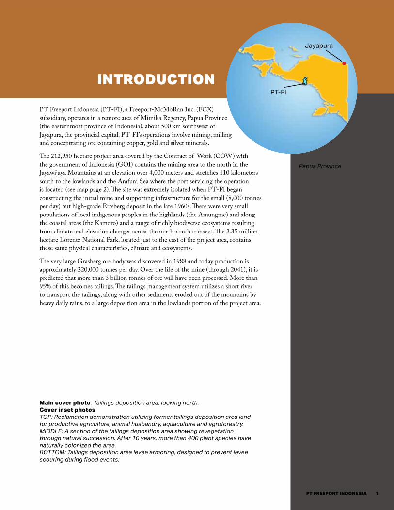
PT Freeport Indonesia (PT-FI), a Freeport-McMoRan Inc. (FCX) subsidiary, operates in a remote area of Mimika Regency, Papua Province (the easternmost province of Indonesia), about 500 km southwest of Jayapura, the provincial capital. PT-FI’s operations involve mining, milling and concentrating ore containing copper, gold and silver minerals.
The 212,950 hectare project area covered by the Contract of Work (COW) with the government of Indonesia (GOI) contains the mining area to the north in the Jayawijaya Mountains at an elevation over 4,000 meters and stretches 110 kilometers south to the lowlands and the Arafura Sea where the port servicing the operation is located (see map page 2). The site was extremely isolated when PT-FI began constructing the initial mine and supporting infrastructure for the small (8,000 tonnes per day) but high-grade Ertsberg deposit in the late 1960s. There were very small populations of local indigenous peoples in the highlands (the Amungme) and along the coastal areas (the Kamoro) and a range of richly biodiverse ecosystems resulting from climate and elevation changes across the north-south transect. The 2.35 million hectare Lorentz National Park, located just to the east of the project area, contains these same physical characteristics, climate and ecosystems.
The very large Grasberg ore body was discovered in 1988 and today production is approximately 220,000 tonnes per day. Over the life of the mine (through 2041), it is predicted that more than 3 billion tonnes of ore will have been processed. More than 95% of this becomes tailings. The tailings management system utilizes a short river to transport the tailings, along with other sediments eroded out of the mountains by heavy daily rains, to a large deposition area in the lowlands portion of the project area.
CONTROLLED RIVERINE TAILINGS MANAGEMENT AT PT FREEPORT INDONESIA
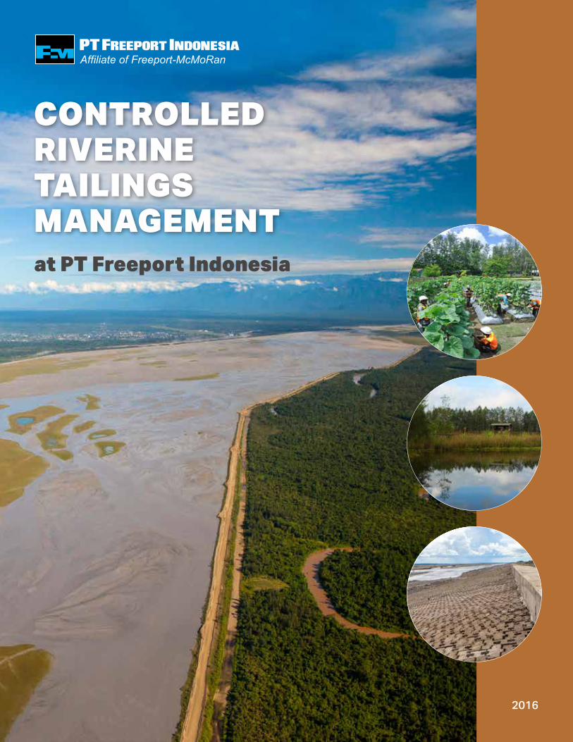
Main cover photo: Tailings deposition area, looking north.Cover inset photos TOP: Reclamation demonstration utilizing former tailings deposition area land for productive agriculture, animal husbandry, aquaculture and agroforestry. MIDDLE: A section of the tailings deposition area showing revegetation through natural succession. After 10 years, more than 400 plant species have naturally colonized the area. BOTTOM: Tailings deposition area levee armoring, designed to prevent levee scouring during flood events.
PT-FI
Jayapura
1PT FREEPORT INDONESIA

2

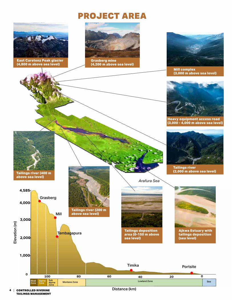
PHYSICAL ENVIRONMENTPT-FI’s project area extends to the highest point on the island, Puncak Jaya (also known as Carstenz Pyramid or Nemangkawi), in the Jayawijaya Mountains, a central mountain chain that lies along the active collision zone of two tectonic plates. Mountains in the immediate area of the mine rise to over 4,800 meters with elevations presently increasing 4-6 centimeters a year. Some of these mountains are capped with glaciers, even though the locality is just 4 degrees south of the equator. The area is characterized by extremely rugged terrain and is seismically active.
Changes in elevation are drastic as the mountain peaks fall to the piedmont only a few hundred meters above sea level in just 50 kilometers of linear distance. Rainfall is high, with annual amounts exceeding 12 meters in some areas. Rivers flow through very narrow valleys as deep as 1,000 m, with steep gradients ranging from 40 degrees to near vertical faces. With the extremely high rainfall in the mountains, flash flooding is common, resulting in high rates of erosion and valley wall instability. This has created a lowland area of unconsolidated sediments that slope gradually from the piedmont hills for about 80 km to the Arafura Sea on the southern coast (see photos and diagrams on p 4).
Climate and elevation changes over the north-south transect from the mine to the portsite have produced richly biodiverse ecosystems that range from alpine ecosystems at 3,000 m elevation and above, to montane cloud and rainforests, descending to lowland tropical heath, coastal palm and mangrove forests and estuarine ecosystems at sea level. The area includes the PT-FI operations and supporting infrastructure including a seaport, power plant, materials logistics yard. Additionally there are two company towns, an airport and hotel facility; and the local town of Timika. Timika, which did not exist before operations began, has grown in parallel with the PT-FI operation and is now the capital of the Mimika Regency. Today, more than 200,000 people live in the lowland area.
3PT FREEPORT INDONESIA
Concentrator facility in the mountains.
Ajkwa Estuary with tailings deposition (sea level)
Grasberg mine (4,200 m above sea level)
East Carstenz Peak glacier (4,800 m above sea level)
Elev
atio
n (m
)
Grasberg
Mill
PROJECT AREA
Arafura Sea
Mill complex(3,000 m above sea level)
Heavy equipment access road(3,000 - 4,000 m above sea level)
Tailings river(2,000 m above sea level)
Tailings deposition area (0-150 m above sea level)
Tailings river (200 m above sea level)
Tailings river (400 m above sea level)
Tembagapura
Timika
4,585
2,000
1,000
Portsite
Nival Zone
Alpine Zone
Sub Alpine Zone
Montane Zone Lowland Zone Sea
Distance (km)
4,000
3,000
4 CONTROLLED RIVERINE TAILINGS MANAGEMENT
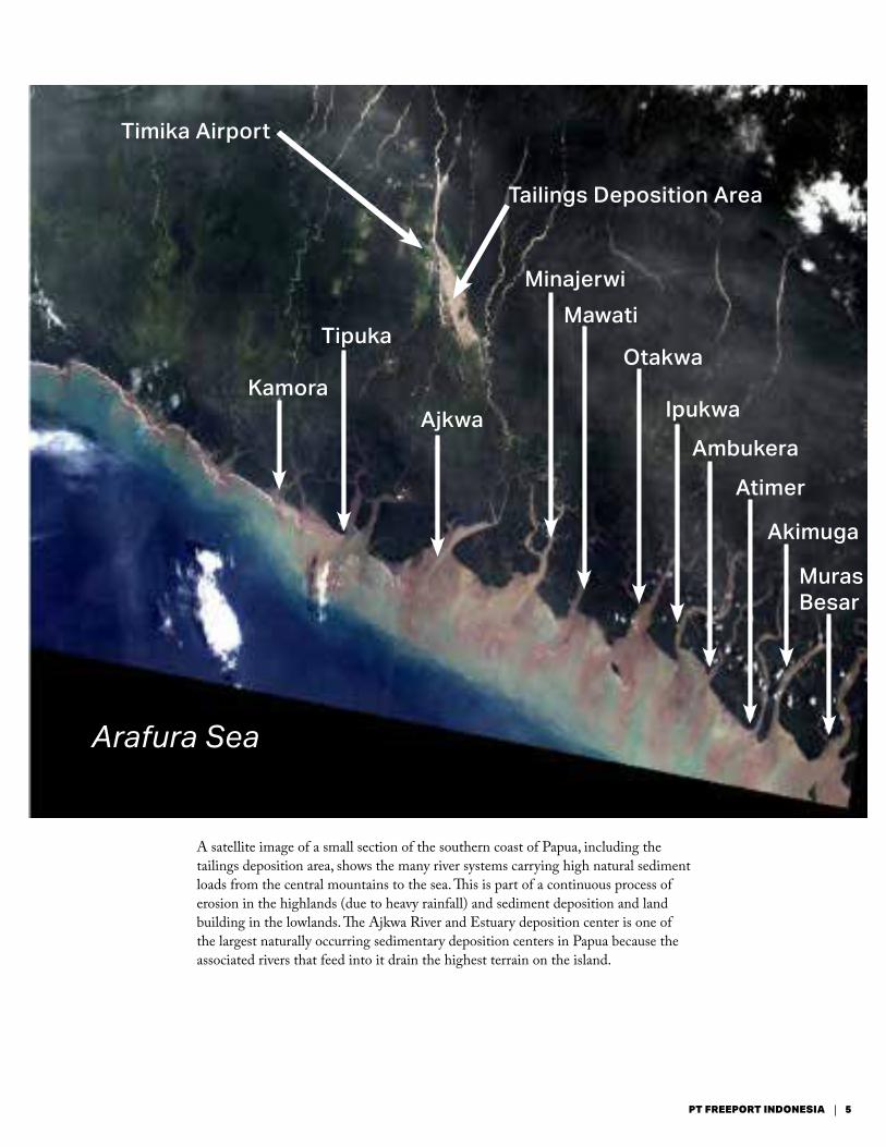
A satellite image of a small section of the southern coast of Papua, including the tailings deposition area, shows the many river systems carrying high natural sediment loads from the central mountains to the sea. This is part of a continuous process of erosion in the highlands (due to heavy rainfall) and sediment deposition and land building in the lowlands. The Ajkwa River and Estuary deposition center is one of the largest naturally occurring sedimentary deposition centers in Papua because the associated rivers that feed into it drain the highest terrain on the island.
Timika Airport
Kamora
Tipuka
Ajkwa
MinajerwiMawati
Otakwa
Ipukwa
Ambukera
Atimer
Akimuga
Muras Besar
Arafura Sea
Tailings Deposition Area
5PT FREEPORT INDONESIA

WHAT ARE TAILINGS?Mine tailings are the finely ground natural rock particles that remain after the commercially valuable minerals have been separated and removed from the ore.
At PT-FI, ore containing copper, gold and silver minerals is sent to a milling/concentrating facility 3 kilometers south of the mining area in a valley 1,000 meters lower in elevation. Milling is a physical process, where the ore is crushed and ground to a size consistent with fine sand and mixed with water to produce a slurry. Concentrating is done using a flotation process. Two kilograms of lime per tonne of ore are added to the slurry to increase the pH to a level that allows the flotation reagents, added to a concentration of approximately 100 parts per million, to work efficiently. Air is injected into this slurry in a series of tanks. The copper and precious metal minerals bind with the reagents and float to the surface of the slurry with the injected air bubbles, separating the commercial minerals from the rock particles that do not have value (see illustration below). This froth of mineral particles is known as concentrate. The majority of the flotation reagents report with the concentrate. The very small reagent concentration remaining in tailings is well below the threshold set by the United Nations General Harmonized System for Classification and Labeling of Chemicals for acute or chronic aquatic toxicity.
The remaining finely ground rock particles – the tailings – settle to the bottom of the processing tanks and are then transported via the controlled riverine tailings system to the tailings deposition area in the lowlands. The concentrate is sent via pipeline to the port facility near the Arafura Sea, approximately 110 km to the south, where it is dried and prepared for shipment to customers.
Froth FlotationEconomic Mineral Separation Process
Grasberg Mill Complex
ground ore is placed in flotation tanks
add water
add lime
add reagent*
* REAGENT’S JOB• economic mineral
collector
• foaming agent
air is pumped into the flotation tanksnon-economic minerals
economic minerals float out
non-economic minerals settle to
bottom
concentrate
tailings
tailings deposition area
portsite
rec
lam
atio
nsm
elte
r
copper, gold, silver
6

Mine
Project Area
TAILINGS MANAGEMENT STUDIES AND APPROVAL
PT-FI uses a controlled riverine tailings management system that transports the tailings out of the highlands to a designated area in the lowlands and coastal zone. The river, located in a very narrow, steep valley, also carries high natural sediment loads from rain runoff and erosion. It is not navigable and is not used for potable water, agriculture, fishing or other domestic or commercial uses, nor was it used for these purposes before operations began. The tailings deposition area is a portion of the river’s flood plain in the lowlands. PT-FI has designed and constructed a system of levees to manage the deposition of what will ultimately be about 3 billion tonnes of tailings within the designated terrestrial area and associated estuary (see map below).
TAILINGS MANAGEMENT ALTERNATIVES The tailings management system at PT-FI must be able to handle the 3 billion tonnes of tailings expected to be produced over the life of the mine through 2041 and allow for the impacts to be minimized and managed. The controlled riverine tailings management
system was selected from a series of alternatives studied over a period of years by internal and external experts in the field. Both PT-FI and third parties have reviewed this selection multiple times and internationally recognized experts in environmental management issues, including Montgomery Watson Harza, Dames & Moore and Applied Research Affiliate of Bandung Institute of Technology (LAPI/ITB), have conducted independent environmental audits every three years since 1996. These reviews and audits have consistently reaffirmed that the selected tailings management system is the best site-specific alternative, considering the topographical, seismic and geotechnical, geological, climatological and environmental conditions of the project area.
More than a dozen alternatives for managing tailings were evaluated. They can be grouped into four general categories: conventional high-wall storage in the highland or midland valleys; ring dam storage in the lowlands; pipelines with sub-aqueous disposal; and riverine transport with run-of-river deposition.
CONTROLLED RIVERINE TAILINGS MANAGEMENT SYSTEM
High rainfall and steep slopes create local rivers with elevated natural sediment loads.
Timika Airport
Mill
Tailings riverControlled riverine tailings transport
Ajkwa River
Timika PT-FI logistic road
West levee
East levee
Portsite
Planned levee extension
Tailings deposition area (230 km2)
Estuary portion of tailings deposition area (220 km2)
7PT FREEPORT INDONESIA
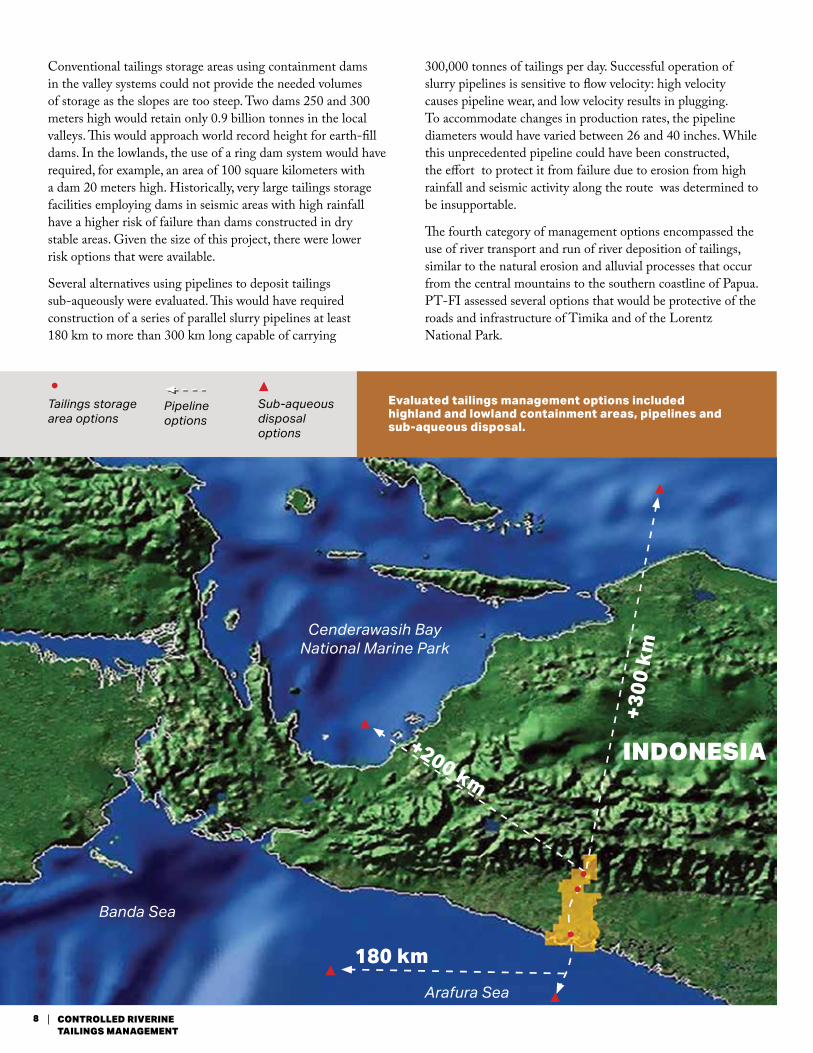
Conventional tailings storage areas using containment dams in the valley systems could not provide the needed volumes of storage as the slopes are too steep. Two dams 250 and 300 meters high would retain only 0.9 billion tonnes in the local valleys. This would approach world record height for earth-fill dams. In the lowlands, the use of a ring dam system would have required, for example, an area of 100 square kilometers with a dam 20 meters high. Historically, very large tailings storage facilities employing dams in seismic areas with high rainfall have a higher risk of failure than dams constructed in dry stable areas. Given the size of this project, there were lower risk options that were available.
Several alternatives using pipelines to deposit tailings sub-aqueously were evaluated. This would have required construction of a series of parallel slurry pipelines at least 180 km to more than 300 km long capable of carrying
300,000 tonnes of tailings per day. Successful operation of slurry pipelines is sensitive to flow velocity: high velocity causes pipeline wear, and low velocity results in plugging. To accommodate changes in production rates, the pipeline diameters would have varied between 26 and 40 inches. While this unprecedented pipeline could have been constructed, the effort to protect it from failure due to erosion from high rainfall and seismic activity along the route was determined to be insupportable.
The fourth category of management options encompassed the use of river transport and run of river deposition of tailings, similar to the natural erosion and alluvial processes that occur from the central mountains to the southern coastline of Papua. PT-FI assessed several options that would be protective of the roads and infrastructure of Timika and of the Lorentz National Park.
Cenderawasih Bay National Marine Park
Banda Sea
Arafura Sea
INDONESIA
180 km
+200 km
+300
km
Evaluated tailings management options included highland and lowland containment areas, pipelines and sub-aqueous disposal.
Tailings storage area options
Sub-aqueous disposal options
Pipeline options
8 CONTROLLED RIVERINE TAILINGS MANAGEMENT
INDONESIA
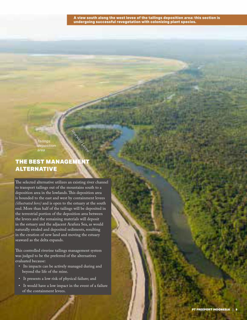
THE BEST MANAGEMENT ALTERNATIVE
The selected alternative utilizes an existing river channel to transport tailings out of the mountains south to a deposition area in the lowlands. This deposition area is bounded to the east and west by containment levees (illustrated here) and is open to the estuary at the south end. More than half of the tailings will be deposited in the terrestrial portion of the deposition area between the levees and the remaining materials will deposit in the estuary and the adjacent Arafura Sea, as would naturally eroded and deposited sediments, resulting in the creation of new land and moving the estuary seaward as the delta expands.
This controlled riverine tailings management system was judged to be the preferred of the alternatives evaluated because:
• Its impacts can be actively managed during and beyond the life of the mine.
• It presents a low risk of physical failure; and
• It would have a low impact in the event of a failure of the containment levees.
Tailings deposition area
New west Levee
A view south along the west levee of the tailings deposition area: this section is undergoing successful revegetation with colonizing plant species.
9PT FREEPORT INDONESIA

1991 The Government of Indonesia provided the legal authority for PT-FI to use the
land known as the project area (stretching down a corridor from the existing mine area to the Arafura Sea), which was required for the development of the ore deposits and associated processing and support operations, including the tailings deposition area, through a Contract of Work (and the earlier 1967 COW).
1992 PT-FI investigated the technical feasibility of transporting tailings via pipeline to an
offshore disposal site in the Arafura Sea. The consultant concluded that while the design of the pipeline could theoretically be based on existing technology, no tailings slurry pipelines had been constructed with the combination of capacity, elevation drop, and length that would be required. PT-FI assessed the project to have unacceptable engineering and environmental risks.
1994 In an Alternative Tailings Management Study, a consultant reviewed alternatives
for tailings deposition in the lowlands. After evaluation of the associated risks and potential impacts, the construction a floodplain management and delta formation system defined by a man-made boundary within which the tailings and sediments would be transported and deposited as the river flowed to the estuary and eventually to the sea was recommended.
• The Environmental Impact Analysis Report (Indonesian ANDAL) provided a review of all of the tailings management alternatives evaluated up to that time and came to the same conclusion as the previous studies: river transport, floodplain management and delta formation was the preferred alternative.
• The GOI approved the controlled riverine tailings management system in association with an increase in ore production to 160,000 tonnes per day.
1995 - 1996 The Governor of Papua issued
Provincial permits for the approved tailings management system.
1995 - 1997 The Conceptual Tailings Option
study assessed the tailings management system in use at the time and provided additional review of alternative management systems. The objective was to identify and recommend changes to the existing tailings management practices to accommodate further increases in reserves and production. The study concluded that PT-FI should continue to use the controlled riverine tailings management system with an expanded deposition area (illustrated opposite).
1997 An Environmental Impact Analysis Report (ANDAL), complemented with an
Environmental Impact Management (RKL) and Monitoring Plan (RPL) was presented to the GOI using the conclusions from the Conceptual Tailings Options study related to tailings management.
The GOI approved an expansion of the size of the deposition area, based on an increase in ore reserves to 3 billion tonnes and an increase of ore production and processing to a maximum of 300,000 tonnes per day.
1999 The GOI Forestry Department issued a Borrow-to-Use permit for the land area
required for tailings deposition and management.
2002 An Environmental Risk Assessment (ERA) related to the potential for
additional impacts of the tailings management system on human health, aquatic ecosystems and plant/wildlife was presented to the GOI. The ERA concluded that the impacts had been properly evaluated in the ANDAL, and made recommendations for designing a long-term monitoring program.
2005 The Mimika Regent issued approval of the tailings management system and a
local permit for the designation and utilization of a local river system in Mimika Regency for tailings transport and deposition.
2008 The GOI Minister of Environment issued a decree specifically addressing conditions
for the management of PT-FI tailings. The decree regulates the quantity of tailings and natural sediments and the quality of water that can pass through the tailings deposition area and into the estuary and Arafura Sea.
2012 The Mimika Regent, the Governor of Papua and PT-FI signed an agreement
relating to development of tailings as a construction material for the sustainable development of the region.
TAILINGS MANAGEMENT APPROVALS
10 CONTROLLED RIVERINE TAILINGS MANAGEMENT

Tailings deposition area
Reclamation area
Ajkwa River
Old west levee
New west levee
2014 The GOI passed legislation classifying tailings as a high-volume,
low-toxicity material. As required, PT-FI has submitted a request to the GOI for a modified tailings deposition permit. There are opportunities for de-classification based on the results of hazardous characteristics testing, which are presently in progress.
summary While the tailings management system
has all of the required approvals, PT-FI continues to evaluate ways to reduce the impacts. These activities are documented in the Environmental Management System, which is certified to ISO 14001 and in annual internal environmental audits for the FCX Board of Directors. Also, external environmental audits have been conducted every three years since 1996. The findings and action plans for the more recent external audits are available at fcx.com/sd.
11PT FREEPORT INDONESIA
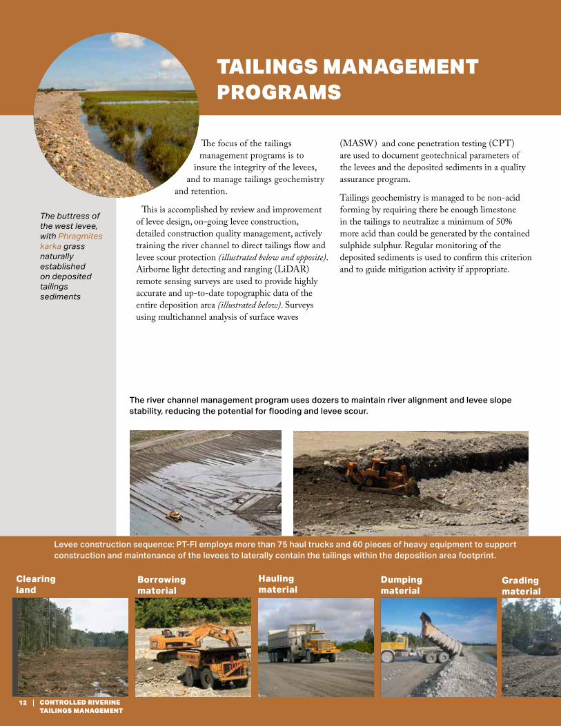
TAILINGS MANAGEMENT PROGRAMS
The focus of the tailings management programs is to
insure the integrity of the levees, and to manage tailings geochemistry
and retention.
This is accomplished by review and improvement of levee design, on-going levee construction, detailed construction quality management, actively training the river channel to direct tailings flow and levee scour protection (illustrated below and opposite). Airborne light detecting and ranging (LiDAR) remote sensing surveys are used to provide highly accurate and up-to-date topographic data of the entire deposition area (illustrated below). Surveys using multichannel analysis of surface waves
(MASW) and cone penetration testing (CPT) are used to document geotechnical parameters of the levees and the deposited sediments in a quality assurance program.
Tailings geochemistry is managed to be non-acid forming by requiring there be enough limestone in the tailings to neutralize a minimum of 50% more acid than could be generated by the contained sulphide sulphur. Regular monitoring of the deposited sediments is used to confirm this criterion and to guide mitigation activity if appropriate.
Levee construction sequence: PT-FI employs more than 75 haul trucks and 60 pieces of heavy equipment to support construction and maintenance of the levees to laterally contain the tailings within the deposition area footprint.
Clearing land
Borrowing material
Hauling material
Gradingmaterial
Dumping material
The river channel management program uses dozers to maintain river alignment and levee slope stability, reducing the potential for flooding and levee scour.
The buttress of the west levee, with Phragmites karka grass naturally established on deposited tailings sediments
12 CONTROLLED RIVERINE TAILINGS MANAGEMENT

Raising levee height
Gradingmaterial
Compacting levee embankment
Verifying levee stiffness
Maintaining levee road
Levee
Reno mattress
Stabilizing toe
Reno mattress Levee armoring construction Stabilizing toe
The levees that contain the tailings deposition area are armored at key locations using Reno mattresses to prevent levee scouring during flood events.
13PT FREEPORT INDONESIA
Levee armoring using Reno mattresses to prevent toe scouring during flood events.
Mangroves Phragmites karka grass Vetiver grass
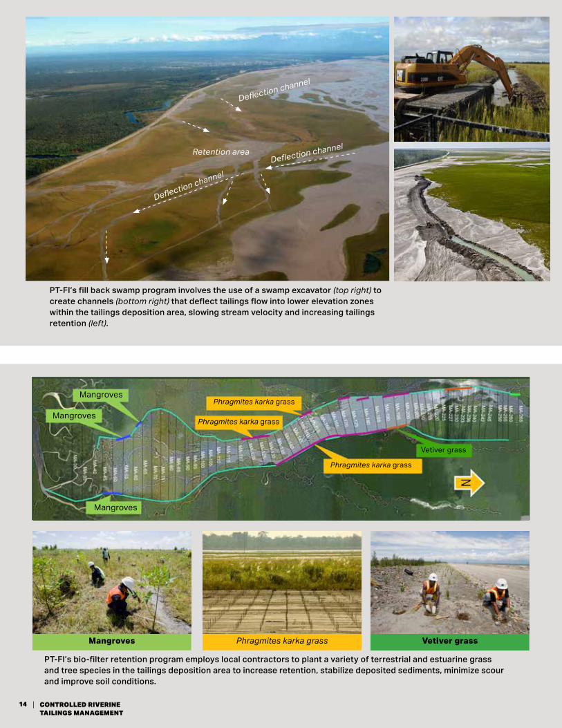
PT-FI’s bio-filter retention program employs local contractors to plant a variety of terrestrial and estuarine grass and tree species in the tailings deposition area to increase retention, stabilize deposited sediments, minimize scour and improve soil conditions.
Deflection channel
Retention areaDeflection channel
Deflection channel
PT-FI’s fill back swamp program involves the use of a swamp excavator (top right) to create channels (bottom right) that deflect tailings flow into lower elevation zones within the tailings deposition area, slowing stream velocity and increasing tailings retention (left).
Mangroves
Mangroves
Mangroves
Phragmites karka grass
Vetiver grass
Phragmites karka grass
Phragmites karka grass
14 CONTROLLED RIVERINE TAILINGS MANAGEMENT
Sediment Deposition 1997 to 2015
Observed SimulatedMeters of deposition
0 0 - 0.5 0.5 - 1.0 1.0 - 1.51.5 - 2.0 2.0 - 2.51.5 - 3.53.5 - 4.04.0 - 4.54.5 - 5.05.0 - 5.55.5 - 6.06.0 - 6.5 6.5 - 7.0
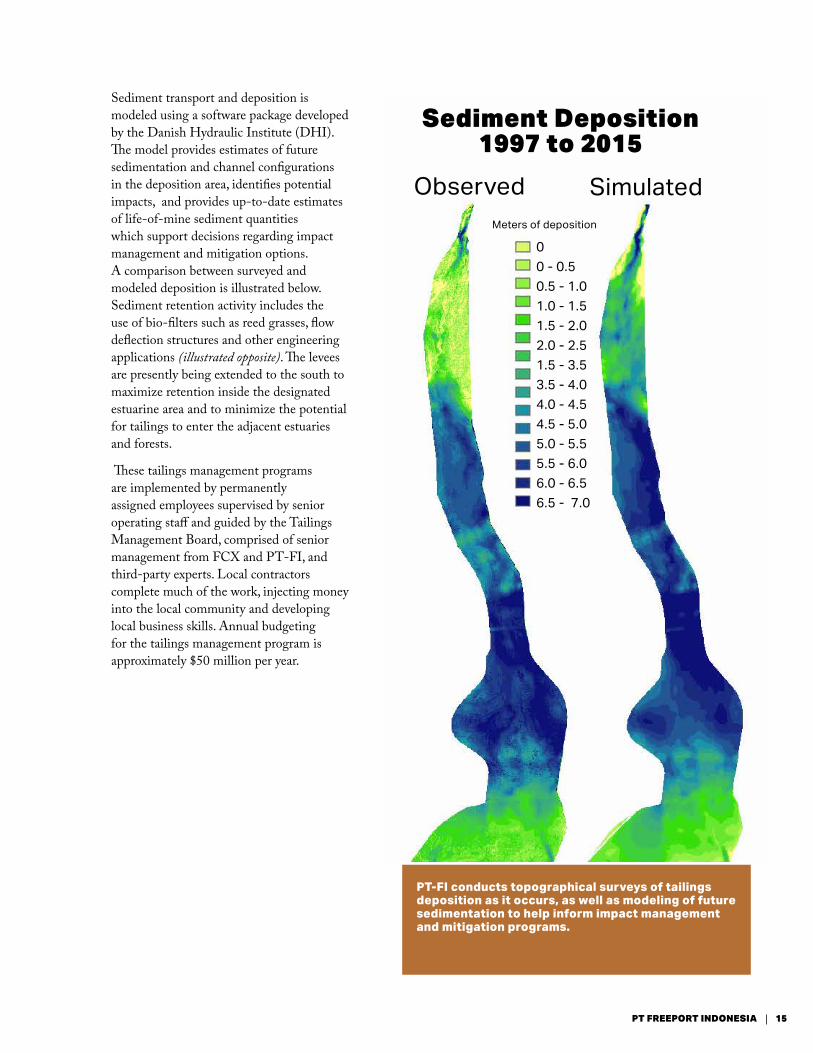
Sediment transport and deposition is modeled using a software package developed by the Danish Hydraulic Institute (DHI). The model provides estimates of future sedimentation and channel configurations in the deposition area, identifies potential impacts, and provides up-to-date estimates of life-of-mine sediment quantities which support decisions regarding impact management and mitigation options. A comparison between surveyed and modeled deposition is illustrated below. Sediment retention activity includes the use of bio-filters such as reed grasses, flow deflection structures and other engineering applications (illustrated opposite). The levees are presently being extended to the south to maximize retention inside the designated estuarine area and to minimize the potential for tailings to enter the adjacent estuaries and forests.
These tailings management programs are implemented by permanently assigned employees supervised by senior operating staff and guided by the Tailings Management Board, comprised of senior management from FCX and PT-FI, and third-party experts. Local contractors complete much of the work, injecting money into the local community and developing local business skills. Annual budgeting for the tailings management program is approximately $50 million per year.
PT-FI conducts topographical surveys of tailings deposition as it occurs, as well as modeling of future sedimentation to help inform impact management and mitigation programs.
15PT FREEPORT INDONESIA
ENVIRONMENTAL IMPACTS
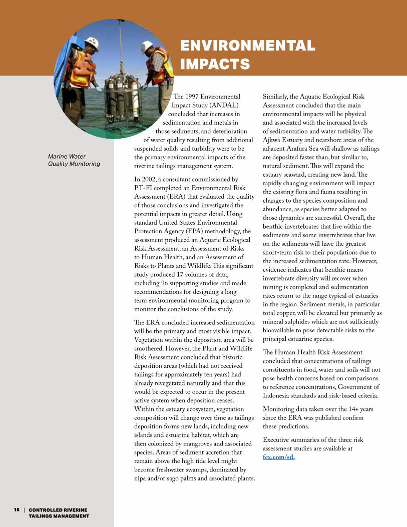
Marine Water Quality Monitoring
The 1997 Environmental Impact Study (ANDAL)
concluded that increases in sedimentation and metals in
those sediments, and deterioration of water quality resulting from additional
suspended solids and turbidity were to be the primary environmental impacts of the riverine tailings management system.
In 2002, a consultant commissioned by PT-FI completed an Environmental Risk Assessment (ERA) that evaluated the quality of those conclusions and investigated the potential impacts in greater detail. Using standard United States Environmental Protection Agency (EPA) methodology, the assessment produced an Aquatic Ecological Risk Assessment, an Assessment of Risks to Human Health, and an Assessment of Risks to Plants and Wildlife. This significant study produced 17 volumes of data, including 96 supporting studies and made recommendations for designing a long-term environmental monitoring program to monitor the conclusions of the study.
The ERA concluded increased sedimentation will be the primary and most visible impact. Vegetation within the deposition area will be smothered. However, the Plant and Wildlife Risk Assessment concluded that historic deposition areas (which had not received tailings for approximately ten years) had already revegetated naturally and that this would be expected to occur in the present active system when deposition ceases. Within the estuary ecosystem, vegetation composition will change over time as tailings deposition forms new lands, including new islands and estuarine habitat, which are then colonized by mangroves and associated species. Areas of sediment accretion that remain above the high tide level might become freshwater swamps, dominated by nipa and/or sago palms and associated plants.
Similarly, the Aquatic Ecological Risk Assessment concluded that the main environmental impacts will be physical and associated with the increased levels of sedimentation and water turbidity. The Ajkwa Estuary and nearshore areas of the adjacent Arafura Sea will shallow as tailings are deposited faster than, but similar to, natural sediment. This will expand the estuary seaward, creating new land. The rapidly changing environment will impact the existing flora and fauna resulting in changes to the species composition and abundance, as species better adapted to those dynamics are successful. Overall, the benthic invertebrates that live within the sediments and some invertebrates that live on the sediments will have the greatest short-term risk to their populations due to the increased sedimentation rate. However, evidence indicates that benthic macro-invertebrate diversity will recover when mining is completed and sedimentation rates return to the range typical of estuaries in the region. Sediment metals, in particular total copper, will be elevated but primarily as mineral sulphides which are not sufficiently bioavailable to pose detectable risks to the principal estuarine species.
The Human Health Risk Assessment concluded that concentrations of tailings constituents in food, water and soils will not pose health concerns based on comparisons to reference concentrations, Government of Indonesia standards and risk-based criteria.
Monitoring data taken over the 14+ years since the ERA was published confirm these predictions.
Executive summaries of the three risk assessment studies are available at fcx.com/sd.
16 CONTROLLED RIVERINE TAILINGS MANAGEMENT
PT Freeport IndonesiaAffiliate of Freeport-McMoRan
Laboratory analysis of samples
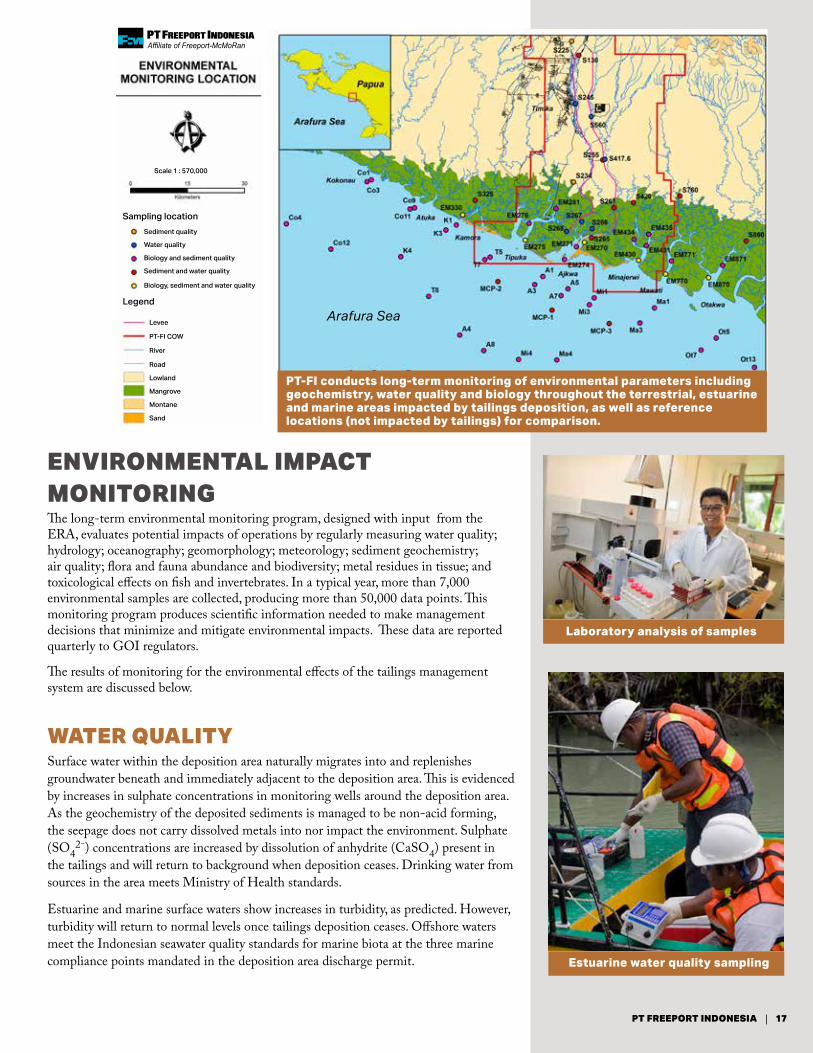
ENVIRONMENTAL IMPACT MONITORING The long-term environmental monitoring program, designed with input from the ERA, evaluates potential impacts of operations by regularly measuring water quality; hydrology; oceanography; geomorphology; meteorology; sediment geochemistry; air quality; flora and fauna abundance and biodiversity; metal residues in tissue; and toxicological effects on fish and invertebrates. In a typical year, more than 7,000 environmental samples are collected, producing more than 50,000 data points. This monitoring program produces scientific information needed to make management decisions that minimize and mitigate environmental impacts. These data are reported quarterly to GOI regulators.
The results of monitoring for the environmental effects of the tailings management system are discussed below.
WATER QUALITYSurface water within the deposition area naturally migrates into and replenishes groundwater beneath and immediately adjacent to the deposition area. This is evidenced by increases in sulphate concentrations in monitoring wells around the deposition area. As the geochemistry of the deposited sediments is managed to be non-acid forming, the seepage does not carry dissolved metals into nor impact the environment. Sulphate (SO4
2-) concentrations are increased by dissolution of anhydrite (CaSO4) present in the tailings and will return to background when deposition ceases. Drinking water from sources in the area meets Ministry of Health standards.
Estuarine and marine surface waters show increases in turbidity, as predicted. However, turbidity will return to normal levels once tailings deposition ceases. Offshore waters meet the Indonesian seawater quality standards for marine biota at the three marine compliance points mandated in the deposition area discharge permit. Estuarine water quality sampling
Arafura Sea
Sampling location
Legend
Sediment quality
Levee
PT-FI COW
River
Road
Lowland
Mangrove
Montane
Sand
Scale 1 : 570,000
Water quality
Biology and sediment quality
Sediment and water quality
Biology, sediment and water quality
PT-FI conducts long-term monitoring of environmental parameters including geochemistry, water quality and biology throughout the terrestrial, estuarine and marine areas impacted by tailings deposition, as well as reference locations (not impacted by tailings) for comparison.
17PT FREEPORT INDONESIA

Sediment and benthos sampling
Fish sampling catch
Fish sampling with gillnets
Fish sampling with trawler
Mangrove growth monitoring
SEDIMENTATIONChanges caused by tailings in the sedimentation patterns in the estuary are resulting in changes to the local aquatic habitat and stresses to the flora and fauna in those areas. Routine monitoring and special studies document changes in species but indicate a functioning ecosystem comparable to adjacent unimpacted estuaries.
AQUATIC FAUNA COMMUNITYPT-FI’s aquatic biological monitoring program samples aquatic communities at more than 200 locations to assess biodiversity, abundance and biomass of nekton, benthos and plankton. Extensive studies of estuarine benthos have tracked the predicted localized short-term decrease in benthos diversity as a result of the physical impacts of increased sedimentation rates and turbidity. However, monitoring also demonstrates an overall functioning ecosystem with only minor changes in the fish and their invertebrate prey.
FAUNA TISSUE TOXICOLOGYEach year, PT-FI collects and assays 125 samples of aquatic animal tissue from tailings impacted areas and non-impacted reference locations, providing over 1,000 data points. Results of current monitoring show that fish and crustacea from the tailings estuary are suitable for consumption, as regulated by Government of Indonesia food standards.
PT-FI also regularly monitors metal content in a variety of agricultural crops grown on tailings soils. Each year, more than 40 different species of agricultural plants are grown and analyzed for the content of arsenic, copper, mercury, lead and zinc. All arsenic and lead results are below detection limits and other metals are well below applicable limits for safe consumption. These results continue to show the viability of using reclaimed tailings areas for agricultural production.
TOXICITYAnnual acute toxicity tests of surface water from the deposition area have not identified toxicity to local fish species. Sediments collected within the estuary portion of the deposition area indicate moderate adverse effects to a sensitive local species of amphipod. Special studies are ongoing to identify the cause(s). Toxicity bioassays of sediments collected from the marine environment do not indicate any toxicity to the amphipods.
18 CONTROLLED RIVERINE TAILINGS MANAGEMENT
Revegetation within the tailings deposition area
East levee
New west levee Tailings deposition area
Reclamation area
Ajkwa River
Old west levee
EVIDENCE OF RECOVERY
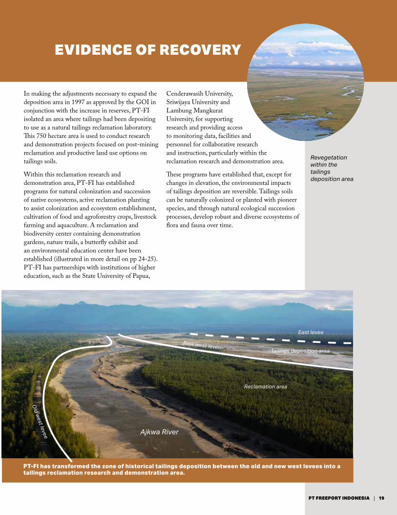
In making the adjustments necessary to expand the deposition area in 1997 as approved by the GOI in conjunction with the increase in reserves, PT-FI isolated an area where tailings had been depositing to use as a natural tailings reclamation laboratory. This 750 hectare area is used to conduct research and demonstration projects focused on post-mining reclamation and productive land use options on tailings soils.
Within this reclamation research and demonstration area, PT-FI has established programs for natural colonization and succession of native ecosystems, active reclamation planting to assist colonization and ecosystem establishment, cultivation of food and agroforestry crops, livestock farming and aquaculture. A reclamation and biodiversity center containing demonstration gardens, nature trails, a butterfly exhibit and an environmental education center have been established (illustrated in more detail on pp 24-25). PT-FI has partnerships with institutions of higher education, such as the State University of Papua,
Cenderawasih University, Sriwijaya University and Lambung Mangkurat University, for supporting research and providing access to monitoring data, facilities and personnel for collaborative research and instruction, particularly within the reclamation research and demonstration area.
These programs have established that, except for changes in elevation, the environmental impacts of tailings deposition are reversible. Tailings soils can be naturally colonized or planted with pioneer species, and through natural ecological succession processes, develop robust and diverse ecosystems of flora and fauna over time.
PT-FI has transformed the zone of historical tailings deposition between the old and new west levees into a tailings reclamation research and demonstration area.
19PT FREEPORT INDONESIA

Natural ecological succession in the tailings deposition area
TERRESTRIAL RECOVERY
Deposited tailings initially contain low soil nutrients and organic carbon, but natural ecological succession begins rapidly in the terrestrial portion of the tailings deposition area, with the native Phragmites karka grass as a pioneer colonizer. This tall reed grass produces large amounts of organic matter which enriches tailings sediment and improves its water retention capacity, enabling other species to more readily colonize the tailings as well. With time, soil microclimate, microorganisms and nutrient levels in the tailings soils improve, allowing more species to propagate. The diversity of terrestrial flora and fauna increases, with a mature climax community developing within several decades (illustrated on left). Environmental staff have studied the advantages of assisting in this process by planting and turning under legume cover crops and trees such as casuarina that fix their nitrogen requirements from the atmosphere, adding important nutrients to the soil.
A Natural Succession and Discovery Park has been established within the reclamation and demonstration area. This is an area where historic tailings deposits are undergoing natural colonization and succession by native flora and fauna species. Employees have monitored this area over time to determine the rate and trajectory of natural succession, and to understand the mechanisms of terrestrial ecosystem recovery in tailings deposition areas. Researchers from the State University of Papua have also studied natural colonization and succession on deposited tailings. They recorded 27 plant species in 1995, 274 in 2002 and 506 in 2005. The study concluded that in less than 20 years, succession had reached the stage of young secondary forest. One hundred and fifty eight bird species, 42 species of amphibians and reptiles, 93 butterfly species and 10 mammalian species have been identified in this area.
As well as providing a natural laboratory for monitoring and research, today the Natural Succession Discovery Park serves as a conservation education and demonstration tool for stakeholders and students (illustrated on p 24 and 25).
ESTUARINE RECOVERY
Rapid rates of sedimentation occur in the Ajkwa Estuary that receives both natural sediments and a fraction of tailings not captured in the terrestrial section of the tailings deposition area. This sedimentation has created Ajkwa Island where native species first appeared in 1996 through natural ecological succession processes. Plant species composition and maturity have continued to increase with time even as the island changes shape in response to natural sedimentation and erosion processes. Monitoring surveys have recorded some nine species of mangrove, 20 crustacean species, four mollusk species and 23 families of polychaetes (segmented worms) inhabiting Ajkwa Island. Similar colonization is occurring on the more recently formed Waii Island where environmental staff have successfully transplanted mangroves to assist in land stabilization and to study the advantages and disadvantages of assisted colonization. Both natural and assisted colonization are occurring on other tailings land formations within the Ajkwa Estuary.
Freshly deposited tailings sediments
0-2 years: Phragmites karka grass
After 2-3 years: shrubs and ferns
After 6-10 years: pole saplings
After 10 years: young forest
20-30 years: mature forest
20 CONTROLLED RIVERINE TAILINGS MANAGEMENT

Mangrove Colonization in the Ajkwa Estuary at Waii Island Colonization of grasses and palms in the upper Ajkwa Estuary
Ajkwa Island Waii Island
Ajkwa Island has been developing since 1997 Natural succession of mangrove community in Ajkwa Estuary
PT-FI routinely monitors and researches natural colonization of both flora and fauna on tailings sediments deposited in the Ajkwa Estuary, including on the new landforms, Ajkwa Island and Waii Island.
21PT FREEPORT INDONESIA
MINAJERWI ESTUARYThe Minajerwi Estuary (east of the Ajkwa Estuary) received tailings sediments from 1990 to 1997, before the extended levee system excluded it from the expanded tailings deposition area. Similar to the terrestrial tailings reclamation and demonstration area, the Minajerwi Estuary has provided PT-FI with an opportunity to research ecosystem recovery in an estuary that had historically received tailings. In a detailed study conducted over 14 years, the changes in abundance and community structure of
benthos (organisms which live in the seabed) in the Minajerwi Estuary were examined. Results were compared to those in three reference estuaries using abundance, family richness, family composition, indicator families, feeding guides, diversity, evenness and similarity indices. Recovery of Minajerwi Estuary benthos communities (to states similar to that observed in reference estuaries) was indicated by some of the indices within 5 years and by most within 10 years. This type of rapid recovery of the aquatic ecosystems to conditions similar to adjacent estuaries is predicted to occur in the Ajkwa Estuary at the end of mine life.
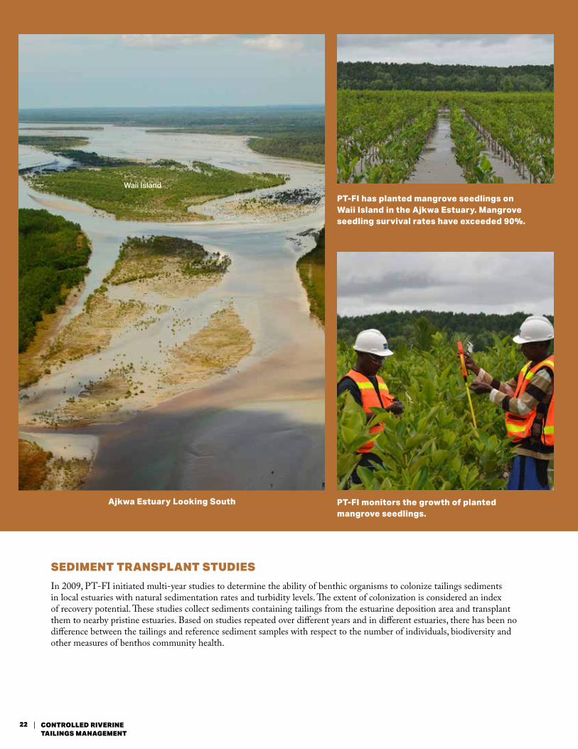
Ajkwa Estuary Looking South
PT-FI has planted mangrove seedlings on Waii Island in the Ajkwa Estuary. Mangrove seedling survival rates have exceeded 90%.
PT-FI monitors the growth of planted mangrove seedlings.
Waii Island
SEDIMENT TRANSPLANT STUDIES
In 2009, PT-FI initiated multi-year studies to determine the ability of benthic organisms to colonize tailings sediments in local estuaries with natural sedimentation rates and turbidity levels. The extent of colonization is considered an index of recovery potential. These studies collect sediments containing tailings from the estuarine deposition area and transplant them to nearby pristine estuaries. Based on studies repeated over different years and in different estuaries, there has been no difference between the tailings and reference sediment samples with respect to the number of individuals, biodiversity and other measures of benthos community health.
22 CONTROLLED RIVERINE TAILINGS MANAGEMENT
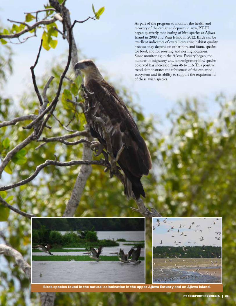
As part of the program to monitor the health and recovery of the estuarine deposition area, PT-FI began quarterly monitoring of bird species at Ajkwa Island in 2009 and Waii Island in 2012. Birds can be excellent indicators of overall estuarine habitat quality because they depend on other flora and fauna species for food, and for roosting and nesting locations. Since monitoring in the Ajkwa Estuary began, the number of migratory and non-migratory bird species observed has increased from 46 to 116. This positive trend demonstrates the robustness of the estuarine ecosystem and its ability to support the requirements of these avian species.
Birds species found in the natural colonization in the upper Ajkwa Estuary and on Ajkwa Island.
23PT FREEPORT INDONESIA
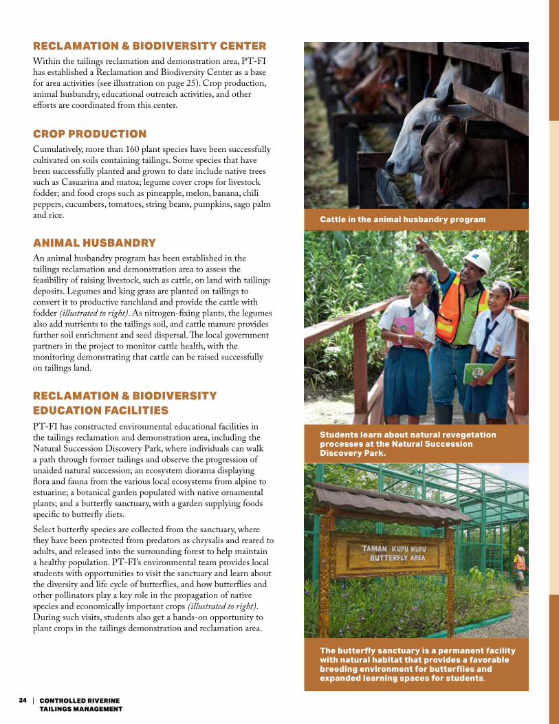
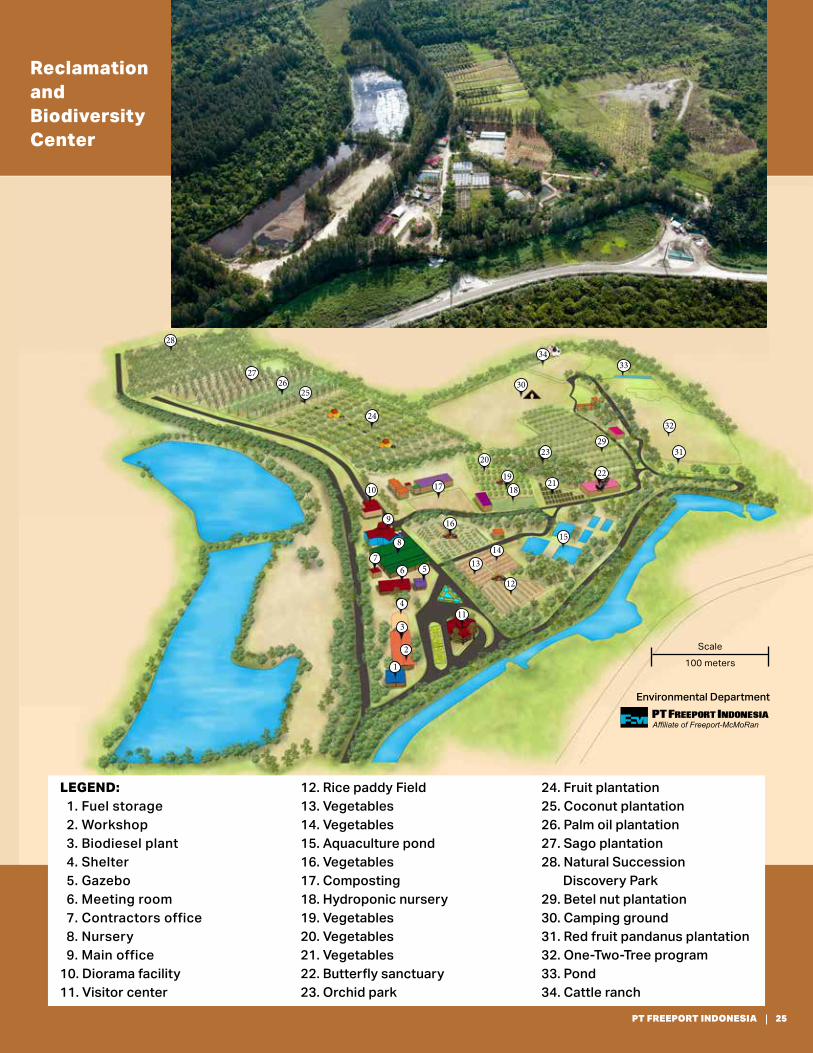
RECLAMATION & BIODIVERSITY CENTER Within the tailings reclamation and demonstration area, PT-FI has established a Reclamation and Biodiversity Center as a base for area activities (see illustration on page 25). Crop production, animal husbandry, educational outreach activities, and other efforts are coordinated from this center.
CROP PRODUCTION Cumulatively, more than 160 plant species have been successfully cultivated on soils containing tailings. Some species that have been successfully planted and grown to date include native trees such as Casuarina and matoa; legume cover crops for livestock fodder; and food crops such as pineapple, melon, banana, chili peppers, cucumbers, tomatoes, string beans, pumpkins, sago palm and rice.
ANIMAL HUSBANDRYAn animal husbandry program has been established in the tailings reclamation and demonstration area to assess the feasibility of raising livestock, such as cattle, on land with tailings deposits. Legumes and king grass are planted on tailings to convert it to productive ranchland and provide the cattle with fodder (illustrated to right). As nitrogen-fixing plants, the legumes also add nutrients to the tailings soil, and cattle manure provides further soil enrichment and seed dispersal. The local government partners in the project to monitor cattle health, with the monitoring demonstrating that cattle can be raised successfully on tailings land.
RECLAMATION & BIODIVERSITY EDUCATION FACILITIES PT-FI has constructed environmental educational facilities in the tailings reclamation and demonstration area, including the Natural Succession Discovery Park, where individuals can walk a path through former tailings and observe the progression of unaided natural succession; an ecosystem diorama displaying flora and fauna from the various local ecosystems from alpine to estuarine; a botanical garden populated with native ornamental plants; and a butterfly sanctuary, with a garden supplying foods specific to butterfly diets.Select butterfly species are collected from the sanctuary, where they have been protected from predators as chrysalis and reared to adults, and released into the surrounding forest to help maintain a healthy population. PT-FI’s environmental team provides local students with opportunities to visit the sanctuary and learn about the diversity and life cycle of butterflies, and how butterflies and other pollinators play a key role in the propagation of native species and economically important crops (illustrated to right). During such visits, students also get a hands-on opportunity to plant crops in the tailings demonstration and reclamation area.
Cattle in the animal husbandry program
The butterfly sanctuary is a permanent facility with natural habitat that provides a favorable breeding environment for butterflies and expanded learning spaces for students.
Students learn about natural revegetation processes at the Natural Succession Discovery Park.
24 CONTROLLED RIVERINE TAILINGS MANAGEMENT
Scale100 meters
PT Freeport IndonesiaAffiliate of Freeport-McMoRan
LEGEND: 1. Fuel storage 2. Workshop 3. Biodiesel plant 4. Shelter 5. Gazebo 6. Meeting room 7. Contractors office 8. Nursery 9. Main office10. Diorama facility11. Visitor center
12. Rice paddy Field13. Vegetables14. Vegetables15. Aquaculture pond16. Vegetables17. Composting18. Hydroponic nursery 19. Vegetables20. Vegetables21. Vegetables22. Butterfly sanctuary23. Orchid park
24. Fruit plantation25. Coconut plantation26. Palm oil plantation27. Sago plantation28. Natural Succession Discovery Park29. Betel nut plantation30. Camping ground31. Red fruit pandanus plantation32. One-Two-Tree program33. Pond34. Cattle ranch
Reclamation and Biodiversity Center
Environmental Department
9
8
76 5
4
3
2
1
28
2726
25
24
10 17
1615
1413
12
11
22
23
21
20
1918
32
31
3334
30
29
25PT FREEPORT INDONESIA

TAILINGS UTILIZATION IN
INFRASTRUCTURE DEVELOPMENT
As tailings are simply finely ground rock particles, there is potential for tailings to be utilized in construction materials and regional infrastructure development projects. PT-FI is collaborating with scientists from a leading Indonesian research university, Bandung Institute of Technology and its Industrial Affiliation Institute, on developing the use of tailings in the manufacture of concrete, bricks, pipes and other infrastructure products. The team has completed several infrastructure projects using tailings as a primary component of concrete. Projects include roads, public buildings and bridges in the Mimika Regency; and roads, buildings, process equipment and drainage improvements in the PT-FI project area.
PT-FI is also working with the Indonesian Ministry of Public Work and Housing and the Indonesian Agency for Assessment and Application of Technology (BPPT) to include tailings concrete in the Indonesian National Standards. This will standardize the quality of tailings products utilized in infrastructure products and potentially provide a valuable and inexpensive resource for the development of local infrastructure.
TAILINGS MANAGEMENT
COMMUNICATIONS FORUM To further encourage dialogue concerning beneficial use of tailings, PT-FI established a Tailings Management Communication Forum made up of key stakeholders from government, universities, communities and NGOs. Meetings are conducted at least every year with an agenda focusing on the status of tailings characterization, potential utilization programs and broader tailings management aspects. Participants have agreed that tailings are a potential resource for local construction activities.
INTEGRATED COASTAL ZONE MANAGEMENT PLANNING The Indonesian Government has adopted the international principles of Integrated Coastal Zone Management (ICZM) into national regulation and has tasked the Ministry of Marine and Fisheries with developing a comprehensive framework of regional coastal management plans for the country as a whole. Preparation of a Mimika coastal management plan will be their responsibility working in partnership with the Mimika Regency and other stakeholders.
In recognition of the significant interaction between PT-FI’s mining operations and the surrounding region’s coastal environments, communities, infrastructure and economy, PT-FI has developed a preliminary draft of an Integrated Coastal Management Plan that could be adapted by Mimika in collaboration with local and national GOI agencies and other stakeholders. This preliminary draft plan includes proposed zones for conservation, mining activities and other economic development opportunities (left illustration).
TAILINGS AND REGIONAL DEVELOPMENT
PT-FI donated 2,000 tailings bricks for USAID project of cold storage at Kokonao.
Tailings concrete has been used for road construction in the Mimika Regency.
26 CONTROLLED RIVERINE TAILINGS MANAGEMENT

Kamoro Village Program
COMMUNITY
LAND RIGHTS COMPENSATION Since the early beginnings of the mining operation, PT-FI has recognized the land rights of the indigenous peoples living within its project area—the Amungme in the highlands and the Kamoro in the coastal lowlands. PT-FI first compensated these peoples for use of their land impacted by the mine in 1974. With the expansion of ore production and the tailings deposition area in 1997, PT-FI negotiated (with the help of a third party NGO) land rights agreements with the Kamoro who traditionally used the land in the tailings deposition area for hunting, fishing and gathering. Similar agreements were also negotiated with the Amungme living near the mining area in the highlands. These agreements involved the payment of ‘recognition’ in the form of community development programs—the Kamoro Village Recognition Program in the lowlands and the Tiga Desa Development Program for Amungme in the highlands—and involved the construction of housing, places of worship, community centers and other infrastructure, as well as the provision of employment opportunities.
The Tiga Desa (three villages) Development Program included the provision of housing and community infrastructure in highlands Amungme communities.
The Kamoro Village Recognition Program included provision of community facilities such as this health clinic.
27PT FREEPORT INDONESIA
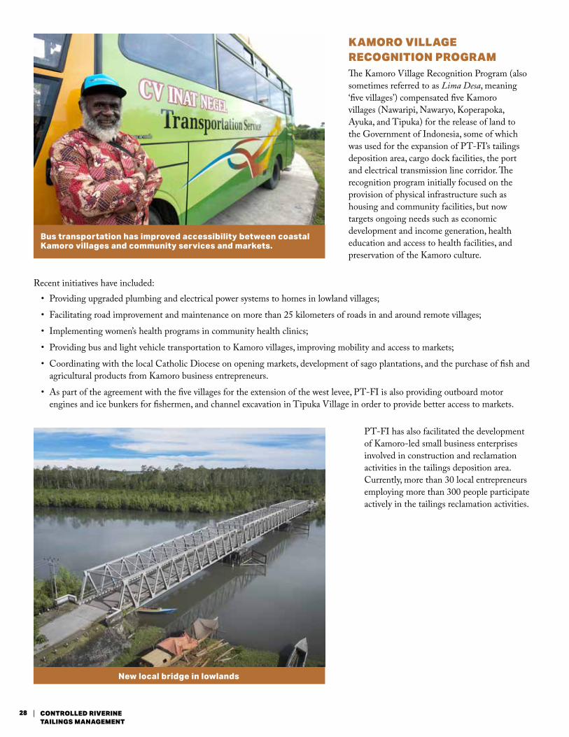
Bus transportation has improved accessibility between coastal Kamoro villages and community services and markets.
New local bridge in lowlands
KAMORO VILLAGE RECOGNITION PROGRAMThe Kamoro Village Recognition Program (also sometimes referred to as Lima Desa, meaning ‘five villages’) compensated five Kamoro villages (Nawaripi, Nawaryo, Koperapoka, Ayuka, and Tipuka) for the release of land to the Government of Indonesia, some of which was used for the expansion of PT-FI’s tailings deposition area, cargo dock facilities, the port and electrical transmission line corridor. The recognition program initially focused on the provision of physical infrastructure such as housing and community facilities, but now targets ongoing needs such as economic development and income generation, health education and access to health facilities, and preservation of the Kamoro culture.
PT-FI has also facilitated the development of Kamoro-led small business enterprises involved in construction and reclamation activities in the tailings deposition area. Currently, more than 30 local entrepreneurs employing more than 300 people participate actively in the tailings reclamation activities.
Recent initiatives have included: • Providing upgraded plumbing and electrical power systems to homes in lowland villages;
• Facilitating road improvement and maintenance on more than 25 kilometers of roads in and around remote villages;
• Implementing women’s health programs in community health clinics;
• Providing bus and light vehicle transportation to Kamoro villages, improving mobility and access to markets;
• Coordinating with the local Catholic Diocese on opening markets, development of sago plantations, and the purchase of fish and agricultural products from Kamoro business entrepreneurs.
• As part of the agreement with the five villages for the extension of the west levee, PT-FI is also providing outboard motor engines and ice bunkers for fishermen, and channel excavation in Tipuka Village in order to provide better access to markets.
28 CONTROLLED RIVERINE TAILINGS MANAGEMENT
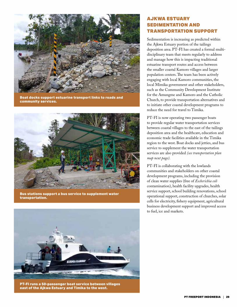
AJKWA ESTUARY SEDIMENTATION AND TRANSPORTATION SUPPORT
Sedimentation is increasing as predicted within the Ajkwa Estuary portion of the tailings deposition area. PT-FI has created a formal multi-disciplinary team that meets regularly to address and manage how this is impacting traditional estuarine transport routes and access between the smaller coastal Kamoro villages and larger population centers. The team has been actively engaging with local Kamoro communities, the local Mimika government and other stakeholders, such as the Community Development Institute for the Amungme and Kamoro and the Catholic Church, to provide transportation alternatives and to initiate other coastal development programs to reduce the need for travel to Timika.
PT-FI is now operating two passenger boats to provide regular water transportation services between coastal villages to the east of the tailings deposition area and the healthcare, education and economic trade facilities available in the Timika region to the west. Boat docks and jetties, and bus service to supplement the water transportation services are also provided (see transportation plan map next page).
PT-FI is collaborating with the lowlands communities and stakeholders on other coastal development programs, including the provision of clean water supplies (free of Escherichia coli contamination), health facility upgrades, health service support, school building renovations, school operational support, construction of churches, solar cells for electricity, fishery equipment, agricultural business development support and improved access to fuel, ice and markets.
Boat docks support estuarine transport links to roads and community services.
Bus stations support a bus service to supplement water transportation.
PT-FI runs a 50-passenger boat service between villages east of the Ajkwa Estuary and Timika to the west.
29PT FREEPORT INDONESIA
PT Freeport IndonesiaAffiliate of Freeport-McMoRan
Tipuka channel widening
Tipuka
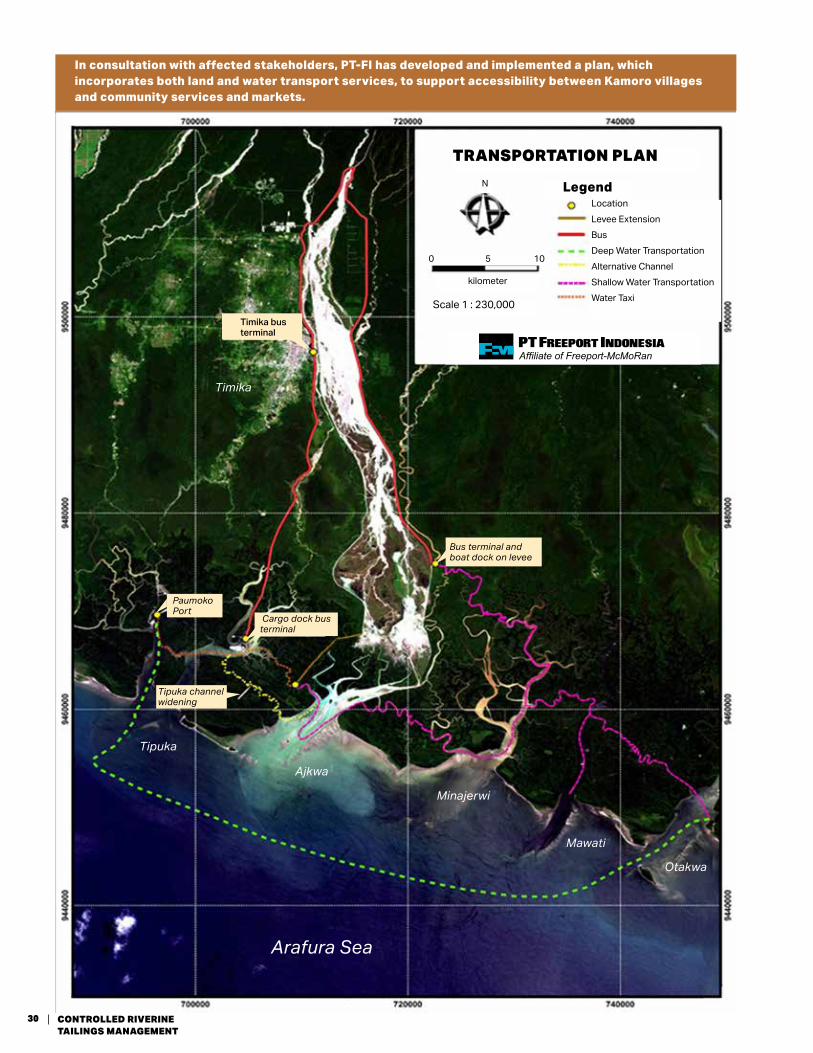
TRANSPORTATION PLAN
LegendLocationLevee ExtensionBus Deep Water TransportationAlternative ChannelShallow Water TransportationWater TaxiScale 1 : 230,000
kilometer
0 5 10
N
In consultation with affected stakeholders, PT-FI has developed and implemented a plan, which incorporates both land and water transport services, to support accessibility between Kamoro villages and community services and markets.
Arafura Sea
Timika
Bus terminal and boat dock on levee
Paumoko Port
Cargo dock bus terminal
Timika bus terminal
Ajkwa
Minajerwi
Mawati
Otakwa
30 CONTROLLED RIVERINE TAILINGS MANAGEMENT
Multipurpose community center in Timika
Childcare discussion in lowland clinic
LAND RIGHTS TRUST FUNDIn addition to the recognition compensation provided through development programs described above, PT-FI has established a Land Rights Trust Fund for the Amungme and Kamoro in further recognition of the expanded scope of the mining operation in both the highlands and lowlands. PT-FI has contributed nearly $54 million to this trust fund to date. The funds are administered by representatives of the two groups and PT-FI focusing on socio-economic resources, human rights, and environmental issues.
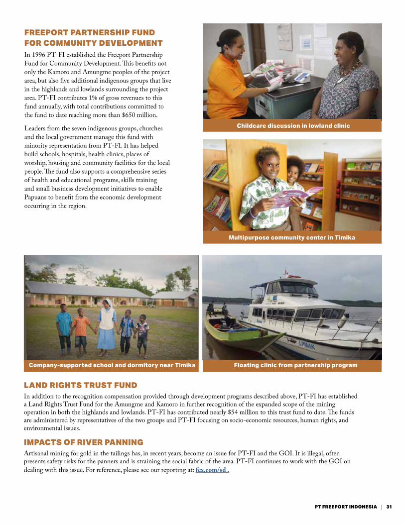
FREEPORT PARTNERSHIP FUND FOR COMMUNITY DEVELOPMENTIn 1996 PT-FI established the Freeport Partnership Fund for Community Development. This benefits not only the Kamoro and Amungme peoples of the project area, but also five additional indigenous groups that live in the highlands and lowlands surrounding the project area. PT-FI contributes 1% of gross revenues to this fund annually, with total contributions committed to the fund to date reaching more than $650 million.
Leaders from the seven indigenous groups, churches and the local government manage this fund with minority representation from PT-FI. It has helped build schools, hospitals, health clinics, places of worship, housing and community facilities for the local people. The fund also supports a comprehensive series of health and educational programs, skills training and small business development initiatives to enable Papuans to benefit from the economic development occurring in the region.
IMPACTS OF RIVER PANNING Artisanal mining for gold in the tailings has, in recent years, become an issue for PT-FI and the GOI. It is illegal, often presents safety risks for the panners and is straining the social fabric of the area. PT-FI continues to work with the GOI on dealing with this issue. For reference, please see our reporting at: fcx.com/sd .
Floating clinic from partnership programCompany-supported school and dormitory near Timika
31PT FREEPORT INDONESIA
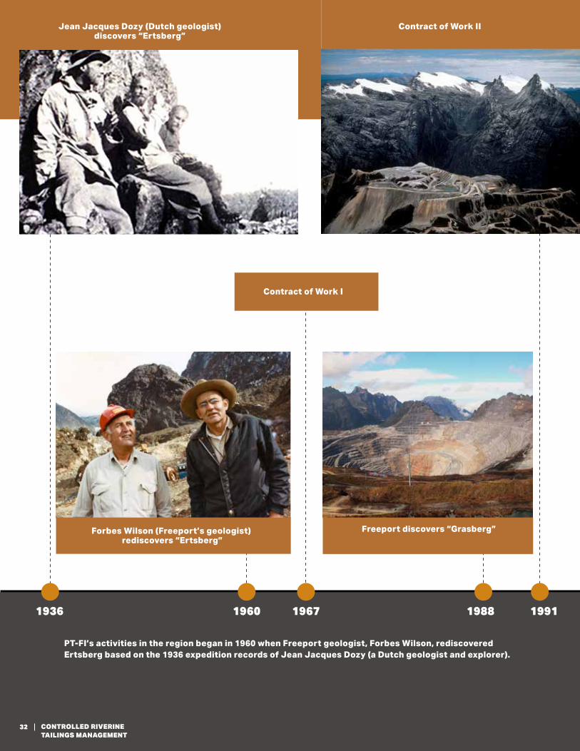
Forbes Wilson (Freeport’s geologist) rediscovers “Ertsberg”
Freeport discovers “Grasberg”
Contract of Work II
PT-FI’s activities in the region began in 1960 when Freeport geologist, Forbes Wilson, rediscovered Ertsberg based on the 1936 expedition records of Jean Jacques Dozy (a Dutch geologist and explorer).
1936 1960 1967 1988 1991
Contract of Work I
Jean Jacques Dozy (Dutch geologist) discovers “Ertsberg”
32 CONTROLLED RIVERINE TAILINGS MANAGEMENT
FREEPORT-MCMORAN'S
GLOBAL APPROACH
Grasberg, IndonesiaCerro Verde, Peru
El Abra, Chile
Morenci, ArizonaBagdad, ArizonaSierrita, ArizonaMiami, ArizonaSafford, Arizona
Tenke Fungurume, Democratic Republic of Congo
Worldwide Operations
Henderson, ColoradoClimax, Colorado
Chino, New Mexico Tyrone, New Mexico
Key:
Copper (Cu)
Cobalt (Co)
Molybdenum (Mo)
Gold (Au)
Locations
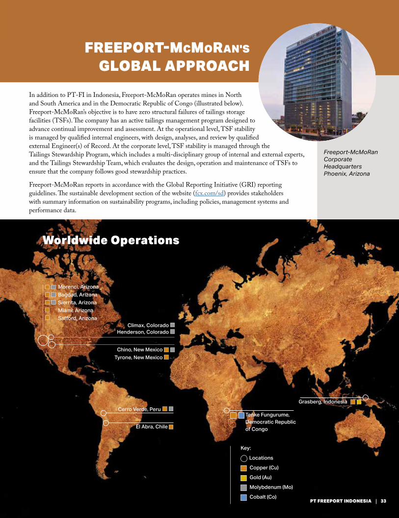
In addition to PT-FI in Indonesia, Freeport-McMoRan operates mines in North and South America and in the Democratic Republic of Congo (illustrated below). Freeport-McMoRan’s objective is to have zero structural failures of tailings storage facilities (TSFs). The company has an active tailings management program designed to advance continual improvement and assessment. At the operational level, TSF stability is managed by qualified internal engineers, with design, analyses, and review by qualified external Engineer(s) of Record. At the corporate level, TSF stability is managed through the Tailings Stewardship Program, which includes a multi-disciplinary group of internal and external experts, and the Tailings Stewardship Team, which evaluates the design, operation and maintenance of TSFs to ensure that the company follows good stewardship practices.
Freeport-McMoRan reports in accordance with the Global Reporting Initiative (GRI) reporting guidelines. The sustainable development section of the website (fcx.com/sd) provides stakeholders with summary information on sustainability programs, including policies, management systems and performance data.
Freeport-McMoRan Corporate HeadquartersPhoenix, Arizona
33PT FREEPORT INDONESIA
333 North Central Ave Phoenix, AZ fcx.com


![FREEPORT LNG TERMINAL · 2020. 5. 20. · FREEPORT LNG TERMINAL FREEPORT MARINE OPERATIONS MANUAL [04/15/20]2 FREEPORT LNG CONTACT INFORMATION TERMINAL OFFICES Freeport LNG Terminal](https://static.documents.pub/doc/80x56/606c9d1603f05e3bdb64da66/freeport-lng-terminal-2020-5-20-freeport-lng-terminal-freeport-marine-operations.jpg)
