94
Controlling The Floods The Role of the U.S. Army Corps of Engineers In the History of the Middle Rio Grande Conservancy District

Controlling The FloodsThe Role of the U.S. Army Corps of EngineersIn the History of the Middle Rio Grande Conservancy District


�Controlling the Floods
FINAL
CONTROLLING THE FLOODS:The Role of the U.S. Army Corps of Engineers
In the History of the Middle Rio Grande Conservancy District
Prepared byW�ll�am A. dodge, Ph.d.
and Abraham sant�llanes
Karen Van C�ttersPr�nc�pal invest�gator
Van C�tters: h�stor�c Preservat�on, llCAlbuquerque, new Mex�co
Prepared forAlbuquerque d�str�ct Corps of eng�neers
Contract no. W912PP-06-F-0053
november 2007

�� eXeCUtiVe sUMMArY
EXECUTIVE SUMMARY
Van C�tters: h�stor�c Preservat�on, llC (VChP) was contracted by the Un�ted states Army Corps of eng�neers (UsACe; contract no. W912PP-6-F0053) to �nventory and assess the h�stor�c s�gn�ficance of structures and features constructed by the M�ddle r�o grande Conservancy d�str�ct (MrgCd) and later renovated by the Corps and the Bureau of reclamat�on between the commun�t�es of Bernal�llo and Belen w�th a spec�al emphas�s on that stretch of the r�ver found w�th�n the Albuquerque d�str�ct.
Upon �ts creat�on �n 1928, the MrgCd began des�gn�ng and bu�ld�ng a comprehens�ve system of dams, canals, laterals, and dra�ns to d�vert water from the r�o grande for agr�cultural use and dra�n away excess water from the fields to recla�m pr�me farm land. the vagar�es of the r�o grande’s flow character�st�cs also necess�tated the construct�on of levees and jett�es to channel�ze the r�ver and help control per�od�c flood�ng that had plagued the res�dents of the m�ddle r�o grande valley s�nce pre-Columb�an t�mes.
VChP categor�zed the types of structures and features found w�th�n the MrgCd and determ�ned that wh�le no �nd�v�dual structures were el�g�ble for the nat�onal reg�ster of h�stor�c Places due to a lack of h�stor�c �ntegr�ty caused by renovat�ons carr�ed out �n the 1950-60s, the system as a whole was el�g�ble as a h�stor�c d�str�ct under Cr�ter�on A, �.e., for �ts contr�but�ons to h�story of agr�culture and urban development along the r�o grande located w�th�n the study area. should the MrgCd be determ�ned el�g�ble for the nat�onal reg�ster, VChP recommends that the UsACe explore the poss�b�l�ty of develop�ng a mult�-agency programmat�c agreement to ass�st w�th the management of effects that m�ght occur to the d�str�ct �n the future.

���Controlling the Floods
LIST OF ACRONYMS & ABBREVIATIONS
MrgCd M�ddle r�o grande Conservancy d�str�ctnhPA nat�onal h�stor�c Preservat�on Act nat�onal reg�ster nat�onal reg�ster of h�stor�c PlacesPA Programmat�c Agreement PWA Publ�c Works Adm�n�strat�on WPA Works Progress Adm�n�strat�onrFC reconstruct�on F�nance Corporat�on UsACe Un�ted states Army Corps of eng�neers UsBr Un�ted states Bureau of reclamat�onUsdA Un�ted states department of Agr�cultureVChP Van C�tters: h�stor�c Preservat�on, llC

�v tABle oF Contents
TABLE OF CONTENTS
eXeCUtiVe sUMMArY .....................................................................................................................��list oF ACronYMs & ABBreViAtions .......................................................................................... ���tABle oF Contents ..................................................................................................................... �vlist oF FigUres ............................................................................................................................ v�list oF tABles .............................................................................................................................. v��
i. introdUCtion .......................................................................................................................... 1 Project descr�pt�on ..................................................................................................................... 1 Prev�ous stud�es ........................................................................................................................ 2 F�eldwork ................................................................................................................................. 3
ii. the Middle rio grAnde And A BrieF historY oF WAter Control in CentrAl neWMeXiCo ........................................................................................................................................ 5 the r�ver .................................................................................................................................. 5 A h�stor�cal summary of Water Control on the M�ddle r�o grande ............................................... 11
iii. the Middle rio grAnde ConserVAnCY distriCt ................................................................. 19 establ�shment of the d�str�ct ....................................................................................................... 19 Construct�on of the MrgCd Plan ............................................................................................... 24 Flood Control structures ........................................................................................................... 24 irr�gat�on system ............................................................................................................... 28 MrgCd’s F�rst decade: success and Fa�lure ............................................................................... 35 the impact of the Federal Flood Control Acts on the MrgCd ...................................................... 35 the MrgCd: Post-War Federal Ass�stance ................................................................................. 38 the effects of Urban�zat�on on MrgCd Plann�ng ....................................................................... 45 summary: the h�stor�cal s�gn�ficance of the MrgCd Project ........................................................ 48
iV. tYPes oF engineering strUCtUres Within the stUdY AreA oF the Middle rio grAnde ConserVAnCY distriCt ............................................................................................................ 53 Flood Control and Channel rect�ficat�on structures ...................................................................... 53 levees .............................................................................................................................. 53 Permeable Jett�es ............................................................................................................... 56 irr�gat�on system Features ......................................................................................................... 60 d�vers�on dams ................................................................................................................. 60 Canals ............................................................................................................................. 61 laterals ............................................................................................................................ 64 Acequias .......................................................................................................................... 65 Canal and lateral Features ................................................................................................. 66

vControlling the Floods
dra�ns .............................................................................................................................. 68
V. eVAlUAtion oF nAtionAl register signiFiCAnCe For MrgCd engineering strUCtUres And FeAtUres .......................................................................................................................... 71
Vi. MAnAgeMent reCoMMendAtions For the leVees And JettY JACKs As ContriBUting eleMents to the historiC distriCt .......................................................................................... 75
reFerenCes Cited ...................................................................................................................... 77

v� list oF FigUres
LIST OF FIGURES
F�gure 1. Aer�al v�ew of the r�o grande w�nd�ng through Albuquerque’s south Valley, 1935 .................................... 5
F�gure 2. r�o grande valley show�ng mounta�n ranges, major tr�butar�es, and 17th century span�sh prov�nces. .......... 6
F�gure 3. Flood�ng �n Albuquerque’s north Valley, 1929; Barelas Br�dge destroyed by flood�ng, 1912 ...................... 7
F�gure 4. old town Br�dge across the r�o grande �n Albuquerque, c�rca 1880s .................................................... 10
F�gure 5. Acequ�a system, c�rca 1890s ............................................................................................................. 14
F�gure 6. h�stor�c span�sh v�llages around present-day Albuquerque .................................................................... 14
F�gure 7. terr�tor�al Fa�r exh�b�t by old town farmer, herman Blueher, c�rca 1890s. Poster �n upper r�ght hand corner
reads: “new Mex�co by irr�gat�on can eas�ly support a m�ll�on people.” ............................................... 16
F�gure 8. d�v�s�ons of the MrgCd .................................................................................................................... 21
F�gure 9. headl�ne and advert�sements promot�ng the MrgCd ............................................................................ 22
F�gure 10. Map of MrgCd- Albuquerque d�v�s�on, 1935 ........................................................................... Fold out
F�gure 11. el Vado dam and reservo�r .............................................................................................................. 24
F�gure 12. Aer�al v�ew of the r�o grande, MrgCd levee, and r�vers�de dra�n, May, 1952..................................... 27
F�gure 13. draw�ng of spo�l-bank levee and r�vers�de dra�n, c�rca 1930s.............................................................. 27
F�gure 14. draw�ng of levee protect�on, 1939; Brush protect�on structure w�th w�re mesh fence on MrgCd
levee, 1931 .................................................................................................................................. 28
F�gure 15. schemat�c of the MrgCd �rr�gat�on system ........................................................................................ 29
F�gure 16. Angostura d�vers�on dam, look�ng west, 2007 ................................................................................... 29
F�gure 17. MrgCd �rr�gat�on d�tch under construct�on near laguna cut-off h�ghway, 1931 ..................................... 30
F�gure 18. isleta d�vers�on dam, 1945 .............................................................................................................. 31
F�gure 19. Brush and w�re re�nforcement structures on bank of the Albuquerque r�vers�de dra�n, 1930; Cerro inter�or
dra�n, 1955 .................................................................................................................................. 34
F�gure 20. ex�st�ng and proposed dams, reservo�rs, and other M�ddle r�o grande projects, mod�fied from a 1950 map
to show the Coch�t� and gal�steo dams ............................................................................................. 36
F�gure 21. Map and �llustrat�ons of m�ddle r�o grande valley show�ng nat�onal defense �nstallat�ons, transportat�on
routes, �mportant �nfrastructure features, and commun�t�es potent�ally threatened by r�o grande flood�ng .. 41
F�gure 22. Aer�al v�ew of Coch�t� dam soon after complet�on, look�ng southeast .................................................... 42
F�gure 23. draw�ng of typ�cal flood protect�on and channel �mprovement work, 1927 ........................................... 42
F�gure 24. MrgCd jetty jack field �n r�o grande near Bosque, new Mex�co, 1956 .............................................. 42
F�gure 25. Jett�es us�ng brush structures and Kellner jacks (type C) near outlet of the Albuquerque r�vers�de dra�n adjacent
to old town, 1931 ........................................................................................................................ 42
F�gure 26. rehab�l�tat�on of the isleta d�vers�on dam, 1955 ................................................................................. 44
F�gure 27. Aer�al v�ew of downtown Albuquerque and north Valley, 1935 ........................................................... 49
F�gure 28. Aer�al v�ew of north Valley, 1963 .................................................................................................... 50
F�gure 29. north Valley acequ�a off the gallegos lateral, 2007. gallegos lateral west of r�o grande Blvd.�n the north
Valley, 2007.................................................................................................................................. 51
F�gure 30. spec�al�zed equ�pment (“d�tcher w�th spo�l w�ngs”) des�gned for renovat�ng MrgCd structures at los Chavez
Acequ�a, 1956 .............................................................................................................................. 52
F�gure 31. draw�ng of typ�cal sect�on of r�vers�de dra�n and levee, 1939 ............................................................. 53

v��Controlling the Floods
F�gure 32. draw�ng of typ�cal levee renovat�on, show�ng use of perv�ous mater�als and toe dra�n des�gn,ca.1980s ... 54
F�gure 33. “eng�neered” levee just north of Central Ave. Br�dge, Albuquerque, 2007 ............................................ 54
F�gure 34. draw�ng of MrgCd levee protect�on featur�ng p�l�ngs w�th tr�angle mesh w�re fenc�ng �n the Country Club area
of Albuquerque, 1928 .................................................................................................................... 55
F�gure 35. P�l�ngs and w�re fenc�ng protect�ng levee bank near old town, 1931 ................................................... 55
F�gure 36. draw�ng of typ�cal plan for r�ver protect�on work, 1928 ...................................................................... 56
F�gure 37. draw�ng of type A permeable jetty featur�ng p�l�ngs and brush structures, 1928 .................................... 56
F�gure 38. draw�ng of typ�cal r�ver jetty made of brush and cable, 1939 ............................................................. 56
F�gure 39. draw�ng of type B permeable jetty featur�ng w�re fenc�ng, 1928 .......................................................... 57
F�gure 40. draw�ng of a non-typ�cal Kellner steel jack des�gn, referred to as the MrgCd type C, 1928 ................... 57
F�gure 41. draw�ng of typ�cal jetty field, c�rca 1980s ......................................................................................... 58
F�gure 42. draw�ng of standard Kellner jack des�gn used post-WW ii .................................................................. 58
F�gure 43. Assembl�ng Kellner jacks, c�rca 1950s. source: UsBr. ........................................................................ 59
F�gure 44. Plac�ng Kellner jacks �n r�o grande floodpla�n, Belen d�v�s�on, 1956 .................................................. 59
F�gure 45. Kellner jack field north of Central Ave. Br�dge, Albuquerque, 2007. the r�o grande �s located beh�nd the l�ne
of trees on the r�ght of the photo – some d�stance from the jetty jack field .............................................. 59
F�gure 46. outlet works at the Angostura d�vers�on dam, 2007 ........................................................................... 60
F�gure 47. Proposed plan of the r�ver d�vers�on at Angostura dam, 1928. source: MrgCd. ................................... 61
F�gure 48. Concrete l�ned Albuquerque Ma�n Canal, 2007 ................................................................................ 61
F�gure 49. draw�ng of proposed r�ver d�vers�on at Corrales (Albuquerque d�vers�on), 1928 ................................... 62
F�gure 50. Construct�on draw�ngs of a monol�th�c concrete s�phon and an alternat�ve wooden s�phon proposed for the
Corrales un�t, 1933 ........................................................................................................................ 62
F�gure 51. rehab�l�tat�on of the Atr�sco s�phon, 1956 ........................................................................................ 63
F�gure 52. rehab�l�tat�on of Albuquerque r�vers�de dra�n show�ng �nstallat�on of 72-�nch concrete p�pe, 1955 ......... 63
F�gure 53. renovat�on of the Alameda inter�or dra�n, 1955 ................................................................................ 63
F�gure 54. Construct�on of a new concrete drop structure for Belen wasteway, 1957 .............................................. 63
F�gure 55. Clean�ng operat�ons on the lower old Jarales Acequ�a, 1957 ............................................................ 63
F�gure 56. hun�ng lateral �n the Belen Area show�ng new concrete check structure, 1957 ...................................... 64
F�gure 57. Acequ�a turnouts located along the gallegos lateral �n the north Valley, 2007 ...................................... 64
F�gure 58. draw�ng of typ�cal sect�ons for �rr�gat�on d�tch renovat�ons, 1939 ........................................................ 65
F�gure 59. old style acequ�a near Algodones, 2007 ......................................................................................... 65
F�gure 60. Construct�on draw�ng of flash-board ho�sts for turnout, date unknown ................................................... 66
F�gure 61. Metal turnout on old Jarales acequ�a, 1957 ..................................................................................... 66
F�gure 62. Metal turnout and precast concrete headwall �nstalled on old Jarales Acequ�a, 1957 ............................ 67
F�gure 63. rad�al gate check on un�dent�fied lateral �n the socorro d�v�s�on, 1952. ............................................... 67
F�gure 64. draw�ng of standard p�pe flumes w�th t�mber substructure, 1930 .......................................................... 68
F�gure 65. gallegos �rr�gat�on flume cross�ng the Alameda inter�or dra�n, 1930; Covered flume carry�ng �rr�gat�on water
over the Alameda inter�or dra�n near old town, 1930 ....................................................................... 68
F�gure 66. Albuquerque r�vers�de dra�n look�ng south near old town, 1931. ....................................................... 69
F�gure 67. Albuquerque r�vers�de dra�n at the gr�egos head�ng, 1952. .............................................................. 69
F�gure 68. Alameda inter�or dra�n, look�ng north along second st., 2007 ............................................................ 70

v��� list oF tABles
LIST OF TABLES
table 1. MrgCd ma�n canals, 1940 .............................................................................................. 30table 2. MrgCd �rr�gat�on system, post-UsBr renovat�ons (c�rca early 1960s). ................................... 45table 3. Populat�on of Albuquerque and geograph�cal s�ze by decade ................................................ 46table 4. Populat�on figures from the 1880 census of the h�span�c commun�t�es border�ng new town Albuquerque at �ts found�ng. ............................................................................................. 48

�Controlling the Floods
I. INTRODUCTION
PROJECT DESCRIPTION
since the early �940s, the U.s. Army Corps of engineers, Albuquerque district (UsACe), has assisted the Middle rio grande Conservancy district (MrgCd) to prevent flood damage to the district’s irrigation system, as well as private and commercial property along the middle rio grande valley. this system, consisting of canals, ditches, drains, and levees, was built in the early �930s to reclaim agricultural land in the middle val-ley, improve farm land production, and control historically damaging floods. From the �950s to the present day, the UsACe, together with the U.s. Bureau of reclamation (UsBr) and MrgCd, has developed projects to update and improve the system by rehabilitating aging irrigation structures and building new structures to alleviate problems of high water tables, channel aggradation, and flooding. the UsACe continues to develop projects in cooperation with the MrgCd, and since much of its work could have an effect on features of this water control and irrigation system which may eligible for inclusion in the national register of historic Places, the UsACe contracted with Van Citters: historic Preservation (VChP) to undertake the following tasks:
�. identify levees, acequias, drains, and other water control structures found along the middle rio grande valley within the Middle rio grande Conservancy district (MrgCd) and evaluate their sig-nificance;
2. Prepare a historic context in which to evaluate the significance of these structures; and 3. Assess the eligibility of these structures for inclusion in the national register of historic Places.
in its statement of work, the UsACe defined the project area as the land on the river side of the MrgCd levees, the levees themselves, and the land between the landward side of the levees and the boundary to private property from both banks of the rio grande between the communities of Bernalillo and Belen. the UsACe further directed VChP to give special emphasis to the structures found between the north diversion Channel and the south diversion Channel in Albuquerque. By mutual agreement, this study focuses on the period between the initial construction of the MrgCd, beginning in �930, and ends with the opening of Cochiti dam in �975. this end date was chosen because the closing of the dam, some 50 miles north of Albuquerque, was the last major flood control structure to be built on the rio grande and was designed to significantly diminish the threat of large-scale flooding in the middle valley. its completion signaled a signifi-cant change in water control management strategies for the middle rio grande. the types of irrigation and flood control structures found within the project area include levees, drains, canals, acequias, lateral ditches, feeder ditches, wasteways, siphons, flumes, headgates, and jetty jacks that were, for the most part, built to standardized specifications and which have been repaired, modified, and upgraded

2 ChAPter iintrodUCtion
many times since their original installation in the �930s. Understanding that very few of the existing structures are unmodified, the UsACe and VChP agreed that rather than identifying specific structures (unless they were original or unique in materials and design), VChP would identify and describe the general types of MrgCd structures commonly found within the project area. to properly evaluate the historic significance of MrgCd’s engineering structures and features, VChP devel-oped a historic context for water control along the middle rio grande valley that includes a summary of pre-Columbian, spanish, and territorial water management strategies, followed by a more in-depth look at the creation of the MrgCd and the original design of the system. this section was prepared through an extensive literature search of primary documents and secondary sources from the following archives:
• the Center for southwest research, University of new Mexico,• Zimmerman, Centennial, and Parish libraries, University of new Mexico,• the Middle rio grande Conservancy district offices, Albuquerque,• the Bureau of reclamation, Albuquerque, and• the Corps of engineers, Albuquerque.
the following report includes:(�) a summary of the rio grande’s general characteristics and how they have played a significant role
in the history of water control in the middle rio grande valley;(2) a summary discussion of the types of flood control, irrigation, and drainage structures constructed in
the valley prior to the establishment of the MrgCd;(3) a more detailed account of the creation of the MrgCd, its irrigation and flood control structures, and
how the UsACe and the UsBr provided assistance to the MrgCd following the second World War, and the effects of urbanization on the original purpose of the district’s Albuquerque Unit;
(4) a description of the types of engineering structures and features found in the MrgCd;(5) an evaluation of the historic significance of the conservancy district and its engineering structures with
recommendations of eligibility for the national register of historic Places; and(6) management recommendations regarding the treatment of historic properties within the MrgCd
system.
PREvIOuS STuDIES
this project has benefited from the research previously conducted in the rio grande valley on irrigation development and the history of the river and actions taken to manage its water flows. Arguably, the most comprehensive study of water resources in new Mexico is ira Clark’s Water in New Mexico (�987). Clark details the use of water in the state from pre-Columbian times to the late twentieth century, including the effects of international treaties and interstate agreements on state policies and the ever-increasing role of the federal government in managing the state’s water resources.

3Controlling the Floods
in �998, dan scurlock prepared a thorough study of the environmental history of the rio grande which offers a detailed look at systemic changes that have affected the river in historic times, particularly in the late nine-teenth and first half of the twentieth centuries. his work provided an excellent overview of the rio grande’s characteristics.
A report entitled, The Development of Irrigation Systems in the Middle Rio Grande Conservancy District Cen-tral New Mexico: A Historical Overview (�997), prepared by neal W. Ackerly, david A. Phillips, Jr., and Kevin (lex) Palmer for the Bureau of reclamation, was an extremely valuable document for this study. the au-thors examined the MrgCd’s role in the revitalization of the middle valley’s agricultural economy by focusing on the contributions made by the UsBr to the rehabilitation of the MrgCd’s irrigation and drainage system. the present study dovetails very nicely with the research presented in the Ackerly report, and provides a more complete picture of post-World War ii federal assistance provided to the conservancy district.
Frank Wozniak’s Irrigation in the Rio Grande Valley (�998) is an updated version of his �987 study for the UsBr in which he presents an in-depth look at irrigation works from spanish Colonial times through the �960s. this study was an invaluable resource for understanding the types of irrigation practices utilized prior to the development of the MrgCd.
other studies of particular interest to this project included Michael Welsh’s history of the UsACe published in �987, especially the chapter on the middle rio grande valley. in 2002, Kathy grassel completed a short study on jetty jack removal within the middle valley. her work provided a good introduction into the history of these engineering structures and the issues concerning their removal and river restoration. Finally, this present study is a continuation of a history of the UsACe’s contributions to flood protection along the rio grande first set forth in a report prepared by K. lynn Berry and Karen lewis in �997. their historical documentation of engineering structures covered that portion of the river immediately north (Corrales) and south (from Belen to san Marcial) of our study area.
FIELDWORK
the fieldwork for this project was limited to spot checks of major MrgCd features, such as levees, canals, and drains to observe firsthand the design of this system, and examine the modifications made to these struc-tures during the past 75 years.

4 ChAPter iintrodUCtion

�Controlling the Floods
II. THE MIDDLE RIO GRANDE AND A BRIEF HISTORY OFWATER CONTROL IN CENTRAL NEW MEXICO
The RiveR
Formed some five million years ago, the rio grande is an ancient waterway that for centuries has provided a lifeline to people living along its banks (Figure 1). the river, most frequently called the “rio del norte” during the spanish Colonial period, has historically been an unpredictable natural asset. While its yearly flooding cycles, generally one in the spring and one in the late summer, have provided the water that is so necessary
Figure 1. Aerial view of the Rio Grande winding through Albuquerque’s South Valley, 1935. Tijeras Arroyo can be seen draining into the valley in the lower right corner. Source: MRGCD.

� ChAPter iithe middle rio grAnde
in this high desert region for the growing of crops and the rejuvenation of the riparian vegetation that grows along its banks, the vagaries of these floods and the river’s unpredictable tendency to shift channels and change its course have resulted in the loss of life and property to those living adjacent to it. it has been this benefit, as well as this risk, that has caused communities and governments to invest time, money, and resources to controlling and managing this valuable asset in order to maximize its life-giving benefits while
minimizing its destructive forces.
the headwaters of the river are found in the mountains of southern Colorado. From here, the waterway follows a southerly course through new mexico to el Paso for almost �00 miles, until it bends gently to the southeast and makes its way to the gulf of mexico, some 1,88� miles from its starting point (scurlock 1998, 184). geographers and other researchers have divided the rio grande valley in new mexico into three sections: the upper, middle, and lower valleys. this study is located within the middle rio grande
valley, a section of the river located between the mouth of White rock Canyon just above Cochiti Pueblo and the point
where the rio salado joins the rio grande, just north of san Acacia – a total distance of approximately 1�0 miles. more specifically, the study area includes what is known as the Albuquerque reach of the middle rio grande valley, namely, that stretch of the river between the communities of Alameda and Belen.
the middle rio grande valley is situated within the rio grande rift, a geological feature that has resulted in
the formation of the sandia mountains. the sandias are the southern-most extension of the rocky mountains whose block-faulted western slope forms a dramatic topographic backdrop to the valley’s east side. on the west side of the valley, the low-rising Jemez mountains have been formed from volcanic uplifting, a highly geologically active zone also represented by the widely dispersed volcanic cinder cones found on the bluffs above the river just west of Albuquerque in an area referred to as the llano de Albuquerque. rolling, gravel terraces, remnants of ancient stream channels immediately flank either side of the river (scurlock 1998, 181).
several major drainages, as well as numerous smaller arroyos, feed into the rio grande along its course through the middle valley (Figure 2). to the north of
Figure 2. Rio Grande valley showing mountain ranges, major tributaries, and 17th century Spanish provinces. Source: Scurlock (1998, Figure 5).

�Controlling the Floods
Albuquerque the major tributaries include the santa Fe river, las huertas Creek, and the Jemez river, while the rio Puerco and rio salado enter the river south of the city. this drainage area encompasses 24,��0
square miles (scurlock 1998, 181).
the inner valley, or floodplain, of this stretch of the rio grande varies from one-half mile to five miles wide (Bartolino and Cole 2002, 9). it is marked by variable flows corresponding with runoff from spring snow melts in the northern mountains, which can produce extensive flooding from April until June, and late summer thunderstorms occurring from July through september, which produce sudden, but short-lived flooding episodes. scurlock (1988, 32) has documented eighty-two “moderate” to “major” floods (defined as river flows exceeding 10,000 cfs) between 1�91 and 1942 including an 1828 flood that is estimated to have exceeded 100,000 cfs. According to the Santa Fe New Mexican, a spring flood in 18�� caused the evacuation of several small towns, including sabinal, Padillas, Pajarito, and Atrisco (Carter 19�3, �, see also Yeo n.d., 13-14). the historian marc simmons (1982, 19�) reports that the 18�� spring flood wiped out most of the wheat and corn fields in Bernalillo County, causing local residents to flee to the sand hills flanking the river and, later in the year, to request foodstuffs from the local Pueblos to make it through the winter. records of river flooding became more reliable beginning in the 18�0s, and between 1849 and 1942, scurlock (1998, table 1�) notes that moderate or major flooding occurred every 1.9 years, including five years (1884, 188�, 189�, 190�, and 1911) in which there were two flood episodes each exceeding 10,000 cfs (Figure 3). this included floods in 18�2 and 1884 that exceeded 100,000 cfs. the 18�2 flood caused extensive damage, putting many communities between Alameda and Barelas under water, and left Albuquerque (present day old town) an island in the river (Yeo n.d., 1�-1�). two years later, a flood estimated at 40,000 cfs caused Albuquerque residents to hastily build dikes to hold back the floodwaters (Carter 19�3, 9). the river channel
shifted again some 1.� miles to the east.
Figure 3. Flooding in Albuquerque’s North Valley, 1929; Barelas Bridge destroyed by Rio Grande flooding, 1912. Source: Biebel (1986, 62); Center for Southwest Research, Cobb Memorial Collection, University of New Mexico.

8 ChAPter iithe middle rio grAnde
Perhaps the most devastating flood on the rio grande began on 21 may 1884 and lasted nine days (nanninga 1982, 99; scurlock 1998, table 1�, 38).1 Although there were no gauging stations along the river, reliable estimates put the peak flow at 100,000 cfs. the flood damaged personal property, agricultural fields and acequias from Albuquerque to el Paso and took the lives of several residents of villages in its path. the severity of the flood obliterated all existing channels and created a new one. in 1904, two flood episodes were recorded in the study area. the second flood, estimated at 33,000 cfs, occurred in late september and resulted in the inundation of Corrales, Bernalillo, Barelas, and Atrisco (Yeo n.d., 33-34). the damage caused by these severe floods increased as the population along the river grew. the 1904 flood was described by The Albuquerque Journal on the morning of 1 october as follows:
The swollen Rio Grande has found its way around both ends of the Alameda Dike . . . Alameda, Los Corrales, and Barelas are as usual the heaviest sufferers. In Barelas yesterday the water stood 2 feet deep in many of the houses and people moved out all their belongings that could be taken at short notice. . . Looking down from the mesa, it looked as if the entire valley from foothill to foothill, was under water. Just west of the city the Rio Grande was fully four miles wide and yesterday the water found its way up to the grandstand in the fairgrounds . . .2
A year later, these areas were hit again with one observer noting that Bernalillo looked like an “inland sea” (Yeo n.d., 38-39). in 1912, the bridge at Barelas was destroyed. A major flood in 1920 (estimated at 18,000 to 24,000 cfs) overflowed the river’s banks at los griegos and los Candelarias and caused considerable damage. isleta Pueblo was also particularly hard hit, losing over �,000 acres of agricultural land (ibid., �2-��).
much of this late nineteenth and early twentieth century flooding was caused by land use practices that intensified the clearing of upland forests, increased livestock grazing, and utilized intensive agricultural practices all of which increased stream runoff and sedimentation. Although the flood benefits included the deposition of nutrient-rich sediments, adequate irrigation water, and flushed salts from the fields, as the population in the middle rio grande valley increased and villages, towns, and cities grew in land size, these floods became an increasing threat to life and property. in response to the damaging floods of the early twentieth century, the UsACe and UsBr constructed a series of dams upstream from the growing city of Albuquerque, including el Vado (193�), Jemez Canyon (19�3), Abiquiu (19�3), galisteo (19�0), and Cochiti (19��) (scurlock 1998, 38; see also new mexico state engineer office 19��, 13�).
Another significant characteristic of the rio grande is its tendency to shift channels through the process of avulsion – the shifting of a river channel from a higher to lower elevation. Avulsion on the rio grande was exacerbated by the steady aggradation of the river prior to the construction of the aforementioned dams
1 robert nanninga (1982) reports the year as 18�4 rather than 1884, but based on scurlock’s data, this must be a typographical error since although there was a major flood in 18�4 measuring 40,000 cfs, the great flood of 1884 was of such a magnitude as to receive the attention of numerous researchers and even the U.s. Court of Private Claims. 2 the territorial Fairgrounds in 1904 were located just to the west of present-day Central Avenue and rio grande Boulevard.

9Controlling the Floods
(lagasse 1980, 8-9). Aggrading of the river bed is a natural tendency bolstered by the river’s steep slope, especially in the reaches north of Albuquerque, and the heavy sediment load coming not only from the main stem of the rio grande, but its major tributaries as well.3 Prior to the dams, the natural low sinuosity of the rio grande resulted in the formation of sediment bars, often with heavy vegetation, that caused channel reconfiguration. At the same time, the lack of rigid soil structure in the river bed made it prone to severe scouring, sometimes to a depth of ten to twenty feet. this scouring was not uniform throughout the width of the bed, however, in that the heaviest scouring would take place in the narrow section of the river and the resulting sediments would then be deposited in the wider sections naturally causing aggradation, bank erosion, and channel shifts.
A general westward shift of the rio grande occurred in the first half of the eighteenth century between san Felipe Pueblo and the colonial village of Belen, south of Albuquerque (scurlock 1998, fig. ��). this channel shift destroyed homes and the church in the town of Bernalillo sometime before 1�09. the river shifted from west to east again in 1��3 when spanish accounts stated that residents of “upper” Bernalillo had to move to the village of Algodones. the village of Alameda was also affected by this event. the original spanish villa of Albuquerque was frequently left isolated amidst floodwaters as the rio grande regularly shifted channels to the east between present-day Fourth and second streets (scurlock 1998, 18�).
the frequent flooding and shifts in the river channel, together with the increase in irrigation agriculture through time, resulted in the creation of thick stands of riparian woodlands, or bosques, as well as areas of low-lying marshes (cienegas), ponds (charcos), and swamps (esteros) (scurlock 1998, 18�). one particularly wet area, known as the Esteros de Mejia, was located just south of Albuquerque’s new town (present-day downtown) in the Barelas neighborhood (simmons 1982, 40). Prior to deforestation for building materials and firewood by hispanic and American settlers, the bosque along the Albuquerque reach was extensive and lush. thick stands of cottonwoods (Populus deltoids) and willow (Salix sp.), with an understory of salt grass (Distichlis spicata), populated the floodplain (scurlock 1988; 1998, 201). A particularly dense stand located along the east side of the river between Alameda and old town Albuquerque was referred to as the Bosque Grande de San Francisco Xavier by early inhabitants of the villa (Adams and Chavez 19��, 14�). in other areas, open, grassy lowlands (vegas) dominated the landscape. the rio grande’s bosques were enhanced by the river’s natural flood cycle, referred to in the biological community as the flood-pulse concept (molles et al. 1998, �49). this cycle of a spring pulse that peaked in late may, sometimes lasting until late July, created braided river channels, marshes, and wet meadows, which maintained the diverse riverine ecosystem. the construction of dams, levees, and drains has subsequently altered this flood-pulse process and thus severely curtailed the rejuvenation of existing bosques and stunted the formation of new ones.
As one might expect, the deposition of sediments during annual floods was a boon to local farmers. marc simmons reports that one early new mexican commented in 1��3 that, “the water brings with it a thick mud which serves as manure for the land, leaving on top of the irrigated earth a glutinous scum resembling
3 it is estimated that in the late 19�0s, as much as three tons of sediment per year passed through the otowi Bridge gauging station on the rio grande. Just downstream, an average of 1,800 acre-feet was deposited in the Cochiti dam reservoir. the Jemez, galisteo, and Cochiti dams thus controlled 80% of sediment inflow into the rio grande above Albuquerque (lagasse 1980, 12-13).

10 ChAPter iithe middle rio grAnde
lard” (1982, 9�). however, by the late nineteenth century sedimentation was becoming a serious problem in the middle rio grande valley. overgrazing, heavy logging activity and more intensive agricultural practices in southern Colorado and northern new mexico dramatically increased the river’s sediment load resulting in the rio grande becoming an aggrading riverbed (Wozniak 1998). Until checked by the construction of upstream dams, it was estimated that the river carried �� billion pounds of sediments annually downstream (simmons 1991, �9, ��). in the 18�0s, the river had begun to noticeably slow down and spread out across its floodplain. travelers report that at the Barelas crossing and at isleta Pueblo the rio grande was 200 to 300 yards wide and three to four feet deep (Beadle 19�3, 491; Cozzens 1988, 2�4-��). By 18�9, the river between Albuquerque and el Paso ceased to run altogether for much of the year (scurlock 1998, 188). sediments in the river started to pile up and form islands, two of which were observed just opposite of sandia Pueblo supporting a stand of cottonwoods and estimated to be �00 acres in size (Poore 1894, 111).
the rio grande offered a different “look” depending on the time of year and whether there had been heavy snows the previous winter. in the mid-1800s, Josiah gregg described the river as follows:
The Rio del Norte . . . decreases in volume of the water as it descends. In fact, above the region of tide-water, it is almost everywhere fordable during most of the year, being seldom over knee-deep, except at the time of freshets. Its banks are generally very low, often less than ten feet above low-water mark; and yet, owing to the disproportionate width of the channel (which is generally three or four hundred yards), it is not subject to inundations. Its only important rises are those of the annual freshets, occasioned by the melting of the snow in the mountains. (Quoted in scurlock 1998, 18�)
Another traveler, F. A. Wislizenus, described a mid-summer’s flow in 184� as “about 100 yards wide, and as usual, sandy, shallow, everywhere fordable and nowhere navigable, not even for canoes” (Wislizenus 19�9, 34-3�). in 184�, after the late summer rains, the rio grande at the Barelas crossing was observed to be “probably three hundred yards wide, the stream rapid, its depth four feet” (mcnitt 19�4, 1�3) (Figure 4). other travelers to the Barelas found similar fall conditions (see scurlock 1998, 18�-88).
Figure 4. Old Town Bridge across the Rio Grande in Albuquerque, circa 1880s. Source: Center for Southwest Research, Cobb Memorial Collection, University of New Mexico.

11Controlling the Floods
the rio grande has been an invaluable resource to people living along its banks for hundreds of years; however, at the same time it has been an unpredictable force of nature that has wreaked havoc and destruction along its meandering path. the users of this all-important waterway have, over the years, tried to manipulate its flow and harness its life-giving force through a variety of means from the simplistic to the technologically complex. A brief history of water control along the river offers a better understanding of twentieth century methods of river management policy and techniques.
A hisToRicAl summARy of WATeR conTRol on The middle Rio GRAnde
the rio grande was an obvious, yet unreliable, natural resource easily accessible to the valley’s earliest inhabitants. in an attempt to maximize the benefits of this invaluable resource, a variety of water control techniques was used by the pre-Columbian inhabitants of the rio grande valley. there is ample archaeological evidence for floodwater farming (known as akchin) techniques such as check dams, terraces, and small, temporary channels or ditches to direct runoff (Anschuetz 1984, Chapman and Biella 19��-�9; earls 198�; marshall 19�9). in addition the Pueblo farmers used a number of moisture conservation practices to retain soil moisture in the semi-arid climate. these practices included contour terraces, grid gardens, and gravel mulch. A question continually asked by environmental historians and anthropologists has been: is there evidence for more complex irrigation systems being used by the Pueblos along the rio grande prior to arrival of the spanish in the sixteenth century? Certainly the technology for irrigation agriculture existed in the American southwest as evidenced by the many miles of canals built by people of the hohokam culture in the gila and salt river valleys of central Arizona as early as two thousand years ago (haury 19��; mabry et al. 199�; masse 1981; Waters and ravesloot 2001). But for many years it was thought that such canal irrigation systems were confined to waterways in the lower elevations of the American southwest and northwest mexico. more recently, there is evidence for small-scale canal irrigation prior to the spanish entrada on the Colorado Plateau in northern new mexico (Anschuetz 199�; grieser and moore 199�; moore 199�), and more recently at Zuni Pueblo (damp, et al. 2002). however, these irrigation systems have not been found along the rio grande, but rather to serve fields adjacent to small permanent streams.
this is not to say that pre-Columbian farmers did not use the rio grande to water their crops. historian Frank Wozniak (1998, 11-12) has argued that Pueblo farmers practiced various types of floodwater farming on sand bars and in the sandy soils of the floodplain.4 the nature of the rio grande itself was probably the reason that more complex systems were not developed along the main channel of the river. Following the ideas first put forth by southwestern archaeologist linda Cordell (1984, 203), Wozniak (1998, 9) postulates that the river’s frequent, and often heavy, flooding cycles posed a risk to the crops planted in the floodplain and that salinization of the soils would have resulted in a significant loss of acreage over time (see also, hill 1998, 2�9). in addition, the dense vegetation found along the river banks would have reduced the amount of
4 Wozniak (1988, 9) does concede that the Piro Pueblos, living along the river near present-day socorro, developed “subirrigation” (i.e., the use of brush dams, gates, drains, and temporary ditches) into what was essentially a floodwater system.

12 ChAPter iithe middle rio grAnde
arable land, while the river’s propensity for standing, stagnant water would have caused insects and diseases to affect the crops.
spanish records from the early expeditions into new spain’s northern frontier do little to clarify the irrigation question. Although chroniclers of the Coronado expedition in 1�40 noted the abundance of crops grown by Pueblo farmers, they do not comment on the whether or not irrigation agriculture was practiced. some forty years later, however, the rodriquez-Chamuscado expedition apparently came upon an irrigation system at the confluence of las huertas Creek and the rio grande. the following year, 1�82, the espejo expedition also found irrigated fields maintained by the Piro Pueblos in the rio Arriba and to the west at the Pueblo of Zuni. in 1�90, the sosa expedition spent two years traveling up the rio grande visiting the Keres and tewa pueblos. Upon reaching the Pojoaque basin, north of santa Fe, it reported irrigation canals coming off the rio grande’s main tributaries (Wozniak 1998, 10-12).
once again, as with the archaeological evidence, these expedition reports suggest irrigation techniques being used in smaller streams and side canyons rather than the rio grande itself. the rio grande was undoubtedly used by indigenous agriculturalists; however, as pointed out by ira Clark (198�, �),“ conditions dictated method,” and the difficulty of controlling the unpredictable waters of the rio grande meant that farmers had to use shallow, temporary ditches together with rudimentary mud and brush dams to divert water to their fields in the floodplain, while more permanent ditches and laterals could be built along the smaller, more predictable side streams and creeks without as much risk to the structures.
Following the spanish colonization of new mexico, the settlers created ditch irrigation systems not unlike those found in their homeland on the iberian peninsula.� Pueblo communities borrowed directly from this system of dams, gates, and ditches (acequias); however they also continued to utilize multiple strategies for food procurement. For example, farmers from Cochiti Pueblo continued to use floodwaters to irrigate their crops into the 1880s, as well as dry farming techniques in the Jemez mountains (lange 19�9, �8-�9). in times of environmental stress, the Pueblos also stored surplus foodstuffs, collected wild plants, and traded with other communities.
When conditions were favorable, however, the Pueblos did rely on irrigation agriculture, in part because the crops introduced by the spanish, such as wheat, barley, oats, and orchard fruit, became increasingly popular, and required the use of irrigation in the high desert climate (scurlock 1998, 94). Although more labor intensive than floodwater farming, irrigation agriculture was less risky and produced consistently higher crop yields. land under cultivation was estimated to be somewhere between 1�,000 to 2�,000 acres by the sixteenth century. this amount steadily increased until the 1880s when environmental conditions took a downturn – a condition that lasted until the middle rio grande Conservancy district (mrgCd) instituted improvements in the late 1930s. Bolstered by the creation of the U.s. indian irrigation service in 190�, and later the mrgCd, the total amount of irrigated Pueblo land in the middle rio grande valley ranged from 1,100 to almost 31,000 acres by 194�(surlock 1998, table 2�).� irrigation agriculture had been practiced in spain since roman times; however, the moors, during their conquest of the region between the 8th and 1�th centuries, brought with them many of the structures used today to bring water to arid farm lands.

13Controlling the Floods
on 11 August 1�98, the spanish colonial leader, Juan de oñate, directed Pueblo indian laborers to construct an irrigation ditch for the newly founded villa de san Francisco (later renamed san gabriel de Yunque) located across the river from the village of Ohkay Owingeh (san Juan Pueblo). this action initiated a change in land usage in new mexico, and marked the beginning of intensive irrigation agriculture along the upper and middle rio grande valleys. spanish colonial indian policy in the early seventeenth century called for the Pueblos to provide european foodstuffs as tribute to the colonists under the encomienda and repartimento system (Weber 1992, 12�-2�). this system of tribute and public work was supported by a policy of reducciones whereby Pueblos were relocated and consolidated in order to facilitate spanish religious, political, economic, and military control (Wozniak 1998, 1�). the agricultural demands made by the colonial government resulted in a dramatic increase in the amount of irrigable land put into production and concomitantly increased the stress on the Pueblo labor force and agricultural surplus. this increase in tension between the two competing cultures in new mexico, which was exacerbated by a period of drought, famine, and disease in the late seventeenth century, culminated in the Pueblo revolt of 1�80 that drove the spanish colonists out of region.
After numerous unsuccessful attempts at reconquest, the spanish were finally able to regain political control of the upper and middle rio grande valleys under the leadership of diego de Vargas in 1�92. learning from the mistakes made in the pre-revolt era, the spanish colonial government began to institute a new strategy for the colonization of new mexico. Key to this new strategy was the institution of a new land grant policy where instead of giving large tracts to a few landowners, the alcalde mayors created self-sufficient farming and herding communities designed to work within a symbiotic land use relationship with the Pueblos (Wozniak 1998, 20-21).
the distinguishing feature of these new land grants was the long-lot. this parcel of land accommodated the formulation of community land grants while at the same time adapting to local environmental conditions. the system offered maximum access to the water resources so essential to agricultural success. it was also easily partitioned so that land owners’ heirs would be able to continue to farm the area. the width of the lots, that is, how much was stream frontage was specified in varas (usually measuring 100 to 1�0), was dependent upon the total number of settlers on the grant and the amount of arable land available. As a result of this land use system, colonial settlements were strung out along the water courses, and grouped together only for defensive purposes during times of raiding by non-Pueblo tribes. in the rio Arriba, the settlements were more tightly clustered than in the rio Abajo because the water courses were smaller and located in narrower valleys. As the rio grande flowed south of its confluence with the Jemez river, the floodplain broadened out and offered more available agricultural land. here, the settlements became more spread out despite the constant threat posed by raiding tribes. thus, by the mid-eighteenth century, there were numerous small villages situated between Bernalillo (founded between 1�00 and 1�04) and Belen (1�40), including Alburquerque (original spelling, 1�0�), Alameda (1�10), Pajarito (1�4�), and los Padillas (1��0) (Wozniak 1998, 2�-2�).
each land grant community had its own acequia system, which was regulated by government ordinances that followed recognized spanish traditions for irrigation protocol. the systems themselves were relatively simple with regard to engineering and materials (simmons 19�2, 143). they worked using gravity flow

14 ChAPter iithe middle rio grAnde
and incorporated easily obtained materials, such as logs, brush, and stone, to construct the head works (Figure
�). these often proved to be very temporary structures especially when confronted by the
force of rio grande floods. such flooding, if not too severe, served a beneficial purpose as well by depositing a layer of nutrient rich silt over the fields (Carlson 1990, 23). since these were community systems, each
settlement had its own acequia association to oversee the operation and maintenance
of the ditch network, and to serve as a local representative for arbitrating disputes.
While historical descriptions of colonial irrigation systems in new mexico are not plentiful, Wozniak (1998, ��-�1) has offered a synopsis of accounts relating to land grants found between Corrales and Belen (Figure �). A visit by Fray dominguez to the villa de Alburquerque and neighboring Pajarito in 1��� revealed a series of wide and deep acequias bringing water from the rio grande (or rio del norte as he called the river). he also noted similar conditions in Belen. six years later, Fray
Figure 5. Acequia system, circa 1890s. Source: Center for Southwest Research, Cobb Memorial Collection, University of New Mexico.
Figure 6. Historic Spanish villages around present-day Albuquerque. Source: Lucero (2007, 38).

1�Controlling the Floods
morfi noted that farm lands extended a league and a half up the river from the villa, and they were irrigated by acequias coming off the river. spanish accounts also discuss the problems of sandy soils that hampered crop yields in lower Corrales and Atrisco, while Upper Corrales and Bernalillo had somehow coped with this problem. All four communities used irrigation water from the rio grande. the number of ditches constructed in the middle rio grande valley steadily increased from 1�00 to the late 1880s (sorenson and linford 19��, 1�4-��). it is estimated that by the early seventeenth century there were twenty-two acequia systems that watered 2�,��� acres of valley land. By the beginning of the eighteenth century, this number had increased dramatically to sixty-one ditch systems irrigating more than �3,000 acres. Although the number of ditches and amount of acreage continued to rise slowly over the next 1�0 years, environmental problems, such as rising water tables, soil salinization and water logging, together with water hoarding by upstream users, began to plague the systems so that by the early 1900s there was a precipitous drop in irrigated acreage (from 124,800 in 1880 to only 4�,220 in 1910).
the political regime governing new mexico changed from spain to the newly formed republic of mexico in 1821; however, there was little change in the everyday lives of those people living in the northern frontier. subsistence-based irrigation agriculture was still the norm; however, changes in land use were on the horizon as the American government set its sights on acquiring the American southwest and the natural resources it contained.
As general stephen Watts Kearny and his Army of the West marched into new mexico and took control of the territory in August of 184�, they observed an agrarian society based on an acequia system that had been in place for nearly 200 years. Josiah gregg, traveling through the territory in the 1830s (19�4, 10�-08), described the fertile bottomlands, which he contrasted with the semi-arid, non-irrigated uplands. he noted that the extensive acequia system functioned quite well despite its primitive technology – wing diversion dams made of stone – and the use of crude plows and hoes by hispanic and Pueblo farmers. the territory’s settlements were strung out along the perennial waterways using acequia madres (main ditches) to divert water into the community ditches and laterals to water the fields planted primarily of corn and wheat. the irrigation systems relied on communal maintenance that was organized into ditch associations and headed by a mayordomo to keep the ditches running (see Crawford 1988). the importance of the acequia system to the economic stability of the new American territory was clearly recognized by Kearny in the drafting of the “organic law of the territory” (often referred to as the Kearny Code), which codified spanish and mexican laws into the United states law codes. Particular attention was given to the traditional irrigation system in new mexico, and the long-standing regulations guiding the operation of these systems were incorporated into the American legal system (Wozniak 1998, �3). From the late 1840s until the late 1880s there was very little change in the irrigation system as described by gregg. technological changes were minimal; however, the total number of acequias increased as the territory’s population expanded, especially along the middle rio grande valley. the valley’s irrigation agriculture was still dominated by hispano and Pueblo farmers during this period as Anglo-Americans were generally unfamiliar with this type of farming practice and concentrated more on expanding the territory’s livestock industry, harvesting the region’s timber resources, and extracting its mineral wealth (scurlock 1998, 2��).

1� ChAPter iithe middle rio grAnde
there were, however, early community-based attempts to control flooding particularly north of Albuquerque in the vicinity of Alameda. Following the devastating flood of 18�4, residents of Albuquerque and Bernalillo County formed the river Commission (Clark 198�, 31). this commission had the power to levy small assessments on property within five miles of the rio grande in order to build earthen dikes above Alameda. made of terrones (sod bricks), these dikes could not withstand the yearly flooding episodes and were eventually wiped out by the flood of 1884. Undeterred, between 1884 and 1891 the river Commission constructed additional levees, installed rip-rap along the river’s banks, dug drainage ditches, reinforced bridges, and repaired the Alameda dike (which was again breached by the 1904 flood) (sargeant and davis 198�, 104; simmons 1982, 301-02). despite these efforts, flooding would be a significant problem facing the residents of the middle rio grande valley for many years to come.
While subsistence-based farming continued to dominate the valley, the arrival of the transcontinental railroad into the middle rio grande valley in 1881 generated interest in commercial rather than subsistence agriculture; but this was limited to acreage around the railroad towns such as Albuquerque, Belen, and socorro (Wozniak 1998, �3) (Figure �). in 188�, the territorial legislature passed a bill that encouraged the formation of private irrigation companies that hoped to buy up the land grants and develop modern irrigation projects. As one might expect, the traditional hispanic land grant heirs resisted this movement and the big irrigation companies looked to the eastern plains around the Pecos river valley and to the south in doña Ana County to set up operations (ibid., ��).
Figure 7. Territorial Fair exhibit by Old Town farmer Herman Blueher, circa 1890s. Poster in upper right hand corner reads: “New Mexico by Irrigation can easily support a million people.” Source: Center for Southwest Research, Cobb Memorial Collection, University of New Mexico.

1�Controlling the Floods
more critical to the survival of irrigation agriculture in the middle valley was the growing demand for water all along the rio grande. Water use was particularly increasing in the san luis valley, just north of the new mexico – Colorado border, which had a serious impact on downstream users. the increase in irrigation acreage was accompanied by new users who constructed poorly planned acequia systems that wasted water. in addition, much of the spring runoff was lost to flooding due to the lack of water storage facilities along the river (Wozniak 1998, �4).
in addition to flooding, other environmental factors began to compound the problems facing the farmers of the area. in the late 1800s, the rio grande began to aggrade its stream channel so that the river bed actually rose above the adjacent valley lands. this resulted in a rising water table and the water logging of fields due to poor drainage (Wozniak 1998, �4). the buildup of silt in the river and frequent flooding were exacerbated by other factors such as deforestation in the mountains and overgrazing of valley slopes, causing erosion, silt build-up, and more severe seasonal flooding (scurlock 1998, 280). ironically, the heavy upstream water usage coincided with a period of drought in the 1890s that often left the rio grande dry for as long as four months at a time in the middle and lower valleys. this caused an international political controversy between the United states and mexico in the late nineteenth century over a lack of water reaching the southern part of the river, which temporarily suspended large-scale irrigation development in new mexico.� it also stimulated interest in a general arid lands water management policy for the American West that culminated in the passage of the reclamation Act in 190� (Wozniak 1998, �9). that, in turn, resulted in the building of the first of several large water storage facilities on the rio grande – the elephant Butte dam in 191�.
At the time of statehood, the problem of drainage in the middle valley was coming to a head. Waterlogged soils accounted for as much as �0,000 acres out of the possible 180,000 acres of arable land, and new housing and businesses in the growing city of Albuquerque were calling for dry land along the floodplain (ritter 2000, 31; Wozniak 1998, 104). to address this issue, the newly created state legislature drew up drainage districts in 1912 that had taxing authority and the power of eminent domain for land improvements (Clark 198�, 18�-8�; ritter 2000, 32). Unfortunately, these districts quickly ran into financial difficulties since the mostly hispanic farmers who would be taxed had very little extra income to pay such taxes (see ritter 2000). thus, by 1918, there was increasing controversy over who would fund the improvements necessary for flood control and drainage along the middle rio grande and, in turn, who would manage the new facilities (Clark 198�, 188).
As new mexico moved through the early twentieth century, there was a dramatic change in the traditional agricultural economy of the soon-to-be state. the ancestors of the early hispano settlers still clung to their acequias and traditional lifeways; however, much of the original land grant acreage had been lost – through both legal and illegal means. the creation of the national forest system in 190� also took away land that was traditionally utilized to complement the farming base. increasing demand on land and the attraction of wage labor was beginning to break up the traditional farming village and promoted a more urbanized lifestyle.
� the political situation was eventually settled with the signing of a treaty between the United states and mexico on 3 February 1944 recognizing mexico’s claim to 1.� million acre-feet of water from the rio grande.

18 ChAPter iithe middle rio grAnde
Finally, the once-fertile bottomlands of the rio grande were now water-saturated and provided a much diminished crop yield. it soon became clear to local political leaders that a comprehensive, systematized water control and management policy would have to be instituted to restore the rio grande agricultural community.

19Controlling the Floods
III. THE MIDDLE RIO GRANDE CONSERVANCY DISTRICT
EstablishmEnt of thE District
A 1912 soil survey of agricultural lands in the middle rio grande valley noted that the average water table was only twenty-three inches below the surface. By the early 1920s, this had not only limited the amount of arable land available to farmers, but had resulted in a high soil alkalinity and, together with the still ever-present seasonal flooding and stream bed aggradation, had contributed to the creation of marshes and stagnant ponds. in the words of historian ira Clark, addressing the issues of “drainage and flood control were imperative if the Middle rio grande Valley were to be saved” (Clark 1987, 205).
initial efforts by the newly created state legislature focused on forming irrigation districts to solve the problem. however, this plan ran into numerous political stumbling blocks including intra-state rivalries between potential districts and agencies, the issue of Pueblo indian ditch rights, and the competing uses between urban versus rural interests of such a district. in 1918, the Albuquerque Chamber of Commerce held a meeting of interested businessmen and civic leaders to discuss the role of reclamation in helping the city prosper. Although it would seem that the valley’s farmers would most directly benefit from such discussions, the push for a conservancy district did not come from farmers. robert dietz was the only chamber member who listed his occupation as a “farmer,” but apparently his interest in the fledgling MrgCd did not fit with the interests of the mostly hispanic farmers in the area, and his attempts to organize their support for the district was unsuccessful (ritter 2000, 54). the civic leaders created the Middle rio grande reclamation Association and tried unsuccessfully to secure federal and state aid for reclamation and flood control projects. however, as pointed out by Barbara ritter, rather than promoting agricultural issues, the real objective of the organization seemed to be to advance urban development (ibid., 57). Civic boosters supported these initiatives, and an Albuquerque Journal editorial argued that reclamation would bring increases in population which would in turn guarantee economic prosperity for the region (Albuquerque Journal, 4 June 1922).
in 1921, the rio grande Valley survey Commission was formed to work cooperatively with the United states reclamation service (renamed the Bureau of reclamation in 1923) to study the problems of water control and irrigation management along the rio grande and develop a comprehensive plan to mitigate the problems caused by flooding and poor drainage, and examine the need for diversion dams, canals, and water storage facilities along the river (Clark 1987, 205-6). the outgrowth of this plan was the new Mexico Conservancy Act, passed by the state legislature in 1923. the act was modeled after similar legislation in ohio and Colorado, and was based in the state’s authority to preserve and protect the public health, safety, and welfare of its citizens. the act provided for the creation of conservancy districts, which would be political subdivisions of the state with all the powers accorded to public or municipal corporations, including the ability

20 ChAPter iiithe Middle rio grAnde ConserVAnCy distriCt
to levy taxes and use the power of eminent domain. A conservancy district would be directed by a three-member board of commissioners overseen by judges. the board had the discretionary power to carry out the district’s objectives including taking all necessary steps to prevent flooding, regulate stream flow, reclaim land, develop irrigation works, generate electrical power, reclaim and develop water sources, and construct levees, dams, and drains (Clark 1987, 206-07).
Proponents of this legislation in the middle rio grande valley wasted little time in creating the Middle rio grande Conservancy district (Biebel 1986, 16; Clark 1987, 209). Approved by the state legislature on 26 August 1925, the boundaries of the district reached from the mouth of White rock Canyon on the north, to just above the town of san Marcial in the south (Figure 8). this encompassed parts of four counties and six pueblos for a total of 277,760 acres. the district was then divided into four irrigation divisions – Cochiti, Albuquerque, Belen, and socorro – each of which were divided into smaller units (e.g., the Corrales Unit).
the district named John l. Burkholder as its chief engineer, who immediately began to outline the new agency’s goals and objectives (Clark 1987, 209; Wozniak 1998, 104). the official plan (Burkholder 1928) was approved on 15 August 1928 and specified the need for:
• Construction of the el Vado dam on the Chama river for water storage;• A system of levees and jetties within the district boundaries for flood protection;• A drainage system to lower the water table by four to six feet; and• An irrigation system, consisting of four diversion dams and seven main canals, to provide water for
128,787 acres of land.
the estimated cost of the project was $10.3 million (Burkholder 1928, 17). As noted by r. g. hosea, a conservancy district design engineer, “the Conservancy district is then an organization for the purpose of official preservation or protection of property” (New Mexico State Tribune 11/30/29). he observed that unlike other federal reclamation projects that created new irrigation systems on uninhabited lands in the West, the MrgCd also reclaimed existing agricultural lands.
the formation of the MrgCd created a great deal of excitement in the city. the State Tribune ran a special Conservancy section on 30 november 1929 promoting the district (Figure 9). Prominent citizens, such as senator sam g. Bratton, predicted “prosperity, protection and happiness” for the valley. governor r. C. dillon asserted that the project must be completed as quickly as possible if Albuquerque intended to be a major commercial center. he further argued that the $10 million needed to complete the project would increase property values in the valley five to ten fold. other prominent citizens repeated the danger of flooding and loss of farmland and, following the theme of growth and prosperity, noted that such events would threaten Albuquerque’s progress. City commissioner Clyde tingley stated that conservancy meant prosperity not only for Albuquerque but also for the whole of the middle rio grande valley.
the next challenge for the MrgCd was to find funding for the district’s proposed projects. the rio grande survey Commission requested federal monies from the reclamation service in order to fund the project but

21Controlling the Floods
Figure 8. Divisions of the MRGCD. Source: Ackerly et al. (1997, Figure 1).

22 ChAPter iiithe Middle rio grAnde ConserVAnCy distriCt
Figure 9. Headline and advertise-ments promoting the MRGCD. Source: New Mexico State Tribune, 11/30/29.

23Controlling the Floods
the funds were denied because new Mexico already had two ongoing reclamation projects. Federal law set quotas on a pro rata share for each state and new Mexico’s programs had exceeded available funds (ritter 2000, 37). Congress agreed to allow the secretary of the interior to fund the cost of the work on the affected indian Pueblos and appropriated $50,000 to cover the Pueblos’ preliminary share (Wozniak 1998, 108). Congress then passed a bill to establish an agreement between the MrgCd and the secretary of the interior that authorized the Federal government to pay up to $1,593,311 for work on Pueblo lands, as long as the cost did not exceed $67.50 per reclaimed acre (Clark 1987, 210).
in 1929 the Middle rio grande Conservancy district issued bonds in order to finance the planned construction. Unfortunately, the effects of the depression soon set in and the MrgCd was not able to sell all of their bonds, even offering a five and one-half percent interest rate (Clark 1987, 249). By 1932, however, with only thirty percent of the project completed, the MrgCd ran out of funds (ritter 2000, 121). in reaction to the worsening financial crises through the country, Congress passed the emergency relief and Construction Act in the summer of 1932 that authorized creation of the reconstruction Finance Corporation (rFC), which could make loans to commercial institutions or government agencies. the rFC bought the unsold MrgCd’s bonds at ninety percent of par value to enable the MrgCd to continue with the project (Biebel 1986, 23; ritter 2000, 121). other federal agencies also made monies available; the Public Works Administration (PWA) aided the work of the MrgCd by providing funds for the construction of the el Vado dam. the dam, one of the most important components of the conservancy district, cost $1,725,000 and took almost two years to complete. As originally designed, the gravel-filled el Vado dam was 175 feet high and 1,300 feet long at its crown. it had a water storage capacity of 198,000 acre-feet and was designed for flood and sediment control.
By 1936, with the rFC funds being rapidly used up, most of the major tasks had been completed including construction of the el Vado dam, four new diversion structures, the Corrales siphon, canal heads at Atrisco and san Juan, 180 miles of main canals, 294 miles of new laterals and 214 miles of rehabilitated laterals, 342 miles of drainage canals, and 200 miles of riverside levees with jetties (Clark 1987, 212). despite these accomplishments, money was still needed to finish the planned facilities. From 1936 to 1939 the Works Projects Administration (WPA) gave the conservancy $400,000 to fund ten projects to build additional canals,
RIO GRANDE COMPACT
A significant political development, and one that would play a major role in the later expansion of the MRGCD, occurred in 1938 when New Mexico, Texas, and Colorado signed the Rio Grande Compact (New Mexico Office of the State Engineer 2007). This document set forth the provisions of appropriating the waters of the Rio Grande above Fort Quitman, Texas among the three states. It was to be administered by the Rio Grande Commission composed of representatives of the three states and overseen by the Federal Government. The genesis of the compact was the Texas claim that Colorado and New Mexico were using a disproportionate percentage of water, which left the river dry by the time it reached El Paso. The compact established water delivery obligations and depletion entitlements for the two upriver states, while recognizing that a credit and debit system for the resource was necessary due to the variable nature of yearly flows. The agreement set up gauging stations through which the water flow was measured in order to ensure compliance with the document. Congress approved the compact in 1939. The impact of this compact has had far-reaching effects on later MRGCD project including the construction of flood control structures.

24 ChAPter iiithe Middle rio grAnde ConserVAnCy distriCt
laterals, ditches, and other structures within the Albuquerque district. in 1939 and 1941, WPA grants totaling $2.12 million were awarded to the district for flood control improvements throughout the entire district (Biebel 1986, 61, 84-85).
construction of thE mrGcD Plan the MrgCd water control and management system was in full operation by the mid-1930s and its basic plan is still in operation today. the comprehensive system is based on three simple principles: (1) prevent damage to the system and other property from flooding; (2) drain excess water back to the river; and (3) deliver water to the adjacent agricultural fields (Burkholder 1928, 109). For discussion purposes the components of the MrgCd as built between 1930 and 1936 are divided into Flood Control structures and irrigation system (Figure 10). the structures and features are more fully described in section iV of this report.
Flood Control Structures
Although the large flood control and irrigation dams found today along the middle and upper rio grande and its tributaries are not a part of the present study area, they are important components to the MrgCd. the el Vado dam and reservoir was the first of these structures to be built in 1935 (Figure 11). it was constructed on the Chama river some 175 miles northwest of Albuquerque, and was designed for the storage of water for irrigation purposes. secondarily, it provided some measure of flood control although its location on a tributary of the rio grande and not the river itself, as well as its distance from Albuquerque, hampered this potential use.
Pueblo LandsAn important political element in developing the MRGCD was the incorporation of six Indian pueblos – Cochiti, Santo Domingo, San Felipe, Santa Ana, Sandia and Isleta – situated along the river into the district (Sando 1992, 123; Scurlock 1998, 347). This was accomplished through negotiations with the Secretary of the Interior who agreed to pay the Pueblos’ share of the total project cost in hopes that they would reorganize their small, agricultural plots into larger, revenue-producing farms. The deal received presidential approval on 13 March 1928. In return, the MRGCD agreed to “provide conservation, irrigation, drainage, and flood control” for the Pueblos (Bayer et al. 1994, 240).
Figure 11. El Vado Dam and reser-voir. Source: USBR.

25Controlling the Floods
place holder for Figure 10 fold out

26 ChAPter iiithe Middle rio grAnde ConserVAnCy distriCt
place holder for Figure 10 fold out
BACK

27Controlling the Floods
Until the construction of major dams upstream from the MrgCd’s Albuquerque division beginning in the 1950s, the primary tool used to control flooding along the rio grande was the construction of “spoil-bank” levees (Burkholder 1928, 112-116). the levees were designed to create channels that would withstand floods up 40,000 cfs along that portion of the river above Albuquerque, while the levee height was raised along the river paralleling Albuquerque (then confined primarily to land east of the river) and designed to hold back floods reaching 75,000 cfs (Figure 12). these levees were constructed of soil excavated from the large MrgCd drainage ditches and piled to a height of eight to nine feet above the ground surface, except in designated “critical areas,” in which the levee height was raised to ten feet (Figure 13). one such area was a stretch of the river from just north of Alameda to just below Albuquerque, which contained valuable commercial, residential, and industrial property as well as important public utility facilities.
the levees were protected from erosion by vegetation cover, although trees were not allowed to grow within 30 feet of the structure (Figure 14). As added protection and to help scour the channel to prevent aggradation, low- flow channels ran alongside the levees. Permeable jetties, built of galvanized woven wire fencing, were constructed within these channels, again to protect the levees, and to help slow down the river’s velocity. other jetty systems were laid out in the floodplain to accelerate the accumulation of sediment and foster vegetation growth in order to help prevent bank erosion.
Figure 13. Drawing of spoil-bank levee and riverside drain, circa 1930s. Source: MRGCD construction specifications.
Figure 12. Aerial view of the Rio Grande, MRGCD levee, and riverside drain, May, 1952. Source: USBR.

28 ChAPter iiithe Middle rio grAnde ConserVAnCy distriCt
Irrigation System
the MrgCd’s irrigation system consisted of diversion dams, main canals, laterals, and acequias (ditches), and drains (Figure 15).
the Albuquerque division was served by the Angostura diversion dam located some twenty-four miles north of Albuquerque near the small village of Algodones (Figure 16) . the Albuquerque Main Canal headed at the east end of the diversion dam (table 1). the canal ran along the valley floor between the east bank of the river and sand hills flanking the valley edge. As the canal passed the city, it ran underneath the rio grande through an inverted siphon made of reinforced concrete and traveled along the west side of the river through the Atrisco and Pajarito units. the canal ended at the isleta Pueblo reservation boundary. the Corrales Main Canal diverted water from the Albuquerque Main Canal just south of the Alameda grant boundary line and brought irrigation water to the west side of the river through a 1,200-foot long siphon.
Figure 14. Drawing of levee protection, 1939; Brush protection structure with wire mesh fence on MRGCD levee, 1931. Source: MRGCD.

29Controlling the Floods
Figure 15. Schematic of the MRGCD irrigation system. Source: MRGCD.
Figure 16. Angostura Diversion Dam, looking west, 2007. Source: VCHP.

30 ChAPter iiithe Middle rio grAnde ConserVAnCy distriCt
Table 1. MRGCD main canals, 1940. source: Ackerly 1997, table 6.
No. miles No. Checks / mile No. Turnouts / mileAlbuquerque DivisionCorrales Canal 13.49 0.52 3.48Albuquerque Canal 17.70 0.34 4.35Arenal Canal 12.0 0.50 4.75Barr Canal 10.5 1.43 4.76Belen DivisionBelen highline Canal 31.2 0.10 2.05Peralta Canal 16.55 0.18 2.66san Juan Canal 11.7 0.77 4.02
running off the main canal were lateral channels that brought water from the main canal to the field specific irrigation ditches (Figure 17). during the construction of the MrgCd system, many of the existing ditches along the river (some perhaps dating to the eighteenth century) were incorporated into the system as laterals (Burkholder 1928, 125). Water coming through the laterals was controlled by simple headgate structures. As originally constructed, the Albuquerque division was comprised of 114.3 miles of laterals (ibid., table 19), including a 3,500-foot long flume on the Arenal lateral. By 1940, there were 50 miles of non-indian acequias in the Albuquerque division, and 117 miles of acequias in the Belen division (Ackerly et al. 1997, table 6).
All the laterals were served from either the Albuquerque Main Canal or the Corrales Main Canal, except in the Barr district south of Albuquerque where the fields were served from the Barr Canal and laterals coming off the Albuquerque riverside drain. it is also interesting to note that the MrgCd purchased the water rights from the Barelas ditch located south of Marquette Avenue in the city in order to abandon the open ditch system that served the town at the time of its founding in 1881.
Figure 17. MRGCD irrigation ditch under construction near Laguna cut-off highway (later Route 66), 1931. Note use of horse teams and Fresno scrapers. Source: MRGCD.

31Controlling the Floods
the Belen division was served by the isleta diversion dam located twenty-five miles south of Albuquerque on the isleta Pueblo reservation (Burkholder 1928, 128) (Figure18). there were sluiceways located at each of the structures, which were controlled by six radial gates. these gates were capable of diverting 300 cfs of irrigation water at the east end into the Peralta Main Canal, and 1,000 cfs into the Belen high Canal that came off the west end of the structure. the Peralta Main Canal came off the east end of the isleta dam and turned south through the communities of Peralta, Valencia, and tomé. the canal ended at the base of Cerro tomé. due to grade differences, the canal dropped at one-half mile intervals.
the Belen high line Canal, as originally designed, was the largest canal constructed by the MrgCd. the Belen canal had a maximum flow capacity of 1,000 cfs, designed to provide irrigation water to 10,000 acres. it served land on the west side of the river from the south boundary of the isleta reservation to Belen. From the diversion dam, the canal headed west and then south as it passed through the communities of los lunas and Belen. there were no drops along the canal; however, a wasteway and sand trap were located three and one-half miles south of the diversion dam.
Just south of Belen, and outside the study area, the san Juan Main Canal branched off to the east and crossed the rio grande to serve the communities of Jarales and sabinal.
two types of drains were constructed to alleviate the problem of waterlogged fields: riverside drains and interior drains (Figure 19). the interior drains were located on the land side of the levees and spaced every one-half mile. they drained the fields into the wider riverside drains, which eventually returned the excess water back to the river (Burkholder 1928, 116). in 1940, a UsBr report identified 46 miles and 50 miles of riverside drains and 51 miles and 61 miles of interior drains in Bernalillo and Valencia counties respectively (see Ackerly et al. 1997, table 7).
Figure 18. Isleta Diversion Dam, 1945. Source: USBR.

32 ChAPter iiithe Middle rio grAnde ConserVAnCy distriCt
CreatingTingley Beach
One of the MRGCD’s most visible and certainly most accessible projects for the general public was the construction of Conservancy Beach, better known as “Tingley Beach.” Although plans for Conservancy Beach did not appear in Joseph L. Burkholder’s original Report of the Chief Engineer, the idea for a recreation area was formulated soon after construction of the other engineering structures began, and the facility was in operation by August of 1931. Upon its opening, the beach, together with Rio Grande Park, became part of a large recreation area for the city, including the forested bosque located along the river, the Albuquerque Country Club, and the city zoo.
The idea for the “beach” occurred during construction of an auxiliary levee to protect the main riverside levee between the Old Town Bridge and the Barelas Bridge. It was noticed that a natural basin had been formed by an old streambed of the Rio Grande, which had susequently been turned into a city dump. Construction workers cleaned up the basin and used water from the MRGCD’s drainage ditches to fill the ten-foot deep lake that stretched almost a mile long. The drain water flowed into the lake through a thirty-inch pipe containing a chlorinator and flowed out a pipe south of the pond. Next to a sandy beach, the facility featured bathhouses, a boat dock, diving platforms, and a slide (U.S. Army Corps of Engineers 2004, 1). Using city funds, the MRGCD widened the riverside levee to accommodate a scenic roadway, named Tingley Drive (Albuquerque Journal and New Mexico State Tribune, 8 August 1931). A children’s wading pool was added in late 1937 using Works Progress Administration Grant funds (Biebel 1986, 81).
The New Mexico State Tribune heralded the grand opening of the Conservancy Beach on Saturday, 8 August 1931. In a special section, the paper praised the project as an example of civic cooperation among the state and local governments, and the city’s business community. The city planned a tremendous grand opening for what was now called “Conservancy Park.” The city made plans for 15,000 people to attend the grand opening on Sunday afternoon – a figure that, for a city of 30,000 inhabitants, must be considered extremely optimistic planning. Notable politicos of the day gave speeches, and bottles of seawater from the Atlantic and Pacific Oceans were emptied into the lake by Betty Burkholder, daughter of Chief Engineer Joseph L. Burkholder. To inaugurate the bathing beach, Bill Cutter, a local pilot, flew over the beach and dropped swimsuits attached to small parachutes onto the crowd below. In June of 1948, the city renamed the beach in honor of World
War II news correspondent and Albuquerque resident Ernie Pyle.
Within ten years, however, water quality problems (including cases of avian botulism) plagued Ernie Pyle (nee Conservancy) Beach. In 1948, the ponds lost their direct connection to the river after the levee system along the river was redesigned. After first trying unsuccessfully to rely on groundwater infiltration to replenish the water, wells had to be drilled to keep lake levels up. Finally, in August, 1952, health concerns related to the nationwide polio scare closed Ernie Pyle Beach to swimmers (Albuquerque Tribune, 18-19/52). City residents continued to use the facility for fishing; however, the area generally deteriorated due to a lack of maintenance. In 2006, the area now referred to as “Tingley Beach” was the site of major construction activity as the city rehabilitated the ponds for recreation activities, and connected it to the nearby zoo and BioPark.
1.
2.
3.

33Controlling the Floods
1-3, Headline and advertisements heralding the opening of Conservancy Beach; 4, Conservancy Beach from the air shortly after completion in 1932. Note reclaimed land in the center of photo being developed as the Albuquerque Country Club and the Huning Castle Addition. 5, City dump along the Rio Grande soon to be transformed into Conservancy Beach; 6, Clyde Tingley at Conservancy Beach under construction, 1931; 7, Tingley (Conservancy) Beach after 2006 renovation, looking northwest, 2007 (approximately same view as adjacent photo). Note growth of cottonwood trees and understory along the Rio Grande in the left side of photo. Sources: New Mexico State Tribune, 8/8/31; Biebel (1986, 58); MRGCD (464 I&IV); VCHP.
4.
5. 6.
7.

34 ChAPter iiithe Middle rio grAnde ConserVAnCy distriCt
Another problem facing the design engineers was how to accommodate the surface water entering the river from side arroyos and washes that drained the uplands adjacent to the rio grande floodplain. to solve this problem, they designed a “drainage inlet” that passed under the levees and entered the riverside drains. For large arroyos, where potential major flooding was a threat, the levees turned up the arroyo and extended for some distance in an attempt to keep water in the channel.
Figure 19. Brush and wire reinforcement structures on bank of the Albuquerque Riverside Drain, 1930; Cerro Interior Drain, 1955. Source: MRGCD; USBR.

35Controlling the Floods
mrGcD’s first DEcaDE: succEss anD failurE
By the end of the 1940s, the immediate results were quite evident as the water table was lowered and almost 60,000 acres of waterlogged land was reclaimed (scurlock 1998, 351). there were, of course, still problems to be solved. the river continued to aggrade due to sediment accumulation, and despite the construction of 190 miles of levees to hold back floodwaters, there were still no major flood control structures on the river itself. Proper maintenance of the irrigation ditches was a constant problem, in large part caused by the district’s financial difficulties. the great depression had deflated agricultural prices causing farmers in the district to default on their district assessments. this lack of a stable revenue source only compounded the district’s major problem, which was a huge financial debt, in addition to the yearly operation and maintenance expenses (Wozniak 1998, 116).
in 1941, a severe flood inundated the middle rio grande valley causing a significant amount of property damage, including damage to the structures belonging to the MrgCd. For 43 days, the river flowed at above 43,000 cfs and, although the levees were designed to contain flows of 75,000 cfs, this sustained rush of water caused twenty-five significant breaches in the levee system. the cost of repairs to the damaged structures put a serious strain on the conservancy district’s financial resources and caused it to look to the federal government for assistance (everhart 2004, 12; Welsh 1985, 166; Woodson and Martin 1963, 359).
thE imPact of thE fEDEral flooD control acts on thE mrGcD
early in the twentieth century, Congress recognized the national importance of flood control and the environmental damage being done by deforestation and by commercial and industrial development, particularly in the western United states. Beginning in 1917, Congress passed the first of what was to be a series of bills under the generic title known as the Flood Control Acts. the initial act, passed in 1917, established a role for the U.s. Army Corps of engineers (UsACe) in reducing damage caused by flooding on the country’s major rivers. the importance of the act was dramatically emphasized in the 1928 version that followed the devastating flood on the Mississippi in 1927.
the Flood Control Act of 1936 further refined UsACe policy and directed the UsACe, in cooperation with the states, to become involved in flood control on all navigable rivers and their tributaries in the U.s. (Clark 1987, 259). noting that major flooding was a threat to the national welfare, it divided responsibility for river management among the UsACe, the department of Agriculture (UsdA), and the Bureau of reclamation (UsBr). the UsACe was in charge of studying and improving the waterways, the UsdA was to focus on watershed studies, runoff control, soil erosion, and flood retardation, and the UsBr was to continue to direct reclamation projects. For the first time in U.s. history, the act called for an integrated flood control policy designed to attack the problem from several directions.

36 ChAPter iiithe Middle rio grAnde ConserVAnCy distriCt
Figure 20. Existing and proposed dams, reservoirs, and other Middle Rio Grande projects, modified from a 1950 map to show the Cochiti and Galisteo dams. Source: MRGCD.

37Controlling the Floods
the Flood Control Acts of 1944 and 1948 had significant impacts on the middle rio grande valley (Clark 1987, 387-88). the former directed the War department and the department of the interior to conduct a joint study of the middle valley with regard to flood control and irrigation. their findings concluded that although the MrgCd had initially accomplished a great deal, the gains were short-lived due to financial problems. the minimal profits made by small farms affected the collection of district assessments and caused a backlog of unfinished maintenance projects. the acts directed the department of the interior to acquire all outstanding debts owed by the MrgCd and take ownership of riverside agricultural lands acquired through unpaid assessments incurred by landowners due to the depressed agricultural market. the department of the interior was then to sell or lease the land back to its original owners.
in addition, the findings noted that flooding was still a major concern due to the lack of flood control structures on the main stem of the rio grande. it recommended that the UsACe construct three major dams – the Chamita, Chiflo, and Jemez – and additional levees (Figure 20). it further recommended that the UsBr rehabilitate and extend the existing irrigation system. UsBr and UsACe formalized this agreement through a memorandum of understanding in 1947 (Welsh 1987, 118). the 1948 act approved funding for this plan, with the exception of the Chiflo dam which was protested by texas as being out of compliance with the requirements of the rio grande Compact, and thus dropped from the scope of work.
the cancellation of the Chiflo dam was a particular blow to the legacy of new Mexico senator dennis Chavez. long proponents of a flood control structure on the main stem of the rio grande, Chavez and other supporters of the dam thought that Chiflo was the answer to many years of wrangling over where to locate such a structure. earlier plans for a dam on the rio grande closer to Albuquerque, near the Pueblos of san Felipe and santo domingo, had been discarded because they were not economically feasible and would have flooded valuable agricultural land. such dams would have also displaced one or more of the Pueblos located upstream. the proposed Chiflo dam, however, would have been sited upriver from prime agricultural land and not on indian land. the major problem again, however, was cost effectiveness. As Welch (1987, 129) points out, the dam would cost $1.26 million a year to maintain for a benefit of only $384,000 in flood control. in addition, because it was to be situated so far upriver, it would have a minimum impact downstream on silt control. it was estimated that only one percent of the river’s sediments would pass through the dam.
the Chamita dam was proposed for the lower Chama river, nearer its confluence with the rio grande than the el Vado. it was hoped that such a location would help with flood and sediment control in the Albuquerque district and also provide hydroelectric power to nearby communities. By 1958, the UsACe had changed course on the Chamita dam and instead favored the construction of Abiquiu dam further upstream, as well as the Chamita low dam. Abiquiu dam was completed in 1963, while the Chamita low dam was never constructed.
the 1950 Flood Control Act authorized additional funding to complete the work plan outlined in the rio grande Project under the joint supervision of the UsBr and the UsACe. in 1954, the act addressed the problem of flash flooding from the sandia Mountains along the river’s east flank. it authorized construction

38 ChAPter iiithe Middle rio grAnde ConserVAnCy distriCt
of two diversion channels, one north of the city and one south, to divert the potentially massive runoff from the mountains, and the building of a detention dam across the embudo Arroyo. Although these projects took some time to construct, the north diversion channel was completed in 1966, and the south channel in 1972, their completion greatly improved this flooding hazard facing the city.1 the last major Flood Control Act affecting the middle valley was passed in 1960. it authorized rehabilitation work at the el Vado dam, which was completed in 1966. it also authorized the construction of the Cochiti dam across the rio grande at the mouth of White rock Canyon just north of Cochiti Pueblo; and the galisteo dam across the galisteo river, a tributary just south of Cochiti. these two new dams significantly helped to control sediment flow and downstream flooding; however, the Cochiti dam in particular has led to a number of environmental problems including waterlogging of prime agricultural lands just below the dam’s outlet structure on lands belonging to the Pueblo de Cochiti and the residents of the small hispanic community of Peña Blanca.
Although additional funding from the Flood Control Acts helped the MrgCd make vitally needed improvements to the flood control system, by 1948 the system was in financial and physical trouble. the conservancy had not solved the problem of the aggrading riverbed and general maintenance had been neglected due to a lack of funds. it was also unable to raise the money to repay bonds issued some fifteen years earlier. the MrgCd requested help from the UsBr and on 24 september 1951, the MrgCd entered into a contract with the UsBr to rehabilitate the system, including the rehabilitation of the el Vado and diversion dams in 1954 and 1955, repairs to the system’s laterals, and the channelization of 127 miles of river.2 As a part of that contract, the UsBr agreed to a repayment program whereby the district was allowed to repay, interest free, a total not to exceed $18,000,000 over forty years. the project, however, cost the UsBr more than $35 million, and thus the MrgCd became responsible for an additional $15.7 million at the regular interest rate, which merely compounded their financial difficulties (Clark 1987: 388). in 1955, however, Congress agreed to a $5.3 million appropriation that purchased and retired the outstanding MrgCd bonds (Bor 1955, 19, 35).
thE mrGcD: Post-War fEDEral assistancE
the post-war improvements made by the UsACe and the UsBr to the original 1930s MrgCd structures and installations provided necessary new facilities as well as upgraded aging existing ones. the omnipresent problem of flood control was significantly addressed with the construction of the Jemez, Abiquiu, galisteo, and Cochiti dams. Although this collection of structures was not completed until the 1970s, almost thirty years after conceptualization, their importance in the post-war era is dramatized by a booklet prepared in July, 1950, by the Middle rio grande Flood Control Association entitled The Facts About the Flood Control and Reclamation Project in the Middle Rio Grande Valley and Its Importance in the National Defense Program. Prepared at the beginning of the Cold War, with the threat of nuclear war hanging over the country, the publication reminded the citizens of new Mexico how great a threat flooding by the rio grande and its
1 these two diversion channels, as well as the la orilla storm water outfall, are operated and maintained by the Albuquerque Metropoli-tan Arroyo Flood Control Authority (AMAFCA). 2 the agreement also called for the rehabilitation of the san Acacia diversion dam located outside the study area to the south of Belen.

39Controlling the Floods
tributaries was to the major national defense installations in the state. Using maps of the region, photographs of past flooding, and other strong visual images, it noted that strategic facilities such as sandia Atomic laboratories, the Armed Forces special Weapons Project, Kirtland Air Force Base, and the experimental ordnance ranges were dependent upon Albuquerque’s public utilities, most of which were located within the valley’s floodplain (Figure 21).
the collaborative effort by the UsACe and the UsBr to assist the MrgCd in maintaining their flood control and irrigation structures had three main goals: (1) construct sediment and flood control reservoirs (to be undertaken by the UsACe); (2) rehabilitate the existing irrigation system (by the UsBr); and (3) improve the levee system and stabilize the river channel (a joint UsACe and UsBr effort).
to help control sediment deposition and flooding, the UsACe undertook the construction of four dams across the rio grande and its tributaries between 1951 and 1975. the UsACe started construction on the Jemez dam in 1951 and completed the structure, located some 20 miles northwest of Albuquerque, in 1953. located at the confluence of the Jemez river and the rio grande, just above the town of Bernalillo, this earthen filled structure was 780 feet long and 136 feet high. the Jemez dam was not designed to contain a permanent pool of water and was mainly important for sediment control. ten years later, the Abiquiu dam, constructed across the Chama river between the el Vado dam and the river’s juncture with the rio grande, was completed. this earthen filled dam was larger, measuring 1,540 feet long and 325 feet high and had a significant amount of water storage capacity and recreation potential.
in 1970, the galisteo dam project was completed across the rio galisteo, some 40 miles north of Albuquerque. like the Jemez dam, this was an earthen filled structure designed to help control the heavy sediment load brought down by the rio grande and was not designed for water storage. the final piece of the flood control puzzle was put in place with the closing of the Cochiti dam in 1973 (lagasse 1980, 14). this massive structure rises 250 feet above the stream bed and has a crest length of over five miles as its earthen embankment faced with lava rock sweeps across both the rio grande and santa Fe river (Figure 22). the completion of this dam virtually alleviated the threat of destructive flooding between Cochiti and elephant Butte dam, including, of course, the fast-growing city of Albuquerque.
the newly constructed dams functioned to hold back sediments that contributed to the river’s aggradation problem. Prior to the completion of Cochiti dam in 1973, aggradation rates in the stretch of rio grande near Albuquerque had been raising the channel bed two feet every fifty years. By 1960, the channel was six to eight feet above the ground level behind the levees (lagasse 1980, 19). the four new dams significantly reduced that sediment load. there was, however, a downside to the damming of the river, namely, a reduction in the magnitude of peak discharges, which naturally scour the channel bed and through inundation deposit beneficial new soil on the adjacent floodplain and farmlands. By harnessing the rio grande so tightly, the new dams prevented these processes from refreshing the river system naturally.the UsACe renovated the levees along the middle rio grande particularly within the Albuquerque district. the engineers raised the heights of the structures, widened their crests to twelve feet, and redesigned the levee using pervious material in the landside of the levee and random materials on the riverside. they also added

40 ChAPter iiithe Middle rio grAnde ConserVAnCy distriCt

41Controlling the Floods
Figure 21. (Opposite) Map and illustrations of middle Rio Grande valley showing national defense installations, trans-portation routes, important infrastructure features, and commu-nities potentially threatened by Rio Grande flooding. Source: Middle Rio Grande Flood Association (1950).
m
o

42 ChAPter iiithe Middle rio grAnde ConserVAnCy distriCt
toe drains to help combat levee erosion.
Prior to the completion of the Cochiti dam, arguably the most visible and effective construction project undertaken within the MrgCd was the installation of an extensive jetty system in the floodplain whose main purpose was to protect the river’s natural banks as well as flood control structures, such as levees, from damage by major flood episodes by rectifying the river channel (grassel 2002, 16-17; lagasse 1980, 20-2; Woodson and Martin 1963, 361).
the Kellner jetty system, developed by h. F. Kellner in the 1920s, was a particularly effective method of channel rectification in heavy silt-laden streams such as the rio grande. the basic unit of the system, known as a “jack,” was three pieces of angle iron bolted together and strung with steel cable. these jacks were laid out in diversion lines running parallel to the bank or levee with “tiebacks” or “retard” lines extending from the diversion lines back to the bank (Figures 23-25) . the system slows the velocity of the stream current and promotes deposition of sediments to form a new bank or restore a degraded one. during flood episodes, sediment and debris collect on the jetty jacks to accelerate the process. levees, too, are vulnerable to scouring action and jacks can be used like riprap on the slopes and then tipped over to protect the levee base. once soil has accumulated, vegetation soon grows to stabilize the bank or levee.in earlier studies of the jetty jack system on the rio grande, robert Woodson (1961) and Kathy grassel (2002), both noted that the Kellner jetty system was first used in 1936 by the santa Fe railroad to protect railroad embankments. however, drawings of “permeable jetties” by the design engineers for the original
Figure 22. Aerial view of Cochiti Dam soon after completion, looking southeast. Source: USACE.
Figure 23. (Opposite Top) Drawing of typical flood protection and channel improvement work, 1927. Source: MRGCD.Figure 24. (Opposite Center) MRGCD jetty jack field in Rio Grande near Bosque, New Mexico, 1956. Source: USBR.Figure 25. (Opposite Bottom) Jetties using brush structures and Kellner jacks (type C) near outlet of the Albuquerque Riverside Drain adjacent to Old Town, 1931. Note willow saplings planted on levee. Source: MRGCD.

43Controlling the Floods

44 ChAPter iiithe Middle rio grAnde ConserVAnCy distriCt
MrgCd plans show the inclusion of a modified Kellner jetty jack system, together with use of bundled timbers and brush, as an alternative method of channel stabilization. the use of the Kellner system was accelerated by the UsBr and UsACe in the 1950s. in 1954, 5,600 units were installed at scattered locations along the river where levees had been damaged. two years later, an additional 17,000 units were installed in the Albuquerque unit, and in 1958, 50,000 more units were placed in the river channel. the installation of the system was facilitated by fact that the river experienced low flows in the mid-1950s. By 1962, a total of 115,000 jacks proliferated throughout the middle rio grande valley (grassel 2002).
the MrgCd goal of channel rectification was accomplished by the installation of more than 100,000 jetty jacks. this, together with the control of sediments and improvements to the levees, stabilized and straightened much of the rio grande’s original meandering pattern resulting in a more controlled and predictable river. the jetty jacks increased the sediment beds at a rate of approximately one foot per year and within two years new vegetation had “locked-in” the new bank lines (grassel 2002, 18). the well-defined channel widths now range from 900 feet in the Cochiti area to 550 feet in the stretches of the river south of Belen.
to improve the irrigation system, the UsBr renovated the el Vado dam, as well as upgraded the Angostura and isleta diversion dams in the study area (Figure 26). they also replaced flumes with siphons along the canals and lined some of the major ditches with concrete (table 2). Although there has been an increase in the amount of acreage reclaimed for agriculture south of Albuquerque, this has been offset by the rapid rate of urbanization in the Albuquerque metropolitan area, which has converted most valley land into residential
Figure 26. Rehabilitation of the Isleta Diversion Dam, 1955. Source: USBR.

45Controlling the Floods
use. the UsBr’s improvements to the irrigation system, such as concrete lining of large ditches to reduce seepage and the installation of new headworks at the diversion dams, have made the system more up-to-date and efficient. interestingly, the growth of Albuquerque and in particular its increase in water use, has significantly lowered the water table resulting in the obsolescence of the systems’ interior drains (thompson 1986, 46-49). the city’s pumping of the water table for residential, commercial and industrial use has lowered the subsurface water levels so that the drains, originally intended to help lower the water table, no longer function in that capacity. As of the mid-1980s, almost two miles of drains had been abandoned in the Albuquerque area.
Table 2. MRGCD irrigation system, post-USBR renovations (circa early 1960s). source: Ackerly et al. 1997, 129.
Albuquerque Division Belen Divisionno. of Main Canals 5 3total Miles 63.75 56.36Acres served 8,898 22,888no. of laterals 18 30Avg. lateral length (mi) 2.61 3.88no. Acequias 51 no dataAvg. Acequia length (mi) 1.64 no datano. riverside drains 6 8no. interior drains 16 17Avg. drain length (mi) 5.41 5.81
thE EffEcts of urbanization on mrGcD PlanninG
As noted earlier, following the second World War, Albuquerque’s east Mesa became the site of a major air force base, national defense weapons laboratory and testing facility. however, these prominent defense department operations were not the only link between the city and the Federal government. other agencies, such as the Bureau of indian Affairs, the Forest service, Bureau of land Management, UsBr, and the UsACe located their regional or district offices in downtown Albuquerque. Albuquerque became known as “little Washington” and, as might be expected, this concentration of Federal government offices resulted in a dramatic increase in the city’s population. the result was a large post-war expansion in residential and commercial real estate values that now had to be protected from damaging flood episodes. While urban sprawl was perhaps more apparent to the town’s residents in the 1950s and 60s, the urbanization of Albuquerque actually began in the years following the First World War, most notably in the late 1920s and early 1930s. Although much has been made of the rapid suburbanization of the city’s east Mesa during this time period (see Kammer 1997; Wilson 1996), the area north of downtown, the so-called north Valley, was also experiencing a transition from farmland to house lots. so, while the reclamation of farmland in the more

46 ChAPter iiithe Middle rio grAnde ConserVAnCy distriCt
rural parts of the MrgCd was undoubtedly a prime factor in the establishment of the district, it is unlikely that the transition in land use in metropolitan Albuquerque in the late 1920s was going unnoticed by conservancy supporters.
Founded with the coming of the railroad into the middle rio grande valley in 1881, “new town” Albuquerque’s growth during its first three decades of existence was moderate and mostly confined to its original three square mile townsite (table 3).3 housing for residents was generally located within walking distance of the city’s downtown area. this pattern was expanded somewhat by the introduction of the streetcar in 1904, which allowed for housing developments, such as the luna Place Addition on new york (lomas) Avenue, to be created along these transportation corridors (simmons 1982, 339). the city’s population almost doubled between 1900 and 1910, and more than doubled again between 1910 and 1930. other “suburbs” such as the raynolds Addition (1912) and the area known as the “north end’ (developed in the early 1920s) were contiguous to the city’s boundaries. in 1924, new state annexation laws had allowed the city to add these contiguous suburbs and almost quadruple its physical size.
Table 3. Population of Albuquerque and geographical size by decadesource: City of Albuquerque Planning department.
Year Population % annual growth rate % change over last census City in square miles1880 2,315 3.12
1890 3,785 5.0 63.5 3.121900 6,238 5.1 64.8 3.121910 11,020 5.9 76.7 3.121920 15,157 3.2 37.5 3.121930 26,570 5.8 75.3 11.11940 35,449 2.9 33.4 11.11950 96,815 10.6 173.1 48.271960 201,189 7.6 107.8 61.091970 244,501 2. 21.5 80.61
the problem of poor drainage and periodic flooding hampered the development of some areas west of downtown until the MrgCd completed construction of the drains and levees in this area. Upon their completion, new housing areas such as the Perea and huning Castle additions began to develop quickly. other housing subdivisions leapfrogged over agricultural land in the north Valley. the Paris Addition (1906), Monkbridge Addition (1917), and Albright-Moore Addition (1920) located well north of city boundaries foretold of future housing developments in the valley. spurring this development in the north Valley was the rise of automobile usage by local residents. Automobile registrations in the state jumped from 17,720 in 1920 to more than 84,000 in 1930. in 1926, north Fourth street was designated as U.s. highway 66 and
3 the term “new town” distinguished the railroad town from the original spanish villa of Alburquerque (original spelling), which was commonly referred to as “old town.”

47Controlling the Floods
85 thus fueling its development as a commercial strip outside the city’s heretofore traditional downtown core (see Wilson 1996).4 the significance of this street can be seen in the platting of housing subdivisions along its route between Albuquerque and the community of Alameda in the 1930s and 40s.
While urbanization was gradually overtaking many of the north Valley’s former farms, other changes to the valley’s agricultural landscape were also occurring. the small farming plots that had characterized the area were being bought up and combined into larger parcels. Perhaps the best known example of this trend was the dietz Farms property. robert dietz ii, heir to r. e. dietz Company of new york, one of the largest manufacturers of kerosene lanterns in the United states, came to Albuquerque in 1911 for health reasons. Beginning with 40 acres along the rio grande, he soon amassed 150 acres of prime north Valley farmland (dale Bellamah 1950). dietz was one of the early proponents of the MrgCd and played an important role in its establishment. similarly, in the 1930s Albert simms acquired a large tract of farmland that was once part of the community of los Poblanos, a spanish settlement founded around 1750, but abandoned in the early 1800s because of the rising water table in the valley (Albuquerque Tribune, 1/2/96). While these large tracts of open land remained undeveloped until after the war, except for the Anderson Field portion of los Poblanos, which was purchased by the City of Albuquerque for open space, these lands represented some of the last vestiges of the valley’s agricultural heritage.
of course, the creation of post-World War i suburbs in the north Valley did not take place on uninhabited land. hispanic communities, each marked by a plaza and church, had been founded along the Camino Real in the seventeenth and eighteenth centuries to serve the needs of local farmers as they tended their long lots (lucero 2007). north Valley settlements such as Alameda, los ranchos, los griegos, los Candelarias, and los duranes were well established at the time of the railroad’s arrival, but within the next one hundred years were destined to become engulfed in the tide of urbanization that moved northward from downtown Albuquerque (table 4). the once independent communities such as los duranes, los griegos, and los Candelarias soon became neighborhoods within the city, while Alameda and los ranchos resisted formal annexation in an attempt to preserve their semi-rural character in spite of the city’s urban sprawl. settlement patterns were similar to the south of Albuquerque’s downtown, again with historic villages such as Atrisco, Pajarito, Barelas, and los Padillas stretching down the river towards isleta Pueblo; however, the area was never as commercialized along a major arterial roadway as was the case along Fourth street in the north Valley, so large subdivisions did not develop until quite late in the twentieth century. the individual farm lot is still a common sight in the south Valley today, and housing patterns tend towards subdividing these smaller lots with a couple of houses rather than platting larger, multi-home tracts (see Wheeler and Patterson 2007).
Table 4. Population figures from the 1880 census of the Hispanic communities bordering New Town Albuquerque at its founding. source: Biebel 1981; lucero 2007.4 north Fourth was to remain a part of route 66 until the highway cut through tijeras Pass east of the city in 1936, thus straightening the east-west road and ultimately solidifying its status as the “Mother road.” Following this re-alignment, north Fourth continued to play an important part in the state’s transportation system by being part of the Pan American highway that stretched from Canada to Central America.

48 ChAPter iiithe Middle rio grAnde ConserVAnCy distriCt
Community Date Founded PopulationAtrisco 1692 750Alameda 1710 570Pajarito Before 1746 400los ranchos 1694 400Barelas 1707 350los Padillas Before 1790 350los griegos 1708 300los Candelarias Before 1790 200los duranes Before 1790 77
As a result of this urbanization process, the original intent of the MrgCd quickly shifted purpose in the metropolitan Albuquerque area. Although laced with conservancy district-built canals, laterals, ditches, and drains, the land use changed from rural agricultural farmland dating back to the spanish Colonial period to a mixed density of housing, commercial businesses, and remnant farms (Figures 27 and 28). the acequias that once watered chile and alfalfa fields were now used to irrigate lawns and ornamental shrubbery (Figure 29).
summary: thE historical siGnificancE of thE mrGcD ProjEct
Addressing the water control and irrigation systems as originally planned in 1928, Frank Wozniak (1998, 139) summarized the impact of the MrgCd’s facilities as follows:
the changes in the character of irrigation agriculture in the middle and lower rio grande Valley of new Mexico included (a) the appearance of modern surveyed ditch alignments to replace the old meandering systems; (b) the construction of a small number of concrete diversion structures to replace the multitudes of primitive head works; (c) construction of large water storage structures to provide a virtually guaranteed source of water during the irrigation season; and (d) the institution of operation and maintenance methods using heavy machinery to replace human beings with shovels [Figure 30]. Many of the old problems of flooding, sedimentation, water logging, alkali poisoning, and unreliable water supply were resolved or at least held in check . . .
in 1910, agricultural needs in the middle rio grande valley were served by 79 distinct irrigation systems, all of which were independently maintained at various levels of adequacy and utilizing a technology little changed from the spanish Colonial period (Ackerly 1996). As Wozniak points out, by the mid-1930s the valley’s farmers were utilizing a state-of-the-art network of diversion dams, canals, and ditches to bring irrigation water to their fields, and had an extensive drainage system to rid their fields of excess water. But valley farmers were not the only benefactors of the newly created conservancy district. As early as the 1920s, the city’s population had begun to slowly move northward in search of land for housing. lands belonging

49Controlling the Floods
Figure 27. (Above) Aerial view of downtown Albuquerque and North Valley, 1935. Note the predominance of farmland to the north of the city and the commercial development along Fourth Street. Source: USBR.

50 ChAPter iiithe Middle rio grAnde ConserVAnCy distriCt
Figure 28. Aerial view of North Valley, 1963. Note the encroachment of residential development, the pockets of farmland, and the loss of traditional “long lots.” Source: USBR.

51Controlling the Floods
Figure 29. North Valley acequia off the Gallegos Lateral, 2007. Note residential lawns at the end of the ditch; Gallegos Lateral west of Rio Grande Blvd. in the North Valley, 2007. Source: VCHP.

52 ChAPter iiithe Middle rio grAnde ConserVAnCy distriCt
to the residents of the traditional hispanic villages in the north Valley were soon becoming incorporated into the city’s boundaries, and as transportation corridors became established in response to the increasing popularity of the automobile, farmlands were subdivided into house lots or commercial zones. Although less pronounced in the city’s south Valley, this trend was more evident in areas immediately south and southwest of the city where the success of the MrgCd drainage system allowed land to be reclaimed not necessarily for agriculture, but for housing. Although interrupted by a general slowdown in housing and urban development during the second World War, this trend not only continued, but accelerated following the war as federal employment opportunities in the city blossomed, which was then inevitably followed by other commercial prospects. As a result, the MrgCd served not only the agricultural interests of hispanic, Anglo, and Pueblo farmers up and down the rio grande and reclaimed thousands of new acres in areas especially to the south of isleta Pueblo, but also protected valuable private and commercial property in the newly developed portions of the valley flanking the fast-growing city of Albuquerque.
in addition, the impact of the Federal government upon the affairs of the MrgCd following World War ii cannot be overstated. the influx of new funding, oversight, and management allowed the district to maintain viability and in fact expand the system during a period of fiscal restructuring. the construction of dams, particularly the completion of the Cochiti dam, alleviated flood concerns that had plagued the valley from the time of the first indigenous farmers until the maturation of the city as a sunbelt metropolis.
Figure 30. Specialized equipment (“ditcher with spoil wings”) designed for renovating MRGCD structures at Los Chavez Acequia, 1956 (compare with Figure 17). Source: USBR.

53Controlling the Floods
IV. TYPES OF ENGINEERING STRUCTURES WITHIN THE STUDY AREA OFTHE MIDDLE RIO GRANDE CONSERVANCY DISTRICT
several types of engineering structures were constructed, or re-constructed, between 1930 and 1975 by the MrgCd, the UsBr, and the UsACe along the rio grande within the Albuquerque and Belen units. For analytical purposes, these structures have been divided into two main categories: (1) structures associated with flood control and channel rectification; and (2) structures associated with irrigation systems. Although the basic system was constructed between 1930 and 1935, there were many modifications made to the original system from the mid-1950s to the early 1960s. these modifications have upgraded materials and added new technological advancements to the system; however, the basic operating procedures remain virtually the same as when the structures were first built. this section will describe the original structures from drawings created in the 1920s and 30s, and whenever possible, discuss how these features have changed (or remained the same) since their initial construction.
Flood Control and Channel reCtiFiCation StruCtureS
Levees
the MrgCd levees are “spoil bank” levees constructed of soil excavated from the large drainage ditches. As originally designed, levee heights reached up to eight or nine feet above the ground surface, except in designated “critical areas,” in which the levee height was raised to ten feet (Figure 31). the levee crowns
Figure 31. Drawing of typical section of riverside drain and levee, 1939. Source: MRGCD.

54 ChAPter iVtyPes oF engineering strUCtUres Within the stUdy AreA
were eight to ten feet wide with slopes of 1½ to1 along the land side and 2½ to1 on the river side (Figure 32). in the 1950s, when they were renovated by the UsACe and UsBr, a new “engineered” levee was built (Figure 33). less permeable soil was brought in from borrow pits to form a core within the levee structure that would be more resistant to erosion.
Figure 32. Drawing of typical levee renovation, showing use of pervious materials and toe drain design, circa 1980s. Source: USACE.
Figure 33. “Engineered” levee just north of Central Ave. Bridge, Albuquerque, 2007. Source: VCHP.

55Controlling the Floods
the earliest MrgCd design drawings show Chief engineer Burkholder’s concern for levee protection. one of the original designs for levee protection was a structure featuring eight-inch wood pilings, hog wire fencing, and brush (Figure 34). the pilings were driven twenty feet into the bank with the 36-inch high hog wire fence sitting on the river bank. Brush was then piled up against the spoil bank (Figure 35). A “deadman” tied the fencing into the bank.
Figure 34. Drawing of MRGCD levee protection featuring pilings with triangle mesh wire fencing in the Country Club area of Albuquerque, 1928. Source: MRGCD.
Figure 35. Pilings and wire fencing protecting levee bank near Old Town, 1931. Source: MRGCD.

56 ChAPter iVtyPes oF engineering strUCtUres Within the stUdy AreA
Permeable Jetties
MrgCd engineers recognized early in their planning that a jetty system had to be devised to control the flow of the river (Figure 36). initial plans showed designs for three types of permeable jetty systems that when placed in the river would slow down its flow and allow silt to be deposited in the channel. this, in turn, would
Figure 36. (Top) Drawing of typical plan for river protec-tion work, 1928. Source: MRGCD.
Figure 37. (Center) Drawing of type A permeable jetty featuring pilings and brush structures, 1928. Source: MRGCD.
Figure 38. (Left) Drawing of typical river jetty made of brush and cable, 1939. Source: MRGCD.

57Controlling the Floods
create a new or enlarged river bank and narrow the river channel. narrowing the channel also increased the velocity of the water, which scoured the river bottom and washed excess sediment downstream and helped minimize the aggradation problem (Burkholder 1928, 80). Burkholder’s “type A” jetty was a simple combination of wood pilings that anchored a brush structure comprised of cottonwood and willow trees cut from the adjacent floodplain, together with miscellaneous brush, held in place by steel cables (Figures 37 and 38). “type B” was made of “galvanized woven wire metal fencing held in place by steel piling or other devices” (Burkholder 1928, 115) (Figure 39). “type C” was the modified Kellner jack consisting of two steel cross braces tied together by a horizontal piece of angle steel (Figure 40).
Figure 39. Drawing of type B permeable jetty featuring wire fencing, 1928. Source: MRGCD.
Figure 40. Drawing of a non-typical Kellner steel jack design, referred to as the MRGCD type C, 1928. Source: MRGCD.

58 ChAPter iVtyPes oF engineering strUCtUres Within the stUdy AreA
in the 1950s when the UsACe began to rehabilitate the MrgCd levee system, they relied on the latest design of the Kellner jack to provide levee protection (grassel 2002, 11). like other types of permeable jacks, the Kellner jack utilized the sediment built up along the base of the jack to form a bank or levee (Figure 41).
the jacks were effective, inexpensive, and simple to construct. the jack was assembled from three 16-foot lengths of four-inch angle steel (Figure 42). the angles were bolted together at their midpoints and placed back-to-back with their longitudinal axes at right angles to each other. the angles were then laced with wire at 15-inch intervals. the jacks were then linked together by a thick cable to form a jetty (grassel 2002, 17). this basic design has remained unmodified for more than fifty years (Figure 43-45).
Figure 41. Drawing of typical jetty field, circa 1980s. Source: MRGCD.
Figure 42. Drawing of standard Kellner jack design used post-WW II. Compare with Figure 40. Source: Woodson and Martin (1963, Figure 3).

59Controlling the Floods
Figure 43. (Top) Assembling Kellner jacks, circa 1950s. Source: USBR.
Figure 44. (Center) Placing Kellner jacks in Rio Grande floodplain, Belen Division, 1956. Source: USBR.
Figure 45. (Right) Kellner jack field north of Central Ave. Bridge, Albuquerque, 2007. The Rio Grande is located behind the line of trees on the right of the photo – some distance from the jetty jack field. Source: VCHP.

60 ChAPter iVtyPes oF engineering strUCtUres Within the stUdy AreA
irrigation SyStem FeatureS
Diversion Dams
diversion dams are low dams used to back up the river in order to divert the flow into main irrigation canals. the Albuquerque division is served by the Angostura diversion dam located some twenty-four miles north of Albuquerque near the village of Algodones. in 1928, its design was described as a low, flat, “indian” type weir situated on sand and gravel bars in the river (Burkholder 1928, 127). in its original design it had a length of 938 feet including the sluiceway with a top slope made of hand-laid rock measuring 520 feet. it was six feet high with a base that was 70 feet wide. the river section of the dam was comprised of loose rock held in place by sheet pilings and concrete walls. the toe of the dam was rip-rapped for protection. the sluiceway was located at the east end of the structure and had five openings, each 20 feet wide. Five radial gates, each measuring 20 feet wide by 6.4 feet high, controlled the flow. the concrete floor of the structure extended 57 feet upstream and 40 feet downstream. the headworks of the dam consisted of a skimming weir, 149 feet long, that kept heavy sands and gravels from entering the irrigation canal. the canal gate was a radial design with the same dimensions as the sluiceway gate, and was located 150 feet downstream from the weir. these headworks were designed to divert 550 cfs into the canal for irrigation purposes (Figure 46). the Angostura diversion dam was rehabilitated by the UsBr in 1958 (Ackerly et al. 1997, Appendix g).
Figure 46. Outlet works at the Angostura Diversion Dam, 2007. Source: VCHP.

61Controlling the Floods
the Belen division is served by the isleta diversion dam located twenty-five miles south of Albuquerque on the isleta Pueblo reservation. the dam was designed as a flat, crested concrete slab, 692 feet long on a foundation of silt and fine sand (Burkholder 1928, 128). its crest was 40 feet wide and the structure was protected by rip-rap 20 feet wide and 5 to 10 feet thick. there were sluiceways located at each end of the structure, which were controlled by six radial gates, 20 feet wide and 6.4 feet high. the headworks had skimming structures measuring 170.5 feet and 84.5 feet and water entered the canals at each end through headgates. these gates were capable of diverting 300 cfs of irrigation water at the east end into the Peralta Main Canal, and 1,000 cfs into the Belen high Canal that came off the west end of the structure. the isleta diversion dam was rehabilitated by the UsBr in 1955 (Ackerly et al. 1997, Appendix g).
Canals
Canals are the primary water structure in the irrigation system. As planned they would head at the diversion dam and run the length of the division. the Albuquerque Main Canal headed at the east end of the diversion dam (Figures 47 and 48). its base was 20 feet wide with a crown of 12 feet and it held 5.8 feet of water. the slope of the canal walls was 1½ to 1. the canal ran along the valley floor between east bank of the river and sand hills flanking the valley edge. As the canal passed the city, it ran underneath the rio grande through an inverted siphon made of reinforced concrete and traveled along the west side of the river through the Atrisco
Figure 48. Concrete lined Albuquerque Main Canal looking south from the Angostura diversion dam, 2007. Source: VCHP.
Figure 47. Proposed plan of the river diversion at Angostura dam, 1928. Source: MRGCD.

62 ChAPter iVtyPes oF engineering strUCtUres Within the stUdy AreA
and Pajarito units (Figure 49). the canal ended at the isleta Pueblo reservation boundary. the Corrales Main Canal diverted water from the Albuquerque Main Canal just south of the Alameda grant boundary line and brought irrigation water to the west side of the river through a 1,200-foot long siphon (Figure 50).
the Peralta Main Canal came off the east end of the isleta dam and turned south through the communities of Peralta, Valencia, and tomé. the canal ended at the base of Cerro tomé. the structure was 12 feet wide with a crown of 14 feet and a water depth of 4.8 feet. due to grade differences, the canal dropped at one-half mile intervals. the Belen high line Canal, as originally designed, was the largest canal constructed by the MrgCd. the Belen canal measured 30 feet wide at its base and had a crown of 18 feet. it had a water depth of 8 feet with maximum flow capacity of 1,000 cfs, designed to provide irrigation water to 10,000 acres. there were no drops along the canal; however, a wasteway and sand trap were located three and one-half miles south of the diversion dam.
Figure 49. (Above) Drawing of proposed river diversion at Cor-rales (Albuquerque Diversion), 1928. Source: MRGCD.
Figure 50. (Right) Construction drawings of a monolithic concrete siphon and an alternative wooden siphon proposed for the Cor-rales unit, 1933. Source: MRGCD.

63Controlling the Floods
the MrgCd canals, together with its laterals, acequias, and drains, were substantially rebuilt by the UsBr between 1956 and 1962. new features such as the Atrisco siphon were constructed, and the earthen canals were finished with concrete (Figure 51). As noted in the Ackerly report, “[B]y the time the Bor [UsBr] was done, the only thing remaining of the original canal or drain was its location. in a few cases, moreover, totally new features were built as part of the revitalized system” (Ackerly et al. 1997, 58) (Figures 52-55).
Figure 51. (Left) Rehabilitation of the Atrisco Siphon, 1956. Source: USBR.
Figure 52. (Center Left) Rehabilitation of Al-buquerque Riverside Drain showing installa-tion of 72-inch concrete pipe, 1955. Source: USBR.
Figure 53. (Center Right) Renovation of the Alameda Interior Drain, 1955. North Sec-ond Street and the now demolished Star Drive-In can be seen on the right side of the photo. Source: USBR.
Figure 54. (Bottom Left) Construction of a new concrete drop structure for Belen Waste-way, 1957. Source: USBR.
Figure 55. (Bottom Right) Cleaning op-erations on the Lower Old Jarales Acequia, 1957. Source: USBR.

64 ChAPter iVtyPes oF engineering strUCtUres Within the stUdy AreA
Laterals
laterals carry water from the main canals to the acequias or fields. Burkholder described laterals as being of a similar structure to canals but smaller and less expensive to build (Figure 56). the original plan called for the 378.2 miles of laterals to be built throughout the Conservancy district, with 114.3 miles in the Albuquerque division (Burkholder 1928: 125) (Figure 57). in 1940, MrgCd sources indicate that 87.7 miles of laterals had been constructed in the Albuquerque division, while the Belen division had 158 miles (Ackerly et al. 1997, table 6).
Figure 56. Huning Lateral in the Belen Area showing new concrete check structure, 1957. Source: USBR.
Figure 57. Acequia turnouts located along the Gallegos Lateral in the North Valley, 2007. Source: VCHP.
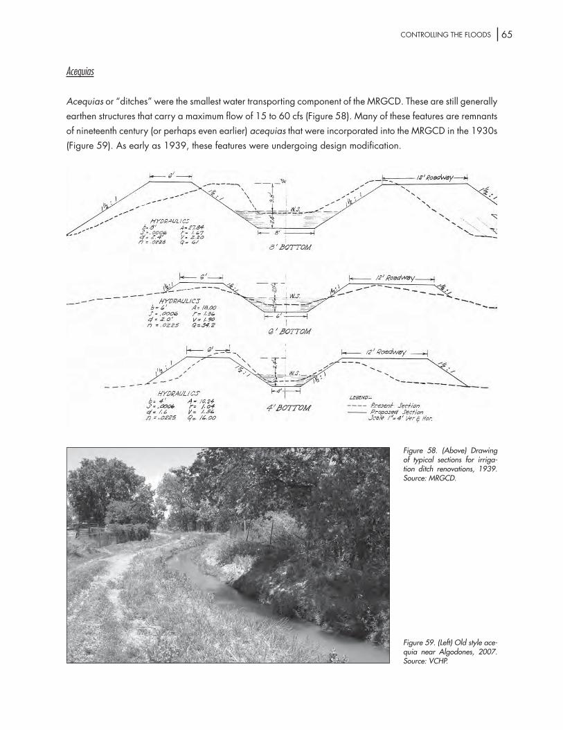
65Controlling the Floods
Acequias
Acequias or “ditches” were the smallest water transporting component of the MrgCd. these are still generally earthen structures that carry a maximum flow of 15 to 60 cfs (Figure 58). Many of these features are remnants of nineteenth century (or perhaps even earlier) acequias that were incorporated into the MrgCd in the 1930s (Figure 59). As early as 1939, these features were undergoing design modification.
Figure 58. (Above) Drawing of typical sections for irriga-tion ditch renovations, 1939. Source: MRGCD.
Figure 59. (Left) Old style ace-quia near Algodones, 2007. Source: VCHP.

66 ChAPter iVtyPes oF engineering strUCtUres Within the stUdy AreA
Canal and Lateral Features
the canals and laterals required a number of water control features to move water from the canals to the farm fields. these included: checks to hold back water in the canals, gates – which functioned similarly to checks – and farm turnouts to feed water into the acequias. Checks and gates were originally designed of wood, but were later fabricated from concrete and metal. they featured screw or ratchet lifts that were hand operated to open the gates (Ackerly et al. 1997, 148) (Figures 60 and 61). turnouts were metal gates that would slide in a steel frame and discharge into a metal pipe of 12, 15 or 18 inch diameter (Figures 62 and 63). the 1928 plan called for a turnout to be placed approximately every quarter mile on laterals and every half-mile when placed directly on a canal. the conservancy district anticipated a need for 3,000 of the turnout gates
(Burkholder 1928: 100).
Figure 60. (Above) Construction drawing of flash-board hoists for turnout, date unknown. Source: MRGCD.
Figure 61. (Left) Metal turnout on Old Jarales Acequia, 2007. Source: VCHP.

67Controlling the Floods
Figure 62. Metal turnout and precast concrete headwall installed on Old Jarales Acequia, 1957. Source: USBR.
Figure 63. Radial gate check on unidentified lateral in the Socorro Division, 1952. Source: USBR.

68 ChAPter iVtyPes oF engineering strUCtUres Within the stUdy AreA
Canals also featured a concrete lining, called a drop, that was placed where a canal changed grade and was designed to prevent erosion. Flumes were built to convey canal water over obstacles, such as drains or other ditches, and a number of bridges were constructed throughout the system to allow vehicles and pedestrians access to the canals, laterals, and drains (Ackerly et al. 1997, 148) (Figure 64). like other MrgCd features, most of these were originally constructed of wood and later replaced by concrete or steel
materials (Figure 65).
Drains
the engineering staff for the MrgCd designed two types of drains: (1) riverside drains and (2) interior drains. the system also has wasteways, which are shorter sections of drains that move excess water away from the fields and into the larger drains or the river. riverside drains were constructed alongside a levee and
Figure 64. Drawing of standard pipe flumes with timber substructure, 1930. Source: MRGCD.
Figure 65. Gallegos irrigation flume crossing the Alameda Interior Drain, 1930; Covered flume carrying irrigation water over the Alameda Interior Drain near Old Town, 1930. Source: MRGCD.

69Controlling the Floods
were formed as trenches were dug to provide material to build the levees (Figure 66). the riverside drains were designed to be 6 to 8 feet below ground level with a bed width of a minimum of ten to twenty feet and a slope of 1-½ :1 foot (Burkholder 1928:117). this type of drain was excavated below the groundwater level in order to catch subsurface water and seepage from the river. the water would then be returned to the river to continue its flow downstream (Figure 67).
Figure 66. Albuquerque Riverside Drain (left side of photo) looking south near Old Town, 1931. Note wooden footbridge across drain. Source: MRGCD.
Figure 67. Albuquerque Riverside Drain at the Griegos Heading, 1952. Source: USBR.

70 ChAPter iVtyPes oF engineering strUCtUres Within the stUdy AreA
interior drains were constructed to run through the irrigated fields and designed to drain away excess water. interior drains were designed to lower the water table by transporting subsurface water to riverside drains for eventual deposit into the river (Figure 68). the interior drains were wider and deeper than the riverside drains. they were eight to fourteen feet wide and built to a depth of ten feet as they ran through the fields and decreased in depth as the drain fed into the shallower riverside drain. the system was designed so that no field was farther than one half mile from an interior drain.
Figure 68. Alameda Interior Drain, looking north along Second St., 2007. Note water coming out of culvert from adjacent land formerly used for farm fields, but now built up with suburban housing. Compare with Figure 54. Source: VCHP.

71Controlling the Floods
V. EVALUATION OF NATIONAL REGISTER SIGNIFICANCE FORMRGCD ENGINEERING STRUCTURES AND FEATURES
this section will evaluate the historic significance of the engineering structures and features constructed by the MrgCd in accordance with the criteria set forth in the national register Bulletin for applying national register criteria (national Park service, 1997). Much of this discussion will incorporate the recommendation on historic significance and integrity of the MrgCd’s irrigation system made by Ackerly, et al (1997, 149-53) to the UsBr. this previous study focused on the district’s diversion dams, drains, canals, laterals, and acequias. no recommendations were made with regard to levees and channelization structures, such as jetty jacks. the present study will comment on Ackerly’s evaluation of significance for the irrigation system and include VChP’s evaluation for the structures not previously considered.
All the structures discussed are components of the original 1928 plan for the district (Burkholder 1928), and most were built between 1930 and 1941. Many of these structures have undergone subsequent modifications or alterations in design and materials, primarily between 1956 and 1963, as new technologies were developed and funding was made available to rehabilitate and upgrade the system. there have also been additional laterals and ditches constructed, and some laterals and drains abandoned, since that initial construction period; however, the MrgCd system itself remains relatively unchanged, and thus the conservancy district as a whole meets the “50 years or older” age criterion.
Ackerly’s report found none of the MrgCd structures or features individually eligible for the national register of historic Places (national register). VChP concurs with this finding and, in addition, finds that no individual levee structures or jetty jacks to be individually eligible. however, VChP agrees with the Ackerly report that the structures and features that comprise the MrgCd do constitute a historic district. According to the national register Bulletin (1997, 5): A district possesses a significant concentration, linkage, or continuity of sites, buildings, structures, or objects united historically or aesthetically by plan or physical development.
the diversion dams, canals, laterals, acequias, drains, and their associated appurtenances (headgates, turnouts, siphons, etc.), together with the levees and jetty jack fields, were conceived in 1928 and constructed over a ten year period (1930-40) to create an interconnected engineering system to enhance irrigation agriculture and control flooding along the middle rio grande valley. the MrgCd was planned from the beginning to work as a system in which all the major engineering structures played an integral and interrelated part in making the system work. Without any one of these structures, the system would have failed or at least would have been less effective. As such, these engineering structures and features should be considered contributing elements to the historic district.

72 ChAPter VeVAlUAtion oF nAtionAl register signiFiCAnCe
in accordance with national register guidelines, “A district must be significant, as well as being an identifiable entity.” the district’s historic significance must be considered under the national register criteria discussed in the Bulletin (1997, 12-24). VChP concurs with the Ackerly report that the MrgCd is eligible for the national register under Criterion A: Properties associated with events that have made a significant contribution to the broad patterns of our history. specifically, the district is eligible under the areas of significance pertaining to agriculture and, to a lesser extent, engineering (this qualification will be explored below).
As noted by Ackerly, et al (1997, 150): “[t]he creation of the MrgCd [is an] important chapter in a long-term historic trend from numerous, small-scale, locally managed acequias to a single, large-scale, centrally planned system whose waters are allocated at the interstate level.” the conservancy district was part of the historical trend of irrigation agriculture in the Western United states that emphasized water management and control and the reclamation of previously undeveloped land. the MrgCd was unique, however, in that it built upon an existing, small-scale system developed in spanish Colonial (and perhaps even pre-Columbian) times that had fallen into disrepair and failing environmental conditions. so, in addition to reclaiming previously unused “desert lands,” the MrgCd rehabilitated and rejuvenated existing farmlands. the district followed a common pattern of transitioning from individually managed, small-scale ditch systems, to larger systems backed by large capital investment to the seemingly inevitable involvement of the Federal government for not only capital improvements, but management of the system. the result was the doubling of cultivated acreage and the elimination of environmental problems such as seepage and alkali buildup. the MrgCd also concerned itself with flood control on the rio grande, which of course was intimately tied to the valley’s agricultural practices, but in addition was a major factor in the city of Albuquerque’s urban development during the 1930s and following World War ii.
the significance of the MrgCd with historic engineering themes has been compromised by the rehabilitation of the system by the UsBr and the UsACe in the 1950s and 60s. At that time many of the original features, often made of wood, were replaced with concrete and steel materials. on the other hand, the system itself retains its original design and function, albeit with new component materials. it is still a relatively simple, hand-operated, gravity-fed irrigation system. For this reason, the system, together with its contributing elements, still maintains a sense of its engineering history; however, strictly speaking the modifications made to the structures and features have negated its significance with regard to Criterion C: Properties that embody the distinctive characteristics of a type, period, or method of construction. in other words, the MrgCd system is still identified with the irrigation history of the rio grand valley, and thus eligible under Criterion A, but substantial modifications to the individual structures prevent the MrgCd from being eligible for its identification with specific historical agricultural engineering solutions under Criterion C (see also discussion in Ackerly 1997, 152).
in addition to historical significance, to be considered eligible for the national register a district must retain integrity, which, as defined by the national register Bulletin, means “the ability of a property [or district] to convey its significance” (1997, 44). the Bulletin defines seven aspects of integrity to be considered: location, design, setting, materials, workmanship, feeling, and association.

73Controlling the Floods
the MrgCd essentially retains its integrity with regard to location, design, and setting. the conservancy district has not substantially relocated the basic structures and features that make up the irrigation and flood control system. Although some individual canals, laterals, ditches, and drains have been added, relocated, or abandoned over the past seventy-five years, the system itself is still in the same location as designed. similarly, the design of the system has not been altered. it is still a gravity-fed irrigation system in which the headgates and turnouts are still manually operated. Again, although some of these individual features have been replaced with new materials, the functioning of the system is still the same as when designed in 1928. the setting of the MrgCd, especially outside the metropolitan Albuquerque area, is still predominately rural as it was at the time of the project’s inception. Urbanization, in the form of commercial properties and housing subdivisions, have intruded upon this landscape, particularly in the area immediately north and south of the city; however, it should be remembered that this urban “sprawl” was already underway in Albuquerque’s north Valley when construction of the MrgCd was started.
the MrgCd lacks integrity in the aspects of materials, workmanship, feeling, and association. this is due primarily to the rehabilitation of the system undertaken following the second World War. Many of the original earthen irrigation ditches were lined with concrete to prevent seepage and wood water control structures were replaced by ones made of concrete and steel. this modernization of materials altered the historic qualities of these structures in regard to their workmanship, and consequently resulted in the loss of feeling and association of the engineering designs used to construct the original structures in the 1930s (see also Ackerly 1997, 151-52).
the Ackerly report (1997, 152) summarizes the argument in favor of integrity as follows: “in summary, the MrgCd system completed in 1936 is eligible to the national register of historic Places because it is associated with the important events in local history and retains the ability to convey that historic significance, but not as an important example of historic engineering design.” VChP agrees with the Ackerly report that the totality of the MrgCd system, including both the irrigation system and flood control structures, still retains its overall integrity through its identification with the history of agriculture in the middle rio grande valley, and for its contribution to the development of the city of Albuquerque. it is VChP’s recommendation that the levees and jetty jacks, as well as the irrigation system features previously identified in the Ackerly report, are eligible as contributing elements to the historic district under Criterion A.

74 ChAPter VeVAlUAtion oF nAtionAl register signiFiCAnCe

75Controlling the Floods
VI. MANAGEMENT RECOMMENDATIONS FOR THE LEVEES AND JETTY JACKSAS CONTRIBUTING ELEMENTS TO THE HISTORIC DISTRICT
the Ackerly report (1997, 152-53) addresses the issue of managing the contributing elements that make up the MrgCd historic district. the authors note that the district is eligible under Criterion A, and not Criterion C, and, therefore, to avoid effects on the integrity of the system “it is not necessary to preserve specific engineering solutions if the overall ability of the system to convey its historic importance is preserved.” For example, while the infilling of the main canals would have an adverse effect on the district’s ability to convey the history of the conservancy district, the replacement of a turnout, check, bridge would not have such an effect on the district’s historic integrity.
VChP agrees with this conclusion, and also supports the finding by Ackerly et al. that the best action to be taken to protect the district would be a multi-agency programmatic agreement (PA), including the UsACe, the UsBr, and the MrgCd, that would stipulate those contributing elements which would require consultation under section 106 of the nhPA and those which could be programmatically excluded from the review process as long as the proposed undertaking was in conformance with the PA.

76 ChAPter ViMAnAgeMent reCoMMendAtions

77Controlling the Floods
REFERENCES CITED
Ackerly, neal W.1996 A Review of the Historic Significance of and Management Recommendations for Preserving
New Mexico’s Acequia Systems. santa Fe: historic Preservation division.
Ackerly, neal W., david A. Phillips, Jr., and Kevin (lex) Palmer1997 “the development of irrigation systems in the Middle rio grande Conservancy district Cen-
tral new Mexico: A historic overview.” sWCA Archaeological report number 95-162, sWCA, inc. environmental Consultants, Albuquerque, new Mexico. Usdi, Bureau of recla-mation, Albuquerque Area office.
Adams, eleanor B., and Fray Angelico Chavez, eds. and trans.
1956 The Missions of New Mexico, 1776: A Description by Fray Francisco Atanasio Dominguez. Albuquerque: University of new Mexico Press.
Anschuetz, Kurt F. 1984 Prehistoric Change in tijeras Canyon, new Mexico. Unpublished M.A. thesis, University of
new Mexico, Albuquerque.
1995 “saving for a rainy day: the integration of diverse Agricultural technologies to harvest and Conserve Water in the lower rio Chama Valley, new Mexico.” in Soil, Water, Biology, and Belief in Prehistoric and Traditional Southwestern Agriculture, edited by h. W. toll, pp. 25-39. Albuquerque: new Mexico Archaeological Council, special Publication no. 2.
Bartolino, James r., and James C. Cole
2002 Ground-Water Resources of the Middle Rio Grande Basin. U.s. geological survey, Circular 1222, Washington, d.C.
Bayer, laura, Floyd Montoya, and the Pueblo of santa Ana1994 Santa Ana: The People, Pueblo, and the History of Tamaya. Albuquerque: University of new
Mexico Press.
Beadle, J. h.1973 The Undeveloped West: or, Five Years in the Territories. new York: Arno Press.
Berry, K. lynn, and Karen lewis1997 Historical Documentation of Middle Rio Grande Flood Protection Projects, Corrales to San
Marcial. Albuquerque: office of Contract Archaeology, University of new Mexico.

78 reFerenCes Cited
Biebel, Charles d.1986 Making the Most of it: Public Works in Albuquerque During the Great Depression, 1929-
1942. Albuquerque: the Albuquerque Museum.
Burkholder, Joseph l.1928 Report of the Chief Engineer. Submitting a Plan for Flood Control, Drainage and Irrigation of
the Middle Rio Grande Conservancy Project, 3 volumes Albuquerque: Middle rio grande Conservancy district.
Carlson, Alvar W.1975 “long-lots in the rio Arriba.” Annals of the Association of American Geographers, Vol. 65,
no. 1(March): 48-57.
1990 The Spanish-American Homeland: Four Centuries in New Mexico’s Rio Arriba. Baltimore: Johns hopkins University Press.
Carter, r. h.1953 An historical study of Floods Prior to 1892 in the rio grande Watershed, new Mexico.
Unpublished M.A. thesis, University of new Mexico, Albuquerque.
Chapman, richard C., and Jan. V. Biella, eds.1977 Archaeological Investigations in Cochiti Reservoir, New Mexico, 4 volumes Albuquerque:
office of Contract Archaeology, University of new Mexico.
Clark, ira g.1987 Water Use in New Mexico. Albuquerque: University of new Mexico Press.
Cordell, linda s.1984 Prehistory of the Southwest. new York: Academic Press.
Cozzens, samuel Woodworth1988 Explorations & Adventures in Arizona & New Mexico. secaucus, nJ: Castle.
Crawford, stanley1988 Mayordomo. Chronicle of an Acequia in Northern New Mexico. Albuquerque: University of
new Mexico Press.
dale Bellamah land Co.1950 “the dietz Farm story.” Unpublished promotional brochure on file at the Center for south-
west research, Zimmerman library, University of new Mexico.
damp, Jonathan e., hall, stephen A., susan J. smith 2002 “early irrigation on the Colorado Plateau near Zuni Pueblo, new Mexico.” American Antiq-
uity, vol. 67, no. 4: 665-676.

79Controlling the Floods
earls, Amy Clair1985 the organization of Piro Pueblo subsistence: A.d. 1300 to 1680. Unpublished Ph.d. dis-
sertation, University of new Mexico, Albuquerque.
everhart, gregory d. 2004 documentation of Cultural resources for the Albuquerque Biological Park’s tingley Pond and
Wetland restoration Project in Albuquerque, Bernalillo County, new Mexico. report no. Coe-2003-03 nMCris report no. 83240. laboratory of Anthropology, Museum of new Mexico.
grassel, Kathy2002 Taking Out the Jacks. Issues of Jetty Jack Removal in Bosque and River Restoration Planning.
Project report, Water resources Program, University of new Mexico.
gregg, Josiah (Max l. Moorhead, ed.) 1954 Commerce of the Prairies. norman: University of oklahoma Press.
grieser, s. t., and J. l. Moore1995 “the Case for Prehistoric irrigation in the northern southwest.” in Soil, Water, Biology, and
Belief in Prehistoric and Traditional Southwestern Agriculture, edited by h. W. toll, pp. 187-195. Albuquerque: new Mexico Archaeological Council, special Publication no. 2.
haury, emil W.1967 “the hohokam, First Masters of the American desert.” National Geographic, vol. 131: 670-
695.
hill, J. Brett, 1998 “ecological Variability and Agricultural specialization among the Protohistoric Pueblo of
Central new Mexico.” Journal of Field Archaeology, Vol. 25, no. 3. (Autumn,): 275-294.
Kammer, david1997 “the twentieth-Century suburban growth of Albuquerque, new Mexico.” national regis-
ter of historic Places Multiple Property documentation Form. national Park service, Wash-ington d.C.
lagasse, Peter F.1980 An Assessment of the Response of the Rio Grande to Dam Construction - Cochiti to Isleta
Reach. Albuquerque: U.s. Army Corps of engineers, Albuquerque district.
lange, Charles h.1959 Cochiti: A New Mexico Pueblo, Past and Present. Austin: University of texas Press.

80 reFerenCes Cited
lucero, Brian luna2007 “old towns Challenged by the Boom town. the Villages of the Middle rio grande Valley
and the Albuquerque tricentennial.” New Mexico Historical Review, vol. 82, no. 1 (Winter): 37-69.
Mabry, J. B., d. l. swartz, h. Wöcherl, J. J. Clark, g. h. Archer, and M. W. lindeman 1997 Archaeological Investigations on Early Village Sites in the Middle Santa Cruz Valley. Anthro-
pological Papers no. 18.tucson: Center for desert Archaeology.
Marshall, Michael P.1979 Excavations at Nuestra Señora de Dolores Pueblo (LA 677), A Prehistoric Settlement in the
Tiguex Province. Albuquerque: office of Contract Archaeology, University of new Mexico.
Masse, W. B.1981 “Prehistoric irrigation systems in the salt river Valley, Arizona.” Science, vol. 214: 408-
415.
Mcnitt, Frank1964 Navaho Expedition: Journal of a Military Reconnaissance from Santa Fe, New Mexico to
the Navaho Country Made in 1849 by Lieutenant James H. Simpson. norman: University of oklahoma Press.
Middle rio grande Flood Control Association1950 The Facts About the Flood Control and Reclamation Project in the Middle Rio Grande Val-
ley and Its Importance in the National Defense Program. Unpublished booklet, Zimmerman library, University of new Mexico.
Molles, Manuel C., Jr., Clifford s. Crawford, lisa M. ellis, h. Maurice Valett, and Clifford n. dahm 1998 “Managed Flooding for riparian ecosystem restoration.” BioScience, vol. 48, no. 9: 749-
756.
Moore, J. l.1995 “Prehistoric irrigation at Pot Creek Pueblo.” in Soil, Water, Biology, and Belief in Prehistoric
and Traditional Southwestern Agriculture, edited by h. W. toll, pp. 209-220. Albuquerque: new Mexico Archaeological Council, special Publication no. 2.
nanninga, r. s.1982 “Middle rio grande Valley Prior to the Advent of the Conservancy district.” in Albuquerque
Country II, New Mexico Geological Society Guidebook, edited by J. A. grambling and s. g. Wells, pp. 99-101. new Mexico geological society, thirty-third Annual Field Confer-ence, Albuquerque.

81Controlling the Floods
national Park service1997 “how to Apply the national register Criteria for evaluation.” National Register Bulletin (re-
vised ed.), Washington, d.C.: department of the interior.
new Mexico office of the state engineer1967 Water Resources of New Mexico: Occurrence, Development and Use. santa Fe: state Plan-
ning office.
2007 rio grande Compact. http://www.ose.state.nm.us/isc_rio_grande_compact.html.
Poore, henry r.1894 “Condition of the Pueblos in new Mexico in 1890. in Extra Census Bulletin: Moqui Pueblo
Indians of Arizona and New Mexico, pp. 99-119. Washington, d.C.: Census office, de-partment of the interior.
reisner, Marc 1993 Cadillac Desert: The American West and its Disappearing Water. new York: Penguin
Books.
ritter, Barbara A.2000 the Formation of the Middle rio grande Conservancy district: looking Back at hispano
Protests, 1925-1944. Master’s thesis, University of new Mexico, Albuquerque.
sando, Joe s.1992 Pueblo Nations: Eight Centuries of Pueblo Indian History. santa Fe: Clear light Publishers.
sargeant, Kathryn, and Mary davis1986 Shining River, Precious Land: An Oral History of Albuquerque’s North Valley. Albuquerque:
the Albuquerque Museum.
schroeder, Albert, and dan s. Matson 1965 A Colony on the Move: Gaspar Castano de Sosa’s Journal, 1590-1591. santa Fe: school
of American research.
scurlock, dan 1988 “the rio grande Bosque: ever Changing.” New Mexico Historical Review, vol. 63, no. 2:
131-40. 1998 From the Rio to the Sierra: An Environmental History of the Middle Rio Grande Basin. Fort Col-
lins, Co: U.s. department of Agriculture, Forest service rocky Mountain research station.
simmons, Marc1972 “spanish irrigation Practices in new Mexico.” New Mexico Historical Review, vol. 47, no.
2: XXX.

82 reFerenCes Cited
1982 Albuquerque: A Narrative History. Albuquerque: University of new Mexico. 1991 Coronado’s Land: Essays on Daily Life in Colonial New Mexico. Albuquerque: University of
new Mexico Press.
sorenson, earl F., and dee linford1967 “settlement, development, and Water Use.” in Water Resources of New Mexico: Occur-
rence, Development and Use, pp. 143-68. santa Fe: new Mexico state engineer, state Planning office.
U.s. Army Corps of engineers2004 the Albuquerque Biological Park Wetland restoration Project. UsACe: Albuquerque dis-
trict.
U.s. Bureau of reclamation1955 Middle rio grande Project, Albuquerque, new Mexico. Project history 1955. United states
department of the interior, Bureau of reclamation.
Vivian, r. gwinn1974 “Conservation and diversion: Water-Control systems in the Anasazi southwest.” in Irriga-
tion’s Impact on Society, edited by t. e. downing and M. gibson, pp. 95-112. University of Arizona Anthropological Papers no. 25, tucson.
Waters, M. r. and J. C. ravesloot2001 “landscape Change and the Cultural evolution of the hohokam along the Middle gila river
and other river Valleys in south Central Arizona.” American Antiquity, vol. 66: 285-299.
Weber, david 1992 The Spanish Frontier in North America. new haven: Yale University Press.
Welsh, Michael e.1987 U. S. Army Corps of Engineers: Albuquerque District, 1935-1985. Albuquerque: University
of new Mexico Press.
Wheeler, stephen M., and Wade Patterson2007 “the rise of the regional City. spatial development of the Albuquerque Metropolitan Area.”
New Mexico Historical Review, vol. 82, no. 1 (Winter): 1-36.
Wilson, Chris1996 “Auto-oriented Commercial development in Albuquerque, new Mexico, 1916-1956.”
national register of historic Places Multiple Property documentation Form. national Park service, Washington d.C.

83Controlling the Floods
Wilson, herbert M. 1898 “relations of irrigation to geography.” Journal of the American Geographical Society of
New York, vol. 30, no. 1.
Wislizenus, Frederick A.1969 Memoir of a Tour to Northern New Mexico, connected with Col. Doniphan’s Expedition, in
1846 and 1847. glorieta, nM: rio grande Press.
Woodbury, richard B.1961 “A reappraisal of hohokam irrigation.” American Anthropologist, vol. 63, no. 3: 550-
560.
Woodson, robert C.1961 “stabilization of the Middle rio grande in new Mexico.” Journal of the Waterways and
harbors division, Proceedings of the American Society of Civil Engineers, Vol. 87, no. WW 4, november.
Woodson, robert C., and John t. Martin1963 “the rio grande Comprehensive Plan in new Mexico and its effects on the river regime
through the Middle Valley.” in Proceedings of the Federal Interagency Sedimentation Confer-ence, Jackson, Ms.
Worcester, donald1979 “significance of the spanish Borderlands. ”in New Spain’s Far Northern Frontier, edited by
david J. Weber. Albuquerque: University of new Mexico Press.
Wozniak, Frank e.1998 Irrigation in the Rio Grande Valley, New Mexico: A Study and Annotated Bibliography of the
Development of Irrigation Systems. Fort Collins, Co: UsdA Forest service, rocky Mountain research station.
Yeo, herbertn.d. data on rio grande Floods Prior to 1943. Manuscript on file at the U.s. Army Corps of
engineers, Albuquerque district.

84 reFerenCes Cited


