44
Copyright 2008 Coast Guard Auxiliary Association, Inc. The Weekend Navigator Basic Level I
| Date post: | 31-Dec-2015 |
| Category: |
Documents |
| Upload: | moris-stewart |
| View: | 214 times |
| Download: | 0 times |

Copyright 2008 Coast Guard Auxiliary Association, Inc.
The Weekend Navigator
Basic Level I

Chapter 5: Planning With GPS and Paper Charts

Chapter 5: Lesson Objectives
• Criteria for a safe course
• Steps in pre-voyage planning
• Plotting on a chart
• Entering waypoints into your GPS

Planning and Paper Charts
• Make sure you use the latest version of the charts for your area of operation!

Criteria for a Safe Course
• Determining safe depths– Characteristics of your boat– Characteristics of the seabed
• Sounding is measurement of the bottom depth at a particular location
• Contour lines can be drawn for constant depths

Criteria for a Safe Course
• All soundings are referenced to a standard datum– Mean lower low water (MLLW)– Each sounding represents the shallowest water
for that particular location

Criteria for a Safe Course• Draft is the measure of how far a boat’s keel or
drive unit extends below the waterline

Criteria for a Safe Course
• Determining an adequate safety margin depends on:– Type of seabed– Likely sea conditions– Characteristics and vulnerabilities of your boat

Criteria for a Safe Course
• Isolated hazards can be natural or man-made – Outlying rocks (exposed, covered, covering)– Wrecks– Old pilings

Criteria for a Safe Course• Shoals are the tops of underwater hills that
may lie along a line
• Main channels may run parallel to shoals

Criteria for a Safe Course• Horizontal clearance provides adequate room
to steer around obstacles
• Intended path - ten times wider than GPS error to either side (i.e. error of 50 feet for most units)– One-tenth of a minute of latitude is equivalent to
600 feet and can also be used

Criteria for a Safe Course
• Overhead clearance is the vertical clearance between the water level and an overhead object– Bridges and overhead cables
• Make sure to include antennas, radar, outriggers poles in your vertical clearance calculations!

Criteria for a Safe Course
• Overhead clearances – referenced to mean high water (MHW) – or mean higher high water (MHHW)

Steps in Pre-voyage Planning
• First: Locate home port and ports to visit
• Second: Locate hazards
• Third: Plot straight line paths to points of interest
• Fourth: Invent short names for connecting waypoints

Steps in Pre-voyage Planning
• Fifth: Note any landmarks
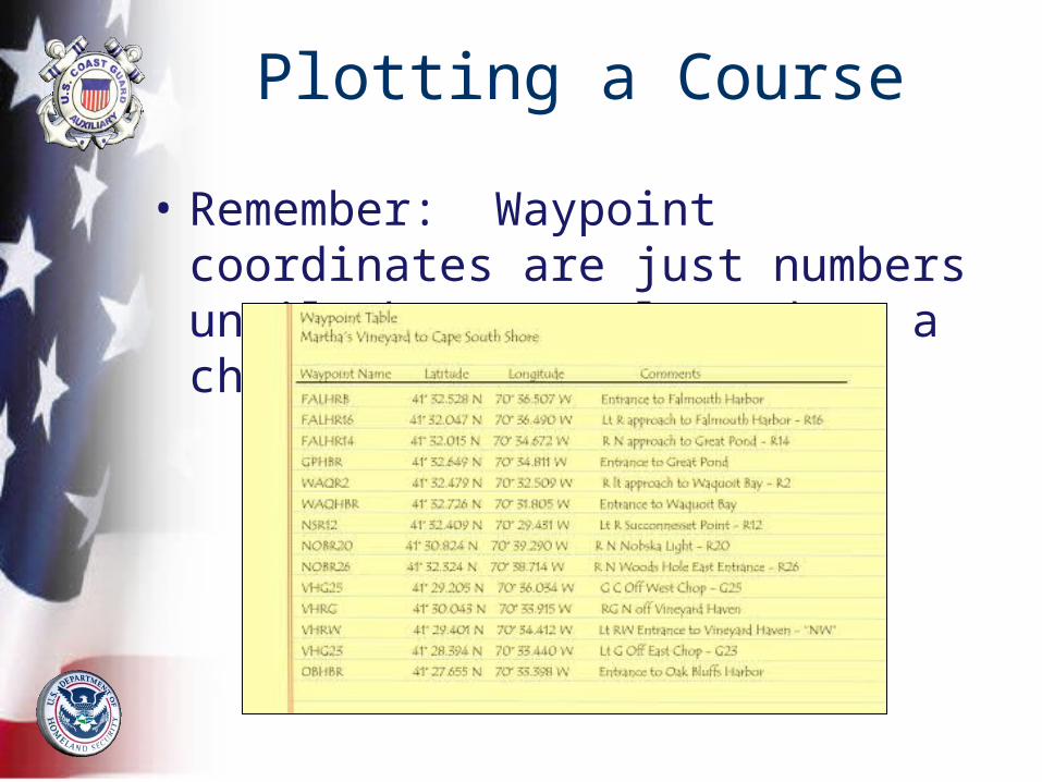
• Sixth: Measure coordinates of each waypoint
• Seventh: Complete waypoint table and enter into GPS

Steps in Pre-voyage Planning

Creating Routes
• Select waypoints in a particular sequence to create a desired route

Plotting on a Chart
• Thoroughly annotate your paper charts with the information stored in your GPS
• Summary of Plotting Lines– Course lines– Range lines– Dead Reckoning (DR)– Bearing lines

Plotting a Course • Draw straight line segments on the chart to
avoid obstacles
• Measure the coordinates of the end points of each leg

Plotting a Course
• Course legs should labeled using navigation conventions– C for course followed by three digit direction– M for magneticExample: – A course of 3o should be labeled “C 003 M”– Label is placed near the waypoint above the
course line


Plotting a Course
• Distance of a leg starts with the letter “D” and then the distance
• Distance label is placed under the line and near the center of the leg
• Example: “D 2.6”

Plotting a Course
• Remember: Waypoint coordinates are just numbers until they are plotted on a chart!

Plotting a Course
• A reciprocal is the course you would steer if you came from the exact opposite direction– To determine a reciprocal, either add 180o to a
course less than 180o or subtract 180o from a course more than 180o
• The reciprocal course heading is noted at the other end of each line

Plotting a Course
• Example Problems:
• What is the reciprocal of 043?
• What is the reciprocal of 187?

Plotting a Course
• The reciprocal for 043 would be 43o + 180o = 223o
• The reciprocal for 187 would 187o – 180o = 007o

The Compass Rose • Provides the chart’s fundamental reference
for magnetic directions
• Outer ring aligns with the chart grid of latitude and longitude or true north
• Inner ring aligns with magnetic north

The Compass Rose

The Compass Rose • Variation describes both the:
– Magnitude of the difference in degrees and minutes between true and magnetic north
– Direction of the offset either east or west
• Includes the date used for the variation and the annual change


Using the Chart Grid and Protractor Plotting Tool
• It is easier to plot courses and bearing in degrees magnetic instead of degrees true
• You should be able to do both

Adding or Subtracting Local Variation
• Add westerly variation to your true course
• Subtract easterly variation from your true course

Adding or Subtracting Local Variation
• Examples:– Local variation =15o W
– True course= 175
– What is your magnetic course?
– 175 T + 15o W = 190 M
– If local variation = 15o E
– What is your magnetic course?
– 175 T– 15o E = 160 M

Correcting for Deviation
• Deviation – compass error or the difference between your
compass and magnetic north
• Compass deviation is unique to each boat while variation is consistent within a given area

Correcting for Deviation
• T = True direction
• V = Local variation
• M = Magnetic direction
• D = Deviation of the compass
• C = Compass direction

Correcting for Deviation
• Converting from true to magnetic– Add westerly variation and subtract easterly
variation
• Converting from magnetic to true– Add easterly variation and subtract westerly
variation

Correcting for Deviation
• Converting from magnetic to compass– Add westerly deviation and subtract easterly
variation
• Converting from compass to magnetic– Add easterly deviation and subtract westerly
variation

Copyright 2006 Coast Guard Auxiliary Association, Inc.
Correcting for Deviation
• True and magnetic directions are used for plotting
• Compass courses are used for steering the boat and are not plotted

Plotting a Bearing • A bearing is a line of position and represents
a line on which your boat is located
• The object, not your boat, is used as the reference point,

Plotting a Bearing
• The bearing line is drawn:– Toward the object– Direction of the bearing– Estimated location of your boat– Labeled with 24 hour clock (4 digits) above the line and
direction of bearing (3 digits) below the line


Plotting a Range
• Plotted as straight dashed lines between charted objects with the line extending to the navigation area
• Bearing is placed on top of the line
• Water towers, church spires, and day beacons may be used as ranges

Summary
• Criteria for a safe course
• Steps in pre-voyage planning
• Plotting on a chart
• Entering waypoints into your GPS


