272
Copyright by Sofia Laparidou 2016

Copyright
by
Sofia Laparidou
2016

The Dissertation Committee for Sofia Laparidou Certifies that this is the approved
version of the following dissertation:
The Political Ecology and Resilience of Medieval Peasant Communities
in the Southern Levant: Micro-botanical Perspectives
Committee:
Arlene Rosen, Supervisor
Kamran Asdar Ali
Enrique Rodriquez Alegria
Bethany Walker

The Political Ecology and Resilience of Medieval Peasant Communities
in the Southern Levant: Micro-botanical Perspectives
by
Sofia Laparidou, PYTICHO (B.A.); M.S.; M.S.
Dissertation
Presented to the Faculty of the Graduate School of
The University of Texas at Austin
in Partial Fulfillment
of the Requirements
for the Degree of
Doctor of Philosophy
The University of Texas at Austin
May 2016

Dedication
For my Mother and my Father

v
Acknowledgements
"As you set out for Ithaka hope your road is a long one, full of adventure, full of
discovery... Hope your road is a long one... Keep Ithaka always in your mind. Arriving
there is what you’re destined for. But don’t hurry the journey at all. Better if it lasts for
years, so you’re old by the time you reach the island, wealthy with all you’ve gained on
the way, not expecting Ithaka to make you rich. Ithaka gave you the marvelous journey.
Without her you wouldn’t have set out. She has nothing left to give you now. And if you
find her poor, Ithaka won’t have fooled you. Wise as you will have become, so full of
experience, you’ll have understood by then what these Ithakas mean."
This is the end of a very important and beautiful journey. The road was a long one
and all throughout I kept "Ithaka" in my mind. All those years I was fortunate enough to
work on all that excited my heart, on all that excited my thirst for knowledge and
satisfied my mind. But at the same time all throughout that journey I learned about
myself and realized my potential. All this would have not been possible without the
support of my beloved supervisor, friends, colleagues and my family. I would like to
thank all of you that helped me reach this "Ithaka".
I started my Ph.D. in London, at the Institute of Archaeology (University College
London). I will always remember the first day that I met my supervisor, Prof Arlene
Rosen. She was so welcoming, so polite, so inspiring and that day I knew that this
journey is all worth it. I would like to thank Arlene Rosen for her constant advice and
guidance. She guided me always with patience and care and excited my thirst for
knowledge, because of her own inner thirst for knowledge and the power of her mind and

vi
soul. I would like to thank Steve Rosen as well for always being there for me and helping
me throughout my whole Ph.D. as a mentor and friend. Thank you Steve for showing up
to almost all my presentations, for your advice, guidance and support!
I would like thank all of my committee members at UCL, who assisted me and
inspired me to begin that journey: Dorian Q. Fuller, Andrew Garrard, Mark Altaweel and
so many more wonderful colleagues and mentors that I was so fortunate to meet. I would
like to thank Louis Martins, Cyprian Broodbank and Sandra Bond for always being so
helpful and so kind to me. I would like to thank all my office and lab friends at UCL as
well. Special thanks to Ellie Kingwell, Anke Marsh and Phip Ryan for training me in
phytolith analyses and for being good friends. Special thanks to Andrea Squtieri, Anna
Spyrou (ευχαριστω πολυ για ολα), Chiarra Bonachi, Eugenio Bartolini, Alessio
Palmisano, Isabel Rivera-Colazo, Leilani Lucas (so thankful for meeting you...), Enrico
Crema, Alice Hunt, Rebecca Beardmore, Hania Sosnowska, and for all our friends on the
Environmental Archaeology floor... You have made my life very special there. Special
thanks to my friend Virginia McRostie for being a friend and my family at UCL. There
are not enough words to thank her.
In the Department of Anthropology at the University of Texas at Austin, I would
like to express my gratitude to so many colleagues and friends. First of all, I would like to
thank my advisor Arlene Rosen for bringing me all the way to Texas. I would like to
thank my Ph.D. committee members for all their efforts, guidance and constant support:
Kamran Ali, Enrique Rodriguez-Alegria, Prof. Karl Butzer, and Bethany Walker.
Kamran, I have been so fortunate to come to UT Austin, and study Anthropology with
you! You have introduced me to the world of social and anthropological theory in the
best possible way. Thank you for being You: a very inspiring mentor, very
knowledgeable professor and a very good and kind friend to me and to all your students. I

vii
would like to thank Enrique for his advice and guidance and for always being there...I
would like to extend my special gratitude and appreciation to Prof. Karl Butzer. He was
more than a mentor, more than a supervisor to me and I have learned so much from him,
which are invaluable. I was so blessed to come to Texas and work with such a perceptive,
polite, brilliant and inspiring Professor. The Department of Anthropology at the
University of Texas at Austin is a unique academic environment and I have been
fortunate to meet so many unique and important colleagues who have been inspiring
mentors and professors. Thank you Sofian Merabet, John Hartigan, I would like to
specially thank Prof. Denbow for always being there for me. I would like to thank the
staff of the Department of Anthropology, Rolee Rios, Adriana Digman, Catherine
Schreiner, Karla Steffen, Chris McNett, Billy O'Leary for being so kind, helpful and for
making my life in Austin and the Department so wonderful.
I would like to thank my friends and colleagues, Monica Ramsey and Jinok Lee,
for making my time in the lab always a bless and for being such nice friends and provide
me with great support.
Also, I would like to thank my wonderful community of friends here at the
Department of Anthropology at the University of Texas at Austin. I would not be able to
make it without them. I owe this dissertation to all of you. Thank you Ani Vasudevan,
Ece Saltan, Amely Martins, Christina Gonzalez, Omer Ozcan, Cagri Yoltar, Deina Rabie,
Joey Russo, special thanks to all of you, you are my special family. Thanks to Ayca
Arkilic, Maya Berry, Christopher Farrell, Ayana Flewellen, Nedra Lee, Saikat Maitra,
Traci Ann-Wint, Hannah Foster, William Gblerkpor, Danielle Good, Amber Heard,
Sarah Ihmood, Addison Kemp, Noe Lopez, Ingrid Lundeen, Quichi Patlan, Jaime Mata-
Martinez, Alexander Menaker, Ana Maria Navas Mendez, Vasilina Orlova, Cofi Nutor,
Nicol Payntar, Daniel Perera, Tathagathan Ravindran, Monique Ribeiro, Morgan Siewert,
viii
Nora Tyelkar, Silvy Van Kuijk, Elizabeth Velasquez, Camille Weinberg, Luciane
O'Rocha, Chelsi West, Luisa Aebersold, Alison Damick, and to many more of our
friends. Every word, every smile, every hug you have shared with me mattered and made
my life in Austin so beautiful. Thank you to my Greek family in Austin: Apostolis
Psaros, Kostas Belivanis, Yiorgos Zalahoris, Michalis Hajiioannou, Manolis Karantinos,
and Angeliki Kalamara-Cavazos and her lovely family for being there for me.
This dissertation would not have been possible without the help of my colleagues
in Jordan and without the support and guidance of Bethany Walker, my friend, colleague
and committee member. Thank you Bethany for your important work on the historic
documents relevant to this research and your constant guidance and support. Special
thank you to Prof LaBianca and to all our colleagues and friends of the Tell Hisban
Archaeological Project; to Chris Tuttle, Susan Alcock and Micaela Sinibali and all
members of the Brown University Petra Archaeological Project; to Dinos Politis for all
his help and thanks to our wonderful team at Safi; to Alan Walmsley and Ian Simpson
and the Islamic Jerash Project; to the Department of Antiquities of Jordan; to the
American Centre for Oriental Research in Amman and special thanks to Barbara Porter;
to Zakariya Ben Badhann and Prof. Shdaifat and the team at Shuqayra al-Gharbiyya.
Finally I would like to thank my family. I express my special gratitude to my
Father who supported me all throughout my graduate studies, in any possible way, with
constant care and love. I express my special gratitude to my Mother, who made me the
person I am today and who taught me to love my work so much and to be able to love so
much in life overall. And special thanks to Arlene Rosen, she gave me the confidence to
believe what I already knew. Many special thanks to my dearest family, sister, cousins,
uncles and aunts who provided me with their support, love and care all those years.
Thank you to all!

ix
The Political Ecology and Resilience of Medieval Peasant Communities
in the Southern Levant: Micro-botanical Perspectives
Sofia Laparidou, Ph.D.
The University of Texas at Austin, 2016
Supervisor: Arlene Rosen
Peasant and rural society is a new focus of medieval Islamic archaeology in
Jordan. New surveys and excavations conducted on geographically and historically
distinct regions of Jordan consider state-level agricultural investment but are also
interested in documenting rural life and land use in medieval Jordan. This new research is
relevant to the discourse on medieval Political Ecology of Jordan because of its focus on
state investment in intensive land use, including irrigation and diversion of local
agricultural economies from subsistence crops to cash crops and the effects that state
agriculture had on peasantry and the environment. Archaeology offers a deep-time
perspective on these issues. In this dissertation, I use phytoliths to understand agricultural
practices of Medieval Jerash, Hisban (Mediterranean vegetation zone), Shuqayra al-
Gharbiyya, Tawahin as-Sukkar, Khirbet as-Sheikh Isa, and Beidha (semi-arid region of
the Jordan Valley) to offer new insights into state agricultural policies in relation to
ecological and environmental history. My results show that control of irrigable land by
subsistence farmers gave them resilience and contributed to sustainable farming.
However, state-managed agricultural systems expropriated irrigable land, emphasizing
production of cash crops for state revenue, thus reducing sustainability and putting

x
pressure on the landscape. Sugarcane production replaced cereal cultivation and led to
wood fuel burning, which in turn resulted in landscape erosion. Phytoliths from Beidha
indicate that intensive agricultural production extended to marginal areas with the use of
irrigation, thus creating greater human impact on sensitive environments.
xi
Table of Contents
List of Tables .........................................................................................................xv
List of Figures ...................................................................................................... xvi
Chapter 1: Introduction ........................................................................................1
Rural Islamic Archaeology of Jordan ....................................................4
Proposed research and methodology .....................................................7
BACKGROUND AND PREVIOUS WORK ON MEDIEVAL LAND-USE IN
TRANSJORDAN: POLITICAL ECOLOGIES OF MEDIEVAL PEASANTS IN
TRANSJORDAN .......................................................................................8
CLIMATE IN THE TRANSJORDAN DURING THE LATE HOLOCENE .................9
FARM-AGRICULTURAL ECONOMY AND RISK BUFFERING AGRICULTURAL
PRACTICES OF PEASANTS: NEW DIRECTIONS OF RESEARCH IN THE
POLITICAL ECOLOGY OF MEDIEVAL TRANSJORDAN .........................11
THE RESEARCH GAP .....................................................................................12
PHYTOLITH CONTRIBUTION TO MEDIEVAL ISLAMIC ARCHAEOLOGY .......14
RESEARCH QUESTIONS AND BOTANICAL EVIDENCE FOR STATE AND PEASANT
AGRICULTURAL SYSTEMS ....................................................................15
UNIQUE CONTRIBUTIONS..............................................................................16
DISSERTATION STRUCTURE .........................................................................17
Chapter 2: The Political Ecology of Medieval States in Transjordan and the
landscape of medieval peasants ................................................................19
MAMLUK AGRICULTURAL REFORMS ...........................................................20
DEFINITIONS OF POLITICAL ECOLOGY .......................................................23
Risk buffering agricultural practices of peasants in Political Ecology
.....................................................................................................25
THEORETICAL APPROACHES TO ANTHROPOGENIC IMPACT ON THE LANDSCAPE
..............................................................................................................28
Impact of agriculture on arid and semi-arid landscapes ...............30
THEORETICAL AND ETHNOGRAPHIC MODELS OF RISK BUFFERING
AGRICULTURAL PRACTICES IN THE EASTERN MEDITERRANEAN REGION
..............................................................................................................32

xii
Risk buffering agricultural practices from Jordan ........................35
Crop rotation regimes and crop-processing in Jordan ..................38
Manuring and soil fertilizers.............................................................40
ARCHAEOBOTANICAL AND ETHNO-BOTANICAL STUDIES AND PHYTOLITHS
ANALYSIS..............................................................................................41
Chapter 3: Late Holocene environments in the Southern Levant ...................45
(2000 BC to present) ............................................................................................45
LATE HOLOCENE PALAEO-CLIMATES IN TRANSJORDAN (2000 BC TO
PRESENT) ..............................................................................................50
Isotope Data ........................................................................................50
Late Holocene vegetation: the pollen evidence ................................57
Lacustrine evidence ...........................................................................62
Geomorphic evidence.........................................................................66
SUMMARY: PALAEO-ENVIRONMENTAL CHANGE AND HISTORICAL
OBSERVATIONS OF LATE HOLOCENE IN THE SOUTHERN LEVANT (2000
BC TO THE PRESENT) ..........................................................................70
Chapter 4: Medieval Landscapes of Power in Transjordan ............................75
GLOBAL MEDIEVAL ECONOMIES AND MEDIEVAL AGRICULTURAL
INTENSIFICATION .................................................................................75
IMPACTS OF EARLY ISLAMIC AGRICULTURAL INTENSIFICATION ON MEDIEVAL
LAND-USE .............................................................................................79
Middle and Late Islamic intensification of agricultural production81
MAMLUK POLITICAL ECONOMY AND MEDIEVAL LAND USE IN TRANSJORDAN
..............................................................................................................81
The iqta' system ..................................................................................83
Privatization of agricultural land in Transjordan ..........................84
Mamluk traditional agricultural systems and crop-rotation regimes in
Transjordan ...............................................................................86
MEDIEVAL ISLAMIC POLITICAL ECOLOGY AND ISLAMIC ARCHAEOLOGY 90
Tell Dhiban .........................................................................................95

xiii
Chapter 5: Methods .............................................................................................99
PHYTOLITHS ...............................................................................................100
Phytolith formation ..........................................................................101
Phytoliths in plants ..........................................................................102
Phytolith identification: morphology and types ............................102
Short-cells that form in Grass Poaceae, Panicoideae and
Chloridoideae plant families (rondels, bilobes and saddles)103
Cereal phytoliths ..............................................................................106
Irrigation ..................................................................................108
Date Palm (Phoenix dactylifera) .....................................................109
Rice phytoliths ..................................................................................109
Dicotyledonous plants (trees and herbaceous shrubs) ..................110
PHYTOLITHS IN HISTORICAL ARCHAEOLOGY: INTERPRETATIONS FROM THE
PERSPECTIVE OF CROP PROCESSING MODELS...................................111
Crop-processing ...............................................................................111
Fodder and animal dung identification .........................................113
The economic value of cereal chaff.................................................113
Phytoliths as evidence for ancient agro-pastoral practices ..........114
SAMPLING AND LABORATORY PROCEDURES ............................................116
Laboratory procedures ....................................................................117
Calculations ......................................................................................118
Descriptions of samples taken .........................................................119
Tell Hisban: sampling contexts and justification ..........................121
Sampled contexts: the Mamluk garrison on the citadel .........121
Sampled contexts: the Mamluk village on the slopes below the
summit .............................................................................122
Jerash: sampling contexts and justification ..................................123
Tawahin as-Sukkar and Khirbet as-Sheikh Isa: sampling contexts and
justification ..............................................................................127
Beidha: sampling contexts and justification ..................................127
SUMMARY: PHYTOLITHS IN ISLAMIC ARCHAEOLOGY ..............................131

xiv
Chapter 6: Results..............................................................................................133
EXPLORING AGRICULTURAL AND PASTORAL ECONOMIES IN MEDIEVAL
ISLAMIC PERIODS IN JORDAN ............................................................136
Jerash ................................................................................................138
Tell Hisban ........................................................................................149
The Citadel: descriptions of bar charts ...................................149
The medieval village: Field M and Field O ............................158
Shuqayra al-Gharbiyya ...................................................................169
Tawahin as-Sukkar and Khirbet as-Sheikh Isa ............................177
Beidha................................................................................................182
Chapter 7: Discussion and Conclusions ...........................................................203
INTENSIFIED AGRICULTURAL PRODUCTION OF CASH CROPS IN MEDIEVAL
TRANSJORDAN ...................................................................................203
MEDIEVAL PEASANT ECONOMIES DURING PERIODS OF INTENSIFIED
AGRICULTURE ....................................................................................208
Chapter 8: Conclusions .......................................................................................219
Bibliography ........................................................................................................227

xv
List of Tables
Table 1.1 Medieval states: a timeline (after Walker and La Bianca, 2003) .............4
Table 2.1 Common winter and summer crops cultivated in northern Jordan (After
Palmer 1998) .....................................................................................39
Table 3.1 The Holocene timeline (after Rosen 2007) ............................................48
Table 5.1 Methods for identifying cereal husks in the samples (after Rosen 1992)108
Table 5.2 Methods for identifying dicot plants in the samples (after Bozaarth 1992)
.........................................................................................................111
Table 5.3 Single-cell or multi-cell morphotypes used to identify crop processing
stages by-products. ..........................................................................115
Table 5.4 Sites and contexts sampled .................................................................120
Table 5.5 Contexts sampled at Early Islamic Jerash ............................................125
Table 5.6 Contexts sampled at Beidha .................................................................129
Table 6.1 Specific phytoliths which were grouped and counted .........................135
Table 6.2 List of archaeological contexts sampled at Jerash. .............................139
Table 6.3 Archaeological contexts sampled at Tell Hisban. ................................162
Table 6.4 Cereal crops used in Mamluk Shuqayra al-Gharbiyya ........................170
Table 6.5 Fruits and pulses used in Mamluk Shuqayra al-Gharbiyya .................170
Table 6.6 Archaeological contexts sampled at the medieval village in Beidha ...182

xvi
List of Figures
Figure 3.1, δ18
O and δ13
C data from Soreq Cave (After Bar-Mathews et al. 2004)46
Figure 3.2 Calculated paleorainfall average values at the Soreq Cave site ...........51
Figure 3.3 Paleo Sea Surface Temperature. The horizontal bar indicates the present-
day values in Soreq Cave area. (After Bar-Mathews et al. 2003). ....52
Figure 3.4 δ18
O record of Soreq Cave speleothem of the last 3600 years (after Bar-
Matthews et al., 2002). ......................................................................56
Figure3.5 δ18O record of G. ruber (after Schilman et al., 2001c) ........................56
Figure 3.6 Dead Sea level stands from Hellenistic/Roman to present (after Enzel et al.
2003) .................................................................................................63
Figure 3.7a δ13C values of Soreq cave speleothems deposited during the last 2000
years (after Bar-Mathews et al. 2004)...............................................71
Figure 3.7b δ18O and δ13C values of Soreq cave speleothems deposited during the
last 2000 years (after Bar-Mathews et al. 2004) ...............................71
Figure 6.1 Pooid, Panicoid and Chloridoid grass single-cell phytoliths ..............144
Figure 6.2 Economic crops at Jerash market place ..............................................144
Figure 6.3 Wheat husk, cereal straw and weed phytoliths ...................................145
Figure 6.4 Phytolith evidence for fodder and/or animal dung .............................145
Figure 6.5 Total husk, cereal straw and wild grass husk multi-cell phytoliths ....146
Figure 6.6 Wheat and weed correlation from Jerash samples .............................146
Figure 6.7 Total husk and weeds correlation from Jerash samples .....................147
Figure 6.8 Straw and weeds correlation from Jerash samples .............................147
Figure 6.9 Wood/bark and shrub phytoliths ........................................................148
Figure 6.10 Reed single-cell and multi-cell phytoliths ........................................148

xvii
Figure 6.11 Pooid, Panicoid and Chloridoid grass single-cell phytoliths ............154
Figure 6.12 Wood/bark and shrub phytoliths ......................................................154
Figure 6.13 Numbers of wheat and barley husk multi-cells phytoliths ...............155
Figure 6.14 Wheat, barley and weed husk multi-cells phytoliths ........................155
Figure 6.15 Wheat and weed multi-cell phytoliths ..............................................156
Figure 6.16 Cereal straw, barley, weed and dicot leaf phytoliths ........................156
Figure 6.17 Dicot leaf, saddles and sedge phytoliths ...........................................157
Figure 6.18 Reed phytoliths - average numbers per gram sediments ..................157
Figure 6.19 Date palm phytoliths - average numbers per gram sediment ...........158
Figure 6.20 Pooid, Panicoid and Chloridoid grass single-cell phytoliths ............164
Figure 6.21 Wood/bark and shrub phytoliths ......................................................164
Figure 6.22 Wheat and barley husk phytoliths ....................................................165
Figure 6.23 Wheat and wild grass husk phytoliths ..............................................165
Figure 6.24 Wild grass husk, barley and wheat husk phytoliths .........................166
Figure 6.25 Total cereal husk, cereal straw and wild grass husk phytoliths ........166
Figure 6.26 Dicot leaf, sedges, cereal straw and wild grass husk phytoltihs .......167
Figure 6.27 Multi-cell wheat phytoliths of > 10 conjoined single-cells .............167
Figure 6.28 Single-cell palm phytoliths ...............................................................168
Figure 6.29 Reed phytoliths .................................................................................168
Figure 6.30 Phytolith densities in all contexts from Shuqayra al-Gharbiyya ......172
Figure 6.31 Pooid, Panicoid and Chloridoid grass single-cell phytoliths ............172
Figure 6.32 Wheat, barley and Unident husk phytoliths .....................................173
Figure 6.33 Cyperaceae, cereal straw and wild grass husk phytoliths .................173
Figure 6.34 Total cereal straw and weeds correlation .........................................174
Figure 6.35 Barley husk straw and weeds correlation .........................................174

xviii
Figure 6.36 Total cereal husk straw and cereal straw correlation........................175
Figure 6.37 Total cereal husk and weeds correlation ..........................................175
Figure 6.38 Wood/bark and shrub phytoliths ......................................................176
Figure 6.39 Dicot leaf phytoliths .........................................................................176
Figure 6.40. Agricultural and pastoral pursuits in Khirbet as-Sheikh Isa. ...........180
Figure 6.41. Phytolith evidence for fuel at the sugar cane factory, Tawahin as-
Sukkar .............................................................................................181
Figure 6.42 Total phytolith counts- average numbers per gram sediment ..........190
Figure 6.43 Pooid, Panicoid and Chloridoid grass single-cell phytoliths- average
numbers per gram sediment ............................................................191
Figure 6.44 Wheat and barley husk phytoliths- average numbers per gram sediment
.........................................................................................................192
Figure 6.45 Ratio cereal husk/stem ......................................................................193
Figure 6.46 Unidentified husk, wheat husk and cereal straw phytoliths of more than
10 conjoined cells - average numbers per gram sediment ..............194
Figure 6.47 Wood/bark and shrub phytoliths- average numbers per gram sediment195
Figure 6.48 Wheat and weed husk phytoliths- average numbers per gram sediment196
Figure 6.49 Phytolith evidence for fodder and/or animal dung- average numbers per
gram sediment .................................................................................197
Figure 6.50 Palm phytoliths- average numbers per gram sediment.....................198
Figure 6.51 Reed phytoliths- average numbers per gram sediment.....................199
Figure 6.52 Correlation coefficient of wheat vs. weed ........................................200
Figure 6.53 Correlation coefficient of cereal husk vs. weed ...............................200
Figure 6.54 Correlation coefficient of straw vs. weed .........................................201
Figure 6.55 Correlation coefficient of straw vs. husk ..........................................201

xix
Figure 6.56 Correlation coefficient of straw vs. wheat ........................................202

1
Chapter 1: Introduction
In the medieval world, industrial and commercial revolution sparked the
development of an international trade economy (Abu-Lughod, Watson, 1983, Abu-
Lughod, 1991). The region of Transjordan was a major subsystem of this economic
'world system' (Wallerstein, 1987, Wallerstein, 1974). The medieval states that ruled
over Transjordan (Table 1) invested in the production and export of agricultural
products, which characterized their collaboration with the international trade networks
(Abu-Lughod, 1991). The medieval states, during periods of imperial agricultural
investment, employed economic agricultural reforms that shaped the relationship
between the medieval state, the peasants and the environment in Transjordan, from the
Early Islamic through the Late Islamic periods (Table 1) (Walker, 2009). Transjordan
refers to the geographic region east of the Jordan River, which consists of the modern
Hashemite Kingdom of Jordan. I will be using this term throughout the thesis and not the
modern term "Jordan" because it did not exist as a term in the medieval period (after
Walker 2011:33). When I am referring to the wider area around Jordan, meaning the
four Levantine countries of Greater Syria region I will be using the term Bilad ash-Sham
(Whitcomb 2008).
In the 13th century the Mamluk state invested in the most wealthy rural land of
Transjordan, and agricultural production was subsequently under increased control with
respect to the types of crops to be produced, crop rotations, distribution of water and
labor mobility (Walker et al., 2007). Imperial land management dictated land use, to a
certain extent, and led to the development of specialized industries for the production of
cash crops such as olive oil, wheat and barley, and some new crops such as sugarcane
(Walker, 2011, Taha, 2009).

2
The centre of the Mamluk Empire was in Cairo, an the eastern part of the
Mamluk Empire was the region of southern Syria and the modern country of Jordan.
Transjordan consisted of two provinces: Mamlakat Karak and Mamlakat Dimashq. The
Mamluks invested in Transjordan in the mid-13th century and the region became a
political and geographical frontier of the Mamluk Empire. A sultanate was established in
Jordan and four sultans governed over the country and transformed the political and
economic history of the area: Baybars (1260-1277), Nasir Muhammad (1309-1340),
Barquq (first reign 1382-1389/ second reign 1390-1399) and his son al-Faraj (1399-
1405) (Walker 2011:18). The administrative provinces of Mamluk Jordan were the
Damascus Province and the Kerak Province and included sub-provincial districts (which
were independent of the centralized state at different degrees). The Damascus province
included the following sub-provincial districts: al-Sawad, in northern Jordan, Jabal awf,
in central northern Jordan, al Balqa', on the highland plateaus, al Ghur, in the Jordan
River Valley (the Ghur). The Kerak Province included the highlands of the Keral Plateau
and the Dead Sea and Wadi Arabah regions.
The region served the Mamluk state through agricultural production, regional and
international export markets and through the development of industrial production
primarily of sugarcane (Walker 2011: 36). By the end of the reign of Baybars the
establishment of a provincial administration system called na'ibs (low-ranking amirs)
replaced the administartion system of the previous Ayyubid state called sahibs (Sato
1997: 80). Jordan consisted of several district capitals which were governed by nai'bs
and walis (low-ranking amirs). Only Karak in the south was not a district capital, but a
provincial capital (Walker 2011: 38). Tell Hisban, which is a major study site of this
dissertation, was the rural capital of the district of al- Balqa' and was administered by a

3
low-ranking officer. This political and economic periphery of the Mamluk Empire was
governed through rural capitals, such as Tell Hisban (Walker 2011: 39).
The economic underpinning of the Mamluk state in Jordan was the iqta' system
which the previous Ayyubid state bequeathed to the Mamluks. Iqta' assignments were
tax revenues in exchange for military or administrative service. Most of the prime
agricultural lands of Jordan were allotted as military iqta'at and administered by local
managers, since the Ayyubid period (Walker 2011:50). The iqta'at were transformed for
the first time into private property and their revenues were used as religious endowments
(waqf) to support institutions in Egypt and Syria during the reign of Barquq (1382-1398)
(Walker 2011: 43).
Imperial agricultural and industrial activities of agricultural, pastoral and mineral
commodities supported the economy of the Mamluk state. The foundation of the
Mamluk economy was grains, primarily wheat and barley grown in the provincial district
of al-Balqa'. The iqta' system, which in the Mamluk period means the allocation of tax
revenues off the agricultural land, was actually evaluated on the basis of grains in Jordan
(Walker 2011: 38). Consequently the Mamluk state exploited the fertile lands of the
highlands of al-Balqa through imperial programs for the production and export of wheat
and barley, which were major cash crops at the time. Also, the production and refining of
sugar cane for export primarily to Europe or Cairo, the imperial capital, was a major
industrial and agricultural sector of the Mamluk Empire that supported financially the
state (Walker 2011:105).
However, it is not possible to understand the medieval history of land use in
Transjordan, without considering local-scale agricultural and pastoral practices, and their
relationship to the industrialization and intensification of agriculture. Yet, Whitcomb
(1997, 2000) said that the focus of Islamic history and archaeology was the study of

4
urban systems and the palatial complexes twenty years ago or so, and the study of urban
social transformation or elites (Whitcomb, 1997, McQuitty, 2005, Walmsley, 2007a,
Whitcomb, 2000). In that way, the peasant as a social category was overlooked and
considered as prepared to adopt the values of elites and adapt to the larger economic
world systems and local imperial agricultural regimes (Bernstein and Byres, 2001,
Ortner, 1984, Clifford, 1997a).
Table 1.1 Medieval states: a timeline (after Walker and La Bianca, 2003)
Early Islamic (Umayyad,
Abbasid)
Middle Islamic (Fatimid,
Ayyubid , early Mamluk)
Late Islamic (late
Mamluk, Ottoman)
600-1000 CE 1000-1400 CE 1400- 1918CE
Rural Islamic Archaeology of Jordan
More recent surveys and excavations conducted on geographically and
historically distinct regions of Jordan, the central and south plains and the North of the
country, consider state-level agricultural investment but also are interested in
documenting rural life and land use in medieval Jordan (McQuitty, 2005). Several
archaeological projects on rural sites initiated in Jordan aim to explore local medieval
economies and to place medieval commoners on the political and economic stage at
different geographic regions and medieval administrative districts in the medieval
Islamic periods. Now more people excavate rural sites and more data for the life and
organization of the medieval commoners become available for research on rural
medieval history (Walker et al., 2007, La Bianca and Walker, 2001, Walker, 2014,
Walker, 2012, Michael et al., 2016, Walker, 2016a, Walker, 2016b, Porter, 2010, Porter
et al., 2010, Porter et al., 2005, Ames, 2012, Jum'a Mahmoud, 2000, Johns et al., 1989,

5
Johns, 1994, MCPHILLIPS and WALMSLEY, 2007, Walmsley, 2007a, Walmsley,
2001, McQuitty and Falkner, 1993).
The Madaba Plains and the North Jordan Projects were initiated in Jordan, the
first one in 1968, while the latter in 2003 (Walker, 2005a, La Bianca and Walker, 2001).
They aimed to shed light on medieval state and rural economies in two geographically
and historically distinct regions of the Transjordan. These are the northern part of the
Irbid region and the central plateaus in the Madaba region. Several sites among which
Malka and Hubras villages to the north and Hisban in the central area of the Madaba
Plains, that once have been political and agricultural centres under Mamluk state, were
excavated among others in order to identify local agricultural investment and the rural
character of the sites throughout the period of study (Walker, 2004). Also, excavations
conducted at Tell Dhibhan, a mid-size rural tell site, on the Madaba Plains investigated
household organization and the efforts of local peasants to re-adjust to new politico-
economic conditions in this marginal ecological setting. Excavations took place from
2004 to the present, by the Dhiban Excavation and Development Project (DEDP) (Porter
et al., 2005, Porter et al., 2010, Fatkin et al., 2011, Ames, 2012).
Much archaeological work on sites such as Tall Hisban, Malka and Hubras has
been published. Initially, research was focused on the reconstruction of a political-
economical model of the medieval Islamic history of the Transjordan in relation to the
marked settlement shifts in historic documents. The historic site of Tall Hisban was
brought into archaeological attention and work between 1968 and 1978 by Andrews
University. Their published reports led to the revisit of the site for excavation between
1998 and 2001 seasons. The continuity of the habitation of the site and its prosperity
during Middle Islamic period with the identification of a permanent residence of
Mamluk governors and other facilities was revealed (Walker and LaBianca, 2003).

6
Indications showing the necessity for further research such as signs of abandonment of
the important site by the Mamluks after the mid 14th
century supported the next
fieldwork during 2004 and 2007 seasons. The investigations at Tell Hisban with
extensive research on climate and land use changes as factors affecting settlement shifts
in the specific regions of Transjordan came to perspective (Walker, 2014, Walker, 2012).
In order to investigate the selective agricultural investment of the Mamluk state
in Jordan, and the abandonment of some regions by the state during the 14th
century
surveys such as the North Jordan Project in 2003 were initiated, at the villages of Malka
and Hubras (Walker, 2005). Surveys, excavations and historic research during the
seasons of 2003, 2004 and 2006 shed light on the nature of these medieval, once thriving
centres and their evolution towards the 19th
century. The excavations investigated the
impact of the Mamluk’s agricultural projects on these villages, the rural society and the
environment. Walker (2005) in the area of the medieval village of Malka identified the
approximate location of its centre and indications of a Mamluk industrial centre of olive
oil production. At the neighbouring village of Hubras ritual buildings, farmhouses and
other structures were excavated next to the Mosques during the 2004 and 2006 seasons
(Walker, 2005; Walker et al 2007). Caves, industrial use rooms, stables and farmhouses
were identified, dated and investigated in both villages (Walker et al. 2007). The results
of this work made evident the significance of these villages in agricultural production
during the period of interest and it became obvious that an agricultural model should be
assessed with future work and the incorporation of environmental and palaeoecological
studies. Archaeological evidences of the investigation of farmhouses at the village of
Hubras indicate the thriving operation of the village as an agricultural and market centre
during the Mamluk period. While it experienced a decline in population and size in early
Ottoman period, it was supported that it rose in importance during the Mandate period

7
based on evidences of strong farmhouses structures dated in that phase (Walker, 2007;
Walker, 2009).
Proposed research and methodology
The main objective of this dissertation, is to employ phytolith analysis in order to
investigate, through direct evidence, aspects of medieval local-scale agricultural and
pastoral practices, in relation to imperial industrialization and intensification of
agriculture in medieval Transjordan (BURKE, 2004, Jones et al., 2002, Taha, 2009,
Tsugitaka, 2004, von Wartburg, 2001). For that purpose, I juxtapose a picture of village-
level agricultural economy with that of state-level agricultural economy, the former
derived from micro- botanical data gathered and analyzed by myself, and the latter from
historical sources. Also, I consider information derived from macro-botanical data as
well, collected by myself and analyzed by Annette Hansen (archaeobotanist, University
of Groningen). With this analysis I aim to get at the ways that macro-level changes of
state agricultural reforms intensified production, impacted local fragile ecologies in the
semi-arid region of Transjordan and affected village-level economies.
Micro-botanical analyses and information on medieval rural society derived from
historic documents (Walker, 2011, Walker, 2009, Walker, 2008) reveals a new model of
peasant and state relation to intensified agricultural regimes and the arid/semi-arid
landscape of Transjordan. Drawing on Political Ecology and Peasant Studies Theory, I
view medieval rural society as an autonomous social subsystem, which depended on core
elements of peasant societies such as, the household, community, their environmental
locale, and a system of risk minimization strategies that they employ in order to buffer
against political-economic and environmental stress (Bernstein and Byres, 2001,

8
Chayanov, 1966, Halstead and O'Shea, 2004, O'Shea and Halstead, 1989) (see Chapter
2).
BACKGROUND AND PREVIOUS WORK ON MEDIEVAL LAND-USE IN TRANSJORDAN:
POLITICAL ECOLOGIES OF MEDIEVAL PEASANTS IN TRANSJORDAN
Previous archaeological and historical work in Transjordan showed that during
the medieval Islamic periods the medieval states invested in Transjordan, exploring
geographical, natural and human resources in order to serve their financial and
administrative interests (Walker, 2003, Walker et al., 2007). This in turn brought
regional demographic and urban prosperity. The Mamluks (AD 1260-1516) established a
plantation economy (iqta' system-see Chapters 2 and 4) that heavily exploited the most
fertile lands of Transjordan for the large-scale production of grains and sugarcane
(Walker, 2011). The effects of imperial agricultural projects on society and the
environment peaked during the 13th and 14th centuries under the Mamluk rule (Jum'a
Mahmoud, 2000, Walker, 2005a, Walker, 2004, Walker, 2012, Walmsley, 2007b,
Walmsley, 2007a, Whitcomb, 1997).
During the medieval states investment in Transjordan, annual and inter-annual
fluctuations of environmental systems must have affected the imperial agricultural
regimes and impacted local peasant communities (Walker 2011) (see chapter 2). The
success of imperial agricultural regimes and peasant agricultural regimes rely on local
environmental parameters, such as the quality of agricultural land, soil properties, local
rainfall variations and local land-use changes (Butzer, 1982). In the Mediterranean Basin
and the region of southern Levant, environmental systems are related to seasonality and
the rotation of winter rainfall and summer droughts (Butzer, 1996, Palmer, 2002,
Halstead, 1990). Farmers are heavily affected by a variety of natural and cultural hazards
(Halstead 1990).

9
The Transjordan is an example of a region which is characterized by ecological
and climatic diversity (Al-Eisawi, 1996, Cordova, 2007) and has a climate that ranges
from Mediterranean to arid (Mithen and Black, 2011). Jordan receives only one rainy
season a year and fall is a very busy time when farmers prepare the land for sowing, and
harvest (Palmer, 2002). During the medieval period Transjordan offered different
opportunities for agricultural development and prosperity (Walker, 2004).
Approximately all Jordanian land was rain fed and the few regularly irrigated lands were
located along the Jordan River and its tributaries (for sugar, cotton, fruits, vegetables and
olives, grapes, walnuts, pistachios, almonds.) (Walker, 2011). For example, most of the
landed estates were located on the central plains, and near wadis and their tributaries at
the Jordan Valley and the orchards of the well-watered North (Walker, 2003). The
peasants of southern and central Jordan were at higher risk of food shortage during
periods of lower rainfall, and in the absence of state support (Walker, 2011). One can
only envision how fragile ecologies were altered profoundly and permanently following
periods of medieval imperial agricultural investment in the drier, marginal area of
Transjordan.
CLIMATE IN THE TRANSJORDAN DURING THE LATE HOLOCENE
The Late Holocene, which is the period of interest for this thesis, is associated
with the establishment of great Empires in the Southern Levant, such as the Roman and
Byzantine Empires, as well as the eras of the medieval states and the Ottoman Empire.
Regional proxy records inform climatic and environmental fluctuations that occurred
throughout the Late Holocene and impacted the viability of the states and the lives of
farming communities (Rosen, 2007). In the Levant according to palaeo-climatic records,
the Early and Middle Holocene climatic conditions were wetter than the Late Holocene

10
and present day conditions. The Late Holocene is characterized by low frequency
climatic variability compared to the Early and Middle Holocene conditions (Figure 3.7
and 3.8).
An overall drier, but more predictable, climatic setting, sustained the
establishment and development of great Empires in Southern Levant such as the Greek,
Roman, Byzantine and Islamic Empires (Figure 3.6, 3.7 and 3.8). The proxy records
showed that during the Early Islamic periods (700-1050 AD) climatic conditions were
primarily arid across the Southern Levant (Bar-Matthews et al., 2003, Migowski et al.,
2006, Goodfriend, 1999, Schilman et al., 2001, Schilman et al., 2002, Dubowski et al.,
2003). The general trends for vegetation change show a general decline in olive-type and
grape-type pollen, and an increase of graminae grass pollen, emphasizing the importance
of cereal cultivation for the Early medieval states and the society (Baruch, 1986, Leroy,
2010, Baruch, 1990, van Zeist et al., 2009, Yasuda et al., 2000). The proxy records also
show that relatively humid conditions prevailed at the end of the Crusader period and at
the beginning of the Mamluk period (Bookman et al., 2004, Enzel et al., 2003, Schilman
et al., 2002, Schilman et al., 2001). However, periods of increased rainfall and moister
conditions were periodic throughout the Mamluk period and alternated with cooler and
dried conditions (see Chapter 3). Historic records also recorded floods and prolonged
periods of droughts during the 13th and the 14th century, and tropical diseases that
flourished in the Jordan Valley during the 12th century under the Crusaders (Jum'a
Mahmoud, 2000, Walker, 2011).

11
FARM-AGRICULTURAL ECONOMY AND RISK BUFFERING AGRICULTURAL PRACTICES OF
PEASANTS: NEW DIRECTIONS OF RESEARCH IN THE POLITICAL ECOLOGY OF MEDIEVAL
TRANSJORDAN
The global scale distribution of cash crops as well as annual and inter-annual
fluctuation in environmental and climatic conditions, are factors that affected the
viability of medieval states as well as the well-being of the peasants in the region of
Transjordan (Walker, 2009, Walker, 2011). The Mamluk state exploited irrigated lands
for the production of sugar, cotton, fruits, vegetables and olives, grapes, walnuts,
pistachios, almonds (Walker, 2011). Irrigated land produced two harvests a year, rotating
between winter (wheat barley, beans, peas) and summer crops (sugar, cotton, vegetables
like cucumbers, tomatoes, squash, fruit, like citrus, apricots, apples, figs, peaches, pears,
pomegranates) (Walker, 2011).
According to archaeological surveys, the life of medieval communities was
disrupted due to political, economic and environmental stress throughout Transjordan.
(Yassine et al., 1988, MacDonald, 1988, MacDonald, 2007, Jum'a Mahmoud, 2000).
Communities in the semi-arid regions of the Jordanian plains and southern parts of
Jordan were more dependent on rain-fed agriculture and relied on state support for bad
years of inadequate rainfall. Villagers of southern Jordan were forced to turn to a more
seasonal base occupation and pastoralism, and employ non-intensive land use practices.
The peasants of southern and central Jordan were at higher risk of food shortage in the
absence of state support and adopted an internal migration buffer strategy (Walker, 2004,
Walker et al., 2007, Walker, 2014). However, communities of the well watered areas, in
the North part of Jordan, did not abandon full-time settlement at the end of the 14th
century (Walker, 2011, Walker, 2004, Walker, 2005a).
I expect that peasant decisions were impacted to a certain extent by state
agricultural regimes and by a degraded landscape, which was the outcome of medieval

12
intensified agricultural production. However, I also expect that peasants employed low-
level mechanisms against crop failure and food shortage, such as diversification of
production, a mixed agro-pastoral economy and storage of a normal surplus of
agricultural products and by-products (Halstead and Jones, 1989).
THE RESEARCH GAP
In Islamic archaeology peasant and rural society have been overlooked and this is
considered as a drawback of the process of unfolding social complexity in imperial and
political contexts (Clifford, 1997b). In this dissertation, I aim to address this gap in the
field of Islamic Archaeology by examining medieval imperial agricultural regimes and
the ways imperial intensified production affected productive agricultural activity and
local ecologies in the Transjordan. In this respect, I approach Islamic Archaeology and
the issue of state-peasant society relations, in the way that I would in researching the
archaeology of the state. I add to the field of Islamic Archaeology a new focus and
perspective of the peasant experience of the political and environmental changes that
took place during the medieval Islamic periods. For that purpose I use phytoliths and
macro-botanical evidence for ancient agro-pastoral economies derived from
archaeological contexts at medieval sites in Jordan. I have selected sampling areas across
different environmental zones in order to detect regional patterns of subsistence
strategies and responses of the rural population to diverse ecological settings. The
sediment samples that I used for this thesis derived from urban, industrial and rural
archaeological sites that date to the Mamluk period. I conducted phytolith analyses in
order to investigate the ways that imperial agricultural regimes impacted village-level
agriculture and in this respect I mostly do State Archaeology. My interests in traditional
land management practices and the impact of state societies on the landscape and

13
subsistence farming fit the framework of the Archaeology of State Societies rather than
Islamic Archaeology per se. In the future, I will approach the issue of medieval land use
from the perspective of Islamic Archaeology when I will analyze more samples from
multi-temporal urban and rural medieval sites of Jordan and Israel.
The study areas selected for this thesis extend from the Mediterranean-type
climatic zone to the Southern regions of Jordan typical of the semi-arid-steppe and desert
climates of the country. Early Islamic Jerash is located on the historic region of the
mountains of Gilead, in the region of the Irbid Plateau and the Ajlun Mountains,
Northern Jordan (Cordova, 2007). The study area is located in the north-west part of
modern Jordan. Hills and plains are dominant topographic features and agricultures is
practiced in the hinterland of Jerash while in the hilly areas around Ajlun agriculture is
practiced in small plots in the slopes, wadis and summits (Palmer 1998). The Western
highlands region is characterized by Mediterranean climate and vegetation, but also has
many desert areas, which are marginal for crop production (Heim et al., 1997).
Agriculture is rain fed in northern Jordan.
The historic site of Tell Hisban is situated on the Madaba-Dhiban Plateau, also
called as the Northern Moab (Cordova 2007: 33) and is located approximately 25km
southwest from Amman. The natural water resources of Wadi Majar, Wadi al-Marbat
and the Jordan River, and the presence of rich soils make for a productive natural
environment. This area is primarily agricultural (La Bianca and Walker, 2001). The
wadis are largely spring-fed and the nearest major spring to the site is 'Ayn-Hisban,
which is 2 km away. The highest elevations of the Madaba-Dhiban Plateau range
between 600-800 m and the average annual rainfall ranges between 300-400 mm in the
Northwest, and is below 200 mm in the South (Cordova et al., 2005, Cordova, 2007).

14
The site of Shuqayra al-Gharbiyya, is located at a ca. 1122m above sea level and
ca. 15km south south-east of Mu’ta and ca. 25km south- southeast of al-Karak. The site
overlooks Wadi al-Hasa to the South, where sharp slopes form its edge. It is located on
the Mediterranean climatic zone, with an annual precipitation between 325-350mm. The
soil surrounding the site is the Mediterranean, clay rich Terra Rosa forming ideal
conditions for agriculture.
Tawahin as-sukkar and Khirbet as-Sheikh Isa are located in the Ghor Valley and
were thriving centers of Mamluk agricultural economy. The medieval village of Beidha
(15th-16th centuries CE) is located 4.5km north of Nabataean Petra, at c. 1,020m above
mean sea level. It is situated within the alluvial valley created by Wadi el-Ghurab, which
reaches Wadi-Araba in less than 2km downstream of the site (Rambeau and Black,
2011). Springs near the site are that of Ain-Musa and that of Dibadiba, 4km and 3km
away from Beidha, respectively, and steppe type vegetation is predominant. With a mean
annual precipitation varying between 170-200mm, agriculture at Beidha is rather
opportunistic depending on rain and snow fall (Rambeau and Black, 2011). The soils of
the area are limestone and sandstone mixed soils that do not retain rain water. Although
agriculture at Beidha has been reported in literature that it was assisted by canal
irrigation and use of cisterns systems the annual precipitation and soil conditions offer
rather uncertain conditions for village-level agricultural economy (Cordova, 2007, Bikai
et al., 2005).
PHYTOLITH CONTRIBUTION TO MEDIEVAL ISLAMIC ARCHAEOLOGY
This dissertation employed micro-botanical analyses in order to investigate
medieval imperial agricultural regimes and small-scale agropastoral economies in
different environmental zones in Transjordan. The archaeobotanical material offered

15
direct evidence for medieval imperial land use and subsistence agriculture. The term
subsistence agriculture can refer to traditional, small-scale, peasant, low-income,
resource-poor, low-input, or low-technology farming. Or someone can refer to the term
with regard to consumption or production, and others can refer to the term with regard to
the prevalence of non-marketed production alongside marketed production (Kostov and
Lingard, 2004). When I talk about subsistence agriculture I mean the potential of peasant
communities to grow food commodities for their own use. I refer to the traditional
Jordanian agricultural economy, meaning the traditional two-crop rotation and reliance
on agro-pastoral production (Palmer 1998, 2002).
Phytoliths have the potential to identify intensified agriculture via irrigation
(Jenkins, 2009, Madella and Lancelotti, 2012, Madella et al., 2009, Rosen and Weiner,
1994, Weisskopf et al., 2014); agricultural activity areas (Ryan, 2011, Portillo et al.,
2009, Sullivan and Kealhofer, 2004) such as crop processing areas, areas for animal
husbandry practices, crop and fodder storage areas; and more (see chapter 4) (Harvey
and Fuller, 2005, Piperno, 2006, Meunier and Colin, 2010). Macro-botanical evidence
was also employed in order to provide information on specific plant taxa derived from
the medieval sites sampled for this dissertation (analyzed by Annette Hansen, University
of Groningen-archaeobotanist).
RESEARCH QUESTIONS AND BOTANICAL EVIDENCE FOR STATE AND PEASANT
AGRICULTURAL SYSTEMS
The phytolith evidence generated from this analysis will address the following
research questions:
1. According to phytolith evidence, did medieval Islamic states intensify
agricultural production during the implementation of imperial agricultural
programs in Transjordan?
16
This question is addressed by the analysis of phytoliths derived from sediments
from industrial and imperial archaeological sites and medieval Islamic centers. I have
acquired sediment samples for phytolith analysis form the Early Islamic market of
Jerash, the Mamluk Citadel of Tell Hisban and the industrial centre for sugar processing
of Tawahin as-Sukkar.
2. Did local peasant communities depend on a mixed agro-pastoral economy
and on sustainable agriculture of cereal and other crops at the turn of the 14th
century in Transjordan?
This question is addressed by the analysis of phytoliths derived from medieval
rural sites in Transjordan. I consider the agricultural crops exploited, if they were
produced locally, evidence for pastoralism through the identification of animal fodder
and dung (see Chapters 2 and 5) (Jones, 1998, Hillman, 1981, Van der Veen, 1999). The
phytolith analysis may indicate that local peasants employed traditional agro-pastoral
economy as a buffering strategy and if subsistence farmers employed intensified
agriculture in the absence of state support during bad years of inadequate rainfall via
irrigation.
UNIQUE CONTRIBUTIONS
In the field of Islamic Archaeolgy, the peasant and rural society have been
overlooked. Despite efforts by many researchers to incorporate environmental studies,
such as archaeobotanical analyses into their methodological framework, these studies are
limited and non-systematic. Direct evidence regarding local economic decisions
influenced by state control, which can indicate resilience of medieval subsistence
farmers, is missing. It is therefore important to develop a better understanding of the
shifts in medieval agricultural investment and intensification of production, and the

17
subsistence economies of medieval peasants during the early, middle and late Islamic
periods.
In this dissertation I will take a multi-scalar approach to medieval imperial and
rural economies of semi-arid Transjordan. I will investigated medieval land use and
emphasised the regionally distinct character of Transjordan, suggeststing that local
histories of land-use should be reconstructed in order to understand the forces that
shaped medieval socio-economic transformations and land-use. I will combined archaeo-
botanical analyses with historical and archaeolgical research to shed light on imperial
and rural agricultural regimes.
Most importantly this work will shed light on the early examples of
environmental impact of medieval imperial regimes on semiarid landscapes with the
introduction of cash crop economies, including large-scale grain cultivation and
sugarcane production. Also, the archaeobotanical material will offer direct evidence and
an original contribution to our understanding of the subsistence strategies adopted by
medieval peasants of Transjordan during transitional periods of political, economic and
climatic stress.
DISSERTATION STRUCTURE
Chapter 2 reviews the theoretical framework of the research and research
questions. Chapter 3 reviews the Late Holocene climate and palaeo-environment in the
Southern Levant (2000 BC to present). Chapter 4 discusses the relationship between the
economic, demographic and environmental transformations that took place in Jordan
during the medieval Islamic periods. Chapter 5 describes the methodological approaches
employed in this dissertation, including the sampling strategy employed, the laboratory

18
procedures and the phytolith analysis. Chapter 6 describes the results of this research,
Chapter 7 presents the discussion of the results and Chapter 8 are my conclusions.
19
Chapter 2: The Political Ecology of Medieval States in Transjordan
and the landscape of medieval peasants
This chapter presents the theoretical framework of Political Ecology as adapted in
this dissertation for the study of medieval state-, and village-level agricultural economies
in Transjordan1. Using a Political Ecological approach to Middle and Late Islamic land-
use, in this dissertation I consider aspects of local-scale agricultural and pastoral
practices in relation to the industrialization and intensification of agriculture during the
Mamluk period in Jordan. The intensification of agriculture refers to bi-seasonal
agricultural practices and diversification of production related to large-scale grain
production, which were the foundation of the Mamluk state economy (Walker 2008,
2009). Industrialization of agriculture refers to the introduction of Mamluk industrial
sugarcane agriculture in Transjordan (BURKE, 2004, Jones et al., 2002, Taha, 2009,
Tsugitaka, 2004, von Wartburg, 2001).
I use Political Ecology as a theoretical framework which also considers small-
scale agro-pastoral economies during the periods of financial and agricultural reforms of
the Mamluk state and the potential change of local environments in Transjordan.
Political Ecology, a theory that combines understandings about environmental change in
relation to government and state decisions, also incorporates the peasant in theoretical
discourses about landscapes of power, drawing on Political Economy and Peasant
Studies Theory (Robbins, 2011). Peasant Studies Theory argues that peasants act as an
autonomous social subsystem that has its own internal logic and the core elements of
peasant societies are the household, community and their environmental locale
1 Transjordan refers to the geographic region east of the Jordan River, which consists of the modern
Hashemite Kingdom of Jordan. I will be using this term throughout the thesis and not the modern term
"Jordan" because it did not exist as a term in the medieval period (after Walker 2011:33). When I am
referring to the wider area around Jordan, meaning the four Levantine countries of the Greater Syria
region I will be using the term Bilad ash-Sham (Whitcomb 2008).

20
(Bernstein and Byres, 2001, Chayanov, 1966). The true buffers for the environment and
the peasants are a 'moral' traditional agricultural economy meaning the traditional two-
crop rotation and reliance on agro-pastoral production, and a system of risk minimization
strategies (Bernstein and Byres, 2001, O'Shea and Halstead, 1989). I provide a new
perspective of rural peasants in Mamluk Jordan. I evaluate the thesis of Peasant Studies
Theory from the ground up using empirical (micro-botanical) evidence for peasant
agriculture derived from medieval sites in Transjordan.
MAMLUK AGRICULTURAL REFORMS
Mamluk agricultural reforms are very important processes, highly related to the
Political Ecology of medieval Transjordan. State agricultural reforms defined the
relationships between the rural population and the state with the environment, and the
potential of rural society for adaptation to a new cash crop economy and environmental
stress (Walker, 2011).
The major economic reforms that directly affected the rural population and their
environment in the Mamluk period are the iqta’ system2 and its reform during the
cadastral survey of 1313 by al-Nasir Muhammad3, and the privatization of estate lands
and their endowment as waqfs4, for revenues that supported both institutions in Egypt
and trade. Also, by the end of the Mamluk period some iqta' land was transformed to
private property (milk)5 and to endowments by civilians (see Chapter 4) (Walker, 2009).
2 In Sato (1997: 246) Iqta': the land or, rarely, taxes allocated by the great amir or sultan to soldiers in
return for military service (khidma). Its holder was called muqta' in Arabic and iqta'dar in Persian (in this
thesis I am using the first term). 3 There were four cadastral surveys which they are collectively referred to as al-Rawk al-Nasiri. The
Rawks of 713/1313, of 717/1315, of 717/1317 and of 725/1325. 4 In Sato (1997: 259) Waqf is donated property and it was classified into a charitable donation (al-waqf al-
khayri) to maintain institutions such as schools and a personal donation for descendants (al-waqf al-ahli). 5 In Sato (1997: 251) Milk: Privately owned land on which owners had to pay 'ushr (=tithe, the one tenth of
annual produce or earnings) to the government. It might be an object of purchase, inheritance or
endowment.

21
During the 13th and 14th centuries Jordan's rich farmland was exploited to
support the iqta'at, which were the financial and social underpinnings of its military
(Walker, 2008, Walker, 2009). Iqta' was the land or, rarely, taxes allocated by the great
amir or sultan to soldiers in return for military service (khidma) and its holder was called
muqta' and the local land manager mutawalli (Sato, 1997: 246). Jordan supported
Mamluk export markets and its export economy was one of the highest profit agricultural
sectors of the state (Satō, 1997, Walker, 2009, Walker, 2008). The cadastral survey of al-
Nasir Muhammad in 1313 relocated iqta'at among the sultans. The immediate results of
the survey was to fragment land, to assign smaller and dispersed shares of land to the
muqta'a, and to give more control over the land to the sultan himself. By the next century
the sultans and local administrators had invested large portions of their iqta'at income in
waqf, the perfect tax shelter (Walker and LaBianca, 2003).
During that period of the Mamluk plantation economy, although local custom
prevailed in matters of crop-harvest and crop-processing, this did not apply to the sugar
estates and the large profitable iqta'at. The production of sugarcane interrupted
traditional crop rotation and the planting of summer crops (Walker, 2003). Also, large
investment in grain production to maximize profit, conflicted with traditional agricultural
practices and potentially led to land depletion. According to the Mamluk and Ottoman
registers, local farmers returned to traditional agricultural practices in all regions only in
the 16th century, after the collapse of the iqta’ system (Walker, 2011).
The direct impact of the implementation of the iqta’ system was that the peasants
became landless and in the regions of the iqta' lands they were more restricted from
practicing traditional agricultural regimes under the pressure for increased annual yields
for the muqta’a (Walker, 2011). Potential re-organization of the peasant economy and
how agricultural buffering strategies might have varied locally are central to Peasant

22
Studies Theory, and are new study areas of rural Islamic history and archaeology
(Clifford, 1997b, Walker, 2014, Walmsley, 2007a).
I view the medieval landscapes of Transjordan as negotiated landscapes of power
which were the outcome of imperial agricultural regimes that the medieval states
established. Imperial agricultural programs transformed local society and local ecologies
of the arid/semi-arid landscape of Transjordan. My contribution to Political Ecology is
the study of botanical evidence for agricultural regimes derived from Islamic medieval
urban and rural archaeological sites that demonstrate agro-pastoral medieval regimes of
Transjordan. Such research relates to both the political control over agricultural resources
and the agro-pastoral economies of medieval rural society. I analyzed sediment samples
for botanical evidence, derived from medieval citadels and urban centers, as well as from
rural Islamic villages. Political Ecology allows me to understand the motivations rooted
in environmental resource exploitation by the Mamluk state. Also, I draw upon Peasant
Studies Theory and theoretical and ethnographic models of farmers' risk-buffering
strategies that allow me to understand peasant agricultural and pastoral regimes. In
chapter 6, I present the results of micro-botanical (phytolith) and macro-botanical
assemblages collected from the ancient medieval sites of Mamluk Jordan. Botanical
evidence provides information for crops planted, harvested and processed by medieval
peasants in Mamluk villages and forms of agricultural intensification employed by the
state, such as cereal irrigation and diversification, namely a mixed agro-pastoral
economy.
In this chapter, I present the definitions of Political Ecology with regards to
centralized resource exploitation and the emergence of the peasant in political ecological
theory. I review models of anthropogenic impact on the landscape, particularly due to
cultivation that relates to imperial intensification of production, as well as the potential

23
anthropogenic impact on semi-arid landscape of Jordan. Subsequently, I review
ethnographies and ethno-archaeological work conducted in the Aegean and in Jordanian
farming communities to inform traditional agricultural systems and crop-rotations in
those regions, which I use as models for interpreting my phytolith data for medieval
peasant agro-pastoral economies presented in chapter 6 (Halstead, 1990, Halstead and
Jones, 1989, Palmer, 1998, Palmer, 2002). I also review models of crop-processing
stage-analysis conducted on macro- and micro- botanical evidence (Hillman, 1981,
Jones, 1985, Harvey and Fuller, 2005).
Drawing on Peasant Studies, I consider traditional ecological knowledge and
subsistence strategies as a means by which peasants negotiated the challenges posed by
political powers imposing control over their social and economic organization in
Mamluk period Transjordan. In this dissertation, using direct evidence for peasant
agriculture I aim to inform Peasant Studies and propose that the practice of traditional
agricultural strategies constituted a form of cultural resistance to new political and
economic demands by the Mamluk state.
DEFINITIONS OF POLITICAL ECOLOGY
Political Ecology is a multidisciplinary field of human-environmental research
that examines the relationship between political economy and the environment
(Greenberg and Park, 1994). Greenberg and Park (1994:1) defined Political Ecology as
"a synthesis of Political Economy, with its insistence on the need to link the distribution
of power with productive activity and ecological analysis, with its broader vision of bio-
environmental relationships." Watts (2000: 257) defined Political Ecology as a field that
aims to "understand the complex relations between nature and society through a careful
analysis of what one might call the forms of access and control over resources and their

24
implications for environmental health and sustainable livelihoods."(Watts, 2000) He
defined Political Ecology as an approach to environmental conflict in terms of struggles
over knowledge, power, practice, justice and governance (Robbins, 2011: 6). Finally,
Stott and Sullivan (2000: 4) defined political ecology as a field that "identified the
political circumstances that forced people into activities which caused environmental
degradation in the absence of alternative possibilities ... involved the query and
reframing of accepted environmental narratives, particularly those directed via
international environment and development discourses."(Stott and Sullivan, 2000) Their
definition emphasized Political Ecology as a field that illustrates the political dimensions
of environmental narratives (Robbins, 2011:6). In this respect, the politcization of
ecological approaches addressed the complex nature of the controlled exploitation of
natural resources (Balée, 2006, Robbins, 2011).
Political Ecologists consider government and state decisions as key factors
affecting cultural and environmental change (Robbins, 2011). The field of Political
Ecology has drawn eclectically on a wide range of viewpoints with regards to the
relationship between societies and environments, but primarily Political Ecology is
theoretically grounded in Political Economy (Robbins, 2011: 52).
Political Ecology draws on Political Economy with regards to theorizing
mechanisms of control of natural resource exploitation and environmental degradation
resulting from the production of surplus (Robbins, 2011:47). The study of large-scale
regional political economic systems was developed within the field of Political Economy
as a new focus of research in the 1970s influenced by the post-WWII anthropology of
unequal power relationships, the study of modern society and the development of new
ethnographic methodologies during the 1960s (Clifford, 1997, Robbins, 2011) although
political economists overemphasized the capitalism-centered worldview and the impact it

25
had on history of traditional societies, they developed research methodologies for the
study of micro-social processes affected by external forces (Ortner, 1984). The political
economists in the 1970s primarily studied the peasant and brought to the forefront of
research the study of peasant societies. They positioned peasant societies in relation to
wider systems of exchanges, the state, as well as the world capitalist system (Ortner,
1984, Wallerstein, 1976).
Political Economy and Peasant Studies Theory offered analytical tools for
political ecologists, by incorporating the analyses of village economics and social
structure in theoretical discourses. In that way, political economists and ecologists
dismissed functionalist approaches in anthropology that dictated the peasant as a social
category, prepared to adopt the values of elites and adapt to the larger economic world
systems (Bernstein and Byres, 2001, Ortner, 1984, Clifford, 1997b). Political Ecology
showed interest in the peasant as an autonomous category/subsystem of study in political
economic and environmental analysis.
Peasants became fundamental to the formation of political ecology (Robbins,
2011). I am referring to the term 'peasants' as defined in Robbins (2004: 54): "peasant
households that make their living from the land, partly integrated into broader-scale
markets and partly rooted in subsistence production, with no-wage workers, dependent
on family and extended kin for farm labor". I do not perceive "peasant" as a timeless
social category, but as an independent class, which depends on the self-sufficiency that
the peasant household offers (Bernstein and Byres 2001, Chayanov 1966).
Risk buffering agricultural practices of peasants in Political Ecology
Peasant studies emerged in the early post-World War II period as a theoretical
model that considered rural-primary producers as important factors of political,

26
economic and environmental history. They were thought to be independent from state
control on one level and capable of resistance against political control. Their power
derives from everyday resistance, adaptation to local environments and knowledge of
local agricultural and pastoral pursuits (Chayanov 1966, Bernstein and Byres 2001,
Robbins, 2011). The main argument of peasant studies is that peasant society can
withstand political control and oppression through the self-sufficiency of peasant
households (Bernstein and Byres, 2001, Chayanov, 1966), and the practice of
autonomous risk adverse strategies, which do not aim to maximize profit but to create a
self-sustained economy (Robbins 2004).
Economic interests, and resource exploitation may undermine local communities'
interests in the light of global political and economic interests (Swift, 1996, Sundberg,
1998). Chayanov (1966) argued that peasants depend on the practice of a moral
economy, which does not expose them to risk (Robinns, 2011: 58). They depend on
building social bonds and institutions, such as irrigation works (Butzer 1976); the
production, storage and re-distribution of surpluses (Robbins, 2011: 55); and balancing
household needs with access to markets for agricultural products and labor (Robbins,
2011: 55, Chayanov 1966).
This concept, of the peasant moral economy is a fundamental element of the
work of political ecologists. Political ecologists provided an area of methodological and
theoretical discourse that bridged the postmodernist view and the environmentalist
perspective of nature as both a cultural construct and as an independent entity,
respectively (Rosen, 2007).
Political ecologists identify that in order to understand society-environment
interactions, the actions and goals of various subgroups and individual actors should be
taken into account including the state, wealthy landowners, and the peasant farmers

27
(Rosen, 2007). The production of cash crops for market economy relies on maximization
strategies for profitable returns for local landowners, or the state (Rosen, 2007).
Subsistence farmers aim to employ risk minimization strategies (Halstead and O'Shea,
1989) even if their tactics lead to lower yields (Rosen, 2007). This is a fundamental
principle of political ecology, that defines the distinct perception of environmental
change and its causes for the various actors of society and the state. Changes of natural
environmental conditions and cultivation have different effects on the landscape and
society as well, outlined in the next section (Butzer, 1982, Rosen, 2007).
Archaeology has not created a well-defined field of the anthropological
archaeology of peasants and how peasant societies survive environmental and political
stress (Rosen, 2007). Despite the fact that household archaeology and
ethnoarchaeological and archaeobotany developed methodologies that shed light on the
organization of farming communities, the examination of daily life and rural histories is
underrepresented in the field of archaeology (Clifford, 1997).
Islamic archaeology has not been an exception. The marginalization and
objectification of the peasant and rural society has not been addressed as a drawback of
the process of unfolding social complexity in imperial and political contexts (Clifford,
1997b). With this project I aim to address this gap in the field of Islamic Archaeology by
examining how distribution of power affected productive activity and local ecologies
(Greenberg and Park). I aim to provide a case study that reconstructs peasant agro-
pastoral economies adopted under political and economic pressure which dictated forms
of access to resources and environmental health. I add to the field of Islamic
Archaeology a new focus and perspective of the peasant experience of political and
environmental changes during the medieval Islamic periods.

28
With this project I take these new questions and I answer them by looking at what
is happening on the ground by examining data which addresses how the distribution of
power affected productive agricultural activity and local ecologies (Greenberg and Park).
I aim to provide a case study that reconstructs peasant agro-pastoral economies adopted
under political and economic pressure which dictated forms of access to resources and
environmental health. I add to the field of Islamic Archaeology new direct evidence for
rural agricultural economies and add a new focus and perspective on the peasant
experience of political and environmental changes during the medieval Islamic periods.
THEORETICAL APPROACHES TO ANTHROPOGENIC IMPACT ON THE LANDSCAPE
Anthropogenic impact on the environment includes a succession of causal events
such as land-use changes, subsequent deforestation, and fossil-fuel burning associated
with population growth, vast urbanization processes, and agricultural intensification. The
influence of land-use patterns on the landscape is an integral part of environmental
archaeology and can be related to local-scale land-use or to large-scale imperial land-use
(Butzer, 1982, Rosen, 2007).
In 2002, a new term was introduced to current environmental research as a new
definition of the era we live in, the ‘Anthropocene’ (Crutzen, 2002). The idea that human
activities are altering the natural landscape led to the recognition of anthropogenic
influences as significant geological forces. According to Crutzen (2002), the epoch of the
Anthropocene started with the Industrial Revolution (AD ~1750). During that time, large
concentrations of greenhouse gases such as CO2 and CH4 increased in the Earth’s
atmosphere, and were related to a vast population growth and the burning of fossil fuels
for industrial activities (Crutzen, 2002).

29
Soon after Crutzen (2002) introduced the concept of an Anthropocene era with
the Industrial Revolution, Ruddiman (2003) offered an alternative view of the
Anthropocene, based on data from methane emission levels over the past 5000 years. He
proposed that the onset of this new era began thousands of years ago. Ruddiman (2003)
argued that anthropogenic impact on the environment took place throughout the
Holocene and is considered in relation to deforestation, intensification of production,
grazing, and population growth.
Within this theoretical framework, the economic investment of Early Empires
and early industrialization in and outside Europe was proposed as a new focus of
research on the Anthropocene (Ruddiman, 2013). Historical and archaeological case
studies of the pre-Industrial and Industrial era put emphasis on the local effects of human
actions as well (Rull, 2013). In the Near East, medieval Jordan is no exception to the
'Anthropocene' discourse, in relation to the environmental impact of the Mamluk state's
intensified agriculture on semi-arid landscapes. Local environmental parameters, such as
the quality of agricultural land, soil properties, local rainfall variations and local land-use
changes affected the imperial agricultural regimes and impacted local peasant
communities. The effects of the cash crop political economy of Medieval Islamic states
on the society and the environment peaked during the 13th and 14th centuries under the
Mamluk rule (AD 1260– 1516). This is one of the most interesting periods of study for
Political Ecology that can give great insights into changing human–environmental
relationships, shaped by agricultural intensification, cash cropping, and expansion of
intensive agricultural production into semi-arid regions.
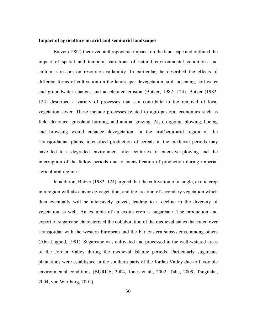
30
Impact of agriculture on arid and semi-arid landscapes
Butzer (1982) theorized anthropogenic impacts on the landscape and outlined the
impact of spatial and temporal variations of natural environmental conditions and
cultural stressors on resource availability. In particular, he described the effects of
different forms of cultivation on the landscape: devegetation, soil loosening, soil-water
and groundwater changes and accelerated erosion (Butzer, 1982: 124). Butzer (1982:
124) described a variety of processes that can contribute to the removal of local
vegetation cover. These include processes related to agro-pastoral economies such as
field clearance, grassland burning, and animal grazing. Also, digging, plowing, hoeing
and browsing would enhance devegetation. In the arid/semi-arid region of the
Transjordanian plains, intensified production of cereals in the medieval periods may
have led to a degraded environment after centuries of extensive plowing and the
interruption of the fallow periods due to intensification of production during imperial
agricultural regimes.
In addition, Butzer (1982: 124) argued that the cultivation of a single, exotic crop
in a region will also favor de-vegetation, and the creation of secondary vegetation which
then eventually will be intensively grazed, leading to a decline in the diversity of
vegetation as well. An example of an exotic crop is sugarcane. The production and
export of sugarcane characterized the collaboration of the medieval states that ruled over
Transjordan with the western European and the Far Eastern subsystems, among others
(Abu-Lughod, 1991). Sugarcane was cultivated and processed in the well-watered areas
of the Jordan Valley during the medieval Islamic periods. Particularly sugarcane
plantations were established in the southern parts of the Jordan Valley due to favorable
environmental conditions (BURKE, 2004, Jones et al., 2002, Taha, 2009, Tsugitaka,
2004, von Wartburg, 2001).

31
Industrialization and intensification of agriculture during the Mamluk period in
Jordan must have affected small-scale communities and potentially their local
environments because of state agricultural investment in the production of the exotic
crop (Laparidou and Rosen, 2015). Intensive cultivation leads to soil loosening by
breaking the sod while disturbing the rooting network. The ability of the soil to absorb
water decreases and soil becomes highly susceptible to erosion (Butzer, 1982: 125).
Centuries of extensive plowing would also lead to enhanced erosional events, and soil
impoverishment through the eventual leaching of clays and organic matter (Butzer,
1982). Geoarchaeological investigations of a Late Holocene fill in the Wadi ash-
Shallalah, on the Irbid Plateau report on the development of an A/C horizon and the
accumulation of a colluvial deposit (Unit VII) that contains sherds which date to the
Hellenistic, Roman and Byzantine periods, indicating that agricultural intensification on
the plateau led to the destabalization of the slopes and to erosion (Cordova, 2008). Also,
geoarchaeological investigations of the silt beds of the Madaba-Dhiban plateau based on
recorded high-magnetic susceptibility values, indicated that periods of intense erosional
events occurred due to land-use intensification sometime after the Early Islamic times
(ca. 636-1174 AD) (Cordova, 2000). The loss of as low as 20% of fertile top soil, can
dramatically decrease crop yields (Butzer, 1982).
Furthermore, large-scale production of grains on the central plains of Madaba in
Jordan). This is a region where some of the most profitable fields were located (iqta'at)
took place during the Mamluk rule (mid-13th century) (Walker, 2004). Land under
imperial cultivation was managed by a local official who was responsible for building
canals, irrigation ditches and dams for water management and profitable exploitation of
the land (Walker, 2011). Building activities related to cultivation can have great effects
on local landscape and ecologies if they are not maintained properly or are abandoned.

32
For example, building activities refer to field terraces on hills and slopes, which during
post-abandonment phases can enhance erosion (Butzer, 1982: 127). Similarly, irrigation
ditches can enhance erosion when abandoned, dams also would lead to flooding events
and the destruction of crop fields, threatening safety of livestock and humans (Butzer,
1982). Additionally, during periods of drought, in the semi-arid areas of Transjordan,
both soil loosening and devegetation would lead to slope erosion and reduced percolation
of rainwater into the subsoil, and hence the lowering of the groundwater table, reducing
spring discharge and water supply to streams (Butzer, 1984: 126).
In the Mediterranean Basin and Levantine agricultural systems, crop-rotation
regimes traditionally are employed for retaining moisture and soil fertility (Butzer, 1996,
Halstead, 1990, Palmer, 1998, Palmer, 2002). Mediterranean traditional agro-pastoral
systems have been proven sustainable in the long-run (Butzer et al., 1985, Butzer, 1999).
In his review article on the Mediterranean agrosystem, Butzer (1996) emphasizes in his
concluding remarks that agrosystems of the region evolved through trial and error and
have been proven sustainable throughout a long history of destruction and restoration.
Tillage, weeding, bare-fallow, and crop-rotation systems are agricultural strategies that
farmers employ to ensure sufficient nitrogen levels, as well as restoration of soil
moisture and fertility in the soil (Palmer, 2002).
THEORETICAL AND ETHNOGRAPHIC MODELS OF RISK BUFFERING AGRICULTURAL
PRACTICES IN THE EASTERN MEDITERRANEAN REGION
Much ethnographic and ethnobotanical work investigated agricultural risk-
buffering strategies and social organization of farming communities in the Eastern
Mediterranean region (Halstead and Jones, 1989, Halstead, 1990, Palmer, 2002, Palme,r
1998). Halstead and O'Shea (1989) suggest that farming communities employ a variety
of agricultural risk-buffering strategies that can be employed to cope with potential crop

33
failure due to natural and cultural hazards. These strategies include diversification,
mobility, storage, trade and exchange (Halstead and O'Shea, 1989). Halstead and Jones
(1989) described various agricultural practices of Greek peasant societies of the Aegean
and summarized the measures that peasants used traditionally in order to cope with crop
failure. In his model peasants have the choice to shift between intensive/traditional
agriculture that does not require large labor input and minimize risk, and alternatively
intensive agriculture that requires greater labor input but offers greater security due to the
production of surplus. The variety of cultural mechanisms that they analyzed could be
summarized briefly as follows:
a) Peasants could employ low-level mechanisms against crop failure and food
shortage, such as diversification of production. For example, an emphasis on barley
cultivation as opposed to wheat could indicate a buffering economic strategy against
uncertainty and drought conditions, as barley is a more drought resistant crop than wheat,
b) They could rely on dispersed fields, c) grow a range of crops, and d) rely on
intercropping and livestock which serves as a repository of grain surplus. O'Shea (1989)
also argues that reliance on livestock and large domestic animals could provide a cushion
for small-scale societies of agriculturalists during bad years of rainfall and environmental
turmoil. They also rely on the production and storage of a normal surplus of agricultural
products and by-products (Halstead and Jones, 1989).
Also, during their ethnographic research conducted in Greece, Halstead and Jones
(1989) showed that even in time of extreme risk of food shortage peasant communities
adapted to crises and did not migrate. They reclassified crops that were used as animal
fodder as human food during bad years. In order to cope with extreme natural and
cultural crises, peasant communities invest in direct storage of grain-surplus, depend on
exchange systems and, as a last resort, they abandon their villages (Halstead and Jones

34
1989). During bad years bread was made from barley, animal fodder was used for human
consumption and bitter vetch, during World War II in Greece, was eaten as a famine
food (Halstead and Jones 1989).
Annual environmental shifts in precipitation impact small-scale farming
communities in arid/semi-arid regions that depend on adequate annual rainfall and soil
productivity for successful annual crop-yields (Butzer, 1982, Halstead, 1990, Rosen,
2007). Butzer (1982: 9) argued that spatial and temporal variability of rainfall has a
significant impact on historical processes such as demographic pressure, trade resources,
depopulation, internal migration and a shift from cash crop economy to a subsistence
base economy. The flexibility in agricultural practice depends on the complexity of day-
to-day decision-making in a farmer's day, while farmers' adjust the schedule of family
tasks. Year-to-year decision making is affected by variations in weather conditions
(Halstead and Jones, 1989).
In the Mediterranean Basin, environmental systems are related to seasonality and
the rotation of winter rainfall and summer droughts. During his ethnographic research in
Greece, Halstead (1990) showed that farmers are heavily affected by a variety of natural
and cultural hazards in the semi-arid southern and eastern regions of the country.
Drought is the major reason for crop failure, and frost and dry winds destroy harvests
almost every year, across different regions of Greece, and the frequency of drought years
or frosts and dry winds will greatly affect the capacity of farmers to produce and store
normal surplus (Halstead, 1990).
Palmer (1998) argues that in northern Jordan, although it is a region characterized
of a Mediterranean climate, the majority of the area lies in the semi-arid zone. Average
annual rainfall is 550 mm around the city of Irbid, 221 mm 15 km east of Irbid, while the
probability of receiving below 300 mm is 21% and one year in five years the wheat crop

35
will fail. Jordanian farmers deal with ground frosts in the winter, while summer is a
stable season for agriculture in northern Jordan (Palmer, 1998). Variation in local
temperature is typical of Mediterranean and semi-arid climates and would affect annual
and inter-annual crop harvest.
In medieval Islamic Jordan, local topographic settings framed the social
transformations during the Middle and Late Islamic periods. Communities in the well-
watered areas in the Northern part of Jordan did not abandon full-time settlement at the
end of the 14th
century (Walker 2 003, Walker, 2005), while communities in the arid and
semi-arid regions of the Jordanian plains and southern parts of Jordan were more
dependent on rain-fed agriculture. As such, communities and the peasants of southern
and central Jordan were at higher risk of food shortage in the absence of state support
(Walker 2004, Walker, 2007, Walker, 2012).
Risk buffering agricultural practices from Jordan
Jordan is an environmentally diverse region which should have offered different
opportunities for state agricultural investment during the medieval Islamic periods but
also unequal opportunities to peasant communities for resource exploitation and
adaptation.
During her ethnographic research in southern and northern Jordan, Palmer (2002)
showed that farmers relied heavily on storage of a range of crops and crop by-products.
The Jordanian farmhouse had bins for storing grain, called kuwara, as well as
underground storage cisterns. Also, according to oral traditions, farmers and Bedouins of
Jordan, relied on the consumption of wild plants and barley during bad years which
could provide grain for the preparation of flour and household meals in the more arid
areas of the country. Although wheat is the main grain used for the preparation of flour

36
and the main dishes of the Jordanian family, historically barley was eaten and was not
grown only for fodder.
Palmer (2002) observed that preparation of grain, as well as milk products for
long-term storage formed the basis for subsistence for villagers in the north, as well as
the southern areas of her study. The villagers depended on the availability of privately
owned grain mills around the village and the long-term storage of whole and crushed
grains. Dough-ripe grains suitable for long-term storage were used for the production of
roasted wheat called Frika. Also, they relied on parched grain flour which has a longer
storage life (Galiyya), and on whole grains which were used to produce burghul, a basic
staple. Also, Palmer (2002) wrote that farmers from southern Jordan relied on storable
milk products such as yoghurt (ghabib), butter (zubda), defatted yoghurt (laban) or
strained laban (jamid).
Overall, Jordanian farmers depended on a mixed agro-pastoral economy and
employed diversification, namely a variety of crops produced and livestock kept.
Diversification is used as a low-level mechanism against crop failure and food shortage
(Palmer 1998, Palmer, 2002). Most of the everyday traditional meals are based on grain
and milk products, which when mixed provide the basic elements of the local economies
of the northern Hawran region and southern Jordan.
Livestock would provide the farmers with animal dung which has an important
role in the household economy (Valamoti and Charles, 2005, Palmer, 2002, Palmer,
1996). Animal dung, particularly cattle, sheep, or goat dung, would be used as fuel for
fireplaces as well as the ash fuel used in the domestic ovens, called tabuns. The animal
dung was actually necessary in order to maintain a tabun. A bed of dung ash was placed
around the tabun sloping slides and over the lid which covers it (Palmer, 1996, Palmer,
2002). Milk products would provide a buffer for the Jordanian family in the north where

37
rain fed agriculture is practiced, as well as the south, where milk products were even
more highly rated. The farming community depended heavily on fodder availability in
order to maintain the livestock, and during poor rainfall years milk quality and yield
would be too low (Palmer, 2002). Thus, the abundance of fodder as well as grazing was
critical for the farmers.
Fodder is a valuable commodity among farming communities in Jordan and is
stored in pens, caves and special buildings for fodder storage called tibban (Palmer,
1998, Palmer, 1996, Van der Veen, 1999). During bad years of low rainfall and crop
failure the Jordanian family consumes barley, a drought resistant crop, which was
previously used as fodder in good years (Palmer, 1998). Primarily, fodder includes wheat
chaff and straw, barley, bitter vetch and lentil. Fodder crops also include common vetch,
straw from all legumes and horse bean, as well as wild grass, which is collected, dried
and stored in the villages. In northern Jordan, spring lush ground vegetation is available
for grazing livestock. Goats graze year round on trees; in the summer they graze on
stubble, while in the spring the animals were taken to the Jordan Valley (Palmer, 1998).
During the Mamluk period in Transjordan, grains were the basic staple and cash
crops, but cereal grains were managed by the state as the main cash crops. Grains formed
the basis of the Mamluk economy (Walker, 2009).
Walker (2008, Walker, 2009) pointed out that grain storage in Mamluk Jordan
also had taken two forms: formally built shunas and reused cisterns. Grains would be
transported from the threshing floors to the storage facilities over the land using the main
road systems. During the Mamluk hegemony in the 14th century, grain storage facilities
were in use all over Jordan and grain was stored on-site and at transport routes (Walker
2008, Walker, 2009). Grain surplus would be used for times of need by the state through

38
forced purchases, or to be given to agricultural laborers who worked on sugar estates
(Walker 2008, Walker, 2009).
Crop rotation regimes and crop-processing in Jordan
Palmer (1998) described the agricultural practices of northern Jordan. According
to Palmer (1998), although land tenure has changed from the musha system of
communally owned land to private shares of households, over the last 100 years in
Jordan the agricultural cycle remains essentially the same. In the Jordan Valley during
the Mamluk periods, land not assigned as iqta'at, may have been communal, and
revenues were shared among villagers after harvest (musha system) (Walker 2008,
Walker, 2009).
The agricultural year for arable crops begins with the first winter rains, when
wheat is planted in order to be harvested in the summer. Crops planted in the rainy
season are called winter crops and crops planted after the rainy season are called summer
crops (Table 1.1). Today in northern and southern Jordan, free-threshing Durum wheat
(Triticum durum) and two-row barley (Hordeum sativum L.) are the main winter cereal
crops planted (Palmer 1998, 2002). Six-row barley (H. vulgare) was also introduced to
Jordan (Palmer, 1998).
Crop rotation regimes in northern Jordan today include a two-year rotation and a
three-course rotation regime (Palmer, 1998). In the two-year rotation system a cereal is
planted, and summer crops are planted during the fallow year on the same plot. The three
year rotation describes cereal, legumes and fallow years. Cereal crop and other winter
crops are harvested in May. For better quality of straw, farmers use hand harvesting
methods and they cut the straw low to the ground. Cereal straw is a valuable crop by-
product today in Jordan and prices have increased due to the import of wheat grain.

39
Summer crops are harvested after June and July until September (Palmer, 1996, Palmer,
1998).
Table 2.1 Common winter and summer crops cultivated in northern Jordan (After Palmer
1998)
Crop Botanical name
Wheat (durum) Triticum durum Desf
Barley (hulled 2-row & 6-row) Hordeum sativum L.
Lentil Lens culinaris Medik.
Bitter vetch Vicia ervilia (L.) Willd.
Horse bean Vicia faba L.
Grass pea Lathyrus sativus L.
Common vetch Vicia sativa L. subsp. sative
Fenugreek Trigonella foenum-graecum L.
Barley is planted first, prior to wheat and traditionally both cereals are sown and
tilled by men. The optimum time to plant is during November, in more recent years
winter rain starts in December (Palmer,, 1998). Tillage is very important for retaining
moisture and soil fertility in the Jordanian agricultural system, as well as crop rotation.
Tillage takes place twice a year. Firstly, it takes place between July and November,
afterwards fields remain un-worked, and after March fields are tilled four times (Palmer
1998). Legumes (horse bean, bitter vetch, and lentil) are planted after cereals. Traditional
crop-rotation is used to ensure sufficient nitrogen levels in the soils. Also, bare-fallow
(land left unplanted) success depends on tillage, and bare-fallow would assure the
restoration of soil moisture and fertility. Short fallow (land sown with summer crops)
includes the sowing of summer crops during spring tillage and will improve land quality

40
in the long-run. Weed control is also important for retaining soil moisture, and in
northern Jordan is assured by fallow and crop-rotation. Hand-weeding is also practiced in
Jordan and the Mediterranean region between January and March (Halstead and Jones,
1989). Certain agricultural weeds however are collected and used as fodder as well
(Palmer, 1998). In the Mamluk period the iqta' system was evaluated largely on the basis
of grain yields, and was administered by local personnel the local muqta'. The muqta'
was responsible for tax assessments and collection and supervising the crop rotation
(Walker, 2011).
Crop-processing stages in the Aegean region and Turkey include threshing,
winnowing and sieving (Hillman, 1984, Hillman, 1981, Jones, 1984). In northern Jordan,
free-threshing wheat, legumes and barley crops are left to dry and heaped on the
threshing floor. During threshing, grain is released from chaff, and seeds from legume
pods using a threshing sledge. Afterwards, winnowing separates light straw, chaff and
weed. Light chaff is bagged for fodder and the heavier components are coarse-sieved.
During coarse-sieving, the coarse chaff is separated from grain and the former is bagged
for fodder while good quality straw is kept to be used in basketwork (Palmer, 1998).
Fine-sieving is then conducted away from the threshing floor, usually at home.
Manuring and soil fertilizers
For Jordanian farmers, animal dung is the most productive soil fertilizer which
can improve crop yields up to ten years. Palmer (1998) during her ethnographic study in
northern Jordan observed that animal dung became rarer and chemical fertilizers have
been introduced, but these only improve yields for one year. Animal dung was added to
the agricultural fields while animals graze on stubble or animal dung was transferred
from pens to the fields and spread during the spring tillage period (Palmer 1998).

41
ARCHAEOBOTANICAL AND ETHNO-BOTANICAL STUDIES AND PHYTOLITHS ANALYSIS
Hillman (1981) conducted ethnographic work in Turkey (both on free-threshing
and glume wheat), and Jones (1984) on the Greek island of Amorgos (on free-threshing
cereals and pulses) in order to explore the impact of crop-processing on archaeobotanical
sample composition. They recorded the full sequence of husbandry and processing
methods applied to different crops, and the crop product and by-product during every
processing sequence from threshing onwards (Hillman 1984, Jones 1984).
According to their conclusions, crop-processing stages can determine the
proportions of cereal grain, cereal chaff and weed seeds in an archaeobotanical sample
and suggest whether crop production was local, judged by early processing stages by-
products. I use their conclusions in order to explore whether the sites under study in this
dissertation produced their own crops, intensified agriculture via diversification or
irrigation, and whether cereal production was primary economic activity of the medieval
settlements during the period between the 13th and 15th in Transjordan.
The presence of early-stage crop-processing by-products would imply cultivation
within the region of small-scale agricultural societies (Harvey and Fuller 2005, Van
derVeen 1999). Depending on the cereal species cultivated, cereal husks can be
considered as early or late stage by-products. If free-threshing wheat was cultivated the
husks and straw are considered as an early stage by-products from threshing. If hulled
barley was the dominant species, the husk would have stayed on the grain if used for
fodder, and it would have not necessarily been removed. Wild-weed grass husks could be
an early stage by-product depending on crop-processing procedures, such as
sieving/crop-cleaning. As a dung indicator, it doesn't necessarily reflect an early stage
by-product as the animals could have been grazing the whole plant. Cereal straw could
be an indicator of local agricultural production and is interpreted as an early-stage by-

42
product. It also has an intrinsic economic value as it is used as fodder for animals as well
as a building material.
Crop-processing by-products are used as fodder and can be used in
archaeobotany and archaeology to identify animal dung fuel. Ethnographic and
archaeobotanical studies have been employed to identify an economic value of fodder
and animal dung as fuel, for settlers of dry regions (Charles et al., 1998, Charles and
Hoppé, 2003, Valamoti and Charles, 2005, Charles, 1996, Van der Veen, 1999,
Valamoti, 2007, Miller, 1984, Hillman et al., 1997). During his ethnographic research
conducted in the semi-arid region of southern Iraq Charles (2010) investigated animal
and crop husbandry regimes and the impact of animal dung fuel on the archaeobotanical
material composition. During the 1980 study period, fodder was scarce. Animals grazed
on the stubble of barley fields in early spring, while agricultural weeds and wild plants
were also collected and fed to the animals (Charles et al., 2010). Farming communities
manufactured dung cakes used as fuel for bread ovens or as manure. Residues of dung
used as fuel contained grazed material, crop-processing residues and wild plant material
used as fodder (Charles et al., 2010). Valamoti and Charles (2005) showed that glume
wheat spikelets behave differently. They appear in dung in the form of fragments, while
spikelets from hulled barley grain can occur intact. Alternatively, their experiment
showed that the grain of some cereal species may not survive digestion in a recognizable
form, indicating the importance of taphonomic factors that need to be considered in order
to indentify animal dung. Valamoti and Charles (2005) argue that glume wheat chaff in
dung deposits derived from glume wheat ears fed to animals, either as a whole spikelets
or broken up spikelets, or as crop processing by-products.
Phytoliths can be identified and used as indicators for the presence of animal
dung (Albert et al., 2008, Madella, 2003, Lancelotti and Madella, 2012, Portillo and

43
Albert, 2011, Shahack-Gross, 2011, Tsartsidou et al., 2008). I use correlation coefficient
graphs of weeds vs. straw, husk (wheat and barley) vs. straw and husk vs. weeds in order
to indicate assemblages derived from hearths and tabuns. They indicate the presence of
animal dung used as fuel. Lower frequencies of cereal husk phytoliths and higher
frequencies of stem and leaf phytoliths could indicate goat dung remains (Madella,
2003).
Harvey and Fuller (2005) applied crop-processing models from macro-botanical
assemblages, to the analysis of archaeological rice and millet phytolith remains derived
from Neolithic sites in India. They argued that the study of phytolith assemblages as
indicators of crop-processing could shed light on the socially organized labor and
production of food.
The early Islamic world contributed to the medieval global markets through the
cultivation and distribution of new major cash and staple crops for local production and
international markets (Abu-Lughod, 1991, Watson, 1983). Agriculture was intensified
during periods of increased production of cash crops such as sugar, cotton, and rice but
also with the rise in varieties of crops and diversification of production (Morrison, 1994).
The Political Economy of the medieval states increased the demand for the production of
cash crops for the state, and impacted subsistence production in the region of
Transjordan (Decker, 2009).
The region of the Near East is a mosaic of an ecological and climatic diversity
and offers an excellent opportunity of environmental research to relate both issues: the
political control of resources in middle and late Islamic Jordan and its impacts on
agricultural practices. Periods of environmental change along with the increasing interest
of global scale distribution of cash crops would have affected the viability of medieval
states as well as the well-being of the peasants. The next Chapter describes literature on

44
the effect of climate change and anthropogenic-economic factors in the Southern Levant
during the Late Holocene.

45
Chapter 3: Late Holocene environments in the Southern Levant
(2000 BC to present)
The environmental and climatic history of the Pleistocene and the Holocene in
Southern Levant is recorded in a variety of proxy data, such as pollen and stable isotopes
from the Mediterranean Sea, lakes, speleothemes, tree rings, geoarchives,
archaeobotanical and other bioarchaeological data (Cordova, 2007, Rosen, 2007). Their
analysis contributes to the study of the climatic history of the Near East throughout the
Holocene and is of interest to environmental scientists, archaeologists, and historians.
The Holocene in the Levant is marked by an overall trend towards increased
aridity in the region. Based on palaeo-climatic records, it is apparent that the Early and
Middle Holocene climatic conditions were wetter than the Late Holocene and present
day conditions in the Southern and Northern Levant. Overall δ18
O values from Soreq
Cave and Peqiin Cave in Israel increased throughout the Holocene indicating a trend
towards decreased rainfall and warmer temperatures (Bar-Matthews et al., 2003,
Migowski et al., 2006, Rambeau and Black, 2011, Bar-Matthews et al., 1997). Also,
estimates of palaeorainfall amounts at the Soreq Cave indicated decreasing rainfall from
7200 yr BP and this data showed that rainfall never reached the Early Holocene rainfall
amounts again (Bar-Matthews et al., 2003). A radical drop of the carbon isotopic values
from the Soreq Cave speleothemes from 7200 to 7000 yr BP indicated a radical drop of
rainfall that was followed by a general trend towards decreased rainfall (Bar-Matthews et
al., 1999). The average values of the δ18
O data from Soreq Cave were higher between
4000 yr BP and the present day, and lower between 4000 to 7000 yr BP (Bar-Matthews
and Ayalon, 2004).
46
Figure 3.1, δ18
O and δ13
C data from Soreq Cave (After Bar-Mathews et al. 2004)
However, following a cooling and low rainfall event that took place at ca. 7000
yrs BP the climate was highly variable in the eastern Mediterranean during the
Chalcolithic period (6500 - 5800 yr BP) and the Early Bronze Age (5800 - 4000 yr BP)
(Figure 3.1). According to the δ18
O and δ13
C values from Soreq cave speleothemes the
region was experiencing frequent wet events. Figure 3.1 indicates that from 7000 yr BP
-6.5
-6
-5.5
-5
-4.5
-4
0
0.3
5
0.5
0.6
7
0.7
0.7
5
0.8
5
1.1
1.4
1.5
5
2
2.4
2.6
3
3.2
3.4
3.5
5
3.6
2
3.8
3.9
3.9
2
4.1
4.3
4.5
4.7
4.9
5.0
5
5.1
5.2
2
5.4
5.6
5.8
6.2
6.4
6.7
6.9
Age (kyr) BP δ18O
-13
-12.5
-12
-11.5
-11
-10.5
-10
-9.5
-9
-8.5
-8
0
0.3
1
0.6
4
0.8
2
0.9
2
1.2
5
1.6
2.2
2.6
3.2
3.5
3.6
2
3.8
3.9
2
3.9
8
4.0
5
4.1
4.2
2
4.3
9
4.5
4.6
1
-4.9
4.9
7
5.0
5
5.1
2
5.2
5.2
9
5.4
5.9
6.2
6.7
7
Age (kyr) BP δ13C

47
to 2500 yr BP periods, small but frequent fluctuations in humidity and climatic variation
took place (Rambeau and Black, 2011, Bar-Matthews et al., 2003, Bar-Matthews and
Ayalon, 2004). Also, the lower δ18
O values of the planktonic foraminifera G. ruber
recorded at ca. 3200 yr BP indicate a very wet period (Schilman et al., 2001).
Aridification processes became prominent after the Early Bronze Age II and III (5000 to
4400 BP) (Goldberg and Bar-Yosef, 1982, Bar-Matthews et al., 1999) (Figure 3.1).
Orbital changes that weakened monsoonal activity after ca. 7000 yr BP are among the
factors that led to the onset of this aridification process.
A plethora of new studies of direct and indirect proxies from the Levantine Basin
and Southern Levant provide a higher resolution of climatic variability throughout the
Holocene than previously feasible particularly, isotopic records of marine foraminifera
and cave speleothemes which are ideal proxies for palaeoclimatic reconstruction. The
scale of climatic fluctuations throughout the Holocene had a wide range of variations
(Rosen, 2007, Bar-Matthews et al., 1998, Bar-Matthews et al., 1997). These new studies
indicate that Holocene short-term climatic shifts took place in the Eastern Mediterranean
that had significant environmental, societal, and political implications (Rosen, 1995,
Rosen, 2007, Rambeau and Black, 2011, Finné et al., 2011).
The Late Holocene, which is the period of interest for this thesis, is associated
with a long period of urban expansion, periods of agricultural intensification, and
technological advancements that followed the establishment of great Empires in the
Southern Levant, such as the Roman and Byzantine Empires, as well as the eras of the
medieval states and the Ottoman Empire. Due to sociopolitical and economic
advancements associated with the rise of these Empires, the impact of climatic variability
on the society and the environment, and the degree to which cultural shifts and
ecological impacts depended on the climate is more complex (Rosen 2007).

48
Table 3.1 The Holocene timeline (after Rosen 2007)
Early Holocene Middle Holocene Late Holocene
9500-5500 cal. BC 5500-2000 cal. BC 2000 cal. BC-present
Unfortunately, climate trends during the Late Holocene and particularly the
medieval period still are poorly understood. The problem is that reconstructing palaeo-
climates during the Late Holocene demands precision on relatively short time scales, but
currently lacks robust geoarchives and more high-resolution palaeoclimate records for
regions such as the Levant, Greece and Egypt (Finné et al., 2011, Haldon et al., 2014).
Historical sources become useful after about 1200 AD north of the Alps, which doesn't
add much information in the Mediterranean world (Büntgen and Tegel, 2011). High
flood recurrences, with a very incomplete record in Iberia are particularly relevant
(Moreno et al., 2012) as is the situation in Cyprus (Butzer and Harris, 2007). The
advances and retreats of the Alpine glaciers are known in a general way, and are helpful,
but we still know too little about the Medieval warm Period (MWP) about 1100 to 1500
AD.
In this chapter, I am presenting a summary of relevant palaeo-environmental
records from the Southern Levant that indicate the general climatic trends which were
established in the region during and after the transition from the Middle to the Late
Holocene periods. . In the Mediterranean Basin, environmental systems are related to
seasonality and the rotation of winter rainfall and summer droughts. Jordan has a climate
that ranges from Mediterranean to arid and receives only one rainy season a year in the
fall, a very busy time when farmers prepare the land for sowing, and harvest. However,
fluctuations of annual rainfall are often. Variation in local temperature is typical of

49
Mediterranean and semi-arid climates and would affect annual and inter-annual crop
harvest.
In the medieval times, pollen evidence indicate that cereal cultivation became
crucial to the Early medieval states and to the society. Relatively humid conditions
prevailed at the end of the Crusader period and the beginning of the Mamluk period.
Lake level rose to a high stand and humid events occurred between circa 1100 AD circa
1200 AD. However, periods of increased rainfall and moister conditions were periodic
throughout the Mamluk period, and overall low Dead Sea levels were recorded in the
environmental records, indicating cooler and dried conditions.
The establishment of the Mamluk rule in the Transjordan corresponds with a
radical drop in lake level, at around circa 1300 AD but that overall Lake levels did rise
throughout the Mamluk period after 1300 AD. Prolonged periods of annual rainfall
below 450-550 mm yr_1
would lead to periods of droughts.
Therefore, in the Early stages of the Mamluk state, agricultural investment and
expansion of agriculture in even marginal areas for crop-production - was accompanied
by favorable climatic conditions. However, later on the Mamluk state would have faced
droughts and would have had to adjust to unpredictable climatic conditions, and intensify
agriculture to ensure the production of agricultural surplus. I provided evidence for the
intensified production of agricultural crops and surplus for the state. Also, in this
dissertation I show that Peasants well adapted to climatic fluctuations in a semi arid area-
testing risk averse strategies.

50
LATE HOLOCENE PALAEO-CLIMATES IN TRANSJORDAN (2000 BC TO PRESENT)
Isotope Data
Bar-Matthews et al. (1997)' s, oxygen isotopic records from speleothemes from
Soreq Cave in Israel provide a history of changes in the rainfall rate from circa 25,000 yr
BP to circa 1,000 yr BP. δ18
O data from the cave deposits that date from 7,000 yr BP to
1,000 yr BP suggests that warmer and drier conditions occurred in the Late Holocene, as
compared to the Early and Middle Holocene. In particular, the δ18
O values for the period
of the Late Holocene indicate that rainfall conditions became similar to the present day
and rainfall amounts varied between 350-580mm in the eastern Mediterranean. Overall,
δ18
O–δ13
C trends indicate low frequency climatic variability during the Late Holocene.
Bar-Matthews et al. (2003), presented isotopic records from Soreq Cave, Peqiin
Cave, and a δ18
O marine record of the plangtonic foraminifera G. ruber for the last 7000
yr BP, comparing the continental palaeo-climatic record and the palaeo-oceanographic
record. They showed that there is a direct relationship between rainfall amount variations
and change in the δ18
O values from the speleothemes in caves in Israel. Overall, δ18
O
values increased throughout the Holocene, indicating a trend towards decreased rainfall
and warmer temperatures. Palaeo-rainfall data showed that after the end of the Byzantine
period at ca. 1300 yr BP, a period of overall arid conditions followed and annual rainfall
was lower than the present day average (Bar-Matthews et al., 2003, Bar-Matthews et al.,
1998). Average palaeo-rainfall values remained low but overall stable, in the post-
Byzantine periods, and increased after ca. 200 yr BP (Bar-Matthews et al. 2003) (Figure
3.2).
However, annual rainfall variations could be frequent in the region of Israel.
Rosen (2007) presents modern rainfall data from the region of Israel, of a twenty eight
year period when actual annual rainfall dropped below 400mm almost half of the

51
observed period. More interestingly, rainfall levels dropped below 300 and 200mm quiet
often. While a period of twenty-eight years might seem insignificant for long term
climatic changes, such variations could have dramatic effects on the production and
subsistence or market related agricultural production. Willcox reasonably argues that a
secure way of assuring dry farm agriculture in semi-arid regions like Israel and Jordan all
year round, is an excess of the 200mm and 250mm rainfall that barley and wheat need,
respectively (Willcox, 2005). Over 400mm would be regarded as secure for the
production of the cereals by inhabitants of agricultural subsistence sites. Otherwise,
people should buffer themselves with alternative strategies for secure food supply.
However, as modern data suggest average annual rainfall of 400mm is not always the
case. Thus, it is possible that during the period of the Late Holocene, risk buffering
strategies may have been adopted like intensification of production via irrigation, a shift
to drought resistant crops and the cultivation of more crops (diversification of
production).
Figure 3.2 Calculated paleorainfall average values at the Soreq Cave site
0
100
200
300
400
500
600
700
800
0
0.2
1.8
2.1
2.4
2.6
3
4
4.8
5.2
5.8
6.2
6.8
6.8
6.8
5
7
7.5
Age (ky) BP
Palaeo Annual Rainfall

52
Figure 3.3 Paleo Sea Surface Temperature. The horizontal bar indicates the present-day
values in Soreq Cave area. (After Bar-Mathews et al. 2003).
Dubowski et al. (2003), analyzed three cores taken from Lake Kinneret for the
organic carbonate content and its isotopic composition, and organic N content in order to
reconstruct regional climatic conditions during the Late Holocene in the Southern
Levant. According to their study of modern sediments, lower carbonate content and
depleted isotopic composition indicate wet periods of frequent floods. Also, they
discovered that the C:N ratios increase, during periods of wet, moist events. They
concluded that between 300 BC and 350 AD, climatic conditions were humid and lake
productivity levels increased. These periods were marked by a very high population
density in the region during the establishment of great Empires in Southern Levant,
including the Greek and Roman and according to pollen studies, the vegetation that
indicates agricultural productivity expanded in response to climatic amelioration and
agricultural innovation (Neumann et al., 2010, Neumann et al., 2007, Baruch, 1990). The
Early Islamic periods (700 - 1050 AD) are characterized by drier conditions, a fact that is
reflected in high values of the δ18
O–δ13
C isotopic record. Drier climatic conditions would
0
5
10
15
20
25
30
0
0.2
0.5
1.8
2
2.4
2.6
2.8
3
3.2
3.8
4.8
5.2
5.6
6.2
6.6
6.8
6.8
5
7
7.2
Age (ky) BP
Palaeo SST values

53
have negatively impacted agricultural activities a fact that is also represented on pollen
records from the regions. The latter, suggest forest regeneration and low representation
of agricultural crops at the beginning of the Arab Periods (Baruch, 1990, Neumann et al.,
2010, Neumann et al., 2007, Baruch, 1986). Low δ13
C values during the beginning of
stage D, which corresponds to the Middle/Late Islamic periods (1050-1518 AD), suggest
that a short wet episode occurred in 1150 AD but was followed by cooler, but drier
conditions, similar to Stage C of core KINU8 (1150-1780 AD) (Dubowski et al., 2003).
Another isotopic record derives from two marine cores in the region of the SE
Mediterranean, off the coast of Israel, and covers the last 3.6 ky BP (Schilman et al.,
2001). Schilman et al. (2001), also showed that brief humid events occurred in the
Middle Holocene, followed by more arid conditions in the Late Holocene. They
measured the δ18
O–δ13
C values of the planktonic foraminifera G. ruber and the δ13
C
values of the foraminifer U. Mediterranea that derived from the two marine cores and
showed that during the Late Bronze Age period at ca. 3600-3000 yr BP moist conditions
prevailed based on decreased values of δ18
O of G. ruber (Figure 3.5). Between ca. 3000-
2000 yr BP higher values of δ18
O of G. ruber, indicated a period of more arid climatic
conditions (Figure 3.5). During the Late Holocene, between ca. 2000-1000 yr BP, higher
precipitation events took place, based on low values of δ18
O of G. ruber, also shown by
high Dead Sea lake levels and other isotopic records from the region (Frumkin et al.,
1999, Bar-Matthews et al., 1998). According to Schilman et al. (2001), throughout the
Late Holocene isotope records were not uniform and variability peaked during certain
periods. Higher δ18
O values recorded short periods of drought at ca. 50 BC and 1700
AD, while extreme humid events occurred during ca. 1250 BC and 550 AD based on
lower δ18
O values. Overall, Schilman et al. (2001) suggest that δ18
O of G. ruber values
gradually increased, from ca. 1300 yr BP to 900 yr BP, indicating drier conditions in the

54
post-Byzantine periods. Particularly, in the Early Islamic periods from ca. 650 to ca.
1050 yr BP, arid conditions prevailed based on increased values of δ18
O of G. ruber.
During the Middle and Late Islamic periods δ18
O of G. ruber values were more variable,
and climate marked a shift towards smaller fluctuations in humidity. A short humid event
was recorded at ca. 0.8 yr BP (1150 AD) but overall values increased until and a cool
and arid event at ca. 0.27 yr BP (1680 AD).
Also, Schilman et al. (2002), compared the marine isotopic record of δ18
O values
of the planktonic foraminifera G. ruber from the region of SE Mediterranean with the
isotopic record of carbonate cave deposits from Soreq cave (Figure 3.4 and 3.5) that
cover the climatic history in the last 3600 years. The striking similarities between the
terrestrial and marine isotopic records verify the reliability of these proxies as indicators
of regional palaeoclimatic conditions, and reflect the high resolution climatic variations
in the Late Holocene. Schilman et al. (2002), showed that humid conditions prevailed in
the Middle Holocene, between 3600-3100 yr BP (1650-1150 BC) followed by a shift to
drier conditions during 3100-2000 yr BP, and that a slighter shift to more humid
conditions took place in the beginning of the Late Holocene between 2000-1300 yr BP
(50 BC- 650 AD). An event of very humid conditions took place at ca. 1300 yr BP (650
AD) when the lowest δ18
O values were recorded. They recorded a shift to drier climate
between 1300-900 yr BP (650-1050 AD). After a short humid climatic event that must
have taken place between 900-600 yr BP (1050-1350 AD), increased values of the
isotopic record indicated the prevalence of drier and cooler conditions between ca. 600-
300 yr BP (1350-1650 AD). To sum up, the three lowest values of the marine δ18
O
isotopic record that indicated humid climatic events were recorded at ca. 3200 yr BP
(1250 BC), 1300 yr BP (650 AD), and at ca. 700 yr BP (1250 AD) and three events of

55
arid conditions at ca. 2100 yr BP (150 BC), at ca. 900 yr BP (1050 AD) and at ca. 300 yr
BP (1650 AD).
It is obvious that isotopic records of marine foraminifera are ideal proxies for
palaeoclimatic reconstruction. The δ18
O values reflect the temperature and humidity at
the time of deposition. Studies of the present day relationships between the isotopic
values and the parameters that affect these values showed that the primary ones are
evaporation/precipitation ratios and paleorainfall (Schilman et al., 2002). Schilman et al.
(2002), showed that the changes in the values of the isotopic record of Soreq Cave also
reflect the changes in the isotopic composition of the rainfall amount based on the fact
that Sea Surface Temperature and land temperature changed at an order of +/- 1 degrees
Celsius over the last 3600 years (Schilman et al. 2002). During later historic periods,
aridification seems to be increasing based on data of decreased Dead Sea levels towards
the Late medieval periods (Mamluk and Ottoman) (Isaar and Zohar, 2004). Carbon
isotope data analysis from the salt caves of Mount Sedom also indicated that dry
conditions governed the Early Islamic period (Isaar and Zohar, 2004, Frumkin et al.,
1991).

56
Figure 3.4 δ18
O record of Soreq Cave speleothem of the last 3600 years (after Bar-
Matthews et al., 2002).
Figure3.5 δ18O record of G. ruber (after Schilman et al., 2001c)
-6
-5.8
-5.6
-5.4
-5.2
-5
-4.8
-4.6
0
0.4
0.6
0.6
5
0.8
0.8
5
0.9
1.1
1.3
5
1.6
1.7
1.8
2
2.2
2.4
2.5
2.6
2.8
2.9
3.1
3.2
3.4
3.5
Age (ky) BP
δ18O
-1.2
-1
-0.8
-0.6
-0.4
-0.2
0
0.2
0.4
0.6
0.8
1
0 0.25 0.4 0.5 0.55 0.75 0.85 1.1 1.8 2.1 2.35 2.6 2.9 3.1 3.25 3.6
Age (ky) BP δ18O record of G. ruber

57
Late Holocene vegetation: the pollen evidence
Several pollen studies conducted at the western Dead Sea lake shore, lake cores
from Israel including Lake Hula and Lake Kinneret, and from the Golan heights, offer a
good history of anthropogenic influence on the regional environment and vegetation
change for the Late Holocene Transjordan (Baruch, 1986, Baruch et al., 1999, Leroy,
2010, Leroy et al., 2010, Schwab et al., 2004, Van Zeist and Bottema, 1982, Baruch,
1990). Oxygen and carbon isotopes from the Sea of Galilee compared to pollen data
indicated that over-exploitation of olives resulted in a neglected landscape of the region
during the Byzantine period (Isaar and Zohar, 2004: 24). Dendrochronological data from
Pinus nigra and Cyprus trees showed that moister climatic conditions occurred around
1500 AD, during the so called Little Ice Age, and returned to warmer conditions around
1700-1800 AD (Isaar and Zohar, 2004: 218). Whether this was the effect of climate
change or anthropogenic-economic factors is under question as major climatic shifts
have been proven to be of a regional scale (Bar Matthews, 1999).
Baruch, (1986), presented the results of pollen analysis conducted on core
KIN4D from Lake Kineret, in the North part of the central Jordan Valley, a
Mediterranean climate region. The pollen diagram is divided in six zones, Zone X1, X2,
Y, Z1, Z2 and Z3, based on changes of arboreal and non-arboreal pollen ratios. The
pollen diagram covers the vegetation history of the last 5300 years and four radiocarbon
dates are available; for Zone X1, 5250 +/- 520 yr BP, for Zone X2, 2955+/- 220 yr BP,
for Zone Y 2170 +/- 125 yr BP and for Zone Z1 1020 +/- 115 yr BP. The calibrated dates
available fix Zone X1 at circa 3300-1700 BC, Zone X2 at circa 1700 BC- 350 AD, Zone
Y at circa 350BC- 550 AD, and Zone Z1 at circa 550-1150 AD, Z2 at circa 1150-1750
and Z3 at circa 1750-1979 AD. Arboreal pollen percentages overall decrease towards the
top of the diagram. The main agricultural trend indicates the peak of olive cultivation at
58
around circa 1700 BC at the expense of oak forests at Zones Z1 and X2, and the gradual
decrease in olive percentages after that point. Near the top of Zone X2, higher values of
Plantago-lanceolata-type pollen increased, reflecting intensification of agricultural
activities during the transition from Middle to Late Bronze Age and Iron Age, of both
arboriculture and horticulture. The expansion of pollen of agricultural crops, including
olives, walnuts and grapes continues to be prominent in Zone Y (350BC - 550 AD) along
with increased values of Sarcopoterium spinosum-type indicating prominent
anthropogenic influence on the landscape. In Zone Z representing the post-Byzantine
period, the pollen of olives declines and forest regeneration is prominent. Although it
seems that olea diminishes in importance and agriculture deteriorates, graminae grass
pollen seems to increase at the middle of Zone Z1 up to the middle of Zone Z2, which
may indicate that the importance of cereal cultivation increased between circa 800-1450
AD.
Baruch (1990), compared the Late Holocene pollen diagram from Lake Kinerret
with two pollen diagrmans from the Dead Sea, one from near Ein Gedi and one from the
Sedom salina (Baruch, 1990). Both diagrams record the large-scale cultivation of olive in
the Roman-Byzantine period in Zones Y (top part) and 2a, respectively. The two Dead
Sea pollen diagrams also record the forest regeneration process, particularly an increase
in Pine pollen immediately after the end of the Byzantine period, a process that followed
the decline in overall land dedicated for olive groves at the Sedom region and an
immediate expansion of Quercus calliprinose forest. Quercus Boissieri expanded later
following a decrease of Pine forests, starting with the transition to the Arab periods, a
process that continued to take place until the modern era. In the Eid Gedi pollen diagram,
the transition to the end of the Byzantine period is followed by a general decline of the
olive type pollen, and an increase in Quercus Boissieri type pollen that declines in the

59
beginning of the Arab periods. The Early to Late Islamic periods are characterized by an
expansion of the Pine and Oak forests (Quercus Calliprinose type), but the overall low
values in the evergreen oak indicate an anthropogenic influence on the Mediterranean
vegetation. The increase in evergreen oak reflects less anthropogenic influence on the
Mediterranean vegetation of the Judean Mountain region. However, in both diagrams the
decrease in deciduous oak pollen-type around 1000 AD, indicate the destruction of the
natural forest, due to increased anthropogenic activities reflected on fluctuating intensity
of other values, such as the increase in Plantago lanceolata-type and Sarcopoterium
spinosum-type in the post Byzantine period.
Leroy (2010) presented pollen analyses of core DS7-1SC from Ein Gedi, that
provides the history of vegetation change over the last 2500 years in the Dead Sea region
in relation to precipitation changes and climatic changes. The trends of the pollen record
of the core DS7 reflect mostly land-use change and very few indications of climatic
oscillations for the Roman-Byzantine transition and for the transition to the Arab Periods
in the Transjordan. The transition to the Arab periods is marked by an abrupt change in
the agricultural pattern. Compared to the wealth investment in olives and grapes that
thrived in the Roman/Byzantine periods, in the Arab periods it seems it was neglected as
a major economic trend. In the Arab periods, the pollen record indicates that they do
agriculture but with an emphasis on agropastoral economy, and cereal cultuivation
peaked at 150 and 120-110 cm. That corroborates the general trend of interest in wheat
cultivation at a larger scale during the Mamluk Period and at a smaller scale, maybe in
small plots, until the Late Otoman Period. Also, the transition to the Arab Periods is
marked by an increrase in Pine and Oak forests of the Mediterranean vegetation. These
changes in agricultural trends took place under increasingly arid conditions from circa
the 7th century AD, as data for a low stand of the Ze'elim lake levels indicates.

60
According to the pollen diagram from Lake Hula in the Hula Basin, the Late
Holocene can be placed according to the corrected and interpolated dates near the bottom
of Zone 8 (2150 BC) (Baruch et al., 1999). Here, evidence shows extensive cultivation of
olives took place in the Northern Levant during the Roman/Byzantine period which
declined at circa 850 AD. During the Arab periods the pollen record form Hula also
points to a decrease in olive-type pollen and to a process of forest regeneration. During
the middle of Zone 10, which corresponds to the Middle/Late Islamic period transition, a
gradual increase in grasses could be indicating the intensified production of cereals in the
region of the Transjordan that also corresponds with a marked drop in Quercus
calliprinos-type pollen. The latter, increased overall in the Late Holocene.
Van Zeist et al.(2009) examined sediments from the Hula core (van Zeist et al.,
2009). Based on interpolated chronology in calendar years of the diagram their evidence
showed that the transition to the Arab periods from the Roman/Byzantine period, is
placed between Zone 7/8 and the top of the diagram. Although the overall percentage of
Poaceae indet.-type pollen decreased in the post Byzantine period from 35% to 5%, the
Poaceae indet.-type rose to a peak of 15-20% between 1200s-1300s AD, its highest value
in the entire Zone. Cerealia-type declined at the end of the Byzantine period and rose
again slightly in the early Arab period but rose again to a peak of 5% between 1200s-
1300s AD.
Another pollen diagram for the Late Holocene comes from a core from the crater
lake, Birkat Ram, in the Northern Golan heights. The pollen diagram after the age
correction for the reservoir effect, offers a vegetation history of the past 6500 calendar
years. The deforestation events recorded in this diagram took place at circa 4500 BC in
LPAZ 1 and 2, while olive cultivation was increasing. The expansion of the forest
renewed in the Bronze Age - Iron Age transitional period in LPAZ 2-3. Between the end

61
of Iron Age and end of Byzantine period, the pollen of open land vegetation increased
with higher values of Artemisia, Asteroideae and Cichorioideae and AP (Q. calliprinos
remained low). During the Hellenistic period and until the end of the Byzantine period a
decrease in the evergreen oak pollen-type took place in LPAZ 4, and this was followed
by a general expansion of the evergreen oaks throughout the medieval Islamic period in
the Southern Levant. Also, anthropogenic activities related to the cultivation of olives,
grapes and walnut took place in that period.
An additional pollen record from the Northern Levant region comes from a core
taken in the Ghab Valley, Syria (Yasuda et al., 2000). Yasuda et al. (2002) suggested that
at around 3500 14
C yrs BP, the expansion of the marsh and higher lake levels prevailed
indicating more humid conditions. They also showed that the Late Holocene period was
characterized by a regeneration of the Pine forest (Yasuda et al., 2000).
Neumann et al. (2007) conducted analyses on sediments from two gullies at
Ze'elim and Ein Freshkha on the west shore of the Dead Sea. The Ze'elim record, as well
as the Ein Freshkha record indicated more arid conditions in the region, but not always to
the same extent (Neumann et al., 2007). Neumann et al. (2010) compared the pollen
record from six profiles west of the Dead Sea, Core DS3 at Mount Sedom, Core DS2 at
Ein Boqueq, from outcrop ZA2 at Ze'elim, Core DS1 and DS7 at Ein Gedi and at Ein
Freshkha. The pollen record at Mount Sedom shows that an agricultural investment in
olive and grape cultivation expanded in the Roman - Byzantine period, which is
represented by Zone Y (350 yr BC- AD 350). The transition to the Arab Periods is
characterized by a drop in arboriculture of olive as well as grape cultivation and a
gradual regeneration of the forests, pine and oak, is reflected in Zones Z1, 2, and 3 of the
diagram (Arab-Modern Period) (Neumann et al., 2010). They suggest that the medieval
period in the Dead Sea area in marked by short humid events which seem to favor

62
agricultural activities between the end of the Crusader period and the early Mamluk
period, followed by more arid climatic conditions throughout the entire Mamluk period.
Humid climatic conditions reoccurred in the fifteenth century (Neumann et al., 2007).
Lacustrine evidence
The studies on the reconstruction of the Dead Sea lake levels are essential to the
reconstruction of Late Holocene climatic conditions and precipitation history of Southern
Levant. (Bookman et al., 2004, Enzel et al., 2003, Frumkin and Elitzur, 2002, Frumkin et
al., 1991, Klinger et al., 2003, Migowski et al., 2006). Low lake levels reflect arid
conditions and periods of drought that directly impacted agriculture and societies in the
arid - semiarid region of Southern Levant during the course of the Holocene. Higher
precipitation events and more wet and humid periods correspond to high lake level
stands and periods of demographic and agricultural prosperity. Migowski et al. (2006)
showed that between circa 1300 and 1200 BP (650-750 AD), Dead Sea levels were low
but in the period between circa 1100-800 BP (850-1150 AD) Dead Sea levels reached a
high stand (Migowski et al. 2006; Frumkin and Elitzur 2002).
Enzel et al. (2003) correlated modern Dead Sea lake level fluctuations with
annual mean rainfall records. They acquired the history of average annual precipitation
from the Jerusalem station for the period between 1847 and 1960, and applied their
results to the Late Holocene lake level curve. They concluded that lake level rose during
periods of approximately 660mm of average annual rainfall, and dropped during periods
of 450mm of annual rainfall, and levels remained stable during periods of 553mm of
rainfall (Figure 3.6) (Rosen 2007:92). The latter situation indicates arid conditions that
would have had a great impact on the arid- semiarid environments of the Levantine
regions. According to the Jerusalem station, annual rainfall below 500mm indicates

63
prolonged periods of drought. During the periods of low precipitation, Dead Sea lake
levels fall below -402 m and may cause water shortages. Dead Sea lake levels have been
lower throughout the last 4000 years compared to the Early Holocene (Migowski et al.,
2006). Enzel et al. (2003), recorded that lake levels gradually fell from 394mbsl to
414mbsl during ca. 2200 BC to 1400 BC and again from 396mbsl to 406mbsl between
ca. 500 to 800 AD.
Figure 3.6 Dead Sea level stands from Hellenistic/Roman to present (after Enzel et al.
2003)
Another Dead Sea lake level record comes from the northern basin of the Dead
Sea, from the DS7 1 SC core, and suggests that more humid conditions governed the
Roman/Byzantine period (ca. 2000-1700 yr BP) (Heim et al., 1997). The Early Islamic
periods (ca. 600-1000 AD, after Walker and LaBianca 2003) are marked by a remarkable
drop of the lake level which reached a low of 406mbsl. So, the lake level gradually
385
390
395
400
405
410
415
0 500 1000 1500 2000 2500
A.D. Years
meter below sea level

64
dropped from 396mbsl to 406mbsl between circa 500 AD and 800 AD, while between
800s and 1100s stable episodes of very low lake levels were recorded. During the
Crusader period, it appears that a gradual increase in the lake level from a low of
406mbsl to a high stand of 399mbsl may indicate that brief periods of humid events
occurred between circa 1100 AD circa 1200 AD. A radical drop in lake level, at around
circa 1300 AD, corresponds with the establishment of the Mamluk rule in the
Transjordan. Lake levels did rise throughout the Mamluk period after 1300 AD, and
dropped again in the 1500s, the beginning of the Ottoman Era. An important outcome of
Heim et al.'s analysis is that they show a prolonged period of annual rainfall below the
mean of the annual rainfall for the region of the Southern Levant which is between 450-
550 mm yr_1
will lead to periods of droughts.
In addition, (Bookman et al., 2004) presented a lake level curve from a well-
dated section along the western shore of the Dead Sea, one exposed deposit at the Nahal
David fan delta near Ein Gedi and one at the Ze'elim plain. They showed that during the
13th
and 14th
centuries, the lake level dropped, based on the Ze'elim record, and that
periods of enhanced rainfall occurred between the 11th
and 12th
centuries AD. Bookman
et al. (2004) reported on the results of previous work conducted on sedimentary profiles
at the fan deltas in the Dead Sea and presented new sedimentary analyses of several
boreholes acquired from the Dead Sea shoreline, as well as the deeper lacustrine
environment. The Ze'elim record of a laminate aragonite sequence showed that humid
conditions occurred between 10,000 yr BP and 8,200 yr BP and that Dead Sea levels
dropped gradually after 8600 yr BP At circa 8100 yr BP lake levels reached at 430 m
bmsl, indicating arid conditions that lasted for approximately 300 years. Dead Sea lake
levels rose again above 430m at 7800 yr BP. Until 5600 yr BP low lake levels of
approximately 420m prevailed, as suggested by the deposition of salts. More humid

65
conditions prevailed between 5500 yr BP and 3500 yr BP. Throughout this period they
identified two arid events between 5500-5100 yr BP and during 4200 yr BP based on
aragonite layers deposition and gypsum laminae deposition in the Ein Gedi profile. At
circa 3500 yr BP, Dead Sea Levels remained low, at 417m bmsl. The records from Ein
Gedi, Ze'elim and Ein Freshkha, indicated that arid conditions prevailed for the period
between 2200 and 0.8 yr BP, and the Dead Sea levels fluctuated between 400-398m
bmsl.
With regard to the later historic periods, (Neumann et al., 2010) studied the
erosional gullies at Ze'elim and Nahal David. They studied and compared lake level
fluctuations with the pollen record from the two sites. They showed that Dead Sea levels
were high during the 2nd and 1st century BC, and low during the 4th century AD. Higher
precipitation recurred between the 11th
and 12th
centuries and at the turn of the 19th
century. The Late Bronze Age was governed by arid conditions, marked by a drop in the
pollen of cultivated plants, as well as lake levels (Rosen, 2007, Neumann et al., 2010).
Higher stands occurred again in the Iron Age, with an increase of the lake levels to 405 -
401 mbsl. which were interrupted by several intervals of arid conditions. Lake level rose
again at the end of the Iron Age and in the beginning of the Hellenistic period (Neumann
et al., 2010). Lake levels remained high during the Roman and Byzantine periods and
dropped at the end of the 5th
century AD, marking the end of the Byzantine period. The
transition to the Early Islamic periods is characterized by a drop in lake levels (Migowski
et al. 2004) and with the depositions of salt in the northern Dead Sea Basin (Migowski et
al. 2006).
Frumkin and Elitzur (2002) reported on the dramatic fall of Dead Sea lake levels
at ca. 2000-1800 BC conditions that lasted at least until 1500 BC. Throughout this period
the southern basin must have been empty. Based on the Sedom Cave evidence lake level

66
rose again between 1400 BC and 1260 BC up to 380 m mbsl. Between 1260 and 500 BC
Mount Sedom caves developed high narrow passages reflecting low lake levels below -
390m absl (Frumkin and Elitzur, 2002).
Geomorphic evidence
In the Southern Levant there are two major phases of alluviation, that took place
during the Middle Holocene and during the Late Holocene, the former attributed to
climatic impacts and the latter to climatic variations but primarily intensive land use
history (Rosen 2007).
Cordova (2008) investigated the history of stream aggradation and incision
during the Middle Holocene in Jordan. He conducted geoarchaeological investigations in
Wadi al-Wala, on the Madaba and Dhibhan Plateaus, and in Wadi ash-Shallalah, on the
Irbid Plateau (Cordova, 2008). Both of the alluvial fills he identified are associated with
Chalcolithic and Early Bronze Age settlement phases. The alluvial deposits cover the
geomorphological history of the Middle Holocene and AMS dates are available from
charcoal and humic sediments, along with relative dating based on lithics and ceramics.
Incision-aggradation cycles were not synchronous in the two wadis. Based on the
analysis of section GWW-1 of Wadi al-Wala, he reported stable annual flow of water in
the floodplain throughout the Late Chalcholithic and EBA periods and at ca. 4000 yr BP
stream incision and erosion of the Iskanderite fill took place and Iskanderite floodplain
was eroded by stream incision. Cordova (2008) also describes an alluvial fill that formed
3000 years later, the Mazra'a alluvium, of laminated gravel and silts. The upper part of
that fill accumulated between the 10th
and 11th
centuries AD (section GWW 3) and was
destroyed by stream incision during the first half of the 2nd millennium AD. The Wadi
ash-Shallalah Late Holocene fill consists of Units V-VII. Cordova reports on a sequence
67
of red and grey silts (Unit V) that indicate phases of erosional events, an A/C horizon
dating to circa 2795-1740 cal yrs. BP indicating a period of stability, a sequence of
laminated silts, sands and gravels (Unit VI), the development of another A/C horizon and
the accumulation of a colluvial deposit (Unit VII) that contains sherds which date to the
Hellenistic, Roman and Byzantine periods, indicating that agricultural intensification on
the plateau led to the destabalization of the slopes and to erosion.
In the Late Holocene, alluvial fills were formed in the Southern Levant in the
Byzantine and Medieval periods (Rosen, 2007). Goldberg and Bar-Yosef (1982),
recorded a four meter-thick historical fill of fluvial silts in the Qadesh Barnea region
which was dated to ca. 665 +/- 115 BP (1285 AD) and 1755 +/- 105 BP (195 AD).
Cordova et al. (2005) noted a stable floodplain in Wadi al-Wala throughout the
Chalcolithic and Early Bronze Age periods, followed by a widespread event of incision
of the wadis in Jordan, associated with the 4.2 and 4.0 ka yr. event, prominent all over
the S. Levant and very prominent in Jordan. They also noted a period of resumed fluvial
accumulation in Wadi al-Wala, sometime between the Roman and Early Islamic periods.
Cordova (2000) studied a three meter-thick deposit, the historic Mazra'a unit, that
is located in the lower terraces of Wadi al-Wala, in Jordan. He concluded that high water
tables were present before ca. 705-980 AD and that this high stream energy gradually
declined and formed a stable wet environment since then. These wetter conditions on the
Madaba Plateau ceased sometime after the Early Islamic times (ca. 636-1174 AD). He
recorded high magnetic susceptibility values of the silt beds of the Dhiban plateau, and
concluded that periods of intense erosional events occurred due to land-use
intensification (Cordova, 2000). According to Cordova (2000), floodplain deposition
occurred on the Madaba-Dhiban plateaus between 63 BC and 324 AD. Cordova (2000),
also recorded an episode of silt bed deposition in Wadi Al-Wala that dates to circa 850

68
AD, reflecting a stable wet environment during the Early Islamic period. Cordova et al.
(2005) also note a period of resumed fluvial accumulation in Wadi al-Wala, sometime
between the Roman and Early Islamic periods. They described a historic terrace above
the Mazra'a alluvium, Madaba Plateau, of rounded and sub-rounded gravel with mud
drapes, as well as accumulations of silt and sand which was dated to ca. 1000 AD.
Hunt et al. (2007), studied the geomorphic changes recorded in the desert-
marginal area of Wadi Faynan, Jordan over the last 8000 years. Those processes were
shaped by climatic shifts and anthropogenic activities, such as mining and smelting of
copper ores. They studied sedimentary sequences from three wadis; Dana, Ghuweir and
Ushakir wadis in Jordan. This is a region in which copper exploitation took place for
over 9000 years, from the Neolithic to the Byzantine period. The industrial activities
associated with the copper mining led to the continuous use of wood for fuel and
building material. Wood harvesting peaked between the Bronze Age and Byzantine
periods and impacted the geomorphology and ecology of this fragile landscape, as well
as the population that it sustained.
The Early Holocene environments of Wadi Faynan were wetter and were
characterize by perennial flow regimes in the wadi floors. Below this upper part of the
Faynan sequence they found a sequence of cross-bedded sandy gravels that indicates
flooding by ephemeral flows and a 1-3 m height fluvial deposit across several sites along
the wadis which dates to cal BP 1058-1265, 670-550, 315-515 and 320-0. The
environment became profoundly arid during the Bronze Age and this alluviation process
ceased again sometime in the period that corresponds to the Little Ice Age in Europe, at
ca. 277-0 cal BP, when terraces were incised. The study of the fluvial terraces in Wadi
Faynan indicated the presence of wetter environments during the Early Holocene, and
provided evidence for the presence of perennial streams during the Neolithic periods. At

69
ca 6000 BP, river downcutting took place and evidence suggests that the wadi floor
formed its present condition (Barker et al., 1999, Barker et al., 1997).
The presence of structures for water storage suggest more arid conditions
prevailed at the beginning of the Bronze Age, and also imply that climatic factors led to
extreme local erosional events throughout the periods these water storage systems were
in use. The deposition of windblown sand and silts around Khirbet Faynan, dating from
late Neolithic to Roman/Byzantine periods indicate periods of aridity as well. Also,
based on pollen records from Wadi Faynan, desertic environments replaced the
steppeland throughout the post-1st millennium BC.
Evidence from Northern Jordan shows that intensive land use had a great impact
on the landscape but has not led to major erosion or enhanced desertification of the
landscape since the Early Islamic periods (636 AD) (Lucke et al., 2005, Schmidt et al.,
2006). Lucke et al. (2005) studied sedimentary sequences at the sites of Abila and the
theatre of Beit Ras, in the Decapolis region in Northern Jordan. They concluded that at
ca. 1000 AD, local rainfall variations may have been responsible for the abandonment of
the region and the settlements of Abila and Beit Ras. As the local society was fully
dependent on rain-fed agriculture for subsistence and surplus production, the drop in
annual rainfall and drought-susceptible shallow soils of the region was a detrimental
combination.
S. Rosen and Goodfriend (1993) studied a wadi deposit in the Negev. They
identified a 2m deep erosion cirque which forms a 40cm thick unit that overlies a 150cm
unit of gravelly silt dating to the Byzantine-Early Arab periods. They suggested that the
indicate flood events dating to the Byzantine-Early Arab period and ca. 1700 CE (Rosen
and Goodfriend, 1993). In Wadi Arava, the deposition of fine grained sand deposits
covered the Nabatean/Roman ruins, indicating that climatic conditions were similar to

70
the present day (Niemi and Smith, 1999, Niemi et al., 2001). Wadi - stream incision
processes that relate to agricultural intensification, degraded the floodplains and turned
the reliable source of irrigable land into unreliable (Cordova, 2008).
SUMMARY: PALAEO-ENVIRONMENTAL CHANGE AND HISTORICAL OBSERVATIONS OF
LATE HOLOCENE IN THE SOUTHERN LEVANT (2000 BC TO THE PRESENT)
In the Levant according to palaeo-climatic records, the Early and Middle
Holocene climatic conditions were wetter than the Late Holocene and present day
conditions. The Late Holocene is characterized by low frequency climatic variability
compared to the Early and Middle Holocene conditions (Figure 3.7 and 3.8). An overall
drier but more predictable climatic setting sustained the establishment and development
of great Empires in Southern Levant such as the Greek, Roman, Byzantine and Islamic
Empires (Figure 3.6, 3.7 and 3.8).
Pollen data from the Southern Levant, indicate that the establishment of the
Roman and Byzantine Empires in the region was marked by the expansion of agricultural
productivity. Olive, grape and walnut cultivation peaked during those times. However,
the isotope data from Soreq Cave region, in Israel, suggest that at the end of the
Byzantine period arid conditions prevailed in the Southern Levant which may have been
responsible for the sharp decrease in the cultivation of olives.

71
Figure 3.7a δ13C values of Soreq cave speleothems deposited during the last 2000 years
(after Bar-Mathews et al. 2004)
Figure 3.7b δ18O and δ13C values of Soreq cave speleothems deposited during the last
2000 years (after Bar-Mathews et al. 2004)
-12
-11.5
-11
-10.5
-10
-9.5
Age (kyr)BP δ13C
-6
-5.8
-5.6
-5.4
-5.2
-5
-4.8
-4.6
Age (kyr) BP δ18O

72
Based on the isotopic record from Lake Kinneret in Israel, during the Early
Islamic periods (700-1050 AD), climatic conditions were primarily arid across the
Southern Levant. This was a period when early medieval states invested largely in
agriculture and brought economic and demographic prosperity. Particularly, δ18
O values
of the planktonic foraminifera G. ruber from the region of SE Mediterranean and the
isotopic record of carbonate cave deposits from Soreq cave indicate that from ca. 650 to
ca. 1050 yr BP, arid conditions prevailed based on increased values of δ18
O of G. ruber.
δ18
O–δ13
C isotopic record from Lake Kinneret show that the Early Islamic periods (700 -
1050 AD) are characterized by drier conditions, a fact that is reflected in high values of
the δ18
O–δ13
C isotopic record. The Early Islamic periods are also marked by a
remarkable drop of the Dead Sea lake level which reached a low of 406mbsl (Figure 3.6)
(Enzel et al. 2003).
In the region of Transjordan, rural villages and towns which were inhabited since
earlier historic periods expanded and new Islamic towns and farmlands were developed
in even marginal areas for crop production with the transition to the Islamic periods. A
general decline in olive type pollen was still evident, however, graminae (grass) pollen
increased and indicates the important role of cereal cultivation to the Early medieval
states and to the society. Relatively humid conditions prevailed at the end of the
Crusader period and the beginning of the Mamluk period. Lake level rose from a low of
406mbsl to a high stand of 399mbsl and humid events occurred between circa 1100 AD
circa 1200 AD. However, periods of increased rainfall and moister conditions were
periodic throughout the Mamluk period, and overall low Dead Sea levels were recorded
in the environmental records, and cooler and dried conditions.
Heim et al. 1997, showed that the establishment of the Mamluk rule in the
Transjordan corresponds with a radical drop in lake level, at around circa 1300 AD but

73
that overall Lake levels did rise throughout the Mamluk period after 1300 AD. Heim et
al.1997 show that prolonged periods of annual rainfall below 450-550 mm yr_1
would
lead to periods of droughts. Looking at Figure 3.2, average palaeo-rainfall values seem
to have remained stable, but overall law for a prolonged period of time throughout the
establishment of the medieval states in the Southern Levant. Despite the fact that humid
events occurred, prolonged periods of insufficient rainfall could account for short or
extended periods of drought in the region. Bar-Mathews and Ayalon (2004) indicate with
an analysis of oxygen isotopes from the Soreq Cave that rainfall level's of today's
environment were reached at around 1050 AD but remained overall lower during the
Islamic periods.
Historic records indicate that tropical diseases flourished in the Jordan Valley
during the 12th
century under the Crusaders (Jum'a Mahmoud, 2000). During the 13th
and
the 14th
centuries the inhabitants of the foothills moved to the Jordan Valley during
periods of historically recorded droughts. Plagues and epidemics seriously affected Bilad
ash-Sham at the end of the 14th
century. It is said that plagues and epidemics between
1347 and 1516 AD reduced the population in this region by at least one-third. al-Maqrizi
(II/774) described the epidemic of 1382 AD that spread to Bilad ash-Sham. Also the
Black Death in 1347 AD affected the peasants of the Jordan Valley and their work
animals (Jum'a Mahmoud, 2000).
An overall picture is provided in a discussion of the oxygen isotopic data from
Soreq Cave in Rosen (2007) shows that the data oscillations are of a very low magnitude
between 1000 BC-1900 AD, contrasting the abrupt humid events of the middle
Holocene, and a much higher magnitude change in proxy data earlier in the Early
Holocene era. Although resolution of these data is too coarse we can assume that more
stable and predictable climate occurred and formed the conditions of the Late Holocene

74
in the area of study, and that there was a trend following the end of the Byzantine Era
towards arid environments of the region.
In the next chapter, I discuss the complex relationship between the economic,
demographic and environmental transformations and the climatic fluctuations that took
place in Jordan during the medieval Islamic periods. I evaluate the information from the
environmental records, contemporary documents and archaeological reports on medieval
Islamic sites in order to outline the political, ecological and economic conditions of the
large scale agricultural investment that took place in the region of the Transjordan under
the medieval states.

75
Chapter 4: Medieval Landscapes of Power in Transjordan
In this chapter, I provide information on Mamluk agricultural reforms, medieval
agricultural intensification, as well as medieval imperial and peasant agricultural
practices in Transjordan, derived from secondary historical sources. Firstly, I situate
Transjordan within the larger framework of the global medieval commercial and
industrial systems that shaped the cultivation and distribution of crops. Also, I comment
on the 'Green' agricultural revolution that took place during the Early Islamic periods,
leading to the intensification of medieval agricultural production in the Levant.
Subsequently, I make reference to the Mamluk political economy and agricultural
regimes that directly affected the relationship of the peasants with the state and land
tenure in the regions under study. I refer to the development of the main agricultural
sectors such as wheat, barley and sugar-cane for local markets and export derived from
historical sources and archaeological evidence.
This is relevant information to the interpretation of the phytolith assemblages,
derived from archaeological contexts on medieval sites of Jordan that provide direct
evidence for state- and village-level agricultural systems. Phytolith evidence provide
information on cereal and other crop production, intensified production via irrigation,
and information on agro-pastoral economies in medieval Jordan, during the Mamluk
rule, through the identification of crop products and by-products.
GLOBAL MEDIEVAL ECONOMIES AND MEDIEVAL AGRICULTURAL INTENSIFICATION
In the medieval world the development of an international trade economy, that
extended from northwest Europe to China marked an industrial and commercial
revolution which is of particular interest to the Islamic archaeology (Abu-Lughod, 1991,
Watson, 1983). This 'World System' (Wallerstein, 1974) consisted of economic

76
subsystems including the region of Transjordan which is the study area of this
dissertation. The Middle East, and particularly Transjordan, was an important part of a
commercial network where early Islamic Empires flourished and contributed to the
development of an 'industrial' and commercial 'World System' from the 7th to the 14th
century (Table 1.1). The production and export of agricultural products such as, grains,
cotton, flax, and sugarcane, characterized the collaboration of the medieval states that
ruled over Transjordan with the western European and the Far Eastern subsystems,
among others (Abu-Lughod, 1991).
During the Early Islamic periods the early medieval states contributed to the
global history of agriculture and trade (700-1100 CE) (Watson 1983). The Middle East,
North Africa and Spain underwent an agricultural revolution when the expansion of
certain crops spread across the Islamic world (Watson, 1983, Decker, 2009, Van der
Veen, 2011). Watson (1983) listed 14 crops, which he claims were incorporated in the
economy and diet of the Middle East and the Mediterranean, during the early Islamic
periods, although most of the crops existed before the period of the Early Islamic
agricultural revolution (Decker, 2009). Some of those crops came from East or South
Asia and were not known in the Middle East and/or the Mediterranean. New water-
demanding summer crops such as sugarcane (Saccharum officinarum L.) and rice, which
grow in tropical and sub-tropical regions, were introduced into the Mediterranean and
Levantine basin (Galloway 1989, Stern 2001 and 2009, Jones et al. 2002, Watson
1983:24-30, Millwright 2010: 71). Rice was cultivated in the Jordan Valley, as early as
the 6th century (Watson, 1983), and sugarcane was cultivated in the Jordan Valley,
during the Mamluk period. In addition the cultivation of free-threshing durum wheat,
77
which was present in all the sites sampled and analyzed for this dissertation6, and
drought resistant sorghum, expanded during the medieval Islamic periods (Pelling, 2005,
2007; Rowley-Cowny, 1989; Decker, 2009; for pre-Islamic data see Boivin and Fuller,
2009, Watson 1983). Grains were distributed through the Red Sea and the Indian Ocean
trade routes (Van der Veen, 2011).
The Indian Ocean trade through the Red Sea peaked under the Ayyubids, in the
12th century AD (Van der Veen, 2011). Archaeobotanical evidence for the trade of crops
during the Roman and the Islamic periods come from an important port which served the
Indian Ocean trade: Quseir al-Qadim in Egypt (Van der Veen, 2011, Abu-Lughod) and
depict the diversity of plants and crops produced and distributed in the medieval 'World
System' (Abu-Lughod, Wallerstein, 1987, Wallerstein, 1974, Watson, 1983). These
included a variety of spices, twelve summer crops and wood supplies that derived from
the East or sub-Saharan regions (Van der Veen, 2011).
In Quseir al-Qadim perennial crops were found, such as citrus fruits, Old World
cotton, banana, sugar cane, taro, as well as annual crops, such as rice, sorghum, pearl
millet and eggplant. Radiocarbon dates of these crops indicated that sorghum, pearl
millet, sugar cane, taro, lime and eggplant were present at Quseir al-Qadim as early as
the mid-11th to mid-12th centuries AD. During those early Islamic periods, rice, citron,
and watermelon were present, while sugarcane and eggplant were introduced based on
the archaeobotanical material derived from Quseir al-Qadim in the late 12th-early 13th
centuries.
A major aspect of this long-distance trade, as I have mentioned previously, was
the grain trade, of primarily wheat, barley, and rice (Van der Veen, 2011). Large-scale
6 Macro-botanical remains were analyzed by Annette Hansen (University of Groningen, archaeobotanist)

78
production of grains, took place on the central plains of Madaba in Jordan, primarily of
wheat and barley, during the periods of imperial agricultural investment by the medieval
states (Walker, 2009, Walker, 2004). Wheat from al-Balqa supplied Cairo and Damascus
in times of need, and grain fields of Jordan were some of the most reliable iqta'a since
the Ayyubid period and throughout the Mamluk period (Walker, 2009).
During the Mamluk period in Transjordan, cereal grains were managed by the
state as the main cash crops, and grains were stored in built shunas and reused cisterns.
Grain storage facilities were in use all over Jordan, within citadels in urban centers, and
at transport routes (Walker, 2008, Walker, 2009). An example of an urban centre that
held a storage facility within its Citadel is the site of Tell Hisban on the Madaba Plains,
that was the capital of al-Balqa from A.D. 1309 to 1356 (Walker, 2003). I collected
sediment samples for phytolith analysis from the storeroom within the Citadel at Tell
Hisban.
Another aspect of this long-distance trade was sugarcane production, processing
and export. Egypt and Syria were providing other Arab countries, as well as Italy,
southern France, Catalonia, Flanders, England and Germany with refined sugarcane,
during the Mamluk period and until the end of the 14th century (Jum'a Mahmoud, 2000,
Milwright, 2010) :13). In the 15th century when European sugar refining techniques
improved the Levantine sugar industry declined (Jum'a Mahmoud, 2000): 17). The
Mamluks did not follow the technological advances in sugar industry at the end of the
14th century and in the 15th century (Milwright 2010: 71).
Sugarcane in the medieval Islamic periods was grown in Egypt and Syria and
sugar-refining factories were established on the plantations in the Jordan Valley during
the 13th and 14th centuries (Walker, 2011). The scale of this industrial activity was
immense if we consider that in Cairo alone sixty-six sugar refineries were in existence
79
(Abu-Lughod, 1991). In addition, in the 13th and early 14th centuries, Egypt largely
invested in sugarcane production in the region of Transjordan, when Sultans and amirs
developed financial interests in the region.
The cultivation of sugarcane, and its processing and refining, during the medieval
Islamic periods, has been archaeologically and historically identified in the southern
parts Jordan Valley due to favorable environmental conditions (BURKE, 2004, Jones et
al., 2002, Taha, 2009, Tsugitaka, 2004, von Wartburg, 2001). However, mills have been
attested archaeologically in the Madaba Plains and the Ajlun region as well (Walker,
2003). A total of thirty-two sugar mills were found in the Jordan Valley (Jum'a
Mahmood, 2000: 13, Milwright, 2010: 71) including the sites of Tawaheen es-Sukkar
near Jericho (Taha, 2009, Taha, 2004, Jones et al., 2002) and Tawahin as-Sukkar near
Ghor as-Safi south of the Dead Sea (Jones et al. 2002). The name of both sites means
literally "sugar mills" and I have collected sediment samples, for phytolith and macro-
botanical analysis7, from Tawahin as-Sukkar near Ghor as-Safi, Jordan.
The Early Islamic agricultural revolution brought major changes in agricultural
and landscape history that shaped medieval land use and the agricultural practices in the
Middle and Late Islamic periods. Below, I outline important changes of medieval land-
use that followed the Early Islamic Agricultural Revolution.
IMPACTS OF EARLY ISLAMIC AGRICULTURAL INTENSIFICATION ON MEDIEVAL LAND-
USE
One major change in medieval agriculture was the intensification of production
through the spread and cultivation of the new major cash and staple crops introduced
7 I have collected sediment samples for macro-botanical analysis from all the six sites studied for this
dissertation. I have floated the samples and collected the charred material using the facilities at the
American Centre for Oriental Research. Samples were sent to the University of Gronigen for analysis and
were analyzed by Annette Hansen (University of Gronigen, archaeobotanist). The material will be used for
the PhD thesis of Annette Hansen (PhD student at the Universit of Groningen).

80
during the Early Islamic periods. Most of these crops came from East or South Asia and
they were not known in the Middle East and/or the Mediterranean. For example
sugarcane, which was cultivated during the Mamluk period in the Jordan Valley
(Galloway, 1989, Stern and 2001 ,ןרטש, Jones et al., 2002). Another change, was the shift
to double cropping with the introduction of highly irrigated summer crops (Watson,
1983:24-30, Millwright, 2010: 71). The increased need for water for these new crops led
to extensive investment on irrigation projects, and re-use of existing irrigation systems.
New irrigation and farming techniques were introduced in the Early Islamic periods such
as the use of the water wheel, extensive use of fertilizers, and two-crop rotation.
Morrison (1994) writes that diversification of crops is part of the process of
intensification. I argue that the rise in varieties of crops such as sugar, cotton, rice, and
others in trans-Jordan should be seen as part of the intensification of production in the
region.
The thesis that new species were introduced in the Early Islamic periods, lacked
the support of archaeobotanical evidence, and relied heavily on medieval texts (Van der
Veen, 2011, Decker, 2009). Since 1983 that Watson published his book,
archaeobotanists have often critiqued Watson on the grounds of incorporating some
crops in his revolution that existed in pre-Islamic periods too (Samuel, 1986, Samuel,
2001, Pelling, 2007, Pelling, 2005, Rowley-Conwy, 1989, Decker, 2009); for pre-Islamic
data see: (Boivin and Fuller, 2009). Despite some factual inaccuracies about when
species were introduced, Watson's basic point is still valid about an intensification, by bi-
seasonal agricultural production and diversification.
The agricultural innovations mentioned above led to the adoption of intensified
land use which included the introduction of new crops, the shift of the farming calendar,
the introduction of new farming techniques, cash-cropping, the intensive use of manure

81
and other fertilizers, increasing soil working such as plowing, and increased supplies of
fodder (Van der Veen, 2011). The introduction of the new tropical summer crops would
alter the delicate Mediterranean agro system to a certain extent in Egypt and in the
Levant (Van der Veen, 2011).
Middle and Late Islamic intensification of agricultural production
In the Middle and Late Islamic periods, large-scale agricultural production took
place in Transjordan under the Mamluk rule, in particular of grains and sugarcane.
Economic and agricultural reforms were employed by the Mamluk state and shaped land
tenure, and directly affected the medieval peasants and traditional land-use. These were
the following: the iqta' (in plural iqta'a) system and its reform during the cadastral
survey of 1313 by al-Nasir Muhammad; the endowment (as waqfs) of these estate lands,
as early as 1362 and 1373, for revenues that supported institutions in Egypt; the
transformation of more estate lands into waqfs but also into private property (milk) for
civilians by the end of the 14th century.
Textual sources provide information on large-scale agricultural production, local
agriculture and village life. These include, chronicles, administrative manuals,
biographies, biographical dictionaries and economic and legal documents (Walker, 2011:
18). Below, I summarize information on medieval agricultural practices in Transjordan
and imperial agricultural intensification of production, derived from historical sources.
MAMLUK POLITICAL ECONOMY AND MEDIEVAL LAND USE IN TRANSJORDAN
Egypt during the 13th and 14th centuries largely invested in grain production,
primarily wheat and barley, and in two major industries: textiles that depended on the
cultivation of cotton and flax, and sugar refining that depended on the cultivation of
sugarcane. Both industries and the production of grains for export linked rural production

82
and expansion to an ‘industrial’ economy which was highly dependent on state control
and demanded the ‘mobilization of peasant labor through the corvée (forced labor on the
irrigation system)’ (Abu-Lughod, 1991: 232). The effects of a new cash crop political
economy of medieval states on society and the environment peaked during the 13th and
14th centuries under the Mamluk rule (AD 1260-1516).
The Mamluk state invested in Transjordan, on selected regions, exploring
geographical, natural and human resources, in order to serve their financial and
administrative interests (Walker 2003, Walker, 2007a, Walker, 2007b). Most of these
landed estates that were dedicated to the production of cash crops were located near
wadis (seasonal streams) and their tributaries at the Jordan Valley, and the orchards of
the well-watered North at the Sawad region (Walker, 2003). Generally, these were the
main cultivated areas, but agriculture was practiced on marginal (marginal for crop
production), rain-fed lands for agriculture. The latter comprises the majority of Jordanian
land with the exception of the Jordan Valley.
In Transjordan the main iqta'a were on the central and south open plains where
the main staple and cash crops at the time, wheat and barley, were produced. On the
Madaba Plains, Dhiban lands were iqta'a which were given to the son of an Ayyubid
prince by Sultan Baybars, in 1261 (Walker, 2009). We do not know if lands of the
neighboring town of Tell Hisban on Madaba plains were iqta'a. On the Karak Plateau not
all lands were iqta'a and the registers indicate that by the mid-14th century the iqta'
system was disintegrating in the region. In the Ghor region there were large iqta' lands
dedicated to sugarcane plantations (Walker, 2009). Also, there were iqta'a in the region
of the Sawad that took advantage of the orchards for local production. However, not all
land in Transjordan were iqta' holdings, and historic sources indicate that the lands in the

83
Jordan Valley were not all iqta'a as well. If they were not iqta' holdings they were
largely fragmented into smaller pieces of land over time.
The iqta' system was the foundation of the Mamluk economy and the point of
contact between state and peasants as implemented in Transjordan (Walker, 2011: 195).
The management and control of iqta'a underpin the agro-pastoral regimes that the
Mamluk state and villagers adopted in Transjordan.
The iqta' system
The formation of the iqta' system goes back in the middle of the 10th century.
The iqta' system was first introduced to the Islamic world when the Buyid dynasty
(Buwayhids) entered Baghdad in 334/946 (Sato, 1997: 5), and it was first implemented
by the Buyids based in Iraq (Sato 1997: 19). Iqta' was the land or, rarely, taxes allocated
by the great amir or sultan to soldiers in return for military service (khidma). Its holder
was called muqta' in Arabic and iqta'dar in Persian (Sato 1997: 246), and in this
dissertation I am using the first term. Although the iqta' system changed and was
renamed overtime it essentially maintained the same features from the 10th to the 17th
century (Sato, 1997: 1). In the Mamluk period, in Transjordan, iqta'a were grants of
primarily land tax in lieu of salaries and they were the main system the Mamluks used to
pay army officers (Walker, 2011: 195-201). They were evaluated at the time by grain
yields.
The iqta' system was implemented in different ways across different regions of
the Islamic world, such as in Egypt and Transjordan, due to differences in environmental
settings and agricultural systems. For example, Egypt depended on the annual flooding
of the Nile, while Transjordan relied on annual rainfall levels, for agricultural production
and reliable revenues for the state through the implementation of the iqta' system. The

84
natural environment of both regions defined the agricultural systems employed and the
stability of revenues for the state (Walker, 2004, Walker, 2012, Walker, 2003, Walker,
1999, Walker, 2005b, Walker, 2006, Walker, 2009, Walker, 2005a, Walker, 2011).
In Transjordan the Ayyubids depended largely on the iqta' system and passed that
onto the Mamluks. Under the Ayyubid rule the system maintained primarily the security
and administrative power of the state. The land (iqta') was assigned to individual amirs
or sultans but revenues from the iqta'a were used to pay the army as well as other state
expenses. During the Mamluk rule it was not the security of the state that was of primary
concern. The iqta' system supported the state financially through the agricultural
production for profit and export (Walker, 2011).
Privatization of agricultural land in Transjordan
In the year 1313 the iqta' system was reformed when Sultan al-Nasir Muhammad
conducted a cadastral survey (rawk) (Walker 2009). The survey of 1313 led to the
fragmentation of iqta' lands, the concentration of land in the hands of local managers
(mutawallis), and the consolidation of their power over local production and over
peasantry. This land reform intensified agricultural productivity and allowed the
Mamluks to maximize profit (Walker 2011, Sato 1997: 14).
The Mamluk state gradually lost control over the management of the estates that
were established in the 14th century, through the privatization of the iqta'a and
endowments of entire villages by sultans that took place as early as 1363-1377 (Walker
2009). This process led to the creation of sultanic estates, through waqf8, of the
agricultural fields in Transjordan. Estate building was accomplished by (illegally)
purchasing state lands in plots that were contiguous and by endowing the whole lot.
8 Meaning the purchase and endowment of agricultural land in Jordan from the Bayt al-Mal in the late 14
th
century and 15th
century (Walker 2012).

85
While mismanagement and further abuses of the peasants and their environment were
possible, this was not the case necessarily if the person who purchased the land and
subsequently endowed it was a local farmer or member of the rural elite (Walker, 2011).
Waqf was managed by and for the religious establishment were more damaging to the
peasants than those run by the Sultan's land managers.
Due to land privatization the state lost control over the management of former
iqta'a lands and this had a devastating impact on the local community. Peasants
depended on the iqta' for fair tax allocation (Walker, 2011). The state initially aimed to
shield the peasant with the iqta' system of taxation and regulation of cropping and
harvest times. In historic documents individual iqta'a holders are presented as a direct
influence for economic, rural and agricultural growth. In the region of Ajlun, northern
Jordan, for example, economic and demographic prosperity was an outcome of the
establishment and management of an iqta' (Walker, 2011).
It is true that up to a degree both the iqta' system and large private lands (waqfs)
brought in rural development and demographic prosperity. These land reforms and
economic systems were measures taken by the state to strengthen the state's funds, and
were mentioned in historic sources as aiming to buffer the peasants against famines,
droughts and bad years. However, through these economic reforms revenues were taken
away from the local peasant communities, and there is nothing in the chronicles that
indicates that the peasants were aware of all these transformation or were at all benefited
by the private revenues (Walker, 2011).
Particularly in the region of Ghor and the profitable plains of central and south
Jordan historic documents mention that the main occasion for peasant revolt was when a
muqta', in the Ghor region, attempted to divert water from the local community, as
defined by local Sharia law, to his own sugar plantations. The peasants had the potential

86
to complain and remove local officials who misused them and abused their rights. Also,
the main complaint would come when state officials would interfere with the practice of
the traditional, two-crop rotation agricultural system (Walker, 2011).
A lot of muqta'a conducted illegal transfers of taxes and lands at the end of the
14th century, during the rule of Sultan Barquq, The state could not manage properly the
highly fragmented agricultural lands. A lot of the funds of the Treasury were lost, as
waqfs were not taxable units anymore, and the Treasury and state and the iqta' system
were experiencing a slow death since the mid-14th century (Walker, 2011).
Consequently, Sultan Barquq created an independent ministry in order to collect
revenues for the Mamluks. This independent ministry was created and maintained until
the 1480s, and aimed to save the corrupt management of profitable lands (Walker 2011:
205). During that time, much of Jordanian lands were passed onto civilians and local
peasants (milk) and Sultan Barquq acquired the funds for the state through confiscation
of such lands and through the creation of sultanic waqfs (Walker, 2011: 105). Barquq's
endowment of Jordanian land, increased the debt of peasants to waqf administrators and
exposed rural society to further abuses by local administrators.
Mamluk traditional agricultural systems and crop-rotation regimes in Transjordan
During the imperial land management of the most profitable lands of
Transjordan, in the Mamluk period, land was managed traditionally through crop-
rotation regimes, water sharing and traditional preparation of land for harvest. When
state officials and local land managers interfered with those practices, peasant response
was abrupt (Walker, 2011: 189). According to al-Nuwayri treatise, winter crops in the
Levant during the medieval periods, were sown with the first rain and the community

87
engaged in a busy agricultural schedule of plowing, planting and water sharing (Walker,
2001: 191).
Peasants of medieval Transjordan practiced a two-crop rotation, of winter and
summer crops (see Chapter 2) (Walker, 2007, 2011). Rotation of sown and fallow years
took place on areas where dry-farming was practiced (Walker, 2011: 189). Crop rotation
was practiced in the Ghor region, around the Jordan River tributaries, and on the
highlands around springs. The general view of agricultural manuals and historic records
is that local custom meaning sowing time, rotation of crops and harvest, or water
management, prevailed in that process, and peasants were responsible for managing
crop-rotation regimes (Walker, 2011: 189). In Mamluk Transjordan, crop rotation
regimes would be employed for the production of specialized crops, and largely for the
production of water-demanding crops such as wheat and sugarcane, cultivated on
imperial land dedicated to the iqta' system.
Overall, the Mamluk state depended on the cultivation of grains that were
produced on the open plains of central and southern areas of Jordan, and the cultivation
of sugarcane which was produced in the Jordan Valley (Walker, 2009)9. The Mamluk
state depended on revenues to pay army and government officials (Walker 2008). Land
that was not assigned as iqta'a, may have been communal, and managed under the musha
system, where revenues were shared after harvest among villagers (Walker, 2008,
Walker, 2009).
9 Cereal crop and other winter crops planted in Mamluk Transjordan according to the macro-botanical
assemblage that I collected from the sites studied for this dissertation included, Hard wheat/ (Triticum
turgidum ssp. durum), Bread wheat seeds (Triticum aestivum ssp. aestivum), Emmer wheat (Triticum
turgicum ssp. dicoccon), Hulled barley (Hordeum vulgare), and Two-row barley (Hordeum vulgare ssp.
distichum) Samples were sent to the University of Gronigen for analysis and were analyzed by Annette
Hansen (University of Gronigen, archaeobotanist). The material will be used for the PhD thesis of Annette
Hansen (PhD student at the Universit of Groningen).

88
Nevertheless, despite the view projected in the chronicles for the maintenance of
local agricultural practices, peasants in medieval Jordan did not own the land (Walker,
2009). They were simply tenants and were assigned to work on a specific piece of land
annually. They had to pay tax to plow fields (kharaj), while pastoralists paid tax on
livestock. The peasants that were assigned to work on land in Jordan, were not allowed
to work elsewhere as a result of the implementation of the iqta' system, and they could
not change the schedule of the crops decided to be planted a particular year (Walker,
2011:188). On the most profitable iqta'a, the state made its presence strong during
harvest and on the threshing floors, overlooking the agricultural practice, but also
collecting tributes from the villages.
The tax revenues off the iqta' land were allocated to a military officer called
muqta'. The iqta' was not the private property of the muqta' who did not have
necessarily a moral interest in the management of the plot. The muqta' stayed on the iqta'
but he did not have to be present at all times. He was responsible for building canals,
dams and water management of the land. He could depend on the soldiers or the peasants
for such work. The iqta'a were managed by a local manager called mutawalli. The
mutawalli, was responsible for overseeing the cropping and harvest processes and was
able to intervene in arguments among peasants on crop and water management issues
according to contemporary historic sources (Walker 2011: 196-197).
The people directly involved in the taxation system were the muqta', tax
collection agents, and a separate office for local tax collection (Walker, 2009). The local
tax collector acquired the portion for the governor. After that the local manager also
acquired his share for himself. The kharaj tax deducted from the total yield too. What
was left was all there was for the peasant and the peasant family (Walker, 2011).

89
The taxes, which were paid in grains, were collected directly on the threshing
floors. Grains were collected and put into bins, sacks, and bags for transport to storage
areas. Transportation of grains and surplus took place over land and thus security of the
transport networks was very important for the state. The grain storage areas were of three
forms: reused cisterns, formally-built granaries and storage rooms, and the citadels of
urban centers (Walker, 2009). The Citadel at Tell Hisban, where I have collected
sediment samples for phytolith analysis for this dissertation derived from the governors
storeroom (Field L) is an example of such storage areas for the state.
The grain surplus was managed by and used for the state. Sometimes, it was
given as a salary to the local agents, or grain surplus was rented by the peasants (Walker
2011). For many regions of the Levant, one way to reduce taxes was to shift resources, to
the level of domestic production and to other non-market activities (Coşgel, 2006). All
other market activities were highly observed and taxation (discriminatory or not) was
mandatory. Under those circumstances, peasants could benefit by shifting resources from
items that were subjected to the output tax to those that were subjected to the input tax --
for example from grain plots to vegetable gardens (Coşgel, 2006). However, in
Transjordan under the iqta' system regulations did not allow the producers to shift
resources at will within one year (Walker, 2009). However, in the villages of Mamluk
and Ottoman Transjordan, this kind of resilient, risk buffering strategies for peasant
communities was not available (Coşgel, 2006, Halstead and O'Shea, 2004). Tax elasticity
of supply was low, due to the immobility of resources and restrictions on changing the
composition of products (Coşgel, 2006).
According to Walker (2003), during the period of the Mamluk plantation
economy in medieval Transjordan, although local custom prevailed in matters of
cropping harvest and processing this did not apply for the sugar plantations. They are

90
called plantations as they transformed traditional crop rotation, water sharing, and labor
organization. There the muqta’ was monitoring the cropping and harvest processes
(Walker, 2011: 196–197). The production of sugarcane interrupted traditional crop
rotation and the planting of summer crops.
Labor allocation under the plantation economy of sugarcane would not be
flexible, and additionally the grain fields taxation system left the peasant exposed to the
risk of hunger during a bad year while during good years maintained their living at a
subsistence level. The privately owned state and the iqta'a kept peasants tightly tied to
the lands they were allocated and did not allow them to move at will.
MEDIEVAL ISLAMIC POLITICAL ECOLOGY AND ISLAMIC ARCHAEOLOGY
There are certainly major factors that impacted the economic resilience of
medieval Islamic peasants in Transjordan, according to historical analysis. Peasants of
Middle and Late Islamic Transjordan were considered to be the ‘victim’ of the
implementation of the Mamluk land reforms mentioned above and the consequent
disintegration of the state that took place by the end of the 14th century. They were
affected by the breakdown of the state, politically and military, the withdrawal of major
resources such as mills and presses, the decline of major agricultural sectors such as
sugarcane, minimal rural security, and high taxation of estates that lasted until the 16th
century (Walker, 2012).
Historians, based on the documentary records, emphasized that peasants at that
time could not afford to stay in villages while still paying taxes on flocks and small plots
of land. They were also affected by Bedouin attacks and turned to a more semi-nomadic
lifestyle. They relocated to more dispersed villages while continuing to cultivate their old
fields. This phenomenon of internal migration was evident mainly in the central and

91
south plains of Transjordan, an area where the Early Islamic Umayyad state and the
Mamluks invested in the agricultural and military sectors, due to its ecological and
strategic importance for state development and control (Walmsley, 2007b).
The Early Islamic Umayyad state invested in agriculture and brought economic,
demographic and potentially environmental changes to Transjordan. The Umayyad
family ruled between AD 661-750 and the capital of the state was in Damascus. Their
political province in the region of Transjordan consisted of three distinct political regions
and military districts named Filastin (Filistia), al-Urdunn and Dimashq (Jum'a Mahmood
2000: 6). The capitals of these districts were Ramla, Tabariya and Damascus respectively
(Whitcomb, 2008: 505). Rural villages and towns expanded into the steppe lands of
marginal areas east of Amman, such as Um al-Jimal, Jerash and Pella (Walmsley, 2007).
As a result of the economic investment in agriculture of the Umayyad state in southern
Bilad as-Sham, many towns and villages were established in the Jordan Valley as well.
These and other Islamic towns, which had been inhabited since earlier historic periods,
expanded during that time with the addition of market places, such as the market of
Jerash, and the transformation of domestic spaces into public areas (mosques, baths, and
auditoriums).
Consequently, an expansion of local and international markets created a vast
network of fluid economy and an increasing prosperity. The development of the
farmlands in those marginal areas constituted a causal factor for demographic and
economic growth (Walmsley, 2007). During the late 6th and 7th centuries, the state
exploited the main agricultural lands of Jordan, which had potential implications for the
effects on soil fertility due to intensified, irrigated agriculture, plowing and maximization
of yield for profit.

92
With the Abbasid revolution, the area of Transjordan was destabilized in terms of
security and there was a marked decline in population and land-use, around the 8th
century (Jum'a Mahmoud, 2000). The increased demographic and agricultural trends of
the Early Islamic periods are seen again in the Ayyubid/Mamluk periods with a marked
investment in large-scale agricultural production and the shift from a diversified
agricultural economy to a cash crop economy. Not until the 15th century, was there a
shift to traditional, small-scale agriculture after the acquisition of state lands from
civilians (milk property), similar to the typical agro-pastoral system of Jordan today
(Walker, 2011, Palmer 1998, Palmer, 2002).
During the Mamluk periods, an uneven agricultural investment in different
regions of Transjordan, was economically and geographically driven, and led to the
prosperity of many villages (Walker, 2011). Surveys and historic account information,
that focus primarily on macro-level changes of state economy and demographic patterns
(Jum'a Mahmood, 2000; King, 1992; MacDonald, 2009; Yassine, 1988), resulted in an
increase in settlement during the establishment of the Mamluk rule (mid-13th century.
This was due to state agricultural and administrative investment and the agricultural
revival of regions such as central Jordan and the Ajlun area (Walker, 2011). Many
Mamluk-era sites were established even in marginal areas of Jordan, such as in the
southern Jordan Valley and in the northeast Arabah region (MacDonald and Amr, 1992).
The Jordan Valley was suddenly filled with town and villages. There were many major
towns from Tiberias down to the Dead Sea, and these towns sustained many agricultural
lands and much rural population as the archaeological surveys indicate (Jum'a Mahmoud,
2000, Whitcomb, 1997). The more arid eastern side of the Jordan Valley was not very
rich in archaeological visibility according to surveys (Jum'a Mahmoud, 2000).The new
Ayyubid-Mamluk nucleated rural settlements and domestic structures were simple and

93
practical, with clusters of houses of 1-3 single storied rooms around a courtyard
(MacDonald et al., 2001) usually located on the plateaus, in close proximity to the rivers
and wadis and with fewer located on the hills (Walker, 2012).
Prosperity was evident particularly on the central plains of Madaba and in the
Jordan Valley where investment in large-scale production of grains and sugarcane took
place, respectively (Jones et al 2002). Registers for northern Jordan documented
economic agricultural and demographic growth in the Mamluk period (Walker, 2004).
Northern Transjordan remained viable and strong in population throughout the 15th and
16th centuries, up until the present day (Ames, 2012, Porter et al., 2010, Walker, 2005b,
Walker and LaBianca, 2003). Archaeological evidence showed that local communities
did not abandon their regions at the end of the 14th century, but were reformed,
dispersing and shifting to a small-scale agricultural economy of small plots of grain and
orchards (Walker, 2012).
Overall, archaeological surveys in Jordan (Milwright, 2006, Milwright, 2008,
McQuitty, 2005, MacDonald, 1988, Jum'a Mahmoud, 2000, King, 1992) show a general
trend of abandonment of permanent settlements and a migration trend for the rural
population, during the period of the decline of the Mamluk state and until the beginning
of the Ottoman period. Ottoman documents recorded that population did not decrease
overall. Rather, it dispersed in order to cope with climatic and non climatic stressors of
the end of the 14th
and 15th
centuries, and in order to deal with increased insecurity and
raids, as well as the lack of state resources and support (Walker, 2012). This is
accompanied by a shift to a seasonal basis occupation on the open plains in central and
south Jordan, and a turn to small-scale subsistence farming, which depended on small
land holdings and animal husbandry. The response to state and market failure was the

94
abandonment of previously fully sedentarized settlements and export market agriculture
(Walker, 2012).
Survey data can give erroneous estimates of Middle-Late Islamic rural settlement
decline (Banning, 1996). For example, documentary sources showed that the northwest
area of the Negev Desert, near the site of Tell Jemmeh, in the middle and late 14th
century, experienced civil wars that led to the destabalization of state control and an
increase in Bedouin raids by the 15th
century. According to the archaeological surveys
the region was occupied only by semi-nomadic Bedouins between the 12th and the 15th
centuries. Islamic pottery surface assemblages derived from archaeological surveys in
the region were very low, while the amount of Roman/Byzantine pottery were increased.
However, historic and archaeological data derived from the same region indicated the
presence of seven Mamluk villages. Excavated floors revealed a large amount of gray
wares found in situ and a large assemblage of other Middle Islamic pottery sherds and
other artifacts suggesting the presence of Mamluk and Late Mamluk peasant villages
(Schaefer, 1989).
While a long and gradual abandonment of villages for full time settlement was
evident regionally in Jordan, the investigation of lived spaces and the reconstruction of
the activities of medieval peasantry through the study of household life and social
practices, such as agricultural practices, can shed light on medieval history and
archaeology. The main alternative hypothesis to migration theories, proposed in this
dissertation, is that the practice of traditional agricultural strategies constituted a form of
cultural resistance to new political and economic demands. Below, I use the case study
of the Middle Islamic village of Tell Dhiban, located on the Dhiban Plateau in Jordan, as
a model for analysis. I aim to show that the medieval peasantry was an active social
agent in the Mamluk periods, that managed to control local economic decisions

95
(Clifford, 1997a, Bernstein and Byres, 2001, Halstead, 1990, Palmer, 1998, Palmer,
2002, Barlett, 1980).
Tell Dhiban
Tell Dhiban, a mid-size rural tell site, is located near by the Wadi al-Walla, the
Wadi al-Mujib, the Jordan Valley and the Arabian desert, in the semi-arid environment
of west-central Jordan. The area receives between 250-400 millimeters of annual
precipitation. The settlement was an iqta’ of an Ayyubid prince in 1261 AD, and a
prosperous town and major agricultural center in the 13th-14th centuries.
Occupation at Tell Dhiban flourished from the Early Bronze Age and ceased after
the early Ottoman period (Porter et al., 2005). The site occupants would have taken
advantage of the wadi slopes and the wet and marshy environs until the abandonment of
the site prior to the 16th
century. Agriculture on the terraces is common today as well and
the remains of architectural features present in the wadi bottoms indicated the use of
terraces in earlier occupation phases. However, the site depended on the installation of
cisterns for water harvest, because agriculture was rather uncertain in this marginal area
for crop-production. The period of the Mamluk ‘decline’ according to textual resources
was characterized by periods of drought which continued to be evident in the 16th
century, according to Ottoman tax registers (Walker, 2012).
Excavations conducted from 2004 to the present, by the Dhiban Excavation and
Development Project (DEDP), revealed late Mamluk clusters of buildings with repaired
floors and walls, ephemeral tabuns, pits and storage bins in secondary contexts,
construction of new cisterns and re-use of old ones. Inside the buildings, added storage
pits were found, and along with dumps and middens they implied that management of
stored food was of great importance (Porter et al., 2005, Porter et al., 2010, Fatkin et al.,

96
2011). The location of the settlement on the course of the main road (King’s Highway)
indicated that Tell Dhiban played a major role in the regional trade networks.
Zooarchaeological data derived from Tell Dhiban also indicated that the inhabitants of
middle Islamic Dhiban supplied the regional urban markets with meat (Fatkin et al.,
2011).
In general little was known about the subsistence and the economy of the middle
Islamic Dhiban culture, until the recent excavations on the acropolis and summit of the
Tell were completed. It is now known that people exploited a wide range of wild and
domestic plants and animals. Barley and einkorn were cultivated while pig, sheep/goat,
cattle, and a variety of fish were also exploited (Ames, 2012). Grape and figs, lentil pea
and chickpea, along with the wheat and barley, were important economic crops during
the period of turmoil (Fatkin et al., 2011). The evidence for the cultivation of wheat
indicated that the inhabitants were in need of organized labor, and relied on the extensive
use of the cisterns for irrigation based agriculture in years of stress. However, people at
Dhiban were not only diversifying their economy and resources through multi-cropping
and trade but were also exploring the other resources of their immediate marshy and wet
environment including shellfish, crab and fish (Ames, 2012). The storage and processing
of these resources were part the daily life of the society at Tell Dhiban. These resources
were for on-site consumption and were main staples along with other marine resources
coming from the red Sea (Porter et al., 2005, Porter et al., 2010, Fatkin et al., 2011,
Ames, 2012).
Household organization in Tell-Dhiban indicated the efforts of local peasants to
re-adjust to new politico-economic conditions in this marginal ecological setting. They
practiced a diversified economy, exploited the marshy landscape near the major rivers
and explored a more opportunistic agriculture in the adjacent Red Soils (Porter et al.,

97
2005, Porter et al., 2010, Fatkin et al., 2011). The village seems to decline in importance
after the transfer of the capital of al-Balqa from the neighboring site of Tell Hisban to
Amman in 1356 CE (Porter et al., 2005, Porter et al., 2010, Fatkin et al., 2011).
Land-use change as a shift to a more subsistence based agriculture is supported
by historical and archaeological work conducted in middle Islamic Jordan. This shift was
a buffering mechanism of peasant communities in middle Islamic Jordan (Porter et al.,
2005, Porter et al., 2010, Fatkin et al., 2011). Gradual rather than abrupt transformations
in the political, economic and environmental scene shaped but not always limited the
decisions of the peasants and individual households during the transformative period of
the late 14th
to 15th
centuries (Walker, 2014, Walker, 2011). The data presented for the
village of Dhiban is an excellent case study for low-level buffering mechanisms of small-
scale societies.. Also, while the village of Dhiban was initially regarded as falling under
the model of the sites transformed into semi-nomadic settlements after the political
‘collapse’, findings of the recent excavations changed the perception of the processes and
social organization of the peasants during periods of stress. The re-organization of their
subsistence based economy and space provides a better understanding of the agency of
the medieval peasants and their capacity to act in the context of this semi-arid region.
Similarly, in order to inform my hypothesis that practice of traditional
agricultural strategies constituted a form of cultural resistance to new political and
economic demands, I collected sediment samples for phytolith analysis from six
medieval sites of Transjordan: the Early Islamic market at Jerash, northern Jordan; the
Islamic city and village at Tell Hisban, located on the Madaba Plains; the Islamic town
of Shuqayra al-Gharbiya, near Wadi al-Hasa on the Karak Plateau; the medieval Islamic
sites of Tawahin as-Sukkar and Khirbet as-Sheikh Isa at Ghor as-Safi; the medieval
Islamic village of Beidha, in southern Jordan. In the next chapter, I present the sampling
98
strategies and methods adopted in this dissertation in order to investigate medieval
peasant risk adverse strategies in Transjordan. I present the sampling strategy and
phytolith methods of analysis that I used in order to explore the industrial and
agricultural economy in medieval Transjordan. The methods of analysis adopted show
the potential of the analysis to identify similarities and/or differences among the
subsistence economies in different regions in Transjordan and the potential impact of the
medieval industry and political economy on the environment and the local communities.
These distinct cases of medieval sites, in favorable but risky environmental regions for
agriculture, offer excellent examples for analysis of the Political Ecology of medieval
Transjordan.

99
Chapter 5: Methods
In this chapter I describe the sampling strategies I employed and the specific
archaeological contexts I used to answer the research questions outlined in Chapter 1.
Also, I outline the laboratory methods used for phytolith extraction and quantification of
the phytolith assemblages used in my analysis. I provide a brief introduction to phytolith
analysis and interpretation in archaeological research that led to the classification system
of the phytolith and the specific phytolith morphotypes counted for this dissertation.
Also, I discuss the basic principles of phytolith analysis in archaeological research and
how I used phytolith analysis in historical archaeology and Islamic archaeology in
particular. In addition, I discuss the methodological approaches that I took in order to
reconstruct Medieval agricultural systems in Jordan using the phytolith record and
information from macro-botanical data when available. Finally, taphonomic issues and
issues of cultural interpretation of the data are also discussed.
Phytolith analysis was employed in this project in order to identify state-level and
village-level agro-pastoral economies in Transjordan during the Mamluk period (AD
1260-1517). I used phytolith analysis to identify the impact that medieval state
agricultural systems and industrial activities had on the environment and on village-level
subsistence strategies. The methods of analysis that I employed produced original and
direct botanical evidence for medieval agro-pastoral economies. The results of this work
depended on the potential of phytoliths data for plant and crop identification, plant
anatomical information, as well as on the sampling strategies that I employed during six
excavation seasons between 2010 and 2014 in Jordan.

100
PHYTOLITHS
Soil and sediment analysis for phytolith extraction is a fast-growing focus for
archaeological science and palaeo-environmental research. Phytoliths (from the Greek,
φυτο - λιθος, plant-stone) are particles of amorphous silica that are formed with the
absorption of ground water by the plants when living. Silica (opal) is deposited in and
around the cells of plant epidermal tissue and the shapes of these cells define phytoliths
morphology.
Direct deposition of phytoliths in sediments makes them an excellent proxy for
palaeo-ecological reconstruction and archaeo-botanical analyses. Because they are
inorganic their persistence against destruction in different environments such as
temperate, cool climates, arid, and semi-arid conditions increases the possibility of their
preservation when other archaeo-botanical and palaeo-ecological evidence may decay
(Rosen 1999; Piperno 2006). Certain phytolith forms are more stable and their
preservation and recovery much more favorable than others. For example, Madela et al.
(2009) discuss the discrepancies in silica deposition and phytolith formation throughout
the plant structure as well as the recovery of phytoliths in the lab. Their research suggests
that husk phytoliths have lower preservation than phytoliths from cereal culms.
Instability of husk phytoliths compared to stem phytoliths has been stressed as an issue
by Cabanes et al. (2011) as well. His experimental work on dissolution in laboratory
experiments was conducted on modern and fossil phytoliths. He found pH to be a factor
among others affecting the preservation of phytoliths, with optimum preservation
occurring in sediments with pH values between 3 and 9 (Cabanes et al., 2011).
In the field of archaeology phytoliths can be used to inform issues of, ancient
diet, food processing, and ancient agro-pastoral regimes of the distant past (Portillo et al.,
2009, Harvey and Fuller, 2005, Madella, 2001) as well as complex cultural and socio-

101
political topics and vegetation change in more recent ecological history (Morris et al.,
2009, Sullivan and Kealhofer, 2004, Laparidou and Rosen, 2015). Phytoliths in
archaeology have been also used to identify intensified agriculture via irrigation (Jenkins
2009; Madella et al. 2009; Rosen and Weiner 1994; Weisskopf et al. 2014), for the
identification of activity areas (Ryan 2011; Portillo et al. 2009; Sullivan and Kealhofer
2004), crop processing areas, areas for animal husbandry practices, crop and fodder
storage areas, and more (Harvey and Fuller 2005; Rosen 1999; Piperno 2006: 140;
Meunier 2001: Chapter 2). Phytolith analysis is also used in the reconstruction of past
vegetation and climate histories (Piperno 2006: Chapter 8).
Phytolith formation
Phytoliths are formed when monosilicic acid which exists in soil water is taken
up by plant roots and then precipitated as opaline silica within and around different plant
cells of different plant parts. The phytoliths are primarily formed in the aerial organs of
plants within the epidermal tissue but also sometimes in roots, wood, and mesophyll
(Piperno, 2006: 5).
There are two mechanisms for the accumulation of silica in plants and they both
control phytolith formation. Passive accumulation of silica and the resulting phytolith
formation is affected by local environmental and climatic conditions and the plant
growing conditions. For example, Madella et al. (2009), using controlled growing
conditions for five cereal species, compared their growing conditions in the Near East
and Northern Europe. They showed that water excess and high evapotranspiration rates
could favor silica deposition in the plant structure. The second process of phytolith
formation is controlled by genetic mechanisms (Piperno, 2006: 9). Phytoliths are
deposited in sediments when the organic plant structure decays or when plants are burnt.

102
Phytoliths in plants
Not all plants produce diagnostic phytoliths. Many families and species share
morphological characteristics of their phytoliths, making their identification difficult or
impossible through the phytolith record. Conversely many plants produce a wide range
of phytolith morphotypes within species.
Plants produce single-cell and multi-call phytoliths. Single-cells are individual
cells silicified within the plant. Multi-cell phytoliths are conjoined single-cells that form
"silica skeletons" of adjacent cells of the epidermal tissue of grasses (Rosen and Weiner
1994). Also, one other aspect of phytolith morphology is that different phytolith types
are diagnostic of different plant parts, thus they provide plant anatomical information.
For the purposes of phytolith analysis and interpretation the recovery and identification
of two major types of phytoliths is necessary, single-cell and multi-cell phytoliths.
Phytolith identification: morphology and types
Phytolith analysts identify plant taxa at the level of family, subfamily, genus, and
species based on the identification potential of either single-cell phytoliths or multi-cell
phytoliths. Single-cell phytoliths can be used to identify wood and bark of trees and
shrubs, dicot leaves, Cyperaceae plants, leaves and stems of grasses, as well as major
economic crops. Multi-cell phytoliths can identify leaves and stems of grasses, cereal
husks and stems, phytoliths that form in dicot leaves and in wood and bark, phytoliths
that form in Cyperaceae plants, wild grass husks, as well as major economic plants and
crops.
Certain plants can be identified by one phytolith-type and much work has been
done into identifying certain economic crops. Emphasis has been given to the
identification of major economic plants and crops such as maize (Piperno, 1984, Piperno
and Flannery, 2001, Piperno, 2003, Pearsall, 1987, Pearsall, 1978), Poaceae family
103
cereals, some wild cereals and palms (Phoenix Dactylifera) (Arecaceae) (Rosen, 1992,
Rosen, 1999, Rosen, 2001, Rosen and Weiner, 1994), rice (Pearsall et al., 1995, Zhao et
al., 1998, Harvey and Fuller, 2005), millets (Harvey and Fuller, 2005, Lu et al., 2009)
Cucurbitaceae family plants (Piperno et al., 2000), and a number of Cyperaceae family
plants (Ollendorf, 1992). Dicotyledonous plants (woody shrubs and trees, fruits and
pulses) offer limited identification potential (Bozarth, 1992). For a full list of plant
families and where production is usually high see Table 1.1 in Piperno (2006: 7). Date
palm (Phoenix dactylifera) produces a diagnostic single-cell phytolith which has an
echinate spheroid shape (Rosen, 1992). Rice produces a single-cell diagnostic phytolith
which has a fan-shaped keystone form (Zhao, et al. 1998). Sedges (Cyperaceae) also
produce distinct single-cell phytoliths which have the shape of a cone and are produced
in the leaf and stem of the plants. Also, sedges produce certain long multi-cell forms
which are diagnostic of the Cyperaceae family (Ollendorf, 1992).
Short-cells that form in Grass Poaceae, Panicoideae and Chloridoideae plant
families (rondels, bilobes and saddles)
Single-cell phytoliths from grasses are used to identify certain grass subfamilies.
In archaeology and palaeo-environmental research, three different forms of single-cell
phytoliths are used in order to quantify amounts of C3/C4 plants; rondel forms, bilobe
forms and saddle-shaped forms (Twiss, 1992). These three phytolith forms allow for the
identification of plants at only subfamily level. C3 plants (Pooideae subfamily), are
indicative of moderate climatic conditions and produce rondel-shaped short cells. C4
plants (Panicoideae and Chloridoideae subfamilies) are indicative of more warm and arid
conditions. Grasses from the Panicoideae subfamily, generally grow in warm and humid
environments and produce single-cell phytoliths which are called bilobes, as well as
cross-shaped phytoliths. Grasses from the Chloridoideae subfamily, indicate dry-land

104
grasses and warm and dry habitats and produce saddle-shaped single-cells (Twiss et al.,
1969, Piperno, 2006, Twiss, 1992). It is important to note that many plant families share
morphological characteristics of their phytoliths. So for example, Phragmites, which
belongs to the Grass (Poaceae) plant family and Panicoid plant subfamily, is a grass that
grows in marshy areas and also produces saddles (Ollendorf et al. 1988).
The production of these short-cells is genetically controlled and their
identification, when they derive from different stratigraphic layers of a sediment profile,
has a great potential for environmental reconstruction and vegetation change over time
(Piperno, 2006: 32; Twiss et al., 1969; Twiss, 1992). For example, McClung De Tapia et
al (2008) conducted a palaeoenvironmental study at the Teotihuacan valley, Mexico.
They collected cross-valley samples for phytolith analysis in order to detect the presence
of paleosols and to detect change of the local vegetation, in relation to climate shifts and
the practice of local intensive irrigation during the pre-Hispanic period. Samples were
collected from the lower and upper sector of the alluvial plain and were analyzed for
phytolith extraction. Using ratios of Pooideae, Chloridoideae and Panicoideae grass
phytoliths that derived from each period between 22,000 BP to the present, they
concluded that Panicoid and Pooid grass phytoliths which were used as indicators of high
soil humidity were abundant in the lower sector of the alluvial plain. Chloridoid grasses
which were used as indicators of past semi-arid conditions were abundant in the upper
sector (Twiss, 1992). Their results showed that periods of maximum aridity occurred
between 20,000-5,000 BP followed by more humid conditions and increased humidity
and warmer conditions were recorded between 1,500-1,000 BP. Semi-arid conditions
occurred only around 1,000 BP.
Another study from the Kalahari Desert has investigated vegetation change over
time in relation to climatic and hydrological change in the past (Burrough et al., 2012).

105
Burrough et al. (2012) collected samples at five sites from the sub-basins of the
palaeolake Makgadikgadi lake systems and investigated ratios of dicotyledonous
phytolith morphotypes and Poaceae grass phytolith morphotypes in order to calculate
change of the density of woody vegetation overtime. Also, they calculated ratios of
Chloridoid to Panicoid grasses in order to investigate change of xeric/mesic conditions in
grassland. They calculated climate induced fluctuations using the ratios of C3 (Pooid) to
C4 (Panicoid and Chloridoid) grass phytoliths. Similarly Scott (2002) in his paper used
grass phytolith analysis from sedimentary records of South Africa in order to understand
the formation and long term change of the African grassland in relation to climatic and
environmental change during the Last Glacial Maximum (Scott, 2002).
Onsite phytolith studies are also important. Datasets derived from an
archaeological context such as from animal pens, may represent plants used as fodder for
livestock. For example, Sullivan and Kealhofer (2004), used phytolith analysis from
sediments that derived from a 17th century elite farmstead at the site of Rich Neck
Plantation, Williamsburg, Virginia (Sullivan and Kealhofer, 2004). They used historical,
archaeological and phytolith analysis in order to identify areas of economic activities on
site. The phytolith record indicated that the inhabitants employed a diversified economy
during the 17th century, before the 18th century colonial socio-economic transformations
took place. Based on the identification of Panicoid and Pooid grasses on the area south of
the main dwelling they identified a potential 'garden' area. Also, they collected samples
from the area outside the bounding ditch which were rich in Chloridoid grass phytoliths
and suggested that this was a pasture land (Sullivan and Kealhofer 2004).
Although phytoliths should be used to a lesser extent to infer climatic conditions
of the site surroundings (Pearsall, 2000) nevertheless, patterning in the data that

106
corroborate the environmental and archaeological background of a study should not be
overlooked.
Cereal phytoliths
Cereal crops, such as wheat and barley species, are identified based on diagnostic
multi-cell phytoliths, which are often called "silica skeletons". Identification of the cereal
crops to genus is possible based on certain morphological criteria of the short cells, as
well as the long cells of the silica skeletons (Ball et al., 1999, Rosen, 1992, Ball et al.,
2001). However, we may not be able to identify species of cereals unless a large multi-
cell silica skeleton is preserved in the sediment. A pioneering study by Rosen (1992)
created a classification system for the identification of cereal husk and straw from wheat,
barley, oat grass, rye grass and goat grass. She developed identification criteria based on
morphological features of the silica skeletons produced by these Pooideae subfamily
grasses. Among these are, the amplitude and frequently of the undulating wave patterns
formed between the dendritic long-cells of cereal husks and the number of pits and shape
of the papillae of the husks (see Table below). Also, cereal culms based on her study can
be identified by distinct smooth long-cell and short-cell phytoliths formed in the stem
(Rosen 1992).
It is very important to identify the two major economic plants of this period of
study, wheat and barley; given that their identification is possible using specific
morphological criteria of multi-cell phytoliths (Rosen 1992, Rosen, 1993). They are a
main staple, and for the case of wheat, cash crops of the period of study their
identification is crucial (Rosen, 2003). Identifying cash crops such as wheat – a main
staple during the 14th century – is central in describing the continuity of agricultural
production during the medieval Islamic periods, particularly during the Mamluk period.

107
Identifying barley in the samples is also important to test if a risk buffering strategy may
have been adopted such as, a shift to more drought resistant crops.

108
Table 5.1 Methods for identifying cereal husks in the samples (after Rosen 1992)
Species Criterion 1 Criterion 2
L-C wall wave height
*measurements in
microns
No. of pits of papillae
Wheat (Triticum)
Emmer Wheat (T. dicoccum)
Wild Emmer (T. dicoccoides)
Einkorn (T. monococcum)
18-23 L-C width
''
''
10-12
16-18
12-14
Barley (Hordeum)
H. distichon (two-row)
H. vulgare (six-row)
15-18
12-15
10-12
7-9
Goat Grass (Aegilops)
Ae. searsii
Ae. bicornis
15-18
18
16-18
16-18
Oat Grass (Avena sp) 17 18-20
Rye Grass (Lolium sp) 15-25 16-18
Wheat and Barley culm
Long-cells are smooth or slightly
sinuous
5-10 Papillae are absent.
Irrigation
Identifying cereal husks and stems is very important for the study of ancient
agricultural intensification regimes, such as irrigation. Rosen and Weiner (1994) first
showed, that wheat produces many more multi-cell silica skeletons when cultivated in

109
irrigated fields rather than when cultivated via rain fed agriculture. Experimental work
that they conducted on the phytoliths of Emmer Wheat has explored the possibility of
using phytoliths as evidence of past irrigation systems. Counts of more than 10 conjoined
singe-cells were formed in irrigated cereals (Rosen and Wiener 1994).
Since then, further work has been done to explore further planting and growing
conditions of cereals and the effect of irrigation and rain water on the formation of
phytoliths (Jenkins 2009; Madella et al. 2009; Rosen and Weiner 1994; Weisskopf et al.
2014). Experimental studies supported the results of Rosen and Wiener, yet posed the
questions of how soil chemistry, evapotranspiration rates, and sub-optimal and over-
optimal irrigation affect phytolith formation in wheat and barley species, and in different
parts of the plant.
Sedges (Cyperaceae)
Sedges (Cyperaceae) produce distinct single-cell phytoliths which have the shape
of a cone and are produced in the leaf and stem of the plants. Also, sedges produce
certain long multi-cell forms which are diagnostic of the Cyperaceae family (Ollendorf
1992). Ollendorf (1992) presents a range of sedge genera and species, which produce
distinguishable cones such as, Carex, Cyperus and Eleocharis.
Date Palm (Phoenix dactylifera)
The leaf of the date palm produces silica bodies which are spherical and
spiked. Their size range of these cells is 5-6 microns (or up to ca 12 microns) in diameter
(Rosen 1992).
Rice phytoliths
Also, the potential of phytoliths to identify rice (Pearsall et al. 1995; Zhao et al.
1998; Harvey and Fuller 2005) has been used to study rice domestication and early rice

110
exploitation in the subtropical regions of China and India (Harvey and Fuller 2005;
Fuller and Murphy 2014; Fuller et al. 2010; Fuller et al. 2007; Fuller et al. 2004; Saxena
et al. 2006; Zhao and Piperno 2000; Zhao 1998; Zhao et al. 1998). Rice leaves produce a
diagnostic bulliform fun-shaped cell as well as a diagnostic long epidermal cell. Rice
inflorescence produce 'blocky' glume epidermal cells with conical double-peaked hairs.
Dicotyledonous plants (trees and herbaceous shrubs)
As I have mentioned previously in this chapter, dicotyledonous plants (woody
shrubs and trees, fruits and pulses) offer limited identification potential (Bozaarth 1992).
Certain phytolith types such as polyhedral multi-cell forms and ‘jigsaw puzzles’ derive
from dicot leaves (Bozaarth 1992).
Silica aggregates , which are another form of phytolith, derive from wood and/or
bark of trees and shrubs. Their presence in sediment samples may indicate trees and/or
shrubs available in the region of study, as well as the use of trees and/or shrubs for fuel
when found on archaeological sites in hearths.
During an ethnographic study in Greece Tsartsidou et al. (2007) showed that the
‘jigsaw puzzle’ phytolith forms are produced by deciduous trees, non-deciduous trees,
legumes, and shrubs, and that they are likely to be formed in regions of humid climate,
high precipitation and/or heavy irrigation.

111
Table 5.2 Methods for identifying dicot plants in the samples (after Bozaarth 1992)
Phytolith forms identified
Single-cells Multi-cells
Wood/Shrub Globular Spheroid, Tracheids,
Silica Aggregate, Platelet,
Compound Platelet
Dicot leaves Single Polyhedron, Single Jigsaw
Puzzle
Multi-cell Polyhedron
PHYTOLITHS IN HISTORICAL ARCHAEOLOGY: INTERPRETATIONS FROM THE
PERSPECTIVE OF CROP PROCESSING MODELS
The potential for identification of the different plant families, subfamilies, and so
on, based on phytolith morphology is one major contribution of phytolith analysis to
environmental and archaeological studies. However, one other aspect of phytolith
morphology is that different morphotypes of these micro-fossils are diagnostic of
different plant parts, thus they provide anatomical information. For example, psilate
(smooth-walled) long-cell single-cell and multi-cell phytoliths are produced in stems and
leaves , while bulliform phytoliths are produced only in the leaves (Madella et al. 2005).
Long-cell dendritic-shaped phytoliths are produced in cereal husks , while long smooth
or slightly sinuate multi-cell phytoliths are produced in cereal straw (Rosen 1992).
Crop-processing
Anatomical information based on phytolith morphology is an important aspect of
phytolith data interpretation, and for generating interpretations from the perspective of
crop processing models (Harvey and Fuller 2005). Hillman (1981) conducted
ethnographic work in Turkey (both on free-threshing and glume wheat), and Jones

112
(1984) in the Greek island of Amorgos (on free-threshing cereals and pulses) in order to
explore the impact of crop processing on archaeobotanical sample composition.
According to these studies, crop processing stages include threshing, winnowing and
sieving. Crop processing stages determine the proportions of cereal grain, cereal chaff
and weed seeds in an archaeobotanical sample. The by-products formed during each
processing stage could differ based on the species (Halstead and Jones, 1989, Nesbitt,
1995, Fuller and Stevens, 2009, Fuller et al., 2014, Jones, 1984), especially when both
hulled and free-threshing grains were present on site. Phytoliths can be used as indicators
of crop-processing stage by-products (Harvey and Fuller 2005, see also Table 5.3). Crop-
processing stages can be determined by the proportions of cereal grain, cereal chaff and
weed seeds in the sample (Jones, 1984, Hillman, 1981, Harvey and Fuller, 2005).
Crop-processing area identification is possible when certain phytolith
assemblages are rich in cereal straw, which is an early stage by-product of crop
processing (Hillman, 1981; Jones, 1984; Harvey and Fuller, 2005). At the same time,
other assemblages could be rich in cereal husk phytoliths which could indicate early-
stage by-products if free-threshing crops were cultivated and late-stage by-products of
crop processing if hulled crops were cultivated on an archaeological site (Harvey and
Fuller, 2005).
The presence of multi-cell cereal chaff phytoliths across the sites sampled will
indicate the effect of crop-processing on the presence of phytoliths, including questions
such as whether glume-wheats or hulled barley were processed and transferred to the
site, how well the crops were cleaned before stored, and where cereal grains were
dehusked on a site. The recovery of the dendritic single-cell phytoliths that form in cereal
husks, from different sampling areas on a site, can indicate areas of cereal storage or
cereal processing, as well (Harvey and Fuller, 2005; Rosen, 1992).
113
Fodder and animal dung identification
When straw is found along with high densities of cereal grains and wild grass
husks, ethnographic and archaeobotanical records have proven fodder and dung
identification (Charles et al., 1998, Jones, 1984, Jones, 1998, Hillman, 1981, Valamoti
and Charles, 2005, Van der Veen, 1999). Cyperaceae are forage plants and their presence
in the samples could indicate the presence of dung (Ollendorf 1992).
Phytoliths that form in cereal husks, monocot and dicot leaves, and stems can be
identified and used as indicators for the presence of animal dung (Albert et al., 2008;
Madella, 2003; Lancelotti and Madella, 2011; Shahack-Gross, 2011). The phytoliths that
form in dicot leaves are used to identify the presence of animal dung (Portillo and Albert,
2011; Shahack-Gross, 2011; Tsartsidou et al., 2008). Positive correlation coefficient
graphs of weeds/straw, husk (wheat and barley)/straw and husk/weeds are used in order
to indicate local agricultural production and if wild grass husks were agricultural weeds
or whether cereal straw was a clean product ie. fodder or an early processing by-product.
The economic value of cereal chaff
Ethnographic and archaeobotanical records have been used to demonstrate the
economic value of the straw and cereal chaff for settlers of dry regions (Van der Veen,
1999). Van der Veen (1999) showed that cereal chaff could be thrown out after
consumption of glume wheats or it could be used as a secondary material for
construction, or be fed to animals and be incorporated into animal dung (derived from
fodder). The production of a surplus of cereal processing by-products such as chaff and
straw also could be of primary importance for pottery making i.e. coarse ware pottery,
Southern Jordan, for which the chaff and straw was needed as primary fabric inclusions
(Sinibaldi, 2015).
114
Phytoliths as evidence for ancient agro-pastoral practices
Harvey and Fuller (2005) used these methods of analysis to trace evidence for
local agricultural and pastoral pursuits. Phytolith forms which are diagnostic of different
plant parts such as the culm and husk, were used to indicate local cereal agricultural
production and were considered as crop-processing stages by-products (Harvey and
Fuller 2005).
Depending on the cereal species found in the macro-remains, wheat and barley
husks can be considered as early or late-stage by-products. If free-threshing wheat was
used, the husks are considered as early stage by-products from threshing, as is straw.
Barley husks also would be considered as an early-stage by-product if free-threshing. If
hulled barley was the dominant species, the husk would have stayed on the grain if used
for fodder, and it would have not necessarily been removed. Wild grass husk could be an
early stage by-product depending on crop-processing procedures, such as sieving for
crop-cleaning. However, these are also indicators of dung, it doesn't necessarily reflect
an early stage by-product as the animal could have been grazing on the whole plant. I
interpret the presence of cereal straw and other crop-processing by-products as indicators
of local agricultural production and straw in particular as an early-stage by product. It
also has an economic value as it is used as fodder for animals as well as a building
material (Table 5.3).

115
Table 5.3 Single-cell or multi-cell morphotypes used to identify crop processing stages
by-products.
Plant part Single-cell Multi-cell
Unidentified husk
(late stage by-product, if free
threshing wheat was
produced).
Long dendritic 2-5 conjoined single-
cell insufficient for
identification
Wheat husk (Late
stage by-product if free-
threshing wheat was
produced).
Rosen, 1992
Barley husk (Late
stage by-product).
Rosen, 1992
Sedge stem
(Cyperaceae) (mainly used
as fodder and dung presence
indicator).
Long rods Long smooth
conjoined single-cell of
varied width and attached
visible cones.
Wild grass husk
unidentified (early stage by
product-mainly used as
fodder and dung presence
indicator).
Echinate, dendritic,
sinuate and zigzag pattern of
conjoint cells. Papillae
varied in size and shape with
high number of pits above
17-18.
Grass leaf/stem. Long smooth Long smooth multi-
cell
Cereal straw (early
stage by-product).
Rosen, 1992
I used phytolith methods of analysis in order to explore whether the sites under
study produced their own crops and as such, trace continuity of the agricultural
production of wheat and barley, during the period between the 13th and 15th centuries.
Also, I used analysis of crop-processing stages indicators and identification of irrigation
signals in order to infer intensification of production and help reconstruct the effects that
Medieval industry and Mamluk imperial agricultural economy had on risk buffering

116
mechanisms of Medieval peasant communities that might have contributed to more
sustainable agricultural systems.
SAMPLING AND LABORATORY PROCEDURES
There are two main sampling procedures employed for phytolith analysis:
sampling procedures in archaeology and sampling procedures in palaeoecology. The first
one refers to the collection of sediment samples that derive from excavated contexts on
archaeological sites. In that case, sampling strategies are designed in order to address
certain archaeological research questions that could be answered with phytolith data. The
second one refers to the collection of phytolith samples from sediment cores removed
from lakes, swamps, bogs, and the deep ocean. Also, it includes the collection of samples
from well dated sedimentary profiles where steady sediment accumulation occurred on,
near or around archaeological sites, on agricultural field terraces, and wadis (Piperno,
2006).
Sediment samples taken from archaeological sites should come from well-dated,
freshly excavated contexts. Older exposures could be sampled as well, but they need to
be scraped back to get a fresh surface. The sample amount needed is only about a
teaspoon of fine-grained sediment (i.e. clay, silt or fine-grained sand-sized particles).
This can be obtained by scooping sediment out of a single context, or by scraping over
the surface of a single context with a clean knife, trowel, spoon, or spatula in order to
collect "spot" samples. Collecting duplicate samples is suggested, in case samples are
destroyed or lost.
I conducted horizontal sampling which refers to the collection of "spot" samples
from house floors or courtyard floors and other surfaces. I collected several samples from
surface contexts at a 50 cm interval. I also conducted vertical sampling which refers to

117
the collection of "spot" samples from vertical profiles in sections within an
archaeological site. This sampling technique was applied to pits, middens and wall
sections. When the stratigraphic unit was massive and homogenous, I scraped over a
large surface to get an "averaging sample" but when the unit consisted of finely
laminated thin layers, I scraped horizontally to isolate individual layers to obtain more
precise "averaging samples".
Laboratory procedures
Sediment samples were processed at the Institute of Archaeology, University
College London from 2010 to 2012. Since 2012 I continued the analysis for phytoliths
extraction at the Environmental Archaeology Lab" in the Anthropology Department at
the University of Texas at Austin. I used the protocol as adapted from Rosen (2005). A
well established plant phytolith reference collection regionally specific to the Near East
was available for the purposes of plant and crop identification (Rosen, 2005).
Eight mg of archaeological sediment was sieved using a 0.5mm sieve and a 10%
HCl solution to remove pedogenic carbonates. Any remains of HCl was removed using a
centrifuge at 2000rpm for five minutes. Clays were removed by settling using a Calgon
solution (sodium hexametaphosphate) to disperse the clay. Air dried samples were then
burned in a 500 degree furnace for 2 hours in order to remove organic matter. Finally,
3ml Sodium polytungstate solution was added to the samples and they were centrifuged
in order to extract the phytolith content. Phytolith remains were then left to dry and 2mg
of phytoliths per sample were mounted on microscope slides using Entellan (Merck)
mounting solution.

118
Calculations
Slides were scanned and phytoliths were counted using a light transmitting
microscope at x 400 magnification. For statistically significant results, I identified and
counted a minimum of 200 single-cell and 100 multi-cell phytoliths. Absolute counts of
phytoliths per gram of sediment are the used in order to make comparisons possible
between samples acquired from across sites under study and were used for graphic
representation of phytolith densities (Rosen 2005).
Absolute counting methods were developed first by Albert and Weiner (2001)
and phytoliths were calculated to the sediment's acid insoluble fraction (AIF). I used a
modified method of Albert and Weiner (2001) and absolute counts were calculated per
gram sediment rather than AIF. The absolute counts were calculated using the following
calculation (Albert and Weiner, 2001):
The number of phytoliths per gram is calculated with the following calculation:
It is important to note that when necessary, more than the standard counts set for
this work were considered. It is common that some slides have higher phytolith densities
of certain morphotypes than others. In order to identify and consider rare taxa identified
through multi-cells I am considering for my project that additional scans beyond the
standard counts should be conducted in these cases and rare multi-cell morphotypes and
taxa will be noted. In that case I register the coordinates of the taxa I am interested in
that fall outside the standard counts of 100 multi-cell and I estimate their statistical
significance for each sample (Piperno, 2006: 115).

119
Descriptions of samples taken
A general description of the main excavation areas, and archaeological
background of the sites sampled have been provided in Chapter 1. Here, I show the
specific contexts where I collected the sediment samples for phytolith analysis. I
employed large-scale sampling of micro-botanical and macro-botanical evidence from
excavations at six medieval towns and villages in Jordan (Table 5.4). One of the sites
sampled, the market at early Islamic Jerash, contains stratified deposits that date between
the 7th and 10th centuries. The remaining five sites sampled contain stratified deposits
dating between the 12th and 15th centuries (Table 5.4). A total of 160 sediment samples
were analyzed for phytoliths for this dissertation.
The sites sampled are located across different environmental zones of Jordan;
northern Jordan (Irbid Plateau), central Jordan (Madaba and Karak Plateaus), southern
Ghors (southern Jordan valley) and Beidha (southern sandstone mountains) (Cordova,
2007). This sampling strategy was employed in order to detect regional patterns of
subsistence strategies and responses of the rural population to imperial agricultural
reforms in diverse ecological settings. Such information on town-level and village-level
medieval agricultural economy is not clarified in historic sources and archaeological
work on medieval Jordan.

120
Table 5.4 Sites and contexts sampled
Periodization
Site Context Region
Byzantine
300-600 CE
Tell Hisban Farmsteads’
floors, cistern
Central Jordan
Late Byzantine Tell Hisban Farmsteads’
floors
Central Jordan
Umayyad/Abbasid
600-1000 CE
Jerash Market floors,
pits, middens,
hearths
North Jordan
Fattimid/Ayyubid/Mamluk1000-
1400 CE
Tell Hisban Storeroom in
Governor’s
house
Central Jordan
Hearth and
floors in a
domestic
storage room
Shuqayra al-
Gharbiyya
Floors, pen,
courtyard,
hearths, ovens,
storage areas
Central Jordan
Tawahin as-
Sukar
Sugar cane
factory
Jordan Valley
Khirbet as-
Sheikh Isa
Floors, hearths,
ovens,
courtyard,
Jordan Valley
Late Mamluk/ Ottoman1000-
1400 CE
Tell Hisban Courtyard,
animal pen
Central Jordan
Beidha Courtyard floor,
storage area,
pen, kitchen
floor, oven
South Jordan

121
Tell Hisban: sampling contexts and justification
The site of Tell Hisban offers a rare chance to investigate historical land use and
increased demand in medieval agricultural production, on both the state and subsistence
levels. Tell Hisban became the capital of al-Balqa from A.D. 1309 to 1356 when finally
the administrative center was moved to Amman (Walker, 2003). The summit of the site
was the administrative and residential area of the governor. The medieval village was
located on the slopes around the summit. The state depended on the local produce of
wheat for export to Cairo and Damascus, but also to other areas of Jordan. During the
14th century the site of Tell Hisban would have been greatly impacted by the pressure on
local agricultural production to maximize profit for the muqta’. We do not know if the
lands of Tell Hisban constituted an iqta' although this is highly likely (Walker, 2011).
This site offers a unique opportunity to study small-scale sustainable peasant agrarian
systems and to investigate the hypothesis whether the state exploited restricted area of
irrigable farmland and intensified cereal cultivation via irrigation for export, to the core
of the Empire: Egypt.
The areas chosen for phytolith sampling and analysis were the peasant
households and the Mamluk citadel and garrison. The phytolith record from the peasant
village will provide direct line of evidence for studying the agro-pastoral practices at the
village-level during the period that the citadel housed the Mamluk garrison. The
phytolith record from the citadel will provided direct evidence for the control of the
cereal production and management of grain cultivation under the Mamluk rule. A total of
60 samples from Tell Hisban have been analyzed for this dissertation.
Sampled contexts: the Mamluk garrison on the citadel
I collected fifty samples from buildings located on the Mamluk citadel at Tell
Hisban. During the 2011 summer field season at Tell Hisban, I collected samples from

122
Area L at the western part of the citadel where a 14th century residential complex was
located. This was the residence of the governor of al-Balqa. I also collected sediment
samples from Q5, which is an open-air courtyard that dates to the 14th century. I
collected samples from a long, narrow storeroom as well. The storeroom, which based on
the ceramic evidence dated to the 14th century, consists of a series of rooms and I
sampled two areas: L1 and L2. I also sampled Area Q2, which is a hearth/ashy deposit
that was excavated inside the storeroom. During the 2014 summer field season at Tell
Hisban, I collected samples from Area M, at the foundation trench for the Citadel wall.
Field M is located at the upper slopes of the tell below the northeast corner tower of the
Citadel and the fortification wall. This area was identified as a midden, or a refuse area
of the residential complex inside the citadel.
Sampled contexts: the Mamluk village on the slopes below the summit
Samples were collected from buildings located on the slopes of the tell where the
medieval village was located. I sampled Field B where the walls of a Byzantine house,
with three pits, were excavated and they were used for disposal of refuse in the Late
Byzantine and Late Mamluk - Early Ottoman periods (late 15th or 16th century CE). I
collected samples from one pit that I excavated during the summer 2014 field season.
Excavations on the north slope of the tell at Field M revealed a system of
boulder-constructed towers, a series of possible terrace walls and rows of barrel-vaulted
structures of Mamluk date. The latter were potentially used as storehouses or stables. I
collected samples from one of those barrel-vaulted structures, namely M8. The goal of
this sampling was to determine the use of the structure, as well as to identify botanical
evidence that could relate to agro-pastoral activities. Several samples were taken across

123
the floor of M8, which was a hard compact floor surface, that retained plaster in certain
areas. Also, samples were collected from the midden that was excavated in M8.
In addition, excavations at the southwestern slopes of the tell revealed barrel-
vaulted buildings and two adjacent Mamluk-era farmhouses with well plastered floors
and walls. This area, Field O, was part of the larger village settlement with houses,
cisterns, courtyards and many sharing common walls. I collected samples from two
Mamluk-era farmhouses. I particularly collected samples from across the floors, a
qiwarah (grain storage bin), hearths and a midden that was excavated in one of the
farmsteads.
Jerash: sampling contexts and justification
Early Islamic Jerash was a town of commercial and economic significance for the
early Islamic periods (7th-12th centuries) and was constructed under the Umayyad rule
with the addition of market streets. An area which constrained an inserted series of shops
has been recently excavated and provided secure and excellent contexts for evidence of
local Islamic agricultural produce. I processed 32 sediment samples that have been
analysed for phytoliths (see Appendix: Jerash) and derived from the market place at the
Early Islamic site of Jerash, Jordan (Table below). I collected samples from domestic
floor levels, burnt surfaces, pits, possible storage units, ashy burnt deposits, and possible
floors of food processing.
The collection of micro-botanical evidence from the markets at Jerash, offer an
excellent opportunity to examine production at a local scale the distribution of crop
surplus and crop by-products to local markets by medieval peasants. during the Early
Islamic periods. Phytoliths can identify the crops that the local peasant communities

124
produced in the hinterland of Jerash and the crops they distributed to the market of
Jerash.
Overall, the shop contexts range in date from about 600 AD to 900 AD. That
would be the longest span, but the contexts probably cluster within 700 to 850 CE. The
market shops represent mostly local production, but there was also some pastoralism in
the economy which is probably connected to transhumance between non-local arid zones
in east Jordan and the towns up in the hills, like Jarash. By far the majority of cereals and
pulses in the marketplace likely came from the hinterland agriculture of Jerash. This is
rain fed (the region receives more than 800 mm rainfall per annum) semi-arid local
agriculture. There was also extensive local cultivation and processing of olive and grape.
I analyzed samples that derived from context EA/3.156 which is a floor surface at
the front of a shop that dates no earlier than 700 CE and no later than 850 CE. In
addition, I analyzed samples from context EA/3 129, which was a possible floor layer of
a storage unit and from context EA/3.130 that was a pit with burnt fill.
In addition, I analyzed samples that derived from store-unit EA/4. The contexts in
EA/4 are hard, compact clayey contexts, at least one of them is a surface, and they are
associated with a stone roller which was probably used for grinding/processing of grain
on this surface. Therefore, I analyzed these samples to test if this flat surface showed
remains of these rolling/processing activities (Appendix: Jerash).
Context EA/4.91 is the surface inside a well-preserved storage bin. Context
EA/4.93, is the uppermost possible working surface associated with the stone roller.
EA/4.94, is a good level surface close to the stone roller. EA/4.95 (bag 1), is associated
with the sediment in contact with the roller, while EA/4.95 (bag 4) is associated with an
ashy deposit around the roller, both from level surface. EA/4.97 is the sediment
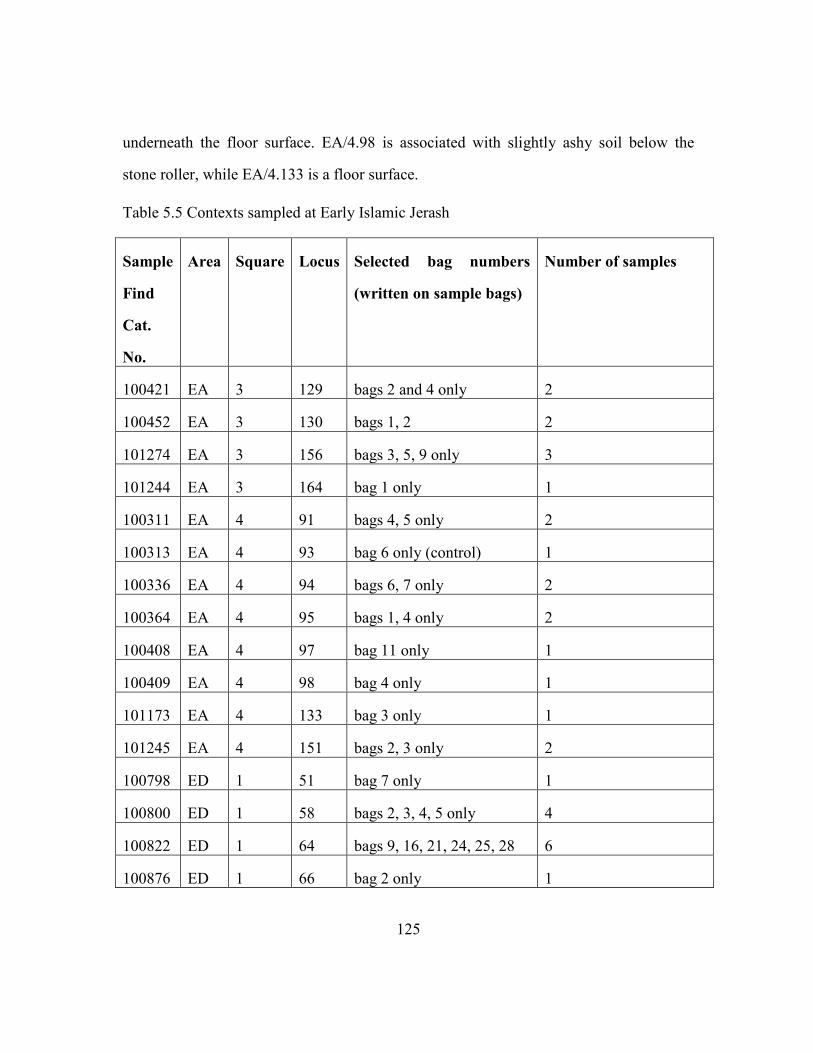
125
underneath the floor surface. EA/4.98 is associated with slightly ashy soil below the
stone roller, while EA/4.133 is a floor surface.
Table 5.5 Contexts sampled at Early Islamic Jerash
Sample
Find
Cat.
No.
Area Square Locus Selected bag numbers
(written on sample bags)
Number of samples
100421 EA 3 129 bags 2 and 4 only 2
100452 EA 3 130 bags 1, 2 2
101274 EA 3 156 bags 3, 5, 9 only 3
101244 EA 3 164 bag 1 only 1
100311 EA 4 91 bags 4, 5 only 2
100313 EA 4 93 bag 6 only (control) 1
100336 EA 4 94 bags 6, 7 only 2
100364 EA 4 95 bags 1, 4 only 2
100408 EA 4 97 bag 11 only 1
100409 EA 4 98 bag 4 only 1
101173 EA 4 133 bag 3 only 1
101245 EA 4 151 bags 2, 3 only 2
100798 ED 1 51 bag 7 only 1
100800 ED 1 58 bags 2, 3, 4, 5 only 4
100822 ED 1 64 bags 9, 16, 21, 24, 25, 28 6
100876 ED 1 66 bag 2 only 1

126
Furthermore, I sampled Area ED/1. Context ED/1. 64 is the eastern part of the
room or division in former portico space where artifacts were not particularly numerous.
Also, samples were collected from ED/1.51 which could be a floor level of occupation
build up. This area was sampled in order to test if this surface was used for food
processing. Lastly, ED/1.58 was a drainage fill. Samples were collected in order to
define the fill content of a stone drainage channel feature (locus 56 feature 10) which
was located in the middle of the west portico room running south to north bordered by
stone drainage channel (Locus 50 feature 10).
Shuqayra al-Gharbiyya: sampling contexts and justification
The site of Shuqayra al-Gharbiyya is an Early Islamic qasr and the main
occupation phase and structures date to the Early Islamic period (8th
century). Excavation
suggests ephemeral occupation during the middle and late Islamic periods that would
comply with the regional trend of 'decline' according to surveys (Shdaifat and Badhann,
2008, Jum'a Mahmoud, 2000). Agriculture flourished in the region under the
Ayyubid/Mamluk rule due to high urbanization. The Mamluk state established trade
roads, market agriculture and associated storage places in the region (Jum'a Mahmoud,
2000).
I have collected samples for botanical analysis from the Mamluk phases of
occupation (12th-14th centuries). Samples were collected form floor surfaces of the
interior of houses. The goal of the phytolith analysis from the Mamluk era contexts at
Shuqayra was to understand if peasants employed low-level mechanisms against crop
failure and food shortage, such as diversification of production and irrigation during the
middle and late Islamic periods of 'decline'. A total of sixteen samples from Shuqayra al-
Gharbiya were analyzed for this dissertation.

127
Tawahin as-Sukkar and Khirbet as-Sheikh Isa: sampling contexts and justification
Tawahin as-Sukkar and Khirbet as-Sheikh Isa are located in the Ghor Valley and
were thriving centers of Mamluk agricultural economy. At Khirbet as-Sheikh Isa the
earlier stratigraphic layers date to the Byzantine period. Also, there are two layers of
Umayyad and Abbasid occupation and three phases of Mamluk occupation. The
Ottoman settlement is located approximately five kilometers east of the site. The
Mamluk occupation is the most dominant and this is directly related to the presence of
the sugar production and processing factory nearby (Tawahin as-Sukkar). I collected
samples from both medieval sites that derived from contexts that date to the Mamluk
period. I analyzed nine sediment samples that I processed for phytolith extraction. The
samples that derived from Tawahin as-Sukkar were randomly selected among several
samples that I collected from a pile of industrial waste-material at the sugarcane factory.
In addition, I analyzed three samples from the medieval village of Khirbet as-
Sheikh Isa, that I retrieved from the storage area at the Museum of Archaeology at Safi.
One sample derived from the context a125 Trench II, one from ashy layer of Trench VII,
and one from tabun ash.
Beidha: sampling contexts and justification
The Medieval village of Beidha (12-15th centuries AD) serves as a good example
of how local communities on the peripheries of large empires expanded into marginal
farming environments, and how village-level agricultural practices could have had
lasting impacts on the localized ecology of those areas that extend into the present-day.
Phytolith analysis on samples collected from Islamic Beidha could show whether the
local community had a sustainable subsistence agricultural economy, and help us
understand their adaptive economic strategies to cope with agricultural uncertainty in the
128
absence of state-level support during bad years of inadequate rainfall. A total of forty-
two sediment samples from Beidha were analyzed for phytoliths for this dissertation.
Phytolith analyses was used to investigate our assumption that the peasants
intensified their production via irrigation at a village-level, through runoff-water farming
and the use of cisterns in the vicinity of the site. Also whether they used an agro-pastoral
economy to buffer against the uncertainty of local low crop yield during dry years.
Villagers could count on the exchange of animal by-products for grain. The population
of Beidha could make due in years of higher rainfall, but probably relied heavily on state
support during a series of drought years.
The excavated medieval site revealed three phases of occupation and a complex
of rooms, courtyards and architectural features such as animal pens, storage pits, a
storage room, pottery workshop areas, and tabuns (ovens). Most of the samples were
collected from the western part of the village (Trench A), which is an open area south of
Spatial Unit 3 (Bikai et al., 2005, Sinibaldi and Tuttle, 2011, Sinibaldi, 2015) and a few
samples analyzed for this report were collected from the eastern part of the village
(Trench B). I collected samples from all three occupation phases identified through
stratigraphic analysis of Trench A; Phase I: Stratigraphic Unit 25, Phase II: Stratigraphic
Unit 38, and Phase III: Stratigraphic Unit 13 (Sinibaldi and Tuttle 2011). I analyzed
forty-five sediment samples collected from the Islamic village in Beidha, Southern
Jordan that were processed, counted and analyzed for phytoliths (see Appendix:
Beidha)(Sinibaldi, 2015).
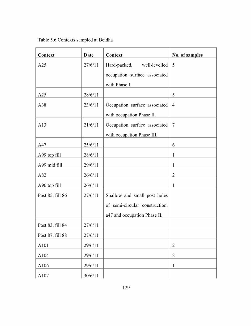
129
Table 5.6 Contexts sampled at Beidha
Context Date Context No. of samples
A25 27/6/11 Hard-packed, well-levelled
occupation surface associated
with Phase I.
5
A25 28/6/11 5
A38 23/6/11 Occupation surface associated
with occupation Phase II.
4
A13 21/6/11 Occupation surface associated
with occupation Phase III.
7
A47 25/6/11 6
A99 top fill 28/6/11 1
A99 mid fill 29/6/11 1
A82 26/6/11 2
A96 top fill 26/6/11 1
Post 85, fill 86 27/6/11 Shallow and small post holes
of semi-circular construction,
a47 and occupation Phase II.
Post 83, fill 84 27/6/11
Post 87, fill 88 27/6/11
A101 29/6/11 2
A104 29/6/11 2
A106 29/6/11 1
A107 30/6/11

130
Table 5.6 continued
A118 3/07/11
A124 5/07/11 1
B28 11/07/11 1
A116 3/07/11
A129 11/07/11 2
A10 tabun ash 10/07/10 Tabun associated with
occupation Phase III.
3
A11 soil around the
tabun
22/07/10 Tabun associated with
occupation Phase III.
1
Scrape off pot
A148 control
outside structure
next to pot
17/07/11 1
A147 pot fill bottom 1
A147 pot fill top 1
A147 pot control
sample around the
pot bottom part
1

131
SUMMARY: PHYTOLITHS IN ISLAMIC ARCHAEOLOGY
Phytolith analysis on sediments that derive from medieval villages which contain
stratified domestic deposits dating to the Mamluk rule (12th-14th centuries) were used to
reconstruct village-level subsistence strategies as a response to macro-level changes in
state agricultural economy. I used phytoliths for plant and crop identification, for
analysis of crop-processing-stage indicators and for identification of irrigation signals in
order to investigate risk buffering strategies of medieval peasant communities.
Firstly, I used multi-cell phytoliths in order to identify what were the main
economic plants and crops present on the sites under study that characterized the village-
level agricultural economies. Diversification of production is a low-level buffering
mechanism against crop failure and food shortage. Diversification of production could be
easily identified through the botanical data and used for towards identification of
intensified production during phases of economic and environmental stress. Limitations
of crop and plant identifications through phytoliths is sought to be complemented
through macro-botanical analysis and vice versa. I present the macro-botanical analysis
on samples that derived from all medieval villages sampled for phytoliths in Chapter 6.
The body of data collected (phytoliths and macro-botanical) from households and
specific contexts (hearts, pits etc.) provide direct evidence for the reconstruction of
village-level agricultural and pastoral pursuits adopted by medieval peasants and the
Mamluk state (1260-1517 AD). Samples derived from both state controlled buildings
and subsistence farmers’ buildings. The state controlled agricultural economy and the
subsistence economy of a site could be reflected in the phytolith record based on the
sampling strategy adopted.
It is necessary to incorporate the study of phytoliths into research that uses
archaeobotanical analysis for identifying the everyday life practices of peasants. Walker
132
(2011) offers an interesting approach, which combines archaeological work conducted
on the major cities and villages accounted in registers and waqfiyyat of the Mamluk
period, as well as in Ottoman tax registers of the early sixteenth century, in order to
investigate the regional implications of administrative control over local production. The
analysis of phytolith data is another strand that can and should be added to
multidisciplinary research in Islamic Archaeology.
In sum, phytoliths can provide an innovative contribution to the study of Islamic
rural history and archaeology. Future research will shed light on the investigation of
local agricultural regimes as key factors transforming regional social, demographic, and
ecological history with the use of multiple lines of evidence alongside phytolith analysis
and interpretation, such as archaeological, environmental proxy data, as well as
documentary data such studies which are under way. A systemic analysis of all these
sources can provide information land-use change and environmental and climatic
histories of the medieval Islamic periods.
133
Chapter 6: Results
This chapter presents the phytolith assemblages found within six sites sampled
for this dissertation. The site of Tell Hisban offers a rare chance to investigate historical
land use and increased demand in medieval agricultural production, on both the state and
subsistence levels. The samples derived from the Citadel and the village at the summit of
the Tell will provide direct line of evidence for studying the agro-pastoral practices at the
village-level and the control of the cereal production under the Mamluk rule.
The analysis of the micro- and macro- botanical samples collected from the early
Islamic market at Jerash, aim to examine the large scale production and market medieval
economy as well as the economic organization of the local farmers’ communities.
Phytolith data derived from Shuqayra al-Gharbiyya will shed light into village-level
economic transformations of the medieval community in this marginal area for
agricultural production. The phytolith record from Mamluk contexts at Shuqayra
indicates if peasants employed low-level mechanisms against crop failure and food
shortage such as diversification of production and irrigation under the Mamluk
agricultural rule.
Phytoliths derived from Tawahin as-Sukkar and Khirbet as-Sheikh Isa which are
located in the Ghor Valley and were thriving centers of Mamluk agricultural economy
derived from Mamluk industrial and domestic deposits, respectively. The micro- and
macro-botanical record offer evidence for the agricultural economy that sustained the
medieval villagers that most probably were the working labor of the neighboring
industrial unit. The phytolith data derived from the medieval village of Beidha (15th-
16th centuries CE) provides evidence for a subsistence agricultural economy and

134
adaptive economic strategies the local community employed to cope with agricultural
uncertainty in this marginal area for agriculture and inadequate rainfall.
Phytolith results are presented in bar charts that display absolute counts of
phytoliths per gram of sediment in order to make comparisons possible between all
samples acquired from across the different sites under study. Bar charts that compare the
amounts of single-cell phytolith forms per gram sediment are displayed separately from
bar charts that compare the amounts of multi-cell phytolith forms. Specific single-cell
phytoliths are integrated into major categories such as wood/bark phytoliths, dicot leaf
phytoliths, grass phytoliths, and single-cell rondel forms. Multi-cell phytoliths are
grouped into major categories such as leaf/stem elongate psilate, total cereal husk and
straw, phytoliths that form in dicot leaves, phytoliths that form in wood/bark, phytoliths
that form in Cyperaceae plants and wild grass husk silica skeletons.
The specific phytoliths which were grouped and the proposed archaeological
interpretations of these data are shown in Table 6.1. Cereal husks and stems in the form
of large silica skeletons which consist of more than 10 conjoined cells are considered
indicators of cereal irrigation. Identification of phytoliths was possible using the
reference collection of Rosen of the Environmental Archaeology Lab, at the University
of Texas at Austin I analyzed a total of 160 sediment samples for phytoliths for this
dissertation.
For this analysis, I emphasized the identification of major economic plants and
crops such as cereals, and date palm (Phoenix Dactylifera) (Rosen, 1992). Also,
emphasis was given to the identification of crop-processing by-products such as cereal
straw, chaff, wild grass husks (Rosen 1992, Harvey and Fuller 2005) and Cyperaceae
family plants (Ollendorf, 1992). Cyperaceae plants are considered wetland environment

135
indicators, as well as a forage crop. In addition, dicotyledonous plants (woody shrubs
and trees, fruits, and pulses) were considered during the analysis (Bozaarth, 1992).
The bar charts in this chapter compare the amounts of phytoliths per gram
sediment. Bar charts illustrate the distribution of certain phytolith forms within different
sites and various archaeological contexts.
Table 6.1 Specific phytoliths which were grouped and counted
Plant category Single-cell phytoliths counted Multi-cell phytoliths counted
Total husk Papillae, dendritic long-cell Unidentified dendritic, wheat
and barley dendritic forms
Wild Grass Husk Papillae Echinate forms, echinate forms
of more than 10 conjoined
singe-cells
Wheat husk Wheat silica skeletons, wheat
silica skeletons of more than 10
conjoined singe-cells
Cereal straw Multi-cell forms of more than 10
conjoined singe-cells, multi-cell
cereal straw forms
Cyperaceae (sedges) cones Long cell with cones
Wood of trees/shrub Globular Spheroid, Tracheids,
Silica Aggregate, Platelet,
Compound Platelet
Dicot leaves Single Polyhedron, Single Jigsaw
Puzzle
Multi-cell Polyhedron, Jigsaw
Puzzle

136
EXPLORING AGRICULTURAL AND PASTORAL ECONOMIES IN MEDIEVAL ISLAMIC
PERIODS IN JORDAN
Specific single-cell and multi-cell phytolith group categories are used to show
phytolith distribution for generating crop-processing models (Harvey and Fuller 2005).
The latter forms the basis for generating models for the agro-pastoral economy of the
medieval Islamic sites analyzed for this dissertation.
The reconstruction of agricultural-pastoral regimes and the reconstruction of
crop-processing models depend heavily on the identification and analysis of certain
multi-cell phytoliths, presented in Chapter 5 (Table 5.3). Phytoliths that form in cereal
husks, stems and wild grass husks are used as indicators of the by-products of crop-
processing stages (Harvey and Fuller 2005). Crop-processing stages can be determined
by the proportions of cereal grain, cereal chaff and weed seeds in the sample (Jones,
1984, Hillman, 1981, Harvey and Fuller, 2005). Multi-cell phytoliths of cereal straw,
wild grass husks and cereal husk were lumped together and were used as indicators for
local cereal cultivation, the identification of crop-processing areas, the presence of
fodder and the identification of potential penning areas. Cereal crops, such as wheat and
barley species, wild grass husks and cereal culms were identified based on diagnostic
multi-cell phytoliths (Rosen, 1992).
Also, identifying cereal husks and stems in the form of large silica skeletons
which consist of more than 10 conjoined cells is very important for the study of ancient
agricultural intensification regimes, such as irrigation (Jenkins et al, 2009; Madella et al.,
2009; Rosen and Weiner, 1994; Weisskopf et al., 2014). The bar charts that compare
such phytoliths per gram sediment indicate the amounts of irrigated crop present on sites
and infer agricultural intensification, potentially via irrigation, during the Middle and

137
Late Islamic periods. In particular, diagnostic multi-cell phytoliths of wheat and barley
husks, as well as cereal straw are presented in bar charts (Rosen, 1992).
Multi-cell phytoliths of cereal straw, wild grass husks, Cyperaceae and dicot
leaves were lumped together and were used as indicators of fodder and animal dung.
Also, when those phytolith forms derive from sediment samples taken from burnt
deposits they may indicate the presence of animal dung used as fuel.
Specific single-cell and multi-cell phytoliths that provide anatomical information
for dicot plants were identified and counted (see Table 6.1). Dicot phytoliths may
indicate trees and/or shrubs available in the region of study, as well as the use of trees
and/or shrubs for fuel when found on archaeological sites in hearths.
Single-cell phytoliths, such as rondels, saddles and bilobes, provide taxonomic
information for specific grass sub-families. The bar graph that compare those phytoliths
per gram sediment indicate the amounts of C3/C4 plants present on sites and infer near-
site environmental conditions.
The ratio of long-cell psilate phytoliths, that form in grass leaf/stem and cereal
culm, to long-cell dendritic phytoliths, that form in cereal husks, shows the distribution
of the greatest numbers of grass husk phytoliths across different archaeological contexts
on the sites analyzed. Also, I generated correlation coefficient graphs of weeds/straw,
cereal husk/straw, and cereal husk/weeds in order to indicate local agricultural
production. Also, these bar charts are used to indicate whether wild grass husks are
agricultural weeds or whether cereal straw is a clean product, i.e. fodder or building
material.
The first section presents bar charts from phytoliths analyzed from the Early
Islamic site of Jerash. The following two sections present bar charts from phytolith
assemblages analyzed from the Middle Islamic sites of Tell Hisban and Shuqayra al-

138
Gharbiya. The fourth section presents the bar charts from phytolith assemblages from the
Middle Islamic sites of Tawahin as-Sukkar and Khirbet as-Sheikh Isa, while the last
section presents the phytolith assemblages from the Middle/Late Islamic site of Beidha.
Jerash
The bar charts presented in this section compare phytolith assemblages from
sediment samples taken from two different shops at the Early Islamic market place at
Jerash, Northern Jordan. Overall, the shops' contexts range in date from about 600 AD to
900 AD, but the contexts probably cluster within 700 to 850 AD (see Table 6.2 for
context information below).
Figure 6.1 compares numbers per gram sediment of grass short-cells (rondels,
bilobes and saddles) present in both shops sampled for phytolith analysis. Rondels form
in C3 Pooid grasses, while bilobes and saddles generally form in C4 grasses. Panicoid
grasses produce bilobe-shaped and sometimes saddle-shaped short-cells and Chloridoid
grasses produce saddle-shaped short cells. In general, C3 plants are indicative of more
moderate climatic conditions and produce rondel-shaped short-cells. C4 Panicoid grasses
generally grow in warm and humid environments and produce bilobe- and cross-shaped
short-cell phytoliths. C4 Chloridoid grasses produce saddle-shaped short-cells and
indicate dry conditions (Twiss, et al, 1969, Twiss, 1992, Piperno, 2006).
Looking at Figure 6.1 the dominance of Pooid, C3 grasses (rondels) is clear in the
phytolith assemblage. Panicoid (bilobes) and Chloridoid grasses (saddles) are
underrepresented in the samples. The results suggest the dominance of Pooid grasses in
the site vicinity and a preference for Pooid cereals such as wheat and barley and their
cultivation nearby. Wheat and barley, which were important cultivated crops in Jordan

139
during the periods of study, are Pooid plants so this is likely to have influenced the
number of rondels present in most of the samples (Figure 6.2).
Table 6.2 List of archaeological contexts sampled at Jerash.
Area Square Locus Context
EA 3 129 Possible floor layer of a storage unit.
EA 3 130 Pit with burnt fill.
EA 3 156 Floor surface at the front of a shop that dates no earlier than
700 CE and no later than 850 CE.
EA 3 164
EA 4 91 A surface inside a well-preserved storage bin.
EA 4 93 The uppermost possible working surface associated with the
stone roller found inside the storeroom.
EA 4 94 A good level surface close to the stone roller.
EA 4 95 Sample bag 1, sediment in contact with the roller.
Sample bag 5, an ashy deposit around the roller.
EA 4 97 Sediment underneath the floor surface.
EA 4 98 Sediment associated with slightly ashy soil below stone roller.
EA 4 133 A floor surface.
EA 4 151
ED 1 51 A floor level of occupation build up.
ED 1 58 A drainage fill located in the middle of the west portico room
running south to north bordered by a stone drainage channel.
ED 1 64 A layer of fill in the eastern part of the room
ED 1 66

140
Chloridoid grasses indicate dry, hot and open pasture environments. Saddles are
found in higher densities in Square EA/3, in particular in samples EA/3.129 (2),
EA/3.130 (1,2), EA/3.164 (1). Saddles are found in lower densities in Square EA/4, in
particular in samples EA/4.91 (4) EA/4.94 (6,7), EA/4, EA/4.98 (4) and EA/4.133 (3). In
addition, saddles are generally abundant in Square ED/1. 64 and ED/1.58 (5, 2) (See
Table 6.2 for contextual information).
Figure 6.2 shows the numbers per gram sediment of multi-cell phytoliths of
economic crops present within sediments from the different shops at Jerash. The
histogram shows that phytoliths from wheat, barley and date palm are present in most
contexts. Figure 6.2 shows that dates (Phoenix dactylifera) are more abundant in samples
EA/4.94 (7) EA/4.98 (4), ED/1. 51 (7), ED/1. 58 (1, 2, 3) and ED/1.64 (9, 21). Palm
phytoliths present in the store units at Jerash indicate their important role in local diet
and the market economy. However, palm trees were most probably grown in the Jordan
valley (Figure 6.2).
Figure 6.2 shows the numbers of wheat and barley grass husk phytoliths from the
shops at Jerash. Wheat husk phytoliths are present in samples EA/3.129 (2), EA/4. 91
(4), EA/4.93 (6), EA/4. 95 (1) and EA/4. 98 (4) below the stone roller, and are generally
abundant in Squares ED/1. 58 and ED/1. 64. Barley husk phytoliths are found in samples
EA/3.129 (2), EA/3.130 (1), EA/3.156 (3), EA/3.164 (1), EA/4.95 (1), EA/4.97 (11),
ED/1.58 (5), and ED/1.64 (12, 25).
Wheat and barley husk phytolith counts seem low overall (Figure 6.2). However,
their presence in the samples imply that these were two of the main agricultural crops
that local peasant communities produced and distributed to the market of Jerash. Wheat
husk phytoliths are present in higher densities in samples EA/4.91, EA/4. 95 (1), EA/4.
98 (4) and ED/1. 64. I would suggest these contexts are either storage or possibly

141
processing of wheat areas. Samples EA/4. 95 (1) and EA/4. 98 (4) are associated with the
stone roller, which was probably used for grinding/processing grain (wheat). The
presence of wheat and barley husk phytoliths, as well as the presence of crop-processing
by-products such as cereal chaff and straw (Figures 6.3) indicate that both crops were
cultivated in the hinterland of Jerash.
Figure 6.3 shows the numbers per gram sediment of multi-cell wheat husk
phytoliths, as well as phytoliths associated with wheat processing, such as cereal straw
and weed phytoliths. The histogram provides a clearer view of the distribution of wheat
and cereal processing by-products across the different areas at the Jerash market. Wheat
husk phytoliths are present in higher densities in samples EA/4.91 , EA/4. 95 (1), EA/4.
98 (4), and ED/1. 64. The presence of wheat husks and early-stage crop-processing by-
products such as straw and agricultural weeds suggest that the eastern part of the room in
Square EA/4 could have been a space for crop-processing and grain and fodder storage.
The storage bin EA/4.91 most probably was used for the storage of wheat and barley.
Figure 6.4 shows the numbers per gram sediment of sedge, straw, weed and
barley multi-cell phytoliths, associated with dung and/or animal fodder deposits.
Phytolith multi-cell forms that derive from wild grass husks are present in all samples.
They are found in higher densities in samples, EA/3.129 (2), EA/3.130 (1), EA/3.156 (3),
EA/3.164 (1), EA/4.95 (1), ED/1.58 (5) and ED/1.64 (12, 25, 28). The pattern shown in
Figure 6.4 (straw, wild grasses, sedges, barley) indicates the presence of fodder and/or
animal dung in Square EA/3, in the storage area, on a floor surface at the front of a shop
and inside the burnt fill of a Pit. Also, store unit ED/1 was rich in straw, weed, barley
and sedge phytoliths as well. Figure 6.5 suggests the presence of animals in contexts
EA/3.129 (2) and ED/1.64 (12, 25, 28), so animals might have been kept and fed at times
in those spaces. Phytoliths associated with cereal agriculture (Total husk, cereal straw

142
and wild grass husk) are present in higher densities in samples EA/3.129, EA/3.130,
EA/3.164, and EA/4.95. Phytoliths associated with crop-processing by-products (cereal
husk and wild grass husk) are present in higher densities in samples ED/1.58 and
ED/1.64 (Figure 6.5).
Figure 6.6 shows a correlation coefficient between wheat and wild grass husks
(0.5), Figure 6.7 a correlation coefficient of higher significance between total cereal
husks and wild grass husks (0.7) and correlation between cereal straw and wild grass
husks was very low (0.2). According to the positive correlation coefficient between
weeds and total cereal husks, most of the weeds on site seem to be agricultural weeds.
Cereal straw is present in samples EA/3.129 (2), EA/3.130 (1, 2), EA/3.156 (3),
EA/3. 91 (4), EA/4.93 (6), EA/4.94 (6, 7), EA/4.98 (4), EA/4.133 (3), and in ED/1. 64.
Straw was brought to the site most probably as fodder and not as an early-stage crop-
processing by-product, as the non-significant correlation between straw and agricultural
weeds indicates (Figure 6.8). It is present in higher densities in samples EA/3.130 (1, 2)
and EA/3.156 (3) and both samples are rich in agricultural weeds too. Possibly those
samples are associated with animal fodder in front of shop EA and the use of dung as
fuel in ashy deposit EA/3.130.
Figure 6.9 compares the numbers of phytoliths from store units EA/3, EA/4 and
ED/1 found within dicots. Those phytoliths are present in the majority of the samples and
may indicate the presence of wood/bark for fuel, tinder, food storage and/or construction
material. Platey phytoliths that form in wood/bark are present in twenty-three samples
but are present in larger amounts in contexts EA/3.129, EA/3.130, EA/3.164, EA/4.91,
EA/4.94, EA/4.98, EA/4.133 and ED/1.64. Silica aggregate phytoliths that form in
wood/bark are present in large amounts in eight samples and in larger amounts on the
surface inside a well-preserved storage bin. Certain phytoliths that form in dicot leaves

143
such as polyhedral phytoliths were present in large amounts in context EA/3.130 which
is a Pit with burnt fill inside the EA/3 store unit.
Reed grasses are plants found in wetlands and produce diagnostic single-cell
keystone phytoliths and multi-cell bulliform phytoliths (Metcalfe, 1960, Ollendorf, 1992,
Ryan, 2011) (Figure 6.10). Reed phytoliths are abundant in most of the samples from
Jerash and are present in higher densities in samples EA/3.130, EA/3.156 and ED/1.66.
They are present in lower densities in samples EA/3.129, and EA/4. 91. The presence of
reed phytoliths within the ashy remains of Pit EA/3.130 shows that reeds were used as
fuel or they could have come from animal dung. Reed phytoliths, also found in the
samples derived from the floor fill, could indicate that reeds were used as construction
material (Figure 6.10).

144
Figure 6.1 Pooid, Panicoid and Chloridoid grass single-cell phytoliths
Figure 6.2 Economic crops at Jerash market place
0
500
1000
1500
2000
2500
3000
3500
4000 EA
/3. 1
29
(4
)
EA/3
. 12
9 (
2)
EA/3
. 13
0 (
1)
EA/3
. 13
0 (
2)
EA/3
.15
6 (
3)
EA/3
.15
6 (
5)
EA/3
.15
6 (
9)
EA/3
.16
4 (
1)
EA/4
.91
(4
)
EA/4
.91
(5
)
EA/4
.93
(6
)
EA/4
.94
(6
)
EA/4
.94
(7
)
EA/4
.95
(1
)
EA/4
.95
(4
)
EA/4
.97
(1
1)
EA/4
.98
(4
)
EA/4
.13
3 (
3)
ED/1
.51
(7
)
ED/1
.58
(1
)
ED/1
.58
(2
)
ED/1
.58
(3
)
ED/1
.58
(4
)
ED/1
.58
(5
)
ED/1
.64
(9
)
ED/1
.64
(2
1)
ED/1
.64
(2
4)
ED/1
.64
(2
5)
ED/1
.64
(2
8)
ED/1
.64
(1
2)
n/g
ram
se
dim
en
t
Contexts
Grass short-cells
Rondel. Bilobe Saddle
0
20
40
60
80
100
120
140
EA/3
. 12
9 (
4)
EA/3
. 12
9 (
2)
EA/3
. 13
0 (
1)
EA/3
. 13
0 (
2)
EA/3
.15
6 (
3)
EA/3
.15
6 (
5)
EA/3
.15
6 (
9)
EA/3
.16
4 (
1)
EA/4
.91
(4
)
EA/4
.91
(5
)
EA/4
.93
(6
)
EA/4
.94
(6
)
EA/4
.94
(7
)
EA/4
.95
(1
)
EA/4
.95
(4
)
EA/4
.97
(1
1)
EA/4
.98
(4
)
EA/4
.13
3 (
3)
ED/1
.51
(7
)
ED/1
.58
(1
)
ED/1
.58
(2
)
ED/1
.58
(3
)
ED/1
.58
(4
)
ED/1
.58
(5
)
ED/1
.64
(9
)
ED/1
.64
(2
1)
ED/1
.64
(2
4)
ED/1
.64
(2
5)
ED/1
.64
(2
8)
ED/1
.64
(1
2)
n/g
ram
of
sed
ime
nt
Contexs
Cereal husk phytoliths
Wheat Husk Barley Husk Echinate Spheroid (cf. palm)

145
Figure 6.3 Wheat husk, cereal straw and weed phytoliths
Figure 6.4 Phytolith evidence for fodder and/or animal dung
412
309 462 0
50
100
150
200
250
EA/3
. 12
9 (
4)
EA/3
. 12
9 (
2)
EA/3
. 13
0 (
1)
EA/3
. 13
0 (
2)
EA/3
.15
6 (
3)
EA/3
.15
6 (
5)
EA/3
.15
6 (
9)
EA/3
.16
4 (
1)
EA/4
.91
(4
)
EA/4
.91
(5
)
EA/4
.93
(6
)
EA/4
.94
(6
)
EA/4
.94
(7
)
EA/4
.95
(1
)
EA/4
.95
(4
)
EA/4
.97
(1
1)
EA/4
.98
(4
)
EA/4
.13
3 (
3)
ED/1
.51
(7
)
ED/1
.58
(1
)
ED/1
.58
(2
)
ED/1
.58
(3
)
ED/1
.58
(4
)
ED/1
.58
(5
)
ED/1
.64
(9
)
ED/1
.64
(2
1)
ED/1
.64
(2
4)
ED/1
.64
(2
5)
ED/1
.64
(2
8)
ED/1
.64
(1
2)
n/g
ram
se
dim
en
t
Contexts
Grass husk and stem phytoliths
Wheat Husk Straw Wild Grass Husks
1444 0
100
200
300
400
500
600
EA/3
. 12
9 (
4)
EA/3
. 12
9 (
2)
EA/3
. 13
0 (
1)
EA/3
. 13
0 (
2)
EA/3
.15
6 (
3)
EA/3
.15
6 (
5)
EA/3
.15
6 (
9)
EA/3
.16
4 (
1)
EA/4
.91
(4
)
EA/4
.91
(5
)
EA/4
.93
(6
)
EA/4
.94
(6
)
EA/4
.94
(7
)
EA/4
.95
(1
)
EA/4
.95
(4
)
EA/4
.97
(1
1)
EA/4
.98
(4
)
EA/4
.13
3 (
3)
ED/1
.51
(7
)
ED/1
.58
(1
)
ED/1
.58
(2
)
ED/1
.58
(3
)
ED/1
.58
(4
)
ED/1
.58
(5
)
ED/1
.64
(9
)
ED/1
.64
(2
1)
ED/1
.64
(2
4)
ED/1
.64
(2
5)
ED/1
.64
(2
8)
ED/1
.64
(1
2)
n/g
ram
se
dim
en
t
Contexts
Sedge, Grass husk and stem phytoliths
Cyperaceae Straw Wild Grass Husks Barley Husk

146
Figure 6.5 Total husk, cereal straw and wild grass husk multi-cell phytoliths
Figure 6.6 Wheat and weed correlation from Jerash samples
0
50
100
150
200
250
300
350
400
EA/3
. 12
9 (
4)
EA/3
. 12
9 (
2)
EA/3
. 13
0 (
1)
EA/3
. 13
0 (
2)
EA/3
.15
6 (
3)
EA/3
.15
6 (
5)
EA/3
.15
6 (
9)
EA/3
.16
4 (
1)
EA/4
.91
(4
)
EA/4
.91
(5
)
EA/4
.93
(6
)
EA/4
.94
(6
)
EA/4
.94
(7
)
EA/4
.95
(1
)
EA/4
.95
(4
)
EA/4
.97
(1
1)
EA/4
.98
(4
)
EA/4
.13
3 (
3)
ED/1
.51
(7
)
ED/1
.58
(1
)
ED/1
.58
(2
)
ED/1
.58
(3
)
ED/1
.58
(4
)
ED/1
.58
(5
)
ED/1
.64
(9
)
ED/1
.64
(2
1)
ED/1
.64
(2
4)
ED/1
.64
(2
5)
ED/1
.64
(2
8)
ED/1
.64
(1
2)
n/g
m s
ed
ime
nt
Contexts
Grass husk phytoliths
Total Husk Straw Wild Grass Husks
R² = 0.5235
0
50
100
150
200
250
300
350
400
450
500
0 20 40 60 80 100 120
Correlation coeficient of wheat vs. weed
Series1
Linear (Series1)

147
Figure 6.7 Total husk and weeds correlation from Jerash samples
Figure 6.8 Straw and weeds correlation from Jerash samples
R² = 0.7349
0
50
100
150
200
250
300
350
400
450
500
0 100 200 300 400 500 600 700
Correlation coefficient of TotalHusk vs. Weed
Series1
Linear (Series1)
R² = 0.2315
0
50
100
150
200
250
300
350
400
450
500
0 100 200 300 400 500
Correlation coefficient of Straw vs. Weed
Series1
Linear (Series1)
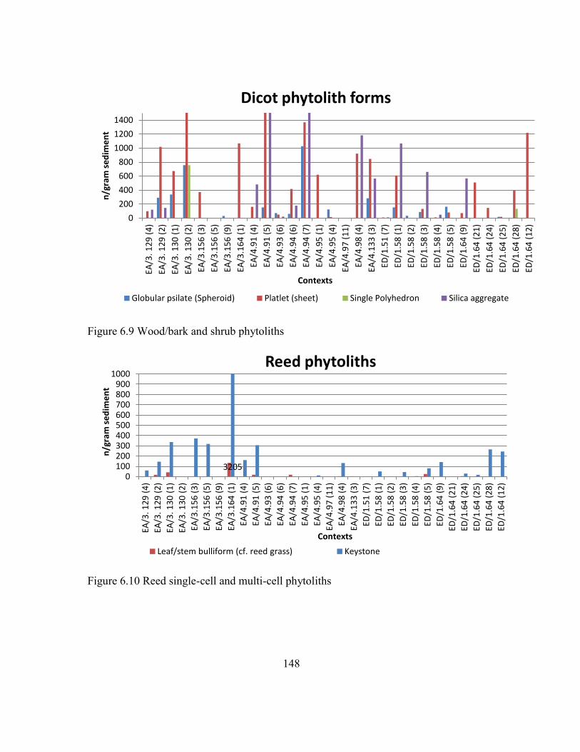
148
Figure 6.9 Wood/bark and shrub phytoliths
Figure 6.10 Reed single-cell and multi-cell phytoliths
0
200
400
600
800
1000
1200
1400
EA/3
. 12
9 (
4)
EA/3
. 12
9 (
2)
EA/3
. 13
0 (
1)
EA/3
. 13
0 (
2)
EA/3
.15
6 (
3)
EA/3
.15
6 (
5)
EA/3
.15
6 (
9)
EA/3
.16
4 (
1)
EA/4
.91
(4
)
EA/4
.91
(5
)
EA/4
.93
(6
)
EA/4
.94
(6
)
EA/4
.94
(7
)
EA/4
.95
(1
)
EA/4
.95
(4
)
EA/4
.97
(1
1)
EA/4
.98
(4
)
EA/4
.13
3 (
3)
ED/1
.51
(7
)
ED/1
.58
(1
)
ED/1
.58
(2
)
ED/1
.58
(3
)
ED/1
.58
(4
)
ED/1
.58
(5
)
ED/1
.64
(9
)
ED/1
.64
(2
1)
ED/1
.64
(2
4)
ED/1
.64
(2
5)
ED/1
.64
(2
8)
ED/1
.64
(1
2)
n/g
ram
se
dim
en
t
Contexts
Dicot phytolith forms
Globular psilate (Spheroid) Platlet (sheet) Single Polyhedron Silica aggregate
3205 0
100 200 300 400 500 600 700 800 900
1000
EA/3
. 12
9 (
4)
EA/3
. 12
9 (
2)
EA/3
. 13
0 (
1)
EA/3
. 13
0 (
2)
EA/3
.15
6 (
3)
EA/3
.15
6 (
5)
EA/3
.15
6 (
9)
EA/3
.16
4 (
1)
EA/4
.91
(4
)
EA/4
.91
(5
)
EA/4
.93
(6
)
EA/4
.94
(6
)
EA/4
.94
(7
)
EA/4
.95
(1
)
EA/4
.95
(4
)
EA/4
.97
(1
1)
EA/4
.98
(4
)
EA/4
.13
3 (
3)
ED/1
.51
(7
)
ED/1
.58
(1
)
ED/1
.58
(2
)
ED/1
.58
(3
)
ED/1
.58
(4
)
ED/1
.58
(5
)
ED/1
.64
(9
)
ED/1
.64
(2
1)
ED/1
.64
(2
4)
ED/1
.64
(2
5)
ED/1
.64
(2
8)
ED/1
.64
(1
2)
n/g
ram
se
dim
en
t
Contexts
Reed phytoliths
Leaf/stem bulliform (cf. reed grass) Keystone

149
Tell Hisban
The bar charts presented in this section compare phytolith assemblages from
sediment samples taken from the peasant households at the Mamluk village and Citadel
at Tell Hisban. Overall, the contexts sampled from both areas are middle/late Islamic
contexts and range in date from about 1250 CE to 1517 CE.
The Citadel: descriptions of bar charts
The bar charts presented in this section show the phytoliths from the Citadel at
Tell Hisban. In particular, they show the numbers of single-cell and multi-cell phytoliths
present within the storeroom of the Mamluk Governor residence, Field L, the floor and a
hearth of a domestic storage room dating between the 14th
- 16th
centuries, Field Q2 and
a 16th
century courtyard within the Citadel, Field Q5. Samples were taken from across
the floor inside the storeroom, multiple samples were taken from the ashy context within
a hearth inside the Governor's residence and across the floor of the courtyard. Bar charts
compare the amounts of single-cell and multi-cell phytoliths per gram sediment which
indicate the amounts of certain phytolith forms in all contexts.
Figure 6.11 shows the numbers per gram sediment of grass single-cell phytoliths
(rondels, saddles and bilobes) and the relative abundances (%) of grass single-cell
phytoliths. Figure 6.11 indicates the predominance of Pooid grasses (rondels), which
could indicate the presence of cereals such as wheat and barley. Wheat and barley are
Pooid grasses and may have influenced the results. The highest values of rondels are
present within the storeroom. The highest values of saddle-forms that form in Chloridoid
grasses are present within the courtyard, while saddles are almost entirely absent from
the storeroom. There are low proportions of saddles within one sample that derived from
the hearth. Chloridoid grasses indicate dry land grasses and warm and dry habitats and
their presence in samples that derived from the hearth could indicate the presence of

150
animal dung as fuel (Twiss, et al, 1969, Twiss, 1992, Piperno, 2006). Saddles
(Chloridoid leaf/stems) are likely to have entered the archaeological record as crop waste
to be used as fodder. The pattern of saddles, indicates potentially animal dung and that
animals were possibly grazing in more distant open habitats and pasture environments.
Bilobes phytolith forms that form in Panicoid grasses are present in higher densities
within the storeroom and in lower densities within the ashy remains of the hearth.
Bilobes are also found in two samples that derived from the courtyard, but in low
densities.
Figure 6.12 compares the numbers of dicot phytoliths from the different
archaeological contexts in the Citadel at Tell Hisban. The wood/bark phytolith category
contains single-form phytoliths including Globular psilate (spheroid), Plateys, Tracheids,
and Silica aggregates. Wood/bark phytoliths are present in all contexts, but they are
present in larger amounts within the storeroom, and this may indicate the wood
construction material. Also, higher densities of dicot phytoliths inside the storeroom
could indicate the storage of dicot plant foods as well. The presence of large amounts of
wood/bark phytoliths in the hearth indicates the use of wood as fuel. The dicot leaf
phytolith category is an aggregate category which incorporates polyhedral single-cell and
multi-cell forms as well as, ‘jigsaw puzzles’ (Bozarth, 1992). The phytoliths that form in
dicot leaves are found within one sample derived from the hearth. These phytolith types
are used to possibly identify the presence of animal dung as well. Figure 6.11 shows
evidence for animal dung fuel in the ashy remains of the hearth.
Because wheat was the basis of the economy of the Mamluk government in
Jordan, the production, distribution, and storage, as well as the processing and
consumption by local communities, are a main focus of the analysis of this dissertation.
Figures 6.13, 6.14 and 6.15 show the phytoliths from wheat, barley and wild grass husks

151
present in the Citadel at Tell Hisban. Figure 6.12 shows the numbers per gram sediment
of wheat (Triticum sp.) and barley (Hordeum sp.) husk silica skeletons and compares the
relative abundance (%) of wheat husk multi-cell phytoliths to barley husk multi-cell
phytoliths. Figure 6.14 compares the amounts of cereal husk phytoliths (wheat and
barley) with the numbers per gram sediment of wild grass husk silica skeletons and
compares the relative abundance (%) of cereal husk multi-cell phytoliths to wild grass
husk multi-cell phytoliths.
Figure 6.13 shows that there are wheat husk silica skeletons in large numbers
within all samples derived from the Governor's storeroom, which suggests that hulled
wheat was brought to the site and stored in storerooms in the husk. The phytolith record
suggests that wheat remained an important crop in the periods studied. In the samples
from Tell Hisban, large multi-cell wheat phytoliths, which indicate growing conditions
on wet lands and irrigation, are present in higher densities in the Governor’s storeroom
and not in the domestic contexts, where barley is also present in higher densities. Wheat
husk silica skeletons are present in small amounts in two samples that derived from the
hearth. Wheat husks most probably entered the ashy contexts of the hearth as food waste,
or through the discard of husks into the hearth. Wheat and barley husks are found in
equal amounts within the courtyard, which indicates potential fodder processing.
Phytolith data from the courtyard imply that wheat and barley plants were used as fodder
for the livestock, as well as for human consumption and storage. The presence of early
stage by-products such as grass husks and cereal straw could indicate that de-husking
and coarse sieving could have been taking place within the courtyard.
Figure 6.13 shows that barley husk phytoliths are found in smaller amounts
within the storeroom, and in larger amounts within the courtyard. One sample derived
from the ashy context contains barley husk phytoliths as well. The relevant absence of

152
barley from the samples could be used as an indirect indication that the inhabitants of
Tell Hisban did not need to turn to large-scale barley cultivation as buffering against
uncertainty and drought conditions, given the natural setting. The large multi-cell
phytoliths of wheat and barley husks, particularly the former, suggest that irrigation of
cereals took place during the Middle and Late Islamic periods. Overall, barley seems to
be a secondary crop choice, being underrepresented in the samples.
Figure 6.15 shows that larger amounts of wheat husks compared to weed grass
husks are present within the storeroom, while larger numbers of weed grass husks
compared to wheat husks are present in all samples derived from the courtyard. Figure
6.14 also shows low concentrations of weeds inside the storeroom compared to the
domestic contexts. Phytolith evidence for higher relative abundance (%) and absolute
counts of wheat husks inside the storeroom indicate the storage of clean wheat crop in
this context. The denser concentrations of weeds inside the courtyard suggest that weeds
have entered the archaeological record as crop waste to be used as fodder. The wild grass
husks present in the hearth could be the remains of dung fuel.
Figure 6.16 compares concentrations of multi-cells which indicate the presence
of crop-processing by-products, fodder and/or dung, such as cereal husks, cereal straw,
wild grass husks, and dicot leaf phytoliths. Archaeobotanists have used straw along with
high densities of some grain and wild grass husks to identify the presence of fodder
(Jones, 1984, Hillman, 1981). Interestingly, the Governor’s courtyard, Field Q5, includes
high densities of cereal straw, cereal husks, and wild grass husks, which indicates that
de-husking and coarse sieving could have been taking place, or that animals were
foddered and kept in that space. Very low densities of cereal straw are recorded in the
samples derived from the Governor’s storeroom.

153
The large quantity of straw phytoliths present in the hearth suggest the remains of
dung fuel. Figure 6.16 shows the density of sedge phytoliths, dicot leaf phytoliths, and
saddle morphotypes (Figure 6.17). These categories of phytoliths can be derived from
dung fuel. Cyperaceae (sedges) are forage plants and their existence in many samples
could indicate the presence of animal dung, depending on the context. Also, increased
numbers of saddles (chloridoid leaf/stems) are likely to have entered the archaeological
record as crop waste to be used as fodder or as animal dung. Figure 6.16 shows that
samples derived from the hearth are rich in Cyperaceae phytoliths and Chloridoid grasses
(saddle-shaped). This is possibly an indicator for animal dung used as fuel. Dicot leaf
phytolith types which are used to identify the presence of animal dung are also present in
high densities within the hearth and the courtyard.
Figure 6.18, show that reed grasses are present in almost all samples derived from
the Citadel at Tell Hisban. Figure 6.18 shows that reeds were present within the hearth
and that reeds were a source for fuel, but were not used as prominently as dicot plants
(Figures 6.19). The phytolith evidence indicates the abundance of reed phytoliths and the
presence, as well as the use of plants from wetland areas. Reeds present in the storeroom
could be the remains of roofing material or basketry used within the storage area.
Palm single-cell phytoliths are present in samples derived from the Governor's
storeroom and from the courtyard and the data could infer the importance of dates
(Phoenix dactylifera) for consumption. Dates most probably were cultivated in the
Jordan Valley and imported to the highlands (Figure 6.19).

154
Figure 6.11 Pooid, Panicoid and Chloridoid grass single-cell phytoliths
Figure 6.12 Wood/bark and shrub phytoliths
0
20000
40000
60000
80000
100000
120000
n/g
m s
ed
ime
nt
Contexts
Grass short cells
Rondels Bilobes: Saddles:
0 2000 4000 6000 8000
10000 12000 14000 16000 18000 20000
n/g
ram
se
dim
en
t
Contexts
Dicot phytoliths
Wood/bark single-cell Dicot leaf

155
Figure 6.13 Numbers of wheat and barley husk multi-cells phytoliths
Figure 6.14 Wheat, barley and weed husk multi-cells phytoliths
0
100
200
300
400
500
600
700
800
n/g
ram
se
dim
en
t
Contexts
Grass husk phytoliths
Wheat Husks Barley Husks
0
200
400
600
800
1000
1200
n/g
m s
ed
ime
nt
Contexts
Cereal husk and weed husk phytoliths
Wheat Husks Barley Husks Wild Grass Husk

156
Figure 6.15 Wheat and weed multi-cell phytoliths
Figure 6.16 Cereal straw, barley, weed and dicot leaf phytoliths
0
200
400
600
800
1000
1200 n
/gra
m s
ed
ime
nt
Contexts
Wheat husk and weed husk phytoliths
Wheat Husks Wild Grass Husk
0
200
400
600
800
1000
n/
gram
se
dim
en
t
Contexts
Sedge, grass husk and stem phytoliths
Cereal Straw Barley Husks Dicot leaf Wild Grass Husk

157
Figure 6.17 Dicot leaf, saddles and sedge phytoliths
Figure 6.18 Reed phytoliths - average numbers per gram sediments
0
2000
4000
6000
8000
10000
12000
14000 n
/gra
m s
ed
ime
nt
Contexts
Dicot, sedge and Chloridoid phytoliths
Dicot leaf Saddles: Cyperaceae L/St
0
500
1000
1500
2000
2500
n/g
ram
se
dim
en
t
Contexts
Reed phytoliths
Keystone

158
Figure 6.19 Date palm phytoliths - average numbers per gram sediment
The medieval village: Field M and Field O
This section describes the phytolith assemblages found within Archaeological
Fields M and O in the medieval village at Tell Hisban. Samples derived from Field M on
the upper northeastern and the northeastern corner of the site, and from Field O on the
southwestern slopes of the Tell. In particular, samples derived from Fields M1, M8 and
O9. Field M8 is a barrel-vaulted structure of Mamluk date and potentially could have
been used as a storehouse or a stable (Walker 2014). I took samples across the fill on top
of the floor of barrel-vaulted structure M8 (Fill M.8.7) The Fill was directly on top of a
well-plastered floor (Floor M.8.8) . I also collected samples from spatial features, which
were identified as middens located below the plaster floor (M8.9, M8.13). M8 had a hard
compact floor surface that retained plaster in certain areas. Field M1, is located below the
northeast corner tower and the fortification wall of the Citadel. This area was identified
as a Mamluk-era midden associated with the residential complex inside the Citadel in the
0
500
1000
1500
2000
2500
3000
3500 n
/gra
m s
ed
ime
nt
Contexts
Echinate Spheroid (cf. palm)
Echinate Spheroid (cf. palm)

159
14th century. I sampled two layers of fill (M1.12 and M1.13) dated to the Mamluk and
the Late Mamluk period (Walker 2014).
Field O is located on the southwestern slopes of the Tell and was part of the
larger village settlement with houses, cisterns, and courtyards, many sharing common
walls. I collected samples from a Mamluk-era farmhouse (O9). Samples derived from the
floor of the single-room farmstead, a storage bin, hearths, and a midden found inside the
household (see Table 6.3 for context information below).
Figure 6.20 shows the average numbers per gram of sediment of rondels, saddles
and bilobes. Figure 6.20 suggests the dominance of Pooid C3 grasses in Fields M and O.
Chloridoid C4 grasses and Panicoid C4 grasses are underrepresented in the samples.
Rondels are present in higher densities in the samples derived from Field M1, the Fill
layers associated with the Citadel's midden. Also, rondels are present in high densities
inside the farmhouse (Field O9) while densities of rondel morphotypes in the vaulted
building (M8) are considerably lower. Saddles that form in Chloridoid grasses are
present in higher densities in the Mamluk citadel midden (Field M1) and in three of the
samples derived from Field O9.
Figure 6.21 shows the average numbers per gram of sediment of certain
phytoliths derived from wood and bark as well as dicot leaves. Phytolith forms that are
formed in the wood and/or bark of trees or shrubs are present in higher densities in both
Fill layers of the midden of the Citadel and in one fill layer of the midden found inside
the Mamluk-era farmhouse from the nearby village. They were primarily present in
higher densities in the Pit fill found inside the Mamluk-era farmhouse, which was also
rich in dicot leaf phytoliths. The phytolith evidence indicates higher densities of dicot
phytoliths inside the storeroom which could indicate the storage of dicot plant foods
(Figure 6.21).

160
Figures 6.22, 6.23, and 6.24 show the numbers of grass husk phytoliths from
Fields M1, M8 and O9 at Tell Hisban. Phytolith evidence shows that wheat and barley
were major economic crops at Tell Hisban. Figure 6.22 shows that wheat and barley are
found in all Fields sampled, including the city midden (Field M1), the vaulted building
(Field M8) and the farmhouse (Field O9). The barrel-vaulted structure of Mamluk date,
Field M8, contains large amounts of wheat husk phytoliths, while barley husk phytoliths
are found in smaller amounts in Field M8 than in Field M1. Wheat husk phytoliths were
present in all of the samples derived from Field M8, while barley husk phytoliths were
present in three of the samples in M8.
Field M1 is rich in wheat husk phytoliths, although these are present in slightly
lower amounts than in Field M8. On the contrary, barley husk phytoliths are present in
higher amounts in the Fill Layers of Field M1, compared to Field M8 (Figure 6.22).
Barley husk phytoliths are present in all of the samples derived from the two Fill layers
in Field M1, while wheat husk phytoliths are absent from one sample.
The phytolith record from the farmstead (Field O9) revealed that peasants had
access to wheat and barley crops (Figures 6.22). Wheat seems to be an abundant crop
and of great importance to the peasants at Hisban. Wheat and barley husk phytoliths are
present in higher densities in the five Fill layers in the midden found inside the single-
room farmhouse. Also, higher densities of wheat are present in two samples from the
surface right on top of the plaster floor and a sample derived from the fill inside a cut in
the northwest corner of the single-room farmstead. Cereal husks were absent from the
samples derived from the fill inside a Pit excavated inside Field O9.
Figure 6.23 compares the numbers of wild grass husk phytoliths from across the
different Fields sampled. High densities in wild grass husks indicate early crop-
processing stage activities or animal dung ash indicating cooking. The presence of high

161
densities of identified wheat and barley husks as well as weed phytoliths depict a mixed
sample composition. Phytolith evidence for lower relative absolute counts of wild grass
husks inside the barrel-vaulted structure, Field M8, could indicate the deposition of
clean cereal crop in this context. Barley and wild grass husk seem to be present in all
samples derived from Field M1, in four of the five fill layers of the midden inside the
farmstead, and in three samples derived from Field M8 (Figure 6.24).
Figure 6.25 shows the numbers of wild grass husk, total cereal husk and cereal
straw phytoliths which indicate early and/or late crop-processing stage activities
depending on the crop husbandry practices employed and crop species cultivated at Tell
Hisban. An observed pattern in the phytolith assemblage is the concentration of cereal
straw, wild grass husk and sedge phytoliths in higher densities and is present in the
samples from Field M1 and Field O9 (Figure 6.25). Cereal straw was almost totally
absent from Field M8.
The presence of large multi-cell straw, wild grass husk, and cereal husk
phytoliths in the household middens, indicates that the peasants had access to primary
crop-processing by-products and also indicates that cereals were locally produced. Figure
6.24 compares the numbers per gram of sediment of multi-cells which indicate the
presence of crop-processing by-products, fodder and/or dung, such as cereal husks,
cereal straw, wild grass husks, and dicot leaf phytoliths.
Figure 6.27 shows the distribution of multi-cell wheat husk phytoliths of more
than ten conjoined single-cells which may indicate irrigated cereal crops. Looking at
Figure 6.27 it is apparent that although some irrigated cereals were present in samples
that were collected from the farmstead of the village settlement. These are present in
higher densities in the Citadel's midden. This indicates that storage and control of
irrigated wheat was of great importance in agricultural management.

162
Water-loving plants are indicators of micro-environments near the site. The same
time the presence of Cyperaceae plants is ubiquitous in all samples, suggesting that the
environment never became extremely arid (Figure 6.26).
Reed phytoliths were generally abundant in the samples derived from Fields M1,
M8 and O9 (Figure 6.29). Reed phytoliths are present in higher densities in three of the
samples collected from midden M1. They are present in both Fill layers (Fill M1.12 and
M1.13). Also, they are present in higher densities in three of the samples derived from
the midden sampled in Field M8 and in two samples derived from the floor surface and
the midden in the farmstead (Field O9) (Figure 6.29). The water loving plants’ presence
could indicate indirectly the choice of wheat and barley cultivation, favored by wetter
conditions. (Ollendorf, 1992).
Table 6.3 Archaeological contexts sampled at Tell Hisban.
Sample ID Field and locus information Context
M1.l12.p.64 Field M1, Locus 12, Pail 64 North bulk side, northeast area of
midden, ashy deposit
M1.l13.p64 Field M1, Locus 13, Pail 64 North side of the locus, sample bag 2
M1.l13.p64 Field M1, Locus 13, Pail 64 Southwest side of locus, sample bag 3
M1.l13.p64 Field M1, Locus 13, Pail 64 Centre of locus, sample bag 4
M1.l13.p64 Field M1, Locus 13, Pail 64 West side of locus, sample bag 5
M1.l13.p64 Field M1, Locus 13, Pail 64 West side of locus, sample bag 6
M8. l.9 p.38 Filed M8, Locus 9, Pail 38 Layer under plaster, midden
M8. l.9 p.38 Filed M8, Locus 9, Pail 38 Layer under plaster, midden
M8. l.9 p.38 Filed M8, Locus 9, Pail 38 Layer under plaster, midden
M8. l.9 p.38 Filed M8, Locus 9, Pail 38 Layer under plaster, midden

163
Table 6.3 Continued
M8. l.9 p.39 Filed M8, Locus 9, Pail 38 Red-clay layer, midden
M8. l.9 p.39 Filed M8, Locus 9, Pail 38 Dark grey layer, midden
M8. l.9 p.39 Filed M8, Locus 9, Pail 38 Ashy layer, midden
O9 l.14 p.41 Field O9, Locus 14, Pail 41 Fill on floor
O9 l.14 p.41 Field O9, Locus 14, Pail 41 Fill on floor
O9 l.14 p.41 Field O9, Locus 14, Pail 41 Fill on floor
O9 l.14 p.41 Field O9, Locus 14, Pail 41 Fill on floor
O9 l.15 p.41 Field O9, Locus 15, Pail 41 Layer on top of plaster, midden
O9 l.15 p.41 Field O9, Locus 15, Pail 41 Layer on top of plaster, midden
O9 l.15 p.41 Field O9, Locus 15, Pail 41 Layer on top of plaster, midden
O9 l.15 p.41 Field O9, Locus 15, Pail 41 Layer on top of plaster, midden
O9 l.15 p.41 Field O9, Locus 15, Pail 41 Red-clay layer, midden on top of
plaster floor
O9 l.15 p.41 Field O9, Locus 15, Pail 41 Right on top of plaster
O9 l.15 p.41 Field O9, Locus 15, Pail 41 Right on top of plaster
O9 l.17 p.41 Field O9, Locus 17, Pail 41 Cut fill SE of NW corner
O9 l.29 Field O9, Locus 29 Pit fill
O9 l.26 p.49 Field O9, Locus 29, Pail 49 Pit fill
O9 l.26 p.49 Field O9, Locus 29, Pail 49 Pit fill
O9 l.26 p.49 Field O9, Locus 29, Pail 49 Pit fill
O9 L9. p38 Field O9, Locus 9, Pail 38
O9 L9. p38 Field O9, Locus 9, Pail 38

164
Figure 6.20 Pooid, Panicoid and Chloridoid grass single-cell phytoliths
Figure 6.21 Wood/bark and shrub phytoliths
0
20000
40000
60000
80000
100000
120000
140000
M1
l.1
2 p
.64
M1
.l.1
3 p
.64
M1
l.1
3 p
.64
M1
l.1
3 p
.64
M1
l.1
3 p
.64
O9
b l.
14
p.4
1
O9
b l.
14
p.4
1
O9
b l.
14
p.4
1
O9
b l.
15
p.4
1
O9
b l.
15
p.4
1
O9
b l.
15
p.4
1
O9
b l.
15
p.4
1
O9
b l.
15
p.4
1
O9
b l.
15
p.4
1
O9
b l.
15
p.4
1
O9
b l.
17
p.4
1
O9
b l.
29
O9
b l.
26
p.4
9
O9
b l.
26
p.4
9
O9
b l.
26
p.4
9
M8
l.9
p.3
8
M8
l.9
p.3
8
M8
l.9
p.3
8
M8
l.9
p.3
8
M8
l.9
p.3
9
M8
l.9
p.3
9
M8
l.9
p.3
9
n/g
ram
se
dim
en
t
Contexts
Grass short cells
Bilobe Rondels Saddle
0.00
10000.00
20000.00
30000.00
40000.00
50000.00
60000.00
70000.00
80000.00
90000.00
100000.00
M1
l.1
2 p
.64
M1
.l.1
3 p
.64
M1
l.1
3 p
.64
M1
l.1
3 p
.64
M1
l.1
3 p
.64
O9
b l.
14
p.4
1
O9
b l.
14
p.4
1
O9
b l.
14
p.4
1
O9
b l.
15
p.4
1
O9
b l.
15
p.4
1
O9
b l.
15
p.4
1
O9
b l.
15
p.4
1
O9
b l.
15
p.4
1
O9
b l.
15
p.4
1
O9
b l.
15
p.4
1
O9
b l.
17
p.4
1
O9
b l.
29
O9
b l.
26
p.4
9
O9
b l.
26
p.4
9
O9
b l.
26
p.4
9
M8
l.9
p.3
8
M8
l.9
p.3
8
M8
l.9
p.3
8
M8
l.9
p.3
8
M8
l.9
p.3
9
M8
l.9
p.3
9
M8
l.9
p.3
9
n/g
ram
se
dim
en
t
Contexts
Dicot phytoliths
Wood/bark Dicot leaf
Pit Fill
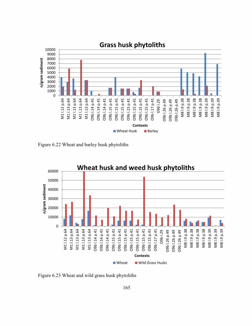
165
Figure 6.22 Wheat and barley husk phytoliths
Figure 6.23 Wheat and wild grass husk phytoliths
0 1000 2000 3000 4000 5000 6000 7000 8000 9000
10000
M1
l.1
2 p
.64
M1
.l.1
3 p
.64
M1
l.1
3 p
.64
M1
l.1
3 p
.64
M1
l.1
3 p
.64
O9
b l.
14
p.4
1
O9
b l.
14
p.4
1
O9
b l.
14
p.4
1
O9
b l.
15
p.4
1
O9
b l.
15
p.4
1
O9
b l.
15
p.4
1
O9
b l.
15
p.4
1
O9
b l.
15
p.4
1
O9
b l.
15
p.4
1
O9
b l.
15
p.4
1
O9
b l.
17
p.4
1
O9
b l.
29
O9
b l.
26
p.4
9
O9
b l.
26
p.4
9
O9
b l.
26
p.4
9
M8
l.9
p.3
8
M8
l.9
p.3
8
M8
l.9
p.3
8
M8
l.9
p.3
8
M8
l.9
p.3
9
M8
l.9
p.3
9
M8
l.9
p.3
9
n/g
ram
se
dim
en
t
Contexts
Grass husk phytoliths
Wheat Husk Barley
0
10000
20000
30000
40000
50000
60000
M1
l.1
2 p
.64
M1
.l.1
3 p
.64
M1
l.1
3 p
.64
M1
l.1
3 p
.64
M1
l.1
3 p
.64
O9
b l.
14
p.4
1
O9
b l.
14
p.4
1
O9
b l.
14
p.4
1
O9
b l.
15
p.4
1
O9
b l.
15
p.4
1
O9
b l.
15
p.4
1
O9
b l.
15
p.4
1
O9
b l.
15
p.4
1
O9
b l.
15
p.4
1
O9
b l.
15
p.4
1
O9
b l.
17
p.4
1
O9
b l.
29
O9
b l.
26
p.4
9
O9
b l.
26
p.4
9
O9
b l.
26
p.4
9
M8
l.9
p.3
8
M8
l.9
p.3
8
M8
l.9
p.3
8
M8
l.9
p.3
8
M8
l.9
p.3
9
M8
l.9
p.3
9
M8
l.9
p.3
9
n/g
ram
se
dim
en
t
Contexts
Wheat husk and weed husk phytoliths
Wheat Wild Grass Husks

166
Figure 6.24 Wild grass husk, barley and wheat husk phytoliths
Figure 6.25 Total cereal husk, cereal straw and wild grass husk phytoliths
0
5000
10000
15000
20000
25000
30000
35000
40000
M1
l.1
2 p
.64
M1
.l.1
3 p
.64
M1
l.1
3 p
.64
M1
l.1
3 p
.64
M1
l.1
3 p
.64
O9
b l.
14
p.4
1
O9
b l.
14
p.4
1
O9
b l.
14
p.4
1
O9
b l.
15
p.4
1
O9
b l.
15
p.4
1
O9
b l.
15
p.4
1
O9
b l.
15
p.4
1
O9
b l.
15
p.4
1
O9
b l.
15
p.4
1
O9
b l.
15
p.4
1
O9
b l.
17
p.4
1
O9
b l.
29
O9
b l.
26
p.4
9
O9
b l.
26
p.4
9
O9
b l.
26
p.4
9
M8
l.9
p.3
8
M8
l.9
p.3
8
M8
l.9
p.3
8
M8
l.9
p.3
8
M8
l.9
p.3
9
M8
l.9
p.3
9
M8
l.9
p.3
9
n/g
ram
se
dim
en
t
Contexts
Cereal husk and weed husk phytoliths
Wheat Barley Wild Grass Husks
0
5000
10000
15000
20000
25000
30000
35000
40000
M1
l.1
2 p
.64
M1
.l.1
3 p
.64
M1
l.1
3 p
.64
M1
l.1
3 p
.64
M1
l.1
3 p
.64
O9
b l.
14
p.4
1
O9
b l.
14
p.4
1
O9
b l.
14
p.4
1
O9
b l.
15
p.4
1
O9
b l.
15
p.4
1
O9
b l.
15
p.4
1
O9
b l.
15
p.4
1
O9
b l.
15
p.4
1
O9
b l.
15
p.4
1
O9
b l.
15
p.4
1
O9
b l.
17
p.4
1
O9
b l.
29
O9
b l.
26
p.4
9
O9
b l.
26
p.4
9
O9
b l.
26
p.4
9
M8
l.9
p.3
8
M8
l.9
p.3
8
M8
l.9
p.3
8
M8
l.9
p.3
8
M8
l.9
p.3
9
M8
l.9
p.3
9
M8
l.9
p.3
9
n/g
ram
se
dim
en
t
Contexts
Cereal husk, weed husk and cereal stem phytoliths
Total husk Cereal Straw Wild Grass Husks

167
Figure 6.26 Dicot leaf, sedges, cereal straw and wild grass husk phytoltihs
Figure 6.27 Multi-cell wheat phytoliths of > 10 conjoined single-cells
0
2000
4000
6000
8000
10000
12000
14000
16000
18000
20000
M1
l.1
2 p
.64
M1
.l.1
3 p
.64
M1
l.1
3 p
.64
M1
l.1
3 p
.64
M1
l.1
3 p
.64
O9
b l.
14
p.4
1
O9
b l.
14
p.4
1
O9
b l.
14
p.4
1
O9
b l.
15
p.4
1
O9
b l.
15
p.4
1
O9
b l.
15
p.4
1
O9
b l.
15
p.4
1
O9
b l.
15
p.4
1
O9
b l.
15
p.4
1
O9
b l.
15
p.4
1
O9
b l.
17
p.4
1
O9
b l.
29
O9
b l.
26
p.4
9
O9
b l.
26
p.4
9
O9
b l.
26
p.4
9
M8
l.9
p.3
8
M8
l.9
p.3
8
M8
l.9
p.3
8
M8
l.9
p.3
8
M8
l.9
p.3
9
M8
l.9
p.3
9
M8
l.9
p.3
9
n/g
ram
se
dim
en
t
Contexts
Dicot, sedge, cereal stem and weed husk phytoliths
Dicot leaf Cyperaceae L/St Cereal Straw Wild Grass Husks
0
20
40
60
80
100
120
M1
l.1
2 p
.64
M1
.l.1
3 p
.64
M1
l.1
3 p
.64
M1
l.1
3 p
.64
M1
l.1
3 p
.64
O9
b l.
14
p.4
1
O9
b l.
14
p.4
1
O9
b l.
14
p.4
1
O9
b l.
15
p.4
1
O9
b l.
15
p.4
1
O9
b l.
15
p.4
1
O9
b l.
15
p.4
1
O9
b l.
15
p.4
1
O9
b l.
15
p.4
1
O9
b l.
15
p.4
1
O9
b l.
17
p.4
1
O9
b l.
29
O9
b l.
26
p.4
9
O9
b l.
26
p.4
9
O9
b l.
26
p.4
9
M8
l.9
p.3
8
M8
l.9
p.3
8
M8
l.9
p.3
8
M8
l.9
p.3
8
M8
l.9
p.3
9
M8
l.9
p.3
9
M8
l.9
p.3
9
n/g
ram
se
dim
en
t
Contexts
Wheat husk phytoliths
Wheat mulit-cell

168
Figure 6.28 Single-cell palm phytoliths
Figure 6.29 Reed phytoliths
0
2000
4000
6000
8000
10000
12000
M1
l.1
2 p
.64
M1
.l.1
3 p
.64
M1
l.1
3 p
.64
M1
l.1
3 p
.64
M1
l.1
3 p
.64
O9
b l.
14
p.4
1
O9
b l.
14
p.4
1
O9
b l.
14
p.4
1
O9
b l.
15
p.4
1
O9
b l.
15
p.4
1
O9
b l.
15
p.4
1
O9
b l.
15
p.4
1
O9
b l.
15
p.4
1
O9
b l.
15
p.4
1
O9
b l.
15
p.4
1
O9
b l.
17
p.4
1
O9
b l.
29
O9
b l.
26
p.4
9
O9
b l.
26
p.4
9
O9
b l.
26
p.4
9
M8
l.9
p.3
8
M8
l.9
p.3
8
M8
l.9
p.3
8
M8
l.9
p.3
8
M8
l.9
p.3
9
M8
l.9
p.3
9
M8
l.9
p.3
9
n/g
ram
se
dim
en
t
Contexts
Echinate Spheroid (cf. palm)
Echinate Spheroid (cf. palm)
0
500
1000
1500
2000
2500
3000
3500
4000
M1
l.1
2 p
.64
M1
.l.1
3 p
.64
M1
l.1
3 p
.64
M1
l.1
3 p
.64
M1
l.1
3 p
.64
O9
b l.
14
p.4
1
O9
b l.
14
p.4
1
O9
b l.
14
p.4
1
O9
b l.
15
p.4
1
O9
b l.
15
p.4
1
O9
b l.
15
p.4
1
O9
b l.
15
p.4
1
O9
b l.
15
p.4
1
O9
b l.
15
p.4
1
O9
b l.
15
p.4
1
O9
b l.
17
p.4
1
O9
b l.
29
O9
b l.
26
p.4
9
O9
b l.
26
p.4
9
O9
b l.
26
p.4
9
M8
l.9
p.3
8
M8
l.9
p.3
8
M8
l.9
p.3
8
M8
l.9
p.3
8
M8
l.9
p.3
9
M8
l.9
p.3
9
M8
l.9
p.3
9
n/g
ram
se
dim
en
t
Contexts
Reed phytoliths
Keystone Leaf/stem bulliform (cf. reed grass)

169
Shuqayra al-Gharbiyya
The site of Shuqayra al-Gharbiyya, is an Early Islamic castle (qasr) and the main
occupation phase and structures date to the Early Islamic period (8th
century). Excavation
suggests ephemeral occupation during the middle and late Islamic periods that would
comply with the regional trend of 'decline' according to surveys (Shdaifat and Badhan,
2008, Jum'a Mahmood 2000). Agriculture flourished under the Ayyubid/Mamluk rule
due to expanded urbanization. The Mamluk state established trade roads, market
agriculture and associated storage places in the region (Jum'a Mahmoud, 2000). I
collected samples from three Mamluk occupation surfaces at the site, dating to the 14th
century (Shq. 2011, Area A Sq. E1 Loci 18, 19, 14).
Figure 6.31 shows phytolth densities of C3 versus C4 grasses present on the site
during the Middle and Late Islamic periods. Pooid C3 grasses are present in larger
amounts than Panicoid and Chloridoid grasses which are underrepresented in the
samples. The results suggest the dominance of Pooid grasses in the site vicinity and a
preference for Pooid cereals.
From the phytolith record of the contexts of Mamluk Shuqayra, it appears that
cereal production was important for the economy of Shuqayra and that wheat remained
the most common and important crop (Figure 6.32). Crop-processing indicators suggest
early processing stages in all samples acquired from the three occupation floors. This
shows that wheat production was local (Figure, 6.33). At the same time, the same cannot
be assumed for barley which seems to be a secondary crop choice, due to its
underrepresentation in the samples (Figure 6.32).
The hypothesis for local wheat production and processing is further supported
through the positive correlation coefficient graphs, of weeds versus straw (Figure 6.34),
and husk versus straw (Figure 6.36) and husks versus weeds (Figure 6.37) from Mamluk

170
Shuqayra floors. Figure 6.35 shows a lower correlation between wild grass husks and
barley husks (0.24). This may indicate barley was brought to the site as fodder crop, and
not as an agricultural weed based on the low correlation between barley husks and weed
husks.
Table 6.4 Cereal crops used in Mamluk Shuqayra al-Gharbiyya
Sample ID
Hulled barley (Hordeum vulgare)
Hard wheat/ (Triticum turgidum ssp. durum)
Bread wheat seeds (Triticum aestivum ssp. aestivum)
Two-row barley (Hordeum vulgare ssp. distichum)
Emmer wheat (Triticum turgicum ssp. dicoccon)
Table 6.5 Fruits and pulses used in Mamluk Shuqayra al-Gharbiyya
Sample ID
common pea (Pisum sativum)
bitter vetch (Vicia ervillia)
broad bean (Vicia faba)
broad bean/chickling/vetchling (Vicia faba/Lathyrus sativus),
lentil (Lens culinaris)
chick pea (Cicer arietinum)
grape (Vitis vinifera)
fig (Ficus carica)
olive (Olea europeae)
almond (Prunis dulcis)
peach (Prunis persica)

171
Another interesting trend observed in the data (Figure 6.33) is the presence of the
Cyperaceae plant phytoliths in single-cell and multi-cell forms in all occupation floors.
Moist micro-environments may have been dominant around the sites in spite of the
aridity of the region. Wet conditions and marshy environments could be close to the site
where animals could graze. Sedges could have entered the site either as accessible plants
to the villagers in the site vicinity in marshy areas or sedges entered the site as forage
plants assuming that the inhabitants have been agro-pastoralists and kept their livestock
in this settlement. The animal dung present in the macro-botanical assemblage indicates
that the inhabitants were agro-pastoralists and dung was of economic value.
Figures 6.38 and 6.39 show that certain phytoliths that derive from dicot leaves
such as polyhedral multi-cell forms and ‘jigsaw puzzles’ are present in the samples
(Bozaarth,, 1992).
The macro-botanical assemblages collected form Shuqayra al-Gharbiya show a
diverse regime of cereal crops, but free threshing cereals were dominant (see Table 6.4).
We can deduce from this information that free threshing cereals, hulled barley, and hard
wheat played a more major role in the diets of the site’s inhabitants and domesticated
animals and were important economic crops, while bread wheat and emmer wheat, a
glume wheat, would have played a minor role in the diet and local economy. There were
also a wide variety of fruits and pulses at the site (Table 6.5).
The wild species identified in the macro-botanical assemblage included Neslia
paniculata, Galium sp., Silene sp., Alkanna sp., Calendula sp., Malvaceae,
Ajuga/Teucrium sp., Boraginaceae, Hyoscyamus sp., Medicago sp., Eleocharis sp.,
Phalaris sp., Rosaceae, and several Poaceae (wild grasses).

172
Figure 6.30 Phytolith densities in all contexts from Shuqayra al-Gharbiyya
Figure 6.31 Pooid, Panicoid and Chloridoid grass single-cell phytoliths
0
200000
400000
600000
800000
1000000
1200000
1400000 n
/gm
se
dim
en
t
Contexts, florr surface 19, 14 and 18
Total phytoliths
Total single-cell Total multi-cell
0
50000
100000
150000
200000
250000
300000
19.1 19.3 19.5 19.9 19.12 19.17 ashy 1
ashy 3
14.1 14.3 14.6 14 ten
14.14 18.2 18.7 18.6
n/g
ram
se
dim
en
t
Contexts: floor surface 19, 14, and 18
Grass short cells
Rondel total Bilobes: Saddles:

173
Figure 6.32 Wheat, barley and Unident husk phytoliths
Figure 6.33 Cyperaceae, cereal straw and wild grass husk phytoliths
0
2000
4000
6000
8000
10000
12000 n
/gra
m s
ed
ime
nt
Contexts: floor surface 19, 14 and 18
Grass husk phytoliths
Barley Total Wheat Total Undet husk total
0
2000
4000
6000
8000
10000
12000
19.1 19.3 19.5 19.9 19.12 19.17 ashy 1
ashy 3
14.1 14.3 14.6 14 ten
14.14 18.2 18.7 18.6
n/g
m s
ed
ime
nt
Contexts
Sedge, grass stem and weed husk phytoliths
Cyperaceae Straw Wild grass

174
Figure 6.34 Total cereal straw and weeds correlation
Figure 6.35 Barley husk straw and weeds correlation
R² = 0.7155
0
2000
4000
6000
8000
10000
12000
0 1000 2000 3000 4000 5000 6000
Correlation coefficient of straw vs. weed
straw/weed
R² = 0.2433
0
2000
4000
6000
8000
10000
12000
0 200 400 600 800 1000 1200
Correlation coefficient of barley vs. weed
barley/weed
Linear (barley/weed)

175
\
Figure 6.36 Total cereal husk straw and cereal straw correlation
Figure 6.37 Total cereal husk and weeds correlation
R² = 0.6929
0
2000
4000
6000
8000
10000
12000
0 5000 10000 15000 20000
Correlation coefficient of cereal husk vs. straw
husk tot/straw
Linear (husk tot/straw)
R² = 0.6929
0
2000
4000
6000
8000
10000
12000
0 5000 10000 15000 20000
Coreelation coefficient of cereal husk vs. weed
husk tot/weed
Linear (husk tot/weed)

176
Figure 6.38 Wood/bark and shrub phytoliths
Figure 6.39 Dicot leaf phytoliths
0
2000
4000
6000
8000
10000
12000
14000
16000
18000
20000
19.1 19.3 19.5 19.9 19.12 19.17 ashy 1
ashy 3
14.1 14.3 14.6 14 ten
14.14 18.2 18.7 18.6
n/g
ram
se
dim
en
t
Contexts
Dicot phytoliths
Smooth Spheroid Tracheids Platey Sheet
0
500
1000
1500
2000
2500
3000
3500
4000
4500
5000
19.1 19.3 19.5 19.9 19.12 19.17 ashy 1
ashy 3
14.1 14.3 14.6 14 ten
14.14 18.2 18.7 18.6
n/g
ram
se
dim
en
t
Contexts
Dicot leaf phytoliths
Single Polyhedron Single Jigsaw puzzle Polyhedron Jigsaw Puzzle

177
Tawahin as-Sukkar and Khirbet as-Sheikh Isa
The data for phytolith analysis from the Medieval village of Khirbet as-Sheikh
Isa and the industrial unit of Tawahin as-Sukkar, one of the largest sugarcane factories of
the region, offer information on medieval Mamluk industrial and agricultural economy.
Data collected from six layers of waste deposits at the sugarcane factory and
analyzed for phytoliths provide information on the use of fuel when the sugarcane
industry flourished. Results clearly show that most of the phytoliths representing fuel use
come from dicot plants (Figure 6.41). Certain phytoliths that derive from dicot leaves
such as polyhedral multi-cell forms and ‘jigsaw puzzles’ are present in the samples
(Bozaarth, 1992). They indicate the use of trees and/or shrubs available in the region for
fuel. During an ethnographic study in Greece Tsartsidou et al. (2007) showed that the
‘jigsaw puzzle’ phytolith forms are produced by deciduous and nondeciduous trees,
legumes, and shrubs and that they are likely to be formed in regions of humid climate,
high precipitation, and/or heavy irrigation. However, looking at the absolute counts of
dicot leaves and wood/bark phytoliths present in the samples, it is obvious that the
inhabitants of the site were using a larger amount of wood and bark for fuel, compared
with dicot leaves. The presence of dicot leaves may suggest that leaves could be attached
to the wood used for fuel and/or from shrubby plants used for tinder.
In addition, the phytolith evidence show that leaves and other parts of palms
(Phoenix dactylifera) were also used for fuel at the sugarcane factory (Figure 6.41).
Interestingly, there is a notable increase in the absolute counts of echinate spheroid
phytoliths from palms in one of the industrial waste’s layers, while the counts of dicot
phytolith forms in that layer are considerably lower. For some reason, it seems that either
a certain activity taking place at the factory required the burning of palms or maybe dicot
leaves and/or wood and bark were not available in the amounts needed for processing

178
sugarcane at the factory for a certain period of time. Perhaps palms were an alternative
source of fuel, and it also seems to be a dominant species in the environment surrounding
the sites. This is indicated by the high absolute counts of palm phytoliths in both the
sugarcane factory waste deposits and the domestic deposits in the Medieval village
nearby. Also, reed grasses seem to be a source for fuel as well. The data reflect the use of
sugarcane stalks used for fuel at the factory, but this source of fuel is not as prominent as
palms and dicot plants (Figures 6.40 and 6.41). Overall, data from this pile of industrial
waste next to the factory offer direct evidence for the continuous use of wood for fuel in
the region for the century in which the factory was in use.
The samples that derive from the domestic deposits of the Medieval village
adjacent to the factory provide information on the impact that the mono-cropping,
sugarcane plantation economy had on the local economy and potentially the
environment. Also, data provide information on the village-level economy of the local
peasant communities, who were the workers employed at the factory. The study of
phytoliths from these deposits shows very low counts of wheat and cereal straw, while
barley is totally absent (Figure 6.40). State-controlled economic practices related to the
sugar plantations may have not allow for the widespread cultivation of wheat or barley,
major staples of the Mamluk period in Jordan, or for the cultivation of plants of the
Cucurbitaceae family. This community might not have depended heavily on the
agricultural production of the two main cereal crops. However, the phytolith data from
burnt features such as the ash pit, the tabun, and burnt deposits on floor surface were rich
in phytoliths of wild grasses, sedges, and dicot leaves. Limited numbers of husks of
irrigated, large multi-cell wheat silica skeletons were also found in the ash pit.
These data point to the extensive use of dung for fuel in the village of Khirbet as-
Sheikh Isa (Charles, 1996; Hillman, 1981; Palmer, 1998; Van der Veen, 1999). It is

179
likely that the inhabitants of Khirbet as-Sheikh Isa were relying on a small-scale agro-
pastoral economy and were depending on the cultivation of wheat, possibly in small
irrigated plots. In general, this analysis could indicate that while the sugarcane factory
was in use, sugar plantations took over the environment and altered the ecologies of this
fertile and important region for agriculture profoundly. The economic crop species found
included hulled Hordeum vulgare, which was the most common, followed by Triticum
turgidum ssp. durum/Triticum aestivum ssp. aestivum and Triticum turgidum ssp.
dicoccon. Wild grass species (Poaceae) present on site included one cf. Hordeum vulgare
ssp. spontaneum (wild barley) seed.
Sugar cultivation interrupted the traditional planting schedule in the region of
Ghor (Walker, 2011). As a result of this, local communities must have suffered a great
decrease in resources such as wheat and barley which were the main staples at the time
as well as after state withdrawal. People would have been unprepared to adjust to the
state withdrawal during the late 14th
century, a state that sustained the big agricultural
and industrial sector of sugarcane for a century. Sugar production was closely monitored
by the muqta’ and often the Sultan himself and replaced other crops and customary water
sharing agreements (Walker, 2011). The intensive cultivation of this labor and water-
demanding crop would have led to a greatly depleted environment. Only one pulse seed
was found (potentially identifiable Fabaceae). Both Vitis vinifera and Ziziphus spina-
christi (Christ’s thorn) seeds/fruits were present in one sample and may be an indication
of food waste or incidental discard on the foundation surface.

180
Figure 6.40. Agricultural and pastoral pursuits in Khirbet as-Sheikh Isa.
0
1000
2000
3000
4000
5000
6000
ash pit ash pit ash pit ash pit Floor 4 burnt deposit
Floor 4 burnt deposit
Taboon
n/g
ram
se
dim
en
t
Contexts
Phytolith evidence for agro-pastoral pursuits, Khirbet as-Sheikh Isa
Wheat Husk Wild Grass Husk: Cyperaceae leaf/stem
Cyperaceae with cones Cereal Straw Multi cell dicot leaf

181
Figure 6.41. Phytolith evidence for fuel at the sugar cane factory, Tawahin as-Sukkar

182
Beidha
The Islamic village of Beidha is a rural settlement dating between the 11th
and
14th
centuries, indicative of a rural Islamic settlement in the Petra region (Sinibaldi and
Tuttle, 2011, Sinibaldi, 2015). Proximity of the settlement to the Jibal ash-Sharah
provided water resources to the settlement and the location of the site on the alluvial
deposits of Beidha made it a productive area for agriculture. Most of the samples were
collected from the western part of the village (Trench A), which is an open area south of
Spatial Unit 3. Samples were collected from all three occupation phases identified
through stratigraphic analysis of Trench A; Phase I: stratigraphic unit 25, Phase II:
stratigraphic unit 38, and Phase III: stratigraphic unit 13 (see Table below for contextual
information).
Table 6.6 Archaeological contexts sampled at the medieval village in Beidha
Context Date Context
A25 27/6/11 Hard-packed, well-levelled occupation surface
associated with Phase I.
A25 28/6/11
A38 23/6/11 Occupation surface associated with occupation Phase
II.
A13 21/6/11 Occupation surface associated with occupation Phase
III.
A47 25/6/11
A99 top fill 28/6/11
A99 mid fill 29/6/11
A82 26/6/11

183
Table 6.6 continued
A96 top fill 26/6/11
Post 85, fill 86 27/6/11 Shallow and small post holes of semi-circular
construction, associated with surface 47 and
occupation Phase II.
Post 83, fill 84 27/6/11
Post 87, fill 88 27/6/11
A101 29/6/11
A104 29/6/11
A106 29/6/11
A107 30/6/11
A118 3/07/11
A124 5/07/11
B28 11/07/11
A116 3/07/11
A129 11/07/11
A10 10/07/10 Tabun associated with occupation Phase III.
A11 22/07/10 Tabun associated with occupation Phase III.
soil around the tabun
Scrape off pot
A148 17/07/11 control outside structure next to pot
A147 pot fill bottom
A147 pot fill top
A147 pot control sample around the pot bottom part

184
Figure 6.42 compares the average numbers per gram sediment of the total count
of phytoliths across the medieval village of Beidha. The Figure illustrates that the tabun
area associated with occupation Phase III has a higher phytolith density than the
courtyard floor surface a13, which is also associated with occupation Phase III. Also, the
phytolith evidence shows that surface a38 associated with occupation Phase II has lower
phytolith density than the post holes associated with that surface. Surface a25 and
features that are associated with Phase I have lower phytolith densities, overall (see
Table 6.6 for contextual information).
Poaceae grass subfamily phytoliths
Figure 6.43 shows the average numbers per gram of sediment of C3 and C4 grass
phytoliths at the site (rondels, saddles and bilobes). Looking at Figure 6.43, the phytolith
evidence suggests the dominance of Pooid C3 grasses and Chloridoid C4 grasses in the
site's proximity. Panicoid C4 grasses are underrepresented in the samples. Rondels are
present in higher densities in and around the tabun at the courtyard area, as well as in and
around the storage vessel inside the house north of the courtyard. Also, higher densities
of rondels are present in two samples from surface a25, three samples from surface a38,
two samples from surface a13, and two samples from surface a47. Agricultural crops
could have influenced the phytolith evidence for Pooid grass short-cells (rondels) and
results imply the preference for Pooid cereals, such as wheat and barley. Phytolith
analysis also implies the dominance of Chloridoid grasses (saddles) in the site vicinity
suggesting a warm, arid to semi-arid natural environment, low soil moisture conditions,
and irregular and rather low rainfall (Twiss, 1992).
Evidence for cereal production and intensification of production
Wheat seems to be the most abundant crop in the phytolith assemblage and
phytolith evidence implies that it was cultivated as a main crop at the site (Figure 6.44).

185
However, the phytolith record shows that wheat and barley were both major economic
crops in medieval Beidha. The presence of wheat and barley husks and crop-processing
by-products such as chaff and straw suggest that both crops were cultivated near the site
(Figures 6.44 and 6.49). In addition, the presence of large multi-cell forms of wheat husk
consisting of more than ten cells, implies that wheat was probably irrigated during all
three occupation phases (Figure 6.46). Unidentified cereal husk and cereal straw
phytoliths that consist of more than ten cells are also present in most samples. Large
concentrations of cereal straw, including large conjoined multi-cells of more than 10
single-cells, are present across the whole area of the courtyard along with a strong
presence of weed grasses (Figure 6.46). Phytolith multi-cell forms that form in wild grass
husks are present in samples that derived from all occupation phases of the courtyard.
Higher densities of multi-cell phytoliths that form in irrigated cereal straw are found in
context a47. Also, the presence of cereal straw phytoliths show that they were growing
the crops near the site.
Wheat husk phytoliths are found in higher densities in samples that derived from
the soil around the tabun (a11) which indicates that this was an area associated with
cooking activities, such as the preparation of bread (occupation phase III) (Figure 6.44).
Also, wheat husk phytoliths are abundant in samples associated with contexts a147 and
a148. Contexts a147 and a148 are associated with a storage area and vessel within
Spatial Unit 3. Most probably some grain was stored in Unit 3. They are found in lower
densities in samples that derived from the soil inside the tabun (a10). However, looking
at Figure 6.50, date palm phytoliths (Phoenix dactylifera) are found in higher densities
than cereals in samples that derived from the interior of the storage vessel within Spatial
Unit 3 (a147). Their presence in context a147 shows that dates were kept inside the
house and indicate the important role of dates in local diet and economy. Date palm trees

186
were grown in the Jordan Valley. Date palm phytoliths are more abundant in samples
derived from occupation surfaces a47 and a25, but were generally absent from the
samples that derived from occupation surfaces a38 and a13.
Wheat husk phytoliths are present across the courtyard surface, in contexts a47,
a13, and a38. It is possible that certain areas in the open courtyard during occupation
Phases I - III, were associated with de-husking and the grinding/processing of wheat
grain. The presence of wheat husks are interpreted as early-stage, crop-processing by-
products based on the presence of free-threshing wheat (Triticum aestivum/durum) in the
macro-botanical data. Cereal straw and wild grass husks were found in the same contexts
and further suggest that there could have been spaces dedicated to crop-processing and/or
grain and fodder storage in the courtyard. Economic crop species found in the macro-
botanical assemblages from Beidha, include Cereal seeds, pulse seeds, and wild species
seeds. Hordeum vulgare was the most common cereal at Beidha, occurring in 5 (or 25%)
of the samples. Triticum turgidum ssp. durum/Triticum aestivum ssp. aestivum seeds
only occurred in one sample. Hordeum vulgare accounted for 46% of the total number of
cereals seeds counted within the flotation samples. Since the presence of wheats within
the samples is so low, we must consider that the importance of barley as an economic
crop and for consumption may have been higher than that of wheat at Beidha. In further
sampling and archaeobotanical analysis, this observation should be taken into account.
Though there were few cereal rachis remains, there were clear specimens of Hordeum
vulgare ssp. distichum (2-row) and one culm node. This could be an indicator that the
primary sub-species of Hordeum vulgare was in fact 2-row barley.
There was a range of pulses present at the site including Pisum sativum, Vicia
ervillia, Vicia faba, and small-seeded Fabaceae (PI). Pulses were present in three
samples; all of the pulse species above were found in sample A159. Within this sample,
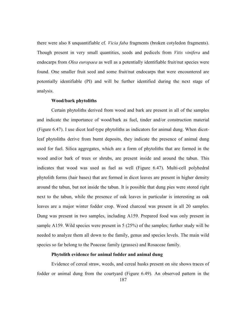
187
there were also 8 unquantifiable cf. Vicia faba fragments (broken cotyledon fragments).
Though present in very small quantities, seeds and pedicels from Vitis vinifera and
endocarps from Olea europaea as well as a potentially identifiable fruit/nut species were
found. One smaller fruit seed and some fruit/nut endocarps that were encountered are
potentially identifiable (PI) and will be further identified during the next stage of
analysis.
Wood/bark phytoliths
Certain phytoliths derived from wood and bark are present in all of the samples
and indicate the importance of wood/bark as fuel, tinder and/or construction material
(Figure 6.47). I use dicot leaf-type phytoliths as indicators for animal dung. When dicot-
leaf phytoliths derive from burnt deposits, they indicate the presence of animal dung
used for fuel. Silica aggregates, which are a form of phytoliths that are formed in the
wood and/or bark of trees or shrubs, are present inside and around the tabun. This
indicates that wood was used as fuel as well (Figure 6.47). Multi-cell polyhedral
phytolith forms (hair bases) that are formed in dicot leaves are present in higher density
around the tabun, but not inside the tabun. It is possible that dung pies were stored right
next to the tabun, while the presence of oak leaves in particular is interesting as oak
leaves are a major winter fodder crop. Wood charcoal was present in all 20 samples.
Dung was present in two samples, including A159. Prepared food was only present in
sample A159. Wild species were present in 5 (25%) of the samples; further study will be
needed to analyze them all down to the family, genus and species levels. The main wild
species so far belong to the Poaceae family (grasses) and Rosaceae family.
Phytolith evidence for animal fodder and animal dung
Evidence of cereal straw, weeds, and cereal husks present on site shows traces of
fodder or animal dung from the courtyard (Figure 6.49). An observed pattern in the
188
phytolith assemblage is the concentration of cereal straw, wild grass husk and sedge
phytoliths in higher densities and includes samples from the area around and inside the
tabun (a10 and a11; occupation phase III, unit 13) (Figure 6.49). This pattern indicates
the presence of animal dung (or fodder). The interior of the tabun ash was also analyzed
for phytoliths. The ash is rich in wood/bark phytoliths (Figure 6.47), sedges, weeds, and
leaf/stem phytoliths of grasses (Figure 6.49). Also, unidentified cereal husks and straw
are present in the tabun ash. Traces of animal dung are found in higher densities in
context a47. Phytoliths of sedges and wild grass husks are present within samples
derived from surface a47, suggesting the presence of animal fodder and/or dung in this
context.
Figure 6.52 shows a correlation coefficient between wheat and wild grass husks
(0.46), Figure 6.53 a correlation coefficient between Total Husk and wild grass husks
(0.02) and Figure 5.54 a correlation coefficient between cereal straw and wild grass
husks (0.05). Figure 6.55 shows a correlation coefficient of higher significance between
total cereal husks and cereal straw (0.96) while Figure 6.56 shows a lower correlation
between cereal straw and wheat husks (0.19). Cereal straw was present in most samples
from all three occupation phases. Based on the non significant (0.5) between straw and
weeds, straw was not stored on site as fodder only but as a clean crop-processing by-
product. I expect that it was brought to the site as an early-stage crop-processing by-
product from threshing, based on the higher correlation between straw/cereals husks and
straw/wheat husk.
The inhabitants at Beidha seem to have cultivated their own cereal crops possibly
via irrigation, as the presence of large multi-cell cereal husk and straw phytoliths
indicates that they had access to primary crop-processing by-products. This suggests an
agricultural investment in this drier, marginal area of Jordan throughout the middle–late
189
Islamic periods. This could be done through runoff irrigation and the use of cisterns and
could be a sustainable method of production of cereals for local subsistence farmers.
It is apparent that the inhabitants of Beidha produced a surplus of cereal by-
products such as chaff and straw, and phytolith analysis showed that straw phytoliths
were irrigated too. There are two scenarios based on this evidence. Of course, the cereal
produce was sustaining the population of Beidha as a main food source. However, the
production of a surplus of cereal processing by-products such as chaff and straw were of
primary importance for pottery making i.e. coarse ware group pottery, for which the
chaff and straw were needed as primary fabric inclusions. The presence of large multi-
cell straw phytoliths found across the courtyard area, indicate that straw was possibly
used as a building material for the floor surface. For the inhabitants of Beidha cereal
production and surplus production of cereal by-products were of major economic value.
Finally, Figure 6.51 shows the average numbers per gram sediment of reed
phytoliths. Reeds produce keystone-shaped, single-cell phytoliths, as well as multi-cell
bulliform phytoliths. The phytolith evidence indicates the abundance of reed phytoliths
in the site's vicinity, and the important role of plants from wetland areas for the
inhabitants of Beidha. They are found in higher density in samples that derived from
contexts a47 and from the tabun area. The latter can indicate that reeds were used as fuel.
Also, reed phytoliths are found in high density within the post-holes and this could
indicate that reeds were used as construction material.

190
Figure 6.42 Total phytolith counts- average numbers per gram sediment
0
50000
100000
150000
200000
250000
300000
350000
400000
450000
500000
a25
.10
a25
a25
.1
a25
.3
a25
.5
a25
.7
a38
.1
a38
.4
a38
.7
a13
.2b
a13
.4b
a13
2b
a13
.7b
a13
.9b
a13
.10
b
a13
.12
b
a47
.1
a47
.3
a47
.5
a47
.6
a47
.6
a47
.5
a14
7
a14
7
a14
7
a14
8
a82
.2
a11
a10
a10
a10
99
mid
2
a99
.1
top
fill
96
a10
4
a10
4 t
op
a10
1
a10
1
a10
6
a82
.1
a12
4.3
n/g
ram
se
dim
en
t
Contexts
Total phytolith counts
Total phytolith counts

191
Figure 6.43 Pooid, Panicoid and Chloridoid grass single-cell phytoliths- average numbers per gram sediment
0
2000
4000
6000
8000
10000
12000
14000
16000
18000
20000
a25
.10
a25
a25
.1
a25
.3
a25
.5
a25
.7
a38
.1
a38
.4
a38
.7
a13
.2b
a13
.4b
a13
2b
a13
.7b
a13
.9b
a13
.10
b
a13
.12
b
a47
.1
a47
.3
a47
.5
a47
.6
a47
.6
a47
.5
a14
7
a14
7
a14
7
a14
8
a82
.2
a11
a10
a10
a10
99
mid
2
a99
.1
top
fill
96
a10
4
a10
4 t
op
a10
1
a10
1
a10
6
a82
.1
a12
4.3
n/g
m s
ed
ime
nt
Context
Grass short cells
Rondel. Saddle Bilobe

192
Figure 6.44 Wheat and barley husk phytoliths- average numbers per gram sediment
0
10
20
30
40
50
60
70
80
90
100
a25
.10
a25
a25
.1
a25
.3
a25
.5
a25
.7
a38
.1
a38
.4
a38
.7
a13
.2b
a13
.4b
a13
2b
a13
.7b
a13
.9b
a13
.10
b
a13
.12
b
a47
.1
a47
.3
a47
.5
a47
.6
a47
.6
a47
.5
a14
7
a14
7
a14
7
a14
8
a82
.2
a11
a10
a10
a10
99
mid
2
a99
.1
top
fill
96
a10
4
a10
4 t
op
a10
1
a10
1
a10
6
a82
.1
a12
4.3
n/g
ram
se
dim
en
t
Contexts
Grass husk phytoliths
Wheat Husk Barley Husk
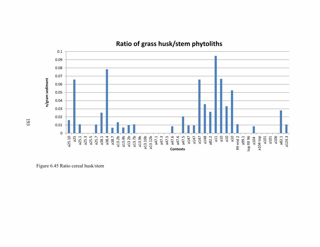
193
Figure 6.45 Ratio cereal husk/stem
0
0.01
0.02
0.03
0.04
0.05
0.06
0.07
0.08
0.09
0.1
a25
.10
a25
a25
.1
a25
.3
a25
.5
a25
.7
a38
.1
a38
.4
a38
.7
a13
.2b
a13
.4b
a13
2b
a13
.7b
a13
.9b
a13
.10
b
a13
.12
b
a47
.1
a47
.3
a47
.5
a47
.6
a47
.6
a47
.5
a14
7
a14
7
a14
7
a14
8
a82
.2
a11
a10
a10
a10
99
mid
2
a99
.1
top
fill
96
a10
4
a10
4 t
op
a10
1
a10
1
a10
6
a82
.1
a12
4.3
n/g
ram
se
dim
en
t
Contexts
Ratio of grass husk/stem phytoliths

194
Figure 6.46 Unidentified husk, wheat husk and cereal straw phytoliths of more than 10 conjoined cells - average numbers per
gram sediment
0
20
40
60
80
100
120
140
a25
.10
a25
a25
.1
a25
.3
a25
.5
a25
.7
a38
.1
a38
.4
a38
.7
a13
.2b
a13
.4b
a13
2b
a13
.7b
a13
.9b
a13
.10
b
a13
.12
b
a47
.1
a47
.3
a47
.5
a47
.6
a47
.6
a47
.5
a14
7
a14
7
a14
7
a14
8
a82
.2
a11
a10
a10
a10
99
mid
2
a99
.1
top
fill
96
a10
4
a10
4 t
op
a10
1
a10
1
a10
6
a82
.1
a12
4.3
n/g
ram
se
dim
en
t
Contexts
Grass husk phytoliths
Unident Husk >10 Wheat Husk >10 Cereal Straw >10

195
Figure 6.47 Wood/bark and shrub phytoliths- average numbers per gram sediment
365859 3904149 19311 37584 13600 0
1000
2000
3000
4000
5000
6000
7000
8000
9000
10000
a25
.10
a25
a25
.1
a25
.3
a25
.5
a25
.7
a38
.1
a38
.4
a38
.7
a13
.2b
a13
.4b
a13
2b
a13
.7b
a13
.9b
a13
.10
b
a13
.12
b
a47
.1
a47
.3
a47
.5
a47
.6
a47
.6
a47
.5
a14
7
a14
7
a14
7
a14
8
a82
.2
a11
a10
a10
a10
99
mid
2
a99
.1
top
fill
96
a10
4
a10
4 t
op
a10
1
a10
1
a10
6
a82
.1
a12
4.3
n/g
ram
se
dim
en
t
Contexts
Dicot phytoliths
Wood/Bark single-cell Dicot leaf

196
Figure 6.48 Wheat and weed husk phytoliths- average numbers per gram sediment
0
50
100
150
200
250
300
350
400
a25
.10
a25
a25
.1
a25
.3
a25
.5
a25
.7
a38
.1
a38
.4
a38
.7
a13
.2b
a13
.4b
a13
2b
a13
.7b
a13
.9b
a13
.10
b
a13
.12
b
a47
.1
a47
.3
a47
.5
a47
.6
a47
.6
a47
.5
a14
7
a14
7
a14
7
a14
8
a82
.2
a11
a10
a10
a10
99
mid
2
a99
.1
top
fill
96
a10
4
a10
4 t
op
a10
1
a10
1
a10
6
a82
.1
a12
4.3
n/g
ram
se
dim
en
t
Contexts
Grass husk phytoliths
Wheat Husk Wild Grass Husks
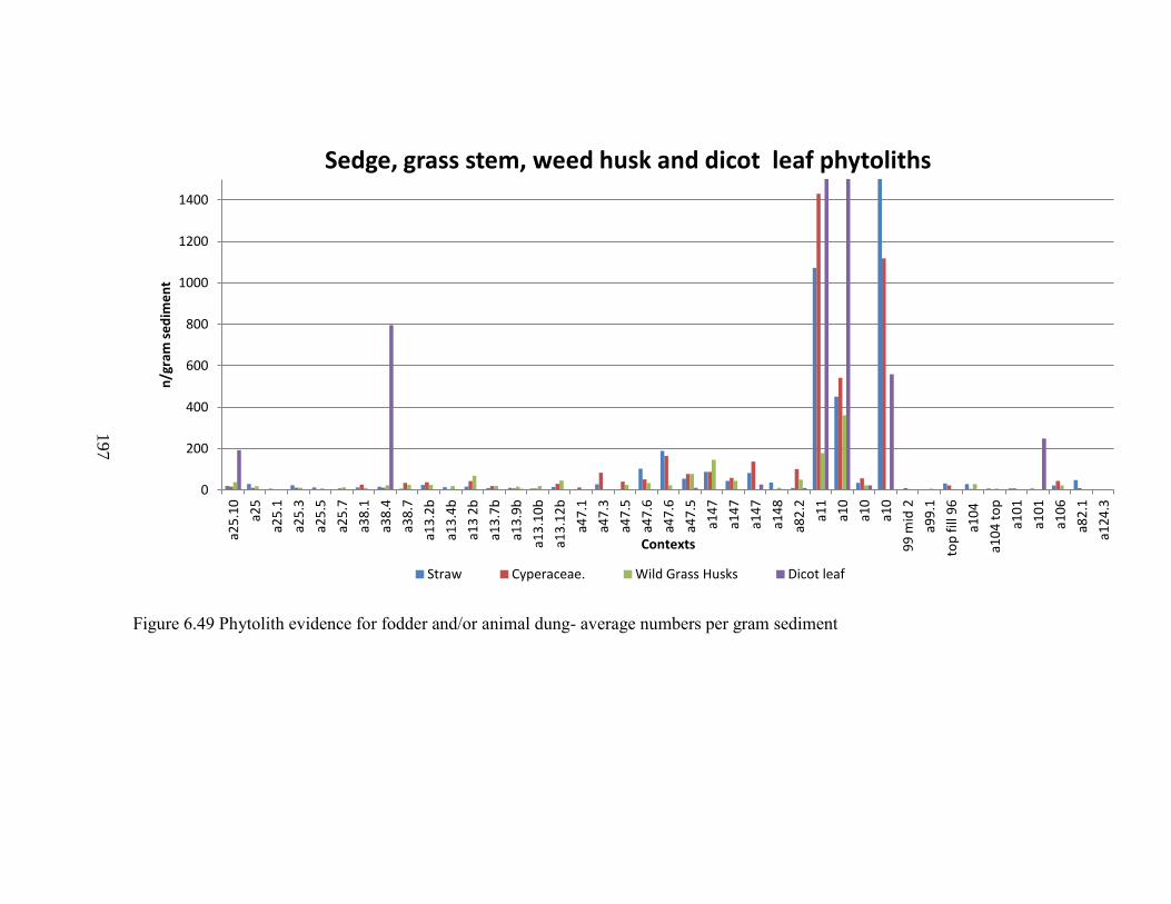
197
Figure 6.49 Phytolith evidence for fodder and/or animal dung- average numbers per gram sediment
0
200
400
600
800
1000
1200
1400
a25
.10
a25
a25
.1
a25
.3
a25
.5
a25
.7
a38
.1
a38
.4
a38
.7
a13
.2b
a13
.4b
a13
2b
a13
.7b
a13
.9b
a13
.10
b
a13
.12
b
a47
.1
a47
.3
a47
.5
a47
.6
a47
.6
a47
.5
a14
7
a14
7
a14
7
a14
8
a82
.2
a11
a10
a10
a10
99
mid
2
a99
.1
top
fill
96
a10
4
a10
4 t
op
a10
1
a10
1
a10
6
a82
.1
a12
4.3
n/g
ram
se
dim
en
t
Contexts
Sedge, grass stem, weed husk and dicot leaf phytoliths
Straw Cyperaceae. Wild Grass Husks Dicot leaf

198
Figure 6.50 Palm phytoliths- average numbers per gram sediment
0
100
200
300
400
500
600
700
800
900
1000
a25
.10
a25
a25
.1
a25
.3
a25
.5
a25
.7
a38
.1
a38
.4
a38
.7
a13
.2b
a13
.4b
a13
2b
a13
.7b
a13
.9b
a13
.10
b
a13
.12
b
a47
.1
a47
.3
a47
.5
a47
.6
a47
.6
a47
.5
a14
7
a14
7
a14
7
a14
8
a82
.2
a11
a10
a10
a10
99
mid
2
a99
.1
top
fill
96
a10
4
a10
4 t
op
a10
1
a10
1
a10
6
a82
.1
a12
4.3
n/g
ram
se
dim
en
t
Contexts
Echinate Spheroid (cf. palm)
Echinate Spheroid (cf. palm)

199
Figure 6.51 Reed phytoliths- average numbers per gram sediment
0
200
400
600
800
1000
1200
1400
1600
1800
2000
a25
.10
a25
a25
.1
a25
.3
a25
.5
a25
.7
a38
.1
a38
.4
a38
.7
a13
.2b
a13
.4b
a13
2b
a13
.7b
a13
.9b
a13
.10
b
a13
.12
b
a47
.1
a47
.3
a47
.5
a47
.6
a47
.6
a47
.5
a14
7
a14
7
a14
7
a14
8
a82
.2
a11
a10
a10
a10
99
mid
2
a99
.1
top
fill
96
a10
4
a10
4 t
op
a10
1
a10
1
a10
6
a82
.1
a12
4.3
n/g
m s
ed
ime
nt
Contexts
Reed phytoliths
Keystone Leaf/stem bulliform (cf. reed grass)

200
R² = 0.0469
0
100
200
300
400
500
600
700
800
900
0 50 100 150 200 250 300 350 400
Wheat/Weed
Series1
Linear (Series1)
Figure 6.52 Correlation coefficient of wheat vs. weed
R² = 0.0205
0
100
200
300
400
500
600
700
800
900
0 500 1000 1500 2000 2500 3000
Total Husk/Weed
Series1
Linear (Series1)
Figure 6.53 Correlation coefficient of cereal husk vs. weed

201
R² = 0.0501
0
100
200
300
400
500
600
700
800
900
0 500 1000 1500 2000 2500
Straw/Weed
Series1
Linear (Series1)
Figure 6.54 Correlation coefficient of straw vs. weed
R² = 0.9651
-500
0
500
1000
1500
2000
2500
3000
3500
0 500 1000 1500 2000 2500
Straw/Total Husk
Series1
Linear (Series1)
Figure 6.55 Correlation coefficient of straw vs. husk

202
Figure 6.56 Correlation coefficient of straw vs. wheat
R² = 0.1941
0
50
100
150
200
250
300
350
400
0 500 1000 1500 2000 2500
Straw/Wheat
Series1
Linear (Series1)

203
Chapter 7: Discussion
In this chapter, I review the phytolith data presented in chapter 6, and I
demonstrate the ways that phytolith and environmental analyses contributed to our
understandings of medieval Islamic intensified agriculture and the ways early pre-
industrial and agricultural activities impacted semi-arid landscapes and small-scale
communities in Transjordan.
INTENSIFIED AGRICULTURAL PRODUCTION OF CASH CROPS IN MEDIEVAL
TRANSJORDAN
The local, heavy investment in and intensification of the production of grain in
Transjordan, that was driven by medieval commercial and international trade networks
(Abu-Lughod, 1991, Watson, 1983), was reflected in the phytolith record derived from
Tell Hisban (Figure 6.13). Diagnostic multi-cell phytoliths of wheat and barley husks,
derived from the Governor's storeroom within the Citadel suggested that hulled wheat
was brought to the site and stored in storerooms in the husk (Figures 6.14, 6.15 and 6.16).
Also, evidence for irrigated cereals showed that irrigated crops were present in higher
densities in the Governor's storeroom (Field L) and midden (Field M1) at Tell Hisban and
not in the domestic contexts in the medieval village (Figure 6.27). Large multi-cell cereal
phytoliths indicated growing conditions on wetlands and irrigation. The phytolith
evidence for the production, storage and management of irrigated grains were a marker of
continuous intensified production of grain surplus under the Mamluk rule in the region of
Tell Hisban.
The phytolith record indicated that there was a shift from subsistence farming for
local markets to surplus production of cereal grain for export, during the Mamluk rule in
the area of Tell Hisban. According to the phytolith evidence, the state produced irrigated
grain during years of plenty (Figure 6.27) and controlled grain surplus to be used in times
204
of need in medieval Transjordan. Historic documents indicated that the surplus was
exploited by the state through forced purchases (Walker, 2008, Walker, 2009). Wheat and
barley from al-Balqa was exported in times of need, and the grain fields of Transjordan
were some of the most reliable iqta'a of Bilad ash-Sham (Walker, 2009).
Wheat production at Tell Hisban was local, as suggested by the presence of chaff
versus its absence, which might indicate a supply of clean grain from elsewhere (Figures
6.16, 6.23, 6.24). Cereals were produced for human consumption at the Citadel, as
indicated by the presence of wheat husk silica skeletons in the hearth within the
Governor's residence (Figure 6.15), and the midden (Field M1) (Figure 6.23 and 6.27),
but they were also used for the production of early stage by-products such as grass husks
and cereal straw. Concentrations of fodder and/or dung indicators in the courtyard of the
Governor's residence (Jones, 1984, Hillman, 1981) indicated that animals were foddered
and kept in that space, and fodder was stored in that space.
The phytolith record from Tell Hisban indicated that wheat was the major cash
crop at the site in the Mamluk period and the most common and important staple crop at
Tell Hisban (Figure 6.15, 6.23. 6.27). The Mamluk state and the inhabitants of Tell
Hisban exploited the fields on the Madaba Plateau for the production of cereal crops and
grain surplus. Also, it appears from the phytolith records that local state officials
depended on the storage and management of the agricultural surplus, but also on the
production and management of the surplus of agricultural crop by-products such as
fodder. These were valuable commodities that would sustain livestock for meat
consumption at a subsistence level in the Citadel, for the production of animal by-
products and for the storage of animal dung used for fuel and manure (Figure 6.16).
Phytolith evidence for animal dung used for fuel derived from the hearth context inside
the Governor's residence (Figure 6.11, 6.14, 6.15, 6.16, 6.17--see chapter 6). Phytolith

205
evidence for the storage of animal fodder and penning of livestock derived from the
Governor’s courtyard (Field Q5) (Figure 6.16).
Phytolith data for the intensified production of wheat and barley in this region
suggested the practice of extensive plowing and the potential interruption of the fallow
periods during imperial agricultural regimes. Tell Hisban is located in a marginal area for
crop production where the average annual rainfall ranges between 300-400 mm in the
northwest, and is below 200 mm in the south (Cordova et al., 2005, Cordova, 2007). The
phytolith evidence indicated intensified production of grains, via irrigation, that might
have led to a degraded environment after centuries of grain production for profit and
surplus and would have accelerated the effects of extreme weather events on the
landscape, such as floods. Walker (2011) wrote about the chronicle of Ibn Hijji10. Ibn
Hijji recorded a big rain that took place in 1388, and mentioned that this event prevented
people from travelling from and to his hometown, Tell Hisban (Walker 2011: 73). In
addition, Walker (2011,: 73) made reference to the chronicle of Ibn Qadi Shuhbah11 (d.
1448). Ibn Qadi Shuhbah wrote that in the year 1385, a flood took place near Hisban and
destroyed 18 gardens and 12,000 walnut trees and in the year 1401, he witnessed "giant
hail the size of walnuts and eggs..." (Walker 2011: 73). Also, periods of reduced rainfall
would have led to crop failures during the Mamluk periods, in the area of Hisban on the
Madaba Plains. The local state officials and the villagers would have had dependable
agricultural production, either rain-fed or with the use of irrigation. They could have
relied on a series of successful years of adequate rainfall for wheat production. But, in the
case of unpredictable anomalies during years of inadequate rains, and after extended
10 Ibn Hijji al-Hisbani (1350-1413), a Damascus-born scholar, was originally from Hisban and is the author
of Syrian chronicles that offer insider information on the Jordanian society and particularly on Tell Hisban
(Walker 2011: 18). 11 Ibn Qadi Shuhbah, was born and raised in Damascus and was a student of Ibn Hijji.

206
droughts, the farmers and the state, according to the phytolith records, depended on the
production, storage and control of the agricultural surplus of cereals, and crop by-
products of economic value, such as chaff and fodder (Van der Veen, 1999, Walker,
2009).
Intensive forms of cultivation are required for the production of agricultural
surplus in semi-arid areas. These include processes such as the digging of canals,
plowing, animal grazing and manuring of fields, that all took place during the
implementation of the iqta' system. We do not know whether the lands of Hisban
constituted an iqta’ although this is highly likely (Walker, 2011), knowing that on the
Madaba Plains Dhiban lands were iqta'a in 1261 AD (Walker, 2009). In medieval fields
on the Madaba Plateau those building activities would be necessary for the production of
grain surplus and the surplus of cereal by-products. The building activities that related to
agriculture, such as digging canals and dams, relied on the muqta'a and the labor of
peasants and soldiers (Walker, 2008).
The intensive cultivation suggested by the phytolith data, would enhance
devegetation and erosion on semi-arid landscapes, especially after periods of intensified
cultivation via irrigation and the abandonment of those building activities (Cordova,
2000, Cordova, 2008). The area of Tell Hisban and the broader area of the Madaba-
Dhiban Plateaus, were influenced by the large scale investment in the production of
cereal grain and the establishment of Tell Hisban as the capital of al-Balqa. However,
after the transfer of the capital of al-Balqa from Tell Hisban to Amman in 1356 AD, state
investment and monitoring of those building activities and the preparation of fields for
sowing and harvest would have been less controlled. During periods of extreme weather
events such as floods, it would have been more difficult for the villagers of Tell Hisban to
maintain the earthworks created for large-scale production of cereal cash-crops.

207
The phytolith evidence of dung for fuel or manure may indicate an environment
under stress due to imperial intensified agricultural production. The phytolith record as
depicted in the phytolith results picked up the presence of dung, possibly used as
fertilizer (Figures 6.16, 6.17). Prolonged periods of intensified cultivation in the
agricultural fields of Tell Hisban would generate areas of very low fertility. Manuring
with the use of animal dung is the most productive soil fertilizer, which can improve crop
yields for up to ten years (Palmer, 1998). This would have had affected subsistence
farmers as well. Subsistence level farmers, during periods of loose support may not have
been able to invest in large-scale fertilizers such as manure to support the recovery of the
soil, especially for periods with a lesser state investment in local agriculture. Livestock
would have provided the farmers with animal dung which has an important role in the
household economy (Valamoti and Charles, 2005, Palmer, 2002, Palmer, 1996). Fodder
and animal dung are of great economic value for settlers of dry regions, for
manufacturing dung cakes used as fuel for bread ovens or as manure (Charles 1998,
Hillman et al. 1997, Miller 1984, Miller and Smart 1984, Valamoti and Charles 2005,
Van der Veen, 1999). However, large -scale imperial agricultural regimes would generate
larger demands for manure.
In addition to the large-scale grain production and trade, sugarcane grown in the
Jordan Valley during the 13th and 14th centuries (Walker, 2011) supported the long-
distance medieval trade networks (Abu-Lughod, 1991, Jum'a Mahmoud, 2000). A major
aspect of the medieval imperial agricultural economy of Transjordan was the production
and long-distance trade of sugarcane (BURKE, 2004, Jones et al., 2002, Taha, 2009,
Tsugitaka, 2004).
Overall, phytolith analysis from Tawahin as-Sukkar, offered direct evidence for
the cultivation of sugarcane and the use of cane for the fuel required for the processing

208
and refining of the exotic crop. Data derived from the pile of industrial waste next to the
factory at Tawahin as-Sukkar, pointed to the continuous use of wood for fuel for the
century in which the factory was in use (Figure 6.41) (Bozaarth, 1992).Thus, the
processing and refining of sugarcane exploited trees and/or shrubs available in the region
for fuel (Figure 6.41). In addition, phytolith data showed that alternative sources of fuel
were the leaves and other parts of palms (Phoenix dactylifera) and the stalks of sugarcane
(Figure 6.41). Perhaps palms and sugarcane were preferred as alternative sources of fuel,
when dicot leaves and/or wood and bark were not available. Also, other reed grasses
could be a source for fuel (Figure 6.41) but the main source of fuel used came from dicot
plants.
These phytolith data suggested that the state invested in the cultivation of
sugarcane for profit in the lands around Tawahin as-Sukkar. The plantations in the Jordan
Valley (Ghor) provided the state with revenues from the sale of sugarcane to buyers, and
the revenues supported education in Cairo (Walker 2009, Walker, 2008). On sugar
estates, the cultivation of sugarcane replaced the production of other crops, as well as
customary water sharing agreements (Walker 2011). The production of the exotic crop
interrupted traditional crop rotation regimes. One can envision how the sugar plantations
that were established for almost a century in Ghor as-Safi, impacted the environment.
The cultivation of the exotic crop in the region would favor de-vegetation, and the
creation of secondary vegetation, and lead to a decline in the regional diversity of
vegetation.
MEDIEVAL PEASANT ECONOMIES DURING PERIODS OF INTENSIFIED AGRICULTURE
In the case of Mamluk Jordan, the direct impact of the implementation of the iqta’
system was that the medieval peasant became landless and was much more restricted to

209
traditional agricultural regimes under the pressure for increased annual yields for the
muqta'a (see Chapters 2 and 4). The true buffers for the environment and the peasants, a
moral traditional agricultural economy and a system of risk minimization strategies, were
taken away from peasant communities under the new cash crop economy. According to
phytolith evidence for the intensified production of grains and sugarcane, the Mamluk
state economic interests contrasted with the Jordanian peasant sustainable systems in
central and south Jordan. State intensified agricultural production must have led to a
pronounced impact on the environment due to imperial and soil exhausting agricultural
regimes.
However, phytolith evidence derived from medieval rural sites of Transjordan
such as, Jerash, Tell Hisban, Shuqayra and Beidha, showed that peasants invested in
mixed agro-pastoral economies; the distribution of agricultural surplus to local markets;
and small-scale production and storage of cereals, other crops, and agricultural surplus.
Also, peasants relied on livestock and crop by-products, such as chaff and fodder. They
depended on their autonomy to invest in strategies of adaptation that minimize risk
(Halstead, 1990; Halstead and Jones, 1989).
According to the phytolith records, cereal production at the village-level,
particularly wheat, was important in the central and southern regions of Transjordan such
as the Madaba and Karak Plateaus. Phytolith evidence derived from the farmhouses in the
village of Tell Hisban, and the room floors in the rural town of Shuqayra, indicated that
cereal production and management of agricultural surplus, cereal by-products and
livestock, played an important role in household economy (Figures 6.32 and 6.33). Also,
the phytolith records derived from both sites, based on crop-processing indicators,
suggested that grain production was local in Shuqayra and Tell Hisban (Figure 6.16,
6..25, 6.26, 6.33).

210
Tell Hisban was the capital of al-Balqa from AD 1309 to 1356, but in 1350 the
administrative center was moved to Amman (Walker, 2003). The peasants most probably
had a shelter of state support during the mid-13th and early 14th centuries but after the
year 1350, they may have not enjoyed the support of the state to deal with the areas with
dry-depleted soils that Mamluk imperial agriculture bequeathed to them. If the local
community at Tell Hisban during the 14th and 15th centuries may have faced the
challenge of areas of depleted soils, which had lost their capacity to retain moisture and
flooded in the heavy rains after extended periods of drought so would the community at
Shuqayra al-Gharbiyya (Walker 2011: 73).
Phytolith indicators of diversified agriculture suggested a more sustainable and
resilient agricultural economy at a village-level, at Tell Hisban and Shuqayra al-
Gharbiyya, during the Mamluk plantation economy. Diversification, namely a variety of
crops produced and livestock kept, was used as a low-level mechanism against crop
failure and food shortage. The botanical data picked up signals for the use of a variety of
crops and the reliance on livestock at a household level.
Macro-botanical evidence derived from Tell Hisban and Shuqayra, showed that
the inhabitants relied on mixed cropping, growing a range of cereal crops as well as
summer crops, fruits, vegetables, and pulses (data analyzed by Annette Hansen-
archaeobotanist). The phytolith record from Tell Hisban, derived from the farmstead
(Field O9), revealed that peasants had access to wheat and barley crops. Wheat and
barley husk phytoliths were present in high densities in the midden found inside the
single-room farmhouse (Figures 6.22, 6.27). Also, high densities of identified wheat and
barley husks and lower relative absolute counts of wild grass husks inside the barrel-
vaulted structure (Field M8), indicated the deposition, processing and/or storage of clean
cereal crop in this context (Figure 6.24). The phytolith records picked up the use and

211
storage of date palms too, which were present in sediment samples derived from the
farmhouse (Field O9), and from the Citadel showing that dates (Phoenix dactylifera)
formed a basic role in the economy of Tell Hisban (Figure 6.28). The date palms were
produced in the Jordan Valley and imported to Tell Hisban. Also, the phytolith data
derived from three Mamluk occupation surfaces at Shuqayra al-Gharbiyya, dating to the
14th
century showed that cereal production was important for the village economy of
Shuqayra. Local community depended on the production of wheat, the most common and
important crop (Figure 6.32 and 6.33), and crop-processing indicators suggest early
processing stages in all samples acquired from the three occupation floors. This shows
that wheat production was local (Figure, 6.33).
In the case of Tell Hisban, judging from the presence of larger amounts of wheat
husk phytoliths in the storage room (Filed L) inside the Citadel (see previous section), I
suggested that the management of stored food and the large-scale storage of wheat was
eventually controlled. The distribution of irrigated cereal crop was managed and
controlled by the local Governor. However, phytolith results derived from the farmhouse
(Field O9) showed that control of irrigable land by subsistence farmers gave them
resilience and contributed to sustainable farming. The presence of large multi-cell straw,
wild grass husk, and cereal husk phytoliths in the household middens, indicates that the
peasants had access to primary crop-processing by-products and also indicates that
cereals were locally produced (Figure 6.27). The phytolith data picked up signals for the
storage of irrigated crop and cereal surplus at a household level too.
Also, peasants at Tell Hisban relied on livestock for animal dung and animal by-
products, which had an important role in the household economy. The presence of crop-
processing by-products, fodder and/or dung, such as cereal husks, cereal straw, wild grass
husks, and dicot leaf phytoliths was shown in the phytolith records from the medieval

212
farmhouse (Field O9) (Figure 6.26). The phytolith record picked up the presence of dung
that could have been possibly used as fertilizer (Figures 6.16, 6.17, 6.26). High densities
of straw, wheat, barley, and weeds in the samples derived from the hearth could imply
that animal dung may have been used for fuel too (Figures 6.16, 6.17, 6.26) (Charles,
1996; Hillman, 1981; Tsartsidou et al., 2007; Van der Veen, 1999).
Peasant communities that live in marginal areas for crop production rely on the
production and management of crop surplus in order to cope with droughts during bad
years (Rosen 2007:141). They rely on the management of some crop surplus and crop by-
products and the distribution of such commodities to local markets. In this way they
convert perishable products and foodstuffs into nonperishable materials which could be
exchanged for food during bad years (Rosen 2007: 141, Halstead 1990). The phytolith
evidence from the medieval village at Tell Hisban indicated the production and storage of
the surplus of agricultural by-products such as cereal chaff and straw, and showed
evidence for the exploitation of domestic livestock. The peasants of Tell Hisban had
access to cereal straw and crop-processing by-products (Figure 6.26), used as fodder in
order to sustain domestic livestock. Also, the phytolith records form the Early Islamic
market at Jerash provided evidence for the distribution of such surpluses to local markets
by medieval peasants. Jerash was a town of commercial and economic significance for
the early Islamic periods (7th-12th centuries) and was formed under the Umayyad rule
with the addition of market streets. The phytolith record from Jerash provided secure and
informative contexts for evidence of local Islamic agricultural produce.
The phytolith record from the two shops at the Early Islamic market at Jerash,
showed that farmers buffered against crop failure through the distribution to the market
of cereal products and by-products. The phytolith evidence suggested that farmers
produced a surplus of cereal crop, in the hinterland of Jerash, and also they produced and

213
managed a surplus of fodder to sustain their animals. Farmers distributed their surplus to
the market in exchange for money (Rosen, 2007). The two main cereal crops, wheat and
barley (Figure 6.2), were cultivated in the hinterland of Jerash (Figure 6.3, 6.4, 6.5), and
agriculture was rain-fed according to phytolith evidence for non irrigated cereal-crops.
Also, farmers from the Jordan Valley distributed date palm to the market of Jerash. The
production of surplus, including grain and fodder (Figures 6.3, 6.4, 6.5), was of great
economic value for the local market economy and was counted as a substitute for cash for
the subsistence farmers during bad years.
The phytolith analysis on samples derived from the medieval village at Beidha, in
southern Transjordan showed that the local peasant community sustained a subsistence
agricultural economy, primarily based on cereal production (Figure 6.44 and 6.46).
Phytoliths indicated that peasants at Beidha employed adaptive economic strategies to
cope with agricultural uncertainty, in the absence of local state-level support and during
bad years of inadequate rainfall. Those strategies were: the reliance on domestic livestock
and animal by-products; the investment in animal dung; the intensified production of
cereals and cereal surplus; and the possible exchange of the surplus of crop by-products
in times of need (see discussion below).
In the southern regions of Transjordan, from the Crusader periods and through the
end of the Mamluk period, villagers expanded into fragile marginal ecological settings at
Beidha and established a flourishing agricultural community. According to Bikai (2006),
houses at the medieval Islamic village at Beidha were established during the Crusader
period to accommodate agricultural workers. Phytoliths and macro-botanical analysis
suggested that agricultural communities in Beidha intensified the agriculture of cereals in
this marginal area, and invested in small-scale diversified agro-pastoral economy (Figure
6.44).

214
The inhabitants at Beidha cultivated their own crops via irrigation, as the presence
of large multi-cell straw phytoliths indicated (Figure 6.46), and they had access to
primary cereal crop-processing by-products (Figure 6.49). The main cereal crops
identified in the samples analyzed from the medieval village at Beidha were wheat and
barley (Figure 6.44). This could have been possible through runoff irrigation and through
the use of cisterns. The phytolith record showed that wheat and barley were both major
economic crops in medieval Beidha. The presence of wheat and barley crop-processing
by-products such as chaff and straw (Figures 6.46 and 6.49) suggested that both crops
were cultivated near the site for local subsistence. Wheat husk phytoliths were found in
higher densities in sample a11 (soil around the tabun), an area associated with cooking
activities, and most probably the preparation of bread (occupation phase III).
Wheat husk phytoliths were abundant in the samples associated with what was
identified as a storage area, within Spatial Unit 3-household (contexts a147 and a148,
Figure 6.44, 6.46). The presence of wheat and barley husk phytoliths most probably
indicated that some grain was stored in Unit 3. Also, the phytolith record showed that
some date palm (Phoenix dactylifera) phytoliths were also present in large amounts in the
interior of the storage vessel in Unit 3 (Figure 6.50). This showed that storage of grain
and/or date palm elements played an important role in local economy and was an
agricultural risk buffering mechanism adopted by local peasants.
Also, it appears through the phytolith record that straw was a valuable commodity
that local peasants relied on in order to sustain their animals. Higher densities of multi-
cell phytoliths that form in irrigated cereal straw were found in context A47 (Figure
6.46). Evidence of straw, weeds, and husks present on site showed traces of fodder or
dung from the courtyard (Figure 6.49). The peasants at Beidha profited from an agro-
pastoral economy and buffered themselves against the uncertainty of local low crop yield

215
in this marginal area for crop production, during the dry years of the three occupation
phases in this region of absent state control. Because wheat-husk phytoliths were also
present in contexts throughout the courtyard it is possible that certain areas, during
occupation Phases I - III, were associated with the grinding/processing of grain (wheat).
The presence of wheat husks are interpreted as early-stage crop-processing by-products,
based on the presence of free-threshing wheat (Triticum aestivum/durum) in the macro-
botanical data12. Cereal straw and wild grass husks found throughout the courtyard,
further suggested crop processing and/or grain and fodder storage. Furthermore, higher
densities of sedges and wild grass husks suggested the presence of animal fodder and/or
dung in context A47. So animals were kept and fed at times in this space (Figure 6.49).
In Beidha, an area which receives much lower precipitation compared to the
Madaba Plains and the Karak Plateaus, and which has soils that are not clay rich and do
not retain moisture, such an intensified investment in agriculture would have had
devastating effects on the community and the environment. In this way, the state
agricultural economy from the Crusader period and during looser state control in the
Mamluk periods in the late 14th and 15th century, must have affected the local
environment of Beidha through its exploitation for cereal cultivation and animal grazing.
Traces of animal dung were found in higher densities in the soil around and inside
the tabun (a10 and a11; occupation phase III, unit 13). Multi-cell phytolith forms found in
polyhedral hair bases from dicot leaves, were present in larger amounts around the tabun,
rather than inside the tabun ash. The presence of dicot leaves and particularly oak leaves
in this assemblage, makes the interpretation more complicated as oak is a major winter
fodder crop. Most probably, dung cakes were stored right next to the tabun and animal
12 Analyzed by Annette Hansen (archaeobotanishs, University of Groningen)

216
dung was also used to maintain the domestic oven (Palmer 1998). The presence of
sedges, which are major forage crops, weeds and irrigated cereal straw in those contexts
strengthened this scenario further. It is obvious from the phytolith record that animals
were kept on site and their dung was of an economic value for local peasants, and was
used for fuel and/or fertilizer. Silica aggregates, which are a form of phytoliths that derive
from wood and/or the bark of trees or shrubs were present inside and around the tabun.
As expected wood was used as fuel too (Figure 6.47).
Cereal straw was present in most samples from all three occupation phases
(Figure 6.46, 6.49). Straw was not stored on site as fodder based on the absence of a
correlation between straw and weeds. I expect that straw was brought to the site as an
early-stage crop-processing by-product from threshing, based on the significant
correlation between straw/cereals husks and straw/wheat husk (Figure 6.55, 6.56).
However, I expect that cereal straw and chaff were eventually used as fodder as well,
based on its presence in the ashy remains of the tabun. Also, animals were possibly
grazing in more distant open habitats, and pasture environments, or on the agricultural
fields.
It is apparent that the inhabitants of Beidha produced a surplus of cereal by-
products such as chaff and straw, and phytolith analysis showed that straw phytoliths
were also irrigated. There are two scenarios based on this evidence. Of course cereals
sustained the population of Beidha as a main food source. However, the production of a
surplus of cereal processing by-products such as chaff and straw were of a primary
importance for pottery-making i.e coarse ware group pottery, for which the chaff and
straw were needed as primary fabric inclusions. The presence of large multi-cell straw
phytoliths found across the courtyard area, indicated that straw was possibly used as a

217
building material for the floor surface. For the inhabitants of Beidha cereal production
and surplus production of cereal by-products were of a major economic value.
Reeds produce keystone-shaped bulliform phytoliths and were abundant in all
samples. Local community relied on wetland resources, such as reeds for the acquisition
of construction material (Figure 6.51). Also, the presence of Cyperaceae (sedge) plants,
was ubiquitous in all samples. Their presence in the samples indicate wet and moist
micro-environments around the site. Cyperaceae plants are also a forage crop and their
presence in certain contexts indicates the presence of dung.
On the other hand in the region of the southern parts of the Jordan Valley, the
samples derived from the domestic deposits of the medieval village in Khirbet ash-Sheikh
Isa, adjacent to the sugar factory offered valuable information on the impact that the
mono-cropping, sugarcane plantation economy had on the local environment and the
village farmers. Micro-botanical data from Khirbet as-Sheikh Isa provided information
on the village-level economy of the local peasant communities, who were the workers
employed at the factory.
The study of phytoliths from these deposits showed very low counts of wheat and
cereal straw, in all samples, while barley is totally absent (Figure 6.40). State-controlled
economic practices related to the sugar plantations probably did not allow for the
widespread cultivation of wheat or barley, major staples of the Mamluk period in Jordan,
or for the cultivation of plants of the Cucurbitaceae family. This community might not
have depended heavily on the agricultural production of the two main cereal crops, or
they purchased wheat for bread because they worked in the factory, not in the fields.
The phytolith data from burnt features such as the ash pit, the tabun, and burnt
deposits on the floor surface (Figure 6.40), were rich in the phytoliths of wild grasses,
sedges, and dicot leaves. Limited numbers of husks of irrigated, large multi-cell wheat

218
silica skeletons were also found in the ash pit. These data point to the extensive use of
dung for fuel in the village of Khirbet as-Sheikh Isa (Charles, 1996; Hillman, 1981;
Palmer, 1998; Van der Veen, 1999). It is likely that the inhabitants of Khirbet as-Sheikh
Isa relied on a small-scale agro-pastoral economy and depended on the cultivation of
wheat, possibly in small irrigated plots. In general, this analysis could indicate that while
the sugarcane factory was in use, sugar plantations took over the environment and altered
the ecologies of this fertile and important region for agriculture profoundly.
Sugar cultivation interrupted the traditional planting schedule in the region of
Ghor. Sugar production was closely monitored by the muqta’ and often the Sultan
himself, and often replaced other crops and customary water sharing agreements (Walker,
2011). As a result of this, local communities must have suffered a great decrease in other
resources such as wheat and barley which were the main staples at the time as well as
after state withdrawal. People would have been unprepared to adjust to the state
withdrawal during the late 14th century. It was the state that had sustained the big
agricultural and industrial sector of sugarcane for a century. The intensive cultivation of
this labor and water-demanding crop would have led to a greatly depleted environment.
219
Chapter 8: Conclusions
Phytolith analysis of sediment samples derived from urban, industrial and rural
medieval sites in Transjordan provided a new insight into Mamluk state and peasant
agricultural activities. This environmental study of medieval peasant agricultural and
pastoral practices in relation to industrialization and intensification of state agriculture,
added original and direct evidence for medieval land use to the existing historical and
archaeological projects on rural Islamic Archaeology of Jordan. In particular, this study
produced phytolith evidence for the intensification of cereal production on the Madaba-
Dhiban Plateaus, via state irrigation as well as for the intensified production and refining
of sugarcane in the southern Jordan Valley during the Mamluk period. The phytolith
evidence showed that these imperial agricultural and industrial activities were intensified
for a brief time in the Mamluk periods and must have led to a pronounced impact on the
environment of the semi-arid central plains and the southern Ghors in Jordan. The
phytolith evidence derived from the Mamluk Citadel at Tell Hisban and the sugarcane
factory at Ghor as-Safi reflected the state investment in and intensification of the
production of grain and sugarcane, respectively.
Phytolith evidence analyzed for this dissertation also showed the potential of
phytoliths for exploring not only imperial agricultural regimes but also small-scale agro-
pastoral economies in medieval Transjordan. Phytolith analyses indicated that during
periods of intensified agricultural production, peasants were able to invest in complex
autonomous agro-pastoral strategies such as mixed agro-pastoral economies, the
distribution of agricultural surplus to local markets, and small-scale production and
storage of cereals, other crops, and agricultural surplus. Using phytolith analysis I
indicated that Mamluk peasants invested in risk minimization agricultural strategies and

220
engaged in different types of labor, other than the farm labor related to the grain and
sugar plantations of the Mamluk State. Phytolith data for small-scale peasant agriculture
used in this dissertation derived from the village around the citadel at Tell Hisban, from
Shuqayra, from the village next to the sugarcane factory in Safi, Khirbet ash-Sheikh Isa,
and from the medieval village at Beidha.
Phytolith assemblages from the sugarcane factory in Ghor as-Safi indicated that
extensive production and processing of the sugarcane took place under the Mamluk rule
in Jordan for almost a century. Phytolith evidence derived from the industrial waste at the
sugarcane factory showed the use of wood/bark and sugarcane stalks for fuel. This
implied that multiple scales of deforestation and land clearance for sugarcane cultivation
were required to support the new Mamluk industry.
I showed that the influence of the state economic interests on sugarcane
production contrasted with small-scale peasant sustainable agrarian systems, and altered
the ecologies of this fertile and important region for agriculture profoundly. Sugar
cultivation is demanding in terms of water resources and the fuel which is required for
processing (Galloway, 1989). This could have led to the deforestation of state land and
consequent erosion of soil cover. The cultivation of the exotic crop in the region took
over the environment of Ghor as-Safi. Using phytolith evidence from the village near the
factory, I showed that state-controlled economic practices related to the sugar plantations
probably did not allow for the widespread cultivation of wheat or barley, which were
major staples of the Mamluk period. The botanical data derived from both the Industrial
unit and the medieval village of the wage-workers employed in the sugar industry
provided a more multi-faceted approach to the organization of Mamluk peasant
communities employed in the sugarcane industry.
221
It is known through the medieval archival records, that in the Mamluk period
although local custom prevailed in matters of crop-harvest and crop-processing, this did
not apply to the sugar estates and the large profitable iqta'at (Walker 2011). The
production of sugarcane interrupted traditional crop rotation and the planting of summer
crops (Walker 2003). The direct impact of the implementation of the iqta’ system was
that the peasants became landless and in the regions of the profitable iqta' lands they
were more restricted from practicing traditional agricultural regimes under the pressure
for increased annual yields for the muqta’a (Walker 2011). Only in private or
individually held land, the individual would have made decisions on cropping according
to markets and environmental factors (Palmer, 1998).
According to historic documentation, the new mono-cropping system did not
allow for the traditional two-crop rotation agriculture to prevail, meaning the alteration of
winter crops with summer legumes and vegetables in order to replenish soil nutrients
(Walker, 2009). However, micro-botanical data from Khirbet as-Sheikh Isa, the medieval
village adjacent to the factory, indicated that the local peasants, who were the workers
employed at the factory invested in small-scale agro-pastoral economy and depended on
the cultivation of wheat, some legumes and fruits, possibly in small irrigated plots near
the site. Peasants re-organized their village economy and depended on the small-scale
production, storage and control of the agricultural surplus of cereals, and crop by-
products of economic value, such as chaff and fodder as well as date palms. The
production and storage of grain and/or date palms played an important role in local
economies and was an agricultural risk-buffering mechanism adopted by local peasants at
Ghor as-Safi. This thesis is central to Peasant Studies Theory and the evidence from Ghor
as-Safi provides new perspectives on rural Islamic peasants. Cash-crop farming and
periods of reduced rainfall may have caused environmental degradation and crop failures

222
during the Mamluk rule (Walker, 2008). However local farmers employed traditional
agricultural practices in the region around the factory and the sugar plantations. The
historical records suggest that both the sugar industry and the production of grain surplus
replaced a traditional agricultural economy with a cash crop economy that in combination
must have caused stress to the local environmental settings in medieval Transjordan. The
new evidence presented here for Mamluk peasant economies showed that agricultural
buffering strategies were options for the Mamluk peasant and varied locally in Mamluk
Transjordan.
Also, large investment in grain production to maximize profit for the muqta’ on
iqta’ land conflicted with traditional agricultural practices. According to the Mamluk and
Ottoman registers, local farmers returned to traditional agricultural practices in all regions
only in the 16th century, after the collapse of the iqta’ system (Walker, 2011). Both the
sugar industry but also the production of grain surplus replaced a traditional agricultural
economy with a cash crop economy that in combination must have caused stress to the
local environmental settings in medieval Transjordan.
Phytolith data from the site of Tell Hisban showed that intensified production of
wheat and barley took place during the 14th century and expanded into areas that were
marginal for cereal production. Phytolith analysis and macro-botanical evidence pointed
to the fact that the state allowed settlement into fragile marginal ecological zones during
the medieval periods which may have altered those ecologies profoundly and
permanently in the 14th century. However, phytolith evidence (Figure 6.27) suggested
that grain production was irrigated under the control of the Mamluk state in the 14th
century. It is possible that under the iqta’ system and during the periods of the
privatization of the iqta'a, cereal production intensified on the Madaba Plateau and was
driven by profit in order to guarantee dependable revenues for the state and the local

223
Governors. We do not know whether the lands of Hisban constituted an iqta’ although
this is highly likely (Walker, 2011), knowing that on the Madaba Plains Dhiban lands
were iqta'a in 1261 AD (Walker 2009). In medieval fields on the Madaba Plateau those
building activities would be necessary for the production of grain surplus and the surplus
of cereal by-products. I suggest that the Mamluk state intensified cereal agriculture via
irrigation on the Madaba Plateau, near the site of Tell Hisban based on phytolith evidence
for irrigated cereals derived from the Citadel.
Phytolith evidence showed that irrigated crops were present in higher densities in
the Governor's storeroom (Field L) and Citadel midden (Field M1) at Tell Hisban and not
in the domestic contexts in the medieval village (Figure 6.27). Using phytolith evidence
from the storage room (Filed L) inside the Citadel at Tell Hisban, I suggested that the
distribution of irrigated cereal crop was managed and controlled by the local Governor. I
suggested that the management of stored food and the large-scale storage of wheat was
controlled.
We do not know how able the 14th century peasants at Hisban would have been
to reorganize and adapt their day-to-day decisions during the year of 'non-plenty'. We
cannot assume that labor mobility was necessarily possible once the villagers were
assigned to an iqta' on the Madaba Plains and in the Ghor area. There are historic
documents that indicate that in the 15th century peasants were punished for attempting to
leave the iqta' and measures were taken to prevent their mobility (Walker 2011). Thus,
the large investment in grain production to maximize profit, conflicted with traditional
agricultural practices and potentially led to land depletion.
In the semi-arid region of the central plains of Jordan, peasant families can have a
very bad year during wet phases with heavy rains, during increased periods of droughts,
and the cataclysmic event of floods impacting cultivated fields, on dry-depleted soils. In

224
those conditions peasants cannot cope without state support for the redistribution of
surplus (previous models). However, the phytolith analysis from sediments derived from
the medieval village at Hisban showed that peasants adopted an agro-pastoral economy at
the village-level and buffered themselves against the uncertainty of low crop yields
during bad years as well as during the period of large state agricultural and industrial
investment.
First, phytolith evidence showed that the Mamluk Governor of Hisban invested in
irrigation projects by the state and that the agricultural surplus was concentrated and in
the Citadel. However, although the phytolith record derived from the Citadel at Tell
Hisban indicated that there was a shift from subsistence farming for local markets to
surplus production of cereal grain for export, during the Mamluk rule and that wheat was
the major cash crop at the site in the Mamluk period and the most common and important
staple crop at Tell Hisban (Figure 6.13) according to the phytolith records from the
medieval village at Hisban, the farmers depended on the production, storage and control
of some agricultural surplus of cereals, and crop by-products of economic value, such as
chaff and fodder and animal dung. I showed that they practiced small-scale cereal
cultivation and garden cultivation which is provides a diversified economy to the
inhabitants of semi-arid regions.
However, if depletion of soil and intensive plowing occurred during prolonged
periods of intensified cultivation, the fertile areas of the plains would turn into areas of
very low soil fertility. Subsistence level farmers cannot invest in large-scale fertilizers for
the recovery of agricultural soils, especially during periods with a lesser state investment
in local agriculture. Phytolith indicators of a variety of crops produced and livestock kept
at Hisban indicated that a diversified agricultural strategy was practiced at a village-level
leading to a sustainable and resilient agricultural economy at Tell Hisban (and Shuqayra

225
al-Gharbiyya) during the Mamluk plantation economy. For example, diversification, was
used as a low-level mechanism against crop failure and food shortage as phytoliths
derived from the farmhouse (Field O9) showed that control of irrigable land by
subsistence farmers gave them resilience and contributed to sustainable farming. Also,
peasants at Tell Hisban relied on livestock for animal dung and animal by-products,
which had an important role in the household economy. They produced and managed a
surplus of crops and fodder to sustain their animals and they could distribute their surplus
to the market in exchange for money.
Peasant communities that live in marginal areas for crop production rely on the
production and management of crop surplus in order to cope with droughts during bad
years and rely on the management of some crop surplus and crop by-products and the
distribution of such commodities to local markets (Rosen 2007:141). This was evident in
the case of the medieval peasant communities in northern Jordan and a possibility for the
peasants at Tell Hisban. Phytolith evidence derived from the Early Islamic market at
Jerash, northern Jordan suggested that farmers produced a surplus of cereal crop in the
hinterland of Jerash and also they produced and managed a surplus of fodder to sustain
their animals. Farmers distributed their surplus to the market in exchange for money at
the market at Jerash (Figures 6.3, 6.4, 6.5).
The phytolith evidence derived from Beidha sheds light on the organization of the
peasant communities in this marginal area of Transjordan during the Late Mamluk
periods. Beidha is a marginal crop production area. Phases of declining water availability
would have impacted the practice of agriculture and local peasant communities. The
region receives much lower precipitation than the highland plateaus, where Tell Hisban is
located, and soils are not clay rich and do not retain moisture. However, phytolith
evidence indicated that peasants in Beidha depended on run-off irrigation, a mixed agro-

226
pastoral economy and the production and storage of agricultural surplus. They invested in
the intensified production of irrigated cereals and cereal surplus that allowed them to
sustain domestic livestock and secure a surplus of animal by-products. For the inhabitants
of Beidha cereal production and surplus production of cereal by-products such as straw
and chaff, were of a major economic value. Also, animal dung was of great economic
value and peasants could exchange their surplus of crop by-products and/or animal dung
for food in times of need.
From phytolith evidence at Beidha it appears that cereals were produced locally.
The evidence point to the fact that the peasants in Beidha were in control of the high
productive lands around the medieval village and that they diverted water to small plots
of land around the site where they practiced irrigated cereal cultivation. The storage of
grain and/or date palms played an important role in local economy and was an
agricultural risk buffering mechanism adopted by local peasants.
These observations are of great importance and help us understand the ways early
pre-industrial and agricultural activities impacted semi-arid landscapes and small-scale
communities in Transjordan. Most importantly, this environmental study provided direct
evidence for peasant agricultural and pastoral regimes in Mamluk Transjordan indicating
that peasants were able to negotiate the challenges posed by political powers imposing
control over their social and economic organization in Mamluk period Transjordan.
Traditional ecological knowledge constituted a form of cultural resistance to the new
political and economic demands by the Mamluk state.
227
Bibliography
ABU-LUGHOD, J. L. 1991. Before European hegemony: the world system AD 1250-
1350, Oxford University Press, USA.
AL-EISAWI, D. 1996. Vegetation of Jordan.
ALBERT, R. M., SHAHACK-GROSS, R., CABANES, D., GILBOA, A., LEV-
YADUN, S., PORTILLO, M., SHARON, I., BOARETTO, E. & WEINER, S.
2008. Phytolith-rich layers from the Late Bronze and Iron Ages at Tel Dor
(Israel): mode of formation and archaeological significance. Journal of
Archaeological Science, 35, 57-75.
ALBERT, R. M. & WEINER, S. 2001. Study of phytoliths in prehistoric ash layers from
Kebara and Tabun caves using a quantitative approach. Phytoliths: applications in
earth sciences and human history, 251-266.
AMES, N. P. 2012. Residue or Residon't? The Value of Archaeological Micro-debris in
Unraveling Dhiban's Imperial Past. Berkeley Undergraduate Journal, 25.
BALÉE, W. 2006. The research program of historical ecology. Annu. Rev. Anthropol.,
35, 75-98.
BALL, T. B., GARDNER, J. S. & ANDERSON, N. 1999. Identifying inflorescence
phytoliths from selected species of wheat (Triticum monococcum, T. dicoccon, T.
dicoccoides, and T. aestivum) and barley (Hordeum vulgare and H.
spontaneum)(Gramineae). American Journal of Botany, 86, 1615-1623.

228
BALL, T. B., GARDNER, J. S. & ANDERSON, N. 2001. An approach to identifying
inflorescence phytoliths from selected species of wheat and barley. Phytoliths:
Applications in Earth Sciences and Human History, AA Balkema Publishers,
Exton, Pennsylvania, 289-302.
BANNING, E. B. 1996. Highlands and lowlands: Problems and survey frameworks for
rural archaeology in the Near East. Bulletin of the American Schools of Oriental
Research, 25-45.
BAR-MATTHEWS, M. & AYALON, A. 2004. Speleothems as palaeoclimate indicators,
a case study from Soreq Cave located in the Eastern Mediterranean Region, Israel.
Past climate variability through Europe and Africa. Springer.
BAR-MATTHEWS, M., AYALON, A., GILMOUR, M., MATTHEWS, A. &
HAWKESWORTH, C. J. 2003. Sea–land oxygen isotopic relationships from
planktonic foraminifera and speleothems in the Eastern Mediterranean region and
their implication for paleorainfall during interglacial intervals. Geochimica et
Cosmochimica Acta, 67, 3181-3199.
BAR-MATTHEWS, M., AYALON, A. & KAUFMAN, A. 1997. Late Quaternary
paleoclimate in the eastern Mediterranean region from stable isotope analysis of
speleothems at Soreq Cave, Israel. Quaternary Research, 47, 155-168.
BAR-MATTHEWS, M., AYALON, A. & KAUFMAN, A. 1998. Middle to Late
Holocene (6,500 yr. period) paleoclimate in the Eastern Mediterranean region
from stable isotopic composition of speleothems from Soreq Cave, Israel. Water,
environment and society in times of climatic change. Springer.

229
BAR-MATTHEWS, M., AYALON, A., KAUFMAN, A. & WASSERBURG, G. J. 1999.
The Eastern Mediterranean paleoclimate as a reflection of regional events: Soreq
cave, Israel. Earth and Planetary Science Letters, 166, 85-95.
BARKER, G., ADAMS, R., CREIGHTON, O., CROOK, D., GILBERTSON, D.,
GRATTAN, J., HUNT, C., MATTINGLY, D., MCLAREN, S. & MOHAMMED,
H. 1999. Environment and land use in the Wadi Faynan, southern Jordan: the
third season of geoarchaeology and landscape archaeology (1998). Levant, 31,
255-292.
BARKER, G., CREIGHTON, O., GILBERTSON, D., HUNT, C., MATTINGLY, D.,
MCLAREN, S., THOMAS, D. & MORGAN, G. 1997. The Wadi Faynan Project,
southern Jordan: a preliminary report on geomorphology and landscape
archaeology. Levant, 29, 19-40.
BARLETT, P. F. 1980. Adaptive strategies in peasant agricultural production. Annual
Review of Anthropology, 9, 545-573.
BARUCH, U. 1986. The late Holocene vegetational history of Lake Kinneret (sea of
Galilee), Israel. Paléorient, 12, 37-48.
BARUCH, U. 1990. Palynological evidence of human impact on the vegetation as
recorded in Late Holocene lake sediments in Israel. Man’s role in the shaping of
the Eastern Mediterranean landscape. Balkema, Rotterdam, 283-293.
BARUCH, U., KAWANABE, H., COULTER, G. & ROOSEVELT, A. 1999. A new
pollen diagram from Lake Hula. Vegetational, climatic and anthropogenic
implications. Ancient Lakes. Their Cultural and Biological Diversity, 75-86.

230
BERNSTEIN, H. & BYRES, T. J. 2001. From peasant studies to agrarian change.
Journal of Agrarian Change, 1, 1-56.
BIKAI, P. M., KANELLOPOULOS, C. & SAUNDERS, S. L. 2005. Bayda
documentation project. Annual of the Department of Antiquities of Jordan, 49,
339.
BOIVIN, N. & FULLER, D. Q. 2009. Shell middens, ships and seeds: exploring coastal
subsistence, maritime trade and the dispersal of domesticates in and around the
ancient Arabian Peninsula. Journal of World Prehistory, 22, 113-180.
BOOKMAN, R., ENZEL, Y., AGNON, A. & STEIN, M. 2004. Late Holocene lake
levels of the Dead Sea. Geological Society of America Bulletin, 116, 555-571.
BOZARTH, S. R. 1992. Classification of opal phytoliths formed in selected dicotyledons
native to the Great Plains. Phytolith systematics. Springer.
BÜNTGEN, U. & TEGEL, W. 2011. European tree-ring data and the Medieval Climate
Anomaly. PAGES news, 19, 14-15.
BURKE, K. S. 2004. A Note on Archaeological Evidence for Sugar Production in the
Middle Islamic Periods in Bila≠ d al-Sha≠ m. Mamluk Studies Review, 8, 109-18.
BURROUGH, S., BREMAN, E. & DODD, C. 2012. Can phytoliths provide an insight
into past vegetation of the Middle Kalahari palaeolakes during the late
Quaternary? Journal of Arid Environments, 82, 156-164.
BUTZER, K. W. 1982. Archaeology as human ecology: method and theory for a
contextual approach, Cambridge University Press.

231
BUTZER, K. W. 1996. Ecology in the long view: settlement histories, agrosystemic
strategies, and ecological performance. Journal of Field Archaeology, 23, 141-
150.
BUTZER, K. W. 1999. The Indian legacy in the American landscape. The American
Cities and Technology Reader: Wilderness to Wired City, 3, 3.
BUTZER, K. W. & HARRIS, S. E. 2007. Geoarchaeological approaches to the
environmental history of Cyprus: explication and critical evaluation. Journal of
Archaeological Science, 34, 1932-1952.
BUTZER, K. W., MATEU, J. F., BUTZER, E. K. & KRAUS, P. 1985. Irrigation
agrosystems in eastern Spain: Roman or Islamic origins? Annals of the
Association of American Geographers, 75, 479-509.
CABANES, D., WEINER, S. & SHAHACK-GROSS, R. 2011. Stability of phytoliths in
the archaeological record: a dissolution study of modern and fossil phytoliths.
Journal of Archaeological Science, 38, 2480-2490.
CHARLES, M. 1996. Fodder from dung: the recognition and interpretation of dung-
derived plant material from archaeological sites. Environmental Archaeology, 1,
111-122.
CHARLES, M., HALSTEAD, P. & JONES, G. 1998. The archaeology of fodder:
introduction. Environmental Archaeology, 1, i-ii.
CHARLES, M. & HOPPÉ, C. 2003. The effects of irrigation on the weed floras of winter
cereal crops in Wadi Ibn Hamad (southern Jordan). Levant, 35, 213-230.

232
CHARLES, M., PESSIN, H. & HALD, M. M. 2010. Tolerating change at Late
Chalcolithic Tell Brak: responses of an early urban society to an uncertain
climate. Environmental Archaeology, 15, 183-198.
CHAYANOV, A. V. 1966. Peasant farm organization. The theory of peasant economy,
29-278.
CLIFFORD, W. 1997a. Ubi sumus? Mamluk history and social theory. Mamluk Studies
Review, 1, 45-62.
CLIFFORD, W. W. 1997b. Ubi sumus? Mamluk history and social theory. Mamluk
Studies Review, 1, 45-62.
CORDOVA, C. E. 2000. Geomorphological evidence of intense prehistoric soil erosion
in the highlands of central Jordan. Physical Geography, 21, 538-567.
CORDOVA, C. E. 2007. Millennial landscape change in Jordan: Geoarchaeology and
cultural ecology, University of Arizona Press.
CORDOVA, C. E. 2008. Floodplain degradation and settlement history in Wadi al-Wala
and Wadi ash-Shallalah, Jordan. Geomorphology, 101, 443-457.
CORDOVA, C. E., FOLEY, C., NOWELL, A. & BISSON, M. 2005. Landforms,
sediments, soil development, and prehistoric site settings on the Madaba‐Dhiban
Plateau, Jordan. Geoarchaeology, 20, 29-56.
COŞGEL, M. M. 2006. Taxes, efficiency, and redistribution: discriminatory taxation of
villages in Ottoman Palestine, Southern Syria, and Transjordan in the sixteenth
century. Explorations in Economic History, 43, 332-356.

233
CRUTZEN, P. J. The “anthropocene”. Journal de Physique IV (Proceedings), 2002. EDP
sciences, 1-5.
DECKER, M. 2009. Plants and progress: rethinking the Islamic agricultural revolution.
Journal of World History, 20, 187-206.
DUBOWSKI, Y., EREZ, J. & STILLER, M. 2003. Isotopic paleolimnology of Lake
Kinneret. Limnology and oceanography, 48, 68-78.
ENZEL, Y., BOOKMAN, R., SHARON, D., GVIRTZMAN, H., DAYAN, U., ZIV, B. &
STEIN, M. 2003. Late Holocene climates of the Near East deduced from Dead
Sea level variations and modern regional winter rainfall. Quaternary Research,
60, 263-273.
FATKIN, D. S., ADELSBERGER, K., FARAHANI, A., FISCHER, A., KANSA, S. W.,
LEV-TOV, J., MORGAN, C., PORTER, B., ROUTLEDGE, B. & WILSON, A.
2011. Digging Deeper: Technical Reports from the Dhiban Excavation and
Development Project (2004 - 2009).
FINNÉ, M., HOLMGREN, K., SUNDQVIST, H. S., WEIBERG, E. & LINDBLOM, M.
2011. Climate in the eastern Mediterranean, and adjacent regions, during the past
6000 years–A review. Journal of Archaeological Science, 38, 3153-3173.
FRUMKIN, A., CARMI, I., GOPHER, A., FORD, D. C., SCHWARCZ, H. P. & TSUK,
T. 1999. A Holocene millennial-scale climatic cycle from a speleothem in Nahal
Qanah Cave, Israel. The Holocene, 9, 677-682.
FRUMKIN, A. & ELITZUR, Y. 2002. Historic Dead Sea level fluctuations calibrated
with geological and archaeological evidence. Quaternary Research, 57, 334-342.

234
FRUMKIN, A., MAGARITZ, M., CARMI, I. & ZAK, I. 1991. The Holocene climatic
record of the salt caves of Mount Sedom Israel. The Holocene, 1, 191-200.
FULLER, D. Q., STEVENS, C. & MCCLATCHIE, M. 2014. Routine activities, tertiary
refuse and labor organization: social inferences from everyday archaeobotany.
Madella M. Tuscon Press, Arizona, 174-217.
FULLER, D. Q. & STEVENS, C. J. 2009. Agriculture and the development of complex
societies: an archaeobotanical agenda. From foragers to farmers: papers in
honour of Gordon C. Hillman. Oxbow Books, Oxford, 37-57.
GALLOWAY, J. H. 1989. The sugar cane industry. Jean-Louis Thomas, Jean-François
Cail, op. cit, 188-9.
GOLDBERG, P. & BAR-YOSEF, O. 1982. Environmental and archaeological evidence
for climatic change in the southern Levant, BAR.
GOODFRIEND, G. A. 1999. Terrestrial stable isotope records of Late Quaternary
paleoclimates in the eastern Mediterranean region. Quaternary Science Reviews,
18, 501-513.
GREENBERG, J. B. & PARK, T. K. 1994. Political ecology. Journal of Political
Ecology, 1, 1-12.
HALDON, J., ROBERTS, N., IZDEBSKI, A., FLEITMANN, D., MCCORMICK, M.,
CASSIS, M., DOONAN, O., EASTWOOD, W., ELTON, H. & LADSTÄTTER,
S. 2014. The Climate and Environment of Byzantine Anatolia: Integrating
Science, History, and Archaeology. Journal of Interdisciplinary History.
235
HALSTEAD, P. 1990. Waste not, want not: traditional responses to crop failure in
Greece. Rural History, 1, 147-164.
HALSTEAD, P. & JONES, G. 1989. Agrarian ecology in the Greek islands: time stress,
scale and risk. Journal of Hellenic Studies, 41-55.
HALSTEAD, P. & O'SHEA, J. 2004. Bad year economics.
HARVEY, E. L. & FULLER, D. Q. 2005. Investigating crop processing using phytolith
analysis: the example of rice and millets. Journal of Archaeological Science, 32,
739-752.
HEIM, C., NOWACZYK, N. R., NEGENDANK, J. F., LEROY, S. A. & BEN-
AVRAHAM, Z. 1997. Near East desertification: evidence from the Dead Sea.
Naturwissenschaften, 84, 398-401.
HILLMAN, G. 1981. Reconstructing crop husbandry practices from charred remains of
crops. Farming practice in British prehistory.
HILLMAN, G. 1984. Interpretation of archaeological plant remains: the application of
ethnographic models from Turkey. Plants and ancient man. Balkema, Rotterdam,
1-41.
HILLMAN, G., LEGGE, A. & ROWLEY‐CONWY, P. 1997. On the charred seeds from
Epipalaeolithic Abu Hureyra: food or fuel? Current anthropology, 38, 651-655.
JENKINS, E. 2009. Phytolith taphonomy: a comparison of dry ashing and acid extraction
on the breakdown of conjoined phytoliths formed in< i> Triticum durum</i>.
Journal of Archaeological Science, 36, 2402-2407.

236
JOHNS, J. 1994. The longue durée: state and settlement strategies in southern
Transjordan across the Islamic centuries. Village, Steppe and State: The Social
Origins of Modern Jordan, 1-13.
JOHNS, J., MCQUITTY, A. & FALKNER, R. 1989. The Fâris project: preliminary
report upon the 1986 and 1988 seasons. Levant, 21, 63-95.
JONES, E., POLITIS, K. D., JAMES, H. F., HALL, A. J., JONES, R. E. & HAMER, J.
2002. The sugar industry in the southern Jordan Valley: an interim report on the
pilot season of excavations, geophysical and geological surveys at Tawahin es-
Sukkar and Khirbat ash-Shaykh ‘Isa. Ghawr as-Safi. Annual of the Department of
Antiquities of Jordan, 46, 591-614.
JONES, G. 1984. Interpretation of archaeological plant remains: ethnographic models
from Greece. Plants and ancient man. Balkema, Rotterdam, 43-61.
JONES, G. 1998. Distinguishing food from fodder in the archaeobotanical record.
Environmental Archaeology, 1, 95-98.
JONES, M. 1985. Archaeobotany beyond subsistence reconstruction. Beyond
domestication in prehistoric Europe. Academic Press, London, 107-128.
JUM'A MAHMOUD, H. K. 2000. The settlement patterns in the Jordan Valley in the
Mid-to Late Islamic period, Archaeopress.
KING, G. 1992. Settlement patterns in islamic Jordan: The umayyads and their Use of
the land. Studies in the History and Archaeology of Jordan, 4, 369-375.

237
KLINGER, Y., AVOUAC, J., BOURLES, D. & TISNERAT, N. 2003. Alluvial
deposition and lake-level fluctuations forced by Late Quaternary climate change:
the Dead Sea case example. Sedimentary Geology, 162, 119-139.
KOSTOV, P. & LINGARD, J. 2004. Subsistence agriculture in transition economies: its
roles and determinants. Journal of Agricultural Economics, 55, 565-579.
LA BIANCA, O. & WALKER, B. 2001. Tall Hisban 2001: countering the urban bias in
Islamic studies. ACOR Newsletter, 13, 9-10.
LANCELOTTI, C. & MADELLA, M. 2012. The ‘invisible’product: developing markers
for identifying dung in archaeological contexts. Journal of Archaeological
Science, 39, 953-963.
LAPARIDOU, S. & ROSEN, A. M. 2015. Intensification of production in Medieval
Islamic Jordan and its ecological impact: Towns of the Anthropocene. The
Holocene, 25, 1685-1697.
LEROY, S. A. 2010. Pollen analysis of core DS7-1SC (Dead Sea) showing intertwined
effects of climatic change and human activities in the Late Holocene. Journal of
Archaeological Science, 37, 306-316.
LEROY, S. A., MARCO, S., BOOKMAN, R. & MILLER, C. S. 2010. Impact of
earthquakes on agriculture during the Roman–Byzantine period from pollen
records of the Dead Sea laminated sediment. Quaternary Research, 73, 191-200.
LU, H., ZHANG, J., LIU, K.-B., WU, N., LI, Y., ZHOU, K., YE, M., ZHANG, T.,
ZHANG, H. & YANG, X. 2009. Earliest domestication of common millet
238
(Panicum miliaceum) in East Asia extended to 10,000 years ago. Proceedings of
the National Academy of Sciences, 106, 7367-7372.
LUCKE, B., SCHMIDT, M., AL-SAAD, Z., BENS, O. & HÜTTL, R. F. 2005. The
abandonment of the Decapolis region in Northern Jordan—forced by
environmental change? Quaternary International, 135, 65-81.
MACDONALD, B. 1988. The Wadi El Ḥasā Archaeological Survey, 1979-1983: West-
Central Jordan, Wilfrid Laurier Univ. Press.
MACDONALD, B. 2007. A Q Four Archaeological Surveys in IO Southern Jordan.
Crossing Jordan: North American contributions to the archaeology of Jordan,
161.
MACDONALD, B., ADAMS, R. & BIENKOWSKI, P. 2001. The archaeology of
Jordan, Sheffield Academic Press.
MACDONALD, B. & AMR, K. 1992. The southern Ghors and northeast'Arabah
archaeological survey, JR Collis, Department of Archaeology and Prehistory,
University of Sheffield.
MADELLA, M. 2001. Understanding archaeological structures by means of phytolith
analysis: a test from the Iron Age site Kilise Tepe-Turkey. The phytoliths:
applications in earth science and human history. Balkema, Lisse, 173-182.
MADELLA, M. 2003. Investigating agriculture and environment in South Asia: present
and future contributions from opal phytoliths. 2003) Indus Ethnobiology: New
Perspectives from the Field. Lanham: Lexington Books, 199-249.

239
MADELLA, M., JONES, M., ECHLIN, P., POWERS-JONES, A. & MOORE, M. 2009.
Plant water availability and analytical microscopy of phytoliths: implications for
ancient irrigation in arid zones. Quaternary International, 193, 32-40.
MADELLA, M. & LANCELOTTI, C. 2012. Taphonomy and phytoliths: A user manual.
Quaternary International, 275, 76-83.
MCPHILLIPS, S. & WALMSLEY, A. 2007. Fahl during the Early Mamluk Period:
archaeological perspectives. Mamluk Studies Review, 11, 119-156.
MCQUITTY, A. 2005. The Rural Landscape of Jordan in the seventh-nineteenth
centuries AD: the Kerak Plateau. Antiquity, 79, 327-338.
MCQUITTY, A. & FALKNER, R. 1993. The Faris project: preliminary report on the
1989, 1990 and 1991 seasons. Levant, 25, 37-61.
METCALFE, C. R. 1960. Anatomy of the monocotyledons. 1. Gramineae. Anatomy of
the monocotyledons. 1. Gramineae.
MEUNIER, J. D. & COLIN, F. 2010. Phytoliths-Applications in earth science and
human history, Taylor & Francis.
MICHAEL, J. A. H. S. E., FEARING, H. A. A. S. C., LAZENBY, W., OAKELY, R. A.
J. F. P., PERKINS, P. C. Z. G. R. & STELE, R. D. J. G. A. 2016. Madaba Plains
Project: Jalul Participants 1992-2008. The Madaba Plains Project: Forty Years of
Archaeological Research Into Jordan's Past, 272.
MIGOWSKI, C., STEIN, M., PRASAD, S., NEGENDANK, J. F. & AGNON, A. 2006.
Holocene climate variability and cultural evolution in the Near East from the
Dead Sea sedimentary record. Quaternary Research, 66, 421-431.

240
MILLER, N. F. 1984. The use of dung as fuel: an ethnographic example and an
archaeological application. Paléorient, 71-79.
MILWRIGHT, M. 2006. Central and southern jordan in the ayyubid period: Historical
and archaeological perspectives. Journal of the Royal Asiatic Society, 16, 1-27.
MILWRIGHT, M. 2008. The Fortress of the Raven: Karak in the Middle Islamic Period
(1100-1650), Brill Academic Pub.
MILWRIGHT, M. 2010. An introduction to Islamic archaeology, Edinburgh University
Press.
MITHEN, S. & BLACK, E. 2011. Water, life and civilisation: climate, environment and
society in the Jordan Valley, Cambridge University Press.
MORENO, A., PÉREZ, A., FRIGOLA, J., NIETO-MORENO, V., RODRIGO-GÁMIZ,
M., MARTRAT, B., GONZÁLEZ-SAMPÉRIZ, P., MORELLÓN, M., MARTÍN-
PUERTAS, C. & CORELLA, J. P. 2012. The Medieval Climate Anomaly in the
Iberian Peninsula reconstructed from marine and lake records. Quaternary
Science Reviews, 43, 16-32.
MORRIS, L., BAKER, F., MORRIS, C. & RYEL, R. 2009. Phytolith types and type-
frequencies in native and introduced species of the sagebrush steppe and pinyon–
juniper woodlands of the Great Basin, USA. Review of Palaeobotany and
Palynology, 157, 339-357.
MORRISON, K. D. 1994. The intensification of production: archaeological approaches.
Journal of archaeological Method and Theory, 1, 111-159.

241
NESBITT, M. 1995. Plants and people in ancient Anatolia. The Biblical Archaeologist,
68-81.
NEUMANN, F. H., KAGAN, E. J., LEROY, S. A. & BARUCH, U. 2010. Vegetation
history and climate fluctuations on a transect along the Dead Sea west shore and
their impact on past societies over the last 3500 years. Journal of Arid
Environments, 74, 756-764.
NEUMANN, F. H., KAGAN, E. J., SCHWAB, M. J. & STEIN, M. 2007. Palynology,
sedimentology and palaeoecology of the late Holocene Dead Sea. Quaternary
Science Reviews, 26, 1476-1498.
NIEMI, T. M. & SMITH, A. M. 1999. Initial results of the southeastern Wadi Araba,
Jordan geoarchaeological study: implications for shifts in Late Quaternary aridity.
Geoarchaeology, 14, 791-820.
NIEMI, T. M., ZHANG, H., ATALLAH, M. & HARRISON, J. B. J. 2001. Late
Pleistocene and Holocene slip rate of the northern Wadi Araba fault, Dead Sea
transform, Jordan. Journal of seismology, 5, 449-474.
O'SHEA, J. M. & HALSTEAD, P. 1989. Bad year economics: cultural responses to risk
and uncertainty, Cambridge University Press.
OLLENDORF, A. L. 1992. Toward a classification scheme of sedge (Cyperaceae)
phytoliths. Phytolith Systematics. Springer.
ORTNER, S. B. 1984. Theory in Anthropology since the Sixties. Comparative studies in
society and history, 26, 126-166.

242
PALMER, C. 1996. The role of fodder in the farming system: a case study from northern
Jordan. Environmental Archaeology, 1, 1-10.
PALMER, C. 1998. ‘Following the plough’: the Agricultural Environment of Northern
Jordan. Levant, 30, 129-165.
PALMER, C. 2002. Milk and cereals: identifying food and food identity among Fallāhīn
and Bedouin in Jordan. Levant, 34, 173-195.
PEARSALL, D. M. 1978. Phytolith analysis of archeological soils: Evidence for maize
cultivation in Formative Ecuador. Science, 199, 177-178.
PEARSALL, D. M. 1987. Evidence for prehispanic maize cultivation on raised fields at
the Peñon del Río, Guayas, Ecuador. Pre-Hispanic Agricultural Fields in the
Andean Region. Editado por WM Denevan, D. Mathewson y G. Knapp, 279-295.
PEARSALL, D. M., PIPERNO, D. R., DINAN, E. H., UMLAUF, M., ZHAO, Z. &
BENFER JR, R. A. 1995. Distinguishing rice (Oryza sativa Poaceae) from wild
Oryza species through phytolith analysis: results of preliminary research.
Economic Botany, 49, 183-196.
PELLING, R. 2005. Garamantian agriculture and its significance in a wider North
African context: The evidence of the plant remains from the Fazzan project. The
Journal of North African Studies, 10, 397-412.
PELLING, R. E. 2007. Agriculture and Trade amongst the Garamantes and the
Fezzanese: 3000 years of archaeobotanical data from the Sahara and its
Margins. University College London (University of London).

243
PIPERNO, D. R. 1984. A comparison and differentiation of phytoliths from maize and
wild grasses: use of morphological criteria. American Antiquity, 361-383.
PIPERNO, D. R. 2003. A few kernels short of a cob: on the Staller and Thompson late
entry scenario for the introduction of maize into northern South America. Journal
of archaeological science, 30, 831-836.
PIPERNO, D. R. 2006. Phytoliths: a comprehensive guide for archaeologists and
paleoecologists, Rowman Altamira.
PIPERNO, D. R., ANDRES, T. C. & STOTHERT, K. E. 2000. Phytoliths in Cucurbita
and other Neotropical Cucurbitaceae and their occurrence in early archaeological
sites from the lowland American tropics. Journal of Archaeological Science, 27,
193-208.
PIPERNO, D. R. & FLANNERY, K. V. 2001. The earliest archaeological maize (Zea
mays L.) from highland Mexico: new accelerator mass spectrometry dates and
their implications. Proceedings of the National Academy of Sciences, 98, 2101-
2103.
PORTER, B. W. 2010. Locating Middle Islamic Dhiban on the Mamluk imperial
periphery.
PORTER, B. W., ROUTLEDGE, B., FATKIN, D., ZIMMERLE, W., HAKES, J.,
SALVANT, J. & SCHULTZ, W. 2010. The Dhiban Excavation and Development
Project's 2005 Season.
244
PORTER, B. W., ROUTLEDGE, B., STEEN, D., PARLSOW, C., DE JONG, L. &
ZIMMERLE, W. 2005. Tall Dhiban 2004 Pilot Season: Prospection, Preservation,
and Planning.
PORTILLO, M. & ALBERT, R. M. 2011. Husbandry practices and livestock dung at the
Numidian site of Althiburos (el Médéina, Kef Governorate, northern Tunisia): the
phytolith and spherulite evidence. Journal of Archaeological Science, 38, 3224-
3233.
PORTILLO, M., ALBERT, R. M. & HENRY, D. O. 2009. Domestic activities and
spatial distribution in Ain Abū Nukhayla (Wadi Rum, Southern Jordan): The use
of phytoliths and spherulites studies. Quaternary International, 193, 174-183.
RAMBEAU, C. & BLACK, S. 2011. Palaeoenvironments of the southern Levant 5,000
BP to present: linking the geological and archaeological records. Water, Life and
Civilisation: Climate, Environment and Society in the Jordan Valley, 94-104.
ROBBINS, P. 2011. Political ecology: A critical introduction, John Wiley & Sons.
ROSEN, A. M. 1992. Preliminary identification of silica skeletons from Near Eastern
archaeological sites: an anatomical approach. Phytolith systematics, 129-147.
ROSEN, A. M. 1995. The social response to environmental change in Early Bronze Age
Canaan. Journal of Anthropological Archaeology, 14, 26-44.
ROSEN, A. M. 1999. Phytolith analysis in Near Eastern Archaeology.
ROSEN, A. M. 2001. Phytolith evidence for agro-pastoral economies in the Scythian
period of southern Kazakhstan. The Phytoliths: Applications in Earth Science and
Human History.

245
ROSEN, A. M. 2003. Middle Paleolithic plant exploitation: the microbotanical evidence.
Neanderthals in the Levant. Behavioral organization and the beginnings of
human modernity. Continuum, London, 156-171.
ROSEN, A. M. 2005. Phytolith indicators of plant and land use at Çatalhöyük.
ROSEN, A. M. 2007. Civilizing climate: social responses to climate change in the
ancient Near East, Rowman Altamira.
ROSEN, A. M. & WEINER, S. 1994. Identifying ancient irrigation: a new method using
opaline phytoliths from emmer wheat. Journal of Archaeological Science, 21,
125-132.
ROSEN, S. A. & GOODFRIEND, G. A. 1993. An early date for Gaza Ware from the
Northern Negev. Palestine exploration quarterly, 125, 143-148.
ROWLEY-CONWY, P. 1989. Nubia AD 0–550 and the ‘Islamic’agricultural revolution:
Preliminary botanical evidence from Qasr Ibrim, Egyptian Nubia. Archéologie du
Nil Moyen, 3, 131-138.
RUDDIMAN, W. F. 2013. The anthropocene. Annual Review of Earth and Planetary
Sciences, 41, 45-68.
RULL, V. 2013. A futurist perspective on the Anthropocene. The Holocene, 23, 1198-
1201.
RYAN, P. 2011. Plants as material culture in the Near Eastern Neolithic: perspectives
from the silica skeleton artifactual remains at Çatalhöyük. Journal of
Anthropological Archaeology, 30, 292-305.

246
SAMUEL, D. 1986. Plant Remains from the Northwest Tell at Busra. Berytus
Archaeological Studies, 34, 83-96.
SAMUEL, D. 2001. Archaeobotanical evidence and analysis. Peuplement rural et
amenagements hydroagricoles dans la moyenne vallee de l'Euphrate fin VIIe-
XIXe siecle. Damascus: Institut Français d'Etudes Arabes de Damas, 343-481.
SATŌ, T. 1997. State and Rural Society in Medieval Islam: Sultans, Muqtaʻs, and
Fallahun, Brill.
SCHAEFER, J. 1989. Archaeological remains from the medieval Islamic occupation of
the northwest Negev Desert. Bulletin of the American Schools of Oriental
Research, 33-60.
SCHILMAN, B., AYALON, A., BAR-MATTHEWS, M., KAGAN, E. J. & ALMOGI-
LABIN, A. 2002. Sea-Land paleoclimate correlation in the Eastern Mediterranean
region during the Late Holocene. Israel Journal of Earth Sciences, 51, 181-190.
SCHILMAN, B., BAR-MATTHEWS, M., ALMOGI-LABIN, A. & LUZ, B. 2001.
Global climate instability reflected by Eastern Mediterranean marine records
during the late Holocene. Palaeogeography, Palaeoclimatology, Palaeoecology,
176, 157-176.
SCHMIDT, M., LUCKE, B., BÄUMLER, R., AL-SAAD, Z., AL-QUDAH, B. &
HUTCHEON, A. 2006. The Decapolis region (Northern Jordan) as historical
example of desertification? Evidence from soil development and distribution.
Quaternary international, 151, 74-86.

247
SCHWAB, M. J., NEUMANN, F., LITT, T., NEGENDANK, J. F. & STEIN, M. 2004.
Holocene palaeoecology of the Golan Heights (Near East): investigation of
lacustrine sediments from Birkat Ram crater lake. Quaternary Science Reviews,
23, 1723-1731.
SCOTT, L. 2002. Grassland development under glacial and interglacial conditions in
southern Africa: review of pollen, phytolith and isotope evidence.
Palaeogeography, Palaeoclimatology, Palaeoecology, 177, 47-57.
SHAHACK-GROSS, R. 2011. Herbivorous livestock dung: formation, taphonomy,
methods for identification, and archaeological significance. Journal of
Archaeological Science, 38, 205-218.
SHDAIFAT, Y. M. & BADHANN, Z. N. B. 2008. Shuqayra al-Gharbiyya: A New Early
Islamic Compound in Central Jordan. Near Eastern Archaeology, 71, 185.
SINIBALDI, M. 2015. THE ISLAMIC BAYDA PROJECT, BAYDA (PETRA
REGION), SEASON 2014. Palestine Exploration Quarterly, 147, 160-164.
SINIBALDI, M. & TUTTLE, C. 2011. The Brown University Petra Archaeological
Project: 2010 Excavations at Islamic Bayda. Annual of the Department of
Antiquities of Jordan, 55, 431-450.
STERN, E. J. & םייניבה ימימ רכוס רוצייל רתא :תיתחת תונמ תברוחב תוריפחה .2001 .ע ,ןרטש/The
Excavations at Lower Ḥorbat Manot: A Medieval Sugar-Production Site.
'Atiqot/277-308 ,תוקיתע.
STOTT, P. A. & SULLIVAN, S. 2000. Political ecology: science, myth and power.

248
SULLIVAN, K. A. & KEALHOFER, L. 2004. Identifying activity areas in
archaeological soils from a colonial Virginia house lot using phytolith analysis
and soil chemistry. Journal of Archaeological Science, 31, 1659-1673.
SUNDBERG, J. 1998. NGO Landscapes in the Maya Biosphere Reserve, Guatemala*.
Geographical review, 88, 388-412.
SWIFT, J. 1996. Desertification Narratives. Winners and Losers, Leach, M and Mearns,
R (eds) The Lie of the Land, Villiers Publication, London, ppl40-154.
TAHA, H. 2004. Die Ausgrabungen von Ṭawāḥīn es-Sukkar im Jordan-Tal. Zeitschrift
des Deutschen Palästina-Vereins (1953-), 73-78.
TAHA, H. 2009. 13. Some Aspects of Sugar Production in Jericho, Jordan Valley. A
Timeless Vale: Archaeological and Related Essays on the Jordan Valley in
Honour of Gerrit Van Der Kooij on the Occasion of His Sixty-fifth Birthday, 19,
181.
TSARTSIDOU, G., LEV-YADUN, S., EFSTRATIOU, N. & WEINER, S. 2008.
Ethnoarchaeological study of phytolith assemblages from an agro-pastoral village
in Northern Greece (Sarakini): development and application of a Phytolith
Difference Index. Journal of Archaeological Science, 35, 600-613.
TSUGITAKA, S. 2004. Sugar in the Economic Life of Mamluk Egypt. Mamluk Studies
Review, 8, 87-107.
TWISS, P. C. 1992. Predicted world distribution of C3 and C4 grass phytoliths. Phytolith
systematics. Springer.

249
TWISS, P. C., SUESS, E. & SMITH, R. M. 1969. Morphological classification of grass
phytoliths. Soil Science Society of America Journal, 33, 109-115.
VALAMOTI, S. M. 2007. Detecting seasonal movement from animal dung: an
investigation in Neolithic northern Greece. Antiquity, 81, 1053-1064.
VALAMOTI, S. M. & CHARLES, M. 2005. Distinguishing food from fodder through
the study of charred plant remains: an experimental approach to dung-derived
chaff. Vegetation History and Archaeobotany, 14, 528-533.
VAN DER VEEN, M. 1999. The economic value of chaff and straw in arid and
temperate zones. Vegetation history and archaeobotany, 8, 211-224.
VAN DER VEEN, M. 2011. Consumption, trade and innovation, Africa Magna Verlag.
VAN ZEIST, W., BARUCH, U. & BOTTEMA, S. 2009. Holocene palaeoecology of the
Hula area, northeastern Israel. E. Kaptijn et LP Petit (éds), A timeless vale.
Archaeological and related essays on the Jordan Valley in honour of Gerrit van
der Kooij on the occasion of his sixty-fifth birthday, ASLU, 19, 29-64.
VAN ZEIST, W. & BOTTEMA, S. 1982. Vegetational history of the Eastern
Mediterranean and the Near East during the last 20,000 years, British
Archaeological Reports, International Series Oxford.
VON WARTBURG, M.-L. 2001. The Archaeology of Cane Sugar Production: A Survey
of Twenty years of Research in Cyprus. The Antiquaries Journal, 81, 305-335.
WALKER, B. 2004. Mamluk Investment in Transjordan: A'Boom and Bust'Economy.
Mamluk Studies Review, 8, 119-39.

250
WALKER, B. 2012. The Phenomenon of the “Disappearing” Villages of Late Medieval
Jordan, as Reflected in Archaeological and Economic Sources. Bulletin d’études
orientales, 161-176.
WALKER, B. J. 1999. Militarization to nomadization: The middle and late Islamic
period. Near Eastern Archaeology, 62, 202-232.
WALKER, B. J. 2003. Mamluk Investment in Southern Bilād Al‐Shām in the
Eighth/Fourteenth Century: The Case of Ḥisbān*. Journal of Near Eastern
Studies, 62, 241-261.
WALKER, B. J. 2005a. The northern Jordan survey 2003-agriculture in late islamic
Malka and Hubras villages: A preliminary report of the first season. Bulletin of
the American Schools of Oriental Research, 67-111.
WALKER, B. J. 2005b. Sowing the Seeds of Rural Decline?: Agriculture as an
Economic Barometer for Late Mamluk Jordan. Quaternary International, 135,
65-82.
WALKER, B. J. 2006. The role of agriculture in Mamluk-Jordanian power relations.
Bulletin d'études orientales, 57, 79-99.
WALKER, B. J. 2008. The role of agriculture in Mamluk-Jordanian power relations.
Bulletin d’études orientales, 79-99.
WALKER, B. J. 2009. Popular responses to mamluk fiscal reforms in Syria. Bulletin
d’études orientales, 51-68.
WALKER, B. J. 2011. Jordan in the late Middle Ages: transformation of the Mamluk
frontier, Middle East Documentation Center.

251
WALKER, B. J. 2014. Planned Villages and Rural Resilience on the Mamluk Frontier: A
Preliminary Report on the 2013 Excavation Season at Tall Hisban. History and
Society During the Mamluk Period (1250-1517): Studies of the Annemarie
Schimmel Research College I, 5, 157.
WALKER, B. J. 2016a. From the Madaba Plains to Northern Jordan. The Madaba Plains
Project: Forty Years of Archaeological Research Into Jordan's Past, 183.
WALKER, B. J. 2016b. The Legacy of Tall Hisban. The Madaba Plains Project: Forty
Years of Archaeological Research into Jordan's Past.
WALKER, B. J., KENNEY, E., HOLZWEG, L., CARROLL, L., BOULOGNE, S. &
LUCKE, B. 2007. Village life in Mamluk and Ottoman Hubras and Saham:
Northern Jordan Project, report on the 2006 season. Annual of the Department of
Antiquities of Jordan, 52, 429-70.
WALKER, B. J. & LABIANCA, O. 2003. The Islamic Qusur of Tall Hisban: Preliminary
report on the 1998 and 2001 seasons. Annual of the Department of Antiquities of
Jordan, 47, 443-471.
WALLERSTEIN, I. 1974. The rise and future demise of the world capitalist system:
concepts for comparative analysis. Comparative studies in society and history, 16,
387-415.
WALLERSTEIN, I. 1987. World-systems analysis. Social theory today, 309-324.
WALMSLEY, A. 2001. Fatimid, Ayyubid and Mamluk Jordan and the Crusader
Interlude. The Archaeology of Jordan, ed. B. MacDonald, R. Adams, and P.
Bienkowski (Sheffield, 2001), 515-59.

252
WALMSLEY, A. 2007a. Economic Developments and the Nature of Settlement in the
Towns and Countryside of Syria-Palestine, ca. 565-800. Dumbarton Oaks Papers,
61, 319-352.
WALMSLEY, A. G. 2007b. Early Islamic Syria: an archaeological assessment, Gerlad
Duckworth & Co Ltd.
WATSON, A. M. 1983. Agricultural innovation in the early Islamic world: the diffusion
of crops and farming techniques, 700-1100, Cambridge University Press
Cambridge.
WATTS, M. 2000. Political ecology. A companion to economic geography, 257, 274.
WEISSKOPF, A., HARVEY, E., KINGWELL-BANHAM, E., KAJALE, M.,
MOHANTY, R. & FULLER, D. Q. 2014. Archaeobotanical implications of
phytolith assemblages from cultivated rice systems, wild rice stands and macro-
regional patterns. Journal of Archaeological Science, 51, 43-53.
WHITCOMB, D. 1997. Mamluk Archaeological Studies: A Review. Mamluk Studies
Review, 1, 97-106.
WHITCOMB, D. 2000. Hesban, Amman, and Abbasid Archaeology in Jordan. The
archaeology of Jordan and beyond: Essays in honor of James A. Sauer, 505-15.
YASSINE, K., IBRAHIM, M. & SAUER, J. 1988. The East Jordan Valley Survey, 1976
(Part 2). Archaeology of Jordan: Essays and Reports, ed. K. Yassine. Amman:
Department of Antiquities of Jordan, 189-207.

253
YASUDA, Y., KITAGAWA, H. & NAKAGAWA, T. 2000. The earliest record of major
anthropogenic deforestation in the Ghab Valley, northwest Syria: a palynological
study. Quaternary International, 73, 127-136.
ZHAO, Z., PEARSALL, D. M., BENFER, R. A. & PIPERNO, D. R. 1998.
Distinguishing rice (Oryza sativa poaceae) from wildOryza species through
phytolith analysis, II Finalized method. Economic Botany, 52, 134-145.


