City of Tshwane Metadata – Cadastre.SDE Spatial Data Catalogue Sub-Section: SS & IM Page 1 of 22 Last Modified: 08/03/2019 –––– Department: Shared Services Division: Section: Corporate GIS Management Sub-Section: Geo-Spatial Integrated Management DOC NO CPnD/GIS/ GIM OP / 7.5.1/ 1 WP 8/3 ISSUE DATE 2016-06-27 REV DATE 2019-03-08 REV NO 3 CORPORATE SPATIAL (VECTOR) DATASETS ABRIDGED CADASTRAL AND RELATED INFORMATION METADATA A. Introduction This document (together with others) serves to tabulate and describe the spatial data hosted by the City of Tshwane. Spatial data are currently hosted on a variety of servers in various departments but the primary source is located on the Geo-Data Warehouse and served via ArcGIS SDE and Microsoft SQL Server. The metadata is grouped by custodian information for ease of identification. This particular document describes the feature datasets and feature classes, as grouped in the Cadastre.sde database, and covers the vector data supplied to external users. B. ArcGIS SDE Vector Datasets 1. Identification Information: 1.1. Citation: Citation Information: Originator: Corporate Geo-Information Management; City of Tshwane Publication Date: Continuous. Title: SDE Spatial Data Geospatial Data Presentation Form: Vector digital data 2. Description: Abstract: Spatial Vector Data is stored in logical groupings on the Corporate SDE for access to personnel throughout the City of Tshwane. Purpose: To provide a framework for all users and custodians of spatial information in the City of Tshwane.
Transcript
City of Tshwane Metadata – Cadastre.SDE Spatial Data Catalogue
Sub-Section: SS & IM Page 1 of 22 Last Modified: 08/03/2019
METADATA A. Introduction This document (together with others) serves to tabulate and describe the spatial data hosted by the City of Tshwane. Spatial data are currently hosted on a variety of servers in various departments but the primary source is located on the Geo-Data Warehouse and served via ArcGIS SDE and Microsoft SQL Server. The metadata is grouped by custodian information for ease of identification. This particular document describes the feature datasets and feature classes, as grouped in the Cadastre.sde database, and covers the vector data supplied to external users.
B. ArcGIS SDE Vector Datasets
1. Identification Information: 1.1. Citation:
Citation Information: Originator: Corporate Geo-Information Management; City of Tshwane Publication Date: Continuous. Title: SDE Spatial Data Geospatial Data Presentation Form: Vector digital data
2. Description: Abstract: Spatial Vector Data is stored in logical groupings on the Corporate
SDE for access to personnel throughout the City of Tshwane. Purpose: To provide a framework for all users and custodians of spatial
information in the City of Tshwane.
City of Tshwane Metadata – Cadastre.SDE Spatial Data Catalogue
Sub-Section: SS & IM Page 2 of 22 Last Modified: 08/03/2019
3. Time Period of Content: 3.1. Time Period Information:
Transverse Mercator: Scale Factor at Central Meridian: 1.000000 Longitude of Central Meridian: 29.000000 Latitude of Projection Origin: 0.000000 False Easting: 0.000000 False Northing: 0.000000
A collection of feature classes representing the Cadastral boundaries and features in the City of Tshwane. It is represented for reference purposes only; assumes no legal status; and is not intended to be a substitute for legally approved Surveyor General data or documentation.
1.1. Data Set: FarmBoundary Feature Class a) Abstract:
All original surveyed farms in Tshwane Municipality plus adjoining farms where required. Data has been aligned to WGS84.
b) Content Status:
Relevant Time Period: Current Update Frequency: Continuous
c) Constraints on accessing and using the data:
Access constraints: None Use constraints: Original documentation is still regarded as legal.
d) Attributes:
Data Element Description Data Format
ObjectId System Object Identifier Object ID
Geocode Internal reference to the Farm Text (50)
Registration_Division The S.G.O. registration division in which the farm is located
Text (2)
Farm_Number Farm number recorded in S.G.O. Text (3)
Name Farm name recorded in S.G.O. Text (50)
Numkey Unique identifier of Farm Text (4)
SG_Diagram_No S.G.O. Diagram Number Text (15)
Title_Deed_No Current Title Deed number Text (15)
Status Defines registered status of Farm * Long Integer
Remark Comments Text (100)
Municipal_Status Position relative to municipal boundary * Short Integer
Date_Captured Date of capture Date
Date_Modified Date of amendment(s) Date
City of Tshwane Metadata – Cadastre.SDE Spatial Data Catalogue
Sub-Section: SS & IM Page 5 of 22 Last Modified: 08/03/2019
Shape Spatial Entity geometry Polygon
Shape.Area Area of Spatial Entity Double
Shape.Len Perimeter of Spatial Entity Double
e) SubTypes:
Status:
0 = Registered 1 = Unregistered 7 = Not Verified
f) Domains:
Municipal_Status:
0 = Within
1.2. Data Set: LandBoundary Feature Class a) Abstract:
All original surveyed Townships and Agricultural Holdings. Data has been aligned to WGS84.
b) Content Status:
Relevant Time Period: Current Update Frequency: Continuous
c) Constraints on accessing and using the data:
Access constraints: None Use constraints: Original documentation is still regarded as legal.
d) Attributes:
Data Element Description Data Format
ObjectId System Object Identifier Object ID
Class Identifies type of land boundary * Text (15)
Geocode Internal reference to Township or AH Text (15)
Name Name of Township or AH Text (40)
Extension Township or AH Extension number Long Integer
Numkey Unique identifier of Township or AH Text (4)
General_Plan_No S.G.O. General Plan Number Text (15)
Proclamation_Date Date of Township or AH proclamation Date
Status Defines registered status of Township/AH * Long Integer
Remark Comments Text (100)
Municipal_Status Position relative to municipal boundary * Short Integer
Date_Captured Date of capture Date
Date_Modified Date of amendment(s) Date
Shape Spatial Entity geometry Polygon
Shape.Area Area of Spatial Entity Double
Shape.Len Perimeter of Spatial Entity Double
e) SubTypes:
Status:
City of Tshwane Metadata – Cadastre.SDE Spatial Data Catalogue
Sub-Section: SS & IM Page 6 of 22 Last Modified: 08/03/2019
0 = Registered 1 = Unregistered 7 = Not Verified
f) Domains:
Municipal_Status:
0 = Within Class:
0 = Township 1 = AH_Township
1.3. Data Set: LandParcel Feature Class a) Abstract:
All original surveyed land parcels (erf, agricultural holding and farm portion). Data has been aligned to WGS84.
b) Content Status:
Relevant Time Period: Current Update Frequency: Continuous
c) Constraints on accessing and using the data:
Access constraints: None Use constraints: Original documentation is still regarded as legal.
d) Attributes:
Data Element Description Data Format
ObjectId System Object Identifier Object ID
Class Identifies class of the land parcel * Text (15)
LIS_Key Unique land parcel identifier Text (16)
Parcel_No Erf or Holding number Text (5)
Portion_No Portion number if subdivision of Parent property
Text (7)
Type Defines the land parcel type * Text (3)
Subdivison_Component
Identifies the parent LIS_Key component Text (16)
Consolidation_Component
Identifies LIS_Key component of a consolidated land parcel
Text (16)
Legal_Area Land parcel extent registered at S.G.O. Double
SG_Diagram_No S.G.O. Diagram reference Text (15)
GP_Subdivision_No S.G.O. General Plan reference for erf subdivisions
Text (15)
General_Plan_No S.G.O. General Plan reference Text (15)
General_Plan_Sheet GP Sheet number on which land parcel is indicated
Text (2)
SG_Approval_Date Date on which Diagram/GP was approved at S.G.O.
Date
Title_Deed_No Latest Title Deed registered at Deeds Office
Text (15)
City of Tshwane Metadata – Cadastre.SDE Spatial Data Catalogue
Sub-Section: SS & IM Page 7 of 22 Last Modified: 08/03/2019
Parcel_Label Cartographic representation of land parcel number
Text (15)
Status Registered status of a land parcel * Long Integer
Remark Comments Text (100)
Municipal_Status Position relative to municipal boundary * Short Integer
Date_Captured Date of capture Date
Date_Modified Date of amendment(s) Date
Boundary_Label Name of the containing Land or Farm Boundary
Text (60)
Shape Spatial Entity geometry Polygon
Shape.Area Area of Spatial Entity Double
Shape.Len Perimeter of Spatial Entity Double
e) SubTypes:
Status: 0 = Registered
1 = Unregistered 5 = Road 6 = Railway 7 = Not Verified 8 = Now Scheme
f) Domains:
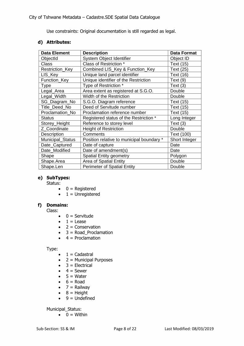
Class:
0 = Erf 1 = AH 2 = Farm Portion
Type:
0 = Subdivided
1 = Consolidated 2 = Road Closure 4 = Park 5 = Remainder of Township
Municipal_Status:
0 = Within
1.4. Data Set: Restriction Feature Class a) Abstract:
All original surveyed restrictions (Servitudes, Leases etc.). Data has been aligned to WGS84.
b) Content Status:
Relevant Time Period: Current Update Frequency: Continuous
c) Constraints on accessing and using the data:
Access constraints: None
City of Tshwane Metadata – Cadastre.SDE Spatial Data Catalogue
Sub-Section: SS & IM Page 8 of 22 Last Modified: 08/03/2019
Use constraints: Original documentation is still regarded as legal. d) Attributes:
Data Element Description Data Format
ObjectId System Object Identifier Object ID
Class Class of Restriction * Text (15)
Restriction_Key Combined LIS_Key & Function_Key Text (25)
LIS_Key Unique land parcel identifier Text (16)
Function_Key Unique identifier of the Restriction Text (9)
Type Type of Restriction * Text (3)
Legal_Area Area extent as registered at S.G.O. Double
Legal_Width Width of the Restriction Double
SG_Diagram_No S.G.O. Diagram reference Text (15)
Title_Deed_No Deed of Servitude number Text (15)
Proclamation_No Proclamation reference number Text (15)
Status Registered status of the Restriction * Long Integer
Storey_Height Reference to storey level Text (3)
Z_Coordinate Height of Restriction Double
Description Comments Text (100)
Municipal_Status Position relative to municipal boundary * Short Integer
City of Tshwane Metadata – Cadastre.SDE Spatial Data Catalogue
Sub-Section: SS & IM Page 9 of 22 Last Modified: 08/03/2019
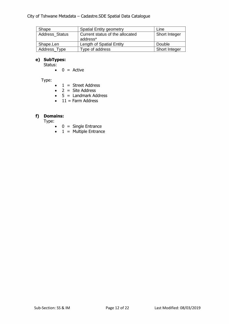
1.5. Data Set: Sectional Scheme Feature Class a) Abstract:
All original surveyed Sectional Schemes and Council approved second dwellings (duet plans) represented by a geo-referenced hexagon. Data has been aligned to WGS84.
b) Content Status:
Relevant Time Period: Current Update Frequency: Continuous
c) Constraints on accessing and using the data:
Access constraints: None Use constraints: Original documentation is still regarded as legal. Placement of sectional
title units correlates to aerial photography where possible. d) Attributes:
Data Element Description Data Format
ObjectId System Object Identifier Object ID
Class Class of property on which SS is located *
Text (15)
Sectional_Scheme_Key
Combined LIS_Key & Function_Key Text (25)
LIS_Key Unique land parcel identifier Text (16)
Function_Key Unique identifier of the Sectional Scheme
Text (10)
Type Type of Sectional Scheme * Short Integer
Floor_Area Area of Sectional Scheme Unit as registered at S.G.O.
Double
Participation_Quota_Percentage
Participation Quota Percentage of SS Unit as registered at S.G.O.
Double
SG_Diagram_No S.G.O. diagram reference Text (15)
SG_Approval_Data Date of S.G.O. approval Date
Title_Deed_No Current Title Deed of SS Unit Text (20)
Unit_Label SS Unit number Text (4)
Sectional_Scheme_Name
Name of Sectional Scheme as registered at S.G.O.
Text (60)
Sectional_Scheme_No
Number of Sectional Scheme as registered at Deeds Office.
Text (15)
Status Registered status of the SS * Short Integer
Remark Comment Text (99)
Municipal_Status Position relative to municipal boundary * Short Integer
Date_Captured Date of capture Date
Date_Modified Date of amendment(s) Date
Shape Spatial Entity geometry Polygon
Shape.Area Area of Spatial Entity Double
Shape.Len Perimeter of Spatial Entity Double
e) SubTypes:
Status:
City of Tshwane Metadata – Cadastre.SDE Spatial Data Catalogue
Sub-Section: SS & IM Page 10 of 22 Last Modified: 08/03/2019
0 = Registered 1 = Unregistered 7 = Not Verified
f) Domains:
Class:
0 = Erf 1 = AH 2 = Farm Portion
Type:
0 = Sectional Scheme 4 = Real Rights
Municipal_Status:
0 = Within
Notes on the Function Key The purpose of the Function Key is to identify a particular attribute or feature associated with another geographical feature, invariably a land parcel. Thus, a Sectional Title Scheme that is located on a farm portion or an Erf in a Township is allocated a Functional key which is used to uniquely identify each Sectional Title Unit in the Scheme. Similarly, a Functional Key is allocated to Servitude on a land parcel that uniquely identifies it thereby allowing for multiple servitudes on a land parcel to be identified uniquely. The structure of the Function Key, which is a maximum of 9 characters, is as follows: Characters 1-3 :- Identifies the owner of the Function Key i.e. the Function Key custodian. Characters 4-5 :- Identifies the type of feature or attribute being described. Characters 6-9 :- A unique (sequential) number for every feature. For the Cadastral Feature Datasets the following Functional Keys have been allocated.
Function Description
GEOSS GeoInformation, Sectional Scheme
GEORR GeoInformation, Real Right (on SS)
GEOSV GeoInformation, Servitude
GEOLS GeoInformation, Lease
GEOCS GeoInformation, Conservation
GEORP GeoInformation, Road Proclamation
GEOPR GeoInformation, Proclamation
RMMSV Revenue Management Multiple Services
Datasets for other business units may describe Function Keys that are particular to such datasets. Reference should be made to the metadata of those datasets for further information. Alternatively, information regarding Function Keys for other units is contained on the Intranet under the Maps and GIS tab.
City of Tshwane Metadata – Cadastre.SDE Spatial Data Catalogue
Sub-Section: SS & IM Page 11 of 22 Last Modified: 08/03/2019
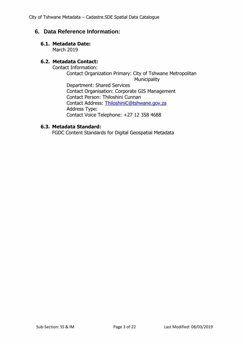
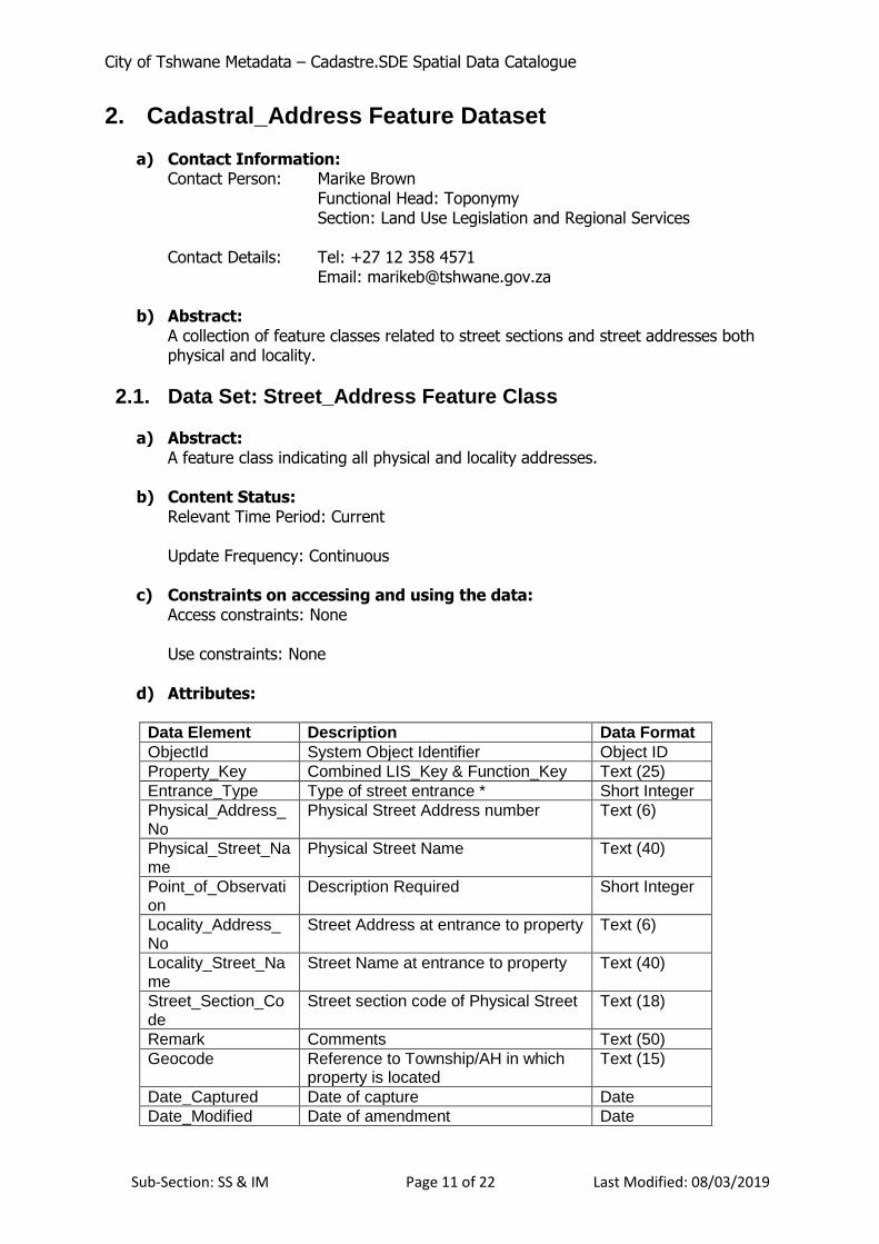
2. Cadastral_Address Feature Dataset a) Contact Information:
Contact Person: Marike Brown Functional Head: Toponymy Section: Land Use Legislation and Regional Services
This dataset is a collection of non-topographical feature classes used primarily for cartographic purposes (map production).
3.1. Data Set: Administrative_Area Feature Class a) Abstract:
A collection of administrative boundary features. b) Content Status
Relevant Time Period: Current. Update Frequency: As and when changes occur.
c) Constraints on accessing and using the data:
Access constraints: Only Sub-Type 14 (City of Tshwane Regions). Use constraints: None.
d) Attributes:
Data Element Description Data Format
ObjectId System Object Identifier Object ID
Name Name of Administrative Area Text (50)
Date_Captured Date of capture Date
Date_Modified Date of amendment Date
Shape Spatial Entity geometry Polygon
Shape.Area Area of Spatial Entity Double
Shape.Len Perimeter of Spatial Entity Double
e) SubTypes:
Type:
14 = Tshwane Regions f) Domains:
None
3.2. Data Set: Community_Point_Feature Feature Class a) Abstract:
This is a feature class depicting ‘Points of Interest’ for the Tshwane Municipal area. The data are derived from numerous internal and external sources and thus certain subsets
City of Tshwane Metadata – Cadastre.SDE Spatial Data Catalogue
Sub-Section: SS & IM Page 14 of 22 Last Modified: 08/03/2019
of the data are not made available. The domain values for the Class field have been categorised into logical groupings.
b) Content Status:
Relevant Time Period: Current Update Frequency: Continuous
c) Constraints on accessing and using the data:
Access constraints: Limited access. The following fields, only, are available to the public: ObjectId
Name
Type, with the following restrictions. Only the following Sub-types:
o 0 (domain value 115)
o 1 to 13; o 15 to 25 (Type 23 – domain value 180)
Class
LIS_Key
Date_Captured
Date_Modified
Shape
Use constraints: None
d) Attributes:
Data Element Description Data Format
ObjectId System Object Identifier Object ID
Name Name of Community Point Text (70)
Type Type of Community Point * Long Integer
Class Class of Recreation * Text (50)
LIS_Key Unique land parcel identifier Text (20)
Date_Captured Date of capture Date
Date_Modified Date of amendment Date
Shape Spatial Entity geometry Point
e) SubTypes:
Type: 0 = Accommodation 1 = Animal Welfare
2 = Cemetery 3 = Court 4 = Cultural Site 5 = Education 6 = Emergency Service 7 = Entertainment 8 = Foreign Representation 9 = Government Department 10 = Health Service 11 = Library 12 = Museum
13 = Municipal 15 = Police
City of Tshwane Metadata – Cadastre.SDE Spatial Data Catalogue
Sub-Section: SS & IM Page 15 of 22 Last Modified: 08/03/2019
16 = Post Office 17 = Recreation 18 = Refuse Site 19 = Shopping Centre 20 = Societies Institutes Research 21 = Sport 22 = Tourism Information 23 = Transport 24 = Worship Place
25 = Social Service f) Domains:
Class: 1) Education
35 = Primary 36 = Secondary 37 = Tertiary
2) Emergency Services 40 = Ambulance 41 = Fire Brigade
3. Time Period of Content: ................................................................. 2 3.1. Time Period Information: ................................................................. 2 3.2. Currentness Reference: .................................................................... 2
a) Contact Information: .......................................................................... 4 b) Abstract: ........................................................................................... 4
1.1. Data Set: FarmBoundary Feature Class .......................................... 4 a) Abstract: ........................................................................................... 4 b) Content Status: .................................................................................. 4 c) Constraints on accessing and using the data: ......................................... 4 d) Attributes: ........................................................................................ 4 e) SubTypes: ......................................................................................... 5 f) Domains: .......................................................................................... 5
1.2. Data Set: LandBoundary Feature Class ........................................... 5 a) Abstract: ........................................................................................... 5 b) Content Status: .................................................................................. 5 c) Constraints on accessing and using the data: ......................................... 5 d) Attributes: ........................................................................................ 5 e) SubTypes: ......................................................................................... 5 f) Domains: .......................................................................................... 6
1.3. Data Set: LandParcel Feature Class ............................................... 6 a) Abstract: ........................................................................................... 6 b) Content Status: .................................................................................. 6 c) Constraints on accessing and using the data: ......................................... 6 d) Attributes: ........................................................................................ 6 e) SubTypes: ......................................................................................... 7 f) Domains: .......................................................................................... 7
1.4. Data Set: Restriction Feature Class ................................................ 7 a) Abstract: ........................................................................................... 7 b) Content Status: .................................................................................. 7 c) Constraints on accessing and using the data: ......................................... 7 d) Attributes: ........................................................................................ 8
City of Tshwane Metadata – Cadastre.SDE Spatial Data Catalogue
Sub-Section: SS & IM Page 21 of 22 Last Modified: 08/03/2019
1.5. Data Set: Sectional Scheme Feature Class ...................................... 9 a) Abstract: ........................................................................................... 9 b) Content Status: .................................................................................. 9 c) Constraints on accessing and using the data: ......................................... 9 d) Attributes: ........................................................................................ 9 e) SubTypes: ......................................................................................... 9 f) Domains: ........................................................................................ 10
Notes on the Function Key ................................................................. 10
a) Contact Information: ........................................................................ 11 b) Abstract: ......................................................................................... 11
2.1. Data Set: Street_Address Feature Class ......................................... 11 a) Abstract: ......................................................................................... 11 b) Content Status: ................................................................................ 11 c) Constraints on accessing and using the data: ....................................... 11 d) Attributes: ...................................................................................... 11 e) SubTypes: ....................................................................................... 12 f) Domains: ........................................................................................ 12
a) Contact Information: ........................................................................ 13 b) Abstract: ......................................................................................... 13
3.1. Data Set: Administrative_Area Feature Class .................................. 13 a) Abstract: ......................................................................................... 13 b) Content Status ................................................................................. 13 c) Constraints on accessing and using the data: ....................................... 13 d) Attributes: ...................................................................................... 13 e) SubTypes: ....................................................................................... 13 f) Domains: ........................................................................................ 13
3.2. Data Set: Community_Point_Feature Feature Class .......................... 13 a) Abstract: ......................................................................................... 13 b) Content Status: ................................................................................ 14 c) Constraints on accessing and using the data: ....................................... 14 d) Attributes: ...................................................................................... 14 e) SubTypes: ....................................................................................... 14 f) Domains: ........................................................................................ 15
3.3. Data Set: Transportation_Network Feature Class ............................. 16 a) Abstract: ......................................................................................... 16 b) Content Status: ................................................................................ 17 c) Constraints on accessing and using the data: ....................................... 17 d) Attributes: ...................................................................................... 17 e) SubTypes: ....................................................................................... 17 f) Domains: ........................................................................................ 17
a) Contact Information: ........................................................................ 19 b) Abstract: ......................................................................................... 19
4.1 Data Set: Contours_2013_1M Feature Class ................................ 19 a) Abstract: ......................................................................................... 19 b) Content Status: ................................................................................ 19 c) Constraints on accessing and using the data: ....................................... 19
City of Tshwane Metadata – Cadastre.SDE Spatial Data Catalogue
Sub-Section: SS & IM Page 22 of 22 Last Modified: 08/03/2019