52
Council Report V The EuroCouncil ♦ Belgium April 2003
Page 1Council Report V
Council Report V
The EuroCouncil ♦ BelgiumApril 2003

Page 2
©2003 The Town Paper
CounCil RepoRt VDiane Dorney
Publisher and Managing Editor
Laurence AurbachProduction Editor
Claire FleischerCopy Editor
This publication sponsored by:
The Knight Program in Community Building
andJoanna Alimanestianu Architect
Christian Lasserreand
The Congress for the New Urbanism
Copies of this publication are available for purchase.
Please send a check or money order for $17 to The Town Paper: (add $5 for shipment overseas)
The Town Paper309 Main Street
Gaithersburg, MD 20878

Page 3Council Report V
Contents
Contributors
Introductory Articles
Twelve Challenges for European Urbanism ............................4Toward Ecological Urban Growth Patterns/
The Gift of Wonder..............................................................5
Learning From les Etats-Unis................................................6
The CEU: Continuing the Effort Overseas........................ 7
New Urbanism in Europe .................................................... 8
Differences Between the Historic Urban Experience
in Europe and the USA ...................................................... 10
All’aperto: Reflections of a New Urbanist in Europe ......... 11
The Reformed Urban Block ............................................... 12
European Projects
Baden Nord (Switzerland) ................................................... 14
Rue de Laeken (Belgium) ................................................... 16
Järla Sjö (Sweden) .............................................................. 18
Quartier am Tacheles (Germany) ........................................ 20
Rocester (Britian) ............................................................... 22
Robert Adam is director of Robert Adam Architects in Winchester, UK, where he has practiced since 1977. He has a long history of work on speculative housing and master planning and founded the Popular Housing Group in 1995. Adam’s work, including numerous papers and books, is widely published and exhibited; he lectures world-wide and is one of the founders of INTBAU.
Joanna Alimanestianu has an architectural practice in Brussels, Belgium and Southampton, N.Y. Already by the late 1980’s, Joanna was a new urbanist by instinct if not by training, as she took on the role of urban and architectural advisor to the Rue de Laeken redevelopment project in downtown Brussels.
Igor Anderson is an architect with Urbaplan in Lausanne, Switzerland, a consulting company on land use develop-ment and urban design. He has previously worked for Calthorpe Associates and has carried out research on land development regulations for the Congress for the New Urbanism.
Charles C. Bohl is a research associate professor and director of the Knight Program in Community Building, a program associated with the University of Miami School of Architecture. He has taught planning and urban design at UNC-Chapel Hill and NCSU School of Design. Bohl is author of “Placemaking: Town Centers, Main Streets and Transit Villages.”
Javier Cenicacelaya practices as an architect in Bilbao in partnership with Iñigo Saloña. He is a professor at the School of Architecture of the University of the Basque Country. He was editor of the magazine Composicion Arquitectonica - Art & Architecture, and has served as dean of the School of Architecture of the University of Miami.
Victor Deupi is an assistant professor of architecture at the University of Notre Dame and has been visiting design critic at the university’s Rome Studies Program. Deupi practices, lectures and writes on classical architecture and traditional urbanism. His work has been exhibited throughout England, the U.S. and Italy.
Andrés Duany is one of the founding members of the Congress for the New Urbanism. He and his wife, Eliza-beth, are partners of Duany Plater-Zyberk & Company, the architectural and planning firm based in Miami. Their firm has planned over 200 new towns and urban revitalizations. They teach new urbanism principles and philosophies at the University of Miami.Audun Engh is project manager for the Foundation for Ur-
Council Report V
Brandevoort (Netherlands) ................................................. 24
Bilbao Study (Spain) .......................................................... 26
FMV Shipyard (Norway) .................................................... 30
Laslea (Romania) ................................................................ 32
American Perspectives
Advanced Techniques in Urban Design ........................... 39
Shop and Awe: The Peril of American-Style
Commercial Development for Europe ............................... 42
A Warning to Europe: Traffic Specialists
Will Destroy Your Cities .................................................... 45
European Resources
The Prince’s Foundation for the Built Environment ......... 46
The Foundation for Urban Renewal .................................. 47
International Network for Traditional Building,
Architecture & Urbanism: Mission and Activities ............ 49
Council for European Urbanism: Forming a Charter ......... 50
ban Renewal (Stiftelsen Byens Fornyelse), where he organizes numerous exhibitions and workshops promoting traditional urbanism and architecture. Engh has worked as a lawyer, including real estate practice, and runs the “Frie Kunster,” a center for traditional arts in downtown Oslo.
Matthew Hardy trained as an architect in South Australia, where he specialized in houses and public buildings, and has a Ph.D. in architectural history from the University of Wales for his work on the influence of Hippocratic ideas of health on house and city planning. None of which qualified him to be secretary of INTBAU, the position he now holds.
Harald Kegler, architect and town planner, is the founder and director of the Laboratory for Regional Planning (Labor für Regionalplanung) in Wittenberg. Through research, practice and education, the Laboratory addresses urban transformation, regional planning and the charrette method. Kegler practiced for 12 years at the Bauhaus Dessau Foundation, taught at the University of Miami and has received awards for planning and urban reconstruction.
Christoph Kohl is a free-lance architect with Rob Krier · Christoph Kohl Architekten in Berlin. In partnership with Rob Krier, he practices an anti-modernist yet pro-innovation urbanism that emphasizes and reanimates the spatial context of a town. Kohl is co-author of the books “Potsdam Kirch-steigfeld,” and “The Making of a Town.”
Léon Krier is an architect and urban designer who has de-signed numerous projects both realized and theoretical. Krier has been professor of architecture at several universities; his ideas form part of the urban development recommendations of the OECD. He has lectured globally and authored many essays and books, including “Architecture: Choice or Fate.”
John Massengale is an architect and town planner. Co-Chair of the Council, with Bill Dennis, he is the Director of the New School for Traditional Architecture and Urbanism (TAU) in Charleston, S. C.. He is the author, with Robert A.M. Stern, of “The Anglo-American Suburb and New York 1900, Metropolitan Architecture and Urbanism 1890-1915” and has a grant from the Graham Foundation for Advanced Studies in the Visual Arts to write Do the Right Thing, Notes from a Metaphysical Planner.
Susan Parham, as director of CAG Consultants, leads projects in economic and community development, urban planning policy, urban design and consultation and stakeholder engage-ment. She has worked as rapporteur and program analyst for a number of OECD projects and initiatives. Parham is currently
a part-time Ph.D. candidate in the Cities Programme at the London School of Economics and Political Science.
Duane Phillips is head of Duane Phillips, Architecture and City Planning, which has carried out building and planning projects in and around Berlin since 1993. Proj-ects range from restoration of historical structures, to the new embassy for the State of Qatar, to studies for reuse and reintegration of former Soviet military bases. The practice has acted as DPZ’s contact architect in Germany and Bosnia since 1996.
Jerker Söderlind is an architect, journalist, writer, researcher and lecturer at the KTH Royal Institute of Technology. His published books include “Architecture for Industrial Renewal,” “The Renaissance of the City,” “Greater Stockholm Suburban History” and “Agenda ECN.” Söderlind conducts research in upgrading and renewal of modernist suburban areas, cultural production systems and integration of traffic and land use planning.
Wolfgang Sonne is a lecturer in the history and theory of architecture at the Department of Architecture and Building Science at the University of Strathclyde in Glasgow. He has taught the history of urban design at the Eidgenössische Technische Hochschule in Zurich and coordinated the postgraduate program/exhibition “Urban Forms: Conditions and Consequences.” Sonne has also taught at Harvard University and the University of Vienna.
Peter Swift is principal of Swift & Associates in Longmont, Colo., where he consults in transportation engineering and urban design. Swift has published and lectured extensively, and has partnered with local governments to study the linkages between street typologies and public safety.
Gabriele Tagliaventi is a full professor of architecture at the University of Ferrara. As a partner with Tagliaventi & Associates, he has designed numerous award-winning urban redevelopments throughout Europe. Tagliaventi is curator of several major traveling exhibitions, vice-director of the journal “A&C International” and author/editor of many books on urbanism.
Galina Tahchieva is a director for Duany Plater-Zyberk & Company. She received her master’s degree in urban planning from the University of Maimi and has worked as a designer and project manager on numerous urban projects worldwide.
Cover by Marianne Cusato.

Page 4 Introductory Articles
EuroCouncil ParticipantsApril 2003Council For European Urbanism
The Declaration Of BrugesApril 2003
The Council for European Urbanism is dedicated to the well being of the people of Europe by
the re-creation of humane cities, towns and countryside.
European cities, towns and countryside are under threat from:
Waste of land and cultural resources.
Social segregation and isolation.
Monofunctional development.
Loss of local, regional and national cohesion, character and distinctiveness.
Twelve Challenges for European Urbanism:
1. Poorly integrated housing: slab and tower blocks and low-density sprawl.
2. Unintegrated public and commercial functions: business parks and out-of-town shopping and enter-tain ment centres.
3. Disposable buildings and short life-cycle developments.
4. Degradation of public places.
5. Public realm made from left-over space.
6. Car-dominated transport.
7. Indiscriminate road and street design.
8. Disconnected street networks.
9. Autocratic planning methods and over-regulation.
10. Destruction of villages through decay, abandonment or suburbanisation.
11. Disruptive infill and dysfunctional zoning in urban areas.
12. Non-contextual guidelines and regulations in historic areas.
The Council for European Urbanism will take up the 12 Challenges, develop a program, or-ganization and strategy and set up national chapters. A draft charter will be drawn up and presented in Stockholm in November 2003.
Adam, RobertAlimanestianu, Joanna
Andersen, IgorAurbach, Laurence
Baganha, JoséBenson, JackieBirkiye, Sefik
Bodenschatz, HaraldBohl, Charles C.Bolgar, Benjamin
Bontempi, Pier CarloCamp, Robert D.
Cenicacelaya, JavierChael, MariceChielens, Bart
Choynowski, PiotrComitta, Thomas J.
Cornelio da Silva, José ManuelCulot, Maurice
Cusato, MarianneDe Mot, Olivier
Dennis, William L.Deupi, Victor
Dorney, Diane L.Dover, Victor B.
Drijver, PeterDuany, Andrés
Durand Rival, BernardElmlund, PeterEngh, AudunFairfax, Anne
Fleeman, JeffreyFranck, ChristineGlomsrod, Bjorn
Hall, LauraHannecart, Gaetan
Hardy, MatthewJersenius, HakanKegler, Harald
Kohl, ChristophKonefke Herzeel, Steve
Kramer, Robert R.Krier, Léon
Laconte, PierreLambrechts, Veronique
Lasserre, ChristianLegler, Charles M.
Maschmeier, Karl-HeinzMassengale, John
Mollo, LuigiMsika, Jean-Loup
Murrain, PaulMycielski, Maciej
Naeyaert, TruiPhillips, Duane
Plater-Zyberk, ElizabethRowland, Lucy M.
Salona, InigoSammons, RichardSchuman, Ulrich
Sodal, ArneSöderlind, JerkerSonne, Wolfgang
Steil, LucienSwift, Peter
Tagliaventi, GabrieleTahchieva, Galina
Van Eecke, BernardVerschuren, Peter
Verstuyft, NicoWarburton, David
Whalen, Paul

Page 5Council Report V
Participating at the EuroCouncil in Bruges and the Washington, D.C., CNU conference in June made me aware of how far the techniques of traditional urban planning have been modernized and that they are now capable of resolving most urban planning issues worldwide. A number of minds have been decisive in rediscovering, maturing and applying these techniques. New urbanism reflects a practical approach to human settle-ments, and it is hoped that it will remain free of any forms of dogmatism and moral-ism. Rather than impose alien forms of architecture and urbanism, new urbanists
consider it self-evident that human settle-ments should be ecological, respectful of human differences, of their desires for privacy as well as for community — in short, that they should sustain humans in justifiable pursuits of happiness.
Pondering over the meaning of a multitude of brilliant projects, realizations and presentations, it became clear to me that most of our projects merely respond to actual commissions; and even though they represent immense improvements within the established urban develop-ment areas, they generally do very little to improve the ecological viability of urban growth patterns. Settling the deserts, or swelling existing megalopolitan areas looks to me in the long term to be eco-logically untenable and probably futile, whatever the quality of the urbanism and architecture. Global warming is a fact, and evidencing the global ecological carrying capacities of the planet Earth, by continents and regions, seems to me to be now the foremost goal of science; it is not a matter of academic interest but of the survival of the human race.
The foremost goal of new urbanism is, then, not merely to improve the qual-ity of development and buildings but to ensure that future urban growth patterns and their buildings be founded on an eco-logical rather than a suicidal metabolism of man and nature. The new urbanist lexicon delivers the tools and new urban-ism the visions of ecological settlements, but it is up to science to identify the sites and density of such settlements, their maximum populations, and the quality of their agriculture, forestry and industries.
Towards Ecological Urban Growth PatternsBy Léon Krier
Note: The following dinner address was given to the EuroCouncil at La Reserve hotel, in the coastal city of Knokke-Heist, Belgium on April 4, 2003.
Ladies and Gentlemen,
I would not dare to have the pretension of being able to talk about architecture. But I am very proud that so many famous architects of the new urbanism movement have taken the time to come to this beautiful part of Belgium – of Flanders, where the trees are still bent by the North Sea wind along the canals of Damme and Bruges, where the sunsets and the colors fire the imagination of the Flemish painters, where the geese still freely fly and where the people still live in an environment which is more than acceptable.
Because when you look at the world today, there are fewer and fewer people who have this gift of awareness, the gift of being able to see the beauty of simple things: “le don d’émerveillement.” And when you look at the beauty those people created years ago – those who built Bruges, Venice, Damme, Ghent, the cathedrals, parts of Italy and Greece – that is beauty, and thousands of people come to look at it.
But a lot of those people are depressed. They spend one-third of
The Gift of WonderBy Léopold Lippens, MayorKnokke-Heist, Belgium
their lives in a car with their heads 20 centimeters from the roof; they spend another one-third of their lives working in offices where the ceilings are very low; and when they get home they live in apartments where the ceilings crush them. That is why I am glad we could create, from scratch, a beautiful project in Heulebrug, where the cost of living has been kept low and where the people, instead of living in a “ghetto” of poverty, will be living in a place, in sur-roundings of quality that they will be proud and happy to live in.
I am so happy that Monsieur Krier and Monsieur Duany have made this
DRAWING BY LÉON KRIER
possible. Because instead of creating these awful modern buildings – that all look alike and that all have been imag-ined by architects who think by giving a certain accent they are doing something fantastic – they have produced an ab-solutely marvelous master plan. And a master plan is like a Persian rug, which in itself is beautiful. But if I give you a scissors and you cut one piece of this Persian rug, you will only have a piece of cloth, and the Persian rug will have disappeared. So this master plan, where not everything is calculated in return of money, but where beauty still has its place, is very important.
Léon Krier
That is why we are lucky to have in our community architect Bart Chielens, who definitely believes in new urban-ism and has given a new impulse to the building in our community.
Why are mountains so beautiful? Because they are sacred. God and Moses went up the mountain to pray.
There are a lot of different ways in architecture. There are a lot of different ways in the mountains. Those going up bring us to the summit. In architecture that is what new urbanism is doing in the world.
Thank you very much.
Victor Dover and Gabriele Tagliaventi are welcomed by Léopold Lippens, Mayor of Knokke-Heist in Belgium.
THE TOWN PAPER
THE TOWN PAPER
Order Back Issuesof The Council Report
Council Report I: Eight New Urban Towns. (October 2001, 52 pp.) $17
Council Report II: Infill and Plazas (April 2002, 40 pp.) $17
Council Report III/IV: Style and Urbanism; New Urban Codes and Design Guidelines (April 2003, 64 pp.) $25
Council Report V: The EuroCouncil: European Urbanism (October 2003, 52 pp.) $17
Send check or money order to:
The Town Paper309 Main StreetGaithersburg, MD 20878
For more information and online order form, visit the Town Paper website:www.TNDtownpaper.com

Page 6
Learning From les Etats-UnisBy John Massengale
A common comment among the Eu ropea n s at t he Belg ia n EuroCouncil was, “We don’t need
new urbanism – that’s an American idea – we have old urbanism.” That’s one reason why forming a new Council for European Urbanism was a more popular choice than forming a European chapter of the Con-gress for the New Urbanism.
The idea that new urbanism is simi-lar or equivalent to old urbanism implies that new urbanism is just about the form of cities. But NU is more than that. It is different than old urbanism in three fun-damental ways that should be considered during the formation of the CEU:
1. New urbanism accommodates and specifically addresses contemporary issues such as parking counts, financing, expectations of developers and negotiating the development with the community. It is a body of work and ideas that grows more complete every year.
2. New urbanism is a collective movement, which can accomplish more than individuals acting individually. While on the whole, Europeans have tended to approach each project individu-ally and as individuals.
3. The Europeans are very so-phisticated when it comes to designing traditional urbanism, but the American new urbanists have learned more about selling traditional urban design to their fellow practitioners; to the various bodies that must finance, approve and build the designs; and to the general public, both citizens and buyers.
There are several possible lessons from American new urbanism about how the CEU might be organized and how it will grow. A charter like the CEU’s is not intended to address how to build a move-ment others will want to join, or how the CEU will become an effective fulcrum for changing contemporary European plan-ning. For the CEU to succeed, strategies for its success need to be developed, and then the ideas of the CEU need to be sold to others.
Just having the right ideas is not enough – Jane Jacobs’ brilliant book from the 1960s has had less effect on the ground than new urbanism, even though new urbanism came almost two decades later and initially said very little that Jacobs hadn’t said.
A hundred years ago, f ledgling institutions like New York’s Municipal Arts Society were grappling with similar issues (it’s interesting to go back and read the writings from the time of people like Raymond Unwin, because their description of the state of urban design then was almost identical to ours today). In a history of the Municipal Arts Society, my friend and co-author from “New York 1900,” Gregory Gilmartin, wrote:
The Municipal Art Society’s his-tory is well populated with strange and brilliant figures – and with others far less scintillating as well – but perhaps the les-son to draw here is ultimately about the power and usefulness of civic groups in general. Too many New Yorkers assume that the voting booth represents their only hope of effecting change, and that the choice of one candidate over another is the only available method of participating in the democratic process. A civic group like MAS, however, tries to shift the focus of political debate from candidates to specific issues. By reshaping the political landscape it can win concessions from candidates of any political stripe. ...
Finally, one hardly expects to ap-prove of every position MAS has taken
a flawed example like Kentlands had an enormous impact. The Cabinet Secre-tary of the United States Department of Housing and Urban Development visited Kentlands, and an alliance between HUD and the CNU was born. That resulted in new urban reforms for federal housing standards, and the involvement of new ur-ban practitioners in the tearing down and replacement of the worst federal housing from the past.
The Governor of Maryland visited Kentlands, and a leading new urbanist was hired to set up and run a new Maryland Department of Smart Growth. Countless developers, public officials and homebuyers visited Kentlands and saw that standard development in the area was not good enough.
Second, the process of building projects like Kentlands and Laguna West developed expertise and knowledge. In-dividuals like Andrés Duany and Peter Calthorpe first became the mavens of that body of knowledge – finding sympathetic specialists to work with like Rick Chell-man, Rick Hall and Bob Gibbs – and then helped to disseminate it in lectures around the country. Books like “The Geography of Nowhere,” “Suburban Nation” and “The Next American Metropolis” followed, and other new urbanists such as Elizabeth Plater-Zyberk took the message into uni-versity programs.
The ideas had to be developed and then communicated. As the ideas spread,
others like Rob Steuteville and Diane Dorney came along with publications, and many worked at their local level to get the word out.
The “word” was not just about good urban design, even though good design was at the core. Victor Dover’s talk in Bruges showed exactly how the new urban polemic has developed for the public forum. Bob Gibbs’ talk in Stockholm will show how new urbanists worked to engage all the specialists involved in building today in order to succeed.
The third factor in the success of
Robert Adam, left, and John Massengale, right.
new urbanism is the same one we saw in the Municipal Arts Society. The CNU gave new urbanism a public face that in-dividuals never could, transforming a body of work into a national movement. The CNU office in San Francisco was there to speak for new urbanism, to coordinate efforts, form alliances with other organiza-tions, fund research and publications, and hold annual meetings that grew from 200 to 1,200, introducing people to each other and their work and providing a sense of community.
The congresses showed that new urbanism was bigger than any individual. And for other organizations like the ULI and the Sierra Club to endorse the principles of new urbanism, the principles had to be bigger than any single person or office. Charismatic leaders were essen-tial in selling the ideas, but they needed the imprimatur of an organization and a movement.
During its own process of growth, the CEU needs to specifically address this question: What are the elements most needed for old urbanism to overcome the current political, economic, social and artistic systems? In order to answer that question, it’s necessary to identify the big-gest impediments to change. In the United States, those included architects, planners, engineers, financial systems, developers, builders, environmentalists, fire chiefs and NIMBYs.
What are the next steps for the
CEU? How will it sell its ideas to others? Who will sell its ideas to others, and who will make those ideas?
Will it grow like the CNU – es-sentially a professional organization for designers, developers and their consultants – or will it emulate successful grass-roots organizations, as the environmentalists did in the Sierra Club and the Nature Conservancy?
The American experience can provide lessons for all these questions, but in the end, it is the Europeans who must answer the questions.
over the past hundred years, and some will surely object to the Society’s basic prem-ises. But critics might bear in mind the advice of Richard Weiling, a Municipalian for more than thirty years. “You alone can do almost nothing,” he wrote in his 1942 memoirs, “but if you . . . belong to some group where you all have a common ideal there is almost nothing you cannot do.”
– “Shaping The City, New York and the Municipal Art Society” (New York, Potter, 1995): xii.
Today, there’s a good deal of con-sensus in America about what has led to success for new urbanism and the CNU.
It relied, of course, on a growing underly-ing aversion to sprawl and an increasing desire for neighborhood and community. But in terms of what New Urbanists did to make new urbanism succeed, the most important thing was to build successful models of an alternative that people could see. The critics are right that Seaside is a resort and not a town, but it was in the form of a town, and it was a place that people could see and experience. In a way that a book never could, Seaside was a model that started a movement.
Wherever there’s been a good proj-ect, new urbanism has taken off. Even
John Massengale.
Page 7Council Report V
What reason could there be for yet another organization dedi- cated to the projection of a
civilized European urbanism?There are reasons enough listed in
the proto-charter that was conceived at the recent Bruges Council, but none is as important as one that remained unstated: Whatever other organizations exist, they are not effective enough.
Year after year, cities and landscapes wither under the proposals of private de-velopers and public agencies. We know that the damage is due to venality, confu-sion and ineptitude; but the root causes have not been fully analyzed and the antidotes systematically formulated. To address this, the Congress for European Urbanism will be dedicated in Stockholm this November 2003.
The CEU will study both failures and successes, wherever they may be found. The intention is to evaluate both socialist and capitalist practices and hybrids too. To study practices current, emergent and long-dead. The members of the CEU intend to become experts in whatever works best in the long run; to project alternative paradigms into public consciousness; to embed them into exist-ing systems, and thus to deflect the course of modernity’s ravages on the European environment.
This will require a state of mind uncommon in an old and immensely sophisticated civilization: It will require an intellectual effort free of the ideolo-gies. No preconception, whether political, social or artistic, will be exempt from use or scrutiny. There will be clear analysis and formulations clearly translated into operational techniques. The CEU will produce policy papers and model projects, membership drives, educational cur-ricula, codes and ordinances, technical standards, manuals, propaganda, public agitation — whatever engagement is necessary to replace the systems that are doing the damage.
To that end, what is to be the model
of organizational reform? We might ask ourselves what the last campaign of reform was that changed the planning paradigm comprehensively. There is only one contender: The Congress International de L’Architecture Moderne, CIAM. In a brilliant campaign, from 1927 to 1959, CIAM succeeded in changing the world, the result being the preceding disastrous half-century and present state of European urbanism.
Today, CIAM’s propositions are what we must oppose. Its inventions have destroyed vast sectors of urban and rural Europe. The fact that they are sustained, this despite constant evidence of failure, that they still control the design Man-darinates, is reason to emulate it all the more. CIAM as an instrument was able to impose itself categorically on a mature culture. This is something to be closely studied to see what can be learned. If we are to counter the depredations of CIAM, then let us use CIAM’s methods.
How do we know that this strategy
The CEU: Continuing the Effort OverseasBy Andrés Duany
will succeed? Of that there is already evidence. Twelve years ago a group of American urbanists assembled. They too were concerned by the destruction of magnificent cities and the abuse of the beautiful countryside.
This small group grew to become the Congress for the New Urbanism, now with over 2,000 members. The CNU was based explicitly on the CIAM model — with a charter, congresses, various special-ized publications, polemical projects, and alliances with groups that add the CNU urban position to their core agendas.
CNU’s success in affecting real re-form has been stunning. It is fast becom-ing a comprehensive alternative.
An alternative to what? That, too, could be of interest to the
CEU. We know that we have a common cause, but perhaps we may also have a common opponent. What the CEU has against it is not just the classic, social-ist, rationalist, austere manifestations of CIAM; but also its late degenerate manifestation: American-style sprawl.
For CIAM only became monstrous when the premises set forth by its clever and well-intentioned European pioneers were grafted onto the hyper-affluence and the market orientation of North America. The result was no longer the “tower in the park” but a virulent sub-urbanism that consumes the countryside and eviscerates the cities.
This is the new affliction of Europe. The problem is no longer just the imposi-tion of modernism where it is not justified. It now encompasses the kitsch housing clusters, the highway shopping centers and the isolated office parks. These will prove to be the most insidious of problems, because they are temporarily profitable and superficially popular.
This is a mature phenomenon in the United States, and it is only now well understood. Only recently have Europeans encountered the affluence and laissez-faire governments that afforded the widespread ownership of automobiles — at the rate of one per adult. It is only recently that the huge European middle class has become extensive enough to impose its cultural preferences at the urban scale. It was not too long ago that the then-working class was grateful to find a dwelling, wherever and however it was. Now everyone has a choice … and it is not reason or high culture that is the common preference. It is only very recently that the European consumer society has become massive enough to break the commercial logic of the urban center and to access the proliferation of cheap products through big-box retailing.
This phenomenon is nothing less than the globalization of North Ameri-can living habits. This will become the greatest of all the challenges confronting the CEU.
The American Congress for the New Urbanism has studied these problems and has formulated alternatives.
The CNU is at the service of the CEU, for the advice and the solidarity that it can provide.
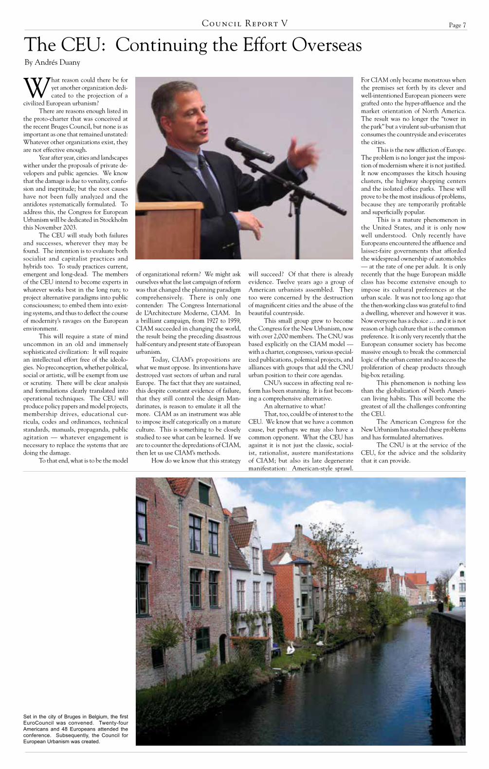
Set in the city of Bruges in Belgium, the first EuroCouncil was convened. Twenty-four Americans and 48 Europeans attended the conference. Subsequently, the Council for European Urbanism was created.

Page 8
On November 19, 1992, His Royal Highness The Prince of Wales visited a site in the historical
center of Brussels accompanied by seven young architects.1 The press extensively covered the event because the site was fa-mous as the “red district,” and the prince was there for the demolition of one of the first skyscrapers built in the core of the European capital city in the ’60s.
It was a rainy day and the area was completely covered with mud, but the spirit of HRH was high; a positive mood was inexorably spreading among the group. In fact, after a 30-year, perverse process of desertification of the urban center – with thousands of inhabitants forced to abandon their houses and move into the suburbs to make room for tow-ers to host the European Commission offices – something different was about to happen. After years and years of protests, counter-projects, and fierce battles between the citizens and the politicians, the largest investor in the Belgian area (the AG Group, today known as the Fortis Group) decided to start a completely new policy in its real estate division.
Instead of building a new tower for their headquar-ters, the AG managers opted for the demolition of the old skyscraper. In its place, they decided to construct a new urban neighborhood around a large urban block, where half of the site was to be occupied by a new courtyard building headquarters, and the rest left for the reconstruction of a series of urban houses along the main street, Rue de Laeken.
If not revolutionary, one could say this was highly radical. Rebuilding the urban fabric instead of suburban-izing the center. Demolishing skyscrapers and develop-ing new traditional mixed-use buildings. Revitalizing the urban area by offering apartments and townhouses for young couples and families as an alternative to the suburban escape.
The project (which became famous as the “Recon-struction of the Rue de Laeken”), started in 1989 with an international architectural competition held by both the AG Group (thanks to the efforts of Christian Lasserre and Joanna Alimanestianu), and the Fondation pour
l’Architecture, under the supervision of Maurice Culot and Caroline Mierop. It was the logical conclusion of a campaign of counter-projects and “urban struggles” aimed at offering alternatives to the destruction of the traditional city that followed the 1958 Expo and the decision by the EU to establish its main headquarters in Brussels. Despite the opposition of the architectural establishment and the lack of social conscience by local politicians and EU bureaucrats, this operation of urban renaissance opened the way to new methods of interven-tion in the urban area, demonstrating that profit and a harmonious environment were not contradictory terms.
After the demolition, work on the site continued as scheduled. In February 1993, construction began on the new traditional buildings that had started as winning entries in the 1989 International Architectural Com-petition. Finally, the new block was officially opened in spring 1995 with 41 residences, one office, 13 shops and two underground parking lots, plus the new office complex for the insurance company, arranged around the inner courtyard.
The Reconstruction of the Rue de Laeken in Brussels definitely marked the success of new urban-ism in Europe. It demonstrated that a new policy of urban development was available, that the traditional city could be a model for the construction of the new urban environment. It was very successful and gave rise to many imitations all around the city of Brussels and throughout the old continent. For the first time, a differ-ent image of their capital city was offered to Europeans, an image different from the usual sadness emanated by the EU bureaucracy.
Nevertheless, the movement for the new urbanism in Europe has a complex and deeply rooted history. Right after the end of World War II, a professor in Rome, Save-rio Muratori, started a series of research projects on ar-chitectural typology and urban morphology. His studies presented the process of constructing the European city as based upon simple and rational rules: the persistence of the urban lot, the evolution of the architectural type, the organization of the lots within a larger aggregation (the block), the hierarchical structure of the network of streets and squares. While Muratori was working in Italy, a German professor, Karl Gruber, published a book on the urban development of the German city through history, presenting another alternative to the theories of the modernist movement.2
However, the key figure in the development of new urbanism in Eu-rope is no doubt Léon Krier. While he continues the tradition of Muratori and Gruber, Krier has provided architects, planners, students and professors with a global theory on how to design and build new traditional cities – a true compre-hensive alternative to modernism. His projects for La Villette in Paris (1976) and the new quarters for the European Union in Luxembourg (1978) presented for the first time the manifesto for a polycentric city built as a federation of urban neighborhoods. His influence all around Europe has been immense.3
Another decisive factor in the development of the movement was surely the campaign HRH The Prince
of Wales started with his famous speech at Mansion House on the reconstruction of Paternoster Square in London (December 1987) and, later on, with his exhibition (1988) and book (1989), both titled “A Vision of Britain.” This innovative inter-vention in the public arena led to several interesting projects in academic, cultural, and professional fields. Not only did the Prince found an Institute of Architecture that carried out summer schools from 1992–98 under the direction of Brian Hanson, but he personally engaged in the planning and development of an exten-sion to the city of Dorchester: the new town of Poundbury, whose masterplan is due to Léon Krier. So important was HRH’s role that in 1992 the University of Bologna organized an international exhibition and conference dedicated to “A Vision of Europe” and opened by the
Prince himself.4 The aim of this event was both to docu-ment the many instances of new urbanism throughout Europe and the United States, and to offer the movement a place to meet and discuss. It was the first time projects such as Seaside and Windsor were displayed in Europe. Thus the international Triennale on Architecture and Urbanism was initiated; its activities continued with the conferences of 1996 (Urban Renaissance) and 2000 (The Other Modern 1900-2000) in Bologna, and a traveling exhibition sponsored by the EU reaching the cities of Istanbul, Oslo, Brussels, San Sebastian, Bilbao, Lisbon, Strasbourg, etc.5
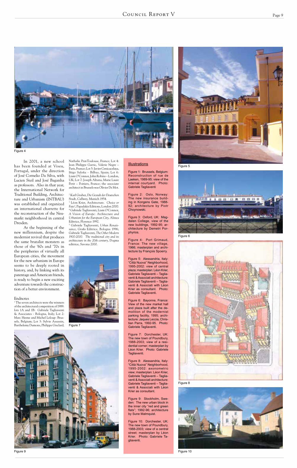
The AVOE Triennale, by publishing a series of books and catalogues, documented the vitality of the movement throughout Europe and the world. Works by architects like Manuel Manzano Monis in the recon-struction of the town of Fuenterrabia, Spain, François Spoerry in the invention of the resort village of Port Grimaud, France, Christian Langlois in the extension to the Senate in Paris, France and many others, suddenly offered a completely new perspective on architectural history in the 20th century. One could say that new urbanism in Europe linked with an endless tradition of building classically and regionally, one often neglected by the modernist ideological position that considered only those examples of architecture and town planning that were consistent with its paradigm.
Finally, an interesting chapter in the history of new urbanism in Europe is the one of the architectural schools. The very first venue for teaching tradition was the La Cambre school in Brussels where many of the contemporary active architects in Belgium and France were introduced to the principles of the European city by Maurice Culot. After the school was closed during the urban struggles of the ’70s, the Institute of Archi-tecture and Urbanism at the University of Bologna started to teach new urbanism under the direction of Ivo Tagliaventi, by inviting as visiting professors Léon Krier, Maurice Culot, Caroline Mierop, Alberto Ustarroz and many other traditional architects and town plan-ners. An affiliation of the Bologna school has been with the University of Ferrara in the mid-’90s, where Piotr Choynowski, Jean François Lejeune, Michael Lykoudis and Samir Younes taught together with many other European architects.
New Urbanism in EuropeBy Gabriele Tagliaventi
Figure 2
Figure 1
Introductory Articles
Figure 3
Page 9Council Report V
In 2001, a new school has been founded at Viseu, Portugal, under the direction of José Cornelio Da Silva, with Lucien Steil and José Baganha as professors. Also in that year, the International Network for Traditional Building, Architec-ture and Urbanism (INTBAU) was established and organized an international charrette for the reconstruction of the Neu-markt neighborhood in central Dresden.
At the beginning of the new millennium, despite the modernist revival that produces the same brutalist monsters as those of the ’60s and ’70s in the peripheries of virtually all European cities, the movement for the new urbanism in Europe seems to be deeply rooted in history, and, by linking with its parentage and American friends, is ready to begin a new exciting adventure towards the construc-tion of a better environment.
Endnotes1 The seven architects were the winners of the architectural competition of 1989: lots 1A and 1B: Gabriele Tagliaventi & Associates - Bologna, Italy; Lot 2: Marc Heene and Michel Leloup- Brus-sels, Belgium; Lot 3: Sylvie Assassin, Barthelemy Dumons, Philippe Gisclard,
Illustrations
Figure 1: Brussels, Belgium: Reconstruction of rue de Laeken, 1989-95: view of the internal courtyard. Photo: Gabriele Tagliaventi
Figure 2: Oslo, Norway: The new insurance build-ing in Kongens Gate, 1988-92; architecture by Piotr Choynowski.
Figure 3: Oxford, UK: Mag-dalen College, view of the new buildings, 1992-95; ar-chitecture by Demetri Por-phyrios.
Figure 4: Port Grimaud, France: The new village, 1966; masterplan and archi-tecture by François Spoerry.
Figure 5: Alessandria, Italy: “Città Nuova” Neighborhood, 1995-2002: view of central plaza; masterplan: Léon Krier, Gabriele Tagliaventi – Taglia-venti & Associati architecture: Gabriele Tagliaventi – Taglia-venti & Associati with Léon Krier as consultant. Photo: Gabriele Tagliaventi.
Figure 6: Bayonne, France: View of the new market hall and plaza built after the de-molition of the modernist parking facility, 1995; archi-tecture: Jaques Leccia, Chris-tian Parra, 1992-95. Photo: Gabriele Tagliaventi.
Figure 7: Dorchester, UK: The new town of Poundbury, 1988-2003; view of a resi-dential corner; masterplan by Léon Krier. Photo: Gabriele Tagliaventi.
Figure 8: Alessandria, Italy: “Città Nuova” Neighborhood, 1995-2002: axonometric view; masterplan: Léon Krier, Gabriele Tagliaventi – Taglia-venti & Associati architecture: Gabriele Tagliaventi – Taglia-venti & Associati with Léon Krier as consultant.
Figure 9: Stockholm, Swe-den: The new urban block in the inner city “red and green flats”; 1992-96; architecture by Sune Malmquist.
Figure 10: Dorchester, UK: The new town of Poundbury, 1988-2003; view of a central street; masterplan by Léon Krier. Photo: Gabriele Ta-gliaventi.
Figure 4
Figure 5
Figure 6
Figure 7
Figure 8
Figure 9 Figure 10
Nathalie Prat-Toulouse, France; Lot 4: Jean Philippe Garric, Valerie Negre – Paris, France; Lot 5: Javier Cenicacelaya, Iñigo Saloña – Bilbao, Spain; Lot 6: Liam O’Connor, John Robins – London, UK; Lot 7: Joseph Altuna, Marie Laure Petit – Poitiers, France; the associate architect in Brussels was Olivier De Mot.
2 Karl Gruber, Die Gestalt der Deutschen Stadt, Callwey, Munich 1954.3 Léon Krier, Architecture. Choice or Fate?, Papadakis Editions, London 2000.4 Gabriele Tagliaventi, Liam O’Connor, A Vision of Europe: Architecture and Urbanism for the European City, Alinea Editrice, Florence 1992.5 Gabriele Tagliaventi, Urban Renais-sance, Grafis Editrice, Bologna 1996; Gabriele Tagliaventi, The Other Modern 1900-2000. The traditional city and its architecture in the 20th century, Dogma editrice, Savona 2000.

Page 10
New urbanism seeks to learn from the traditional city. The historic urban experience is, therefore,
of some importance. The United States and Europe share a significant common cultural and political heritage. It is often assumed that the historic urban experi-ence in the United States is also substan-tially the same as that in Europe. This is not the case.
Each collection of states on each side of the Atlantic shares a common crisis in urban sprawl and suburbanization and needs to learn from one another. We must ensure that, in our common attempts to solve a shared problem, we do not create a cultural homogenization of a different kind. We need to understand our dif-ferences.
Europe is even less of a single entity than the United States. A rudimentary understanding of European history will make this obvious. It is a continent with a long history of very diverse and often violently conflicting cultures. These dif-ferences leave their physical mark. While individual states in the United States have very different characters and laws, under the Union they have all worked to the same fundamental political and social
principles and with a common official language. Indeed, the predominant social and political pressure in a growing United States was precisely to unify the divergent cultures of immigrant groups. This unity of culture has also left its physical mark
The unique history of the United States is that of the greatest and fastest colonization of land in history. The creation of new towns took place at a remarkable pace. As Frederick Jackson Turner said in the later 19th century, “the existence of an area of free land, its continuous recession, and the advance of American settlement westward, explain American development.” There is bound to be a character to this kind of develop-ment. It was described by an English visitor in 1827: “The very streets seemed to be starting up of their own accord, ready made … as if … a great boxful of new houses had been sent by steam from New York and tumbled out on the half-cleared land.”
In Europe four characteristics predominate in historic cities – a direct
response to local geography or topology, the geological origin of building materi-als, varied land ownership patterns and the complexity of progressive growth over a long period. These cities are not disordered but they have an order that is often not immediately evident and not easily susceptible to analysis.
In all these respects, the predomi-nant European urban experience is differ-ent from that of the United States.
The subservience of the urban plan to the underlying topography and the geological origin of building materials are a consequence of the preindustrial origin of most European towns. Without the benefit of industrial technology it was a waste of scarce resources to do other than respond to the local environment as it was found. In particular, the movement of heavy building materials over very poor quality roads was difficult, and sophisticat-ed local construction techniques evolved around available building materials and the local climate. These give each area, sometimes of no more than a few square miles, its own unique character.
Beyond the eastern seaboard and the southern rivers, most cities in the United States were founded and laid out
Differences Between the Historic Urban Experience in Europe and the USABy Robert Adam
in the age of steam. There was both the belief in and the capability to conquer nature. Local topography seemed insig-nificant in the face of a rapid colonization that was seen, in the words of Thomas Jefferson in 1824, as “the progress of man from the infancy of creation to the present day.” There also existed the means and technology to construct similar buildings economically and at speed. The avail-ability of virgin timber and invention of the balloon frame house in 1830 allowed the same building type to be transported by train and erected anywhere. (In much of western and southern Europe there had been a timber shortage for centuries.)
The progressive growth of many Eu-ropean cities from very small historic cores set on crossroads or river crossings (often dating back for millennia) led to primary street patterns radiating out from these originating features. Historic cities were very small, there was usually no anticipa-tion of significant growth and an urban administration that was either minimal or had quite different priorities to any we would recognise today. Progressive and unplanned growth and the passage of time
also led to varied patterns of land owner-ship, which could reflect random subdivi-sion or simply land grabs in times of social instability. The principal exceptions to these complex city plans are the gridded remnants of Roman street plans, the inner core of some fortified cities and 18th and 19th century organized urban expansion. Such plans were often responding to rapid colonization of sparsely populated coun-tryside by a dominant incoming culture or the need to accommodate a rapid growth in population – the same factors behind the colonization of the North American continent in the 19th century.
Indeed, it is this urban grid im-posed on land regardless of topography and beyond the immediate area of urban development that is the predominant character of the American city. The 1785 Federal township-and-range grid system was a typical pragmatic response to land colonization necessitated by unprec-edented growth – the population of the United States increased by 400 percent from 1800 to 1850.
Aberdeen, South Dakota. A typical land colonization plan. The grid allows for extensive future growth in accordance with the founding layout.
Cranbrook, Kent, England. A typical small historic town of a type much valued in England. At least three different transect types are intermixed within a hundred yards of one another.
Berlin. A typical European historic urban plan. Founded around an ancient river crossing with radial routes out, rationalized at a later date for fortification and with a grid plan for nineteenth-century expansion.
See ADAM, page 48
Introductory Articles

Page 11Council Report V
How could it have come down to this – how could I have forgotten so quickly? When did I lose my sense of commitment and responsibility? Basically, this is the truth – after several years of living in a run-down, rust-belt dump, I find
myself on academic leave in Rome, sitting atop the Janiculum Hill with a view over the entire city and in particular the Pantheon dome, bull’s-eye from my living room window. My wife forced this on me. So I really can’t think about new urbanism at the moment, I’m too preoccupied. Moreover, I’m on paternity leave from my sabbatical. Everything seems more important – even the difference between ruchetta and rucola (the former grows wild). And really, what urban problems are we talking about? I look around the city – at least the one in which I’m currently living – and new urbanism feels like someone else’s problem. Like that of the poor bastard I was a few months ago, living in the middle of nowhere. Then I had the time and energy to fight for good urbanism – what else could I have done?
I’m lazy now – I walk everywhere, and when I have to travel more than 20 minutes by foot, I rely on public transportation. I don’t own a car or a mottorino. I hid my driver’s license in a drawer full of American items that I no longer use – I hate my picture anyway. I support the local economy even if it means having to go to five or six vendors at a time just to do my weekly shopping. I frequent the neighborhood farmers’ market and practice Roman dialect with the locals – “euh Vi, stai’beh?” But I don’t fight for new urbanism anymore – not even in Italy, where if you look carefully you can find some dreadful things occurring. The simple truth is that the established historical centers of Europe make it difficult for people like me to concern themselves with the sprawl that is spreading along major growth corridors and transportation routes, and choking the peripheries of many cities and towns. I have become a closet new urbanist, and I’m not sure if this is what is supposed to happen to me now that I’ve arrived in Mecca.
So I live well and remain out of touch. I’m an urban hermit. I’m a new father. I am lost, liter-ally and metaphorically, in a wealth of beauty and pleasure. But that’s precisely why cities are so natural and wonderful, isn’t it? I don’t abuse it though – I’ve returned to saying my prayers before I go to bed. I’ve even started going to Mass on Sunday mornings, this after 18 years of complacent agnosticism in America. Actually, it’s far easier to go to church than to avoid it because there are over 350 sacred buildings in Rome and one on nearly every street corner. Remaining doubtful in Rome would make my daily life so unbear-ably difficult that it’s basically not worth it. And the architecture is so good anyway. Having a spiritual void eventually catches up with you, and nowhere is this more poignant than in Rome. Yet I do not belong to a community in the American sense of the term, except of course among the American community here. My European friends laugh at me. I am laughable.
Americans often ask me, “Is it really that good in Rome?” I tell them, “Yes, only better.” As a closet new urbanist, I’ve discovered that one of the major differ-ences between Europeans and Americans is basically this: Europeans have a healthy skepticism about everything, whereas Americans have a strong sense of optimism as to what they can accomplish. Europeans look askance at any glib charlatan who claims that he or she has the right answer to any problem. In contrast, Americans will refine their methods and techniques however much it takes to achieve a suitable degree of efficiency and productivity – just getting it right. The balance between the two is es-sential, but when taken to extremes the former leads to dysfunction and the latter to naiveté. Sadly, things are not in balance.
Papa Wojtyla prays for peace – it resonates strongly in Italy. I concur. I’m branded a pacifist – a pejorative term in North America. Like French fries. Words matter a great deal in Europe, particularly among our English friends. They do not use the expression “senior citizens” to describe old people – they just say OAP’s; that is, “old age pensioners.” Not older or elder, just old. They call a toilet a toilet too, as they are not concerned with rest rooms and powdered noses. The English do wear swimming costumes, and at the very least that sounds as silly as our bathing suits. Most surpris-ingly though, Italians do not dine all’fresco, they never have – at least not by choice. All’fresco refers to being in prison, where it’s cold. To dine all’fresco means either to eat in the jailhouse or to have something freshly made, like bread – the two are not mutually exclusive. The Italians prefer to dine all’aperto (in the open), usually in streets and piazzas, or sometimes in gardens.
Italians like food. It’s scenographic like their cities and buildings – a stage for daily living. The Baroque church facades of Rome are carved in marble, all twisted and curled as if they were made of fusilli pasta and chopped vegetables. The residential buildings are painted the color of penne alla vodka (tomatoes and cream). Fish, fruits, grains, wild beasts, and other exotic flora and fauna can be found in the many mosaics and frescoes that grace the ancient and modern buildings of Rome. A day doesn’t go by when one doesn’t think about having a good meal. I can’t remember the last time I had a bad meal. Nevertheless, I don’t like eating foreign food in Rome, even though there are many Chinese, Indian and other excellent ethnic restaurants throughout the city. I prefer eating Roman food – not Tuscan or Venetian, not Neapolitan or Sicilian, just plain Roman. I can enjoy those other types of cuisine when I visit their respective regions – and I do. But in Rome, I prefer to remain local. After all, where else can you eat such excellent regional cuisine? In most places throughout the world regional traditions are dying out. It often feels like globalization is an insurmountable obstacle.
Italians also live by the calendar. They adjust their lives to the lunar cycle. Like ancient astrologers concerned with the equilibrium of the elements of the human body in association with the twelve-fold zodiac, the Italians follow the course of the
seasons microscopically. Spring starts on the equinox, and summer on the solstice – the same applies to fall and winter. The academic calendar closely follows this cycle, superimposing on it liturgical and feast days. Therefore mid-summer is not July 4th (strange, I realize) but August 15th, Assumption Day. Every day is a celebration of a martyred saint or religious festival. Recently, the day the clocks changed to daylight savings time (the feast of St. Benedict), everyone in Rome decided to go to the park for an afternoon stroll – spring had officially started.
Closely allied with this phenomenon is the general disregard for ice, air conditioning and drafty rooms. Most drinks in Italy come slightly chilled, not frozen. It is generally believed here that ice kills the flavor of most anything. It is true. In England they serve their ale at room temperature, just cold enough. Building interiors are designed naturally to maximize solar gain in the winter, and keep out the sun in the summer. In Italy, your body is in harmony with the seasons and there is nothing more disturbing than to break that rhythm. Air conditioning is hugely overrated. A curious belief here in Rome is that drafts carry with them evil currents that adversely affect the liver – never aim a portable fan at an Italian unless you are willing to run the risk of insult.
The liver is a source of endless conversation. The ancient Romans knew its importance and so when founding towns and settlements they would dissect the liver of a local animal to see whether it was healthy. Based on their findings they would judge if a particular site was environmentally suitable. Augurs would then watch for signs – wind and bird patterns, topographical features etc. – and determine their exact significance. Then the surveyors would divide the land and draw up the lots. I think
new urbanists should do the same. When was the last time you had your liver examined? I sincerely believe that once you have achieved excellent urbanism (a healthy liver) you can focus your attention more carefully on architecture (flesh). People in general relate more to buildings than to urban structures, even though the latter is the one that impacts hu-man behavior more directly. We have a long way to go in America on both fronts, and cosmetic surgery won’t amount to much.
Europeans have their shortcomings too. Italians, in particular, are notoriously deferential to the English. Ever since the British milordi established the “Grand Tour” of Italy in the 16th century, the Italians have developed their own version of gentle-manismo. No self-respecting Italian man would ever be seen in public without his English brogues or Scot-
tish hunting jacket (the waxed or quilted Barbour). At the same time, certain sections of central Tuscany are referred to as Chiantishire due to the prevalence of Englishmen who reside there and consume mass quantities of local plonk. Americans are not so highly regarded – at least not from my perspective. The fact is that from the point of view of connoisseurship, we offer Italians very little. Where we excel is in popular culture and mass production. In music, television, media and entertainment, Americans have the edge. The largest wine producer in Italy is American owned. But I don’t have a television, I rarely go the cinema (they curiously dub all films in Italy – it’s terribly annoying), I don’t listen to the radio, and I don’t frequent late nightclubs.
So I drink wine and follow football – I mean real football, the one that is played with a ball and your feet. I’m passionate about the game. After 20 years of following the American version, I gave it up in just under two hours. Standing in the North Bank of Highbury stadium in North London on August 22nd 1989 watching Arsenal defeat Coventry City was all I needed to drop the American game permanently. For those who do not know, Highbury is the Wrigley Field of European football. All new urbanists should visit Highbury – and Wrigley Field. I also take long walks – not as a default setting of what one does on a Sunday afternoon in Europe, but as a real pleasure, as one of the highlights of my day that I share with my wife and daughter. I can, it’s easy. What’s not so easy is really not worth mentioning – the little things. If you start complaining about the million little things you’ll never be content.
Peter is a writer, Joan teaches yoga, Ian is a pediatrician, Lucas is only 8 months old, Theo plays the bongos, Rebecca is a graffiti scholar (epigrapher), and Ed makes furniture. They are all like me – here temporarily, although some slightly longer. They all draw inspiration from this place. They are new urbanists without knowing so. That’s the beauty of Rome – you don’t need to be a specialist to appreciate it. Yet leaving it is heartbreaking – even the thought of it puts me on edge. I really can’t complain though. Yesterday I felt as if I was getting old, but today I feel young again. My daughter is Roman. I will always be closely attached to this city.
Despite everything, everything seems more natural and straightforward here, as if years of fumbling forward have resulted in an unexpected sense of rightness. In America we work so hard at trying to get it right, and we always come up short – I think. Maybe it’s simply a matter of time – I hope so. After all, we’ve had new urbanism in America for over 20 years, and look at how much it has accomplished (I’m serious). Nevertheless, America still depresses me. There’s far too much to do there to save the natural and built environment. Yet unless I win the lottery – to which I regularly do not subscribe – the thought of staying permanently in Europe remains seriously doubt-ful. Hence, Rome is a kind of intense therapy, my daughter’s birthplace. I often tell people, when they ask me what I’m working on, that I’m developing a thesis on personal happiness. It’s either that or tiramisu. We pay for our sins. No doubt I’ll return to the United States someday soon and become an active new urbanist in the Congress for the New Urbanism (CNU) – again. But this time, I’ll have a European equivalent: the CEU, or Council for European Urbanism, with which I can share my energy. It may not seem so alone anymore in the middle of nowhere.
All’aperto: Reflections of a New Urbanist in EuropeBy Victor Deupi
“La bellezza e la promessa della felicita (Beauty is the promise of happiness)” Italian proverbNew Urbanism – isn’t that a popular movement in North America aimed at addressing the problems of suburban sprawl and growth management? FAQ
* * *

Page 12
The most advanced urban movements of the 20th century seem actually to have been anti-urban in character. The famous models, such as Eb-
enezer Howard’s “Garden City” (1898), Bruno Taut’s “Dissolution of the City” (1920), Le Corbusier’s “The corridor street must be killed” (1925), and Frank Lloyd Wright’s “Broadacre City” (1935) have one thing in common: They all wanted to overcome the traditional dense city by replacing it with a new kind of landscaped dwelling entity. They all vividly promoted the destruc-tion of architecturally defined urban spaces, with strict zoning according to different functions based on a more or less exclusive model of social life. Walter Gropius and Ernst May brought major consequences to urban design with the formula “from the block to the row,” designing famous diagrams for the journals “The New Berlin” and “The New Frankfurt” in 1929 and 1930. Thus the de-velopment of a modern urban design seemed to be fixed.
But there was another direction in modern urban-ism that did not desire to overcome the existing cities, but to reform them. It was not an intermediary step between the traditional urbanism of the 19th century and the avant-garde urbanism of the 20th century, as the avant-gardists wanted it to be seen. Rather, it was a broad international movement that developed many valuable and successful models for a reformed metropolis. After the fall of the avant-garde they remain, having only to be rediscovered and reconsidered.1
A central task of modern urban design was to improve the housing conditions in the dense city. The appropriate model for the metropolis was the reformed perimeter block: an urban block, built up at its edges and thus fronting the street with an urban facade, but also delivering green spaces and light with a large, planted inner courtyard.
First attempts were undertaken in Berlin with the famous houses by Alfred Messel in the 1890s. Behind his picturesque and traditionalist facades, large green spaces announce a real reform of metropolitan housing.2 The possibilities for building a whole neighborhood according to this model were explored in Hermann Jansen’s beautiful drawings for the Tempelhofer Feld near Berlin in 1910 (Fig. 1). In Jansen’s renderings, a well defined “architectural square” is combined with a “recreational square”; the large uniform blocks with their greened courts have monumental openings to the public streets.3 These ideas were brought to the scale of a comprehensive city plan by Eliel Saarinen in his plans for Munkkiniemi-Haaga near Helsinki in 1915 (Fig. 2). His impressive bird’s-eye view promises both dense urban life and homey neighborhood dwellings.4
Another center for the development of a new urban block design was Paris. The competition of the Rothschild Foundation for a social housing block at the Rue de Prague in 1905 brought up many ideas. The two main strategies were to open the block to the street and to create green interior spaces. A mixture of both was chosen by the winner, Adolphe Augustin Rey, who tried to justify his design by scientific diagrams showing the movement of air.5 It was this block model, and not Le Corbusier’s proposal to break with the existing city, that was followed in the 1920s and ’30s when the extension along the Boulevard Peripherique was built.6
All over Europe, ideas for the reform of the urban block were developed, often adapted to the re-gional building tradition. Perhaps the most successful city extension of the 20th century was the quarter of Amsterdam-South according to the plans by Hendrik Petrus Berlage (1917). It dealt with the challenges of modern urban life by differentiating between metropoli-tan thoroughfares, with uniform architecture fitted to car movement, and neighborhood squares, with picturesque architecture fitted to the pedestrian.7 In Vienna, the superblocks of the Höfe of the 1920s fit admirably into the urban fabric, and created a well defined, high-quality model somewhere between the traditional dense block and the Siedlungen of the suburbs.8
Even in Berlin (the Mecca of modernist housing estates after Martin Wagner had become city architect in 1925), Erwin Gutkind built a number of impressive blocks with large green courts that did not destroy the street space.9 The Italian Novecento movement invented a new kind of simplified, sophisticated clas-sicism to express modern life in metropolitan facades. The famous Ca brütta by Giovanni Muzio (1922) and
the wonderful urban houses by Giuseppe de Finetti in Milan are only the most obvious examples that created a modern city from the spirit of the classical.10 Even in the United States, where dense business centers and suburbs of single-family houses were radically differentiated, some impressive examples of reformed housing blocks were built within the skyscraper city: the Park Avenue Apartments by Warren & Wetmore (published in Hege-mann and Peets’ “American Vitruvius” in 1922), or the Phipps Garden Apartments by Clarence Stein in 1929, just to mention some important New York examples.11
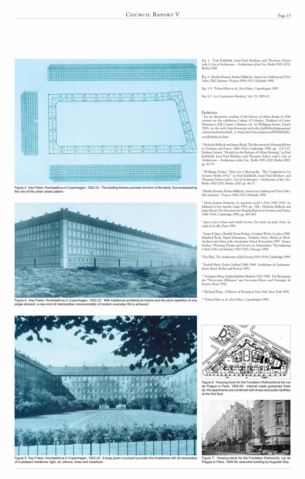
One of the most striking examples can be seen at the periphery of modern urbanism: the Hornbaekhus by Kay Fisker in Copenhagen, built in 1922–23 (Figs. 3-5).12 Here the qualities of the reformed metropolitan housing block are distilled to an almost diagrammatic clarity. The building follows the form of the block precisely and thus emphasizes the role of the urban street pattern. Its facade radically develops the idea of uniform apartments in a democratic society through the strict repetition of one single element: the window with its remarkably simplified frame. But this conceptually endless facade is carefully terminated with monumental rusticated pilasters at the corners of the building, again fixing the building exactly within its urban context. Through very traditional means of brick, framed windows and pilasters, Fisker achieved a new kind of metropolitan
monumentality of modern, daily life. But behind this explicitly urban facade, a large green court provides the inhabitants with all the necessities of pleasant residence: light, air and silence; trees and meadows; a beautiful and safe place to recreate and play. All the necessities, and nevertheless located in the city center.
Although the reformed perimeter block was de-signed for dwelling purposes, it provides the best model for accommodating also shops and restaurants on the ground floor, or offices on the upper floors. Thus it is the ideal model for a mix of different uses, and also the most sustainable model, as it can easily adapt to functional changes. Amazing results have been achieved with the design of such urban blocks in the early 20th century.
The lesson of this history is twofold: First, there is a metropolitan scale for housing that forms a challenge to a world of urban areas spreading out unsustainably into the landscape. And second, there is a tradition within 20th century urbanism that can be adopted by the new urbanism, one that contributes to a truly urban environment with positive architectural spaces, mixed uses, intensive city life and, nevertheless, good hous-ing conditions. The question is not how to overcome modern urbanism in general; the question is which are the right examples to emulate. The reformed perimeter block is one of them.Illustration credits
The Reformed Urban Block:The Forgotten Modern Metropolis of 20th Century UrbanismBy Wolfgang Sonne
Figure 1: Hermann Jansen, Tempelhofer Feld near Berlin, 1910. The reformed block at scale of the neighborhood: An “architectural square” is combined with a “recreational square”; large uniform blocks with green courts have monumental openings to the public streets.
Figure 2: Eliel Saarinen, Munkkiniemi-Haaga near Helsinki, 1915. The reformed block at scale of a comprehensive city plan: The whole city promises dense urban life and at the same time homey neighborhood dwellings.
Introductory Articles
Page 13Council Report V
Fig. 1: Paul Kahlfeldt, Josef Paul Kleihues and Thorsten Scheer (eds.), City of Architecture – Architecture of the City: Berlin 1900-2000, Berlin 2000.
Fig. 2: Marika Hausen, Kirmo Mikkola, Anna-Lisa Amberg and Tytti Valto, Eliel Saarinen: Projects 1896-1923, Helsinki 1990.
Fig. 3-5: Tobias Faber et al., Kay Fisker, Copenhagen 1995.
Fig. 6-7: La Construction Moderne, Vol. 25, 1909-10.
Endnotes1 For an alternative reading of the history of urban design in 20th century see the exhibition Culture of Urbanity: Traditions of Center Planning in 20th Century Urbanism, ed. by Wolfgang Sonne, Zurich 2000; on the web: http://www.gta.arch.ethz.ch/d/lehre/lampugnani/cultureofurbanity.html, or http://web.bsu.edu/perera/IPHS/Exhibi-
tion/Exhibition.htm
2 Nicholas Bullock and James Read, The Movement for Housing Reform in Germany and France 1840-1914, Cambridge 1985, pp. 125-137. Helmut Geisert, “Models for the Reform of Urban Housing,” in Paul Kahlfeldt, Josef Paul Kleihues and Thorsten Scheer (eds.), City of Architecture – Architecture of the City. Berlin 1900-2000, Berlin 2000, pp. 41-51.
3 Wolfgang Sonne, “Ideas for a Metropolis: The Competition for Greater Berlin 1910,” in Paul Kahlfeldt, Josef Paul Kleihues and Thorsten Scheer (eds.), City of Architecture – Architecture of the City: Berlin 1900-2000, Berlin 2000, pp. 66-77
4 Marika Hausen, Kirmo Mikkola, Anna-Lisa Amberg and Tytti Valto, Eliel Saarinen: Projects 1896-1923, Helsinki 1990.
5 Marie-Jeanne Dumont, Le logement social à Paris 1850-1930: les habitation à bon marché, Liège 1991, pp. 31ff.; Nicholas Bullock and James Read, The Movement for Housing Reform in Germany and France 1840-1914, Cambridge 1985, pp. 403-407.
6 Jean Louis Cohen and André Lortie, Des fortits au périf: Paris, les seuils de la ville, Paris 1992.
7 Sergio Polano, Hendrik Petrus Berlage: Complete Works, London 1988. Manfred Bock, Sigrid Johannisse, Vladimir Stissi, Michel de Klerk: Architect and Artist of the Amsterdam School, Rotterdam 1997. Nancy Stieber, “Housing Design and Society in Amsterdam,” Reconfiguring Urban Order and Identity 1900-1920, Chicago 1998.
8 Eve Blau, The Architecture of Red Vienna 1919-1934, Cambridge 1999.
9 Rudolf Hierl, Erwin Gutkind 1886-1968: Architektur als Stadtraum-kunst, Basel, Berlin and Boston 1992.
10 Annegret Burg, Stadtarchitektur Mailand 1920-1940. Die Bewegung des “Novecento Milanese” um Giovanni Muzio und Giuseppe de Finetti, Basel 1992.
11 Richard Plunz, A History of Housing in New York, New York 1990.
12 Tobias Faber et al., Kay Fisker, Copenhagen 1995.
Figure 3: Kay Fisker, Hornbaekhus in Copenhagen, 1922-23. The building follows precisely the form of the block, thus emphasizing the role of the urban street pattern.
Figure 4: Kay Fisker, Hornbaekhus in Copenhagen, 1922-23. With traditional architectural means and the strict repetition of one single element, a new kind of metropolitan monumentality of modern everyday life is achieved.
Figure 5: Kay Fisker, Hornbaekhus in Copenhagen, 1922-23. A large green courtyard provides the inhabitants with all necessities of a pleasant residence: light, air, silence, trees and meadows.
Figure 7: Housing block for the Fondation Rothschild, rue de Prague in Paris, 1905-09, executed building by Augustin Rey.
Figure 6: Housing block for the Fondation Rothschild at the rue de Prague in Paris, 1905-09. Internal roads guarantee fresh air; the apartments are combined with shops and public facilities at the first floor.

Page 14
Baden Nord
Igor Andersen
Baden Nord, Baden, Switzerland
The “Baden-Nord” project is one of the largest brownfield downtown redevelopment projects in Switzerland; it aims to transform a former
industrial area into a mixed-use neighborhood that integrates the needs of a big industrial company into an overall urban planning concept. The site is located in the city of Baden in the “greater Zurich area,” the most dynamic economic region of Switzerland. About 16,500 inhabitants live in Baden, and there are more than 23,000 work places, which gives an idea of the importance of Baden as a regional work destination.
The industrialization of Baden began in the early 19th century, when watermills were built along the river to power textile factories. When the industries became less dependent on the river through the ad-vent of electricity, the textile factories moved in order to allow for spatial extension of the city. Several new companies chose Baden as their site of operations. The largest and most important was ABB, one of the biggest industrial enterprises in the electrical field. First known as Brown Bovery & Cie (BBC) and founded in 1891, it became ABB in 1989 through the fusion of BBC with the Swedish company Asea.
Its Swiss headquarters is located on a 23-hectare site in Baden that is roughly three times bigger than the city’s historic center. The headquarters lie in the immediate vicinity of the city center, right on the other side of the railway tracks and main station – one of the most important transit stations in the greater Zu-rich area. With the fusion of BBC and Asea, a general reorganization of the company took place. It led to a reduction of industrial activities while focusing and developing the high-tech and engineering services. That reorganization had as an immediate consequence the underutilization of their industrial facility in Baden.
This was the context when the cooperative plan-ning process began. The city of Baden, ABB and the Federal Railway company created a planning organiza-tion called “Chance Baden Nord 2005” to transform the industrial site into a part of the city. A competition for the master plan had been won by the architectural of-fice Diener & Diener (Basel, Switzerland), and together they elaborated an urban development concept for the area. The planning process took five years and resulted in the approval by local parliament of a conceptual master plan (“Entwicklungsrichtsplan”) in 1994.
Per the local regulations, the conceptual master plan had the advantage of being flexible in its content, which was necessary as there were many unknown factors. At the same time, the master plan had a quite short administrative approval process, which allowed for quick and easy modifications when needed (actu-ally, that proved to be very successful when a major change in the disposition of a plot was made in 1999). On the other hand, the drawback of such a planning tool is that it is only binding on the public authorities, not the land owners. To circumvent that problem, the authorities signed contracts with ABB in order to make the master plan mandatory (this was of course easier with one single owner).
The only planning procedure that remained before the building permit process was to elaborate a “sondenutzungsplan” (specific plan) for each plot, allowing the city to ensure that the principles of the master plan were met.
The conceptual master plan is composed of 30 guidelines addressing four categories: 1) the massing of the buildings and the buildings to be maintained, renovated or replaced, 2) the open spaces, 3) the land uses and 4) the traffic principles and thoroughfare types. These guidelines share the following common characteristics:1
The significance of the site. Respect for the industrial heritage of the site (“genius loci”).
Respect for the industrial scale. In particular, respect for the industrial scale of existing buildings with their relatively large building volumes; the retention of flat-roof landscapes; and completion and/or conversion of existing structures (as far as possible) into closed or semi-closed courtyard ensembles with semi-private interiors and public exteriors.
Tolerance of temporary buildings. Tolerance and use of temporary buildings, parks and roads next to permanent construction (old or new) during the transitional period, with a goal of continued growth and diversification.
Stages of conversion while retaining the exist-ing grid of buildings and streets. This allows for almost any given transition from today’s situation to a new one without adhering to a fixed sequence.
Building lots. Subdivision into building lots of a size appropriate for investors.
Basic position of moderate architecture. Pre-dominance of public spaces over buildings, the latter to be of high quality, but subordinated to the new urban pattern.
Mixed-use. A careful mixture of residential and business uses to obtain continuous daytime and nighttime activities.
Public open space. Relatively small-scale pub-lic open spaces to ensure proximity to all building uses.
Access. A reduced number of parking spaces in collective structures that are directly accessible from collector roads, leaving protected building frontages to pedestrians and cyclists. Highly attractive pedestrian and bicycle connections, in particular to the railway and rapid transit stations, streetcars and bus stops.
The local neighborhood streets (with the excep-tion of the main thoroughfares) are designed to be multi-modal, with no sidewalks or fine detailing mate-rial. This has been explicitly expressed in the guidelines in order to preserve the industrial character of the area (big buildings laid directly on a tarmacked area with no specific articulation), and it has proved very successful as car drivers naturally adapt their speed to the presence of pedestrians. Note that there is no through traffic on these streets.
Besides the characterization of the guidelines, the partners defined the main structural data for the project. These included, for instance, the basic ratio for each plot of housing versus activities (for the whole area, the ratios were ¼ housing to ¾ office, industrial and civic); the amount of public open space for parks and squares to be transferred to the city without com-pensation (the owner is responsible for the cleaning costs of the soils); the maximum number of parking lots, etc.
So far, the transformation of the area is happen-ing at a good pace. Here are some examples. A former manufacturing building has been recently converted into a new cinema (five screens) with two restaurants and a commercial/entertainment hall, thus preserving a beautiful example of industrial architecture situated right in the middle of the new neighborhood along the “Trafo Platz.” A workshop built in 1905 and located along the main road now contains a restaurant on the street level with studios and apartments above. More than 120,000 square meters of office buildings have been built on the eastern section of the main road since 1993. Thirty thousand square meters of residential uses are currently in the planning process, and a competi-tion is about to be launched for a new city school (3,000 students) in the northern part of the area. Meanwhile, industrial activity continues to be strong and ongoing.
There are four main good lessons to remember from this project:
Since the beginning, the planning process has been conducted with all the main partners involved: the owner of the land (ABB), the city of Baden and the Swiss railway company (CFF). This partnership allowed full consideration the main interests applying to that strategic location: ABB wanted more office space, the city wanted more housing, a new school and control of the traffic generated, and the Swiss railway company wanted to redevelop the railway station bordering the site into a new public transportation hub.
The planning tool offers great adaptability in the plan while fixing the essentials that control the
By Igor Andersen
See ANDERSEN, page 35
Figure 1
Figure 3
Figure 2
European Projects

Page 15Council Report V
Project Name: Baden Nord
Location: City of Baden, Canton of Argovia, Switzerland
Classification: Infill (brownfield)
Designer: Diener & Diener Architekten
Consultants: Büro ur, Ueli Roth (urban plan-ning coordination)
Architects: Several
Developer: ABB Real Estate Ltd.
Design Date: 1994 (revision in 1999)
Construction Begun: 1994
Status: Under construction
Site Area: 23.2 hectares (57.3 acres)
Residential: 100,000 square meters (1.08 million square feet) housing approximately 2,000 inhabitants. Commercial: 300,000 square meters (3.26 million square feet) including industrial, office, retail and civic buildings with approximately 7,500 employees. Public & Civic Program: School (3,000 students), civic hall (for meetings, concerts, etc.), movie theater with entertainment hall, restaurants and neighbrhood shops, 2,400 parking spaces maximum.
DESCRIPTION & CREDITS FOR THE ILLUSTRATIONS
Figure 1: View of the new movie theatre. Architecture: Burkhard Meyer Partner, Baden (2002). Photo: Igor Andersen.Figure 2: Aerial picture of the area (1997) Photo: Photo Comet AG, Zurich.Figure 3: Model of the master plan concept. Photo: Büro ur, Ueli Roth.Figure 4: Illustrative Plan of the planned situation (2015) Photo: Büro ur, Ueli Roth.Figure 5: Illustrative Plan of the original situation (1989). Photo: Büro ur, Ueli Roth.·Figure 6: View of the 1905 workshop transformed into a mixed use building. Architecture: Dorer und Füchslin, Baden
(1905), renovation: Arge Eppler, Maraini, Schopp /Th. Hasler, Baden (2000). Photo: Igor Andersen.·Figure 7: Rendering of the “Power Tower” office building along the main road. Architecture: Diener & Diener, Basel
(2003) Photo: Business Images, Zurich.Figure 8: View of the newly renovated industrial hall. Architecture: Dr. Roland Rohn, Zurich (1950), renovation: Burkard Meyer
Partner, Baden (2003). Photo: Igor Andersen.
Figure 4
Figure 5
Figure 6
Figure 7
Figure 8
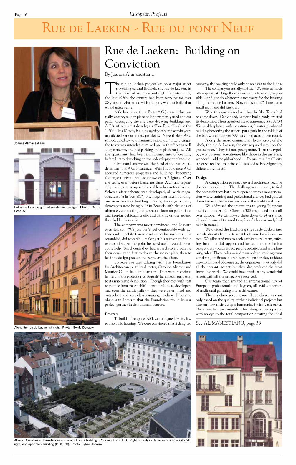
Page 16 European Projects
Rue de Laeken - Rue du pont Neuf
Joanna Alimanestianu
Rue de Laeken: Building on ConvictionBy Joanna Alimanestianu
See ALIMANESTIANU, page 38
The rue de Laeken project sits on a major street traversing central Brussels, the rue de Laeken, in the heart of an office and nightlife district. By
the late 1980s, the owners had been working for over 20 years on what to do with this site, what to build that would make sense.
A.G. Insurance (now Fortis A.G.) owned this par-tially vacant, muddy piece of land primarily used as a car park. Occupying the site were decaying buildings and A.G.’s infamous metal-and-glass “Blue Tower,” built in the 1960s. This 12-story building aged poorly and within years manifested serious egress problems. Nevertheless A.G. still occupied it – yes, insurance employees! Interestingly, the tower was intended as mixed use, with offices as well as apartments, and had parking on its platform base. All the apartments had been transformed into offices long before I started working on the redevelopment of the site.
Christian Lasserre was the head of the real estate department at A.G. Insurance. With his guidance A.G. acquired numerous properties and buildings, becoming the largest private real estate owner in Belgium. Over the years, even before Lasserre’s time, A.G. had repeat-edly tried to come up with a viable solution for this site. Scheme after scheme was developed, all with mega-structures “à la ‘60s-‘70s”: one huge apartment building, one massive office building. During those years many skyscrapers were being built in Brussels with the idea of ultimately connecting all the second floors for pedestrians and keeping vehicular traffic and parking on the ground floor hidden beneath.
The company was never convinced, and Lasserre even less so. “We just don’t feel comfortable with it,” they said. Luckily Lasserre relied on his instincts. He scrambled, did research – making it his mission to find a real solution. At this point he asked me if I would like to come help. So, though they had an architect, I became their consultant, first to design the master plan, then to lead the design process and represent the client.
Lasserre was also talking with The Foundation for Architecture, with its director, Caroline Mierop, and Maurice Culot, its administrator. They were notorious fighters for the protection of Brussels’ heritage, to put a stop to its systematic demolition. Though they met with stiff resistance from the establishment – architects, developers and even the municipality – they were determined and outspoken, and were clearly making headway. It became obvious to Lasserre that the Foundation would be our perfect partner in this unusual venture.
ProgramTo build office space, A.G. was obligated by city law
to also build housing. We were convinced that if designed
Entrance to underground residential garage. Photo: Sylvie Desauw
Along the rue de Laeken at night. Photo: Sylvie Desauw
Above: Aerial view of residences and wing of office building. Courtesy Fortis A.G. Right: Courtyard facades of a house (lot 2B, right) and apartment building (lot 3, left). Photo: Sylvie Desauw
properly, the housing could only be an asset to the block.The company essentially told me, “We want as much
office space with large floor plates, as much parking as pos-sible – and just do whatever is necessary for the housing along the rue de Laeken. Now run with it!” I created a small team and did just that.
We rather quickly realized that the Blue Tower had to come down. Convinced, Lasserre had already ordered its demolition when he asked me to announce it to A.G.! We would replace it with a continuous, five-story, L-shaped building bordering the streets, put a park in the middle of the block, and put over 500 parking spaces underground.
Along the more commercial, lively street of the block, the rue de Laeken, the city required retail on the ground floor. They did not specify more. To us the typol-ogy was obvious: townhouses like those in the surviving wonderful old neighborhoods. To assure a “real” city street we realized that these houses had to be designed by different architects.
DesignA competition to select several architects became
the obvious solution. The challenge was not only to find the best architects but also to open doors to a new genera-tion whose training and professional choices had guided them towards the reconstruction of the traditional city.
We addressed the invitations to young European architects under 40. Close to 300 responded from all over Europe. We winnowed these down to 24 entrants, all small teams of two and four, few of whom actually had built in name!
We divided the land along the rue de Laeken into parcels almost identical to what had been there for centu-ries. We allocated two to each architectural team, offer-ing them financial support, and invited them to submit a project that would respect precise architectural and plan-ning rules. These rules were drawn up by a working team consisting of Brussels’ architectural authorities, resident associations and of course us, the organizers. Not only did all the entrants accept, but they also produced the most incredible work. We could have made many wonderful streets with all the projects we received.
Our team then invited an international jury of European professionals and laymen, all avid supporters of traditional planning and architecture.
The jury chose seven teams. Their choice was not only based on the quality of their individual projects but also on how their designs harmonized with each other. Once selected, we assembled their designs like a puzzle, with an eye to the total composition creating the ideal
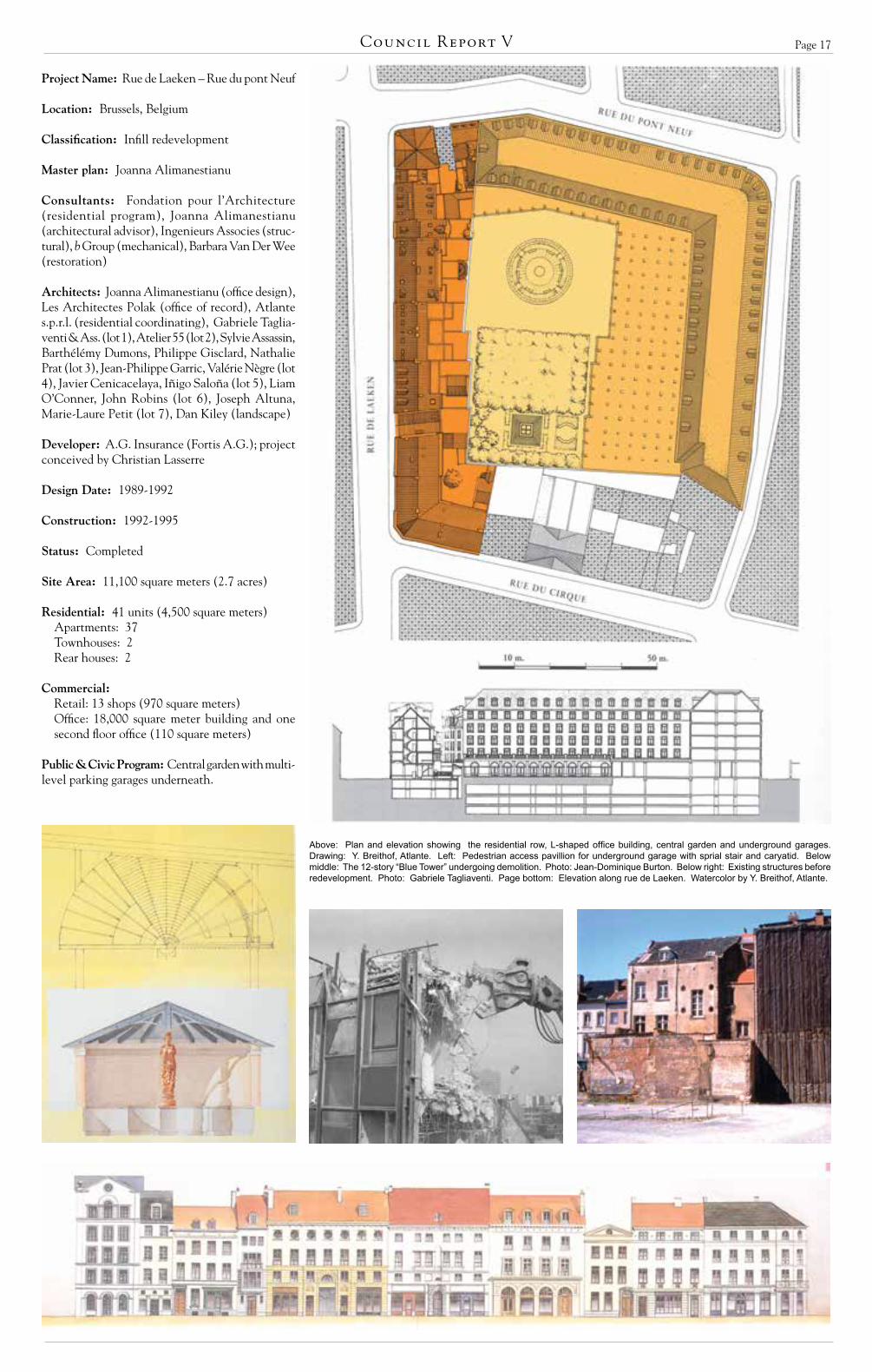
Page 17Council Report V
Project Name: Rue de Laeken – Rue du pont Neuf
Location: Brussels, Belgium
Classification: Infill redevelopment
Master plan: Joanna Alimanestianu
Consultants: Fondation pour l’Architecture (residential program), Joanna Alimanestianu (architectural advisor), Ingenieurs Associes (struc-tural), b Group (mechanical), Barbara Van Der Wee (restoration)
Architects: Joanna Alimanestianu (office design), Les Architectes Polak (office of record), Atlante s.p.r.l. (residential coordinating), Gabriele Taglia-venti & Ass. (lot 1), Atelier 55 (lot 2), Sylvie Assassin, Barthélémy Dumons, Philippe Gisclard, Nathalie Prat (lot 3), Jean-Philippe Garric, Valérie Nègre (lot 4), Javier Cenicacelaya, Iñigo Saloña (lot 5), Liam O’Conner, John Robins (lot 6), Joseph Altuna, Marie-Laure Petit (lot 7), Dan Kiley (landscape)
Developer: A.G. Insurance (Fortis A.G.); project conceived by Christian Lasserre
Design Date: 1989-1992
Construction: 1992-1995
Status: Completed
Site Area: 11,100 square meters (2.7 acres)
Residential: 41 units (4,500 square meters)Apartments: 37Townhouses: 2Rear houses: 2
Commercial:
Retail: 13 shops (970 square meters)Office: 18,000 square meter building and one second floor office (110 square meters)
Public & Civic Program: Central garden with multi-level parking garages underneath.
Above: Plan and elevation showing the residential row, L-shaped office building, central garden and underground garages. Drawing: Y. Breithof, Atlante. Left: Pedestrian access pavillion for underground garage with sprial stair and caryatid. Below middle: The 12-story “Blue Tower” undergoing demolition. Photo: Jean-Dominique Burton. Below right: Existing structures before redevelopment. Photo: Gabriele Tagliaventi. Page bottom: Elevation along rue de Laeken. Watercolor by Y. Breithof, Atlante.

Page 18
Järla Sjö
In 1996, Järla Sjö s future was virtually settled. The design was a winning entry in an architectural com petition of the previous year; all that was needed was
formal approval from the Nacka municipal council ex-ecutive board. Demolition of most of the Järla Industrial Estate, an industrial legacy of 19th century, was possibly only a year ahead.
At a public meeting, the then project leader, Kjell Jansson, said to the upset residents of Lillängen (“Small Meadow”), the adjacent neighborhood of detached houses: “Like it or not, the old buildings are going to be demolished. The technical and economic realities have to be accepted.”
The proposed scheme for redevelopment by Per Wigow of FFNS, one of Sweden’s largest architectural practices, had seven-point blocks down the western side of the site, similar to the neighboring 1970s area of high rises. In the center, new office blocks replaced most of the historic Turbine Hall and Machining Workshop, Foundry, and research workshops. On the eastern side of the site, adjacent to Lillängen, apartment slab blocks were proposed. City planners said they regretted that the dense and historically intact environment had to be replaced with a more standardized housing and of-fice scheme.
The area was then populated with a multitude of medium and small businesses, from printmaking, advertising, glaziers, to artist studios, car repair, thrift shop and a low-cost, combined restaurant/art gallery/banquet hall.
In 1997 the ownership of the area switched to Oskarsborg as part of a major real estate deal. The new project leader was approached by urban planner Håkan Jersenius, who questioned the insensitive scheme (and also produced a film about Järla, as a way of preserving at least the memory of this unique place). Oskarsborg architect Vernon Gracie was asked to take a closer look at the scheme. Could the development level of 100,000 square meters be achieved with a more sensitive scheme? The project leader decided that Jersenius and Gracie, in dialogue with antiquarians and neighbors, would have the chance to develop an alternative scheme – retain-ing as many of the existing buildings as practicable and complimenting these with new construction of an es-sentially low rise, high density type. The models used were the pre-modernist, Swedish, small-scale, mixed-use towns that today attract both residents and visitors, such as Trosa, Norrtälje and Strömstad.
Both schemes were put to public comment by the Nacka planning department – a most unusual pro-cedure. Out of 70 letters of referral, all recommended the new Jersenius/Gracie concept. As a side benefit of this process, the time from approval of the plan to start of construction has been unusually short. The first les-son of this project could thus be: To avoid time- and money-consuming appeals, be sensitive to neighbors’ reactions, and present schemes that generate enthusiasm instead of anger.
The Småstaden Architectural practice (Jersenius/Gracie) is responsible for the plan, guidelines for develop-ment, architecture for new buildings, and landscaping.
Järla SjöBy Jerker Söderlind
See SÖDERLIND, page 35
Jerker Söderlind
All apartments are cooperative flats. Due to the political will of politicians to set (low) prices for rented flats, it is virtually impossible to build anything other than co-ops in Sweden in these days.
The scheme will ultimately have 600 single-family houses and flats, mostly in new development. Existing industrial buildings provide about 1,500 jobs, indoor parking, a gym, restaurants, school, five day-care cen-ters as well as the headquarters of the current property owner (Wihlborgs). The site is only 10 minutes from Stockholm city center, with excellent public transport (train and bus) sloping south towards the Järla Lake.
Most daily needs can be found within walking distance. A church-like industrial “basilica” is being reconstructed for a major furniture department store, Mio Möbler. The large machine workshop with its characteristic “sawtooth” roof and skylight windows to the north is being turned into the second largest bowling saloon in greater Stockholm. Both these buildings were previously considered “economically and technically beyond repair.” The principle for preservation of old buildings is a version of “reversed burden of proof”: The pulling down of a building – not its preservation – has to be strongly justified, for example by pollution, danger-ous structural conditions, etc. The second lesson of the project could thus be that existing buildings that have lost their original function (industrial) tend to find and attract other uses (and users) solely by standing there as an open opportunity. Buildings sometimes generate un-expected purposes, beyond plans and the programming of content. Form does not automatically follow function, but function sometimes finds an unexpected form.
The plan pattern is a semi-grid, restricted and inspired by existing structures and trees. A traffic loop goes from the one entrance at the train station down towards the water, around the major industrial buildings and back to the entrance. The street and the market at the entrance create a meeting place, a shopping space and a traffic space for different kinds of vehicles. It is a space for both working/living and people visiting and shopping.
A new street goes through an opening in the long turbine hall, to avoid the area being divided into two separate enclaves. Small blocks are inserted along narrow streets inspired by the generic courtyard plan characteristic of small Swedish towns. The Jersenius/Gracie plan originally connected an existing north-south street in the adjacent detached housing area (Lillängen) with the new east-west streets in Järla. This was stopped by the Lillängen residents, afraid of “through-traffic” in their area, so the new east-west streets became cul-de-sacs. Today, the Lillängen residents would like the streets to be opened up to make it easier to move to shops and facilities in the new area. Now the Järla inhabitants are opposed, afraid of “through-traffic.” ... My guess is that these streets will, eventually, be connected.
The grid pattern of the area is easily understood, with defined boundaries between public areas (streets, three squares, two parks, waterfront area), jointly-used
The main street with trees and car parking.
House frontages along Järla Gårdsväg (the main street).
Courtyard in BorgagårdenAn entrance in Borgagården (courtyard).
A side lane with small front gardens and car parking.
European Projects

Page 19Council Report V
Project Name: Järla Sjö Location: Nacka community, close to Stockholm, Sweden. Classification: Brownfield re-newal Designers: Håkan Jersenius, Vernon Gracie, Småstaden Arki-tekter AB Consultants: Småstaden Arkitek-ter AB (apartments, landscaping, masterplan, program) Swepro (technical management for infra-structure – roads, water, sewage, electricity, heating), ES Mentor (technical management for apart-ments and courtyards), Rombus AB and BHW arkitektkontor AB (refurbishing of old buildings), Nyréns Arkitektkontor AB (historic preservation). Architects: Håkan Jersenius, Vernon Gracie Developer: Wihlborgs Fastighet-er AB, Riksbyggen, HSB Design Date: 1997 Construction Begun: 1998 Status: Phases 1-4 completed, phases 5-7 under construction Site Area: 10 hectares (25 acres)
Built area: 10 hectares (25 acres) including new and old develop-ment Project Construction Cost: 1,000 million krona ($129.5 mil-lion), approximate cost for apart-ments, gardens, parks and court-yards; 500 million krona ($64 million), approximate cost for workshops, schools, offices and retail. Residential: 600 units
Houses: 5Rowhouses: 50Apartments: 530Live/work units: 15
Residential price range: 1-3 million krona ($130,000-$388,000) purchase price, 3,000-8,000 krona ($388-$1,036) monthly rental. Commercial (square meters): 30,000 (323,000 square feet)
Office: 20,000 Retail: 5,000 Services, amusement: 5,000
Commercial price range: 1,500-3,000 krona per square meter per year ($18-$36 per square foot per year) Public and Civic program: Three squares, two public parks, water-front area with summer bath, one school for grades 1-9, five day care centers (for about 100 children).
The old Manor House with its two new pavillions and the bathing jetty, as seen from the lake.
A court yard with shared facilities and small private gardens. Images in this section courtesy of Jerker Söderlind and Håkan Jersenius
Above: Järla Sjö community plan. Page top: Järla Sjö project model.

Page 20
Tacheles
The project occupies the majority of an important b lo ck i n c ent r a l B er l i n , b ou nde d by Friedrichstrasse, Oranienburgerstrasse and Johan-
nisstrasse. It is the site of a war-damaged department store, now converted into a functioning arts center known as Kunsthaus Tacheles. The large central portion of the block, leveled through the combined efforts of the Sec-ond World War and the city planning department of the East German government, finally, after many years of negotiations with the government and the resident artists, is to be developed as an integral part of the surrounding neighborhood.
The project represents the 18th plan completed for the site within the past two years. A multi-stage competi-tion held by the project developer – involving designers Rob Krier, Daniel Libeskind and Josef Kleihues, among others – failed to produce a design that fully satisfied the client’s programmatic requirements. As a result, Duany Plater-Zyberk & Company was invited to conduct a design charrette in closer collaboration with the developer Anno August Jagdfeld and Anna Maria Jagdfeld, assisted by the architects TsAO & McKown of New York and Heinrich Klotz of Berlin.
The resulting design differs from most of the pre-vious projects in two fundamental ways. First, it treats the block not as an insular boundary enclosing a largely private center, but rather as an open network into which the surrounding city is invited to pass, both on foot and in vehicles, thus acting as a transition between the working class area of Spandauer Vorstadt and the historic center of Berlin-Mitte. Second, although functional floor plans are provided – and certain architectural details are inevitably described in the renderings – the proposal anticipates that the eventual design of the site’s many buildings will be completed by many different architects in order to generate the authentic variety of an historic city. The architects were selected based upon their known sensi-tivity to designing within an historical context, as well as their ability to work together with other architects of similar views. Emphasis was laid on the creation of not only individual buildings, but of an ensemble. In order to ensure the compatibility of the ultimate result, a set of urban and architectural regulations have been provided, along with a selection of typical Berlin building types.
As visible in the plan, the site has been divided by streets into five sub-blocks. A fork on Oranienburger-strasse creates an east-west passage that facilitates pedes-trian access to a tram stop on Friedrichstrasse. From this axis, two streets run south to meet Johannisstrasse, and a another street runs north to access Oranienburgerstrasse through the large arch of the Tacheles building. While all streets are open to service vehicles, the western half of this
The Quartier am TachelesBy Duane Phillips
See PHILLIPS, page 48
Duane Phillips
network is designed to function primarily as a pedestrian route, particularly the passage to Friedrichstrasse, which passes through three building archways framing courtyards in the manner of the historical Berlin Hofe. The eastern half of the network will remain open to automotive traffic; removable bollards will be located at the Tacheles arch, at Friedrichstrasse, and at the seam between the two squares.
In addition to the Höfe, the plan contains several other public spaces, each with its own character. At the heart of the site, along the east-west axis, is a formal linear square lined with shops, with a planted center. Just to the west is another square, fully paved, that is shaped like the two adjacent Höfe, but expanded north to provide views of and passage through the Tacheles building. Under-standing that the Tacheles artists would also desire more outdoor spaces, the area directly behind the building is divided into two additional courtyards.
Perspectives through the site are carefully designed. The archways connecting the Höfe provide a pinched view of the entrance to the large triangular building on the Tacheles square – called the Flatiron building due to its sharp point. Upon reaching the square, one receives a framed view of the Post Office dome to the east. The point of the Flatiron building is also located so as to be framed in perspective as one looks north from Johannisstrasse.
With the exception of two buildings, all of the structures contain ground-floor retail below offices, topped by several stories of apartments. (The retail is sometimes supplemented by a mezzanine and/or a lower story of shopping.) The exceptions are the easternmost building, a 170-unit hotel; and the building to its west, called the Tacheles Residence, a luxury apartment house in the spirit of New York. The Residence occupies its own block, with a private green at its center. Its ground floor contains retail and restaurants on all sides.
Rather than adhering universally to the 22-meter Berlin standard cornice line, building heights vary in response to the spatial and compositional requirements of the outdoor spaces they surround. A number of buildings are held lower, while certain key structures are allowed to exceed 22 meters to accentuate certain views and spaces, such as the main shopping square. The tallest building is at the center of the site – set back from Oranienburgerstrasse – where it lends emphasis to both internal squares. (Like the Flatiron building, it, too, is framed in perspective as one views it from the south.) In exchange for exceeding the 22-meter standard, the projects’ buildings offer some-thing that has become rarer
European Projects

Page 21Council Report V
Project Name: Project Name: Quartier am Tacheles
Location: Berlin, Germany
Classification: Infill Redevelopment
Designer: Duany Plater-Zyberk & Company
Consultants: Duane Phillips, Architektur und Städtebau
Architects: Piotr Choynowski, Gabriele Tagliaventi, Porphyrios Associates, Hammond Beeby Rupert Ainge Inc., Robert A.M. Stern, Tsao & McKown, Ce-nicacelaya & Saloòa
Developer: Johannishof Projektentwicklung GmbH + Co. KG
Design Date: 1999-2002
Construction Date: 2004
Status: Building Approval
Site Area: 2.2 hectares (5.4 acres) including Tache-les building, Johannishof and Buildings 112 A and B
Project Construction Cost: €400 million ($473 million)
Residential: Approximately 24,000 square meters (258,000 square feet)
Residential Price Range (Initial Target): €5,000 ($5,900)
Commercial: 57,000 square meters (613,000 square feet)
Office: 40,000 square meters (including 220-room hotel)Retail: 17,000 square meters
Public & Civic Program: Public squares/spaces for use as street markets, outdoor dining, art exhibi-tions, etc.
All images in this section courtesy of Duane Phillips and Duany Plater-Zyberk and Company

Page 22
Rocester
By Robert Adam
Robert Adam
Rocester Town Centre
Rocester is a small town in the English midlands, in the county of Staffordshire. Although it is close by the huge industrial city of Birmingham,
Rocester is in an area with beautiful rolling countryside that, like much of rural England, contains fine historic villages and towns.
This little town is unusual as it is right by the isolated factory of the one the largest and most success-ful companies in England, JCB -– a worldwide name for mechanical diggers. This has been a mixed blessing for the town. While it has full employment, the proximity of the factory has depressed property prices and led to a decline in the quality of the environment, vandalism and crime.
There is a three-legged crossroads at the center of the village. The area around the crossroads was knocked down in the 1960s and old row houses and larger town-houses were replaced with modular low-rise apartment blocks owned by the County Council. By the ‘90s these had become so undesirable that only the poorest tenants would agree to live in them, and a spiral of decline had set in that affected the whole town.
The family owner of JCB, Sir Anthony Bamford, and the local council joined together to fund a limited competition to redevelop the center. We won this com-petition. The decline of the town was so great that the developer that joined with us could buy the land for one pound sterling.
Even with the gift of the land, the potential house values were so low that the first developer walked away, and we spent a year trying to find another developer who would execute the winning scheme. With each attempt to engage a new developer, the design and our control of detail were threatened. Eventually we joined with Miller Homes, which was committed to build out the scheme but reduced our authority on site.
The winning design demolished the apartment blocks and put back small two-storey row houses with small front gardens opening onto the street. A three-story apartment building acted as a focus terminating the main street. A row of shops was moved to the crossroads and a small public square created with a new “market cross.” This new, freestanding, covered pavilion was a type of historic market shelter typical in the area. It had seats and a single central stone column with a spiral inscrip-tion describing the development and its benefactors. The
alignment of two of the roads was altered so that this pavilion could be seen on approaching the crossroads from each direction. The surface of the road was to be changed from tar macadam to paving in order to slow traffic and create a pedestrian-friendly environment.
Due to the very low anticipated sales values of the houses, the designs had to be very simple and the sizes small. Most houses had two or three bedrooms and none were larger than 1,200 square feet. The buildings and their details were based on a study of the historic buildings of the area. This part of the county had a long tradition of simple rectangular brick buildings with clay-tiled roofs. The houses and shops were all of a simple design relieved with doorcases and traditional dentil courses and cornice profiles at the eaves. Front gardens had picket fences or iron railings. Houses were grouped and their alignment varied to create a varied streetscape. Car access and parking was from the rear.
Initially we had enormous difficulty with the high-way authority, which was opposed to any realignment of the road and the use of any paving on the road on the basis that it would increase maintenance costs. We finally had to trade alignment for surrender on surface materials. In the end, we even had to fight hard to win a battle for the use of real stone paving on the pedestrian square.
The realignment of the road had to be undertaken before any house building could commence, and the cost of this work combined with the poor reputation of the village and predicted house prices put the developer at considerable risk as construction work began. In order to allow the shopkeepers to move before their shops in the old apartment buildings were demolished, the shops had to be built in the first phase. The shopkeepers were the tenants of the local council and on very low protected rents. The shops had a negative value to the developer. The phasing also meant that the first phase had to be the row of houses immediately facing the road and the next phase of demolition. The sales of the first houses were extremely slow, and the developer became very nervous as the first houses came up for sale.
By the time the second phase was under way the situation had changed completely. The completion of the public square, the realignment of the road and the final removal of the apartments had not only transformed the immediate area but also changed the public perception of the town in the area. The second phase sold immediately and prices rose. The developer could have sold the last houses many times over.
Soon after the development was finished, some youths set out to vandalize the new market cross. Another group of youths stopped them. This was the turning of the tide in a town notorious for petty crime and vandalism.
European Projects
New homes in Rocester.

Page 23Council Report V
Project Name: Rocester Town Centre
Location: Staffordshire, UK
Classification: Infill redevelop-ment
Designer: Robert Adam Archi-tects and Bernard Blore
Architects: Robert Adam Archi-tects
Developer: East Staffordshire District CouncilDesign Date: 1995
Photo, above left: View of Ro-cester before redevlopment. Photo, above center: The new market cross. Photo, above right: View of Rocester Town Centre after completion of the master plan. A new apartment building serves as a focus ter-minating the main street.
AS PRE-EXISTING AS BUILT
Construction Begun: 1997
Status: Completed
Net Site Area: 1.06 hectares (4.2 acres)
Residential: 47 units Houses: 37 Apartments: 10
Commercial: 190 square meters (2,040 square feet) of retail space
All images in this section courtesy Robert Adam Architects

Page 24
Brandevoort
Brandevoort in Helmond, NLBy Christoph Kohl
A town for some 20,000 residents, on the out skirts of Helmond in the Dutch province of Brabant, has been under construction since
1996. As the property developer, the community of Helmond specified a design for a traditional Brabantian town. The development was intended to slow down the flight of the wealthier classes to the surrounding villages, if not halt it entirely, in spite of the 50 apartments per hectare required by the plan. Louis Jansma, director of the development company Bouwfonds, said that his most important goal during planning was to seduce people into moving to a place they would not have otherwise considered because of Helmond’s image, which was still negative at the time.
This project gave us the unique opportunity to design an urban body as a whole, which is to say a center and the neighborhoods attached to it. The sketches of the Brabantian towns show some of the Dutch town types that inspired our design. The following design phases give some indication of the many avenues of approach that were tried out before we arrived at the final design.
The Eindhoven-Düsseldorf rail transit corridor crosses the site, so the new town will have its own train station. The northern side of the site is bounded by a dual carriageway linking Helmond and Eindhoven. Ten kilometers further south is the motorway to the Ruhr region. The site is therefore outstandingly located for interregional connections. In addition, a waterway that runs across the southern part of the site (that will be reconstituted for recreational purposes), a high-tension power line and a gas pipe also had to be taken into ac-count.
The establishment of the road network was the first act in founding Brandevoort. As the initial starting points, we sought topographic features that we linked to-gether so that the main roads were centrally positioned.
Without question, the station was to be placed at the top end of the town center. Thus the irregular form of the center fit into the narrow space between the railway line, the high-tension power line, the glacial spring and the subterranean gas pipe. An old country road runs in a soft curve through the town center, and the market place was situated perpendicular to it. This therefore resulted in a classic cardo/decumanus situa-tion: the blocks are organized concentrically in a radial manner around the marketplace. The city gates facing in the four directions each have different geometrical compositions in order to facilitate orientation.
A canal flows north-south along the marketplace where the supermarket, other shops, a covered market, the church and the school are situated. This main square is flanked by irregularly angled lateral facades.
Along the view axis to the north, the covered market catches the eye; to the south, towards the sun, the church forms the perspective point. Two important functions, the mercantile and the religious, form the respective concluding accents of the spatial figure.
The neighborhoods (there will be five by the time the last development stage is reached) are also designed as clearly-bounded urban districts, each with a network of hierarchically arranged streets and centers in the form of a town common. The central main street is more densely developed, while the surrounding blocks with free-standing duplexes or single-family houses are more widely spaced and generously planted.
One aspect of our urban design philosophy is the conviction that individual, differently designed buildings create a lively streetscape. Therefore, along a series of blocks there should never be two buildings by the same planner standing next to each other. Conscious excep-tions form particular urban design figures in which the handwriting of a single designer is desired in order to stress the situation For example, the city gates and the roundabout were designed by our firm. The participating architects therefore design many individual parcels on the basis of key features in the planning.
Every block will be subdivided in sensible units on the basis of typological ground plan studies that take into account as many framing conditions as pos-sible. In conjunction with the image quality plan, this parceling serves as a working basis for the architects. The specifications that are formulated in it guarantee implementation in accordance with the master plan, even over long periods of time; this is one of the most important instruments for performing the supervisory responsibilities of a master planner.
At the start of the design phase, every individual designer is made aware that he or she is designing within an ensemble. The specified program has to be fulfilled as exactly as possible, and at the same time, the planning of other design partners is not to be constrained.
In a representative comparison between 13 VINEX regions1 presently coming into being in the Netherlands, only Brandevoort was able to achieve the best marks in all categories – for example, sustainability, residential market and compatibility with the countryside.2
However, Brandevoort is not only the product of clever staging, but also the result of a new planning culture.3 Normally, the planning process in residential construction takes place in successive working phases: from the establishment of the planning goals through the structure planning to the urban design plan. Only after
Christoph Kohl
See KOHL, page 36
European Projects
Green space surrounding Brandevoort town center.
Housing in the Schutsboom neighborhood.
Townhouses in Brandevoort town center.
Town center architecture: Rob Krier Christoph Kohl Architekten.

Page 25Council Report V
Project Name: Brandevoort
Location: Helmond, Netherlands
Classification: New Town (center and 5 neighborhoods)
Designer: Rob Krier Christoph Kohl Archi-tekten; Wissing Stedebouw en Ruimtelijke Vormgeving B.V.; Paul van Beek Landsc-hapsarchitect (landscape architecture) Consultants: Grontmij Eindhoven
Architects: Breitman Architecture & Urban-isme & Patrimoine, Bedaux De Brouwer, Rob Krier · Christoph Kohl Architekten, Molenaar & Van Winden architecten, Mulleners + Mul-leners Architecten, Mark Tuerlings architecten, Architectenbureau De twee Snoeken, Peters & Versteijlen BV, Teering – Van der Vliet b.v., Rob Lanfermeijer, Hans Coppen, Hans van der Laan, Cornelis van de Ven, Paul Saanen/Jo Knoups
Developer: Community of Helmond
Design Date: 1996
Construction Begun: 1998
Status: Under construction
Net Site Area: 365 hectares (901 acres)
Residential: 3,000 unitsHouses: 1,500Rowhouses: 1,000Apartments: 500Live/Work Units: (Many houses have this possibility)
Residential Price Range (Initial Target): €130,000 - €350,000 ($154,000 - $414,000)
Current Range: €178,000 - €450,000 ($210,000 - $532,000)
Commercial: 7,000 square meters (75,270 square feet) of retail Public & Civic Program: Two schools, kin-dergarten, market hall, sport facilities, scouting, center with facilities for the neighborhood.
Top: The master plan of Brandevoort, showing the town center surrounded by five distinct neighborhoods. Middle: A typical block and lot layout in a portion of the town center. Right: Detail of the town center. Several of the site constraints are apparent: along the top edge, the rail line; along the bottom edge, a high-tension power line and glacial spring.
All images in this section courtesy of Rob Krier Christoph Kohl Architekten
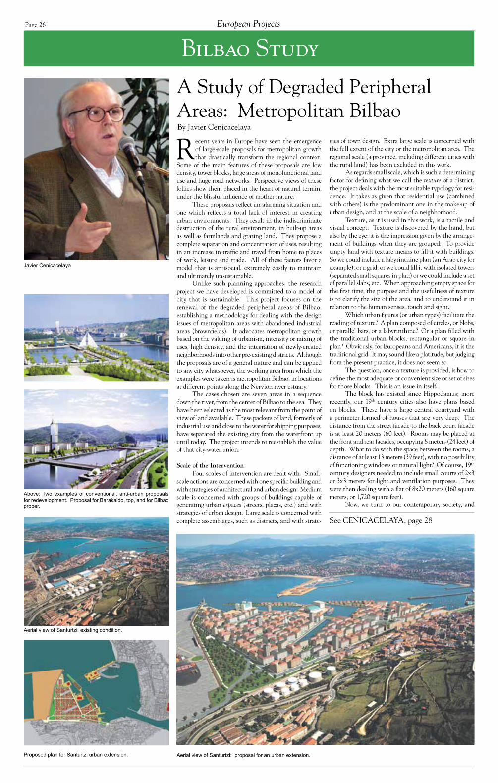
Page 26
Bilbao Study
Javier Cenicacelaya
A Study of Degraded Peripheral Areas: Metropolitan BilbaoBy Javier Cenicacelaya
See CENICACELAYA, page 28
Recent years in Europe have seen the emergence of large-scale proposals for metropolitan growth that drastically transform the regional context.
Some of the main features of these proposals are low density, tower blocks, large areas of monofunctional land use and huge road networks. Perspective views of these follies show them placed in the heart of natural terrain, under the blissful influence of mother nature.
These proposals reflect an alarming situation and one which reflects a total lack of interest in creating urban environments. They result in the indiscriminate destruction of the rural environment, in built-up areas as well as farmlands and grazing land. They propose a complete separation and concentration of uses, resulting in an increase in traffic and travel from home to places of work, leisure and trade. All of these factors favor a model that is antisocial, extremely costly to maintain and ultimately unsustainable.
Unlike such planning approaches, the research project we have developed is committed to a model of city that is sustainable. This project focuses on the renewal of the degraded peripheral areas of Bilbao, establishing a methodology for dealing with the design issues of metropolitan areas with abandoned industrial areas (brownfields). It advocates metropolitan growth based on the valuing of urbanism, intensity or mixing of uses, high density, and the integration of newly-created neighborhoods into other pre-existing districts. Although the proposals are of a general nature and can be applied to any city whatsoever, the working area from which the examples were taken is metropolitan Bilbao, in locations at different points along the Nervion river estuary.
The cases chosen are seven areas in a sequence down the river, from the center of Bilbao to the sea. They have been selected as the most relevant from the point of view of land available. These packets of land, formerly of industrial use and close to the water for shipping purposes, have separated the existing city from the waterfront up until today. The project intends to reestablish the value of that city-water union.
Scale of the InterventionFour scales of intervention are dealt with. Small-
scale actions are concerned with one specific building and with strategies of architectural and urban design. Medium scale is concerned with groups of buildings capable of generating urban espaces (streets, plazas, etc.) and with strategies of urban design. Large scale is concerned with complete assemblages, such as districts, and with strate-
gies of town design. Extra large scale is concerned with the full extent of the city or the metropolitan area. The regional scale (a province, including different cities with the rural land) has been excluded in this work.
As regards small scale, which is such a determining factor for defining what we call the texture of a district, the project deals with the most suitable typology for resi-dence. It takes as given that residential use (combined with others) is the predominant one in the make-up of urban design, and at the scale of a neighborhood.
Texture, as it is used in this work, is a tactile and visual concept. Texture is discovered by the hand, but also by the eye; it is the impression given by the arrange-ment of buildings when they are grouped. To provide empty land with texture means to fill it with buildings. So we could include a labyrinthine plan (an Arab city for example), or a grid, or we could fill it with isolated towers (separated small squares in plan) or we could include a set of parallel slabs, etc. When approaching empty space for the first time, the purpose and the usefulness of texture is to clarify the size of the area, and to understand it in relation to the human senses, touch and sight.
Which urban figures (or urban types) facilitate the reading of texture? A plan composed of circles, or blobs, or parallel bars, or a labyrinthine? Or a plan filled with the traditional urban blocks, rectangular or square in plan? Obviously, for Europeans and Americans, it is the traditional grid. It may sound like a platitude, but judging from the present practice, it does not seem so.
The question, once a texture is provided, is how to define the most adequate or convenient size or set of sizes for those blocks. This is an issue in itself.
The block has existed since Hippodamus; more recently, our 19th century cities also have plans based on blocks. These have a large central courtyard with a perimeter formed of houses that are very deep. The distance from the street facade to the back court facade is at least 20 meters (60 feet). Rooms may be placed at the front and rear facades, occupying 8 meters (24 feet) of depth. What to do with the space between the rooms, a distance of at least 13 meters (39 feet), with no possibility of functioning windows or natural light? Of course, 19th century designers needed to include small courts of 2x3 or 3x3 meters for light and ventilation purposes. They were then dealing with a flat of 8x20 meters (160 square meters, or 1,720 square feet).
Now, we turn to our contemporary society, and
Above: Two examples of conventional, anti-urban proposals for redevelopment. Proposal for Barakaldo, top, and for Bilbao proper.
Aerial view of Santurtzi: proposal for an urban extension.Proposed plan for Santurtzi urban extension.
Aerial view of Santurtzi, existing condition.
European Projects

Page 27Council Report V
All images in this section courtesy of Javier Cenicacelaya, Center for Metropolitan Architecture.
Project Name: Degraded Peripheral Areas Study
Location: Metropolitan Bilbao, Spain, including the following sites:
• Olabeaga/Abandoibarra/Deusto in Bilbao• Zorroza and Cadagua/Burceña (Elorrieta, and Zorrozaurre water-
front in Bilbao and Barakaldo• Blast Furnace/Axpe Dock/Udondo Dock, in Sestao and Erandio• Riverbank between Erandio and Lamiako, in Erandio and Getxo• Port of Santurtzi/Arriluce Wharf in Santurtzi and Getxo• The Abra in Santurtzi and Zierbena
Classification: Brownfield infill redevelopment
Designer: Center for Metropolitan Architecture; Javier Cenicacelaya, president and project organizer
Consultants: Eduardo Berasategui, engineer
Architects: Iñigo Saloña, Aitor Ibañez
Sponsor: Department of Territorial Management, Housing and the Environment, Basque Government
Design Dates: 1999-2000
Status: Proposed design

Page 28
we find:• The dwellings in the market are rarely over 100 square meters (1,075 square feet).• People do not like rooms opening to dark, smelly, tiny interior courts (in, let’s say, a building of eight stories).
So in the 1920s, research was started on the “through dwelling” apartment, hav-ing from the front to the rear facade a dis-tance of 10–12 meters. All the rooms are ventilated with windows to open spaces. The area of the flats is substantially re-duced, to around 100 square meters. This is what we know as a modern dwelling.
The problem comes when this for-mula is associated with the idea that such dwellings inevitably drive the construction of slabs (tall buildings that are narrow rectangles in plan). Slabs when used as texture (parallel slabs) do not generate streets, but when they are grouped, form-ing the perimeter of a rectangle or square, they can. So let’s place the slabs around a court. Let’s recuperate the traditional block by making the perimeter thinner than in the 19th century block. This is the modern way of living: modern dwellings, but traditional urban fabric.
DensityThe project deals with specific
configurations (such as the closed city block: four slabs enclosing a courtyard but not meeting on the corners), heights and ground-floor plans. It includes tables of dimensions for different types of build-ings with an analysis of those producing the greatest density.
We consider the ceiling that is contemplated in prevailing legislation, 75 dwellings per hectare (30 per acre), to be rather low. The project suggests multiply-ing this density by at least 2½, using 200 dwellings per hectare (80 per acre) as a desirable limit.
If we accept that the most suitable dwelling for contemporary living is the through-dwelling, that is, one organized from the street facade to the rear facade, we come up against depths in buildings of 11–13 meters. Adequate light and air for blocks composed of such shallow through-dwellings is guaranteed. There are many extant examples in Bilbao and other places. Cars are placed in underground garages, and green spaces are provided in parks.
We assign 100 square meters per dwelling, a fixed depth to the perimeter, eight stories of height, plus the semi-street and blocks of varying dimensions. After a long series of mathematical simulations, we arrive at the maximum desirable den-sity (which as a matter of fact is not exactly 200 dwellings per hectare, but 190 (77 per acre). And we would require blocks of 40x60 meters.
With these assumptions, it is impos-sible to reach the high densities of Paris or Barcelona. Those cases have blocks with a much wider perimeter. It would, however, be possible to increase that density figure by going higher than nine floors, and with streets narrower than 18 meters (54 feet).
Mixed UsesThe cities we admire most in both
Europe and the United States are those in which uses are mixed to a large extent. The mixing of uses improves the neighbor-hood’s quality of life. How can you speak of quality of life when, from early child-hood, children travel kilometers by bus from home and neighborhood to school? Or when workplaces are all concentrated at one point?
If we create industrial parks (or
“technological parks,” as they are known in Spain), we immediately produce traffic, plus the fragmentation of activities. Cer-tainly some cases have to be considered for a location outside the city. But we should avoid doing so, if possible.
The project proposes including industrial districts in the neighborhood. The workshops can be housed in industrial buildings, in what we could call “high den-sity” buildings with several floors. These buildings would form part of the district’s layout. Large trucks cannot circulate freely in this type of district; they are restricted to certain routes. Traffic noise, and noise in general, is louder than in a low density district. But this goes with the intensity of urban living.
The inclusion of industrial districts in neighborhoods sounds provocative, but it is not. In Bilbao we used to have – and still have a few – blocks with different floors used for different industrial activi-ties: printers, clothes manufacturing, etc. The huge Berlin “mietkaserne” blocks placed industrial activities in the inte-rior of the courts. That also happens in
Barcelona, and many other places. Plus today industries are very clean. We have lost heavy industries in Europe and should work to reverse that trend.
Metropolitan Areas and Their Relation With the Rural Environment
Relations between metropolitan areas and surrounding territories condi-tion the natural environment in a more determined fashion than any other human act. That is, all actions in the natural en-vironment and in the rural environment are related to metropolitan areas. Unsus-tainable situations in the metropolitan environment inevitably have a harmful effect on the natural environment.
The study of the territory’s features should be a primary factor in the reha-bilitation of metropolitan areas, cities and districts. In the case of Bilbao, there are two first-rate features: the river estuary and the surrounding mountains. Apart from allowing navigation and constituting the center line for urban development, the river estuary has become the main element in the metropolitan landscape. The creation of any other axis aimed at
dominating the river denies the interrela-tion between what is natural and what is artificial; it denies the balance between elements of the environment. Human action must be complementary, reinforcing the territorial feature, protecting it, study-ing its limits, boundaries, and, in the case of the river, its banks.
(Referring to Bilbao, I recently wrote in an article for a book on Spanish urban proposals: “Tell me how you are dealing with the river border, and I will tell you the type of city you have in mind.”)
For the river we contemplate a sec-tion with embankments or borders in two steps. A lower step is capable of allowing one to board a boat, and a higher one cre-ates a promenade. The Parisian “rivieres” provide the section. We find it in many other cities of Europe.
As far as the mountains are con-cerned, the Japanese policy of preserving mountains above a certain height seems valid to us. They then can be reserved strictly for leisure purposes. The Japanese do not build on the slopes of hills, find-ing that the land is unstable. The huge
“carpet” of the “continuum” megalopolis of Tokyo, Nagoya, Kyoto, Osaka and Kobe occupies the flat valleys, and in that “con-tinuum” hills emerge, unspoiled. It is quite an extraordinary view.
MethodologyIn all seven study sites, the method-
ology followed is similar.• First: The area is positioned
within the whole of the metropolitan area. The large infrastructure that affects it is defined: the layout of existing transport systems (motorways, railroads, etc.).
• Second: Existing buildings and their infrastructures are identified and conserved. Bilbao’s heritage in these aban-doned wastelands consists of industrial pavilions or warehouses used for river port operations. Very few are now left. If they are in reasonably good condition, they can accept a different use and enjoy popularity because they are well-remembered. This analysis is related to the preservation and creation of identity.
• Third: The area is textured. Although the transport layout shapes the metropolitan skeleton, the extremely
CENICACELAYA, continued from page 26
Analysis of block densities and configurations of perimeter dwelling structures.
important step of texturing or structuring fills said skeleton with regenerated areas. In the examples analyzed, texturing was carried out on the basis of a network of blocks. A different basis could have been used.
• Fourth: The density resulting from this texturing is calculated.
• Fifth: We start to “break” or alter the original texture when the different uses are included. Changes are introduced to adapt to territorial features, to specific vistas, etc.
• Sixth and last step: Those loca-tions requiring more detailed urban design proposals are pinpointed, to bring them into line with the shapes resulting from step #5 and with the layout of existing infrastructure. The need for siting new transport infrastructure may be deduced: bridges, traffic thoroughfares, etc.
ManagementThe last phase of the process having
concluded, it is relevant to analyze the financial costs of implementing the pro-posals and the management arrangements.
This section would include economic and fiscal policies, reclassification of land, phase plans, funding, land development costs, etc. Also included would be the drawing up of necessary building and town planning codes.
The research project performed this analysis on only one of the areas, being more concerned with preliminary con-ceptualization and the process of design. We found the proposal to be feasible. The main costs lay in the correct definition of waterfront borders, which entails very important infrastructural work.
In summary, the research project focuses on strategies directed at the for-malization of the physical city. This in no way implies ignoring the importance of other parallel and essential actions in the political or economic fields. However, it is our view that, after all, the measures necessary to regenerate a degraded area require physical, architectural and urban means to be carried out. To make this proposal possible in Europe, the authori-ties need to acquire a genuine interest in the city. If we can achieve that, we can achieve everything.
European Projects
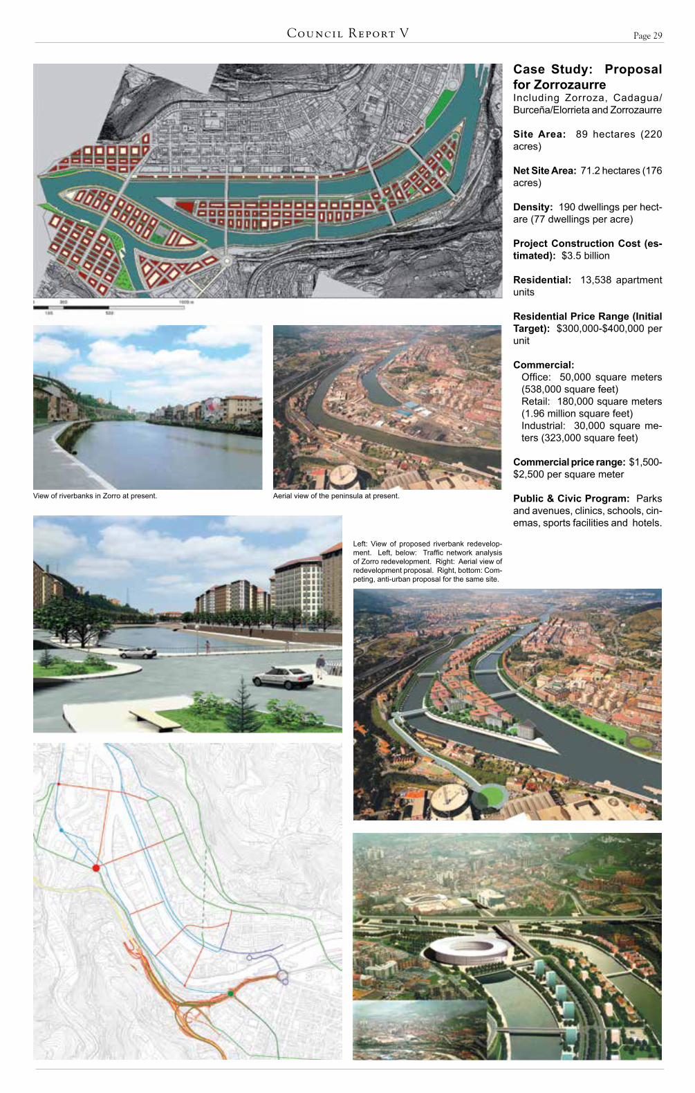
Page 29Council Report V
Case Study: Proposal for Zorrozaurre Including Zorroza, Cadagua/Burceña/Elorrieta and Zorrozaurre
Site Area: 89 hectares (220 acres)
Net Site Area: 71.2 hectares (176 acres)
Density: 190 dwellings per hect-are (77 dwellings per acre)
Project Construction Cost (es-timated): $3.5 billion
Residential: 13,538 apartment units Residential Price Range (Initial Target): $300,000-$400,000 per unit
Commercial: Office: 50,000 square meters (538,000 square feet) Retail: 180,000 square meters (1.96 million square feet)Industrial: 30,000 square me-ters (323,000 square feet)
Commercial price range: $1,500-$2,500 per square meter
Public & Civic Program: Parks and avenues, clinics, schools, cin-emas, sports facilities and hotels.
View of riverbanks in Zorro at present. Aerial view of the peninsula at present.
Left: View of proposed riverbank redevelop-ment. Left, below: Traffic network analysis of Zorro redevelopment. Right: Aerial view of redevelopment proposal. Right, bottom: Com-peting, anti-urban proposal for the same site.

Page 30
FMV Shipyard
Matthew Hardy
FMV Shipyard, Fredrikstad, NorwayINTBAU Summer School, July 2002
By Matthew Hardy and Susan Parham
See HARDY AND PELHAM, page 37
INTBAU’s Scandinavian summer school was held in July 2002 in Fredrikstad in the south of Norway, hosted by Stiftelsen Byens Fornyelse (the Norwegian
Foundation for Urban Renewal). Fredrikstad was the location for the “Fredrikstad Declaration” of February 1998, which bound European local governments to a sustainable environmental program.
The site examined by the participants comprised the large, abandoned FMV shipyard on the island of Kråkeroy, within the Fredrikstad metropolitan area. The island, currently only linked to the mainland by a single high-level opening bridge, contains large areas of low-density, post-war suburban development and provides access to the highly desirable Hvaler islands area further west.
The shipyard site had previously been the subject of a competition won by Norwegian architect Niels Torp. The existing plan placed a number of isolated low-rise apartment blocks in a large, park-like area, accessed by a single curvilinear cul-de-sac. A proposed city center bypass funded by the Norwegian federal government – which would cut the FMV site in two – had been indicated as a high-speed highway in the competition-winning scheme.
However, the size of the site in relation to the city, and its difficult access without the federally-funded bypass, had led the local authority to place a freeze on any development of the site before the construction of a second bridge to the mainland as part of the bypass project. Participants in the summer school produced what was effectively a new urbanist counter-proposal to the Niels Torp scheme.
Following input from architect and INTBAU chair, Robert Adam, and by urban designer and director of The Prince’s Foundation’s Urban Programme, Paul Murrain, the summer school sketch master plan was further developed by consultant urban designers Dr. Mat-thew Hardy, secretary of INTBAU, and Susan Parham, a director of CAG Consultants, with the assistance of architect Arne Sødal of Byens Fornyelse.
Principles Governing the Developed Master Plan
• Long term developmentThe FMV shipyard site represents a very large land
area at the center of a small, slow-growing city. The form of development proposed can be built in stages over a very long period of time.
• Commercial center
The design provides for an intense commercial center with “active frontages” along the bypass road, which in this scheme is treated as a commercial bou-levard. The road and block pattern has been designed to support the creation of an economically viable com-mercial center.
• Waterfront housingThe scheme provides a large component of harbor-
front housing to cater for the local and Oslo housing markets: on a sheltered canal, on south-facing, semi-public harbor-frontages, with long gardens to the north shore, all with privately accessible boat moorings. Our commercial advice indicated that these housing types are particularly saleable in this area.
• Match local densities and heightsThe densities, heights and housing types are se-
lected in response to the urban design potential of the site and to provide a range of alternatives in line with local demography and housing preferences. Housing ranges from harbor-front apartments through tenements, to single-family housing grouped around courtyards or on separate plots. The site offers opportunities to develop a range of sustainable wooden house typologies.
• Development criteria- Maximizing views to the sea- Creating publicly accessible water-edge promenades (located along existing wharf edges)- Creating a centrally located retail node within walk-able distance of the majority of the site- Preserving existing landmark industrial heritage buildings and structures - Preserving vistas along existing crane tracks to the historic ship building cranes- Placing housing blocks to maximize water views to the west and north, and to maximize solar access to the south and west.
• Industrial heritage buildingsThe large industrial heritage buildings are built in
modular bays 22 meters wide, and are thus unlikely to be suitable for housing. We proposed that they be reserved for a range of land uses that could include innovative office developments using ecological design principles. Given their very large size and height, these buildings also create substantial shadows, and the large shaded spaces to the north and east of them are not suitable for housing development.
Details of the Masterplan
Movement, Connectivity and Permeability• The primary movement corridor and intersec-
tions have been located in line with assumptions about the movement economy. The corridor thus responds to the areas where most movement is likely to occur. We would propose that a detail study using Space Syntax analysis be made of the proposed road network to refine
The INTBAU Summer School participants work on the FMV shipyard plan.
European Projects
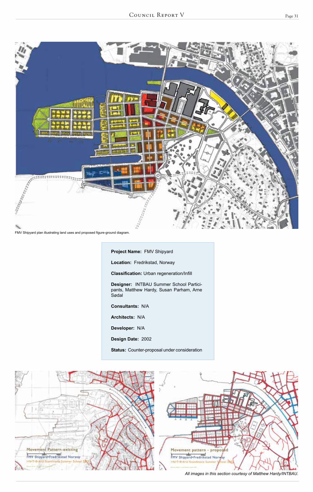
Page 31Council Report V
All images in this section courtesy of Matthew Hardy/INTBAU.
Project Name: FMV Shipyard
Location: Fredrikstad, Norway
Classification: Urban regeneration/Infill
Designer: INTBAU Summer School Partici-pants, Matthew Hardy, Susan Parham, Arne Sødal
Consultants: N/A
Architects: N/A
Developer: N/A
Design Date: 2002
Status: Counter-proposal under consideration
FMV Shipyard plan illustrating land uses and proposed figure-ground diagram.
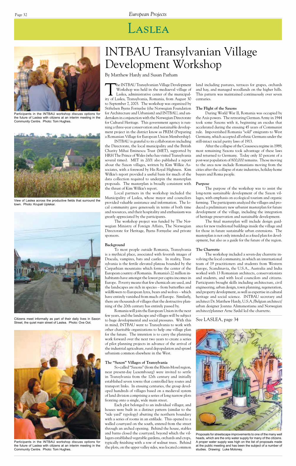
Page 32
Laslea
INTBAU Transylvanian Village Development WorkshopBy Matthew Hardy and Susan Parham
See LASLEA, page 34
The INTBAU Transylvanian Village Development Workshop was held in the mediaeval village of Laslea, administrative center of the municipal-
ity of Laslea, Transylvania, Romania, from August 30 to September 7, 2003. The workshop was organized by Stiftelsen Byens Fornyelse (the Norwegian Foundation for Architecture and Urbanism) and INTBAU, and un-dertaken in conjunction with the Norwegian Directorate for Cultural Heritage. This government agency is run-ning a three-year conservation and sustainable develop-ment project in the district know as PREM (Preparing a Romanian Village for European Union Membership).
INTBAU is grateful to its collaborators including the Directorate, the local municipality and the British Charity Mihai Eminescu Trust (MET), supported by HRH The Prince of Wales (who has visited Transylvania several times). MET in 2001 also published a report about the Saxon villages, written by Kim Wilkie As-sociates, with a foreword by His Royal Highness. Kim Wilkie’s report provided a useful basis for much of the data collection required to underpin the masterplan proposals. The masterplan is broadly consistent with the thrust of Kim Wilkie’s report.
Local partners in the workshop included the Municipality of Laslea, whose mayor and councilors provided valuable assistance and information. The lo-cal community gave generously in terms of both time and resources, and their hospitality and enthusiasm was greatly appreciated by the participants.
The workshop project was funded by The Nor-wegian Ministry of Foreign Affairs, The Norwegian Directorate for Heritage, Byens Fornyelse and private sponsors.
BackgroundTo most people outside Romania, Transylvania
is a mythical place, associated with feverish images of Dracula, vampires, bats and castles. In reality, Tran-sylvania is the fertile elevated plateau bounded by the Carpathian mountains which forms the center of the European country of Romania. Romania’s 22 million in-habitants have amongst the lowest per capita incomes in Europe. Poverty means that few chemicals are used, and the landscapes are rich in species – from butterflies and wildflowers to European lynx, bears and wolves – which have entirely vanished from much of Europe. Similarly, there are thousands of villages that the destructive plan-ning of the 20th century has entirely passed by.
Romania will join the European Union in the next few years, and the landscape and villages will be subject to huge developmental and social pressures. With this in mind, INTBAU went to Transylvania to work with other charitable organizations to help one village plan for the future. The intention is to carry the planning work forward over the next two years to create a series of pilot planning projects in advance of the arrival of the industrial agriculture, rural depopulation and sprawl urbanism common elsewhere in the West.
The “Saxon” Villages of TransylvaniaSo-called “Saxons” (from the Rhein-Mosel region,
near present-day Luxembourg) were invited to settle in Transylvania from the 12th century and initially established seven towns that controlled key routes and transport links. In ensuing centuries, the group devel-oped hundreds of villages based on a medieval system of land division comprising a series of long narrow plots fronting onto a single, wide main street.
Each plot belonged to an individual villager, and houses were built in a distinct pattern (similar to the “side yard” typology) abutting the northern boundary with a series of rooms in an enfilade. This opened to a walled courtyard on the south, entered from the street through an arched opening. Behind the house, stables and barns closed the courtyard, beyond which the vil-lagers established vegetable gardens, orchards and crops, typically finishing with a row of walnut trees. Behind the plots, on the upper valley sides, was located common
land including pastures, terraces for grapes, orchards and hay, and managed woodlands on the higher hills. This pattern was maintained continuously over seven centuries.
The Flight of the SaxonsDuring World War II, Romania was occupied by
the Axis powers. The retreating German Army in 1944 took some Saxons with it, beginning an exodus that accelerated during the ensuing 45 years of Communist rule. Impoverished Romania “sold” emigrants to West Germany, which accepted all ethnic Germans under the still-intact racial purity laws of 1913.
After the collapse of the Ceausescu regime in 1989, most remaining Saxons took advantage of these laws and returned to Germany. Today only 10 percent of a post-war population of 800,000 remains. Those moving to the area now include Romanians moving from the cities after the collapse of state industries, holiday-home buyers and Roma people.
PurposeThe purpose of the workshop was to assist the
long-term sustainable development of the Saxon vil-lages, with emphasis on ecological tourism and organic farming. The participants analyzed the villages and pro-duced a preliminary new urbanist masterplan for future development of the village, including the integration of heritage preservation and sustainable development.
The final masterplan will include design guid-ance for new traditional buildings inside the village and for those in future sustainable urban extensions. The masterplan is not only intended as a fixed plan for devel-opment, but also as a guide for the future of the region.
The CharretteThe workshop included a seven-day charrette in-
volving the local community, in which an international team of 19 practitioners and students from Western Europe, Scandinavia, the U.S.A., Australia and India worked with 13 Romanian architects, conservationists and students, and with local councilors and citizens. Participants brought skills including architecture, civil engineering, urban design, town planning, regeneration, and property development, as well as expertise in cultural heritage and social science. INTBAU secretary and architect Dr. Matthew Hardy, U.S.A./Belgian architect/urban designer Joanna Alimanestianu and Norwegian architect/planner Arne Sødal led the charrette.
Citizens meet informally as part of their daily lives in Saxon Street, the quiet main street of Laslea. Photo: Ove Oot.
Participants in the INTBAU workshop discuss options for the future of Laslea with citizens at an interim meeting in the Community Centre. Photo: Tom Hughes.
Participants in the INTBAU workshop discuss options for the future of Laslea with citizens at an interim meeting in the Community Centre. Photo: Tom Hughes.
View of Laslea across the productive fields that surround the town. Photo: Krupali Uplekar.
Proposals for streetscape improvements to one of the many well heads, which are the only water supply for many of the citizens. A proper water supply was high on the list of proposals made at the public meeting and has been the subject of a number of studies. Drawing: Luke Moloney.
European Projects

Page 33Council Report V
Project Name: INTBAU Transylvanian Village Development Workshop
Location: Laslea, Romania
Classification: Infill and urban extension
Designer: INTBAU workshop participants
Consultants: Susan Parham (CAG Consul-tants, London), Ferenc Csortan (Romanian Ministry of Culture and Religious Affairs) Jes-sica Douglas-Home (Mihai Eminescu Trust), Nat Page and Sarah French (ADEPT Pro-gram), Dorin Boila, Senator Hermann Fabini
Architects: Arne Sødal, Joanna Alimanes-tianu, Matthew Hardy (team leaders)
Developer: Comune of Laslea
Design Date: 2003
Status: Masterplan design
Site Area: N/A
Residential: 92 unitsHouses: 40Rowhouses: 40 (side-yard typology to match existing)Apartments: 12 (renovation of existing building)Live/Work Units: 80 (all houses new and existing in Laslea are live-work)
Commercial: 300 square meters of office and retail
Public & Civic Program: New public market, youth center, building information and training center and public baths. Improvements to water supply and drainage. Renovations to public parks and streets. Flood mitigation work and environmental improvement of streams.
Above: The beautiful fortified high Gothic church in Malancrav, one of the five villages making up the Comune (Municipality) of Laslea. Photo: Krupali Uplekar.
Right: Sections through the village showing typical Saxon land use patterns. Drawing by Marius Sandu.
Left: Plan for the creation of a public square in front of the main church.

Page 34
Workshop ComponentsThe workshop comprised a series of
elements intended to inform the partici-pants about key aspects of the region, its history, people and architecture. These included: Tours of the region’s architecture of Saxon houses and fortified churches with expert commentary from Romanian specialists; Visits to fortified churches and to Saxon houses renovated by the MET with William Blacker, Caroline Fernolend and Mihai Cazan, and to a model farm dem-onstrating sustainable “micro-farming” techniques managed by Wolfgang Rad-datz and farmed by Daniel Credu for the PREM project.
A range of lectures and briefings included:The theory of new urbanism in a Eu-ropean context, by Matthew Hardy and Joanna Alimanestianu; Planning in the region by architect Dorin Boila; The history of Transylvania by Francisc Csortan of the Romanian Ministry of Culture and Religious Affairs; The ADEPT programme, by Nat Page and Sarah French;The proposal to establish a protected area by Jessica Douglas-Home of the MET; The Saxon churches of Transylvania by Senator Hermann Fabini.
Public ConsultationThere was an extensive public con-
sultation program as part of the workshop, which was based in the Caminul Cultural (Cultural Centre) in the heart of the vil-lage, allowing citizens to drop in at any time. More formal events included:
An evening public meeting at-tended by the mayor, Councilors and 140 citizens of Laslea, to hear from the community about local issues, problems and ideas for the future;
An informal presentation of “work in progress” to receive feedback from the community on draft proposals, attended by around 30 residents;
A public exhibition on the final evening of the workshop to present the proposed masterplan and supporting documentation and listen to community views.
During the workshop a question-naire on attitudes to cultural heritage, commissioned by the Norwegian Direc-torate for Cultural Heritage, was con-ducted by participants under the direction of London-based planner/urban designer Susan Parham, assisted by Terje Nypan of the Directorate. The results influenced the overall design masterplan.
Data CollectionParticipants collected a wealth of
data about the community of Laslea, including:Landscape ecology and climate;Cultural heritage;Urban fabric (housing and other built form typologies);Services and facilities;Infrastructure (especially the key issue of water supply);Transport and access;Human activities including enterprises and employment, notably in traditional agriculture;Population profile and village identity issues; and Governance, planning and taxation structure.
MasterplanThe masterplan produced by the
participants included the following key proposals:
LandscapesAn existing proposal for a conserva-tion zone including the Saxon build-ings, should be extended to the edge of the woodland surrounding the village, encompassing the streetscapes, houses, barns, vegetable gardens, and farm land comprising the cultural landscape. A biodiversity corridor and linear park should be developed along the river system.The remnant pedestrian path network, including portions along the river system and on back alleys, should be redeveloped and new paths built, all simply marked and mapped to promote walking tourism.
Houses and Streets There are a number of households without shelter or suffering from very poor housing conditions. Houses that are not yet connected to gas, electricity and water should be connected as soon as possible.Assistance and training should be given to those in need of housing to meet their housing requirements. The masterplan shows proposals for new housing areas in northern and south-ern areas of the village to accommodate current population growth.Traditional housing typologies should be protected and maintained by use of traditional materials and renovation techniques. Traditional streetscapes should be protected and enhanced through street tree planting and measures to slow traffic.
Services and Facilities Low-impact ecological drainage and sewage systems should be installed, with common service trenching used when
introducing improvements. Public baths should be developed close to the dispensary. A youth center should be developed at the old cinema next to the Caminul Cultural. New pedestrian bridges should be developed at points shown on the mas-terplan. Petrol pumps should be located in a low-key manner at the center of the village.
Nodes of ActivityExisting nodes of activity within the village that are supported by walkable catchments should be supported and re-inforced by new activities as appropriate. A simple pubic market structure is proposed near the key intersection of the two main streets, close to the river, café and general store.
Urban InfillThree sites to the west, east and north within the village, found suitable for mixed-use development, are shown on the masterplan. The balance between housing and other uses will vary as ap-propriate. The vacant site on the main street should be developed as a civic building to maintain the traditional building line and to close the vista termination at the junction.
Urban Expansion Participants proposed developing re-maining fields within the village before developing outside. Three areas identified for sustainable urban extensions within walking distance of existing facilities are shown on the masterplan. Few citizens of Laslea own cars.Local Enterprise and Tourism
There is potential for local enterprises such as the village grain mill to be en-couraged and expanded. Ecotourism projects including guest-houses and micro-farms should be sup-ported and encouraged within the exist-ing urban fabric. A current proposal for a chain of guesthouses in the deserted priest’s houses in Laslea and adjoining villages should be encouraged, with a tourism information center located at the general store. A center for building construction information and skills training should be developed in a central location within the village. An internet facility could simply be pro-vided at the library, general store or café rather than relying on a public terminal.
More information can be found on the web site: www.intbau.org/Transylvania.htm
An elderly citizen of Laslea makes a point at the first public meeting in the Community Center. Photo: Tom Hughes.
B i r d ’ s - e y e v i e w o f t h e n o r t h e r n v i l l a g e e x t e n s i o n , p r e s e r v i n g a n d incorporat ing an exis i t ing informal set t lement. Drawing: Robert Patzschke.
Study drawing of movement networks in the village. Very few citizens own cars, and most daily activity is within walking distance. A network of paths leads from the village to the common agricultural lands beyond.
Participants in the INTBAU workshop discuss options for the future of Laslea with citizens at an interim meeting in the Community Center. Photo: Tom Hughes.
LASLEA, from page 32
European Projects

Page 35Council Report V
areas (courtyards in housing blocks, parking garages) and private areas (small gardens for bottom floor apartments, terraces, apartments, offices). Outdoor movement is concentrated on the streets, with separate pavement and curbstone parking. Your car is either in safe custody in the garage or within view of your apartment. Parking areas are small and many, instead of few and large, and some have dual usage, by working people during business hours and residents the rest of the time.
Entrances to apartments and yards face the streets. People on the lower floors have small private gardens with patios. In the middle of the blocks are courtyards with common space for play and social intercourse. These secure yards are to the advantage of children; kitchens face the jointly used space, creating safety for children. Many of the houses have a private forecourt facing the street. Most living rooms face the streets, lighting up the public area at night when rooms are lit and television sets are on.
There is a mix of detached houses, semi-detached houses, terraced houses and apartment blocks. Around every courtyard there is a maximum of 40 flats, and flats within each block have different sizes to allow a mixture of age groups and housing categories. A rule of thumb has been that houses shouldn’t be higher than the crowns of the trees, as high houses make the neigh-borhood windy. The average number of floors is three. Low houses, courtyards surrounded by buildings, closed street rooms and plenty of vegetation create a good lo-cal climate and improve security, homeliness and social control. The distance between the buildings facilitates eye contact. You can say hello to your neighbor in the house just opposite.
Today, apartment houses are being built close to the water and along a pier out in the lake, with a restaurant and an old lighthouse constructed by the former Järla inventor and industrialist, Gustaf Dahlén. A large restaurant with a gym at the entrance, together with small shops in a kiosk, a bakery, the bowling saloon and the furniture store, make the area more than just a housing/employment project. It has become a place with many reasons to visit.
The Järla Sjö project has attracted unusually high attention in the media and is seen as one of the model projects of the Nacka municipality. The added value of historical buildings, preserved trees and monuments (such as the restored brick smoke stack) is reflected by the generally high prices of apartments and office space oc-cupation – despite the present economic recession with an excess of empty office buildings. The area is marketed as a small town with the slogan “liv, lust, gemenskap” (life, joy, community). It is sometimes seen as a part of the Södermalm inner city area that today is perhaps the most creative part of Stockholm, transforming from a working class area to a place for the young, hip, genuine and still-not-too-wealthy. From a residents’ point of view, the numerous visitors and overcrowded jetties in the summer creates a popularity problem.
The major architectural journal of Sweden, Arki-tektur, has up until now decided not to review Järla – the lack of “refinement” in its sometimes rather plain and informally varied architecture doesn’t qualify for cover-age. As some modernists might say, the roofs are not flat; thus this can not be an architecture “of our times.” But built it is. Right now. Back to the Future – Made in Sweden.
Weaknesses Only one architectural company designing all apart-
ments/housing. But more housing architects will be contracted.
Only one entrance, only one road connection, re-ducing the public realm and opportunities for real city life, shops, meeting places (which might change, see text).
Only a few housing companies. But the number is increasing.
No apartment houses (ownership only) – due to Swedish political policy.
Apartment blocks a little too open for visitors, reducing the feeling of privacy/community.
Strengths Good balance of new and old buildings, work, living
and retail. High degree of preservation of historical buildings
and traces in the ground/vegetation. In due time a rather high level of activities generat-
ing visitors, apart from living/working.A number of public spaces with different possible
uses and attractions. Different rental levels, creating economic space for
both high and less yielding companies. Small-scale and low buildings offering the same
density as the first large-scale project. Integrated parking along streets – almost a “crime”
in previous Swedish planning.
Gustaf de Lavals Square. The main square with the old Turbine Hall to the right.
Different proposals for the site, showing changes in planning concepts over the years.
development of the neighborhood. That has proven to be very successful during the last 10 years, especially because the administrative process for the adaptations has been greatly streamlined.
The master plan of the neighborhood keeps indications of the industrial history of the site (the “genius loci”) through the massing and the orientation of the buildings, and the detailing of the public spaces.
There is a close mix of industrial activity with housing, commercial and civic programs. It shows how today, a quite heavy industry no longer needs to be pushed away from the city because of nuisances. (Still, the value of land is getting so high, that unless zoning is kept as industrial, there is a strong pressure to move industries to the suburbs.)
On the other side, some points may need to be improved:
Even though there is a good mix of uses within the area of the project (although some more housing
ANDERSEN, continued from page 14
would have been desirable), each plot remains more or less single-use, more a juxtaposition of uses than real blending. Nevertheless, the guidelines ask for a more public orientation for residential projects bordering the main road, which allows, for instance, housing above restaurants or other public activities.
The city has a hard time ensuring that enough housing is built, even though the ratio of housing has been made mandatory through the planning process. Right now, the development of office space is much greater than the construction of new dwellings. That situation is about to change, however, as a housing project of 22,000 square meters is in process.
Even though the amount and location of the public plazas and greens have been determined through comprehensive planning, no guidelines have been pre-pared to ensure the coherence of these public spaces throughout the entire site. This is about to be corrected as the city prepares citywide guidelines for the design of
public spaces. The main road passing through the develop-
ment area is under the authority of the canton (more or less the equivalent of a state in the United States), and it has recently been widened to become one of the main access routes to the city. The size of the road and its design correspond to guidelines that are defined at the level of the canton’s authority; it has not been possible to adapt these requirements to the scale and design of this neighborhood.
Endnote1 Bureau UR, “Baden Nord: ABB Real Estate Ltd develops a new city
district,” Baden, 2001
SÖDERLIND, continued from page 18

Page 36
the plan has been executed does the architect begins to design. However, if people are to be convinced, many steps have to take place in parallel. It was unusual that in this project simultaneous engineering took place. Urban designers, landscape planners, architects and civil engineers worked together with economists and advertising and marketing consultants. Thus Brandevoort is the result of a new planning culture that focuses on the citizen.
The building, development and marketing of the houses were taken over by Bouwfonds Eindhoven and De Compagnie Brandevoort, a merger between several local building enter-prises. In their planning, both followed to the letter the image quality plan drawn up by the team of master planners.
The hope that this newly founded town would not be laden with the stigma of “stale novelty” has been miraculously fulfilled. Although Brandevoort is barely half finished, it prom-ises to become urban in character. This expectation is height-ened when one comes to know the residents personally; their decision to settle here is bound up with the desire to participate in the adventure of founding such a town.
Endnotes1 City expansion locations following the “Vierde Nota Ruimtelijke Ordening
Extra,” issued in 1993 by the Ministry of VROM.2 Hans van Rossum, Frank van Wijk, Lodewijk Baljon, De stad in uitersten –
Verkenningstocht naar Vinex-land, Rotterdam 2001.3 Frank Bertolt Raith, Lars Hertelt and Rob van Gool, Inszenierte Architektur:
Wohnungsbau jenseits des Standards, Munich 2003.
Renderings of Brandevoort in the de-sign stage. Top: A circular plaza at the outer wall of the town center. Middle: A church is the focal point of a main view axis. Right: A narrow, tree-lined street. Below, left: The covered market as seen from the canal. Below, right: Lateral facades line a main street with a market at the terminating point.
Page left: Photos of townhouses lining the canal in Brandevoort’s town center.
KOHL, continued from page 24
European Projects

Page 37Council Report V
the movement pattern to reinforce the retail center.• In summer, a large number of commuters travel
between Oslo and the Hvaler Islands beyond Fredriks-tad. This movement is perceived by townspeople as a problem, creating traffic congestion in the Fredrikstad city center. We believe that these traffic flows also pro-vide a great opportunity to activate commercial uses on the FMV site in the long term when a proposed linking bridge and road are built. However, plans for the FMV site cannot assume the existence of this bridge in the near future. Accordingly, the road network has been designed to allow for movement during the initial phase with ac-cess from the west only, and for north-south movement in the future when the road and bridge links are built. The road layout has been designed to maximize permeability and connect more closely to the regional, subregional and local road network, allowing for a range of future possibilities.
• The bridge link is proposed to be in the loca-tion envisaged in the Norwegian government proposal, but we propose a low-level bridge with a lifting central section to allow the creation of a ground-level boulevard through the site, with active frontages adjoining the ex-isting buildings on the northern waterfront. This move also improves the potential for connection of the site’s street network to the subregional network to the south. As well as contributing to overall connectivity and leg-ibility, it also provides the opportunity to create a street with active uses on both sides – vital for a functioning town center.
• In order to support retail viability and pedestri-anization, more access points have been created along the main active street frontages. Greater permeability in this area is important to the economic and social vitality of the center.
• New roads have been at widths in line with traditional urban road dimensions in Fredrikstad. The building typologies proposed will create appropriate height-to-width ratios on all streets.
• The movement network has been designed to allow a reasonable degree of vehicular permeability and legibility while retaining a pedestrian-oriented prom-enade at the water’s edge.
• A ferry stop has been proposed in a location accessible from the existing service running along the river.
• The proposed road network allows the potential to create one or more bus routes through the redeveloped area.
Housing and Other Land Uses – Block Sizes and Density• Small plot sizes – both retail and residential –
have been proposed, especially in and around the center, to promote a fine grain and high intensity of active uses, and to allow sites small enough to permit small and medium sized local housing contractors to work on the site, rather than single large contractors for wide areas.
• Plot sizes have been based on the need to promote a variety of timber-framed house typologies on site. Plots are now of appropriate size to accommodate a range of sizes and styles of housing based on a realistic commercial assessment of both local and Oslo housing markets.
• Specific locations, grain, scale and densities for mixed use have been developed including retaining a proposed school and relocation of the FMV football oval to integrate with that development.
• The overall density of the site has been arranged to match the urbanity, vitality and economic viability of the existing city center, rather than the surrounding low-density post-war suburbs.
• Service, commercial and industrial land uses including small scale boatyards and associated uses have been proposed in locations shaded in winter by the exist-ing cliff face.
Existing Heritage and Other Buildings• The road layout and block pattern, and the site
density and land use patterns, have been designed around existing heritage industrial buildings to create landmarks or vista termination points in the urban design scheme.
• Other existing buildings that house existing economic uses or present the possibility of economic use in future have been retained in the design.
Access to Water• A canal is proposed to provide opportunities for
boat mooring associated with individual dwellings, im-proving amenity provision and increasing the desirability
of this housing and the viability of the development. The plan maximizes the quantity of harbor-frontage housing with private boat moorings.
• A continuous promenade is proposed at the water’s edge where existing wharf edges make this pos-sible. Existing unconsolidated water frontages have been allocated to private waterfront housing.
• Promenades and harbor-frontages have been placed on the desirable southern and western frontages wherever possible.
Harbor Frontages and Green Spaces • Existing spontaneous plantations of exotic
species arising from ballast deposits have been retained within the development.
Staging of the Development• Redevelopment is proposed to be staged to allow
establishment of the central part of the site before the construction of the federally-funded bypass and bridge. Development of the more remote northern and western areas is assumed to become possible only with construc-tion of one or more of the north-south road links.
• The center has been placed to reflect staging possibilities related to the changes in site access over time.
Development Typologies and CodingIt is intended at a future stage of development to
code the FMV site as a wood-framed city for reasons of sustainability and in line with Norwegian national policy on timber use. Use of timber can be justified not only on the grounds of sustainability but in order to relate to the history of the use of timber for housing in the area and the site’s own history as a local industry connected to timber. In addition, wooden buildings are highly
portable and allow for removal and replacement by more intensive development in the distant future without high demolition costs and waste of resources.
Fredrikstad Regional Strategy – LinkagesWe argued that the site constitutes a major strate-
gic land asset for Fredrikstad. The general plan currently allows for development of a number of greenfields areas at some distance from central Fredrikstad, which we believe would undermine successful use of the FMV site.
• First, greenfield development where brownfields are left undeveloped cannot be justified on grounds of sustainability, which is best achieved by a more compact, contiguous urban form.
• Second, we assume that substantial infrastruc-ture costs would be associated with development of these zoned areas for future housing as they are distant from existing urban edges and infrastructure connections.
• Third, their distance from the urban center means they would be difficult to serve with public trans-port, making them inherently car-dependent.
• Fourth, the development of peripheral green-fields would undermine the economic viability of the site, thus wasting a key opportunity for urban regeneration.
We proposed to the local authority that they should consider freezing the proposed peripheral green-fields shown on the general plan as future housing. In-stead, a strong green belt should be created around the built-up area so as to locate as much new development as possible on internal areas such as the FMV shipyard site.
The report and drawings were presented to the site owners and municipality in early 2003 to an enthusiastic response. We await a decision on the future direction of planning on this site.
HARDY AND PELHAM, from page 30

Page 38
ALIMANESTIANU, from page 16
European Projects
Above: Panorama of site before construction. Below: Panorama from the same vantage point after constuction is completed. Photos courtesy Fortis A.G.
Seating area and pavillion in central garden. Photo: Daniel Bruynseels.
View of lot 5 from the central garden. Photo: Liam O’Conner.
street. It was the unity of style, but also the subtle differ-ences between the Spanish, the English, the Italian, the French and the Belgian, that brought the street to life and made it feel like it had always been there.
One contestant pointed out that there were vacant buildings on the site that should be preserved. There was one we actually reconstructed reusing the original timber framing. We also respectfully worked around a ‘50s or ‘60s townhouse of yellow brick and horizontal windows – the owner did not want to sell, and he was probably right! There was a drugstore on site that A.G. bought, demolished, rebuilt and then rented back to the proprietor. We worked individually with the different owners trying to solve their needs and restore dignity to the street, the block, the neighborhood.
Although the townhouses were separate structures above grade, the parking would be one contiguous under-ground garage with an entrance and exit on the minor street, rue du Cirque. Car access was through a sculpted porte-cochere and wonderful courtyard before descending below grade. Pedestrian access was also carefully studied: through stairs with a caryatid, courtyard leading to the sidewalk, and then to the front doors. We often heard the question “Why no elevators directly from the parking to the residences – what about the rain?” We were convinced that for vibrant city life, people must be encouraged to walk along the street. We did reconsider the need for elevators but decided the expense was unwarranted in five-story buildings. We knew there were better ways to spend the money!
We made two exceptions, putting elevators in the corner buildings for the older or disabled residents who could enjoy the city views better from these corner homes. Eliminating elevators did raise the question of how to get groceries, luggage, etc., up to the fifth floors. We simply put in dumbwaiters in all the other buildings.
While the housing was being solved, I was design-ing the office building with my team, trying to tactfully collaborate with the modernist architect, Les Architectes Polak, who had been working on it for years!
Politics and the MarketWe involved the local neighborhood committee,
sharing information and getting their opinions. We also worked closely with the city, keeping them involved throughout the process. The Boguemister of downtown Brussels was a particularly colorful character, formerly a bouncer of a local nightclub. It certainly couldn’t hurt his image to be seen as supporting our work that was very quickly attracting a lot of press – even Prince Charles was interested, visiting the project twice. To encourage the Boguemister we actually appointed him president of the jury!
Real estate agents were telling us, “There’s no mar-ket for housing down here. People are leaving the city center for the suburbs (at least the Belgians are), and surely families don’t want to live here; just build small flats for foreigners or transient bachelors, invest very little – you’ll never get your money back.”
Lasserre and I listened, but we had a gut feeling this wasn’t quite right. On the contrary, we had to do quality, we needed to provide basic housing that felt like it always belonged there and even more – large, well designed homes that would attract people to stay for a long time.
This was also important for the Boguemister because
he needed votes. He wanted long-term residents, not transients. We kept him constantly updated with information, plans, drawings, and it became an inside joke: “We’ll send Joanna over there, he remembers her because of her long hair.” (I did have very long hair at the time.) Of course it helped move things along, but it still took ages to get the building permit.
We came across a lot of resistance. Ar-chitects, developers, even city officials did not understand things such as the pleasures of walk-ing down a street, townhouses with different designs or expenditures for traditional details. We were told: “You’re being totally unrealistic; no one but a rich insurance company can build like this. If you really want to do something worthwhile, provide an example of great residences in one huge building, cheap and easy to build.”
But we continued our way.The central park was planted and flourishing before
the buildings were finished. I am proud that I choose the landscape architect, Dan Kiley – a real humanist and wonderfully talented designer. So although he had been working in a modernist mode, he appreciated what we were doing and created a haven people enjoy more and more as it matures.
ConstructionThe new 18,000-square-meter office building that
replaced the 12-story corner tower was tricky to build. A.G. wanted to keep its employees on-site throughout the process. I devised a phased scheme: Build both wings up to the corner tower, then move everyone out of the tower into these new wings, demolish the tower, and in its place connect the two wings, creating one large, continuous (A.G. requirement!) floor plate.
With my small team I then designed the building, continuously feeding Les Architectes Polak drawings – the facades, the plans, down to all the built-ins, the door handles, the signage … meticulously correcting their bid and construction sets before they went out. They resisted at first (they were modernists after all), but we managed to convince them that traditional design was more than feasible.
Simultaneously, the seven architects of the town-houses along the rue de Laeken were developing traditional designs and specifying traditional materials. My role was to represent the owner, to make sure the designs were marketable, the layouts convenient, etc. The person who really pulled it all together was Olivier De Mot, a partner of Atlante Architects, preparing the bid sets and supervising construction of the different designs, and doing this in the most smooth and cost-effective manner.
While all this designing was going on, the A.G. real estate department kept us within a high but nonetheless middle-range budget. We all agreed to this challenge, we succeeded and even more: The housing looks and feels like luxury dwellings!
Conclusion & EvaluationRue de Laeken certainly had an impact in the
architectural sphere, changing attitudes about what was possible in Brussels. But that change has not really reached the layman or the developers. One, the successes of the project were not publicized enough. Two, the weakness of
the project is very blatant: continuously empty storefronts. Lasserre’s theory is that if stores are not leased before construction is finished, they probably will never be suc-cessful. Lasserre had the unfortunate (for the project) idea of leaving A.G. before making sure this happened! As a result now, eight years later, only one shop is rented, to a florist who has been there from the start. All the others are currently empty. The company says there is no market for small shops, that they were forced to include retail by the city and that it was a bad idea from the very start. The fact is that A.G. did not take on the challenge. Perhaps we are also to blame: We simply didn’t communicate our beliefs, our enthusiasm, in a way that the company could adopt our determination for success.
There were other mistakes. We should have encour-aged retail on the other side of the Rue de Laeken even though it didn’t belong to A.G. We should have realized that if both sides of a street aren’t developed simultane-ously, a street isn’t really a street. Also, the sidewalks should have been widened and the street width reduced.
While redeveloping a messy lot such as this, it is important to be aware of the qualities that make Brussels a wonderful city to live in, to work in, to just be in. Let the wonderful aspects of a city be an inspiration and then carry on that tradition. Though we were open to advice, we also knew when to ignore “professional” recommendations based on backwards-looking statistics and preconceived ideas. The success of this project probably lies in the fact that we persisted on the course that felt right to us.
The residential row as seen from the central courtyard. Photo courtesy Fortis A.G.

Page 39Council Report V
The material contained in this presentation has been drawn from the hundreds of projects de- signed by Duany Plater-Zyberk & Company over
the past twenty years. The goal was to assemble a number of DPZ’s contributions to the collective knowledge of the new urbanism and present them as a set of useful tools.
This article focuses on the algorithms, or step-by-step techniques for solving urban design problems. They are derived from empirical knowledge of what has and hasn’t worked throughout history. By presenting some examples of successful algorithms that have been employed by DPZ, we hope to continue to improve and refine the practice of urban design.
Some of these techniques are rational and objec-tive; others may seem quite subjective, exotic or “baroque” in nature. There are two sides to urban design. On the one hand, it is a rational activity, based on logical principles that guide the construction of human settle-ments. But it may also go beyond the utilitarian demands for shelter, serving to address common aesthetic and spiritual values. Then it becomes a civic art, informed by the specific choices and combinations of techniques and historical precedents. Thus, urban design can be considered the science of building places that work and the art of creating places that feel good. It is critical that its practitioners be fluent in both approaches, that they possess a diverse repertoire of tools and techniques. This presentation seeks to demonstrate that urban design can be studied, analyzed and learned, both as a science and as a civic art.
* * *(Figure 1) The first technique we will discuss is
step-by-step regional master planning, using the ex-ample of Northwest Hillsborough County, Fla.
The process begins with an analysis of the existing conditions. This site has been subject to active suburban-ization for nearly 40 years. The negative consequences of this pattern include segregated housing enclaves, a cul-de-sac and collector road system, the absence of work-places to balance the residential development, lengthy commuting, and a disconnected and not systematically secured open space.
The image to the left shows the present land occupation of piecemeal development and the discon-tinuous thoroughfare system, which together result in an inefficient use of land, traffic congestion, and wasted natural resources. The image to the right effectively illustrates the consequences of sprawl by providing a generalized representation of present (the lighter circles) and projected (the darker circles) areas of development. The projected population for 2020 is 39,000 people. Under current development patterns, which average 3 housing units per acre, the new residents will consume
an additional 5,300 acres. (Figure 2) The methodology used to allocate future
growth in Northwest Hillsborough County is the Rural Boundary Model. It involves the following sequence:
Step 1. Delineation of the Preserves, which cover large-scale ecosystems that are to remain free of de-velopment in perpetuity, and the Reserves, which are envisioned for agricultural use or very low density devel-opment. The Reserves will transfer Development Rights for higher density to areas designated by the master plan.
Step 2. Creation of a comprehensive system of Open Space Preserves after the Transfer of Development Rights from the designated Reserves.
Step 3. Allocation of urban growth in the form of traditional neighborhoods (TNDs) and town centers (transit-oriented developments, or TODs).
(Figure 3) This drawing shows the areas intended
for incentivized development or redevelopment. These areas are preapproved by the county, allowing developers to avoid the complicated and burdensome process cur-rently required to gain building rights. The darker circles represent town centers, or TODs, which are slated for the densest development. TODs usually occur at existing malls or shopping centers that are well-positioned for transit, near light rail lines or major intersections. The lighter circles show the preferred areas for the construc-tion of new TNDs or the redevelopment of existing ones.
The last map is a composite view, showing the finalized system of Preserves, TNDs and TODs together.
A necessary continuation of a regional plan is the development of a series of typical conditions that may be used as models for future projects. A sequence of these is following.
Citrus Park Village is a retrofit of an existing neighborhood. Its sparse but well-defined grid is expand-ed to achieve connectivity with the surrounding areas and the open space. The proposed vehicular network is more rectilinear and urban at the center, becoming more organic towards the edges. Squares, parks, greenways and trails are arranged in a system of open spaces. The extremely porous character of the plan ensures pedestrian accessibility to all natural areas and civic places.
A second retrofit model is a strip shopping center at a typical suburban intersection. The currently approved plan consists of a supermarket, shops and office buildings, with a large parking lot in the front and no connections to the adjacent residential neighborhood. The proposed alternatives to the existing site plan relocate buildings to mask the parking and to define the corner between the highway and the road.
The strategies used to retrofit a conventional sub-division into a sustainable neighborhood may include the conversion of the entry collector into a main street lined with mixed-use buildings, the creation of a neighborhood square with a meeting hall terminating the main street, and the addition of new connecting streets. In certain situations, there is little incentive for developers to effect such a transformation, except in the event of collapsing property values in a subdivision as it ages.
(Figure 4) This rendering illustrates the existing entry condition of a typical suburban subdivision. (Fig-ure 5) Transformed, it can become the beginning of a main street. Two pairs of mixed-use buildings replace the houses on each side, facing the street and forming plazas. Parking, while still conveniently accessible, is hidden behind the buildings.
The second phase of the Northwest Hillsborough County Master Plan involved a detailed Regulating Plan,
based on specific property lines. Two of the included projects are highlighted below.
(Figure 6) One of the designated town centers is located on a busy highway. Embracing both sides of the
road, it features a supermarket, high-density residential, offices, and shops. The urbanism is compact with clearly defined edges, preserving the environmentally sensitive area to the north. The fabric consists of perimeter blocks containing surface and structured parking in the interi-ors. To the south, new blocks are seamlessly connected to the existing fabric and form a range of public spaces.
(Figure 7) The retrofit of a mall is a common way to
accommodate a town center at a good location and with the necessary services. The Citrus Park mall was recently built and is still very successful. Therefore, rather than having it demolished, the proposal makes it an integral part of the fabric of the town center.
Historical precedents in urban design can be local or universal. Since it was difficult to find a relevant local precedent for a town center in Hillsborough County, the team used a universal precedent: the medieval village. The mall’s picturesquely designed main spine was kept and opened as a pedestrian passage. A street was carved out through the mall in north-south direction, and the parking lot was subdivided into blocks with structured
Advanced Techniques in Urban DesignBy Galina Tahchieva Images by Duany Plater-Zyberk & Company
Figure 8
Figure 7
Figure 6
Figure 5
Figure 4
Figure 3
Figure 2
Figure 1
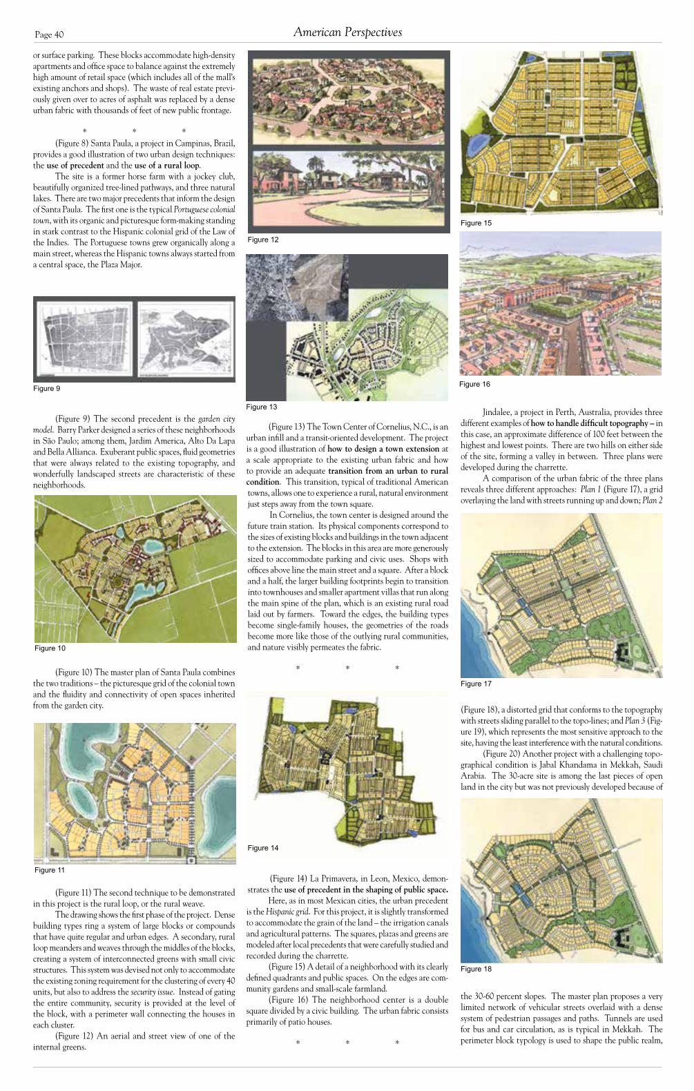
Page 40
(Figure 13) The Town Center of Cornelius, N.C., is an urban infill and a transit-oriented development. The project is a good illustration of how to design a town extension at a scale appropriate to the existing urban fabric and how to provide an adequate transition from an urban to rural condition. This transition, typical of traditional American towns, allows one to experience a rural, natural environment just steps away from the town square.
In Cornelius, the town center is designed around the future train station. Its physical components correspond to the sizes of existing blocks and buildings in the town adjacent to the extension. The blocks in this area are more generously sized to accommodate parking and civic uses. Shops with offices above line the main street and a square. After a block and a half, the larger building footprints begin to transition into townhouses and smaller apartment villas that run along the main spine of the plan, which is an existing rural road laid out by farmers. Toward the edges, the building types become single-family houses, the geometries of the roads become more like those of the outlying rural communities, and nature visibly permeates the fabric.
* * *
(Figure 14) La Primavera, in Leon, Mexico, demon-strates the use of precedent in the shaping of public space.
Here, as in most Mexican cities, the urban precedent is the Hispanic grid. For this project, it is slightly transformed to accommodate the grain of the land – the irrigation canals and agricultural patterns. The squares, plazas and greens are modeled after local precedents that were carefully studied and recorded during the charrette.
(Figure 15) A detail of a neighborhood with its clearly defined quadrants and public spaces. On the edges are com-munity gardens and small-scale farmland.
(Figure 16) The neighborhood center is a double square divided by a civic building. The urban fabric consists primarily of patio houses.
* * *
Figure 14
or surface parking. These blocks accommodate high-density apartments and office space to balance against the extremely high amount of retail space (which includes all of the mall’s existing anchors and shops). The waste of real estate previ-ously given over to acres of asphalt was replaced by a dense urban fabric with thousands of feet of new public frontage.
* * *(Figure 8) Santa Paula, a project in Campinas, Brazil,
provides a good illustration of two urban design techniques: the use of precedent and the use of a rural loop.
The site is a former horse farm with a jockey club, beautifully organized tree-lined pathways, and three natural lakes. There are two major precedents that inform the design of Santa Paula. The first one is the typical Portuguese colonial town, with its organic and picturesque form-making standing in stark contrast to the Hispanic colonial grid of the Law of the Indies. The Portuguese towns grew organically along a main street, whereas the Hispanic towns always started from a central space, the Plaza Major.
(Figure 9) The second precedent is the garden city model. Barry Parker designed a series of these neighborhoods in São Paulo; among them, Jardim America, Alto Da Lapa and Bella Allianca. Exuberant public spaces, fluid geometries that were always related to the existing topography, and wonderfully landscaped streets are characteristic of these neighborhoods.
(Figure 10) The master plan of Santa Paula combines the two traditions – the picturesque grid of the colonial town and the fluidity and connectivity of open spaces inherited from the garden city.
(Figure 11) The second technique to be demonstrated in this project is the rural loop, or the rural weave.
The drawing shows the first phase of the project. Dense building types ring a system of large blocks or compounds that have quite regular and urban edges. A secondary, rural loop meanders and weaves through the middles of the blocks, creating a system of interconnected greens with small civic structures. This system was devised not only to accommodate the existing zoning requirement for the clustering of every 40 units, but also to address the security issue. Instead of gating the entire community, security is provided at the level of the block, with a perimeter wall connecting the houses in each cluster.
(Figure 12) An aerial and street view of one of the internal greens.
Jindalee, a project in Perth, Australia, provides three different examples of how to handle difficult topography – in this case, an approximate difference of 100 feet between the highest and lowest points. There are two hills on either side of the site, forming a valley in between. Three plans were developed during the charrette.
A comparison of the urban fabric of the three plans reveals three different approaches: Plan 1 (Figure 17), a grid overlaying the land with streets running up and down; Plan 2
(Figure 18), a distorted grid that conforms to the topography with streets sliding parallel to the topo-lines; and Plan 3 (Fig-ure 19), which represents the most sensitive approach to the site, having the least interference with the natural conditions.
(Figure 20) Another project with a challenging topo-graphical condition is Jabal Khandama in Mekkah, Saudi Arabia. The 30-acre site is among the last pieces of open land in the city but was not previously developed because of
the 30-60 percent slopes. The master plan proposes a very limited network of vehicular streets overlaid with a dense system of pedestrian passages and paths. Tunnels are used for bus and car circulation, as is typical in Mekkah. The perimeter block typology is used to shape the public realm,
Figure 18
Figure 12
Figure 9
American Perspectives
Figure 13
Figure 10
Figure 17
All images in this section courtesy of Duany Plater-Zyberk and Company
Figure 15
Figure 16
Figure 11

Page 41Council Report V
and parking is accommodated within the slopes with minimal requirements for cut and fill.
(Figure 21) The entrance from the north over two existing tunnels, with the village on the hill behind. The ramps are designed as aqueducts, common elements in the Islamic architectural vocabulary.
* * *
(Figure 22) A long way from Mekkah, the project in Louisville, Ky., demonstrates the technique of the spatial enclosure of a street.
(Figure 23) The Piazza Erbe precedent, when a street opens and then closes again, is a visual effect achieved by
shortening the perspective. The irregularities of the design create a feeling of enclosure. (Figure 24) Though the real model is in a very dense urban environment, it can be imple-mented in a variety of situations and with various building types. In this case, the precedent is interpreted to fit the more regular building typologies.
* * *
(Figure 25) Winthrop Village is an urban infill in the suburban town of Brandon, Fla.
The technique of interest is the hybrid of a big-box retail and a main street. A 60,000-square-foot supermarket was contracted before the charrette for the northwest corner of the property. A main street starts at the edge of the build-ing with double-faced retail on the north side and shops with apartments above on the south side. This solution represents a symbiosis between a conventional shopping center and a main street.
(Figure 26) The pedestrian-friendly environment starts where the street becomes two-sided. The main street terminates at an attached plaza with a civic building.
(Figure 27) A sketch working with the real footprint
of Publix. A thin, second story element is added – a cooking school, with a roof articulated in three segments. Its entrance is on one side, and a fire station is on the other.
* * *
(Figure 28) Oakhurst in Orlando, Fla., is a brownfield redevelopment.
The interesting aspect of this project is the technique of assembling the commercial components of the plan, their relationships and spatial definition. The mixed-use core occupies the central part of the plan with a public access to the waterfront. The main street is along the central spine of the plan.
(Figure 29) Since different stores tend to cluster accord-ing to their specialization, retail zones were delineated at ap-propriate locations in the plan. The Convenience Retail zone (a market, dry cleaner, etc.) is attached to the neighborhood and is modeled after Lake Forest, Ill.; the Main Street Retail zone (two junior anchors, clothing stores, etc.) is modeled geometrically after Regent Street in London; and the Enter-tainment Retail zone (a movie theater, bookstore, restaurants, coffee shops) runs along the waterfront and includes a turbine intersection with two attached plazas on either side.
(Figure 30) Note the pedestrian passages to the park-
ing in the interiors of the blocks. The market is lined with smaller shops in the front, but its entry is still visible from the square. (Figure 31) The double plazas are lined with arcades. Special design attention was given to the pedestrian passages, which are widened at the front for safety and visibility from the street.
Figure 26
Figure 29
Figure 21
Figure 24
Figure 25
Figure 19
Figure 20
Figure 28
Figure 22
Figure 31
Figure 30
Figure 23 Figure 27

Page 42
Shop and Awe: The Peril of American-Style Commercial Development for EuropeBy Charles C. Bohl
This essay grew out of the rich exchanges I en- joyed with Europeans at both the first EuroCouncil in Belgium in April 2003 and
during a series of presentations I made in Stockholm, Sweden, at the “City Streets, Main Streets and Meet-ing Places” conference sponsored by the Urban City Research Ax:son Johnsonstiftelsen Foundation in Stockholm, Sweden, in June 2003.
In April, when I was invited to speak on the new town centers and main streets being built in the United States and Canada at the EuroCouncil, I was at once ex-cited and anxious. The explosion of development involv-ing pedestrian-oriented main streets and town centers in American suburbs, edge cities and low-density urban areas has been one of the most promising anti-sprawl trends of the past decade. In the United States, where over half the population resides in suburbs, and where large portions of our metropolitan cities are composed of low-density, single-use, automobile-oriented develop-ment, the emergence of mixed-use, pedestrian-oriented town centers has been nothing short of an epiphany. For all the excitement these projects have generated in the United States, however, they are pale shadows of the urban centers of historic towns and cities in the United States and Europe. What could our nascent efforts to build town centers possibly teach Europeans? The answer, as it turned out, was that the United States has much to teach Europe.
During the opening sessions in the historic section of Brussels and the extraordinary medieval town of Bru-ges I listened attentively to presenters from throughout Europe. Several things became clear that revealed how important it is for Europeans to pause and take a long, hard look at the American experience and consider the devastating impact that laissez-faire commercial sprawl would have on European metropolitan landscapes and the European way of life.
First, the classic European town centers, market
squares, piazzas and high streets Europeans prize and Americans flock to each year have not been models for new development in Europe for a very long time. The slab-urbs, modernist new towns, spread of single-use, monofunctional, car-dominated development, and the host development issues documented in the CEU Char-ter reveal the extent to which European development patterns have departed from the traditional European city over the past six decades.
Second, while the pattern of new development in Europe has long been sub-urban in character, long-held policies aimed at protecting the integrity of historic town centers and high streets have gradually been relaxed and, in some cases, removed for periods of time, allowing for the rapid introduction of big box retailers and out-of-town shopping centres that have begun to echo the path of destruction that occurred in America.
The relaxation of retail policy in Britain pro-duced an outcry from shopkeepers, elected officials and residents of historic towns and cities damaged by out-of-town competition. This led to a number of important policy papers and texts including Urban Villages (1992), published by the Urban Villages Group, and the UK Department of Environment’s Vital and Viable Town Centres: Meeting the Challenge (1994). U.S.-style com-mercial development has made significant inroads in the United Kingdom and much of mainland Europe, and has come to dominate new commercial development in Scandinavian nations.
Third, the examples of new urban European development presented at the Council revealed that the lingering self-consciousness and discomfort with traditional architectural style was leading to neglect of basic features of traditional building types. The typology of traditional buildings embodies timeless elements of storefront design and frontages that define urban retail streets and accommodate the convivial marketplace. As the CNU Charter states, such issues “transcend style.”
Along with these warning signs is the knowledge Americans have gleaned in doing battle with com-mercial sprawl over the past two decades and through the modest successes we have enjoyed in reintroducing the possibility of pedestrian-oriented, mixed-use town centers.
Shop and Awe: Warnings from America1
The lesson from America begins and end with a warning: Conventional suburban retail formats that constitute a major portion of sprawl in the United States represent a voracious virus that, once introduced into the European fabric, will rend it and eviscerate the small scale, high-service shopkeepers that have been a cornerstone of European social and cultural life for ages. A recent article on the rapid decline of small shops in Italy captured the “shop and awe” impact of American-style supermarkets:
The number of supermarkets has surged 74 percent, from 3,696 in 1996 to 6,413 in 2000, says Confcommercio, an Italian business lobby. In the decade through 2001, the number of small food shops slumped 24 percent, from roughly 254,000 to 193,000, said Confesercenti, a small businesses lobby.2
Europeans need to look at the devastation, waste and placelessness of retail sprawl that has swept across the American landscape. American real estate devel-opment has refined highly successful freestanding retail formats including: gas station/food marts; drive-through fast food restaurants, banks, liquor stores, and even espresso “cafes;” larger formats that dominate retail trade including neighborhood- and community-scale shopping centers, regional and super-regional shopping malls, factory outlets, and power centers anchored by big box discount stores; and new formats that continue to assimilate competitors and morph into pseudo-urban settings including lifestyle centers, urban entertainment centers and shopping malls attached to retail-only “main streets.” All of these retail formats represent “machines for shopping”: single-use pods, disconnected from resi-dential neighborhoods and the larger community.
While American consumers have enjoyed an extremely wide variety of goods at competitive prices, these benefits have come at a cost, which Europeans must now decide if they are willing to pay.
The first and most damaging cost was the near obliteration of America’s historic main streets, town centers and downtown shopping districts. In the United States there were no policies enacted to protect existing downtowns and business owners from out-of-town com-petition. In fact, the destruction of town centers in the United States was subsidized by massive investments in interstate highways and bypasses that opened up millions of acres of land for development and literally redirected traffic around, rather than through, historic downtowns. With this destruction came other costs, such as the decline and failure of downtown businesses including the types of small shops and family-run businesses that Europe still enjoys. The final cost is that communities become littered with carcasses of dead retail properties. In the United States a relentless and ever-accelerating cycle of retail Darwinism has been created, one that has witnessed dramatic consolidation of business across mar-ket sectors including department stores, grocery stores, drug stores, book stores and home improvement stores.
In 1986, the top three discount department stores accounted for 61 percent of sales in their market segment; a decade later in 1996, they had 85 percent. By 1997, they had 87 percent, according to the International Council of Shopping Centers, a trade group.
It is much the same with drugstores, conventional department stores, and home improvement stores. In the consumer electronics industry, the top three firms had 15 percent of sales in 1986 and 31 percent by 1996. For just those three retailers, annual sales growth averaged
Historic Stockholm
“New downtown” of Stockholm.
“Bruxellization”
Slaburbs – the pedestrian’s view.
Slaburbs – aerial view.
Historic Stockholm, street-level perspective.
American Perspectives
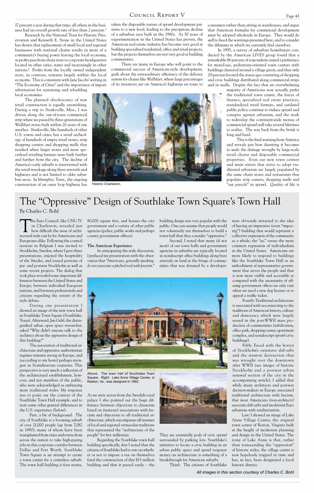
Page 43Council Report V
The Euro Council, like CNU IV in Charleston, revealed just how difficult the issue of archi-
tectural style can be for Americans and Europeans alike. Following the council sessions in Belgium I was invited to Stockholm, Sweden, where I gave three presentations, enjoyed the hospitality of the Swedes, and toured portions of pre- and postwar Stockholm as well as some recent projects. The dialog that took place revealed some important dif-ferences between the United States and Europe, between individual European nations, and between professionals and citizens regarding the extent of the style debate.
During one presentation I showed an image of the new town hall in Southlake Town Square (Southlake, Texas). Afterward, Jan Gehl, the distin-guished urban open space researcher, asked “Why didn’t anyone talk to the architect about the oppressive design of this building?”
The association of traditional ar-chitecture and oppressive, authoritarian regimes remains strong in Europe, and (according to my hosts) perhaps stron-gest in Scandinavian countries. This perspective is very much a reflection of the architectural establishment, how-ever, and not members of the public, who were acknowledged as embracing more traditional styles. My response was to point out the context of the Southlake Town Hall example, and to note some other general differences in the U.S. experience (below).
First, a bit of background: The city of Southlake is a booming suburb of over 21,000 people (up from 7,082 in 1990), many of whom have been transplanted from cities and towns from across the nation to take high-paying jobs in this corporate corridor between Dallas and Fort Worth. Southlake Town Square is an attempt to create a town center for a centerless suburb. The town hall building is four stories,
80,000 square feet, and houses the city government and a variety of other public agencies (police, public works and perhaps county government offices).
The American ExperienceIn anticipating the style discussion,
I prefaced my presentation with the obser-vation that “Americans, generally speaking, do not associate a pitched roof with fascism.”
As we were across from the Swedish royal palace I also pointed out the huge dif-ference between objections to classicism based on (tenuous) associations with fas-cism and objections to all traditional ar-chitecture, which encompasses all manner of local and regional vernacular traditions that represented the “architecture of the people” for five millennia.
Regarding the Southlake town hall building specifically, first I noted that the citizens of Southlake had to vote on wheth-er or not to impose a tax on themselves fund the construction of this $15 million building and that it passed easily – the
The “Oppressive” Design of Southlake Town Square’s Town Hall
17 percent a year during that time; all others in the busi-ness had an overall growth rate of less than 2 percent.3
Research by the National Trust for Historic Pres-ervation and Kenneth E. Stone in the United States has shown that replacement of small local and regional businesses with national chains results in more of a community’s buying power leaving the local economy, as profits pass from chain store to corporate headquarters located in other cities, states and increasingly in other nations.4 Profits from the locally owned independent store, in contrast, remains largely within the local economy. This is consistent with Jane Jacobs’ writing in “The Economy of Cities” and the importance of import substitution for sustaining and rebuilding local economies.
The planned obsolescence of new retail construction is equally astonishing. During a trip to Starksville, Miss., I was driven along the out-of-town commercial strip where we passed by three generations of WalMart stores built within 20 years of one another. Starksville, like hundreds of other U.S. towns and cities, has a retail archeol-ogy of hundreds of empty retail stores, strip shopping centers and shopping malls that resulted when larger stores and more spe-cialized retailing formats were built further and further from the city. The decline of America’s early suburbs is intertwined with the retail wreckage along these arterials and highways and is not limited to older subur-ban areas. In Memphis, Tenn., the ongoing construction of an outer loop highway has
taken the disposable nature of sprawl development pat-terns to a new level, leading to the precipitous decline of a suburban area built in the 1980s. As 50 years of experimentation in the United States has proven, the American real estate industry has become very good at building specialized residential, office and retail projects, but the projects themselves are not very good at building communities.
There are many in Europe who will point to the commercial success of American-style development, gush about the extraordinary efficiency of the delivery system for chains like WalMart, where large percentages of its inventory are on America’s highways en route to
consumers rather than sitting in warehouses, and argue that American formulas for commercial development must be adopted wholesale in Europe. They would do well to heed the warnings presented here, and to consider the dilemma in which we currently find ourselves.
In 1995, a survey of suburban homebuyers con-ducted by the American LIVES group found that a remarkable 86 percent of respondents stated a preference for mixed-use, pedestrian-oriented town centers with buildings clustered around a village green, and that only 29 percent favored the status quo consisting of shopping and civic buildings distributed along commercial strips and in malls. Despite the fact that an overwhelming
majority of Americans now actually prefer the traditional town center, the forces of finance, specialized real estate practices, standardized retail formats, and outdated public policy continue to induce sprawl and conspire against urbanism, and the work to redevelop the continent-wide morass of commercial sprawl will take several lifetimes to realize. The way back from the brink is long and hard.
This is the final warning from America and reveals just how daunting it becomes to undo the damage wrought by large-scale retail chains and disposable commercial properties. Even our new town centers and main streets that strive to adopt tra-ditional urbanism are largely populated by the same chain stores and restaurants that populate strip centers, shopping malls and “out parcels” in sprawl. Quality of life is
building design was very popular with the public. One can assume that people would not voluntarily tax themselves to build a town hall that they consider “oppressive.”
Second, I noted that many (if not most) of our town halls and government agencies in suburbia are typically located in nondescript office buildings along busy arterials on land at the fringe of commu-nities that was donated by a developer.
They are essentially pods of civic sprawl surrounded by parking lots. Southlake’s initiative to locate a civic building in an urban public space and spend taxpayer money on architecture is something of a breakthrough for American suburbs.
Third: The citizens of Southlake
were obviously attracted to the idea of having an impressive (even “impos-ing”) building that would represent a collective expression of the community as a whole; the “us,” versus the more common expression of individualism in the United States. Americans are more likely to respond to buildings like the Southlake Town Hall as an embodiment of representative govern-ment that serves the people and that is now more visible and accessible as compared with the anonymity of off-ramp government offices we only visit when we need a new dog license or to appeal a traffic ticket.
Fourth: Traditional architecture is associated with reconnecting to the traditions of American history, culture and democracy which were largely erased in the post-WWII mass pro-duction of communities (subdivision, office park, shopping center, apartment complex, and nondescript sprawl civic buildings).
Fifth: Faced with the horror of Stockholm’s extensive slab-urbs and the wanton destruction that was wrought over the downtown after WWII (see images of historic Stockholm and a postwar urban renewal section of the city in the accompanying article), I added that while many architects and postwar decision-makers in Europe associated traditional architecture with fascism, that most Americans (non-architects) associate slab-urbs and modernist Euro urbanism with totalitarianism.
Last: I showed an image of Lake Anne Village Center, the original town center of Reston, Virginia built at the height of modernist planning and design in the United States. The irony of Lake Anne is that, rather than transcending the “oppression” of historic styles, the village center is now hopelessly trapped in time and has, in fact, been designated a local historic district.
Historic Charleston.
Above: The town hall of Southlake Town Square. Right: Lake Anne Village Center, in Reston, Va., was designed in 1962.
All images in this section courtesy of Charles C. Bohl
By Charles C. Bohl

Page 44
not equivalent to cost of living, and the value of savings wrought from purchases of jumbo rolls of toilet paper at WalMart is not a perfect substitute for the social use value or the employment and community reinvestment value of corner stores and family-owned and run businesses. Cash-ing in the European way of life for cheaper underwear and 57 varieties of toothpaste instead of 12 is a myopic exchange and cuts to the heart of European apprehen-sions over the Americanization of their economies and cultures.
The Second Coming of the European Market Place
I do a presentation titled “The Second Coming of the American Town Center.” For the EuroCouncil I reinter-preted this as “The Second Coming of the Market Place,” for this is what European urbanists must bring about with respect to changes in retail practices that are already upon them. It is not a question of turning back the clock; the genie is out of the bottle and Europeans will continue to demand opportunities to purchase lower cost goods and services. It is also likely that development on the outskirts of European cities will continue as the need for housing increases development pressures. This article, and most that discuss town centers, puts an emphasis on retail, but the way back from commercial sprawl involves confronting each piece of single-use sprawl – residential, office, retail, hotel, civic, light industry – and re-assembling portions of this in the form of traditional neighborhoods, town centers, high streets and market places.
To protect European town centers, market places and high streets at all costs, the United States offers pragmatic, hard-earned knowledge on how to begin rec-onciling the demands of modern retailing and large-scale commercial, office and residential development with the practice of urban place making. My book “Place Making” (Urban Land Institute, 2002) chronicles the first attempts to reconcile these opposing forces in the United
States; I included several examples of this in my presentation at the EuroCouncil.
U.S. developers and designers have advanced rapidly to develop urban design and real estate strategies that adapt large-scale retail, office and residential uses to more urban formats. This has involved countless challenges to conventional practices and beliefs concerning parking, highway access and visibility, market ac-ceptance of urban residential and office types, reconfiguration of big boxes to pro-vide a street-orientation, and entrenched finance, development and management practices in a pure market-based system. Turning these conventional models around has been an impressive accom-plishment and one that can inform the European struggles to adapt the now pervasive moves to introduce American-style commercial development.
Americans, on the other hand, still have much to learn from their European counterparts with respect to architecture, especially in cases involving the urban core. I highlighted the weak architecture of many U.S. town center projects during my EuroCouncil presentation. In the United States, the struggle to move from the low level of design skill and invest-ment required for a conventional strip mall facade to those capable of creating a respectable urban retail architecture has been daunting and very much a matter of dollars over design. Without any assur-ance that a pedestrian-oriented, mixed-use format would succeed, developers were loathe to lavish money on architecture, and still decry what they consider exces-sive premiums paid for the architecture and design of new town centers. Within the short-term investment time frame of most U.S. developers, these are costs that can only be justified through greater public subsidy of town centers (something much more unusual in the United States than in Europe) or evidence of higher profits to developers (something yet to be established).
There is reason for hope, however, as a quick chronological survey of United States town center projects built since the mid-1980s reveals some dramatic and very obvious improvements in their architecture as each new project has raised the standard for those that follow.
As the general quality of architecture in U.S. projects improves, the lingering issue for Europeans will concern architectural style. (See sidebar, “The ‘Oppressive’ Design of Southlake Town Square’s Town Hall”).
In the United States we are just be-ginning to rediscover the possibilities for creating complex, civic-oriented, human scale market places. Some of our greatest inspiration comes from the historic mar-ket places and high streets of Europe. The new U.S. town centers pale in comparison to these great historic urban settings, but their stature grows when placed alongside Europe’s slab-urbs, town centers of new towns, and contemporary Eurosprawl.
In time the new U.S. town centers may evolve into richer, more complex urban places, but here, at the time of their birth, they are urban fragments (perhaps seeds) in a sea of sprawl. But each one also represents a real world learning experience in how to reconcile the age of the automobile, large scale retailing and other specialized development, and the realities of 21st century real estate finance and development practices. To that end they are experiments extremely worthy of further study on both sides of the Atlantic.
Endnotes1The term “Shop and Awe” is a reference to the “Shock and Awe” tagline given to the US assault on Iraq. The assault occurred in March 2003, one week before the EuroCouncil in Belgium took place.
2 “Italians Bid Arrivederci To Mom-And-Pop Gro-cers,” Los Angeles Times, February 16, 2003.
3 “Retailers Making Big Plans Despite Warning Signs,” The Record (Bergen County, NJ), May 16, 1999.
4 Stone, Kenneth E., “Impact of Wal-Mart Stores and other Mass Merchandisers in Iowa, 1983-1993,” Economic Development Review, spring, 1995.
Middle and bottom, right: The standard American shopping experience. Are Europeans prepared to trade cheap goods in exchange for replacing the Euro-pean way of life with the American way of life?
Left: A series of images illustrates the increasing sophistication of town designs over a period of years. From top to bottom: Miami Lakes, Fla. (1960); Mashpee Commons, Mass. (1986) and the recent retrofit of its clock tower (1999); Mizner Park, Fla. (1989); City Place, Fla. (1998); Santana Row, Calif. (2000).
Aerial view of typical United States sprawl reveals the rigid segregation of land uses.
American Perspectives

Page 45Council Report V
The cycle of modernist ideology has left Europe, invaded America, and is about to return to its spawning
grounds in a nefarious form – vehicle dominance. The idea of the building as a machine stripped of ornament, functional and sterile, was extrapolated to urban pattern at the hands of CIAM. One of its members, Ludwig Hilbersheimer, developed a simple, and deadly, “func-tional” system of street patterns that were adopted by American bureaucracies as the arterial, collector and local. This system has proven deadly to the pedestrian and to human scale urbanism. As shown in Figure 1 the regularized pattern concen-trated traffic from cul-de-sacs to larger ar-teries in a lifeless hierarchy that glorified function over form. The brutal efficiency of this system was remarkably successful in conveying tons of metal carriages in a fast and direct manner from one concen-trated monocultural pod to another. The cheapness of this mode in moving goods and people to and from their activity nodes also bore a highly profitable auto industry, and is sustained by that industry. One of the progeny of this effort was the American Main Street as the replacement of traditional European shopping districts and neighborhood centers. Main Street America was quite functional for a period of time until the Euclidean zoning pods began to metastasize as the shopping mall. The cancer needed to be supplied with ar-teries extending through, and destroying much of classical pre-war town centers.
As substantiated by recent research, Americans are getting fat and listless as their bloated bodies are transported ef-fortlessly within two tons of Detroit steel through one rat maze to another. Our sub-urban places have spread in a kind of melanoma across the face of the coun-tryside, guaranteeing that we are now constantly in the company of strangers while we shop and recreate. In an attempt to return our lives to some form of sanity we look again to pre-World War II models like the Garden City or City Beautiful Movement for guidance in urban design. We have gleaned the best of those tech-niques, but we also see vehicle dominance creeping up on Europe. Many European cities are now experiencing redevelop-ment in the form of glass box buildings and arterial streets. The existing formal or medieval fabric is being replaced with modernist functionality. This trend will
not abate unless action is taken to pre-serve the humanity of our older places. American have actively combated this condition for a couple of decades; solu-tions to several problems have been found in that experience.
The idea that walkable, mixed-use urbanism performs differently than conventional systems is
beginning to change traffic engineering design standards. To have a walkable environment we must have a multi-modal environment. That is to say, the vehicle must coexist with pedestrians, bicyclists, the handicapped and transit. Narrow streets must be allowed. Current design regulations require that even residential streets must accommodate high design speeds. We have discovered that the frequency of injury accident rates in-creases exponentially with just a few feet of additional street width (Figure 2). In addition, the severity of injuries also in-creases exponentially with speed (Figure 3). When a pedestrian is hit at 36 miles per hour (60 kph), they die within 30 days of the accident. At 28 mph (47 kph) they can experience permanent neurological damage, severed spinal cords and the like. A 20 mph (33 kph) accident will cause minor abrasions and perhaps a crushed digit. We therefore design streets to oper-ate generally at 20 mph. This means that streets must be relatively narrow.
Fire fighters balk at such a condi-tion. They have legitimate concerns about accessing structure fires in confined areas. The solution to this is to provide a connected network of streets and alleys, specific areas for the fire apparatus to operate and well positioned fire hydrants. A connected network allows for a multi-directional attack strategy. There will be a number of ways to approach the fire.
The Uniform Fire Code states that there must be 20 feet (6.1 meters) of clear roadway not including parking. Parking is also stated in conventional sources to be 8 feet (2.4 meters) wide for parallel parking. This yields a required minimum of 36 feet (11 meters) for any street. This is an unac-ceptable width for traditional urbanism. A way to reduce the width of a street is to understand that a pumper truck will have at least 150 feet (46 meters) of hose that can be extended to the fire. This means that fire trucks can operate about 260 feet (79 meters) apart as demonstrated in Fig-ure 4. So-called “red zones” that prohibit parking are established in areas that will experience high parking densities. Alleys are also a very efficient way of attacking a fire because they allow two other means
A Warning to Europe: Traffic Specialists Will Destroy Your CitiesBy Peter Swift, P.E.
Figure 1: Ludwig Hilberseimer envisioned an efficient, lower-density city with a clear circulation hierarchy according to function and sharply separated land uses. All homes were to be located on cul-de-sacs. Schools were placed in green space between residential districts.
of approaching the incident. Another way to deal with this situ-
ation is simply to buy smaller vehicles. This is done commonly throughout the world. Many fire departments in the United States pay higher rates to those who operate larger vehicles. Perhaps it would be better to pay higher wages to those that use smaller apparatus.
Another element in traditional design is to look at thoroughfares with regard to their context. We
know that, historically, context changes with land use and building type. The thoroughfare types must respond to con-text. The current classification of only three types (arterial, collector and local) is only applicable in a vehicle dominant environment. Consequently we propose to have at least eight types that change within the four urban Transect context zones (T3-T6). This results in having 32
thoroughfare types. This is a more ap-propriately complex typology that reflects a more complex urbanism. In America there has been a lot of discussion in the literature of Context Sensitive Design, Context Sensitive Solutions and so on. Many of these techniques are compiled in Report 480 from the NCHRP “A Guide to Best Practices for Achieving Context Sensitive Solutions.” Their definition of CSS boils down to vehicle management and compiling lists of neighborhood com-plaints. This is not context. It is a further affirmation of the evolving philosophy in the United States that conventional design techniques can address emerging sophisticated problems. It does not look symptomatically at the underlying dys-function. Beware, those of you in Europe, of this inadequate strategy.
Figure 4: Fire truck access diagram showing operating reach, restricted parking and alleyway approaches.
Figure 3. Chart by Peter Swift.
Figure 2. Graph by Peter Swift.
See SWIFT, page 48

Page 46
The design of our homes, towns and cities affects almost every aspect of our lives.
If we want to build places for people, then it follows that we must put people’s needs, aspirations and feelings at the very heart of the design process. This requires us to think carefully about how we orientate buildings and roads to make it easier for people to work, shop, play, to find their way around, or simply to meet and chat without having to travel miles to do so. It means considering the effect that the design of a build-ing has not just on the person who lives there, but the person in the street who sees it as more than just a building, but part of what it is that makes that town or city uniquely beautiful, identifiable, functional and therefore worth belonging to. If we start with this in mind then we will design towns and cities that people want to live in and look after, and which cannot help but thrive and ultimately stand the test of time.
What is the Prince’s Foundation?The Prince’s Foundation for the Built Envi-
ronment is an educational charity established by The Prince of Wales to teach and demonstrate in practice those principles of traditional urban design and architecture that put people and the communi-ties of which they are part at the center of the design process.
Why was it formed?In 1989 The Prince of Wales published his book
“A Vision of Britain” to highlight the plight of many of our towns and cities and the need for their sensitive regeneration. After two world wars the dream of re-placing slums and bomb-damaged districts with “bold, scientific and rational” urban design and architecture has, in many cases, failed both the individual and the community and frequently led to vandalism and so-cial isolation. This caused The Prince of Wales to call for a greater understanding of those principles that underpin the design of our long-established towns and cities – those principles that still have relevance today, that are proven to foster a better quality of life, and that engender a sense of civic pride.
The prince’s ideas, embodied in his own develop-ment, Poundbury (the urban extension to Dorchester), stimulated an international debate, challenging archi-tects, developers and governments to take practical action to change the way we build our towns and cities. A number of initiatives were subsequently launched, and a decade later many were brought together under the banner of The Prince’s Foundation for the Built Environment.
What does The Prince’s Foundation do?
The Foundation offers three interconnected services.
Education The Foundation offers a flexible, highly-intensive
short course program that embraces a number of key areas of traditional urban design and architecture. Based at its premises in Shoreditch, East London, and geared principally, but not exclusively, towards the industry professional, the courses are taught within the context of existing “live” projects. This ensures that the program is consistently cutting-edge and continues to evolve to meet the differing needs of its participants.
Consultancy
The Foundation has a core team of urban and landscape designers, architects, heritage building specialists, project managers and facilitators. This team disseminates the principles of traditional town-making and architecture at a practical level by providing pro-
fessional support for both public and private clients on a variety of projects, ranging from small-scale heritage building regeneration to large-scale urban extensions.
Research The Foundation carries out commissioned re-
search in partnership with practitioners and academ-ics in order to keep the organization at the forefront of learning in the built environment, and to keep the traditions of urban design and architecture alive and relevant to 21st century building practice.
What underpins the Foundation’s work?From the fifth century bc to the 1940s, the
practice of architecture and urban design in Western Europe was based on an evolving body of knowledge handed down from one generation to the next. This knowledge was founded on a set of carefully refined principles that, though articulated in different ways at different times, have remained fundamentally con-stant. No matter how each generation of architects and designers have interpreted these principles, whether it be the Georgian crescents of Bath or the Art Nouveau architecture of Glasgow, these principles continued to be observed because they recognize the needs of human beings and their rightful place at the center of the design. As our most successful cities so clearly demonstrate – through the proportions of the build-ings, the way buildings relate to others around them, their density, mix of use and mix of tenure – they have a unity and a “humanity” about them. These cities have stood the test of time functionally, economically and aesthetically. It is only in the last 80 years that these principles have been largely abandoned in favor of experimentation. The Foundation exists to provide a center of excellence where an understanding of the traditions of urban design and architecture can be fostered. Traditions are taught, not to replicate the past, but in order that lessons learned from the way people have historically chosen to build and integrate with their environment can usefully inform and benefit the building of the towns and cities of today.
What are these design principles?Many of these values, while relatively simple
to express, can be complex to realize. The following values are developed from those set out by The Prince of Wales in “A Vision of Britain.” These principles help The Prince’s Foundation teach a common language with the aim of enabling different professionals to work
together more closely and engage nonprofessionals in the design process. Place – Design that respects the complex character of a place and takes into consideration its history, geology, transportation links and natural landscape.
Encourages: Individual character and a sense of belonging to a place
Discourages: Soulless, anonymous develop-ment.
Permeability – Urban design in which blocks of buildings are fully permeated by an interconnected street network.
Encourages: Ease of access and a greater spread of traffic movement
Discourages: Congestion and an oppressive sense of impenetrability.
Hierarchy – A clear and legible ordering system that recognizes a hierarchy between types of buildings or roads and their individual parts in relation to the whole.
Encourages: An understanding of the relative significance of parts of a building or town and easy navigation within each.
Discourages: Confusion and overreliance on signage.
Longevity – Design that creates streets and buildings that will cope with a variety of uses during their lifetime.
Encourages: Design solutions based on ex-amples that have adapted well to change.
Discourages: Complex buildings that are very specific to current need.
Value – Design that creates a valuable asset in eco-nomic, social and environmental terms.
Encourages: Long-term investment in buildings, towns and cities.
Discourages: Buildings and places that are likely to drain the resources of future generations to no advantage.
Scale – Towns and buildings, which, whatever their size, relate to human proportions.
Encourages: A relationship between people and their built environment.
Discourages: A feeling of being overwhelmed and alienated.
Harmony – Design that sounds its own “note” and yet blends with the local and natural environment.
Encourages: Buildings and towns whose various parts work together and respect the value of the whole.
Discourages: A confused and oppressive built environment.
Enclosure – Design that establishes clear distinction between town and country, public and private space, thus encouraging appropriate activities within each.
Encourages: Safe environments and the full and appropriate use of available space.
Discourages: Wasteland and degraded no-go areas.
Materials – Design using materials that, wherever possible, are indigenous, have a natural harmony with the landscape, and are selected with care to ensure they improve with age and weathering.
Encourages: Buildings that have a natural reso-nance with their environment and that can be easily repaired.
Discourages: Long distance transport of materi-als. Buildings with short life spans.
Decoration – Design whose decoration not only enhances the quality and beauty of a building but helps engender emotional value and personal and cultural relevance.
Encourages: Visual identity and interest, as well as fine craftsmanship.
Discourages: Functional anonymity.
Craftsmanship – The care and attention with which a building is made rewards both the maker and the user and makes it likely to last and be valued by future generations.
The Prince’s Foundation for the Built EnvironmentBy The Prince’s Foundation
NOTE: The following is a preview of a final draft of the document prepared to help the public-at-large better understand the work of the Founda-tion. As an essential part of the our mission is to connect local communities to their built environ-ment, we must be able to explain in lay terms what we actually do. Also, by listing the principles we have developed and simplified, we hope to build a common vocabulary between people that will en-able us all to talk with a greater degree of accuracy about matters concerning the built environment.
European Resources
The headquarters of the Prince’s Foundation is in the Shoreditch neighborhood of London’s East End. This internal view shows a roof designed and constructed by students who attended the former Foundation Course. Photo courtesy of The Prince’s Foundation.

Page 47Council Report V
The Foundation for Urban Renewal was estab- lished on December 21, 1998, and has the following objects clause in its Articles of As-
sociation: “The object of The Foundation for Urban Renewal is to promote traditional architecture and the development of urban areas. This is done both in Norway and abroad through investigation, projects and the dissemination of information, through coop-eration with other organizations with similar objects, through exerting influence on public authorities and developers, and through other activities which are in accordance with the object of the Foundation.”
Basic Concept of the FoundationIt is self-evident that towns, smaller communi-
ties and buildings should be designed to enrich the life of the individual and to encourage constructive social activities among those who live there. But 20th century building development has to a large extent created chaotic towns, depressing architec-ture and communities destroyed by traffic systems. Solving these problems will require both creativity and renewed insight into the traditional methods of approach that have proved successful in the past.
Through its work, The Foundation for Urban Renewal wishes to contribute to restoring continu-ity in the development of building style and urban design. There is a need for a corrective to the desire of functionalism and modernism to break with ex-perience and tradition. This is because modernism has created new problems rather than solving the challenges society faces with regard to architecture and town planning, and also because it is clear that traditional and local building styles appeal to a need that is deeply rooted in a great number of people.
Restoring contact with our architectural heri-tage can, for example, mean moving towards historical models through the use of established design systems when building new developments in older parts of towns. Traditional architecture can provide a wealth of ideas and elements that can be used in diversified contemporary architecture.
But the point is not to reject all modernistic architecture in the same way that many modernists reject all traditional architecture. The objective must be to foster awareness of architecture and urban design so that the best solution is chosen with regard to the case in question and the urban environment under consideration.
The goal of urban development must be to fulfill a wide range of the needs of the residents, including social and aesthetic qualities. To ensure that emphasis
is given to these needs, and to create a counterbalance to the desire of the developers, politicians and architects for self-realization, residents should increase their com-mitment and influence on decisions that will affect local environments.
Organization The Foundation for Urban Renewal is organized
as a nonprofit association directed by a board, with a manager who is responsible for getting the activities under way. The board is assisted by a committee that has approximately 15 members. This committee gives feedback on the Foundation’s projects and acts as an ideas bank for new activities.
The work of the Foundation depends on support from private sponsors and public funds, e.g. cultural grants in connection with exhibitions and arrangements.
Tasks Activities started by the Foundation include:Encouraging debates on architecture and town
planning – We have arranged several discussion meet-ings in Oslo and Trondheim and have been active in public debates through newspaper articles and radio/TV programs.
Exhibitions – The Foundation has organized several large exhibitions in Oslo and one in Trondheim. These have been in connection with the international touring exhibition “Urban Renaissance” under the auspices of the organization A Vision of Europe, and a presentation of Norwegian projects based on traditional architecture (e.g. Tullinløkka and Gamlebyen in Oslo, and Bakklandet and Svartlamon in Trondheim). The Foundation participated a touring exhibition of tradi-tional European town architecture from the 20th century called “The Other Modern.” This opened in Bologna in 2000, and included Norway and Germany in its tour.
Web site – Our web site (www.byen.org) is at pres-ent being developed into a comprehensive presentation of our ideas, both the theoretical aspects and examples from Norway and abroad.
Lectures, courses and study trips – With architects and other interested parties as the target group, the Foun-dation has arranged guest lectures (including a lecture by Léon Krier), a study trip to England, and participation in congresses arranged by related organizations. We aim to run courses on the practical aspects of traditional architecture in the future.
Alternative projects – The Foundation took part in the public presentation of the alternative project for Tullinløkka Museum Project; “Edvard Munch Hall.” We have also presented a project for the placement of the
The Foundation for Urban Renewal By Audun Engh
Encourages: Longevity. The inspiration of gen-erations of potential practitioners of building crafts as an art form.
Discourages: Quick-fix solutions and low-grade buildings that rely on assembly only.
Public Space – A recognition that the design of public areas including “street furniture,” signage and lighting, is as important as the design of private spaces and should be designed as part of an harmonious whole.
Encourages: Harmonious and legible public areas.
Discourages: Visual intrusion and clutter.
Community The carefully facilitated, early involvement of the
local community in order to create places that have a civilizing influence, which meet people’s needs, desires and aspirations, and engender civic pride.
Encourages: A proactive, holistic approach to planning.
Discourages: A reactive, piecemeal approach to planning and a compromised result.
What makes the Prince’s Foundation unique?The Prince’s Foundation, together with its visiting
faculty and associated network of practitioners, offers the only educational and advisory service in the fields of traditional urbanism and architecture in the UK. Its independent approach encourages design solutions based
collections in the Norwegian Historical Museum at Sørenga in Oslo. During our exhibition in Trondheim in spring 1998, we showed our proposal for new dwell-ings in appropriate style for the traditional Bakklandet neighbourhood in Trondheim. The proposal roused great interest and contributed to the fact that Trond-heim municipality has so far shelved its plans for a modernistic new development on the plots in question.
Cooperation with local residents’ groups – Our general experience is that active resident groups almost without exception support suggestions based on preserving the distinctive features of the area and creating new developments in a style adapted to that of existing buildings. In connection with our proposal for the museum at Sørenga, we have been in contact with local organizations in Gamlebyen, part of Oslo town. In Trondheim we collaborated with the Svartlamon residents group to present their alternative develop-ment plan for the threatened district. We helped to finance the production of a video that was sent to all local politicians to put forward the residents’ view on the demolition plans. In the battle over the new development at Bakklandet, we have been in contact with the residents association and have provided an exhibition and other input for their arrangements.
International collaboration – The Foundation collaborates with groups in other countries who have similar objectives. These include:
INTBAU, International Network for Traditional Building, Architecture and Urbanism, www.intbau.org
The Prince‘s Foundation, www.princes-foundation.org
A Vision of Europe, www.avoe.org
CNU, Congress for the New Urbanism, www.cnu.org
CEU, Council for European Urbanism, www.eurocouncil.net
Contact information:
Foundation for Urban Renewal (Stiftelsen Byens Fornyelse) St. Olavs gate 9, 0165 Oslo, Norway
Tel +47.22363710, +57.92622626Fax +47.22364993E-mail: [email protected] site: www.byen.org
See PRINCE’S FOUNDATION, next pageExterior of the Prince’s Foundation headquarters, in the Shoreditch neighborhood of London’s East End. Photo courtesy of The Prince’s Foundation.
on common sense for the common good.
What has it achieved?
Over the last five years The Foundation has been involved in over 60 urban design, architectural, regen-eration, healthcare and heritage projects throughout Britain, and has contributed not only to the enhance-ment of their design and build quality, but to greater community involvement in the planning process.
The Prince’s Foundation’s educational programs draw on its projects’ successes to offer a unique way of learning. Over 400 alumni of the Foundation’s various educational courses now operate throughout the world, working to improve the quality of the built environment and disseminating the principles for which it stands.
The Foundation has pioneered a number of design processes, including the “Enquiry by Design” process, which has been universally adopted as a cutting-edge tool for planning new places. This innovative and col-laborative approach to creating communities promotes a higher quality of design and a smoother, quicker route through the planning process.
For a number of years, the Foundation has been at the forefront of developing urban policy through its publi-
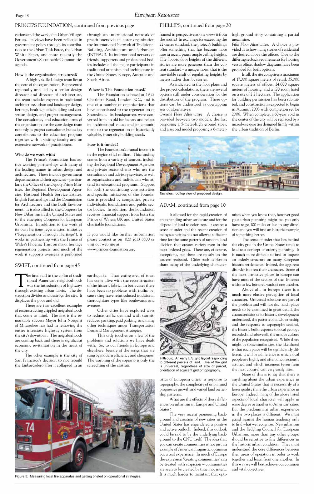
Page 48
It allowed for the rapid creation of an expanding urban structure and for the disposal of land to colonizers. It creates a sense of order and the recent creation of many such cities has not allowed sufficient time for the same pattern of random land division that creates variety even in the most ordered grids. There are, of course, exceptions, but these are mostly on the eastern seaboard. Cities such as Boston share many of the underlying character-
istics of European cities: a response to topography, the complexity of unplanned progressive growth and varied land owner-ship patterns.
What are the effects of these differ-ences on urbanism in Europe and United States?
The very recent pioneering back-ground and creation of new cities in the United States has engendered a positive and active outlook. Indeed, this outlook could be said to be the underlying back-ground to the CNU itself. The idea that you can create communities is not just an example of American linguistic optimism but a real experience. In much of Europe the expression “creating communities” can be treated with suspicion – communities are seen to be created by time, not intent. It is much harder to maintain that opti-
Pittsburg. An early U.S. grid layout responding to different parcels of land. Use of the grid is universal, regardless of size of parcel, orientation of adjacent grid or topography.
mism when you know that, however good your urban planning might be, you only have to go 100 miles or less in any direc-tion and you will find an historic example of something better.
The sense of order that lies behind the city grid in the United States tends to lead to a concept of orderly planning. It is much more difficult to find or impose an orderly structure on many European historic settlements. Indeed, the apparent disorder is often their character. Some of the most attractive places in Europe can have most of the sectors of the Transect within a few hundred yards of one another.
Above all, in Europe there is a much more elusive perception of local character. Universal solutions are part of the problem and will not do. Each place needs to be examined in great detail, the characteristics of its historic development understood, the pattern of land ownership and the response to topography studied, the historic built response to local geology recorded and, above all, the unique culture of the population recognised. While there might be some similarities, the likelihood is that each place will be significantly dif-ferent. It will be a difference to which local people are highly and often unconsciously attuned and which incomers (even from the next county) can very easily miss.
None of this is to say that there is anything about the urban experience in the United States that is necessarily of a lesser quality than the urban experience in Europe. Indeed, many of the above listed aspects of local character will apply in some degree or another to American cities. But the predominant urban experience in the two places is different. We must guard against the human tendency only to find what we recognise. New urbanism and the fledgling Council for European Urbanism, more than any other groups, should be sensitive to fine differences in the historic urban condition. They must understand the core differences between their areas of operation in order to work together and learn from one another. In this way we will best achieve our common and vital objectives.
Figure 5: Measuring local fire apparatus and getting briefed on operational strategies.
The final nail in the coffin of tradi- tional American neighborhoods was the introduction of highways
through existing urban fabric. The de-struction divides and destroys the city. It displaces the poor and old.
There are two excellent examples of reconstructing crippled neighborhoods that come to mind. The first is the re-markable success Mayor John Norquist of Milwaukee has had in removing the entire interstate highway system from the city’s downtown. The neighborhoods are coming back and there is significant economic revitalization in the heart of the city.
The other example is the city of San Francisco’s decision to not rebuild the Embarcadero after it collapsed in an
earthquake. That entire area of town has come alive with the reconstruction of the historic fabric. In both cases there have been no problems with traffic be-cause they have reintroduced traditional thoroughfare types like boulevards and avenues.
Other cities have explored ways to reduce traffic demand with transit, reduced parking, paid parking, and many other techniques under Transportation Demand Management strategies.
This only touches on a few of the problems and solutions we have dealt with. So, to our friends in Europe and elsewhere, beware of the songs that are sung by modern efficiency and cheapness. The warbling of the soprano is only the screeching of the castrati.
framed in perspective as one views it from the south.) In exchange for exceeding the 22-meter standard, the project’s buildings offer something that has become more rare in recent years: ample ceiling heights. The floor-to-floor heights of the different stories are more generous than the cur-rent standard – a meager norm that is the inevitable result of regulating heights by meters rather than by stories.
As indicated in the floor plans and the project calculations, there are several options still under consideration for the distribution of the program. These op-tions can be understood as overlapping sets of alternatives:Ground Floor Alternative: A choice is provided between two models, the first proposing a 5-meter-high ground story, and a second model proposing a 6-meter-
high ground story containing a partial mezzanine. Fifth Floor Alternative: A choice is pro-vided as to how many stories of residential are desired above the offices. Due to the differing setback requirements for housing versus office, shadow diagrams have been provided for both options.
In all, the site comprises a maximum of 17,000 square meters of retail, 35,000 square meters of offices, 24,000 square meters of housing, and a 170 room hotel on a site of 2.2 hectares. The application for building permission has been submit-ted, and construction is expected to begin in Autumn 2003 with completion set for 2006. When complete, a 60-year void in the center of the city will be replaced by a mixed-use quartier designed firmly within the urban tradition of Berlin.
PHILLIPS, continued from page 20
through an international network of practitioners via its sister organization the International Network of Traditional Building, Architecture and Urbanism (INTBAU). Its international network of friends, supporters and professional bod-ies includes all the major participants in traditional urbanism and architecture in the United States, Europe, Australia and South Africa.
Where is The Foundation based?The Foundation is based at 19-22
Charlotte Road, London EC2, and is one of a number of organizations that have contributed to the regeneration of Shoreditch. Its headquarters were con-verted from an old fur factory and reflect its architectural values and its commit-ment to the regeneration of historically valuable, inner city building stock.
How is it funded?The Foundation’s annual income is
in the region of £3 million. This funding comes from a variety of sources, includ-ing the Regional Development Agencies and private sector clients who use the consultancy and advisory services, as well as organizations and individuals who at-tend its educational programs. Support for both the continuing core activities and specific initiatives of the Founda-tion is provided by companies, private individuals, foundations and public sec-tor bodies. In addition, the Foundation receives financial support from both the Prince of Wales’s UK and United States charitable foundations.
If you would like further information please contact us on 020 7613 8500 or visit our web site at:www.princes-foundation .org
PRINCE’S FOUNDATION, continued from previous page
cations and the work of its Urban Villages Forum. Its views have been reflected in government policy through its contribu-tion to the Urban Task Force, the Urban White Paper, and more recently the Government’s Sustainable Communities agenda.
How is the organization structured? A highly skilled design team lies at
the core of the organization. Represented regionally and led by a senior design director and director of architecture, the team includes experts in traditional architecture, urban and landscape design, heritage, health, public building and con-sensus design, and project management. The consultancy and education arms of the organization use the core design team not only as project consultants but as key contributors to the education program together with a visiting faculty and an extensive network of practitioners.
Who do we work with?The Prince’s Foundation has ac-
tive working partnerships with many of the leading names in urban design and architecture. These include government departments and their agencies – particu-larly the Office of the Deputy Prime Min-ister, the Regional Development Agen-cies, National Health Service Estates, English Partnerships and the Commission for Architecture and the Built Environ-ment. It is also allied to the Congress for New Urbanism in the United States and to the emerging Congress for European Urbanism. In addition to the work of its own heritage regeneration initiative (“Regeneration Through Heritage”), it works in partnership with the Prince of Wales’s Phoenix Trust on major heritage regeneration projects, and much of the work it supports overseas is performed
ADAM, continued from page 10
SWIFT, continued from page 45
Tacheles, rooftop view of proposed design.
European Resources

Page 49Council Report V
The acronym INTBAU – for International Net work for Traditional Building, Architecture & Urbanism – was a working name we used during
the development period that stuck before any of us could think of something a bit more zippy. It sounds vaguely Teutonic, though my German friends say it sounds like the name of a scaffolding company. My mother, something of a Francophile, suggested we add the word “environment” to the mix to make INTBEAU, but this was rejected by the steering committee and the acronym stayed. We’d welcome suggestions for improvement but recognize that we have nearly three years of world-wide publicity under this name, and that would be a difficult change to make with our limited resources.
The research project that led to the establishment of the organization was the initiative of Ben Bolgar, Robert Adam and several others after the Vision of Europe conference and exhibition entitled “The Other Modern” held in Bologna in March 2000. I was appointed in September 2000 and funded by Norwegian property investor Petter Olsen.
INTBAU is directed by a 14-person international management committee including a Brit, a Scot, a German, a Norwegian, a Portuguese, an Italian and an Egyptian. Some of the committee members “double up” nationalities, and thus we have a Cuban-American, a Polish-Norwegian, a Portuguese-Luxembourgeois and a Bosnian-New Zealander. I am Australian, and though I’m now resident in the United Kingdom, I nominally repre-sent Australia, though we also have some good contacts there. We are currently in the process of registering as a charity (nonprofit) in the United Kingdom, and HRH The Prince of Wales has agreed to become our patron.
My research showed that there was no interna-tional organization aiming to do what we wanted to do. Existing international organizations were dominated, I felt, by an outdated formalized academic approach that stultified new work on old buildings and isolated research in academia. Thus the International Conference On Monuments and Sites (ICOMOS), while doing valuable work in listing and restoring ancient buildings, actually promotes modernist interventions in historic areas, as do ICCROM, UNESCO and similar treaty organizations. Academic organizations like the U.S.-based Vernacular Architecture Forum remain strictly devoted to historical study, while the Berkeley-based International Association for the Study of Traditional Environments (IASTE) – a promising title I’m sure you’ll agree, and an organization which originally “did what it says on the tin” and studied traditional environments – now seems hopelessly captured by the academic jargon of post-Modernism. Neverthe-less at the national level there were a series of promising partner organizations, which I’ll mention shortly.
While the traditional architecture and urbanism movement has been quite successful in the States already, in other countries traditional design is suppressed by the infiltration of self-appointed “experts” with a particular Modernist design agenda. There is little opportunity for democratic choice in the housing market in many European countries, for instance, and most housing de-velopment is passed through governmental planning and design filters that actively promote Modernist solutions. There is not the element of choice that has been so useful to the U.S. movement, and often little tradition of citi-zen involvement in planning of new developments. The results of this rigid, expert-based approach is not readily seen, as the historic centers of cities, which have in the last 30 years become the residential areas of choice for those in the architecture and planning professions, remain compact, walkable and richly endowed with excellent urbane historic buildings, usually very well protected and maintained. If you are one of the influential elite, new building and new urban growth happens somewhere else and to someone else. Development on the fringe – which follows U.S. sprawl typologies more or less explicitly – is out of sight of the influential members of society. This urban pattern, of wealthy centers and poor peripheries, is also the norm in Australia/New Zealand, neither of which has suffered the city center decay common in the United States.
We felt that the need for an organization that advances the cause of traditional design was pressing in much of the world. INTBAU aims to facilitate this cause by linking together both interested individuals
and existing national organizations, and providing a supportive environment for isolated practitioners. We work closely with the Institute for Traditional Architec-ture, Traditional Architecture Group (UK), Institute for Classical Architecture & Classical America, Congress for the New Urbanism, Council for European Urbanism, A Vision of Europe, Byens Fornyelse the Postwar Recon-struction Development Unit, The Prince’s Foundation, Urban Conservation in Islamic Settlements (UCIS), a new group in formation in Australasia currently known as New Urbanism DownUnder (NUDU), and other organizations world wide.
CharterOne of the early tasks of the management commit-
tee was to formulate a charter (see below) which defined our mission. It’s pretty much self-explanatory and has been described as “innocuous”! It is however a most succinct expression of our philosophy:
The International Network for Traditional Building, Architecture & Urbanism is an active network of individuals and institutions dedicated to the creation of humane and harmonious buildings and places that respect local traditions. Traditions allow us to recognize the lessons of history, enrich our lives and offer our inheritance to the future. Local, regional and national traditions retain the uniqueness of communities in the advance of globalization. Through tradition we can preserve our sense of identity and counteract social alienation. People must have the freedom to maintain their traditions. Traditional buildings and places maintain a balance with nature and society that has been developed over many generations. They enhance our quality of life and are a proper reflection of modern society. Traditional buildings and places can offer a profound modernity beyond novelty and look forward to a better future. INTBAU brings together those who design, make, maintain, study or enjoy traditional building, architecture and places. We will gain strength, significance and scholarship by association, action and the dissemination of our principles.
PhilosophyDuring the research phase, we were advised by vari-
ous people not to use the word “tradition,” as the term was felt to play into the hands of our opponents who believed that tradition was a stuffy, old-fashioned-sounding word with bad associations. We thought differently, and even-tually realized that it actually defined our philosophy very neatly. Partly from a desire to be clear, and also because all the alternatives were horrible mealy-mouthed (the worst was “craft-based place-making”), we chose to adopt
the name as self-identification. Tradition is not a static or fixed idea. The word has
roots in the Latin “tradere,” to hand on: It’s a dynamic thing. Traditions can be modern, and you can invent new ones, as Eric Hobsbawm’s seminal 1983 work “The Invention of Tradition” made clear.1 To be a tradition something simply has to be mutually agreed upon, based in the past, consciously handed on, and sustainable. Traditions enable the definition of cultural difference.2
The main problem facing traditional architects is that modernists now occupy most of the university chairs and most of the government departments regulat-ing building around the world. Most of the codes and regulations in existence have been written by modern-ists. These are often surprisingly explicit at banning traditional architecture, even in conservation zones. In modernist-dominated architectural schools, history is taught as dead material, not a resource for design. Con-versely, modernist architecture – once a vital movement concerned with improving living standards – has become at once ossified, self-referential and obsessed with novelty.
Globalization and Local IdentityGlobalization is clearly a force to be reckoned with
for proponents of traditional architecture and urbanism. However, I believe that tradition is increasingly important in a globalizing world of increasing homogeneity. It of-fers individuals an identity and a means of defining their own culture. Traditions are constructed as part of group identity, providing a meaningful point of differentiation for local regions.
Traditional cities are threatened by the spread of globalized architectural styles originating in the major economies of the industrialized world. Traditional crafts-manship is endangered by building designs in which con-struction is reduced to repetitive assembly of industrialized components by unskilled workers. Instead of cultural and contextual sensitivity we see senior modernist prac-titioners attempt to create what amounts to globalized or “branded” architectural styles.
Careful maintenance of traditional buildings is a central strategy for many successful cities and regions distinguishing themselves in the new global economy. These cities know that traditional buildings help to create an environment that attracts highly mobile skilled labour, and provide flexibility for adaptation and change to ac-commodate the networks of small, interrelated enterprises that characterize successful economies. In less success-ful regions, traditional building, architecture and urban design skills are urgently needed to repair and maintain historic cities, towns and landscapes. Tradition also offers a means of maintaining the individuality and strength of local economies in the face of economic pressure to lower the cost of production.
MembershipINTBAU invites anyone who accepts, publicly
acknowledges and at all times acts in accordance with the principles and spirit of the Charter, to become an INTBAU Member. The bulk of our membership options are free, or on the basis of a quid pro quo. We encourage members to be actively involved, and we are happy to consider proposals from any member. Please drop us a line if you have something interesting to discuss: We’d love to help, even if it’s just to put you in touch with other members.
Individuals can register for free General Member-ship by using the online registration form on INTBAU’s web site: http://www.intbau.org/
For all other enquiries please contact: Dr Mat-thew Hardy, Secretary, International Network for Tradi-tional Building, Architecture & Urbanism, The Prince’s Foundation, 19-22 Charlotte Road, London EC2A 3SG, UNITED KINGDOM.
Tel: +44 (0) 20 7613 8520 Fax: +44 (0) 20 7613 8599Email: [email protected]
Endnotes1 Eric Hobsbawm and Terence Ranger (eds.), “The Invention of Tradi-
tion,” Cambridge, 1983.2 In contrast, customs are simply what people mostly do at a particu-
lar time. Customs can become traditions once their practical justification has ceased.
International Network for Traditional Building, Architecture & Urbanism: Mission and ActivitiesBy Matthew Hardy
Activities
Since formation we have …• advised The Prince’s Foundation on new edu-
cation programs in traditional design.• assisted a community group in Dresden to as-
semble a team of architects and students who produced a counterproposal in traditional style for the reconstruction of the Neumarkt.
• helped to launch the Council for European Urbanism.
• helped the Politecnico di Bari in Italy with a research project on computer-aided manu-facture of stone.
• helped the Dresden Trust with the creation of a scholarship.
• held a one-day conference entitled “Tradition Today” that examined tradition from the point of view of a wide variety of disciplines.
• helped a number of authors researching the traditional architecture movement.
• assisted The Prince’s Foundation with a num-ber of initiatives.
• given publicity to a many groups and projects.• held summer schools.• organized a popular pilot education program
in traditional architecture, the first at an archi-tecture school in a British university.
• continuously maintained a website with list-ings, news, essays, commentary and archives.
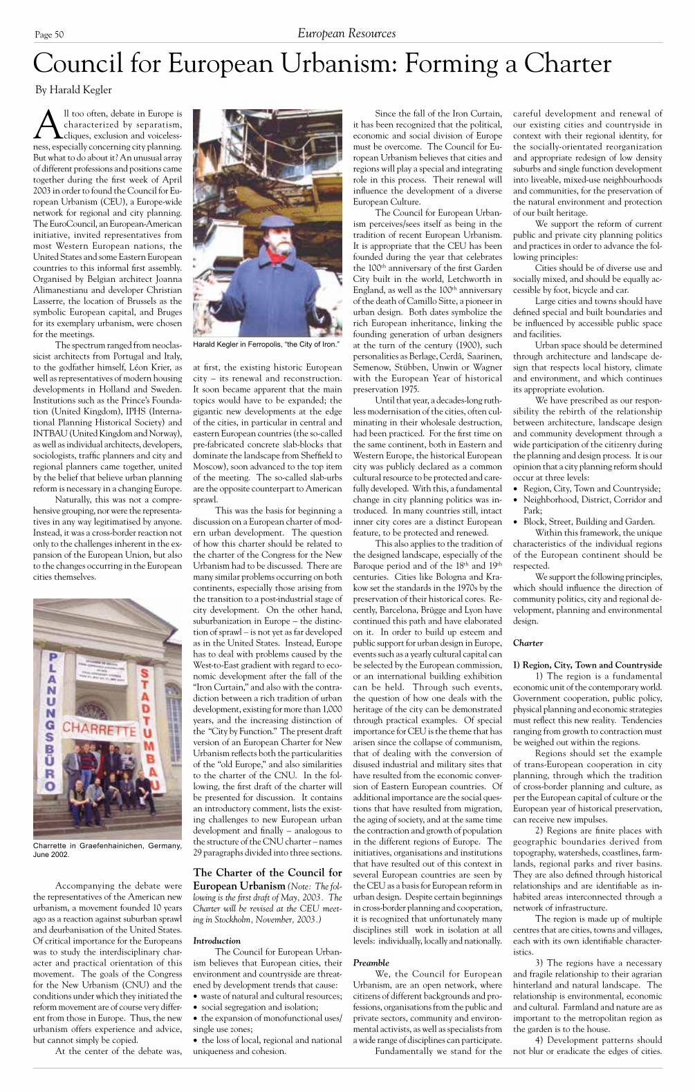
Page 50
at first, the existing historic European city – its renewal and reconstruction. It soon became apparent that the main topics would have to be expanded; the gigantic new developments at the edge of the cities, in particular in central and eastern European countries (the so-called pre-fabricated concrete slab-blocks that dominate the landscape from Sheffield to Moscow), soon advanced to the top item of the meeting. The so-called slab-urbs are the opposite counterpart to American sprawl.
This was the basis for beginning a discussion on a European charter of mod-ern urban development. The question of how this charter should be related to the charter of the Congress for the New Urbanism had to be discussed. There are many similar problems occurring on both continents, especially those arising from the transition to a post-industrial stage of city development. On the other hand, suburbanization in Europe – the distinc-tion of sprawl – is not yet as far developed as in the United States. Instead, Europe has to deal with problems caused by the West-to-East gradient with regard to eco-nomic development after the fall of the “Iron Curtain,” and also with the contra-diction between a rich tradition of urban development, existing for more than 1,000 years, and the increasing distinction of the “City by Function.” The present draft version of an European Charter for New Urbanism reflects both the particularities of the “old Europe,” and also similarities to the charter of the CNU. In the fol-lowing, the first draft of the charter will be presented for discussion. It contains an introductory comment, lists the exist-ing challenges to new European urban development and finally – analogous to the structure of the CNU charter – names 29 paragraphs divided into three sections.
IntroductionThe Council for European Urban-
ism believes that European cities, their environment and countryside are threat-ened by development trends that cause: waste of natural and cultural resources; social segregation and isolation; the expansion of monofunctional uses/single use zones; the loss of local, regional and national uniqueness and cohesion.
Since the fall of the Iron Curtain, it has been recognized that the political, economic and social division of Europe must be overcome. The Council for Eu-ropean Urbanism believes that cities and regions will play a special and integrating role in this process. Their renewal will influence the development of a diverse European Culture.
The Council for European Urban-ism perceives/sees itself as being in the tradition of recent European Urbanism. It is appropriate that the CEU has been founded during the year that celebrates the 100th anniversary of the first Garden City built in the world, Letchworth in England, as well as the 100th anniversary of the death of Camillo Sitte, a pioneer in urban design. Both dates symbolize the rich European inheritance, linking the founding generation of urban designers at the turn of the century (1900), such personalities as Berlage, Cerdâ, Saarinen, Semenow, Stübben, Unwin or Wagner with the European Year of historical preservation 1975.
Until that year, a decades-long ruth-less modernisation of the cities, often cul-minating in their wholesale destruction, had been practiced. For the first time on the same continent, both in Eastern and Western Europe, the historical European city was publicly declared as a common cultural resource to be protected and care-fully developed. With this, a fundamental change in city planning politics was in-troduced. In many countries still, intact inner city cores are a distinct European feature, to be protected and renewed.
This also applies to the tradition of the designed landscape, especially of the Baroque period and of the 18th and 19th centuries. Cities like Bologna and Kra-kow set the standards in the 1970s by the preservation of their historical cores. Re-cently, Barcelona, Brügge and Lyon have continued this path and have elaborated on it. In order to build up esteem and public support for urban design in Europe, events such as a yearly cultural capital can be selected by the European commission, or an international building exhibition can be held. Through such events, the question of how one deals with the heritage of the city can be demonstrated through practical examples. Of special importance for CEU is the theme that has arisen since the collapse of communism, that of dealing with the conversion of disused industrial and military sites that have resulted from the economic conver-sion of Eastern European countries. Of additional importance are the social ques-tions that have resulted from migration, the aging of society, and at the same time the contraction and growth of population in the different regions of Europe. The initiatives, organisations and institutions that have resulted out of this context in several European countries are seen by the CEU as a basis for European reform in urban design. Despite certain beginnings in cross-border planning and cooperation, it is recognized that unfortunately many disciplines still work in isolation at all levels: individually, locally and nationally.
PreambleWe, the Council for European
Urbanism, are an open network, where citizens of different backgrounds and pro-fessions, organisations from the public and private sectors, community and environ-mental activists, as well as specialists from a wide range of disciplines can participate.
Fundamentally we stand for the
careful development and renewal of our existing cities and countryside in context with their regional identity, for the socially-orientated reorganization and appropriate redesign of low density suburbs and single function development into liveable, mixed-use neighbourhoods and communities, for the preservation of the natural environment and protection of our built heritage.
We support the reform of current public and private city planning politics and practices in order to advance the fol-lowing principles:
Cities should be of diverse use and socially mixed, and should be equally ac-cessible by foot, bicycle and car.
Large cities and towns should have defined special and built boundaries and be influenced by accessible public space and facilities.
Urban space should be determined through architecture and landscape de-sign that respects local history, climate and environment, and which continues its appropriate evolution.
We have prescribed as our respon-sibility the rebirth of the relationship between architecture, landscape design and community development through a wide participation of the citizenry during the planning and design process. It is our opinion that a city planning reform should occur at three levels: Region, City, Town and Countryside; Neighborhood, District, Corridor and
Park; Block, Street, Building and Garden.
Within this framework, the unique characteristics of the individual regions of the European continent should be respected.
We support the following principles, which should influence the direction of community politics, city and regional de-velopment, planning and environmental design.
Charter
I) Region, City, Town and Countryside1) The region is a fundamental
economic unit of the contemporary world. Government cooperation, public policy, physical planning and economic strategies must reflect this new reality. Tendencies ranging from growth to contraction must be weighed out within the regions.
Regions should set the example of trans-European cooperation in city planning, through which the tradition of cross-border planning and culture, as per the European capital of culture or the European year of historical preservation, can receive new impulses.
2) Regions are finite places with geographic boundaries derived from topography, watersheds, coastlines, farm-lands, regional parks and river basins. They are also defined through historical relationships and are identifiable as in-habited areas interconnected through a network of infrastructure.
The region is made up of multiple centres that are cities, towns and villages, each with its own identifiable character-istics.
3) The regions have a necessary and fragile relationship to their agrarian hinterland and natural landscape. The relationship is environmental, economic and cultural. Farmland and nature are as important to the metropolitan region as the garden is to the house.
4) Development patterns should not blur or eradicate the edges of cities.
Council for European Urbanism: Forming a CharterBy Harald Kegler
Harald Kegler in Ferropolis, “the City of Iron.”
All too often, debate in Europe is characterized by separatism, cliques, exclusion and voiceless-
ness, especially concerning city planning. But what to do about it? An unusual array of different professions and positions came together during the first week of April 2003 in order to found the Council for Eu-ropean Urbanism (CEU), a Europe-wide network for regional and city planning. The EuroCouncil, an European-American initiative, invited representatives from most Western European nations, the United States and some Eastern European countries to this informal first assembly. Organised by Belgian architect Joanna Alimanestianu and developer Christian Lasserre, the location of Brussels as the symbolic European capital, and Bruges for its exemplary urbanism, were chosen for the meetings.
The spectrum ranged from neoclas-sicist architects from Portugal and Italy, to the godfather himself, Léon Krier, as well as representatives of modern housing developments in Holland and Sweden. Institutions such as the Prince’s Founda-tion (United Kingdom), IPHS (Interna-tional Planning Historical Society) and INTBAU (United Kingdom and Norway), as well as individual architects, developers, sociologists, traffic planners and city and regional planners came together, united by the belief that believe urban planning reform is necessary in a changing Europe.
Naturally, this was not a compre-hensive grouping, nor were the representa-tives in any way legitimatised by anyone. Instead, it was a cross-border reaction not only to the challenges inherent in the ex-pansion of the European Union, but also to the changes occurring in the European cities themselves.
Accompanying the debate were the representatives of the American new urbanism, a movement founded 10 years ago as a reaction against suburban sprawl and deurbanisation of the United States. Of critical importance for the Europeans was to study the interdisciplinary char-acter and practical orientation of this movement. The goals of the Congress for the New Urbanism (CNU) and the conditions under which they initiated the reform movement are of course very differ-ent from those in Europe. Thus, the new urbanism offers experience and advice, but cannot simply be copied.
At the center of the debate was,
Charrette in Graefenhainichen, Germany, June 2002.
European Resources
The Charter of the Council for European Urbanism (Note: The fol-lowing is the first draft of May, 2003. The Charter will be revised at the CEU meet-ing in Stockholm, November, 2003.)

Page 51Council Report V
This is of particular importance in deal-ing with the necessary redevelopment of large industrial prefabricated housing areas, the so-called “Slab-Urbs,” as well as to the conversion of disused industrial and military sites.
Regions should develop strategies to encourage such infill development over peripheral expansion. The existing, intact inner-city areas of European cities should be protected and carefully renewed.
5) Where appropriate, new devel-opment contiguous to urban boundaries should be organized as neighbourhoods and districts and be integrated within the existing urban pattern. Noncontigu-ous development should be organized as towns and villages with their own urban edges, and planned for a balance of jobs, recreation and housing and not just as bedroom suburbs. Gated communities must be avoided through sensible alter-natives, which still respect security and public accessibility.
6) The development and rede-velopment of towns and cities should respect historical patterns, precedents and boundaries.
7) The broad and integrated design of the cultural landscape should be en-couraged as part of the ongoing transition of European agriculture into a regional service economy. This applies not only to fallow agricultural land, but also to in-dustrial, military and inner-city wasteland.
8) Cities and towns should bring into proximity a broad spectrum of public and private uses to support a re-gional economy that benefits people of all incomes. Affordable housing should be distributed throughout the region to match job opportunities and to avoid concentrations of poverty.
9) The physical organization of the region should be supported by a framework of transportation alternatives. Transit, pedestrian and bicycle systems should maximize access and mobility throughout the region while reducing dependence on the automobile.
10) Revenues and resources should be shared more cooperatively among the municipalities and centres within regions to avoid destructive competition for tax base and to promote rational co-ordination of transportation, recreation, public services, housing and community institutions.
II) Neighbourhood, District, Corridor and Park
11) The neighbourhood, the district and the corridor are the essential elements of development and redevelopment in the region. They form identifiable areas that encourage citizens to take responsibility for their maintenance and evolution.
12) Neighbourhoods should be compact, pedestrian-friendly and mixed-use. Neighbourhoods are the smallest
units within a region. Districts generally emphasize a special single use, for example a nature park, industrial core or infra-structure, and should follow the principles of neighbourhood design when possible, or at least correspond with these special uses. Corridors are regional connectors of neighbourhoods, districts and even cities; they range from boulevards and rail lines to rivers and parks, and include landscape, environmental and economic networks.
13) Many activities of daily living should occur within walking distance, allowing independence to those who do not drive, especially the elderly and the young. Interconnected networks of streets should be designed to encourage walking, reduce the number and length of automobile trips, and conserve energy.
14) Within neighbourhoods, a broad range of housing types and price levels can bring people of diverse ages, races and incomes into daily interaction, strengthening the personal and civic bond essential to an authentic community.
15) Transit corridors, when properly planned and coordinated, can help orga-nize metropolitan structure and revitalize urban centres. In contrast, highway cor-ridors should not displace investment from existing centres.
16) Appropriate building densities and land uses should be within walking distance of transit stops, permitting public transit to become a viable alternative to the automobile. Public transit needs to be of good quality and offered at an af-fordable price.
17) Civic, institutional and com-mercial activity should be embedded in neighbourhoods and districts, not isolated in remote, single-use complexes. Schools should be sized and located to enable children to walk or bicycle to them.
18) The economic health and har-monious evolution of neighbourhoods, districts and corridors can be improved through graphic urban design codes and consensual guidelines that serve as pre-dictable guides for change.
19) A range of parks, agricultural areas, green connectors, as well as play-ing fields and community gardens should be distributed within neighbourhoods. Conservation areas and open lands should be used to define and connect different neighbourhoods and districts.
III) Block, Street, Square, Building and Garden
20) A primary task of all urban architecture and landscape design is the physical definition of streets and public spaces as places of shared use. The de-sign must reflect this as well as add to the cultural heritage.
21) Individual architectural projects should be seamlessly linked to their sur-roundings. This issue transcends style. Urban architecture should be diverse and
be receptive to the new. However, at the same time, it should respect its history and its urban context.
22) The revitalisation of urban places depends on safety and security. The design of streets and buildings should reinforce safe environments, but not at the expense of accessibility and openness.
23) In the contemporary metropo-lis, development must adequately accom-modate automobiles. It should do so in ways that respect the pedestrian and the form of public space.
24) Streets and squares should be safe, comfortable and interesting to the pedestrian. Properly configured, they encourage walking and enable neighbours to know each other and promote public activities.
25) Architecture and landscape design should grow from local climate, topography, history and building practice, and should harmonize with and enrich the existing.
26) Civic buildings and public gathering places require important sites to reinforce community identity and the culture of democracy. They deserve distinctive form, because their roles are different from that of other buildings and places that constitute the fabric of the city.
27) Gardens are an elemental part of open space near to housing. They should be social and ecological, but also economic refuges within the city. They are to be, as in the tradition of the 19th century, more than just visual objects: they are to be so designed that they invite the use by people on an everyday basis.
28) All building should provide their inhabitants with a clear sense of location, weather and time. Natural methods of heating and cooling can be more resource efficient than mechanical systems. For heating and cooling, resource effective systems should be used, includ-ing, if possible, regenerative technologies.
29) Preservation and renewal of historic buildings, districts and landscapes affirm the continuity and evolution of urban society. They form the essential foundation for future development.
The Next StepsThus, the foundation has been laid
for the Council of European Urbanism (CEU). The next meeting is scheduled for November in Stockholm, Sweden. The charter and list of projects that incorporate the goals of the charter are being prepared, which will stimulate further debate.
Whether neoclassicist or Bauhaus, developer or contractor, city sociologist or concrete slab-block modernizer, all find in these points of the Charter a basis for stra-tegic reform. In particular, the openness of the network to all who have an interest in a renewal of urbanism is emphasized.
EuroCouncil in Bruges, April 2003. Photo: Ben Bolgar.
No membership in a particular profession, no stylistic association, nor position in so-ciety may determine who can participate.
First reactions to this draft show that it not only stimulates the debate in Europe, but at the same time initiated the question of reforming the CNU charter. This is a good example of transatlantic cooperation.
The topic of the next CEU meeting will be developing areas of “good mixed-use” in cities. This aims to take up one of the central challenges in urban develop-ment of the 21st century: the abolition of the idea of a “City by Function” created by the modern age. Separation of the urban functions of living, working, relaxing and traffic has been propagated to a large extent by the Athens Charter of 1933. It is no accident that the problematic “City by Function“ becomes the central ques-tion of the first conference of the CEU: Seventy years ago the Charter of Athens was announced and thus, the credo of a “new urban planning,” which continues to have effects up to now, was born. It is time for a radical course change.
In face of social and structural stultification, especially of the slab-urbs, but also of the immense flows of traffic created by the idea of “City by Function,” the call for an alternative becomes louder and louder. “Mixed-use“ seems to be the solution. But is it really the solution? The existing city of the industrial modern age cannot be changed into a town of a type known from the preindustrial age with a single stroke of a pen. It is not possible to revive the traditional town simply by demolishing slab-urbs in the periphery of Paris or Berlin. Approximately one third of all European people live in the separated suburbs. This represents one of the greatest challenges to European city planning, especially in Eastern Eu-rope. Passing the charter in November in Stockholm will not solve the problem in any case. On the contrary, it will be the beginning of the real task. Nevertheless, the charter will be a solid foundation for transforming European city planning.
The proposal of the CEU-Charter is presented by the members of the CEU German-Net: Harald Bodenschatz, Harald Kegler, Karl Heinz Maschmeier, Duane Phillips, Wolfgang Serbser.
Contact:harald_kegler@yahoo.comwww.industrielles-gartenreich.comwww.dr-kegler.de www.charrette.de
The EuroCouncil attends an evening presentation by Dr. Wolfgang Sonne. Bruges, April 2003. Photo: Laurence Aurbach

Page 52The Tow
n Paper309 M
ain StreetG
aithersburg, MD
20878
PR
SR
T STD
U.S
. PO
STA
GE
PAID
SU
BU
RB
AN
MD
Perm
it #1722Knight Program in Community Building
The Knight Program in Community Building at the University of Miami School of Architecture ad-dresses today’s urgent issues associated with community building, including the complex problems of suburban sprawl and inner-city disinvestment. The program’s goal is to advance the knowledge and practice of New Urbanism and Smart Growth across disciplines through an innovative series of initiatives. The program is funded by the John S. and James L. Knight Foundation, which promotes excellence in journalism worldwide and invests in the vitality of 26 U.S. Communities. The Knight Pro-gram extends the Knight Foundation’s commitment to community service with a mid-career program of professional development.
Key West Rooftops. Drawing by Martha de Quesada, University of Miami School of Architecture.
Scholars
The Knight Program offers schol-arships to promising students entering the University of Miami School of Architecture gradu-ate program in suburb and town design. This unique program provides cutting edge training in the techniques of New Urbanism. Scholars take part in seminars, workshops, research and publi-cations produced by the Knight Program.
Symposia/Charrettes The program sponsors seminars, conferences and an annual char-rette in a Knight city. Past seminars include the “Transect Seminar” at Yale University, “New Plazas for New Mexico” and “Civic Art 2002.” The Knight Program’s first charrette focused on the revitalization of an inner-city neighborhood in Macon, Ga. Its 2002 charrette was on the Evergreen-Eastridge area of San Jose and its 2003 charrette will occur in Coates-ville, Penn.
Publications
A variety of publications on topics of community building, smart growth and new urban-ism are sponsored by the Knight Program. These include the quarterly New Urban Post, the semi-annual Design Council Re-port, books, journals and other material. The Knight Fellows’ projects are published in case stud-ies, research and journal articles on a variety of related topics.
♦ ♦ ♦♦
ContactCharles C. Bohl, [email protected]/knight
FellowsEach year, the Knight Program selects 12 mid-career profession-als from diverse fields to take part in intensive community-building workshops, seminars and a char-rette, while pursuing indi-vidual projects. Fellows are selected from fields such as architecture, planning, housing, community development, real estate, journalism, transporta-tion and human services.
Pushing the Boundaries of New Urbanism and Smart Growth
CNU XIIJune 24 - 27, 2004
Developing Better Cities and Towns Chicago, IllinoisPalmer House Hilton Hotel

![Council Tax Guidance Manual · K v Wolverhampton City Council, F v Wychavon District Council and J v South Staffordshire Council [VTE, 4635M121095/176C and others 23 April 2014] Kendrick](https://static.documents.pub/doc/80x56/5ffeee0b8d7b4d6a5d6c8e0b/council-tax-guidance-manual-k-v-wolverhampton-city-council-f-v-wychavon-district.jpg)


![CANADIAN COUNCIL FOR REFUGEES v. CANADA … COUNCIL FOR REFUGEES v. CANADA [2009] 3 F.C.R. A-37-08 2008 FCA 229 Her Majesty The Queen (Appellant) v. Canadian Council for Refugees,](https://static.documents.pub/doc/80x56/5b30b6737f8b9ab5728b92e3/canadian-council-for-refugees-v-canada-council-for-refugees-v-canada-2009-3.jpg)

![COI Update Vol . 203 - ARC · The New Humanitarian, /v }v P}UZu]o] ] [ }o }v Z (µ oo }uuµv] Ç ] v , 2 October 2019 Security Council, Report of the Secretary -General of the UN:](https://static.documents.pub/doc/80x56/5ece4ed18658e21cd7545645/coi-update-vol-203-arc-the-new-humanitarian-v-v-puzuo-o-v-z-.jpg)


