County of Los Angeles CHIEF ADMINISTRATIVE OFFICE 713 KENNETH HAHN HALL t9F ADMINISTRATION -LOS ANGELES, CALIFORNIA 90012 (213) 974-1101 http://cao.co.la.ca.us DAVID E.JANSSEN Chief Administrative Officer Board of Supervisors GLORIA MOLINA First District June 13, 2006 YVONNE B. BURKE Second District ZEV YAROSLAVSKY Third District The Honorable Board of Supervisors County of Los Angeles 383 Kenneth Hahn Hall of Administration 500 West Temple Street Los Angeles, CA 90012 DON KNABE Fourth District MICHAEL D. ANTONOVICH Fifth District Dear Supervisors: CONSENT TO CONVEY A PORTION OF COUNTY-OWNED PARK REAL PROPERTY TO THE CITY OF LA MIRADA FOR PARK PURPOSES LA MIRADA REGIONAL PARK, LA MIRADA (FOURTH DISTRICT) (4-VOTES) JOINT RECOMMENDATION WITH THE DEPARTMENT OF PARKS AND RECREATION THAT YOUR BOARD: 1. Find that an 18-acre portion of the County of Los Angeles (County) 'owned park real property commonly known as La Mirada Regional Park (Park), legally described in Exhibit A, to the Real Property Conveyance Agreement (Attachment A) is not required for County use. 2. Certify that the Board, as a responsible agency 1 under the. California Environmental Quality Act (CEQA), has independently considered and reached its own Conclusions regarding the environmental effects of the proposed project (as described below) and the Mitigated Negative Declaration and Mitigation Monitoring and Reporting Program (Attachment B) adopted by the City of La Mirada (City), as lead agency; determine that the documents adequately address the environmental impacts of the proposed project; find that your Board . has complied with the requirements of CEQA with respect to the process for a responsible agency and adopt by reference the City's Mitigated Negative Declaration and Mitigation Monitoring and Reporting Program. 3. Approve and instruct the "Mayor of the Board to sign, upon presentation and subsequent to the documents being approved as to form by County Counsel, the Real Property Conveyance Agreement (Agreement) in a format similar to Attachment A and the Quitclaim Deed. 'To Enrich Lives Through Effective Arid Caring Service"
Transcript
County of Los AngelesCHIEF ADMINISTRATIVE OFFICE
713 KENNETH HAHN HALL t9F ADMINISTRATION -LOS ANGELES, CALIFORNIA 90012(213) 974-1101
http://cao.co.la.ca.us
DAVID E.JANSSENChief Administrative Officer
Board of SupervisorsGLORIA MOLINAFirst District
June 13, 2006 YVONNE B. BURKESecond District
ZEV YAROSLAVSKYThird District
The Honorable Board of SupervisorsCounty of Los Angeles383 Kenneth Hahn Hall of Administration500 West Temple StreetLos Angeles, CA 90012
DON KNABEFourth District
MICHAEL D. ANTONOVICHFifth District
Dear Supervisors:
CONSENT TO CONVEY A PORTION OF COUNTY-OWNED PARKREAL PROPERTY TO THE CITY OF LA MIRADA FOR PARK PURPOSES
LA MIRADA REGIONAL PARK, LA MIRADA(FOURTH DISTRICT) (4-VOTES)
JOINT RECOMMENDATION WITH THE DEPARTMENT OF PARKS ANDRECREATION THAT YOUR BOARD:
1. Find that an 18-acre portion of the County of Los Angeles (County) 'owned park
real property commonly known as La Mirada Regional Park (Park), legallydescribed in Exhibit A, to the Real Property Conveyance Agreement
(Attachment A) is not required for County use.
2. Certify that the Board, as a responsible agency 1 under the. CaliforniaEnvironmental Quality Act (CEQA), has independently considered and reachedits own Conclusions regarding the environmental effects of the proposed project(as described below) and the Mitigated Negative Declaration and MitigationMonitoring and Reporting Program (Attachment B) adopted by the City of
La Mirada (City), as lead agency; determine that the documents adequatelyaddress the environmental impacts of the proposed project; find that your Board
. has complied with the requirements of CEQA with respect to the process for aresponsible agency and adopt by reference the City's Mitigated NegativeDeclaration and Mitigation Monitoring and Reporting Program.
3. Approve and instruct the "Mayor of the Board to sign, upon presentation andsubsequent to the documents being approved as to form by County Counsel, theReal Property Conveyance Agreement (Agreement) in a format similar toAttachment A and the Quitclaim Deed.
'To Enrich Lives Through Effective Arid Caring Service"
. The Honorable Board of SupervisorsJune 13, 2006Page 2
PUR"POSE/JUSTIFICATION OFRECOMNIENDED ACTION
The purpose of the recommended action .is to grant a request by the City to convey titletoa portion of the Park consisting of approximately 18 acres to accommodate theconstruCtion of the City's new Aquatic Center. The proposed conveyance is authorizedby SeCtion 25365 of the California Government Code, which allows for real propertyconveyances to other governmental agencies if the real property is not required forCounty use.
The subject Park is not required for County use because the use, as established by theCounty (Le., park or recreational purposes), wil not change and exclusive Countycontrol is.. not required to insure that the established use wil be maintained. Theproposed Aquatic Center wil. not only' continue but expand and enhance the Parkservices and uses currently offered to residents. Moreover, the City has agreed tomaintain the real property for park or recreational purposes in perpetuity.
The City's new Aquatic Center wil be open and. available to residents of incorporatedanddunincorporated County territorY and there shall be no discrimination against orpreference, gratuity, bonus or other benefit. given residents of La Mirada not equallyaccorded to residents of Los Angeles County.
. Implementation of Strateqic Plan Goals
The Countywide Strategic Plan directs that we provide the public with qualiy servicesthat are both beneficial and responsive (Goal 1 ). Conveyance of park real propert toanother governmental agency for continued operation, use and enjoyment by Countyconstituents, as a park or recreational area in perpetuity with the addition of newfacilities for use by County residents, is consistent with that Goal. .
1
FISCAL IMPACT/FINANCING
The gratis conveyance of the subject Park wil have no significant. fiscal impact to theCounty.
FACTS AND PROVISIONS/LEGAL REQUIREMENTS
The parcel of real property which comprises the Park was purchased by the County in1956 and currently covers approximately 100 àcres. The Park is located entirely withinCity boundaries, bounded on the north by Foster Road, on the east by Adelfa Drive, onthe sòuth by Alicante Road and on" the west by Olive Lawn Memorial Park and the CivicCenter complex. It has multiple uses and provides a wide range of recreational andcultural opportunities to the community at large.
The Honorable Board of SupervisorsJune 13, 2006Page 3
The-proposed Aquatics Center is considered by the City to be a key step in its ongoingdevelopment of the Civic Center complex, which serves the community by providing awide variety of recreational, social and cultural services to the public.
The project, as proposed by the City, wil replace the County's aging community poolcomplex and provide a full range of recreational, instructional, therapeutic andcompetitive aquatic programs.
The outdoor facilty wil include a 50-meter pool, a 25-yard pool, a spa, and family funarea, as well.as. other amenities to host special community events and group activities.The projected annual. attendance at the proposed facilty is approximately 150,000
people.
The proposed transaction wil be governed by the terms and cönditions as set forth inAttachment A which, among other things, outlines certain required actions by the City.should existing County faciliies be displaced as a result of the proposed construction,The required aCtions shall be performed at the City's sole cost and expense andinclude, among othêrs:
· Reimbursement of the County's cost incurred to relocate set-up of threereplacement children's play areas. While the Agreement limits reimbursement to$153,631, costs, already incurred by the County, are substantially less.
· Relocation and construction of a new permanent maintenance facilty inconjunction with the proposed Park master plan.
· Demolition of the existing community pool complex and replacement with usesconsistent with recreational activities.- .
· Reconfiguration and relocation of the existing disc golf course pursuant to plansand specifications provided by the County.
· Relocation of the existing picnic tables and barbeque braziers.
Conveyance of title wil be consummated by quitclaim deed. In accordance with yourBoard's policy, the deed reserves the mineral rights in the subject Park to the County.
In addition to the title transfer to the City, the City wil exchange their current perpetualeasement on a portion of the Park being retained by the County for a revocable parkingeasement. This replacement of the easement wil allow the County to make changes tothe Park in the future as recreational needs change.
The Honorable Board of SupervisorsJune 13, 2006Page 4
Additionally, the Agreement wil allow the grant of an easement for utility purposeswhich wil recognize the long existing utility corridor used by the City for purpose ofutility feeds for various City parcels that surround the Park.
The City Council voted to accept conveyance of title to the subject Park in its current"as is" condition with no guarantees or warranties by the County. Notice of your Board'sintent to convey a portion of the Park has been published in accordance with
Government Code Section 6061. Prior to presentation for signature, County Counselwil review the Agreement and Quitclaim Deed related to the conveyance and wilapprove those documents as to form.
ENVIRONMENTAL DOCUMENTATION
The City, in its- role as lead agency in matters pertaining to compliance with theCalifornia Environmental Quality Act (CEQA), by Resolution No. 06-26 adopted by theCity Council on May 23, 2006, found and determined that with the imposition ofmitigation measures as a condition of approval of the Aquatic Center project there wasno substantial evidence that the project would have a significant effect on theenvironment; found that the Mitigated Negative Declaration reflected the independentjudgment of the City; approved the Mitigated Negative Declaration; and found that theproject wil have no adverse effect on fish and wildlife resources. As part of the scopeof the Mitigated Negative Declaration, a Mitigation and Reporting Program has beenincluded. This program wil-be implemented and monitored by the City.
With respect to your Board's approval of the property conveyance described herein, theCounty also acts as a responsible agency for the purposes of CEQA, and therefore, werecommend that your. Board independently consider and adopf the Mitigated NegativeDeclaration and the Mitigation Monitoring and Reporting Program (Attachment B).
IMPACT ON CURRENT SERVICES (OR PROJECTS)
The recommended action wil serve to maintain recreational opportunities for the publicand inasmuch as the City is obligated to assume responsibilty for the various swimmingactivities previously provided by the County's Department of Parks and Recreation,there wil be no adverse impact to the public as a result of the curtailment on any currentCounty services at the Park. The Department pf Parks and Recreation is inconcurrence with the proposed conveyance of title.
The Honorable Board.of SupervisorsJune 13, 2006Page 5
CONCLUSION
It is requested that the Executive Officer, Board of Supervisors, return two certifiedcopies of the Minute Order, and the adopted, stamped Board letter to the CAOReal Estate Division at 222 South Hil Street, 3rd Floor, Los Angeles, CA 90012 forfurther processing. Additionally, please forward a copy of the adopted, stamped Boardletter to the Department of Parks and Recreation, Planning Division, 510 South VermontAvenue, Los Angeles, CA 90020.
~~A ID E. JANSSEN~""
Chief Administrative OfficerRUSS GUINEY, DirectorDepartment of Parks and Recnaation
DEJ:WLDCB:RL:dd
Attachments (2)
c: County Counsel
Department of Parks and Recreation
la Mirada Park.b.doc
..
REAL PROPERTY CONVEY ANCE AGREEMENT
THIS REAL PROPERTY CONVEYANCE AGREEMENT ("Agreement") is madeand_entered into as of the day of , 2006, by and between theCOUNTY OF LOS ANGELES ("Gràntot'), and the CITY OF LA MIRADA ("Grantee").Based upon the mutual consideration provided for herein, Grantorand Grantee agreeas follows:
1. Sale and Purchase, Grantor is the fee owner of certain real property locatedwithin La Mirada Regional Park (the"Park") in the City of La Mirada, County of LosAngeles, State of California and legally described in Exhibit A, attached hereto andincorporated herein by reference, (the "Propert). Grantor desires to convey thePropert to Grantee, and Grahtee dE;sires to accept the Propert from Grantor, for theconsideration and on the terms and conditions hereinafter set forth.
2. Purchase Price. The pÜrchase price ("Purchase Price") for the Propert isto be paid partially in cash and partially as non-cash consideration. The Purchase Priceshall be comprised ofthefoiiÖwing:
a) CASH PAYMENTGrantee shallpåyGtantor the amount of $153,631 on or before July15,2006 for Gråntor's costs incurred to construct a portion of threechildren's play areas at. the'.Park. Said payment shall be by checkpayable to County of Los Angeles delivered to Grantor's address setforth in Section 14 hereof.
Grantee, basedüpona preliminary plan prepared by Grantor and atGrantee's sole cost and expense, shall CÖnstruct sidewalks and otherimprovements on the .Park required as a result of the realignment of
the propert. lineanCl tlie necessity to make the newly constructedchildren's play areas compliant with ADA accessibility requirements., . - ',-:', ,',' - . .,' : .---, ..' . -' , ...Grantee snall':retainapröfessionalto produce construction documents
- withinfifteendåys'Of rèceipt of Grantee's preliminary plan andthé-tèaffeY,'GraHtée:shall make its best faith effort to timely constructthe sidewalkànd. other. improvements to coincide with Grantotscompletion ofthe children's play areas.
b) MAINTENANCE FACILITYGrantee shaH construct a permanent maintenance facilty pursuant toconstructiOn drawings developed by Grantee and approved by Grantor(the "Maintenance Facilty") in a location within La Mirada RegionalPark. The scope of work detailng the improvements comprising the
Maintenance Facility is attached hereto and incorporated herein asExhibit B. Grantor and Grantee agree that the Maintenance Faciltywil be situated in a location mutually satisfactory to both parties as
determined by the Park Feasibilty Study, as that term is defined
1
Sale and Purchase Agreement
herein. In the event the Park Feasibility Study is not timely completed,then Grantor shalf choose the location for the Maintenance Facilty.The parties agree that construction of the Maintenance Facilty shallcommence within 90 days of the date the site location is Selected andthat evidence of such commencement shall be at a minimum,Grantee's approval of a contract with an architect hired to produce theconstruction drawings for the Maintenance Facilty but in no event shallthe Maintenance Facility be completed more than 18 months followingthe completion of the Aquatic Center as evidenced by the issuance ofa certificate of occupancy for said facility (the date of which certificateshall be the "Aquatic Center Completion Date").
c) EXISTING SWIM FACILITIESNo later than one year after the Aquatic Center Completion Date,
Grantee shall demolish the existing pool areas and bath housefacilties at the Park, which are depicted on the map attached heretoand incorporated herein as Exhibit C (collectively, the "SwimFacilities"), and replace said Swim Facilities with uses designated in.the Park Feasibilty Study, as that term is defined herein. In the.eventthe Park Feasibilty Study has not been adopted prior to the completionof demolition of the Swim Facilities, Grantee shall complete theinstallation of lawn area. on the entire Swim Facilties site includingadequate irrigation systems. The' scope of work pertaining to thedemolition of the Swim Facilties is attached hereto and incorporatedherein as Exhibit D. .
d) DISC GOLF COURSENo later than 30 days after the date Grantor provides Grantee a planoutlining the realignment of the existing disc golf course within the Park(the "Disc Golf Plan"), Grantee
shall commence to reconfigure the
existing disc golf course at the Park pursuant to the Disc Golf Planpro~ided by Grantor, incluqing without limitation,. redesign andralocation of the discgolftargetsand.pads; :cJis~(golf tees and concrete
_ tee pads and disc golf signs (incluaing replacement. of component.parts) in a manner satisfactory to Grantor and in compliance with theDisc Golf Plan. At a minimum, the parties agree that the reconfiguredcourse wil maintain an acceptable safety and skil level not lower thanthat of the existing course. In this instance, commencement of workshall be deemed to occur upon Grantee's issuance of a bid packagesuitable for a contractor to provide Grantee with a construction bid forthe work required. In no event shall the improvements associated withthe Disc Golf Plan be completed" later than the Aquatic Center
Completion Date.
2Sale and Purchase Agreement
e) PICNIC TABLES AND BARBEQUE AREAGrantee, at Grantee's sole cost and expense, shall provide and installa minimum of 12 but not more than 18 concrete picnic tables and up to6 BBQ braisers in locations determined by Grantor. The work shall bedone in accordance with the scope attached hereto and incorporatedherein as Exhibit K and Grantee agrees to use its best faith efforts toinstall these features on or before August 15, 2006. Any costs toprepare the relocated picnic area shall be the sole responsibilty ofGrantee.
f) RESTROOM FACILITIESIn the event Grantee's construction of the Aquatic Center causes
Grantor to close the restroom building located adjaceht to the Propert(the "Existing Adjacent Restroom"), Grantee shall post adequatesignage indicating that replacement restroom' facilities (the"Replacement Restroom") are located in a facilty maintained by
Grantee that is not more than 500 feet from the Existing AdjacentRestroom. Grantee shall provide unobstructed access to the.Replacement Restroom during all times that the Park is open to thepublic.
g) SLOPE MAINTENANCETo the extent any grading of the Propert encroaches onto the Park,then prior to initiating any such grading activities, Grantee shall obtainGrantots express written consent to the proposed grading. As acondition of such consent of Grantor, Grantee shall accept sole
responsibilty in perpetuity and using standards generally accepted by. landscape professionals and in a manner satisfactory to the County for
the maintenance of any slope including any retaining structures built tosupport such slope that wil exist, partially or wholly, in the Park at a 2to 1 or higher grade over a distance of greater than 3 feet ("Qualified
Slope"). Additionally, Grantee shall accept responsibilty to cure anydrainage ;problems and/orresultant damageto'leal propert or
- improvements on the Park caused as a result of water run off from anyQualified Slope into the Park including the installation of drainagesystems or repair of landscape areas on the Park. . No later than 30days after the Aquatic Center is completed, Grantee shall deliver toGrantor legal descriptions for every Qualified Slope along with a SlopeMaintenance. Ägreementin the form attached hereto as Exhibit I andincorporated by this reference, executed by the appropriate City of LaMirada officials for recordation by Grantor.
3Sale and Purchase Agreement
h) GRANTSGrantee shall assume all claims, liabilities, obligations, and dutiesunder the provisions of Land Water and Conservation Fund (LWCF)grant agreement 06-01358, a copy of which is attached hereto andincorporated herein as Exhibit H. Grantee acknowledges that Grantorhas provided documents on the following State and Prop. A grants thatwere used to improve the Propert and/or Park: State Grant project
numbers 86-1-19058, 88-1-19127, 06-01358 and Proposition A grantnumbers 1270-94-0047, 1270-94-0046, 1270-98-0732, and 1270-95-0335. Grantee also acknowledges that Grantor may not be aware ofall grants that are applicable to the Propert, and it is Grantee's
obligation to conduct its own due diligence with respect to applicablegrants. Grantee agrees to be subject to any and all grants applicableto the Propert and shall assume all claims, liabilties; :obligations, andduties of such grants.
(i) MISCELLANEOUS AGREEMENTSBY GRANTEE:(i) Before June 2008, Grantee shall complete improvements to
. the Park consisting of an aquatic center offering swimming facilities forthe purpose of competition, instruction and recreation (the "AquaticCenter"), which wil at a minimum include: (1) one 25 yard teachingpool with a minimum and maximum depth of _ and _ feetrespectively; (2) one 50 meter competiion pool; (3) an enclosedbuilding with adequate changing and restroom facilties that issquare feetin size; (4) a picnic area that can accommodate 84 patronsand.(5) a themedrecreational swim area.
(ii) For ten consecutive weeks occurring from June 1 throughSeptember 1 of each calendar year, Grantee shall provide access from8:00 AM to 6:30 PM to a pool of at least 25 yards in length at the
Aquatic Center and staff sufficient to conduct swim programs, includinga recreational swim, so that County residents are afforded free ofcharge access to swimmingprogramssimíTar to those previously
_ provided by the Grantor.atthe Park. .
(Hi) Effective upon the date of this Agreement and continuinguntil such time as the Maintenance Facility is completed by Grantee, ,and at no cost whatsoever to Grantor, Grantee shall provide Grantor'scontractor engaged in maintaining the Park unobstructed access to aparcel of land located on Stage Road, south and east of the southernterminus of Biola, La Mirada. Said parcel shall consist of: (1) 12,000square feet of fenced and secured yard area; (2) one secured
office/storage/r~pair structure of at least 450 square feet; (3) anemergency wash station constructed in compliance with Cal OSHAstandards; (4) a potable water source and (5) one portable toilet whichshall be cleaned and serviced at least one time per week.
4Sale and Purchase Agreement
(iv) Grantee shall quitclaim to Grantor Grantee's interest in thatportion of the Park identified as Parcel 4 (the Library Parking Lot) in theinstrument recorded as No. 00-0052800 and attached hereto as ExhibitF and record in substitution thereof an easement from Grantor toGrantee similar in the form attached hereto as Exhibit E (RevocableParking Easement).
(v) The parties agree that Grantor shall reserve to itself the rightto use that portion of the Propert designated as Parcels 2 and 3 inExhibit F hereto and the parking lot adjacent to the existing gym facilityas described in instrument recorded as No. 96-1481948.on a non-
. exclusive basis for parking purposes.
(vi) Grantee shall repair, relocate. änd restore all utilties,irrigation systems, walkways, disc golf stations and security lightingsystems that are impacted by Grantee'~:' (A) construction of theAquatic Center, (B) construction of the Maintenance Facility describedin § 2(c) hereof, and (C) demolition of the existing Swim Faciliies (asdefined in § 2(d) hereof). All such repair and restoration work
completed pursuant hereto shall be done contemporaneously with
Grantee's construction of the improvements at the Park pursuant tothis Section 2 (e.g., the AqUátic Center~ Maintenance Facilty etc.).Grantee wil not initiate any actions pursuant tôthis Agreement that wilresult in the Park being adversely affected by the lack of adequateutilties.
(vii) . . As part of t~e constructionpf th.e Aquatic Center, Granteeshall plant 245speêirten trees, (minimum 24" box size) and 115 non-specimen trees in accordance . with the: .piantrnaterial list attachedhereto and incorporated herein as Exhibit G.
(vii) Grantee, with input ftomGrantor, shåU prepare a plan of theentire LafyiràdaHe~ionaIPar~ (ihcl~dingth~ 1Propert and the . park
- but.exclutlingth~ portion' of .th~Co4nty fCídlities thatcòmprisèsthe'County gÒlf courSe) detailng. the recreatiOnal amenities and. otherfeatures within the Park to be improved, established, and abandoned(the "Park Feasibility Study"). . The Park Feasibilty Study shall beinitiated by the Grant~e within. 90 days of. the Aquatic Center
Completion Date andthaf evidence of 5LJch initi.ationshall~e, at aminimum, Grantee's approval of a contract with a cqnsultant hired to
produce the Park Feasibilty Study.. . Grantee shall coordinate therequired community participation process and otherWise supervise the
drafting of the Park Feasibilty Study in accordance with generally
accepted standards employed by other government entities.
5Sale and Purchase Agreement
(x) Grantor agrees to grant Grantee an easement for utilitypurposes over a 'pórtion of the Park in the form attached hereto asExhibit J.
(xi) With respect to any and an construction by Grantee on thePark, the parties agree to cooperate and ensure compliance with theprovisions of the California Public Contract Code.
(xii) . Pursuant to this Agreement, Grantee wil use its best effortsto minimize disruption of service at the Park. For example, it is theintent of the parties to. minimize service interruption to the children'splay areas. Grantee and Grantor wil cooperate to ensure that therewil be replacement children's play areas available on the Park within areasonable time of Grantee's demolition of and/or disruption of use to
. the existing chilaren's play areas-on the Propert.
(xii) With re~pect to any and all construction by Grantee on thePark, all such construction. shall be done to the satisfaction of theGrantor and in accordance with the plans and instructions provided byGrantor. Grantee agrees to complete all of the constructioncontemplated hereinio a good workmanship manner and comply withexisting building codes including the. California Building Code and theUniform Bùilding _ Codes.
ü) DEFAULT BY GRANTEEIn the event that either part fails to comply with any of the conditionsset Jorth in this paragraph 2, such failure shall constitute a materialbreach of this Agreement, entitling the other part to any and allremedies available at law orin equity.
3. Costs. All costs and expenses, excluding Grantots expense to prepare,
negotiate, execute and implement this Agreement, related, to the transactionconternplate,d .by' this Agref3ment ,_~hall be paid. by ,Grantee, inclding the cost of a titlejnsuJançe,policy, " In' thejav~nt aiiy ,cost or expense is paid by Grantor, Grantee-shallimmedratélyduP9r Grantor's n¡~quest remit a check payable to the County of Los Angeles
in ah amourit equal to such costs and expenses.
4. Conveyance and _ Closinq Date. Grantor shall convey the Property toGrantee by quitclainideed (théIDeed"), subjectto: a) All taxes, interest, penalties andassessments of reco.rd assess~dbi.t not yet due, if any; and b) covenants, conditions,restrictions, reservations, easements, licenses, rights, and rights-of-way ot record, ifany, c) The express condition that the Grantee shall assume all claims, liabilties,obligations, and duties under the provisions af Land Water and Gonservation Fund(LWGF) grant agreement06-013"58 a copy of which is attached hereto and incorporatedherein as Exhibit H and any other applicable grants as set forth in paragraph 2(h)hereof, d) the express condition that at all times and under all conditions, the Propertand services, including the Aquatic Center, shall be open and available to residents of
6Sale and Purchase Agreement
incorporated and unincorporated ter(itqry and there shall be no discrimination against orpreference, gratuity, bonus or other benefit given residents of La Mirada not equallyaccorded to residents of Los Angeles County. e) the obligation that City of La Miradaoperate and maintain the Propert as a park or recreation facility; f) for 10 consecutiveweeks during the period commencing June 1 and terminating September 1 of eachcalendar year the Grantee shall provide access to a pool of at least 25 yards in length atthe Aquatic Center including staff sufficient to conduct the required programs, all at nocharge to residents of Los Angeles County for the purpose of providing: 1) swimminglessons for all levels of swimmers, and 2) recreational swim access every day duringsaid 10-week period., g) in the event that Grantee fails to comply with restrictions (d)and (e), then upon Grantee's failure tocure the issue of non-compliance within 30 daysof the date Grantor sends written notice to Grantee, or in the event such matter cannotbe cured within said 30 day period and in the event Grantee does not dilgently pursuethe required cure, then all right title and interest in and to the Propert shall revert backto Grantor upon Grantor's providing written notice to Grantee of its failure to comply withsaid restrictions and without any necessity of any other affirmativè action on the part ofGrantor. Grantor shall convey the Propert on or before the later of (i) June 15, 2006,or (ii) a date occurring five (5) days after the County of Los Angeles Board ofSupervisors approves the sale of the Propert.
5. Title; Grantee understands that the Propert is being conveyed without anywarranty regarding the condition of tite to ,the. Propert; Grantee' accepts all matters ofrecord and understanda. thatGrantor wil not provide a policy of tite insurance andmakes no representations or warranties. as to condition of title. Grantor recommendsthat Grantee retain, at Grantee's sole cost and expense, a licensed title company toissue a policy of title insurance.
6~ RecordinQ. Grantor shallpreparecthe Deed indicating title to the Propert tobe vested in the name of the Grantee as follows:.Gity of La Mirada, and shall cause theDeed to be recorded in the official records .of the Los Angeles County .Recorder uponthe execution of thisAgreement~
7.,DeIiV9rv.ioLDeed.,.GrantprsMall;transmit. to Granteèacopy of-the Deedstamped by the _Recorder, the original of which shall be mailed to the Gtantee by the.Recorder at the address for notice to Grantee pursuant to Section 14 hereof.
8. Condition of the Prooert. Grantee acknowledges that Grantee ispurchasing the Prop(:rt"asis,"solely in reliance on Grantee's own investigation, andthat no representation or warrarity of anykind whatsoever, express or implied, has beenmade by Grantor or Grantots agents. Any information given or disclosure made toGrantee by Grantor or Grantots agents concerning the Propert shall not constiute arepresentation or . warranty made by Grantor. Grantee has been given the fullopportunity to inspect the Propert prior to execution of this Agreement. Grantee shall.assume the cost and expense for the removal of all contaminated materials, toxic orhazardous substances, and asbestos, if any, on the Propert.
.,
7Sale and Purchase Agreement
Grantor has disclosed, tò Grantee the following information that impactsGrantee's use of the Propert:The requirement that the Propert shall not be converted to a use other than publicoutdoor recreation as provided in the LWCF agreement as detailed in Exhibit H. _
Grantee also acknowledges that it is aware of all zoning regulations, othergovernmental requirements, site and physical conditions, and all other matters affectingthe use and condition of the Propert, and Grantee agrees to accept the Propert insaid condition.
9. Mineral Riqhts. Grantor reserves to itself and excepts from the conveyancecontemplated herein all oil, gas, hydrocarbons, or other minerals in and under thePropert, without the use of the surface or subsurface, toa depthof500 feet, measured
i vertically, from the surface of the Propert.
10. Possession/Risk of Loss. All risk öf loss or damage with 'respect to the
Propert shall pass from Grantor to Grantee upon recordation of the Deed:
11. BrokeraQe Commission. Grantee and Grßntor hereby acknowledge andrepresent that there are no broker's commission or finder's fees due in connection withthe.' transaction contemplated by this Agreement. Each part shall indemnify and holdthe other part harmless from any claim of any broker, agent or finder, licensed orotherwise, claiming through, under or by reason of the conduct of either part withrespect to the transaction contemplated hereunder.
12. Conflcts. In the event of a conflict between the provisions of thisAgreement and the provisions of any other documents executed or agreement made orpurported to be executed or made between the parties prior to thedáte hereof, theprovisions contained in' this Agreement shall in allinstaricesgovètnand prevail.However, nothing in this Agreement shall be construed to 'negate any representationmade by Grantor in the Recreational Propert Acquisition Agreement dated June 11 ,
1996. between the parties hereto, as of the date such repres~ntations were given (i.e.,June' 11, 1996), to the. extent that the Hecreational Propert~Acciuisitiori Agreementremains in effect.
13. Assiqnment. Grantee shall not assign or attempt to assign this Agreement,or any rights hereunder, to any other person or entitywithoutthe Grantor's prior written '
consent. Any such assignment or purported assignment without the Grantor's priorwritten consent shall be null and void, and of no force and effect whatsoever.
14. Notices. All notices, demands and requests required or desired to be given'pursuant to this Agreement by either part shall be sent by United States Mail,registered or certified postage prepaid, and addressed to the parties as follows:
8Sale and Purchase Agreement
Grantor: County af Los AngelesChief Administrative Office222 South Hil Street, 3rdFIoorLos Angeles, CA 90012Attention: Carlos Brea, Manager
Propert Management
Grantee: City of La Mirada13700 La Mirada BoulevardLa Mirada, CA 90638Attention: Andrea Travis
City Manager
Notices, demands and requests served in the above manner shall beconsidered sufficiently given or served for all purposes under this Agreement at the timethe notice, demand or request is postmark!3d to the addresses shown above.
15. Time is of the Essence. Time is of the essence for each and every term,condition, covenant, obligation and provision of this Agreement.
16. Grantor's Remedies. In the event of either part's failure to consummatethe transaction contemplated by this Agreement, the other party shall have all remediesin law and. equity, and shall be entitled to enforce this Agreement .and to obtain thebenefit of the bargain contained herein.
17. County Lobbyist Ordinance Grantee is aware of the requirements ofChapter 2.160 of the. Los Angeles County Code as. it exists as. o( the date of thisAgra~mentwith respect to Goimty Lobbyists as such are defined.in Section 2.160.010of såid.'Code, and certifies full compliance .therewith. Failure to fully comply shall.constitute a material breach. .
18. Severability. In the event any portion of this Agreement shall be declared
portion shallb~ seVereejfrom the Agreement, and the. remaining parts hareofshallremâin in full force arideffect as fully as though such invålid, ilegal, or unenforceableportion had never been part of the Agreement"provided the remaining Agre\3m!3nt can
be reasonably and equitably enforced. Notwithstanding the above, in the event the ·ponion of the Agreement declared to be invalid, ilegal or unenforceable substantiallyaffects the benefit ofthe bargain derived by either part as a result of entering into thisAgreemeht, thEm the parties shall cooperate to rewrite such portionof the Agreement soas to comply with existing law and to preserve the original intent of the portiones) of theAgreement deemed unenforceable; provided that àny rewritten provision must beagreed upon by both parties. .
19. Bindinq on Successors. Subject to the limitations set forth herein, theAgreement shall be binding upon and inure to the benefit of the successors and assignsof the respective parties hereto.
9Sale and Purchase Agreement
20. California Law. This Agreement shall be construed in accordance with the
internal laws of the State of California.
21. Waivers. No waiver by either party of any provision hereof shall bedeemed a waiver of any other provision hereof or of any subsequent breach by eitherpart of the same or any other provision.
22. Captions. The captions and the section and subsection numbersappearing in this Agreement are inserted only as a matter of convenience and in no waydefine, limit, construe or describe the scope or intent of such sections of this Agreementnor in any way affect this Agreement.
23. No Presumption Re: Drafter. The parties acknowledge and agree that theterms and provisions of this Agreement have been negotiated and discussed betWeenthe parties and their attorneys, and this Agreement reflects their mutual agreementregarding the same. Because of the nature of such negotiations and discussions, itwould be .inappropriate to deem any party to be the drafter of this Agreement, andtherefore, no presumption for or against validity or as to any interpretation hereof, basedupon the identity of the drafter shall be applicable in interpreting or enforcing thisAgreement.
24. Assistance of CounseL. Each part hereto either had the assistance ofcounselor had counsel available to it, in the negotiation for, and the execution of, thisAgreement, and all related documents.
25. ReQuired Actions of Grantee and Grantor. Grantee and Grantor agree to
exec.ute all such instruments. and. documents. and to take all action as may be requir(3din order to consummate the purchase andsale herein contempiåted.
. 27. Survivál of Covenants. The covenants, agreements, representations andwarranties made herein are intended to survive the consummation of the sale of thePropert and recordation of the Deed.
28. Interpretation. Unless the context of this' Agreement clearly requires
otherwise: (i)the plural and singular numbers shall be deemed to include the other; (ii)the masculine, feminine and neuter genders shall be deemed to include the others; (ii)"ot' is not exclusive; and (iv) "includes" and "including;' are not limiting.
10Sale and Purchase Agreement
29. Work Outside Propert, Boundary. Grantor consents to allow access to thePark to Grantee's contractors for the purposes of grading, installng landscaping andinstallng or relocating utilties related to the Aquatic Center construction. As a conditionof this consent, Grantee agrees that it wil enter into a County Right of Entry Permit priorto entering onto the Park pursuant to this Agreement. As a further condition of thisconsent, Grantee's contractors shall provide and maintain at their own expense duringthe entire time the Aquatic Center is being constructed a program of comprehensivegeneral liabilty insurance, endorsed for contractual liabilty, independent contractor,products-completed operations, premises, broad form propert damage with acombined single limit of not less than TWO MILLION DOLLARS ($2,000,000). peroccurrence. Such insurance shall be primary to and not contributing with any otherinsurance maintained by the County and shall name the County as an additionalinsured. Such insurance shall be provided by State of California licensed insurer(s) and.evidence of such programs satisfactory to County shall be delivered to the County at theaddress referenced in Section 14, on or before the date the contractor requires accessto the Park. Such evidence shall specifically identify this Agreement and shall containexpress conditions that County is to be given written notice at least 30 days in' advanceof any material modification.or termination of any program of insurance.
30. Indemnification. Grantee shall indemnify, defend and hold harmless the
County, its Special Districts, elected and appointed officials, officers, employees, andagents (collectively the "County) from and against any and all liabilty, loss, costs' andexpenses (including attorney and expert witness fees); arising from the Grantee's actsand/or omissions arising from this' Agreement, including but not limited to, servicesperformed by or on behalf of Grantee by any,person, subcontractor or agent pursuant tothis Agreement, and any all claims arising out of or related to the CaliforniaEnvironmental Quality Act. Grantee shall not be obligated to indemnify Grantor for anyliabilty or expense arising from the active negligence of County.. The terms of thisparagraph shall survive the termination of this Agreement.
31. Entire Aqreement. This Agreement contains the entire agreement between
the parties herein, and no addition or modification of any terms or provisions shall beeffective unless set förth in writing, signed by both Grantor and. Grantee.
11Sale and Purchase Agreement
IN WITNESS HEREOF, the parties have executed this Agreement as of the dayand year first written above.
GRANTEE CITY OF LA MIRADA
By:Name:Its:
By:Name:Its:
GRANTOR COUNTY OF LOS ANGELES
ByMayor, Los Angeles County
ArrEST:
Sachi A. HamaiExecutive Officer, Clerk ofthe Board of Supervisors
ByDeputy
APPROVED; AS TO FORM:
RA YMONDG~ FORTNER,:JR.County Counsel
By:Deputy
12Sale and Purchase Agreement
EXHIBIT ALEGAL DESCRIPTION
A IT ACHMENT AREAL PROPERTY CONVEYANCE AGREEMENT
4th Dr.att - :May 19,2006
tE:UAiDEBCRH.I10N OF PROPER-TYro BEeÖNVË¥b l1ROM LOS ANGEI/ES CQUNTY
'1Q 1t,Cltr OF LA MJ1\
PAkQ¡l. l- $W".Ë)'
Tht porton ?fihe.Snlitñw~rq.:t$tti'Ørsetiji~A-,Tnw.shjp l$.oiÜh;Rage i i West,.Rtiiø Ló~¡CòYQt~ in.llt'pjfY,:9fLa..Ma~ Chiffy òfL~s l\gRltS,8t~ie;øfCalorià, ~:~h.ów.."äa;"êÖPY:~f:1\'map,_ji~~y CñaÏIe T. Hea; rtci;~d m Bnök41Sl9,)'age l41.. m ïr~,:of~ålñßiålRecc;d~ mJhe.Ö...c'eóttle Coun Recorder öf .sad County, ~scrî~aj.f&Q':s~ -
.E~gi at the intímeøfi\: 9f~.~~-Ii't1i&the lan desçrpt)d in that e~tt4Qcu.nt r~Qi"t;fua.~~.i2'~ l%-~ ns~t!J"lø, ~5SÓ; rt!Q.Ids of
said 'ÇQ:lnl:y lIo,q. The southtl~~lYlj¡tt Øt~Ni:bVè as:S~lm9.Õ Lt~~êd Stey.(ts Mlp fUe4inBo.k 9, 'Page ~il (J('R!tl,~ øt$~~~~dS"Of sad çoui;
Ihêièe leavingsajq:el:y ~;i,o'if.l9~5~.P' Eas S9,05- ket to :t .nrJyptolo:øø,tiQD.òitlë eately lÎA~n:ti;j:l!1.24lòfthe land d€Sribed :i dn£1:~tr~OiVd.¥J. in i98O- ,as~~;N~.-R~~i:ø$6a~ OffCial Recor.4s,øfSaid CQil~.
The Park Service Yard shall be not less than 8,500 square feet and shall be fullyenclosed by chain link fencing, 10 feet in height, with double-wide vehicle entrancegates, consisting of 2 gates, 6 feetwide each.
The Maintenance Building shall be not less than 500 squar~ feet. The building shallinclude a supervisor's office, restroom, builFin storage cabinetry, work bench areas,chemical storage cabinet, 8 feet wide roil up door, and all safety and ancilaryimproveme'nts to comply with CAL-OSHA requirements.
The-Service Yard shall have storage bays for gravel, sOil, mulch, and refuse. Each bayshall be 12 feet wide by 14 feet deep with a retaining wall four feet high.
The Yard shall have a structure for chemical storage in accordance with CAL-OSHArequirements. .Grantee at its sole option shall choose the building materials to be used and anyfeatures of the project related to its design.
P LAN N I N'G AGE.N C YDEPARTMENT OFPARKS & RECREATIØN
SCAlE: NOTTOSCAlE JOB MO.
COUNTY OF LOS "NeELES
LA MIRADA COMMUNITYREGIONAL PARK
DU.
DR. LRH
DIl n 6-996DRW. NO.
K.
EXHIBIT DSWIM FACILITIES DEMOLITION SCOPE OF WORK
~ Provide Soil Report and Asbestos Report
~ Abate all hazardous materials
~ Disconnect and cap utilities - to their Point of Connection
~ Remove all chemical treatment systems and containers
~ Demo and remove: down to native soil
Slabs- Walkways
Light poles w/footings and conduitPerimeter walls and fencesFootingsPool structure - include shell and deck
- Site lighting
Piping and drainage systemsDump pitsPool mechanical equipment, heater, filers, etc.
.~ Fil and compact all soil per soils report
~ Building, demolition, and grading permits are requirad from County of LosAngeles. ..All work to be done to the' satisfaction of Los Angeles County Department of Parks andRecreation
EXHIBIT ELIBRARY PARKING LOT EASEMENT
RECORDING REQUESTED BY:County of Los AngelesAND MAIL TO:County of Los AngelesReal Estate Division222 South Hil Street, 3rd. FloorLos Angeles, CA 90012Attn: Carlos Brea
Space above this line for Recordets use
ASSESSOR'S PARCEL NUMBER: 8038-005-952 (portion)
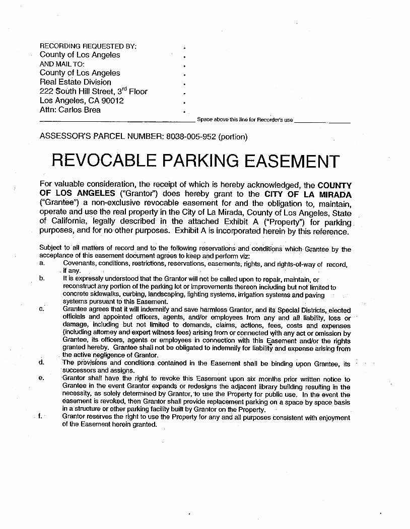
REVOCABLE PARKING EASEMENTFor valuable consideration, the receipt of which is hereby acknowledged, the COUNTYOF LOS ANGELES ("Grantot') does hereby grant to the CITY OF LA MIRADA("Grantee") a non-exclusive revocable easement for and the obligation to, maintain,operate and-use the real propert in the City of La Mirada, County of Los Angeles, Stateof California,' legally described in the attached Exhibit A ("Propert) for parking_purposes, and for no other purposes. Exhibit Ais incorporated herein by this reference.
Subject to. all matters of record and to the following reservations and conditions which. Grantee by theacceptance of this easement document agrees to keep and perform vii: .
a. Covenants, conditions, restrictions, reservations, easements; rights, and rights-of-way of record,-if any.It is expressly understood that the Grantor wil not be called upon to repair, maintain, orreconstruct any portion of the parking lot or improvements thereon including but not limited toconcrete sidewalks, curbing, landscaping, lighting systems, irrigation systems and pavingsystems pursuant to this Easement.Grantee agrees that it wil indemnify and save harmless Grantor, and its Special Districts, electedofficials and appointed offcers, agents, and/or employees from any and all liabilty, loss ordamage, including but not limited to demands, claims, actions, fees, costs and expenses(including attomey and expert witness fees) arising from or connected with any act or omission byGrantee, its officers, agents or employees in connection with this Easement and/or the rightsgranted hereby. Grantee shall not be obligated to indemnif for liabilit and expense arising from. the active negligence of Grantor. .The provisíons and conditions contained in the Easement shall be binding' upon Grantee, itssuccessors and assigns.Grantor shall have the right to revoke this Easement upon six months prior wñtten notice toGrantee in the event Grantor expands or redesigns the adjacent library building resulting in thenecessity, as solely determined by Grantor, 'to use the Propert for public use. In the event the
easement is revoked, then Grantor shall provide replacement parking on a space by space basisin a structure or other parking facility built by Grantor on the Propert.Grantor reserves the right to use the Property for any and all purposes consistent with enjoymentof the Easement herein granted. .
b.
c.
d.
e.
f.
Purs_uant to Chapter 2.08.162 of the Los Angeles County Code, this Easement hasbeen executed on behalf of Grantor by the Chief Administrative Offcer of the County ofLos Angeles on the day of ,2006.Approved as to FormRaymond G. Fortner, Jr.COUNTY COUNSEL. .
COUNTY OF LOS ANGELESDAVID E. JANSSENChief Administrative Officer
Deputy
On ,2006 Before me, CONNY B. McCORMACK,Registrar-Recorder/County Clerk of the County of Los Angeles, in and for said County,personally appeared David E. Janssen proved to me on the basis of satisfactoryevidence to be the Chi.ef Administrative Officer of the County of Los Angeles, and
acknowledgedtÒ me that such County of Los Angeles executed the same.
IN WITNESS WHEREOF, I have hereunto set my hand and affixed the seal theday and year in this Certification first above written.
CONNY B.McCORMACKRegistrar-Recorder/County Clerk of the 'County öfLösAngeles
EXHIBIT FEXISTING EASEMENTS PARCELS 2 AND3
.
D1r""-:r -;:~ .,\,r'114'l: i ~i." .';i'.1 ,.-..It.t.. ~~ ___...._ JAN 13 20LRECORDING REQUESTED BYAN MAIL TO:COUNTY OF LOS ANGELESDEPARTMENT OF PUBLIC WORKSP.O.-Box 1460
Alhmbra CA 91802-1460
Attention: . Mapping & Property .Management DivisionTitle & Escrow SectionMarn J. Young
c . . ntRecorded I
Has no1been compared lYh ciiginal. .
Oriinal wiD.be retrnd whenprocessing has been complete¡t
LOS ANGElES COUNTY REGISTRA . RECORDER
Space Above This liiie Resen'edfor Recarrer's Use.
Tl DOCEN IS EX FROM DOL'MEi"IARYTRFE TAX PURS~ANT TO SEcnON i 1922 OF llEREVEUE & TAXTION CODE
nos DOUMEN IS EX FROM. RECORDING FEPURSIIANTOSEC0N 27383 OFTBGOVECODE
~
.,EASEMENT DlmD. .-.
For a valuable- consderaon. receipt of which is hereby acknowledged,(he COUNTY OF LOS ~GELES, a body cOrPor!lte and politic, hereinafter retèrred to as the "County, doe herby .
grt to the CITY OF LA MIRDA. a municipal corpration. hereinafter referred to as the "City", ~ eaement foringis and egr purposes in on. over .ad acrss ;i thatrenl proPrt in the City La Mirada, County of Lo
Angeles, State ofCnlomia, descrbed as Parel I in Exhibit '.'A" attached hereto and by this reference mae a paheref. . ....Together with eaements for, an the right to !=onstrct. maitan, improve. opeate and use parkig lot and.
. '-.iiportenan Sl1cwrein mrove-aeross. an thsnenl.propeny in- saDCìty ;Cöuhty aiëlStãtë, .ëlescröé äš Yåils.2. 3 and 4, respectively, in Exhbits "B";"C" and "D'; attached hereto and 'by th reference made a pa heref.
Together with the right to enter upon and to pas and repas over and along said çaemen~ and. to deposit tools,implements and other materials thereon by sad City, its offcers, agents an employees, and by any contttor, its
agents and-employee engaged ,?y.said City. whenever and wherever necesar for the pures abovè set for.
An of me abve ~ments ar ma~. in accordce wim, and subject to, th.! certn Pro~ .Ac~itioñAgrment. by and beeen the.County aid the dry, dad Novëmbe 17,1999. rerded Novcmbe30. 199. as.Offcial Recrd D~ument No. 99- 2204, in the offce ófthc'Recorder of.aid County. said. teß be~g by:Is ..reernce made a par herf. . -. .
Pursuat t~ Chapter 2.1 8 of the Los Angeles ~ounty Code. lls conveyane has been executed ~n ~~ said
County .. the Dlror of the Depaent of Pu~lic Works of the County of Lo Angeles on the . - .. .
. day or cPr~ ,1999.
COUN OF LOS ANGELESa boy corprate ard politic
LA MIA CMC CEER EASEMENTS.Eaement Parce. 1, 2, 3 aDd 4(F"de: LA MIDA PARK (2)Portons or Parcel 7 A)
. I.M. 34-C4S.D. 4 M992893
HARRY W. STONEDirector of Public Works
"":1rada-rev. wp
By ~ ~C~W'Assistat Deputy Diretor
NOTE: Acknowledgment form on revers side.
.~ l'!
.'~"çKt'f.nWLE;oGMENT FORM...,,' .~t..tFf)Di€OUNY USE ONLY)
i. 'l. -..)" .' . .).. ,55.. . "" -. .
). . - . .-
STATE OF CALifORNA
C;OUNTY- OF LOS ANELS . " .. On ~~..: :~~q~. ". - .... -~ '~Çërote . me. CONN B. McCORMACK Regiir~Reeord~rl
Cl:RTlFCA1' n, ACêÊí¡A1CÉ- 11s is .~o cert tht th interest in real property ~nveye'by th with deed or'grt to:tÍ" City ofL Mi
a rnl.'Orpration.is heby accept~d uner th authnty. of Reslutin No. 60-0 _ .." _ -.._ -. . --. .of. tIiCity-CounilofSaidCitýaipîeØou June 1.4. 196"0 . . . .antheGrateconsts"totbrerdtionof said deed. or grtby its dUly auÛl1Ì offcer.
Dated December 6, 1999B~/~Gary K. Sl.n, CitY.Ma a:~er
, I
CALIFORNIA
ALL-PURPOSE
-.ACKNOWLED.GEMENT
STATE OF CALIFORNIA )COUNTY OF lOSANGELES )
On De~ember6. 1~99. b~fote me, MARILYN.L. WAGNER. NOTARY. PUBLIC,
personéiiy appSared,.GARYK. SLOAN, CITY MANAGER, personal/y lmown .to me to- be the person Whose name is subscrbed to the within instrment and.ackowlådged tome that he executed the same in his autorized capacity, and that .by his Signatue onthe instrument the per.son or the entity upon behalf of whièh the person acted executedthe instrment . . . -
' '.' LOS ANGe. c;TV .'. . - Comm. Ex. Ap 13.2001 ..
'~ì1 ~dA#' OPTIONAL INFORMATION- ,t1 ~#At1'
DOCUMENT: -Easement D.eed Parking Lot - Ciyic Center Projec - Acptace by.Cit
.:DATE OF DOCUMENT: December 2; 1999 -' NO. PAGES §
. SIGNER OTHER-THAN NAMED ABOVE: Briån Scalen. Assistant Deputy Dii"or
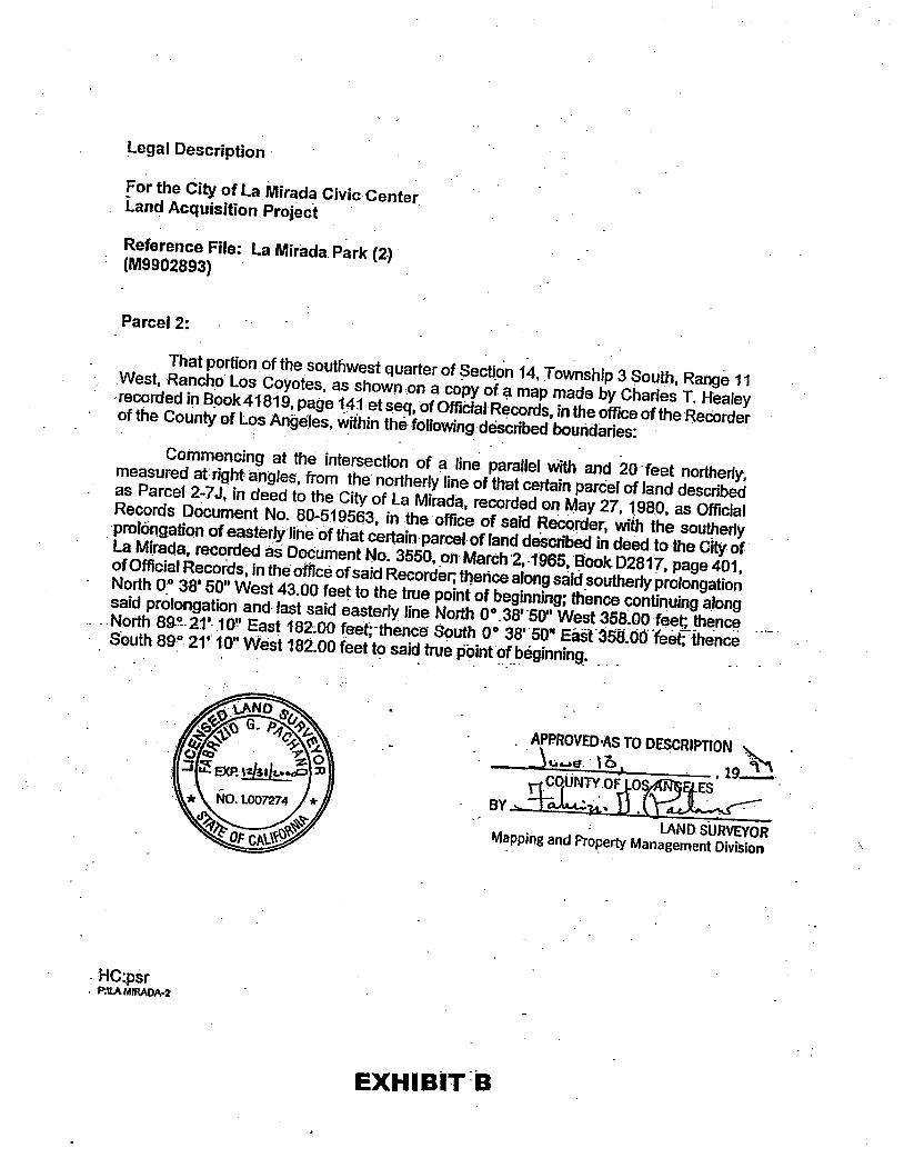
Legal Description
- For the City of La Mirada Civic Center
Land Acquisition Project -
Reference File:- La Mirada Park (2)(M9902893) -Parcel 1 :
That-portion of the southwestquarter'ofSection 14, T~wnship.3 South, Range 11,West, Rancho Los Coyotes, as shown on a-copy of a map. made by Charles T. Healeyrecorded in Book 41819, page
141 etseq, OfOffciarRecorcS~ intheoffce of
the Recorderof the County of Los' Angeløs within. a'smpoHand20 feet wide, the southerly fine of whichis the norterly line of that certain parGaI of land described
as Parcel 2-7 J; in. deed to theCity of La Mirada, recorded on May
27,'-1980, as Offcial Records DocumentNo. 80-519563, in the .offce of said Recorder.; _ '- . The norterly lin~ of
above described 20 foot strp of Jånd ,snaJl be prolonged. or .
shorteriedat theeåstêrJand we~terlyterminusthereof so as
to terminate in the norterlprôlongationof theeastérly.and westerl lines
'iAND SURVEYORMappin~ and Propert Man~ge~ent Divsion
1
HC:psrP:1l MIRADA-t
EXHIBIT A rJUN 10 1SS9
Legal Description'
For the City of La. Mirada Civic' CenterLanc. Acquisition Project
Reference File: La Mirada Park (2) .(M9902893)
Parcel 2: -
That portion of the southwest quarter of Secqon 14, Township 3 South, Range 11. West, RanchO Los Coyotes, as shown
on a copy of ~ map made by Charles T. Healeyrecorded in B_ook41819, page 14jetseq,ofOffciaIR~Cords, in the offce of
the Heeorderof the County of . Los Aneles, within the following. dêscribed boundaries:
Commencing at the intersection of ~ line parallel with and 20 - feet norterly,measured at right angles, from the- northerly fine of that certain parcel of land descrbedas Parcel 2-7 J; in deed to the City of La Mirada, recorded on May 27, 1980, as OffcialRecords Dòcument No. 80-519563, in the offce of said Reoorder, wit the southerlyprolöngation of easterly line
of that ceFtinparcl of land deScrbed in deed lothe City ofLa Mlra~a,recordecâs D~ufTentNo.3550, .oil March~, .1965,
Elook 02817, page 401,of Offcial Records, in the offce of said Recorder; tlence along said .southerly prolongation
North 0:° 38' 50" West 43.00 feet to the true point of beginning; thence oontinuing a.longsaid prolongation and. last said easterly line Nort 00.38'.50" West 3SS.00feet; th~n~
.. ..North 8g.~.21'..10!' East 182-~OOfeet;-thEmce South 0038'.50" Eál-35S.ÓO"feet;-:fhence. . S.outh 89: 21'.1.0" Wesl18~.00 feet t~ sai~ true p~int~~.~ëginnin9'
. APPROVED.? TO D~CRlPTON ~ .
~ \:LAl=. , 0 , , 19~_
BY~r:~~ ..; LAND SURVEOR
Mapping and Propert Management Division
- HC:psr. . 'P:\l M/RADA-2
EXHIBIT-Ø
Legal Des'cription _
For.the City of La Mirada Civic CenterLand Acquisition Project .
Reference Rle: La Mirada Park (2)(M9902893)
'Parcel 3:
, That porton of the southwest quarterof"aection 1~, Township 3 South, Range 11West,- R~ncho Los Coyotes, fjS shown on a, copy ,of a-map made. by Charles T. Realey
. recorded in Book41819,page 141etseq;ofOffóial Records, in
the offce of the' Rècorderof the County of Los Ahgeles, within the fOlloWing described boundaries:. . .
Beglnn.lng. at the interseqtion:of aline.paraUelwith and 20 feetnorterly,- measuredat right anglès,Jrom the northerly line
ofthat certa in parcel ofland described as Parcl 2-7 J, in deed to'the City of La-Mirada; recorded 6n May 27,
1980, as Ofcial RecordsDocument .No. ,80-519563, ,in ,tlie :offce of
said Recorder,'wi thesouterfy prolongation- of the ef!støôy line of that certain Parcof land describedin ejeøøto the CIty of La Mirada,recordedas Ooctiment No. :3590; 'QnMarch:2,1"965¡Soçk 02817, page
00 38' 50~:West 43.QO ftUlt; thence.Nort-89°2t'1 0" East 182~OO feet; thenCè So~ltlr22012' 27"Eåsf187.6Â f~t to.the beginningofätàrigènt curve COnCave to the west
and .h~vin9- ara(jius:.of.240 fêElt;~thenee- souerlyalornSaid-CUMJØ9:5f"éëTff~asterl ,__.- , prolongation ()fth~rçC;)lirS.eha~ing'!abearingof'Soufh,89~ 25'
56"Westin the.nòrtherl .boundaryQftlatCértiifl' pa~1 of lal1ø'desërib~in deeto CltyòfLl Miradsreôrde(fon. September9,~ 996..aS Ofcìa!Riacprds' Døcumel1t~o. 96-1481 ~8, in the ofce!ofsaid
HeCÔrder;thencêYlterf, "~¡¡Qn.g 'lastsàid:èáSfèrl '.. prolongation arid said norterl. boundary 179J:J5ìeet to thë eásterly line of that certain parc of land descrbed in deeto Olfve lawn Memorial Park. Inc., rerded as Document No. 3312, on Mårc 4, 1966,inBook D3227, page 222, of said Ofcial Records; thence N 00 28' 30" Wtltafpl1gfa~t saideasterly line and its norterly prolongation 333.71 feet to said paralelline;.thenee Wè$tt!rlalong s'aj¿lparair~llin~'to the
point of beginning. -. .,Exc:ptng therefrom thatporton thereof
Which Ifes wiin thtcei1fn parcel of landdèscribed ind~toOlivela'MemoriaIPark, Inc.. rècorded on DeCmber 16,1987, asOffcialRec~s.D.oi~l:hient No. a7~199100Q, in the offce of
said Recorder.
APPROVED AS TO DESCRIPTION
~vui: '1 b J , 19~ .HC:psr BY. tfO~Ni:.,~~ nS. ~~P:UA '"MOM ~-+ _ _lAND SURVEYOR
Mapping and Propert Management Division
EXHIBIT C 'JUi4 ! 0 B~
Lega' .Description
For the City of La Mirada Civic. Centerl-nd Acquisition Project
Reference File: La Mirada Park C?)(M9902893) .Parcel 4:
. That portion of the.southwest quarter nf Sèction14, Township 3 South, Range 1 f _
West, Rancho Los Coyotes, as shoWfl on a copy of a map. ~ade by Charles T. Heafeyrecorded in Book 41 819, page 141 et seq. of OfclalRecords, in the offce ofthe Recorderof the County of Los Angeles, within théf()flOWng.d~scrbedbOUrìdaries: ".
Commencing at the intersecion of a. fine paranel with and 20 .fëet.. nonherly. . ..measured at. right angles, from the n"brterlyline of
that certain parcel of fand desQnbadas Parcel 2-7J,.in deed to the.City of laMirada,:recorded onMây 27.1980. as Offcial..Records Oòcument. No. 80-5"19563. .inthe offce.of said Recorder.. wJth the ... norterly.
. prolongation of the westerly line. of saidcei1ain parclof land;
thence North. 89 ~331.SQ". East .127.92feel along saidparallel/ine. to .thetre
poinf of . beginning; .thence .Nort 0°26'30" West 270.00 fe~t lo'lheriorterlyfine of thatcertin.pareÎofland ... desribed in deedto:CountyofLosAng~les. record~ asDocumentNo. 2845.,ori.Junfi:19,
. '1968, in Book D4038..page987;Ofs~idOffciaIReCOrds:theoce alonglast!)aidnodh~rf
.. _. . .iin.Noåh .89 ° 331.3ti.'East-168~~~t.to-east~rfline"Qtthat~rt~'n:jircel()fíanã _~. .describeqin deed to th~ CitY of Lalviiad~.record.~das Docment No. 3550, .an Matc
2;1.965. Book. 02817, page 401, 'of OffciaJ ~EltOrds;. intheoffÇë of said. ReëQi"ør.' thence .southerly along last .said easterfline~Í'!d its s,OLlht:rlprolongatioh :270~QOJeeUos.åidparallel line:. thence westerl along said paral'EllUne169;26feet.to the "lrle .pointofbeginning. . . .
'VER MAS GUANTITIES ARE 5HJi ON PLANS.ITHTHE ÁD.JACEN'r 5H AND/ORGRQUCOVERiNS. PLANTS SHALL BE INSTALLED ~ITHANT GROUNDCOvERS TO ~ITHIN 12" OF TRE OFING AF! ARE'TO REcEIVE IsROUNDCOVER
160 AREAS NORMALY FOR me Y'K5 TO"( GONTAçT l-ERICIDE (MONSANTO "ROUN-UP",Y'EDS ONLY PER MANUACTUR'S:AT PROCESS IF ¥'S PERSIST.
~RS SHALL BE INSTAL AT ALL TRES
EXHIBIT HLAND WATER CONSERVATION FUND DOCUMENT
Slle 01 Call1ornl. - The Rncrc AgDEPAR'~!)F PARKS AND RECl:nON
LAND AND WATER CONSERVATION FUNDPROJECT AGREEMENT PROVISIONS
L Dennltlon8
A. lb. te "NP~ 81 us herin meaiilh NaØo Par Seic, Unit Slam Døpart9l of the Inl8r1r.
B. Th te "Sla 81 ul8 h8l8ln maana Th Sø 01 Ui lni, or øn I8prelal-1u defeal8 Ih ii 10 acfor iuc SKia.
C. 1h 1l"D as ushelr mean ib DbvollJe Nati Park Søiv, orall reresenlave IiDy deagl8 tI øuiliyto lllonii Dire.
D. Th 18"lls Omc .. UH h8 meø tti Caloa Dnici of Pars an Røllon, or oltr Stli ollr 81 deiignby di Go. .
E. lb. te "M as UI liie me Il La an Weter Coon Fu Grats MaF. Th Il.Prjiu UIlilnme di pIjiorpisøiiwhi. tt suBCof it iiiil asdelledlntt Pr)eçtG. lh teim "P Prii.. ii he lIlt fo and II supplental atll us to dllcre an eslmal il cot
ofJl. ii ordølopr)ø lídwi th U8so Ollln auof an epplÎ /o ie ßnciiiiiisliinc.
H. Th te "Sle... iiedhør me lh SIi o' CaIo iior It off nl,lh Dep."'of Park.ne AeallL 1h tl "Part" 81 us lKn means tt repien of th fedra fund to be dlst in aC wi tt I8 oIlhIl .J. 1l18 "Stale fun-.. lIedhtreme Ihemoya mad
avilble by ih Sl Dr a Paciant.s malng mone fo pr)iun 1I La an Wal Ccseal Fun Ac: 01196, 78 St 897 (196).
It The /e "las l. or"L-1i us herein mens la ia fr tle Fed Goerment
D. COInuIng Assurincs
Tb paes 10 the projec agrelHnt epeclßcIl racnlzed tht the Land and Water Conseration Fund assstance.
Pro crat.e anoblJatJori to iilniain th property descd In the projec agreement cosistent with the Land andWat.r CoHIalJo Fud Act and the ronowlng requirements
Fwr.1l1s .cknowledged Intent of Ihe partl.s her.to thtrelpJents of assisan will us money. granted hereunerfotlepuraofthla p..m;lI1l.t ....lance gl8nled fr the FundWR result Ina n.tln.... consurate.. .. wih the Sltn:oalh8 In a palclpnla outd reeatin. It Is Innded by bot pørtlas hertD thet....1: fr the Fu will be8ded1ò rathr thn ",place or be subatlted for. Stte and Ioloutdoorieitlonfuds.
A. ii-l.1I .. ni of lh usl Ih il wi.. th io splc reents -id 1h te. of ii pv--8. ...IQ....di lI cIln .. fl)i aiinl8mio. en ib dati ~ mi ma i- 01 lh
'....... llii. 8a or cl wllb i- ii Wai .ÇIFi øn Il " Ì1111O su 8lbN ar
=~-i"=_~:=::~ll=-~~aø::-==rli=~"_..hInlh e8 ollipW. 1ISetø Ihál appi succ: cn Ifli Inltto wlii lCWlihlh.it", øxliiccis Il ll I'lIpla 8Idon upo su coii as he des I1I1 to as th sublilU of .oil8 JIM of8l1e eqalflr miit va and or reonabli eqivt uselu an Ioll 1ls recentla belJ SU CD Se'6( (3) Jlii. 1b ap 01 CDvølo shall be at ti IO disQ'11 of lh Seta, el IicI:Prii th Cl..oflh piic Ile pi th Uii Ofce, an ih Dir may muY8lle.. diIn 1h piegllnllrldlh dad prlCbcmép 10 prvl ~ mo sallsl pubc oUl nitfon un ex Ihec f)Ul. 8I Se 8(1 (3 pr as Fu nimbl't. pn
In .. ewi ih llPa Se pn Li an Waie Coiv Fund IIti fo 1h ac an dølo. of ~nyll to nm Ii wi fu kr of.. nr InI8 co"M of sapr lDot..pu ouni ... as 8 rer; of iuc nM lrlest be exll lupprov In re of il apdiplll eglOlilI thSll8 0I1h cors _lO.. posi an to I1k ap 01 rønlpoln 8Cwi.ltcoa sa fo in it pr TI pipa fir ag to elf iuc iewi. re pe ofli, rilelD lIStte, aJilh coio of pr tB pI. Th prisio oftt pigr aralaple to: itJI ac iiide knn anlllOby II Sl; wpn iub to oIrou ri ii In.Ih ßl18 In . coWl when kn an agd 10 bt it Slli.
DPR 89 (Re. 1DJ 2
c. 11piagSllltf8 bellllDbedøby itSl fr IbIuClmpbyÖlputMh tfl8ßJofitsagfa Ihp&n. pl' II il rilncr In lIeau or pu ou reat fBci an niWJitlill avableIDtfpeDftfeSlaanDf th UniedStIl an IU beelieiloanlmeøllli anui-itfamofmo hmed by lJ siby wr or 8$st un ii li. of if ~l. ni pa.¡ !h ~ by ih~..th~tD"f.".~lI..ltotl=~...~~.-inifll~".g~lrAii'vi--._1f~fi~""coll! it S1ie fI-ilib) it pttOilh1a 1l1'l. 1l pø M1 8D...1h8J r-'1n1h8VDi oI'a bnby tia piPM of Il Jghhsl be il Ip pirmlC of th agn
D. 1hpiclàgSio cowilipoiCssmprl8fo1nIhNaiiii Par 1Ønn Gimeii. Pinsof sli mll8l1n InID an mad. a pa of Ih,prje &g
E. Th pøagilhlh prperl an facladø In tt pr8glahai be opl8.andmainlaedas praiby man rent
F. 1bl-lIág,ll.. pin1reab beketln ih pa ~pire 8Iavii fopuinle Il 81f II il pi dI In \h ac of It pr.al, -i fi c118 pr)e bc ma mi pi of th
. ag l-lilCi-cidlpewlt Laanwil8Co Fu uswld IIftcatbiCltoolbn puci ni8l.. wit it wr ap ri.it ii Clr.1I Òh. Mcortiiìs.oni-lil8.G. Nó1.11 pdpat .hihDíiwl TIe VI of ite CJ R1gJ Ac.o198 (P olai In acwiih1ï VI oilh Acno pIln ll thll St. ab on II ai of ... ni cc. or nall orgin. be ei~ptrid in.
..b, di ihbe.~. cibe c:subj to db In fi use of 8r pn órfaJlac QÌ l.bj:JXlotfJll-~ Tlpøsh ~ta ar meaiOlto elfi. lhpom. 8I .lilbi 'bi on Il papa or tl poll su or Dler ap puBo ag le wli Funlii- OIl-rlac ordewl Fuanllha be Irsfmt ropuJi~.lipu... .., - .
2. 1lpi~ sli:piWi Ti. Vl of ii CI Alii Acor 198 (42 U.s.c. 2Cprbili er~nlêllCtinwt.,(1) ii pima pu.oIagrtla 10 pieenior(2)dlCiyeR1pinl PnWLII reln uniiiitilll Of pe wh an or sl be beli fr th gnd acwty;. ...
3.-nPlpe shco~-i..iølaan guili. prlgaipu 10 ih Civil RltUci 01196 by the
~1IOfthJn aw Il~ PaSe. . .. . . .. ...~ Th pisina of th lit thl1 parahs appl to any pa of thniai syte wilhnWh ii 8I18 fa or pI,ll' ; , .5. il~sJÌ1lImlagliipeontl baofl8a1. eiito ih88xttitatr&SO,naJedices
./naclnloii OIoitlidll8 ma beni1D1n on the biol røldnc as seHoi'in lle maal .. .UL PrJ.ct~*aunl1cH
A. Appl Fera ClrJi1l$iaIl._;wM~íi'I8Jetl~ giin'li /IlnIlIs~.a Qi=Pa 12.1-12.~~øn CO:PilÏfoAS&l Pr'() ot,~~laBu..~IiNo M02¡~~In"" -lro~ toSlti elkiQDvIIIJ;;l7(ei"fÌpI.;~$ll.1l lo~)o"Ao128(á OfSlårli goli..ll.. ihre to Illiçplill UI or Fe ail:ilr. -l prec . ..
.9. PrPi. "" -,. .1~ ...'Ö~~fo"""'lali-lllS8pi~àStI~t.an"~~lIby.1f..II.pi.Ofil~ .... .., '. .. . . .". d,' " _ " _'._ __' :.2. ll ~tpoll Iegiha.th 10 approile gr an to llance encolrctlle pisef8.. A re
mll 01 .lmac haa be cI ador p8ssedaullli olit prec prpoJncludlalunrsiinpan asau COIu it åi ~ng .~lI it pIl ldniili as it oll ntSlla or itpw to 8C1n c: wi itprpr an to pn IU liWln..ma be re
3. Th palha it 8bilaninto II itri shll rith msts folh prSuntfi wi beaVl io .. eI ii aimall 01 th fa1l.. aiAd Or d81o ~ lh pi .
,Co Pr ExØo1. It,. untoby it PI liit8l" .ill tIllnoolie SlofCaJo flnc folhpoai if
tMln1Jpahlb).dpr.... ......IiC0. . . .ot"'Pro. ..' ii. '. btllLl. Ion.OI.... 1i... .....n... .Iò.ii. ..' 1I. pi..~tiiInÎlI( WI ih lloftt -i An dllher~" no b.......en uritlHwi itfa..~ bt. l1 UiIO Offr th Nati Pi Se.1b it Ibal nDUlpplYln ..Pi Ïl8Riiotth Sl of Cafo
DP 89 3
2. Th Uaso OIcer li pr.. In COlìdiili of th pnll.. mads by 1h paclt li. 10 -it ÇPfe ful fo Ih pu oJ il pr lIuhbburs the lI 10 niiibu th par up 10 60 PØlof Ihullgi)JepnecconOUDex SOpeoflh db prjeCllholn" ag,eillo all röíilnco lobe apie ID We di feia ah of ci .'gle p1je CO. Th -SU Ii 10 be di to ..niøn nifn m Fe Govwiiiiiinuipplele 10 Hi pojettendwI be COpU\ "lbe fi Ilsu ràln ell li. it li it b1l1ng Is iubht II ih Fera Oo. . -
3. 1hpoje pe sh be wi Ih da oIepp of ii pi Ilreor ii ell dale of a wa of 1'"lan lIiiln II ibenoJili1l or8lpipøriuni ii pnls amOrl8mi aoln wi. IM \b pr pelhi en on it dale of co or l8in Fo pi e181an ad Ie . coii JlIJ Pu pewi be onb cf iteprje ./ent 1aDp _'
4. Th pø wi Cl wo on Ib prje 10 be collncewlit al8onae ti all re of rilili th fushal- ap an IIIbI th p1 wi be plOie II çoleii .. rI cfen.
5. Th St wi reii it fa 10 be deig 10 coy with the Arra Bars Ai I), 198 (PuI Ll ii0), andDO SeS0 Reli (0l CFR Psi 17).11 palwm be mpslle for~ iili.
8. Tbparlhal se c: of the wo In ec:eordanc:nith iiprvedeoli\n pla li ipelcll 8I ili.~ caph wlalaplc: le.lti.lol8-initlL .' .
7. In it ev li JlJe co by ti pr iagi-lInl Inc: iu staei of il prJe ci be capÌli Inaø wI II plan II ap fo, th pr tJ pac: shling Ibe pr lD . pot o' 181kUIIl eg up by it pl~,t an. it DI orli clllan"; anil Ua 0I.
lt. 11~wlprban maCQl8an ad årenin ~n -ifn IIIl.ai.lDirfull conipll8woco(o1 wI ".apprY8planl 8f splI,ltilhWru Jlre IU II oi In .. ii ÑPS iiøy l8. . . .
ti. .ll pu1l c:wl ti 1I ollliJ " anTl iii.ih UnIo Re As en RiPrAcPoIAcof 187(P.Ll1-694Sl 189 (1970). ønlh apJc iegulaans anpia lnllAcfad.. pnrlll0l8IdwliapplJe il asi. ttilAc:ha licolJwllhfolllDbeCfpewI..ilunllpiiireL .... . .
10. lb p;pa COw1 \h prBIs 01: &ell Or 11988, ie to evalualÎ o'Øo hll:elIMOt112B~I'l-lDlhpmnior.coin.øn iibalorW8pgluøn EllliOi 11920, reng ID iI~ofwela
11. l1 Plwl COwi \h io ir pun: nilll8nb 01 SeIl102(a) of\h FI DI-iPrAcof 1873 PuLa9M4, 87S1 lI, epve o-bi 31. 1978.Sean102a)nilf ite~ 0I111øIn~niwf aufi ÎI av... can fi lb. ieol8n feli.ìii-ie rocpll-otqil pi..liusln.... ..hubeld..ui..haØSpeBoliblitFllnAdofli Fe EmerncMiIAg. Th pl""in ~ iilnyfl oflogrgv,lnpaen iellie,lUbI. dlle Bulia io ør gi onolfG oIdrbrlir.... ..
12. 1IJlwil..llit fi. unitsowleas. orsuwhlllbeulrnll~QlIi plÒl-ibnlliblù an" Enii Piii Ag~ (EA) ii olVJ! Fl~~AOCFPi1UJh..itwï~1I"lK_ilNPSol it ~01 an CoIiIl DlolbtEPACIolFi. AC,~.li."'~~Uilln htprlCll ~~~Jahln by ihEPA.Tlp.~'toCl_ìi~.~ on orie llputoihClAiAcol1970. nípibl--lò liihè: rnlUn1C:ouubconnc In.ie ol$100oo. . .
13. .1hp.~itwl anllSl-i NPS In.ii c:wllbSe 108 0' ll NaIi PrAchf116eí-i(1iU's471i0r115N. iiitAranHiIO~ol1eø(18u.;C..1.l-l1ill).~,.ll~.HtIDIlPiS8tlQf ~o,lhi:d_~,.~"_ld.,..-. .pñiWllli~iilolrln ih Nàli RiIsl8øfHltòP\Ih..lUliïctoel(seCF Pi80.8)by ih ac.ax~ ih figr øgri of lhexlste of." ii pii, an by (b)copllng with ill'~.1I _bi by \h fi gi1D ag II avo or millli\ead eirup II prpe. .,
.14.. ~.wicoPiwlih Ex Or 124"MIyBu...EnIrp Deop.. fò:a. . PÌ ii Ii fI on bltS liii ..
.b. SoIi.Ir..1I.. po so 01 eueqlp colr or....~ WI f8 d-ll ieenlnto IIne an _lde lI IbwI-i pl by..1rd.Fo.. prln$5,OD or mo In gi8u11\ (Ilt fopÏlIlr ~ci) Ibl-lh-ipd lD Ih CO of CO anfIf' IiIC ,.cp it¡ un pr c:pl..I' dè \h ëll 10 hi rily bu IrL 11 18po SF 33 wI liil ~lIroIhl1 ole8cllqu (lit.. Jaar 31. AJl30,.i 31. an 0r 31) 10 it Na~ Se RiOIin Sa Ri.
DPR 89 ..
D. . Colnn Connc ki by !h Papø SI Møill Foil Reen:
,. .Cc foco In 8i' of $10.00 sl be Bw ii a Jl1 of c: ti!l IIM folI;wI-liipUiddeli, l8a1 ii, anpublOp Coot al ødse bi an a coyor ih C: sl be tè fa Inby it Di an ih St.
2. 1Jpa lbin aD bi on cotm focoli diflfw ar begUl 10 8S1 inCOIn
a ",'" ~ oi sl be Iuue fe Ìi ne ct In th fi be i: Ilde COirol$10,OOorma. Sù ~or iha be ma a pa of th pn ii an sb be ke aväle or 8I
4. CoIl fl co iilir a provisi ~ coßøn wi ii Cod -AnIJIC. Ac (18 U.sC. 87.l)asIU by De of Labo relatins (29 CFR ParS).
5. 1b paiwi c: wi oit prllst ofOMB cmiar M02 Allnl o.e. fo pivlo niIo.c;ic wi o. ElAc.røenls (una. ni by a pri- pn IUPøm.nt~). SlIUIi fu be pr whld (e cowi DtIBaAc rent ai c: to.."'lhgranUil8ln.lIlofS2,OOIlIn.PIfocowlit IUAc(40 U.sC.27a'10.7) 8f.. iupemll by Oøl of La reii (2 CFR Pi 5)
8. 11~tshiilnt8.orca"lobelnlnaR ccslco eiIlS10.0ò (libÖUil Ia po . ' ..... . . .~it pi oftlico it cotragi 81 fo:
i I) 1bCl nollli-en emploorapplfoømbe ólmc. r8 cO, seor Il ci. Th conln wila ai aè to .. li l!Pplts 81 empl
an .ilem.. ar tral du emoyt;wi ivto itL-ac; Cicocr nd ori SUacn' iMlIn bu no be lill to. li ra:Emt; up demo Cltr 18n1 01ivad; laorlell;.. of pa oroifDofcolnli;anHl fO inIncM ii1l. 1l c:r as ID poll. In coua ii.. 8V8I ii .mpla~ nap fo emplt, nollilobe pi byit cang of'íefo it p~Íliärililnccllell da.. . .... " .. ..' . '.. . ,. '. '.. ., - ~,' - .
12' Thcclrwl,In.. soiclioriidvfoemlo plii by OIon behøolli.CO~.~1a18ih ai qu apli wI nive c:on fo empJonlwilh re to ra. rilci, Coor. seX. 01na or
"( The cowi se 10 ea Ia un 01 niaenlve orWOrs wi wfch hI) ha a coløci lialgagiioroicollCl unla anob,lI bt~by ~uaglK~!l~,ldit IIIl o.WC' reenlali ofli eclrà rxïn~Il~~~iI Orii .No. 1124 as ai (3FR 169 (197"). an sh po co 01 no in èOjis jl av ID-i -i apii fDemloymen
"(4) 'Jccwilc:riwiaH pn1o 01 ExecIiWl Or No. 11241i .llIlK.llite nies relail.-inicioritSeol'Llibo. . ..... . ... . ..' .... ..(5 1b~ bnalli 8Int Nqby Ei~N~,". li.1i ei by
.cclÌrn"dediillfD~~nl . . . lnIíJèw.y'~sauÎxIn ~ve Orr No. 11246, as amde an su olh-i ma be~poR,l! reiiYO upn In Ex Orr No. 11246 lI amii, orb) nis, ni Or0ìrs Of tlSe of La,01'' oller.. prby l-.
.(1 1lcclr wI lnll pnol ~ (1)lI (1 In ~ ll~ or puid Olunl 8X by rU reli Cl ml oIll Sel- of I.ISS pullD Se 20 01Eø.Or 11m. aurnendio th.suc pnll ~~li,b1ncll~lNbctrcif'enti.Th oo,i~ wIli-ldí WI reli8ilUbcnlor pu ci li tl~ iien,lJdI..inofen IUpr lr l8lfwnomp~lI~,tIIn ite Mn it co biln rr orJallwl, il wh a WbIr orve u.. ntvlollU cI by li ccnc 8~,lIcoin re th UnSl ii ti InIUIidD to pr th InIlIl 01 th UnIi SI ... . ....
DPR 89 5
7. 1b pat8l1 (1)l:lywi th ab prviiialnçoçjwocaoUl by Itsel (2)8sshit8ld tol8açwi !h Sela of it in anll Sel8 of La,&! ob ib cOmpli of conln wid lub wIit &bw copn andwh it rule.. reii anni-ioi oIlheSøcrtaof Lar, (3 oblaarfulsto lbe Sø oJ ii in an to ib Seii 01 La il Inmnn _ii may rDlrfo ii lup 01 succ, (4) en il ob\l of cilran IU WI iu PI$S iules. re, an or. (5)ca ou iinci an peIÌ1 fo Wial or su obgalm up i:n Jnie up coir anIdtr br !he StIB or it Seia of labo, orih~orihe Inl8pu 10 Pa II. SUbpD, Of ExOtNo. 11246.8Iaman(6)rønfoen InlOancolracolidødfrgov-itconc .ur Par II, Subp D, of Ex Or No. 1124 iiam.ln ed \he patàgillt if it Jab orre10 coly Witbse un1l NPS mø ti an or ai ofth follii 8dniCh, llte, orsupelnWborpalhori:I'h11r eilt anlwUlllllblJappliilh pnruwilhl'lJÌlOwt ÍÌfaor,... oc unli ..fa all Dr ru coenli be nlè:mièH.om SU apta an..fa ilcae10 lbe døt of.1 ra iirJall Ie prig.
E. eo.Je of InI8I1
1. NooJloriipqll oJ Ilpapa Sii.., orFe.. Oovi ii 8Uil In li. oI caloneDlI,mii,
-iL or ap M ia i- h su di ni a c:tn 0I1W1r In co8C wi \his pn8C ah8l haII IJ or o\her persll In..t 1n.8f IU co or 1U. . .'
2. No pe pi serv folh paln co wI~poj8sl ha anna oro\her pø Inlestoith hi emornillby1h pat, In an COnct"onubtrllico8Goi wi \hs prNooJC!empl oflUc: pe re lrlh.pr shal ha-lfiM 0I peiiln181nanl8piIi fo it piec un iuilnt II op ëlsd up II pu1i rerd 01 th jlcft, andSU oll,en M pø bá no paal8 In ii acliii fa M CI bIlof ib padpat. .
a. Nomembof Of deleg to Con ii tillllto 8I1li iii-olitagn orloan bënell 10 -lis henpc.. IU beef alii be In il bm 01_ lGI.... ni.w1it. co lo IIgter beli
.i.' 'Th pepa St! ii it DIr sld be i-lÌ ro 8Iro lh ab coll oIlnlinit prvisi.F. H8Ac
lIpítwlceplwl\hth pnanoflb8 HaAchi pr dino oforemplofdipàrtdpatw pr .aínen Jain cone wi øn Kl1y wldi II iiiii wfe or In pa purst to ibis &gmet sh ta pi In cr 01Ih pd øe pr In II Hat P~~ Acit Ac 5 U-S.C. Se 118k (1984). wi th excil lhør enuiv
G.Pn Acn1. Pr c:eJilb1e fo auCl~a11 be determ upon lh bal or ii cr sel rorl In iJ maal en OM9 CI..
M7.
2. Th.~/I ni Iri 1he us oJ di in cor' cuJ/ 8p in iirdan wi M7, 101 \he papal Ih1i-.1o ih, 0ii8en' .H. PrAdInIl
1. Th pa it8lpnll IUbmihuc I8 8ld dDta.. it~orlJci 0l may ra
2. AnnilaNID"paÏn-inI~iÚ;sflidiln . ba. FD l- CCJ' anlill aiø IlFDci ah be al.. sa.. po fo In 12U,S.C.:z
ii, .: PR"e anJi_at il ifWlFt'.s11l slblavÌtro kiSPicbylh Slll or th NPS li~1nl8is û!l lJíiOl Or lI Dh iirø. ' '; .
:L Au Re an CU Re fcRec1. Fi ni, 'IUng ci, st re ii ai olh ri pl to \hlagrt sll be .181a lor a
peofth JtIn iiwl ilCF Pa 12.1-1292;øc di ni iha biueta be tt ~iipe. ai lIngs ii no be raii .
2. Th ..1I pe l- to .. ci.. cf ii fial 4t Ñpfo.. PJ. or.lt col8 poj8 e111a. sa an i- Ql.. au ID ~ mJcopfln l!of or re4. Th UiilO 0I, Sell 01 it Jnci, -i ih Coer ~ol 1h Unit SlG or -iol di du IU
I'I8 ah htac io-i bokl do.. pe iii-ol tlpidpø~ lh MJ whidan pei1 to a ap pn fo th.pu 01 mi au 8xi, exces an tn:spts5.1JpøcJtwiii cowl \h pilo ciOM Cinli A-(es pivi un \he Sigl AudtAc of 198)esl8lstin
aut rib Fo stem an io gowmnlS tlt reve fe assillce
DP 89 8
J. Projø Term , ;-
1. Tl Ua Of or lh Dir mø tlmpora 8usnd SIM I1Ia unil proje pens mrct acn by ihplldp or pe a di ID I8In th grt by li NPS or Ile-St.
2. Th papa ma un tlnatl ii prje or coldal8 pr element Bl8l ti J:ID it. fi paii cilhpr8C or coie pro8C8lemeL Al th InIl paent, !he pr ma be tømiln. mofied or amde by Ihpa on by mutal agr
3. Thell OIordi D1nimay tenat/ Pllelnwhole. orin part atlltime beJot/daofcx. whBnIt Is dBl8rm lt Ih grnl8 ha faile II copr, wI lh conciiof it gnL Th Uasci 0f or Dhwil pnnofy dt partln wr6n oflh. d8iiønan ih re rorit lali.lolh wllh it øIve da Psønma ID thø pipant orl'ØI by th St im Prois I8Ìliiei fo caus sIii be in acwllh itele ri anIi of 1I paøs.
4. Th DI.SIa or paåp meløgrln wl. Or in paiet lI ti befo th dell ofQ)ii wllllhpanagellth ai*ionofll. prJewolc ritprce bøci reul c:løwllh ll fu.iipe0' fu. Th IW pi sh .. up lh. ll co. Ing. it. ei cl n. In ii ca of pa81I8Jn.1I po tD be 1l18.l1 pishdno lnrioban fotI l8llponefeIdel8. an ahC8aa m&OUt8 ob. poTh NPSma iifu cn& ID lh. pat foit Fed,ha of flit no ob. prpøif In by ii. grnt pr to Ien.
.s. TemidelerfocaOr foc0Ílønnithit prin qibe brughl tD 8 idofi-usfuuagr up by ih par.1h Uin Ofr, iU it DIr, or th 88 fi pr by li Na1 Par Seiv beretu
,. It Fu Ac&Th pir1dpi wi pøil dsp In . co pl 8 si whic øclcøs La an Wat Co88 Fuaalll. T1slwibeprbyllSl Dertof Pa an Røon anditintali by di papewibelØl8upn PlJechlevepmenl or i-n of ii pr. .
L Hold Harml8
. Tbpa IllithSlof~llanlis~ag8lii anemyiagai&ønholdiJlafrluhills.fr øn anall ci de da roes, cots; an eic8S ofllil cl to or arin oi&ol. eith In whJe orin pawtll dnll or fn, lhorg deloiir. cOnSlnli opraii. or maienice of lI pn8C .
DPR 89 7
SQte of c.r.iornã - The Resurc AiiOlDEPARTME OF PARKS AND RECREATION
LAND AND WATER CONSEaVATION FUND PROGRAAPPLICATION
This Form and Require Attchments Mus Be Submitt for Each Project SiteTYPE OF PROJECT (check on~ belowl
Construct two picnic shelters thatDisabilties (ADA) . standards. Replacesigns that comply with' ADA standards.
comply with Americans withsignage-- at parking lots with
..
F~, 0.. prJe Uncl Tenre -PrI ii 1 OS .56 -i. 1 05 .5fi _Äcr owed ln f.. ilme by co ApIaFor Acuh JIie Pr br will bl
Acuhtd ",' '..lImp'a by Glll J\ca,,!
"""
A~ru _laba und . ,. i- Acuired In oiler ih fe :imp, (~JtP/'¡'".
Ac oihe, lllat l-Jl/.;n/
I canily tlitha infor.don çaulne In "'Is PiolC ~lbon fom.lniiri l- -ienti b ecral8 -i that thl. proec Is coi viih 1hP.-k an lei:lÏan eleint of tha aøkabledCYat-l ii"" pi_ at Lh dlukl pak an re101J p~ lInd wil safy . "Is Pririy ne. .
S;sntd d f ..4i-...__a-.'......_ 11- ~-q3Daia
OPR 823 (1/90)
EXHIBIT ISLOPE MAINTENANCE AGREEMENT
RECORDING REQUESTED BY:County of Los AngelesAND MAIL TO:County of Los AngelesReal Estate Division222 South Hil Street, 3rd FloorLos Angeles, CA 90012Attn: Carlos Brea
Space above this line for Recorder's use
ASSESSOR'S PARCEL NUMBER: 8038-005-952 (portion)
SLOPE MAINTENANCE AGREEMENTThe COUNTY OF LOS ANGELES (the "County"), in exchange for consenting to theCITY OF LA MIRADA'S (the "City") request to alter the existing topography of LaMirada Regional Park in connection with the construction of an Aquatic Center, herebyenters into this agreement (the "Agreement") outlining the obligation of the City to
maintain the real propert in the City of La Mirada, County of Los Angeles, State of
California, legally described in the attached Exhibit A (the "Propert") Exhibit A isincorporated herein by this reference.
The parties hereby agree to the following terms and conditions:
a. As of the date this Agreement is executed by the parties, the City shall maintain the Propertyincluding, but not limited to, ongoing maintenance of landscaping, drainage systems, retainingwalls, replacement of landscaping and irrigation systems.City shall be solely responsible for the reconstruction of any slope that fails for any reasonwhatsoever.It is expressly understood that the County wil not be called upon to maintain any portion of theProperty, or reconstruct any portion of the Property or improvements thereon.Grantee shall be responsible to cure any drainage problems and/or resultant damage to realproperty or improvements owned by Grantor and located adjacent to the Property caused as aresult of water run off from any portion of the Propert onto Grantor's-propert including theinstallation of drainage systems and repair of landscaped areas on Grantor's property.City agrees that it wil indemnify and save harmless County, and its Special Districts, electedofficials and appointed offcers, agents, and/or employees from any and all liabilty, loss ordamage, including but not limited to demands, claims, actions, fees, costs and expenses(including attorney and expert witness fees) arising from or related to any act or omission by City,its agents, employees or officers in connection with this Agreement. Grantee shall not beobligated to indemnify Grantor for any liabilty or expense arising from the active negligence ofGrantor.The provisions and conditions contained in this Agreement shall be binding upon City, itssuccessors and assigns.
b.
c.
d.
e.
f.
Pursuant to authority granted to the Chief Administrative Officer by the County of LosAngeles Board of Supervisors on , 2006, this Agreement has beenexecuted on behalf of County by the Chief Administrative Officer of the County of LosAngeles on the day of , 2006.
Approved as to FormRaymond G. Fortner, Jr..COUNTY COUNSEL
COUNTY OF LOS ANGELESDAVID E. JANSSENChief Administrative Officer
Deputy
On , 2006 Before me, CONNY B. McCORMACK,Registrar-Recorder/County Clerk of the County of Los Angeles, in and for said County,personally appeared David E. Janssen proved to me on the basis of satisfactoryevidence to be the Chief Administrative Officer of the County of Los Angeles, and
acknowledged to me that such County of Los Angeles executed the same.
IN WITNESS WHEREOF, i have hereunto set my hand and affixed the seal theday and year in this Certification first above written.
CONNY B. McCORMACKRegistrar-Recorder/County Clerk of theCounty of Los Angeles
ByDeputy
CITY OF LA MIRADA SIGNATURE INFORMATION INSERTED HERE (STILL NEEDTHIS!!)
EXHIBIT JUTILITY EASEMENT
RECORDING REQUESTED BY:County of Los AngelesAND MAIL TO:County of Los AngelesReal Estate Division222 South Hil Street, 3rd FloorLos Angeles, CA 90012Attn: Carlos Brea
Space above this line for Recrder's use
ASSESSOR'S PARCEL NUMBER: 8038-005-952 (portion)
UTILITY EASEMENTFor valuable consideration, the receipt of which is hereby acknowledged, the COUNTYOF LOS ANGELES ("Grantot') does hereby grant to the CITY OF LA MIRADA("Grantee") a non-exclusive easement for and the right to, construct, maintain, operateand use underground utilty lines and appurtenant subsurface structures, and no otherpurposes, in and across the real propert in the City of La Mirada, County of LosAngeles, State of California, legally described in the attached Exhibit A (the "Propert").Exhibit Ais incorporated herein by this reference.
Subject to all matters of record and to the following reservations and conditions which Grantee by theacceptance of this Easement agrees to keep and perform viz:a. Covenants, conditions, restrictions, reservations, easements, rights, and rights-of-way of record,
if any.It is expressly understood that the Grantor wil not be called upon to repair, maintain, orreconstruct any structure or improvement to be erected or constructed pursuant to this Easementand that Grantee, upon completion of the initial installation and any subsequent repair orreplacement of any of the utility lines shall be solely responsible for repairing and restoring the
. existing driveway and/or landscaped areas in a manner satisfactory to Grantor.Grantee agrees that it wil indemnify and save harmless Grantor, and its Special Districts, electedofficials and appointed officers, agents, and/or employees from any and all liabilty, loss ordamage, including but not limited to demands, claims, actions, fees, costs and expenses(including attorney and expert witness fees) arising from or connected with any act or omission byGrantee, ifs agents or employees, arising out of the exercise by Grantee, orits officers, agents oremployees, of any of the rights granted to it by this Easement. .The provisions and conditions contained in the Easement shall be binding upon Grantee, itssuccessors and assigns.Grantee acknowledges that no surface rights are herein created except the right to access thesurface for the initial installation, periodic meter reading and subsequent repair or replacement ofthe utility service installed in the Easement area.Grantor reserves:the right to use the Property for any and all purposes consistent with enjoymentof the Easement herein granted.
b.
c.
d.
e.
f.
Pursuant to Chapter 2.08.162 of the Los Angeles County Code, this Easement hasbeen executed On behalf of Grantor by the Chief Administrative Officer of the County ofLos Angeles on the day of , 2006.
Approved as to FormRaymond G. Fortner, Jr.COUNTY COUNSEL
COUNTY OF LOS ANGELESDAVID E. JANSSENChief Administrative Offcer
Deputy
On ,2006 Before me, CONNYB. McCORMACK,Registrar-Recorder/County Clerk of the County of Los Angeles, in and for said County,personally appeared David E. Janssen proved to me on the basis of satisfactoryevidence to be the Chief Administrative Officer of the County of Los Angeles, and
acknowledged to me that such County of Los Angeles executed the same,
IN WITNESS WHEREOF, i have hereunto set my hand and affixed the seal theday and year in this Certification first above written.
CONNYB. McCORMACKRegistrar-Recorder/County Clerk of theCounty of Los Angeles
ByDeputy
EXHIBIT" A"
LEGAL DE&CRlPJIONFOR \JT1UTY EASEMENT. -...." '. -'-TO BE GRANTED TO THE C:!TV0-FLAJ-tJRADA
ThatporHøn pf the so.vfhweS'T quo:rt~r ot$.ectJön 14. TOWhship 3 South,-:gol)$1a' 11 We:st. Rancho. LösCo'9ntes, ':lh the cily of Lö Mirödd, County of
tOg An.g;aI~5..$tdfeorCällfÖtfia~ ö's:shÒW:f1QR n.t~Y ufa mdp made by,tj:törlê'S T, Hedley, reÖordetfin Bgok 41$1'9; Pi(gë 141,elsea, of Officktl,'R~ords. in the OJficë öf Ihe C:bV.f)l¥RèGor~~'Ar of sbid County, described;OS' follows:
;B~gInnin€Jqt theintei:sa:cHøn ofthia nørtherly linE! of the land dèscribéd III~l)sta)JllEmfNo..3651 recor.(jød Jxrnuar¥'2'é',l tt7't öf Offdöl Records in the
g:~:oo~~~~_~~~~; ~~~t:~~§j:t;øld;OOiJfit)l~Wlth thè easterly line of La
lt1énbé alóñgsaid.eósTerly line, NØrtf;qg~~~r4if!:'.E.a.sJ, 6)15 fee.t to the TruePÒlh'f ö:fBe,gthhing;' thence
ßo.oth :899S2'19" EostT99,89' f€H5~t fpt~ftQrfht;wl.¥ prölongption of the
wes.tørly.ltne Pçircel ,2-7Jof th~ lard d~scrlb~::in do.curnent recorded MöyW t' f'r8Q øs; InßtrlJrnent Mo;. ßÖ~5J~SG3 :öf':ØttJtÎö-1 æecofds of said County;':hEmce .
d 4'i. I. ..I.....'d... I":' "f""" :('', "l'¡"oi:òO~.i4"'1"".W.' . t 69" t I.;.ouil,e.rYclóllg:soi..pro.onQJOJI:0nd.0Uu.¡,ú.:.,t..... ..,.-es, ..5'0.0 ine
parallel with Otid 20.00 :feet hödnêrly: :~t thf?' 'hçrtherly lïne of said land;lh.ër¡:ce
i!ttlifetlY dlohg S(:iq "p-arQJféIJfnß~$ølll:ñ ~fttt~~' :l9"EqsL, 356..05 feet to the~rthéily prø'lof1gqfiøn of the ßq~t~rl¥'Ji:n~;af SØdlpnd; thenca
The City of La MiradaAquatic Center and Public Safety
Facility Expansion Project
Prepared for:
City of La Mirada13700 La Mirada Blvd.
La Mirada, CA 90638ContactPersön: John J. Di Mario, Assistant City Manager/Director of Community
'. Development(562)943~0131
Prepared by:
Albert A. Webb Associates3788 McCray StreetRiverside, CA 92506
Contact Person: Stephanie Standerfer
(951) 686-1070
April 2006
TABLE OF CONTENTS
PAGE
A~ INTRODUCTION AND PROJECT DESCRIPTION .......................................... 11. Introduction and Summary. ................ ............... ............ .................................. 1.2. Purpose and Need for Project .......................................................................... 13. Project Location and Description .................................................................... 24. Required Permits and Approvals .....................................................................35. Environmental setting/ Site Characteristics..................................................... 4
Figure i, Regional Location .. ................................. ..........................,................................ 5Figure 2, Overall Project Site Plan .................................................................................;.6Figure 3, Aquatic Center Site Plan ..................................................:............................... 6
APPENDIX
Mitigation Monitoring Program..... ........................ .......... .................... ...... Appendix A
for the Los Angeles County Sheriffs Departent within the existing Resource Center
building. To address these needs, the City proposes to construct an aquatic center on
existing County parkland adjacent to the existing Civic Center complex and to add 2,700
square feet to the existing Resource Center building.
3. PROJECT LOCATION AND DESCRIPTION
The proposed aquatic center site is located on existing La Mirada Community Regional
Park land that is adjacent to and east of the existing La Mirada Civic Center complex.
(See Figure 2 - Overall Project Site Plan.) The proposed aquatic center includes a 164-
by-82 foot swimming pool, a 75-by-6s' foot swimming pool, a "lazy river" pool
measuring 570 linear feet, and approximately 18,737 square feet of accessory structures
(including locker rooms, snack bar, and equipment housing). The aquatic. center wil also
provide for approximately 297- parking spaces plus an additional 111 spaces. of secured
parking for the expansion of the sheriff station.. Please see Figure 3- Aquatic Center Site.
':Plan for a detail ofthe proposed Aquatic Center:
The project a:lsoincludes relocation of some park facilities such as picnic areas and'. ..'playground features as well as some. trees, which are located on portions of the
Community Regional Park which wil be. utilzed by the City for their aquatics center.
There are. 211 trees within the project's boundaries that wil be measured and inventoried
prior to grading. Of those 211, 39 are. 'considered to be specime.n trees. Reasonable
effort wil be made to protect in place, relocate. or replace specimen trees. at a 3 to 1
ratio. . A certified arborist wil make daily or as needed inspections to ensùre compliance.
The. landscape. plans call out for a total of 365 trees to be planted as part of the project.
The replacement trees wil range in size from 15. gallon to 72" box. There is more than
the required number of trees being replanted within the same footprint of the project.
Additional possible locations in the county park and/or golf course wil not be waranted.
The exact locations ofthe relocated facilities and trees will be determined by the City and
County through their propert transfer negotiations. Existing park uses at the County's
existing pool facility, which is expected to be continued at the City's new facility.
Aquatic Center and Public Safety Facility Expansion
b. Lead Agency Name and Address:
City of La Mirada13700 La Mirada BoulevardLa Mirada, CA 90638
c. Contact Person and Phone Numbers:John J. Di Mario, Assistant City'Manager/Director of Community Development(562) 943-0131 ext 2309
d. Project Location:
The projectis located in the City of La Mirada's Civic Center complex, located at 13700 La.' Mirada Boulevard.
e. Project Spo,nsor's Name and Address:
City of La Mirada, Cåliforniai 3700 La Mirada BoulevardLa Mirada, CA 90638
f; General Phm Designation: '. .The project is located within areas designated by the 2003 La: Mirada General Plan as ¡ . '.
PubliclInstiiutional and Parks and Open Space. The curent zoning Tor the project site is R-1,Single-Faiily ResidentiaL. . . .
g. Description of Project:
The project consists of the addition of 2,700 square feet to the existing Resource Center
building to serve the needs of the Los Angeles County Sheriffs Depatent The project alsoconsists of the constrction of an aquàticcenterthat wil be used to host area swimming anddiving còmpetition and other communty recreational aquatic prdgrahs. The AquaticCeI1ter;':wil have three pools, a spring board diving area; and appurtenant locker room ard equipmentbuildings. .
h. Surrounding Land Uses and Setting: Existing surrounding land uses are pnmarlyresidentiaL. According to the La Mirada General Plan, land use designations in the projectvicinity include low density residential, parks and open space, and varous public andinstitutional uses.
14rr:-j,'-I:"J..J':-:J J.C...~~I,..) rl-I_J1U~L~ 1-'..~H,-jH -i (i: 9 i. 951 7860594
4. EVALUATION OF ENVIRONMENTAL IMPACTS
PotentiallySignifcant
Impact
Less ThanSignifcant with
Mitigation. Incorporation
Less ThanSignificant
Impact
NoImpact
i. AESTHETICS - Would the project:a) Have a substantial adverse effect on ascenic vista?
o o o o(Source: Project Description, LMGP, site visit)
The projèct consists of the expansion' of the Los Angeles County Sheriff La Mirada Station within theexisting La Mirada Civic Center as well. as the construction of an aquatic center located on land adjacent tothe Civic Center complex within the existing La Mirada Community Regional.Park. The La.Mirada CivicCenter consists of several governent and community buildings situated in a campus-like setting, adjacentto the La Miràda Community Regional Park. The expansion of the Sheriff Station includes the addition of2,700 square feet of space attached to the current Resource Center structue. Said expansion wil minimallyalter the exterior of the existing building and therefore, notresuii in an adverse effect on a scenic vista. Theproposéd ,aquatic centerwIl likewise not result.. in. an . adverse. effect on ascenIc vista since it wil be .constrcted':ithin the existing Civic. Center area,' àn .area where.snch a land use. would be compatible.Therefore, impacts are considered less than significant.; 'c. :' "
b ) Substantially damage scenic. resources, .including, but not limited to, trees, rockoutcroppings, and historic buildings within astate scenic highway? .(Sources: Project Design, LMGP, DOT, LACGP)
',0 o o ø
The project area is not located near any designated State Scenic Highways, within any designated ScenicHighway Corridors, or within any roadways listed as proposed or eligible by Los Angeles County. or thestate. of California. The project consists of the construction of.an aquatIi center and the expansion of the..Sheriff Station located within the Resource Center building, whjch are principally within the existing LaMiràda ciVic èenterMdl-andpårof. the La 'Mirada Community Regional park. Due to thedeveloped/disturbed project viciriity,constrctioil of the project wil,not result in damage to or removal ofscenic resmirces withih thèproposed project area, and the fact that there are no state-designated or eligiblescenic. highways near the project site, there are no impacts.
c) Substantially degrade the existing visualcharacter or quality of the site and itssurroundings?(Source: Project Description)
d) Create a new source of substantial light orglare which would adversely affect day ornighttime views in the area?(Source: Project Description)
D ø D D
The proposed project wil include a substantial amount of light from the new facilities and the appurtenantparking lots since exterior structure lighting and light poles will be used. The introduction thereof couldadversely afect nighttime views in the project area. Adverse impacts are considered less than significantwith mitigation incorporated.
MITIGA nON MEASURS
MM Aesthetics. I:. All outdoor light fixtures, including lighting for parking areas, wil be shielded so that aminimum of 90% of the light rays' emitted by the fixture are projected below the horizontal plane passingthrough the lowest point of the shield, and situated so as not to cause. glare or excessive light spilage onneighboring land uses.
n. AGRICUL TURERESOURCES: In determining' whether impacts to agricultural resources aresignficant environmental effects, lead agencies may refer to':the California Agricultural Land Evaluationand Site. Assessment Model (1997) prepared by;theCalifomiaDept.ofConservation as:anoptional model
to use in assessing impacts on agriculture and' fariland. Woùld:the project:
a) Convert Prime Farland, Unique .' D - .Fiiland, or Farmland of Statewide
Importance (Farland), as shown on the
maps prepared pursuant to the. FanlandMapping and Monitoring Program of theCalifornia Resources Agency, to non-agrcultural use?
(Sources: ProjectÐ-escription, La Mirada GP)
The City of La Mirda is a built-up urban area with no currently faned or designated farland. The _ City. ofLa Mirada General Plan does not include a land use designation related to faning. The project site iscurrently city park land and is not designated as Prime. Fanland. Implementation of the proposed projectwil not result in the conversion of any identified farmland to non-agricultural use. Therefore, no impactsare expected.
(Sources: La Mirada GP)
D D ø
The proposed project activities will occur within a previously-developed area and wil therefore, notconflct with agricultural uses. There are no Wiliamson Contracts in effect for the project site. Therefore,no impacts are expected.
G:\2005\05-0476\lnitial Study\lnitial Study-Public Review 4- I 4-06.doc -11-
b) Confict with existing zoning foragrcultural use, or a Willamson Actcontract?
Potentially Less Than Less Than NoSignifcant Significant with Significant Impact
Impact Mitigation ImpactIncorporation
D 0 0 0
(Source: La Mirada GP)
The proposed project activities wil occur within a previously-developed area and wil therefore, notcont1ict with agrcultural uses. There are no Wiliamson Contracts in effect for the. project site. Therefore,no impacts are expected.
c) Involve other changes in the existingenvironment whieh, due to their location ornature, could result in conversion ofFarland, to non-agricultural use?
(Sources: LaMirada GP)
o o o o
See response to Item II (a).
IH. AIR QUALITY ~ Where available, the si~i~c:ánc'~ ~riieri~establishedby, the applicable air qualitymanagement or air pollution control district nÚly l)e reliçauPQpto make the following determinations.Would the project:'
a) Conflct with or obstruct implementation . D~'-.' D 0 0of the applicable air quality plan?
(Sources: Webb 3, SCAQMD 1, SCAQMD 2)
The Air Quality Management Plan (AQMP) for the South. Coast Air Basin (SCAB) sets fort acomprehensive program that wil lead the SCAB into compliance with all federal. and state air qualitystandards.. The. AQMP control measures and related emission reduction estimates. are based upon emissionsprojections for a future development scenario derived from land \.se, population,. and employmentcharacteristics defined in consultation with local govl?rm~nts~ Accordingly,. conformance with the A QMPfor development projects is determined by demonstrating compliance with local .land use plans and/orpöpulation projections. .
The proposed project is designated as Public Institutional and Open Space. The proposed uses are allowableuses under their respective designations. Therefore, the project is consistent with the City's General Plan
and subsequently the AQMP. As a result, it wil not conflct with or obstruct implementation of the AQMP.
b) Violate any air quality standard orcontribute substantially to an existing orprojected air quality violation?
(Sources: Webb 3, SCAQMD 1)
o o o o
The short-tenn construction emissions from this project were modeled using UREMIS2002 for Windowscomputer progr (Appendix A). The Project is expected to be built in 1 year, staring in July 2006, and
wil include demolition and site grading before building constrction begins. Maximum daily short-termemissions are 41.36 lbs for ROG~ 97.75 lbs for NOx, 112.55 lbs for CO, 0.21 lbs for S02, and 20.19 Ibs forPM-lO, which wil not exceed the regional and localized thresholds set by SCAQMD. Additionally,
construction emissions were shown to be below the SCAQMD localized thresholds of significance.
Long-term emissions from the Project are 24.45 Ibs for ROG, 33.02 Ibs for NOx, 346.29 lbs for CO, 0.21Ibs for S02, and 31.66 Ibs for PM-10 in summer, and 27.43 lbs for ROG, 47.72 lbs for NOx, 333.3 1 lbs forCO, 0.17 lbs for S02, and 31.66 lbs for PM-J O. in winter. The long~term eiiissions for all criteria airpollutants do not exceed the SCAQMD regional and localized thresholds of significance for both summerand winter. Additionally, project-generated traffc. wil not contnbute to either the CAAQS or NAAQS forCO emissions to be exceeded and wil not form any CO hotspots in the project vicinity.. Therefore theimpacts are considered less than significant.
MITIGATION MEASURES. .Although the project's emissions do not exceed the established SCAQMD thresholds of signifcance, thefollowing mitigation measures shall be implemented in. order to further reduce emissions from projectconstrction. . .'. -,' . . .MM Air 1-: Dunngconstrçtion; mobile coi1trction eqiiipmeàt will be properly. maintained at an offsite..location, which includes proper. tuning ..andtiming '.ofel1gÎnes:::. Equipiitint ..maintenance records ahdequipment design specification data sheets shall be kepton-sïteduring constrction... . . .MM Air 2: Prohibit all constrction vehicles from idling in'e~ç~ss offive minutes, both on-site. and off-site.
MM Air 3: Configure construction parking to minimize trafc interference.
MMAir 4: Water active. grading sites atleast twice daily.
MM Air 5: Reduce on-site vehicle speed to less than 15. miles per hour!
c) Result in a cumulatively .considei"abie' netincrease of any èritena pollutant for whichthe project region is non-attainment under anapplicable federal or state ambient air qualitystandard (including releasing emissionswhich exceed quantitative thresholds forozone precursors)?
(Sources: Webb 3, SCAQMD 1, SCAQMD 2)
D D ø D
The portion of the South Coast Air Basin within which the project is located is designated as a non-attainment area for ozone and PM- 1 0 under state standards, and as a non~attainment area for ozone, carbonmonoxide, PM-10, and PM-2S under federal standards. The preceding analysis demonstrates that theproject's projected emissions are not above the applicable SCAQMD thresholds.
In evaluating the cumulative effects of the project, Section 21 lOO(e) of CEQA states that "previously
G:\2005\05-0476\Iniiial Study\Initial Study-Public Review 4- i 4-06. doc -13-
PotentiallySignificant
Impact
Less ThanSignifcant with
MitigationIncorporation
Less ThanSignificant
Impact
NoImpact
approved land use documents including, but not limited to, general plans, specific. plans, and local coastalplans, may be used in cumulative. impact analysis." In addressing cumulative effects for air quality, theAQMP utilzes approved general plans and, therefore, is the most appropriate document to use to evaluatecumulative impacts of the subject project. This is because the AQMP evaluated air quality emissions for theentire south coast air basin using a future development scenario based on general plan land use designationsand set forth a comprehensive program that would lead the. region, including the project area, intocompliance with all federal and state air quality standards. Since. the. project is in compliance with theAQMP it is appropriate to conclude that the project's incremental contribution to criteria pollutantemissions is not cumulativèlyconsiderable.
Currently, there are sensitive receptors in the project area in the. form of residential development. Thenearest residential unit to the project site is located approximately 792 feet to the north of the site. Thenearest residential unit to thé'south is approximately i ,042 feet away.. Land to the east is an existing 245-acre. regional park. The land uses to the west are existing civic center uses. The short-tenn and long~term'impadsrelated to construction and operation of theprojectdn. not exceed any of the SCAQMD thesholdsmid therefore the project wil not expose sensitiverecêptor'sti)'subsfatialpollutaitconcentrations,
~ ; ..'.
e) Create Objectionable odö¡'saffecting asubstantial number of people?
(Sources: Webb 3, SCAQMD 1)
0:"'::"\' (J o o
The project presents the potential for generation of objectionable odors in the fonn of diesel exhaust duringconstruction in the immediate vicinity of the project site. Recognzing the short-termduratíon and smallquantities of emissions in the. project area, the project wil not expose substatial numbers of people toobjectionable odors. Impacts from short term construction odors are consdered less than significant. Long-tenn impacts related to project operation are not expected to be signifcait as the creation of objectíonable.
odors is. not ~ommon in ins.titution and public recreation facilties land uses.
IV. BIOLOGICAL RESOURCES - Would the project:a) Have a substantial adverse effect, either Ddirectly or through habitat modifications, onany species identified as a candidate,
sensitive, or special status species in local orregional plans, policies, or regulations, or bythe California Deparment of Fish and Gameor U.S. Fish and Wildlife Service?
(Source: Project Description)
D o D
The proposed aquatic center wil not have a substantial adverse effect on any species identified above. Theproject will be located on a portion of the La Mirada Community Regional Park grounds, which consists ofhuman-constructed landscaping and is not considered, nor was intended as, natural or native habitat. The
G:\2005\05-0476\Initial Study\Initial Study-Public Review 4- i 4-06.doc -14-
PotentiallySignificant
Impact
Less ThanSignificant with
MitigationIncorporation
Less ThanSignificant
Impact
NoImpact
Park is surrounded for miles by urban land uses and its relatively small size does not present a' substantialnesting habitat area for sensitive species. Additionally~ the area is not known to contain habitat generallysupportive of listed or otherwise sensitive species~ nor is it a known flyway or corrdor for sensitivemigratory birds. Thus, due to the project's relatively small are~ the temporar nature of the disturbance (ifany) caused by construction, as well as the lack of suitable habitat, impacts are expected to be less thansignificant.
The Sheriff Station expansion is within the existing La Mirada Civic. Center complex and wil occur on theexisting courtard entr and driveway on the northeast side of the existing Resource Center. Therefore, no . ..impacts are. expected.
b) Have a substartial adverse effect on any .riparian habitat or other sel1sitive naturalcommunity identified in local or regionalplans, policies, and regulations or by theCalifornia Deparment ofFish and Game orU.S. Fish and WiJdlifeService? .(Sources: Project Description)
D D o D ....,
..':...
Because La Mirada is an)ostIy built:-out ¿binmunitY:la$"is,;~¥år~~arOiiIld thØ city)~neitherthedty, nor theprop-osed project site~ contain: substantialnaturalrts~uic~ssuch~ forests or wildlife habitat. The. projectarea- does not contain riparan habitat or _ othetd.s~niitive natU_ral communitÌes; therefore, impacts areexpected to be less than significant as a result of this 'project..
c) Have a substantial adverse effect onfederally protected wetiaids as defined bySection 404 of the Clean Water Act(including, but not limitedto~ marsh, vernalpool, coastal, etc.) through direct removal,filling, hydrological interrption, or othermeans?
(Sources: . Project Description)
D D
1
D øUO:,
the pi:ject area does not contain federal wetlands as defined by Section 404 of the Clean Water Act;
therefore, no impacts are expected as a result of this project.
Dd) Interfere substantially with the movementof any native resident or migratory fish orwildlife species or with established nativeresident or migratory wildlife corridors, orimpede the use of native wildlife nurserysites?
(Sources: Project Location, LA County General Plan)
See Response IV(a) above. Impacts are expected to be less than significant.
D De) Conflct with any local policies orordinances protecting biological resources,such as a treepreservatiöIi policy orordinance?
(Sources: City of La Mirada General Plan; Project Description, LMMC)
Less ThanSignificant
Impact
D
NoImpact
o
The site is located within an urban setting and does nòt contain native vegetation. The. site of the proposedaquatic center is located on existing park land which contains grass and planted trees and is subject tofrequent human distubances..The Sheriff Station expansion wil occur within an existing courtard entry
and driveway and will'be attached to the existing structure. No locally designated policies. or ordinanceshave been adopted to preserVe trees (with the exception of parkway trees located within public right~of-ways). Therefore, no significant impacts are anticipated.
f) Conflict with the. provisions ofan adopted 0 0Habitat Conservation Plan, Natuni.l
. Community èunservàtionPlan,or otherapproved local, regional, or state habitatconservation plan?
(Sources: City of La Mirada GeneralPlan,LA County G~nerpl Plan)
o o
: 10.
! .-.,
There are no Habitat Conservation Plans, Natural Community Conservation Plans, or other approved 'habitat conservation plani;. that affect the project site or the city of La Mirada. No signficant impacts areanticipated. .V.CUL TURAL RESqURCES - Would the project:a) Cause a substantial adverse change in the 0
Substantial adverse change. in the significance of a historical resource means physical demolition,destruction, relocation, or alteration of the resource or its immediate surroundings such that the significanceof an historical resource. would be materially impaired.
The proposed aquatic center wil be. constructed on land that is currently as La Mirada Community RegionalPark. The Sheriff Station expansion wil be constructed qn an existing parking lot and attached to theexisting Resource Center strcture. No known historic resources exist within the project area; Therefore,impacts are expected to be. less th~ significant. .
b) Cause a substantial adverse change inthe significance of an archaeological
D
G:\2005\05-0476\Initial Study\Initial Study-Public Review 4- i 4-06.doc
ø
-16-
D D
PotentiallySignificant
Impact
Less ThanSignifcant with
MitigationIncorporation
Less ThanSignificant
Impact
NoImpact
resource pursuant to § 15064.5?
(Sources: LMGP, Project Description)
The proposed aquatic center wil be located in a portion of the La Mirada Community Regional Park. Theproposed Sheriff Station expansion wil be constructed within an existing courtard entry and driveway
and wil be attached to the existing Resource Center building. No known archaeological resources existwithin the project area,. Since the project area has been previously disturbed through grading and
construction activities, it is not likely that archaeological artifacts wil be discovered during construction ofthe proposed project. However, during earoving activities, the possibilty of finding an unknown buriedarchaeological resource exists. Therefore, the implementation of MM Cùlt 1 below wiI reduce impacts to.
.
less than significantIevels~.
c) Directly or indireçtly destroy a uniquepaleontological resource or site or unique.geologic. feature?
(Sources:. LMGP, Project Description)
o ø o o
Paleontological resourcesjitclude fossils of plant and aniIl:ial reriains from prehistoric eras. Certain rockunits.may have greater propensity than others to containpaleont.ologicalresources. However, the proposedproject has previously been disturbed by gradingardcdnsttuctioniictivities -and the likelihood of thediscovery of said resource is smalL. To furter reducetht:.l~k-el\nood ,of the destruction of a paleontologicalresource, MM Cult landMM Cult 2below shall be I-mplem:tmted. Impacts wil be less than significant withthe implementation of said mitigation measures. .
.. .
d) Distub any human remains, includingthose interred outside of formal cemeteries?
(Source: Project location)
o o o o
The. proposed project is not expected to disturb any human remains; including those interred outside of.ÆonIal cemeteries. Due to the previously disturbed condition of the project site, and the fact that it is locatedadjacent to" other developments, the discovery of human remains is extremely unlikely. However, to further
. reduce the likelihood of disturbing human remains, MM Cult 3 shall be implemented. Therefore, impacts tohuman remains are less than significant with the implementation of the. below-listed mitigation measure(MM Cult 3).
"
MIIGATION MEASURES
. MM Cultural 1: The city wil retain a qualified archaeologist to monitor the project's excavation
activities. By doing so, if buried materiais of historical, cultural, or archaeological significance are
accidentally discovered during any earh-moving operations associated with the proposed project, all workin that area should be halted or diverted until the on-site qualified archaeologist can evaluate the nature andsignificance of the finds. If the find is determined to be an historical or unique archaeological resource, asdefined in Section 15064.5 of the California Code of Regulations (State CEQA Guidelines), avoidance orother appropriate measures shall be implemented.
MM Cultural 2: The city wil retain a qualified paleontologist to monitor theprojects excavationactivities. By doing so, should construction/development activities uncover paleontologicalresources, workwil be moved to other pars of the project site and the on-site qualified paleontologist shall be contacted todetermine the significance of these resources. If the find is determined to be significant, avoidance or otherappropriate measures shaH be implemented.
MM Cultural 3: In the event of the accidental discovery or recognition of any human remains duringexcavation/construction, there shaH be no further excavation or disturbance of thesite or any nearby area
reasonably suspected to overlie adjacent human remains until the County. Coroner has been contacted (CAHealth & Safety Code. S-tction 70505 and CA RPC Section 5097.98) and any required investigation orrequired Native American consultation has been completed.
Vi. GEOLOGYAN'O'SOILS - Would the project:a) Expose people or structues to potentialsubstantial adverse effects, including the riskof loss, injury, or death ÍÏivolving:
i) Rupture of a known earquake fault, asq.eliIieated on theti:ostreceiit Alquist-~rioloEarhquake FaultZoiiingMap issued by theState Geologist for the :a:ea or based on othersubstantial evidence of a'known fault? RefertoDivision of Mines and Geology SpecialPublication 42.
(Sources: JENN LMGP,' GEO)
'0 '0 o .0
The site is located in the greater Los Angeles basin area. The Los Angeles. basin is located in the southernportion of the Transverse Range geomorphic province. Situated on whåt is known as the "central block," anortwest trending structural block, the site is defined by the. . Whittièt fault. zorie on the northeast, theNewport-Inglewood fault zone on the southwest, the Santa Monica fault zone on thenorthwest and theSanta Ana- Mountains orithe southeast. Although the site is located in selsmically active Southern
California region within the Inuenceof several fault systems that. are. considered to be active or potentiallyactive, there are no known active fault systems located near the project location. The nearest known active .'
"
fault is the Whittier Fault, located approximately 4.5 miles away. The occurrence of fault rupture on theproject site is considered low, thus, impacts are considered less. than significant.
'.
ii) "Strong seismic ground shakig?
(Sources: GEO, JENN, LMGP)
o II o oThe potential for strong seismic 'ground shaking is always present in the Southern California region. TheGeotechnical Investigation Report prepared for the project found that there is the potential for strongseismic ground shaking on the site due to its proximity to the Whittier Fault (4.5 miles). Said report foundthat there is a i 0% probabilty of an exceedance in 50 years for an acceleration of 0.43g for alluvial sites
G:\2005\05-0476\lnitial Study\lnitial Study-Public Review 4- i 4-06.doc -18-
PotentiallySignificant
Impact
Less ThanSignificant with
MitigationIncorporation
Less ThanSignificant
Impact
NoImpact
within the piojectarea. The project site is located within Seismic Zone 4 of the 1997 Uniform BuildingCode (UBC)which contains specific building design guidelines to help reduce'risks related to seismicactivities. With the implementation of the below-listed mitigation measures(MM Geo 1-3), impacts areexpected to be less than significant.
Liquefaction is a process by which water-saturated materials lose strength and fail during strong groundshaking. According to the Geotechnical "Investigation Report prepared for the project site, the. likelihood ofliquefactionoccurting in the event of seismic activity is low. This is a result of the fact that the subsurfacesoil investigation conducted for the project revealed a water table level of around 30 feet below groundsurface and the presence of unsaturated clays, sandy lean clays, fat clays, elastic silts and silts typically firmto hard. However, to further avoid potential problems relating to liquefaction, the project will incorporatethehelow~iistedIlitigatiön measures (M Geo 1~3) and the impacts related to liquefaction are expected tobe less than s,ignificaI1t.
, ¡
iv) Landslides?
(Source: GEO)
D D D ø. .There are no significant slopes within the vidnity of the 'proposed project site which would generatelandslides. The. Geotechnical Investigation Report does not consider landslides or other forms of naturàlslope instabilty as a significant hazard to the proposed project. Therefore, no impacts are expected.
b) Result in substantial soil erosion or theloss of topsoil?
(Source: Project design)
As requied by the Clean Water Act, this prpject wilhaye to obtain peimit coverage under the Nation~iPollutantDischarge Elimination System (NPDES) and State Water Resources Control.BoardOtder No. 99~08-DWQ with implementation of an effective Storm Water Pollution Prevention Plan (SWPPP) if its area isgreater than. one. acre.. With implementation of a SWPPt that incorporates. sediment control and erosion'control measures, impacts from soil erosion and topsoil loss are considered less than significant.
o o ø o
c) Be located on a geologic unit or soil thatis unstable, orthat would become unstable asa result of the project, and potentially resultin on- or off-site landslide, lateral spreading,subsidence, liquefaction or collapse?
The relatively planar topography of the site precludes the chance of any on-. or off-site landslides (seeResponse VI(a)(iv) above). The Geotechnical Investigation Report prepared for the project site found thatthe fill and native soils used and located at the project site have a minimal collapse potential, and minimallikelihood of liquefaction (see Response VI(a)(iii) above). Expansion index performed on the site soilsfound that they were moderately expansive. Implementation of the below-listed mitigation measures (MMGeo 1-3) wil reduce impacts to levels below significant.
. d) Be. located on expansive soil, asdefined in Table i 8':l-B ofthe UniformBuilding Code (1994), creatingsubstantial risks to I,ife or propert?(Source: USDA)
o o o o
As discussed above,Jhe Geotechnical Investigation Report prepared for this project found that on-site soilsare moderately expansive; However, impacts wil be less than significant with the. implementation of thebelow-listed mitigation measures.
e) Have soils incapable of adequatelysupporting the use of septic tanks oralternative waste water disposal systemswhere sewers are not avalIable for thedisposl of waste water?
(Source: Project DeSign)
D o D ø
.'~
the proposed project wil not include the constrction or need for septic tanks or alternative wastewater disposal systems. Therefore, no impacts are expected.
'. ,MITIGATION MEASURES .1
MM Geo l:~The projectshallcomply with all recommendations set forth in the. Geotechnical InvestigationReport prepared for the project. These are found in Sections 7.0 through 13.0 of said report and include: 1)
: over-excavation and replacement with engineered fill of optimum moistuei:ontent and min,imal organicmaterials to eliminate lateral spreading or collapse, 2) the elimination of cut/fill transition to eliminatedifferential settlement, 3) specific footing designfor stabilty, 4) retaining wall design to mitigate lateralearth pressures from on-site fill materials,S) sub-surface drainage, utility trench backfill requirements, 6)pool shell bearng value of i ,500 pounds per square foot plus any lateral pressures imposed by adjacent
'footings, 7) specific plumbing fixtures, 8) subgrade preparation for concrete. flatwork to mitigate lateralspreading, 9) and temporary construction slopes.
,'..
MM Geo 2: Prior to the issuance of a grading permit, the applicant shall provide the City Engineer withthe following for review and approval:
a. Final grading plan in accordance with an applicable UBC and City requirements,
b. Erosion control plan incorporating City requirements, and
c. Final Geologic and Geotechnical reports. These reports shall further evaluate soil conditions and
discuss how project wans, foundations, drains, etc., wil be supported. All structures shan beconstructed in accordance with the g-factors indicated inthe final geotechnical report. Calculationsfor foundations, footings, and structural members' abilty to withstand said g-factor shaH besubmitted.
MM Geo 3: The project shall confonn with an applicable. standards. set fort for Seismic Zone 4 of the1997 Unifonn Building Code. These standards are designed to reduce damage to structues and increaseinhabitant safety therein as a result of seismic activity.
VII. HAZARS AND HAAROUS MATERIALS - Would the project:a) Create. a significant hazard to the public or D II Dthe environmenfthrough the routinetransport, use, or disposal of hazardous.materials?
(Sources: Project DeSign,. MSDS)
D
The proposed project involves the expansion of the public safety building and the construction of an.aqiaticcenter. The proposed:aquatic center includes three swimming pools. These pools wil be sanitized usingchlorine bleach (sodium hypochlorite) and acceptable pH levels wil be maintained using muriatic acid
(chlorohydric acid). Both of these substances wil be used and. stored onMsite. As much as 1,000. gallons ofchlorine bleach wil be stored in two separate locations (500 gallons each) and 350 gallons of muratic. acid
wil also be stored on-site. These. chemicals pose certain risks to humans in the immediate area if contact orinhalation should. occur in the event of a large spil. However, neither of these chemicals pose a significantcommunity health risk. The design of the storage areas' wil reduce the likelihood of accidental releâSe. The.
project design proposl?s. chemical storage in dual-lined tanks located in" containment pits in accordance withOSHA standards. In addition, implementation of the below-listed mitigation measures shall reduce impacts-to public sglfetybelow tbe level of significance.
....;, b) Create a significant hazard to the public orthe environment through reasonablyforeseeable upset and accident conditionsinvolving the release of hazardous materialsinto the environment?
(Sources: Project Design, MSDS)
D II D D
See Response VII (a) above. As stated, the Aquatic Center involves the use and storage of chemicals usedto clean and chemically balance the pools. The chlorine bleach (sodium hypochloride) and muriatic acid(chlorohydric acid) pose moderate health risks through contact and inhalation in the immediate vicinity ifreleased. The project design proposes chemical storage in dual-lined ta located in containment pits in
accordance with OSHA standards. In addition, implementation of the below-listed mitigation measures
shaH reduce impacts to public safety below the level of significance.
c) Emit hazardous emissions or handlehazardous or acutely hazardous materials,substances, or waSte within one-quarter mileof an existing or proposed school?
(Sources: THOM, Project design, MSDS)
o oø o
The proposed. aquatic center wil store chemicals necessar for the operation of the swimming pools on-site.(see response to VII(b ) above). La Mirada High School is. located approximately one.halfmile east of the'proposed project .sit~. With the distance of the school from the project site and the implementation ofmitigation measure MMHaz 1 below, impacts are considen::d less than significant.
d) Be located on a site which is included ona list of hazardous materials sites compiledpursuant to Governent Code Section65962.5 aId, as aresùlt, would it create. asignificant hazd to the public. or theenvironment?
(Source: DTSC)
.;
o o ø o
A search of the Calìfornia Deparent of Toxic"SlIb~tance (D;rSC) database coniplied.pursuant .to.Goverrent èode. . Section 65962.5 using the 90638 ziif code yielded no contaminated sites. DTSC isrequired to compile said database and update. it as necessar, not less than annually ,and submit ino the
Secretary of EÌivirombentàl Prôtection. As a result, impacts are expected to be. less than signficant.
e) For a projeCt loçated withi~ an airportland use planor, where such a plan has notbeen adopted, withn two miles öf à publicairport or public usè. airport, would theproject result.hi a safety haid for peopleresiding or working in the project area?
(Source;. THOM)The project site is not within an airport land use plan (ALUP), nor within two miles of an airport for whichan ALUP has been adopted. No impacts are expected.
f)F or a projeCt within the. vicinity of aprivate airstrip, would the project result in asafety hazd forpeopIe residing or workingin the project area?
(Source: THOM)
o o o ø..
o o o ø
The project site is not located within the vicinity of a private airstrip. No impacts are expected.
g) Impair implementation of or physicallyinterfere with an adopted emergencyresponse plan or emergency evacuationplan?
(Source: Project design)
Potentially Less Than Less ThanSignificant Significant with Significant
Impact Mitigation ImpactIncorporation
0 0 0
NoImpact
ø
Implementation of the proposed project wil not interfere with evacuation or emergency response plans.
Road access wil be maintained during project construction. No impacts are expected.
h) Expose people or strctues. to a
significant fisk ofloss, injury or deathinvolving wildland fires, including wherewildlands are adjacentto urbanzed areas orwhere residences. are intermixed withwildlands? .
(Source: Project location)
o o o o
The proposedprojeèt site is not located within adesignated hazrdous fire area. Project activities wil Occurwithin an existing developed lot and within La Mirada Community Regional Park. The project wil not . . .expose people or structures to a significant TÏskof loss, injury or death involving wildland fires. Nooimpactsare. expected.
¡". \. _: .. ~ . ~,.' I
.. MITIGATION MEASURS '-', J"' ! ;: ':: ~
MM Baz 1: The chemicals required for santation and pH balancing of the swimming pools (sodiumhypochlorite and muriatic acid, respectively) are. oxidizers. Oxidizers are covered under the Uniform Fire.Code (UFC) which regulates the. maner of storage and' conveyance of said chemicals. The project wil berequired to comply with the provisions of the UFC in order to obtain final approval. The design standardsrequired by the. çipplicable UFC codes wil mitigate the risks associated. with the storage of these. chemicals;
VII. HYI:ROLOGY AND~WATER QUALITY - Would the project:
a) Violate any water quality standards or D Dwaste discharge requirements?
(Sources: Project Design, SWRCB)
o D
The construction of the proposed project has the potential to result in storm water discharges from soildisturbance during construction. However, the project will be required to comply with the NPDESStatewide General Construction Permit ("General Permit for Stormwater Discharges Associated with
Construction Activity - Order No. 99-08~DWQ") requirements, including preparation of a SWPPP, whichimplements' Best Management Practices (BMPs) to prevent storm water pollution. Since the total areadistubed as par of the construction of the proposed project will be more than one acre, a Storm WaterPollution Prevention Plan (SWPPP) wil be required; The SWPPP wil outline and describe the BMPswhich wil be used to minimize potential sediment transport that could impact water quality.
Additionally, the proposed project must satisfy the requirements of the Los Angeles County MS4 Permit asrequiring a Standard Urban Stormwater Mitigation Plan (SUSMP) set forth in State Water Board Order WQ2000- I I. The project falls under the category. of having a parking lot 5,000 square feet or more of surfacearea or greater than 25 parking spaces. The SUSMP outlines the necessar BMPs which must beincorporated into design plaps to mitigate operational storm water runoff from the project.
The project's confonnance with the. SWPPP and SUSMP for construction and operational storm waterdischarge respectivèly ~il ensure compliance with water quality discharge requirements. As a result,impacts are expected to be less than signficant.
b) Substantially deplete groundwatersupplies or interfere;substartially withgroundwater recharge suëhthat there wouldbe a net deficit in aquifer volume. or alowering of the local groundwater table. level
(e.g., the production rate of pre-existingnearby wells would. drop to a level whichwould not support existing land Uses orplaned uses for which permits have. been
granted)?
(Source: ProjecrÐesign)
o o o o
The proposed project wil obtain alIof its. water fromSubutban,Water Systems. which serves a 41 squ3re-mile area around the city of La Mirada. The project. itself wjl:'llotextactgrouidwater from the site andtherefore, wil not result in a net deficit aquifer volume. In addition, the project wil not interfere withsubstantial groundwater recharge because the site is not considered a regionally-significant groundwaterrecharge area due to. the built-up natue of the. area surroindingthe project site. Impacts are considered lessthan signficant.
c) Substantially altér the existing drainage.
pattern ofthe site or area, including thoughthe alteratiõn ofthe.cours.eof a strean0rriver, in a maner which would result in
" substartialerosion or siltation on- or off-site?
(See response to VIlL.a.)
d) Substantially alter the existing drainagepattern of the site or area, including throughthe alteration of the course of a stream orriver, or substantially increase the rate oramoint of surace runoff in a maner whichwould result in flooding on- or off-site?
The proposed project wil not alter the course of a river or stream since neither exist on the site. .
e) Create or contribute ruoffwater whichwould exceed the capacity of existing orplanned stormwater drainage systems orprovide substantial additional sources ofpolluted runoff?
(Source: Project Dejign) .
o o o
NoImpact
D
The proposed project wil ~se the existing city storm water system. The city is currently a built-up area with.adequate capacity in area stonn drains. There is an existing 30" stonI drain within the La Mirada Boulevardright-of-way. According to the Public Works Director for the City, the'existing drain has adequate capacityand there have been no inèidents of flooding, nor are any anticipated. Impacts are expected to be less thansignificant. ,"
f) Otherwise substantially dègrade waterquality?
(Seeïesponseto VIlLa.)
¡",," .:.J' ~.
g) Place housing within a IOO-year flood
hazard area as mapped on a federal FloodHazard Boundar or Flood Insurance RateMap'.or other flood hazard delineation map?
(Source: LMGP)
D D o
D
D.
0.
According to the La Mirada General Plan, the project site is not located within a FEMA designated i 00-year flood zone; additionally, the proposed project is not a housing project and. therefore, wil not placehousing within a designiited flood hazard area. No impacts are expected
1
h) Place wtth.in a i OO~year tioop hazd areastructures which wouldimpède or redirectflood flows? .(Source: LMGP)
o D_r"', .-1' 1:'.'
D o o o
The project site is not located within a FEMA designated lOO-year flood zone; additionally, none of theproposed project structures wil be placed within a i OO-year flood hazd area; therefore, wil not impede orredirect flood flows. No impacts are expected.
i) Expose people or structures to. a significantrisk of loss, injury or death involvingflooding, including flooding as a result of thefailure of a levee or dam?
There are no dams or levees in the proximity of the. project site area, nor would development of the projectsite result in adverse conditions that could weaken or damage flood-control structures. The project site is
. not located in a Dam Inundation Area. No impacts are expected.
j) Inundation by seiche, tsunami, ormudflow?
. (Source: THOM)
o o o o
c The physical conditiorisassociated with these phenomena are. not present in the project vicinity. Therefore,
,: no impacts are expected..
¡,:-
IX. LAND USEAND PLANNING - Would the project:a) Physically divide an established 0community? .
(Sources: Project Design,LMGP)
o o o
The proposed project wil occur within an area that has already been developed and iscurentIy used forpublic puroses. The Resource Center expansion is an addition to ap existing civic building and the Aquatic.Center wil be constructed adjacent to the existing Civic .center .complex within; existing.parkland,.Asa.... .result. itwilnotdivide an established community'.::Noiìnpacts are'ex.pected. . _, '." ,
b) Conflct with aiy applicable'land use
plan, policy, or regulátion of an agency withjurisdiction over the. project (including, butnot limited to the. general plan, specific plan,local coastal program, or zoning ordinance)adopted for the purose of avoiding ormitigating an environmental effect?
. '"(Sources: LMGP)
D-- ..... . . O.~ . . . o 0.
".;The proposed project is cönsistent with the applicable Generalpiail land'usedesignation.. The:expansionof,¡'$the Sheriff Station through the addition of 2,700 square feet to the existing building wil be consistent with
the Public/Institutional use to which it is designated. The construction of the Aquatic Center is consistentwith the allowable uses to Park and Open Space. land. Public-serving facilities are allowed within Parks andOpen Space areas. As a result, no impacts are expected.
c)Conflct with any applicable habitatconservation plan or natural community'conservation plan?
(Sources: Project Design, LMGPj
o o o o
The proposed project is not located within an area that is covered by a habitat conservation plan or naturalcommunity conservation plan. Therefore, no impacts are expected.
X.MINERAL RESOURCES - Would the project:a) Result in the loss of availabilty of a Dknown mineral resource that would be ofvalue to the region and the residents of thestate?
(Sources: LMGP, Project location)
D D ø
The site is located in an intensively urbanized area. No important significant mineral resources are knownor suspected. to exist on the subject propert. Because a significant portion of the site is developed and doesnot .contain any energy or mineral resources. that are significant, either to the region or state, projectimplementation wil not result in the. loss of availability of a knoWn mineral resource.
b) Result in the loss of availabilty of alocally-important mineral resource. recoverysite delineated ona local general plan,specific plan or other land use plan?
.(Source: LMGP).
D D ø D
. ._. ..' . f ,-'The CiviC Center cohiplex is notidentified on'th~ Ctty:s:geÌí~raipi~, or other plan, as a;-Iöcally-iniportant,.: ¿'source . of mineni.1 resources. The "La Mirada 'ci:niimuhitýRegionár'Park is notedirithé General Plán as ..,:being of value as an "open space" element The La: Mira,da Community Regional Park encompasses'
approximately 105 acres. Project impacts to the Qpên space el~meiit are only a fraction of the total city-wideopen space. The City's focus is on enhancing open space and ensunng recreation facilIties/programs areadjusted over time. Because the proposed project is a recreational facilty, impacts to the total open space.element are considered less than significant.
Xl. NOISE - Would the project result in:a) Exposure of persons to or generation ofnoise levels in excess of standards
. established in the local general plan or noiseordiilànce, or applicable standards of otheragencies?
D D ø D
(Source: Project Design, LMGP, Memo, MUC)
The City of La Mirada General Plan does not setspecific quantifiable thesholds for short-term constructionnoise. Rather, it is regulated by restricting the operating hours of construction equipment between the hoursof 8:00 PM and 7:00 AM, Monday through Saturday, with no constrction permitted on Sundays andholidays (Municipal Code 9.04.QlO(a)(4)). It is assumed that the project wil comply with local laws andtherefore, short-term construction impacts are expected to be less than significant.
The City of La Mirada General Plan does set quantifiable noise thresholds for long-term operational noise.
These noise thresholds are categorized by land use. Pertinent to this project are single-family residenceswith an acceptable outdoorCNEL of 60 dBA, office/civic buildings with an acceptable CNEL of 65 dBA,and playgrounds/parks/outdoor spectator sports facilties are acceptable at CNEL 70 dBA. The significantsource of noise on and as a result of the project is from project~generated traffc on local roadways. In orderto estimate the noise impacts to and resulting from the project, the LeqV2 computer model was used. Theexisting Average Daily Traffic (ADT) of25,100 vehicles per day was input into the model along with the.standard fleet mix (number of cars, medium and heavy duty trucks). The residences adjacent to La Mirada.Boulevard to the north andsouth of the. project have. 6-foot walls fronting the roadway. These residencescurrently have a CNEL of 63.96 dBA, which exceeds the City's noise stadards. Therefore, significance ofthe ambient noise créatedby the. project had to be measured another way. Typically, an increase ofJ dBACNEL is. consideredsignificant since. this. increase is barely perceptible to. the human ear of average health.. .'Therefore, the model wasrun again using the. ADT with the project-;generated traffic added to the existingADT (27,700). The results showed a 0.42 dBA CNEL increase. atthe same residences located along LaMirada Boulevard. Therefore, there is no significant change in noise levels on nearby sensitive receptors asa result of the project.
The effects of noise ori the project were. also measured by using the previous model runs by the LeqV2computer modeL. With project traffc included, there would be a CNEL level of 71 ~03 at 5-feet from theroadway with no barrer. The aquatic center site:is located. approximately 674 feet from La MiradaBoulevard, Thus, with the distancefactored~ the nois~.leveLatthe'westetH-böundar of the Aquatic Centerwould. be 49.7 dBA CNEL, well below the-City~ s tl1ësholdJor q.utdoor spectatocsports/parks .of70dBACNEL. The proposed' Resoùrce Center exparsjonjs~:átttnuåtec;t9Y tIe. exÌsting building and City Hall and ;
wil not be impacted. . .,' . ¡ . . '.' ..-, .-. :".
b ) Exposu¡'e of persons to or generation of
excessive ground-borne vibration or ground-borne. noise levels?
(Source: Project Design)
0' ....(J '0 D
Typical grading and construction techniques are anticipated for the. construction of the . project.. No.operations wil result in excessive ground~borne vibration and/or noise. i"rpacts are expected to be less thansignificant. _
c) A substantial pyrmanent increase inambient noise levels in the. project vicinityabove levels existing without the project?
(Sources: Project Design, LMGP, Memo)
o o ø o
See Response XI(a) above. The increase in ambient noise as a result of the project was found to be 0.42
dBA CNEL. Since an increase of 3 dBA is barely perceptible to the human ear of average health, impactsare less than significant.
d) A substantial temporar or periodicincrease in ambient noise levels in theproject vicinitY above levels existing without
See Responses XI(a) and (c) above. The project wil not result in aperiodic significant or audible increasein ambient noise levels since the increased traffc on La Mirada Boulevard will increase only 0.42 dBACNEL which is not perceptible to the human ear. Construction of the project may result in some temporarincreases in noise levels. However, through compliance with the City of La Mirada's regulation ofconstruction noise though Municipal Code 9.04.010(a)(4) which restricts hours of operation forconstruction vebicles:and activities to 7:00 to 8:00 PM, Monday through Saturday with no Sunday orholiday activity ,impacts: wil be less than significant. .
e) For a project located within an airportland use plan or, where such a plan has notbeen adopted, within twó. miles of a publicairport or public use. airport, would theproject expose people residing or working inthe project area to excessive noise levels?
(Soi:rce.s: Project Des¡gi, THOM)
D D D o
. . .. ~:., "." ~ . .. - ~ J: . .- .r'
'. -.' ~" ."., , ',. . ." .' .The prpposed, project is not located within an airport lanp 'Use:::plai;noI's ii.wíthiiiMo IIilesof a public or
f) For a project within the vicinity of apdvateairStrp, would the project expose
peupleresiding or working in the projectarea to excessive noise levels?
(Sources: LMGP, THOM)
O.. . o o D
The project is not located within the vicinity of a private airstrp, The. nearest airport to the. project site is theFuUerton.MunicipalAirport, located approximately 1 miles. to the. southeast. Therefore, less than significantimpactsart: expected.. .
XII. POPULA liON AND HOUSING - Would the project:a) Induce substantial population growth in an D Darea, either directly (for example, byproposing new homes and businesses) orindirectly (for example, through extension ofroads or other infrastructure)?
(Source: Project Desigi)
D o
The proposed project does not include new housing or businesses that may induce growt, nor does itpropose the extension of infrastructure that may indirectly induce growth. The proposed project wil expandthe Sheriff Station and constrct an aquatic center. Both of the aforementioned uses wil improve theservices provided to residents of the city. Therefore, no impacts are expected.
b) Displace substantial numbers of existinghousing, necessitatÍiig the construction ofreplacement housing elsewhere?
(Source: Project l)esign)
D D D o
The nature. of this project wil not necessitate the construction of replacement housing since it does notinvolve the. removal of any housing units. No impacts are expected,
XII. PUBLIC SERVICES~Wouid theptoject: .a) Result in substaitial ädverse physital.IIpac'~ associätedwíth.the 'prövÍ'siòn of new or physically. altered' .govemnientaI facjlties, nèedforne~ or physically alterêd"govemn:ental facilities, the cönstruction ofwhich could cause-significantenvi¡'onmental impacts,'- in;'.ordertòmä.ntain accêptable service'Tatios~" .response times or other performance objectives for any of the public serviCes: -.Fire.protection? D' 0 0 D(Sources: Project design, Thomas Guide)
The City of La Miada is par of the Los Angeles County Consolidated Fire District - for fire protectionservices within the community. Los Angeles County Fire. Station No. 49 is located within the existing CivicCenter complex. Response. time to the proposed Resource Center addition and the AquatiC Center would be
. immediate. In addition, Los Angeles County Fire Stations are located nearby in the cities of La Habra,+¡èCerrtos, Norwalk, and the unincorporated County area and could also respond in aid to No. 49. The Los
Angeles C~unty Fire Deparenf wil review the. development plans as a condition ofpi:oject approval andthe project will have to demonstrate adêquate emergency access. Impacts are expected to' be less thansignificant.
Police protection?
(Source: Project proposal)
D o o D
The nature of this project wil not necessitate the construction of new faciÌíties or increase the demand on. police services. In fact, withthe addition of space for the Los Angeles County Sheriffs Deparent withinthe existing Resource Center, police services wil be improved throughout the city. Impacts are expected tobe less than significant.
The nature of this project will not necessitate the construction of new school facilities or increase thedemand on school services since it wil not generate new residents. No impacts are expected.
Parks?
(Source: Project design)
o o o II
The natue of this project will not necessitate. the. construction of new facilties or increase the demand onexisting parks. since it wil not generate new residents. Additionally, the construction of the Aquatic Center
'.wil improve the recreational services provided to the residents of the city. No impacts are expected.
Other public facilities? o D o II(Source: Project design)
The proposedprojeêt consists 'öf the expansion of the. pOlice..,station facilty within the Civic Centercomplex, as. well as the construètioI1 oran aquatjc center.
Tieše p¡'ojectS iuénptexpected to faCilitate theneed fòr other public facilities;'Tliere are ,no other pubih~:fatimáte~::ihài-wouidt)e:âdversely impacted as á.result ofiinplementation ofthe proposed project, thusii6iiIpå¿tsåfeexpèctèrl:'.':' '. ." .'. '. .... ,... ..' ;'. .~. '."~-;.:'~:: .,-...., ¡ ":;: ;.:~. . '_.. .
XLV. RECREATION - Would the project:a) IncreaSe the use of existing neighborhoodand regional parks or other recieàtionalfacilties such that substantial.physical
deterioration of the. facility would occur orbe accelerated?
(Source: Project design)
. C~.~
o o II o
The proposed project invoives the construction of a new recreational facilty ànd the. expansion of the LosAngeles, County Sheriffs 'Station located withn the existing Resource., Center. The Sheriff Station
.....:. expansion does not involve the generation of new residents who would impact local recreational facilties.
The constrction of the Aquatic Center wil provide new recreational facilties for residents of the city.While the Aquatic Center wil attract a significant number of patrons, the design is such that it wil notlikely create a spilover into the existing park. The proposed aquatic centerIs self-contained and includes a
. 'snack shop, restrooms, various lawn areas, and shade structures so that it is not expected that an increase inuse of existing recreation facilities wil occur. Therefore, impacts to the existing recreation facilities areconsidered to be less than significant.
..
b) Does the project include recreaiionalfacilties or require the construction or
expansion of recreational facilities whichmight have an adverse physical effect on the
The proposed project involves the construction of a recreational facilty. This recreational facilty isintended to supplement the existing recreation facilities and wil not result in the need for additionalrecreational facilities or adversely affect the environment within the city of La Mirada. Impacts areexpected to be less than significant.
XV. TRANSPORTA TIONITRAFFIC - Would the project:a) Cause an increase. in tratficwhich is . 0
imbstantial in relation to the existing traffc
load and capacity of the street system (i.e.,result in a substantial increaSe in either thenumber of vehicle trips. the volume tocapacity ratio on roads, or congestion atintersections)?
(Source:. Webb 2006,Projec! Design)
ø o o;~. .
. .,. According to. the Traffc Report prepared..by. .Webh.As,soci~t~s'~20(6),.the:project 'wil. produce' 3A90additional trips per day; with 150 occurringduringthe;pe~ AM:p~#o.dand'166 cluringthePM peak. peod., .
. For intersections in Los Angeles CountY. operating at JtveF:Qf serVIce LOS 0, .the impact is "considered.significant if the project causes the volume-to-capacity ratio to increase by 0.04ör more. For intersections
. operating at LOS D; the impact is considered significant if theproject causes th~ volume-to-capacity ratioto increase by 0.02 or more. For-ntersections operating at LOS E or F. thè impact is considered significantif the project causes the voIume-to-capacity ratio to increase by 0.0 I or more.
Based on the criteria.described above, when the project is. operational. there is a significant impact at theintersection of La Mirada Boulevard and Rosecrans Avenue. This. same intersection is also the only onewith a significant impact when traffc from cumulative projects in the vicinity are also considered. .
However, implementation of mitigation measures listed below will reduce the impact at La Mirada'. Boulevardãnd Rosecrans Avenue to a less than significant leveL.
b) Exceed, either individually orcumulatively, a level of service standardestablished by the county congestionmanagement agency for designated roads orhighways?
(Source: ProjectDesign, Webb 2006)
o o o o , ,
The. Traffic Report prepared for this project consulted the latest Congestion Management Program for LosAngeles County (J 999) and found that this project wil not impact any facilties covered therein. As a result,impacts are expected to be less than significant.
G:\2005\05-0476\Jnitial Study\lnitial Study-Public Review 4- i 4-06.doc -32-
PotentiallySignificant
Impact
Less ThanSignificant with
MitigationIncorporation
Less ThanSignifcant
Impact
NoImpact
c) Result in a change in air traffic patterns,including either an increase in traffic levelsor a change in location that results insubstantial safety risks?
(Source: Project design, THOM)
D D o o
The project site is not located near an existing airport and as such wil not pose a substantial safety riskregarding air traffc. No impacts are expected.
d) Substantially increase hazards due to aDD 0 Ddesign feature (e.g., shar curves or
, dangerous intersections) or incompatible
uses (e.g., far equipment)?
(Source: Project Design)The project wil not 'create. safety hazards due to design featues., There are no sharp cures or dangerous
intersections. Rather, with the incorporation of the below-listed mitigation measures, safety at projectintersections wil be increased. Therefore, with the implementation ofMM Trans J and MM Trans.4 below,impacts are less than sigoificant.",',' .. ..... .. -:' . ,'" .e)~Resr.lttn iiiadeqtiàtee.mergency'acc~ss? '
The project wil besubjecl to City fire and building itd'safetyrglidelines which wil be enforced' during the.
desigrL review process~'prìotto the issuance of buliding permits. As a result, impacts wil be less thansignificant. : . .
f)Result in inadequate parking capacity?
(.')ource: Project Design)
D D ø D..
. The project wil be subject to the City's design guidelines for parking during the, design review process;
pri or lothe issuance. of building 'permits. Therefore" impacts wil be less than significant,~
g) Conflct with adopted policies, plans, orprograms supporting alternativetransportation (e.g., bus turnouts, bicycleracks)?
";' (Source;. Project Design)
D D ø D
While the project does not propose any features aimed at promoting alternative transportation, it .does notP,_ preclude it either. Additionally, since the project proposes a use with community-wide benefit adjacent to
existing public service and recreation facilties, it could be asserted that the. centralization of said usesencourages a more. effective use of the existing public transit system in the city. Therefore, impacts are lessthan significant.
MM Trans 1: Prior to the issuance of a Certificate of Occupancy, the City shall modifY the geometries atthe intersection of La Mirada Boulevard and Imperial Highway to the following:
Northbound: Two left-turn lanes and one through lane. One shared through and right-turn lane. Onebike lane.
Southbound:. Two left-turn lanes and two through lanes. One right-turn lane and one bike lane. .Eastbound: One left-turn lane and three through lanes. One right-turn lane.Westbound: One left-:turn lane and two though lanes.. One shared through and right-turn lane.
;MM Trans 2: Prior to theissuance.of a Certificate of Occupancy, the City shall modifY the geometries atthe intersection of La Mirada Boulevard and Project Driveway (Nort) to the following:
Northbound: One though lane. One shared right-turn and through lane. One bike lane.. Southbound: One left-turn lime . and two through lanes. One bike lane.Eastbound: N/AWestbound: One shared left-turn and right-tu lane.. .'. .
MM Trans. 3: Prior to the i,ssuanceofà Çertificate of Occupancy ,rhe'Cityshall modify.the geometries' and- signal phasing at the interseètion of La Mirada.Boulevard ard,Civic:Center.;Drive totheJollowing:.. ..' "- . . . .. . . .
Nortbolid: One though lane. One shared rigtt-tu and;thiqughlane. One bike lane.Southbound:. One. left.tum iare (protected and permitted), ai,aJwo through.lanes. One bike. lane.EasboÜnd: N/ A - ". .' '.' . "."'" ò - . . '. . .Westbound: One left-:tu~l~e and one right-tu lane.
MM Trans 4:. Prior to the issuance of a Certficate. of Occupancy, the City shall install a traffc signal at theintersection of La Mirada Boulevard and Alicante Road and modify the intersection to the followinggeometres and signal phasing:
1Nortbound:. One though lane. One shared right-tu and through lane. One bike. lane..Southbound: One. left-tu lane (protected andpennitted) ànd two through lanes. o.nebike. lane~Eastbound: N/AWestbound: One left.'turn lane and one right-turn lane.
MM Trans 5: Prior to the issuance of a Certificate of Occupancy, the City shall modifY the geometries atthe intersection of Project Driveway and Alicante Road to the following:
Nortbound: N/ASouthbound: One left-turn lane and one ríght-tutn lane.Eastbound: One shared left-turn and through lane.Westbound: One. shared through and one right-turn lane.
MM Trans 6: Prior to the issuance of a Certificate of Occupancy, the City shall modify the geometries atthe intersection of La Mirada Boulevard and Rosecrans A venue to the following:
Northbound: One left-turn lane and one through lane. One shared through and right-turn lane. Onebike lane.
Southbound: One left-turn lane and two through lanes. One right-turn lane. One bike lane.Eastbound: One left-turn lane and two through lanes. One right-turn lane.Westbound: One left-tur lane, and two through lanes and one right-turn lane.
l\fM Trans. 7: Sight distance at the. project entrance roadway shall be reviewed with respect to the City ofLa Mirada sight distance standards. at the time. of preparation of preparation of grading, landscape, and
.: street improvement plans.
:M Trans 8: Signing/striping shall be implemented in conjunction with detailed construction plans for theproject site.
XVi. UTIl,ITIES AND SERVICE SYSTEMS - Would the project:á) Exceed wastewater treatment D. Drequirements of the applicable R.egional
. . Water Quality Control Boård?
.
(Source: Project Design) ..
r.~' D
TheprQject wil not creat~signficant1y Iarge amounts of :vJastewat(~r ,suCh thatthe :ëity's existing sewersysteniand. the County Sa:tation Distrct of Los Angeles Còtint)regionalfacilities. could accommodate theadditional discharge. Impacts ate expected to be less than significant. .
b) Require or result in the constrction ofnew water or wastewater treatment faciltiesor expansion of existing facilties, theconstrction of which could cause significantenvironmental effects?
(Sour.ces,. P.roject Design,.SWSMemo, LACSD) .'
D D o D
:~-..'.-.
."'According to a letter to the City of La Mirada from Suburban Water Systems (SWS), the agency hasadequate potable water capacity to serve the project. Thus, the project wil not result in the need for SWS toexpand capacity.
,;),;The proposed project receives wastewater conveyance and treatment from the Los Angeles CountySanitation District (LACSD). LACSD serves 5. i milion people in 78 cities and some incorporated areas ofMetropolitan Los Angeles. Overall, LACSD treats 5 10 miJlion gallons of wastewater per day (mgd). The
""amount of daily wastewater discharge estimated for the project based on gallons per acre is 1,463 J gallons'per day which is 0.00029% of LACSD's daily intake. Thus, impacts as a result of this project are' expected
i Absent of watewater discharge data for the City of La Mirada. the rate of 3,400 gallons per acre per day for Institutional land uses
wa used from the 1995 Sewer System Master Plan for the City of Ontario, California. Thus, 18,737 square feet/43,560 x 3400 =1462.5 gallons per day.
c) Require or result in the construction ofnew storm water drainage facilties orexpansion of existing facilties, theconstruction of which could cause significantenvironmental effects?
(Source: Project Desigi)
D D ø D
The proposed project does not necessitate the construction or expansion of. storm water collection andconveyance system:s. Thenifore, impacts are expected to. be less than significant.
d) Have sufficient water,supplie.s available toserve the project from existing entitlementsand resources, onrre new or expandedentitlements needed?
(Source: Project desig1; SWS).
D D ø D
. . . '.. , , . " .Water to the pl'oposed project vim be provided, by Suburb~.-Wat~r Systems (SWS): SWS has indicated that . ,they have adequate water supplies to serve thèpropose.d.prpjt:ct: aiidare wUling to supplý water th~reto;.As . '.aresult impacts are expected to. be less than significant.
'..i .,', .". I,"' .e) Result in a determliiatIonby the .
wastewater treatment pÚ)viderwhièh servesormay serve the, projectthat it has adequatecapacity to Serve. the projects .proj.ecteddemand iIi addition to. the providers existingcommitments?
(Source: Project design;' LAC.SD)
See. response to Itemf'Vl(b). lmpacts areexpected to be less than significant.
. ., ~ ..:.:....
D' . ';"1. . ~ t. :....Ê) " ,.~. D
f) Be served by a .Iandfill with suffcient Dpeiniitted capacity to accommodate theprojects solid waste. disposal needs?
(Source: Project design, CIWB 1,CIWMB 2, LACSD)
D ø D
Solid wasteiscollected.and deposited by Consolidated Disposal Services into one of the Sanitation Distrctof Los Angeles County's (SDLe) three active landfills. In 2002, the Los Angeles Regional PlaningCommission adopted CUP No. 02-0274(4) which wil allow SDLC to. use the remaining 38 milion tons ofcapacity of Puente Hils Landfill or close by 10/31/13, whichever comes first. In addition, the. CUP requiresthe implementation of a variety of programs aimed at reducing solid waste as well as the mandate toexpedite the waste-by-rail program. The waste-by-rail program is the County's long-term solution to wasedisposaL. The two remaining landfills operated by SDLC, Scholl Canyon and Calabasas, have remaining life
According to the California Integrated Waste Management Board (CIWMB), in 2000, the city of La Miradaproduced 42,805 tons of solid waste. Using waste generation rates also provided by CIWMB, the project isestimated to produce approximately 27.77 tons of solid waste per year ((0.007 x 21,738 square feet)/2000).Thus, the proposed project wil generate approximately 0.00065% of the city's yearly waste output, or0.00000397% of SDLC's daily permitted intake of non-hazardous waste ((1511bs per day/2000)/19,OOO tonsdaily permitted capacity). As a result, less than significant impacts are expected as a result of this project.
g) Comply with federal, state, and local.statutes and regulations related to solidwa'ite?
(Source: Project design, CIWMB)
D D ø D
This project wil comply with federal, state, and local statues and regulations regarding solid waste,'
including recycling and waste stream reduction measures pursuant to AB 939. Therefore, less than '. i.signHicant adverse impacts beyond are anticipated as. a result of this project.
:"-'~ .
,.XVII. MANDATORY FINDINGS OFSIGNIFICANGE"..
..0 ).OJ....
, ,;"
. a) Does t:h~project have thepotentia1t6. :degrade the. quality of the environment,substantially reduce the habitat of a fish .orwildlife species, cause a fishörwildlifepopulation to drop below self-sustai.pinglevels, threaten to efiminatea plant or. animalcommunity, reduce the number or restrict therange of a rare or endangeredphint or animalor eliminate important examples ofthe majorperiods of California history or prehistory?
(Source: Above checklist)
~, It:!" D..
'..
- ".. .The proposed project wil 'be constrcted within a previously-disturbed ãndhighly urbanized area.Therefore,the existence offish and wildlife species or their habitats currently do not, or are unlikely.in thefuture, exist. As a result, the proposed, project's impacts thereon are expected to be less than significant.
"
b) Does the project have. impacts that areindividually limited, but cunulativelyconsiderable? ("Cumulatively considerable"means that the incremental effects of aproject are considerable when viewed inconnection with the effects of past proj ects,the effects of other curent projects, and theeffects of probable future projects)?
The proposed project does not have impacts that are individually limited, but cumulatively considerable.Although the existing noise levels in the project vicinity already exceed the 60 dBA exterior noise thresholdestablished by the City; project-generated traffic wil result in a 0.42 dBA increase in the ambient noiselevel, which is inaudible ard is not considered cumulatively considerable. Therefore, impacts are less thansignificant.
c) Does the project have envirorIentaleffects which will cause substantial adverseeffects on human beings,. e-Iher:'directly orindirectly? .(Source: Above checklist) .
D D D ø
Implementation of the proposed project does not present the potential for any direct or indirect substantialadverse. impacts to human beings; No impacts are. expected.
The following documents were. referenced as general information sources during the preparation' of thisdocument. They are available for public review at the locations abbreviated after each listing, withdetailed information listed at the end of this section. These documents may also be available at publicJibraiesand at other public agency offces.
California Integrated Waste Management Board. Jurisdiction Profile for the City .of La Mirada. Accessed 1/9/06. (Available athttp://www.ciwmb.ca.gov/Profies/Juris/JurProfie 1. asp? RG=C &JURlD= 235&JUR= La+ ll1irada). .California Scenic Highway Mapping Program website. Accessed 11/19/2005.(Availableathttp://www.dot.ca. gov/hq/ LandArch/scenic .highwavs/)
Los Angeles County Departent of Public Works~ DevelopmentPlannihg for'StonnWàter'Måiiagement, AMamíalfortheStaiidard,UrbanStonn WaterMitigation Plan (SDSMP). September 2002. .
Califörni~ Department of Toxic Substances: Brownfield Database. 2005;(A vailable at http://ww.dtsc.ca.gov/database/calsites/CALFOO 1. cfm)
Sladden Engineering; Geotechnical Study for the La Mirada Aquatic Center,December 2005. (Available at City of La Mirada Planning Department.)
Hil Brothers Chemical Company. Material Safety Dat~heets for Hydrochloric.Acid Solution (7/20/04) and Sodium Hypochlorite (12/17/03). (Available athttr ://hilbrother s. com)
Jennings, Charles W. Fault Activity Map of California and Adjacent Areas.Department of Conservation Division of Mines and Geology. 1994.
Califorll~a Regional Water Quality Control Board Los Angeles Region. Waste DischargeRequirements for Municipal Storm Water and Ui-ban Runoff Discharges within the
County of Los Angeles, and the Incorporated Cities Therein. NPDES No. CAS00400 1,Order No. 01-0182 (Available at www.sl1Tcb.ca. ~o0
County of Los Angeles. Los Angeles County General Plan EIR. (Available atplanning. co.la. ca. us)
South Co~t Air Quality Management Distrct. SCAQMD CEQA Air QualityHandbook. November i 993.'(Available at SCAQMD.)
South Coast Air Quality Management District. 2003 South Coast Air Quality.Management Plan. August 2003. (Available at SCAQMD.) 1
Stephanie Stànderfer (Director of Planning and Environmental Services) and Wiliam .Hoose (Environmental Planner) of Webb Associates. Site Visit. 11/812005:
Suburban Water Systems. Statement of Water Service for the Proposed La MiradaAquatics Center. 1/26/06. (Available at City of La Mirada Planning Department).
\.
. Albert k Webb Associates. Traffc Impact Stud Report La MiradaAquatic Centerand Sherif Station Expansion, 2006. (Available at City of La Mirada PlanningDepartment.)
Albert A. Webb Assóciates. Noise Impact Analysis Memo, 2006. (Available at City ofLa Mirada Planning Department.)
G:\2005\05-0476\lnitiaJ Study\Initial Study-Public Review 4- i 4-06.doc -40-
WEBB 3 Albert A. Webb Associates. Air Quality Impact Analysis. La Mirada Aquatic Center andSherif StationExpansion, 2006. (Available at City of La Mirada Planning Department.)
Location: Address:
City of La Mirada 13700 La Mirada Boulevard, La Mirada, CA 90638
SCAQMD South Coast Air Quality Management District, 21865 East Copley Drive,Diamond Bar, CA 91765
DOCUMENT PREPARA liON STAFF
City of La Mirada
John J. Di Mario, Assistant City Manager/Director of Community Development
Albert A. Webb Associates, Inc.
Stephanie Standeder ,Director of Planing andEnviron~leÏ1Üll Services
La Mirada Aquatic Center and Resource Center Expansion
City of La Mirada
May 2006
Mitigation measures were incorporated into this project to reduce environmental impacts identifiedin the project initial study to below the level of significance. A written monitoring report wil becompiled to verify implementation of adopted mitigation measures. The following table provides asummar format for the written report, including identification of the varous mitigation measures,applicable implementation stage, identification of the designated monitor, and verification ofimplementation of each mitigation measure.
The designated monitor, or their designee, wil be responsible for review of project plans andmonitoring of project construction to verify compliance with the mitigation measures set forth inthis monitoring progr. Compilation of verification reports and documentation of final compliancewith provisions of the plan wil be coordinated by the City of La Mirada Director of CommunityDevelopment. A completed report wil fulfill the City of La Mirada's responsibilities under theprovisions of Public Resources Code Section 21081.6.
/Desi~ated Monitor:
Contact Person:
Responsibilty:
City of La Mirada - Community Development Deparment13700 La Mirada BlvdLa Mirada, CA 90638(562) 943-0131
John J. Maro, Assistant City Manager/Director of CommunityDevelopment, (562) 943-0131
Monitor implementation of specific measures.
The following clarfies the meaning of each column in the following table:
Those measures that wil be implemented to minimize possiblesignificant environmental impacts.
The phase of the project in which implementation and compliancewil be monitored. ..Entity responsible for monitoring impleinentation of the mitigationmeasure.
Identifies mechanism by which implementation wil be verified.
To be signed and dated by the Assistant City Manager/CommunityServices Director upon receipt of written verification of eachmitigation measure.
MIT
IGA
TIO
N M
ON
ITO
RIN
G &
RE
POR
TIN
G P
RO
GR
AM
City
of
La
Mir
ada
Com
mun
ity D
evel
opm
ent A
genc
yA
quat
ic C
ente
r an
d R
esou
rce
Cen
ter
Exp
ansi
on P
roje
ct
Impa
ct,
Impl
emen
tatio
nD
esig
nate
dM
etho
d of
Com
plia
nce
Cat
egor
yM
itiga
tion
Mea
sure
Tim
ing
Mon
itor
Ver
ific
atio
nV
erif
icat
ion
Aes
thet
ics
MM
Aes
thet
ics
1: A
ll ou
tdoo
r lig
htPr
ior
to th
eL
a M
irad
aW
ritte
n R
epor
t to
fixt
ures
, inc
ludi
ng li
ghtin
g fo
r pa
rkin
g ar
eas,
issu
ance
of
Com
mun
ityLa
Mira
da
. wil
be s
hiel
ded
so th
at a
min
imum
of
90%
cert
ific
ate
ofD
evel
opm
ent
Com
mun
ity
of the light
rays
em
itted
by
the
fixt
ure
are
occu
panc
yA
genc
y or
Dev
elop
men
t
proj
ecte
d be
low
the
hori
zont
al p
lane
pas
sing
desi
gnee
Age
ncy
thro
ugh
the
low
est p
oint
of
the
shie
ld, a
ndsi
tuat
ed s
o as
not
to c
ause
gla
re o
r ex
cess
ive
,lig
ht s
pila
ge o
n ne
ighb
orin
g la
nd u
ses.
Air
MM
Air
1: D
urin
g co
nstr
uctio
n, m
obile
Dur
ing
La M
irada
Con
stru
ctio
n re
port
sco
nstr
uctio
n eq
uipm
ent w
il be
pro
perl
yC
onst
ruct
ion
Com
mun
itym
aint
aine
d at
an
offs
ite lo
catio
n, w
hich
Dev
elop
men
tin
clud
es p
rope
r tu
ning
and
tim
ing
ofA
genc
y or
engi
nes.
Equ
ipm
ent m
aint
enan
ce r
ecor
dsde
sign
eean
d eq
uipm
ent d
esig
n sp
ecif
icat
ion
data
shee
ts s
hall
be k
ept o
n-si
te d
urng
cons
trct
ion.
.
Air
MM
Air
2: P
rohi
bit a
ll co
nstr
ctio
n ve
lucl
esD
urin
gLa
Mira
daC
onst
rctio
n re
port
sfr
om id
ling
in e
xces
s of
five
miu
tes,
bot
h on
Con
strc
tion
Com
mun
itysi
te a
nd o
ff-s
ite.
Dev
elop
men
tA
genc
y or
desi
gnee
Air
MM
Air
3: C
onfi
gure
con
strc
tion
park
ing
t(D
urng
La M
irada
Con
strc
tion
repo
rts
min
imiz
e tr
affc
inte
rfer
ence
.C
onst
rctio
nC
omm
unity
Dev
elop
men
tA
genc
y or
desi
gnee
C:\D
ocum
ents
and
Set
tings
\cku
ron\
Lcal
Set
tings
\Tem
pora
r hi
tem
et F
iles\
OLK
B6\
MM
RP
5-2
3-06
with
Bio
.doc
1
Q) i:~ 0ã ~... =- ~i:!C§ '5U~
el..i-"- i: &O.S ~"0 ..o ~ §.c !C ...;. .,. t)
~ ~ Ë~ elooU
"0~ i.~ .si: ...0. i:... 0~ ~~
el..i-o0.Q)i-o.8..uËelooU
N
o..1: CI ;: ë0"O:~~;:g.r:§¡:uçi... s g. ~0:; S Q) ti.8 CI 0 ;: ~-ë..UQ~
.. .. CI ;: ë i-;:0 ;:0 "O.t:~oQ)CI .. ~ i- CI.. ~ i- CI i: ¡: ;: g"O'S ¡: 0 Q) "O'S ¡: 0 Q) .~ S g. u tir: ::ê g.;: g § ::ê g.;: g :; s Q) ~.Vi'8 Q) g bl ~ Q) g bl CI 0 ;: ti.g,. ;: Q)... ,. ;: Q)... .. U Q) ~ti 0 Q) ti ¡g ti 0 Q) ti ¡g Cl..UCl~"O..UCl~"O
City of La MiradaAquatic Center and Public Safety Facility Expansion Project
Prepared for:
City of La Mirada13700 La Mirada Blvd.La Mirada, CA 90638
Contact: John J. Di Maro,Assistant City Manager/Director of Community Development
(562) 943-0131
Prepared by:Albert A. Webb Associates
3788 McCray StreetRiverside, CA 92506
Contact: Stephanie StanderferDirector of Planning & Environmental Services
(951) 686-1070
May 2006
Introduction
In April 2006, an initial study was prepared to assess the potential for any significantenvironmental effects associated with the approval of the Aquatics Center and Public SafetyFacility Expansion Project by La Mirada's City CounciL. This initial study was prepared pursuantto the California Environmental Quality Act (CEQA, California Public Resources Code Sections21000, et seq.), State CEQA Guidelines (California Code of Regulations Sections 15000, etseq.). The City of La Mirada wil serve as the lead agency under CEQA.
Pusuant to Section 15073 of the CEQA Guidelines, the initial study was circulated, in April2006, to responsible agencies and, interested pares for review and comment. Los AngelesCounty Deparment of Parks and Recreation considers itself a responsible agency as the city'sproject is located on County of Los Angeles land within a County park, which wil ultimately be
'transferred to the City of La Mirada. The County Parks and ReCÍeation Deparment has providedcompents to the City on the contents òf the Initial StudylMtigated Negative Declaration durngthe public review period. Therefore, this document wil provide the City and the County withadditional information, which was brought forward by the County related mainly to the projectdescription ánd coordination between the County and City to relocate existing park facilties as aresult of the Aquatics Center.
During the public review period, one written comment was received from the SouthernCalifornia Association of Governments (SCAG). SCAG responded that the project was deemednotto be regionally significant and, therefore, no further comments would be provided.
Although formal response to written comments are not required by CEQA for MitigatedNegative Declarations, responses to the oral comments have been formalized herein and areintended to be.?onsider~d as par of the project evaluation by the City Council prior to caryingout the project and adòption the CEQA document for this project. A copy of the originalcomment letter from SCAG is.in Appendix'A of this document.
1
1
Response to Oral Comments fromLos Angeles County Department of Parks and Recreation
The Los Angeles County Deparment of Parks and Recreation considers itself a responsibleagèncy to the City's proposed project under CEQA Section 21069, as they have a discretionaraction to transfer the land needed for the City to construct the proposed Aquatic Center andPublic Safety Facility Expansion.
During the public review period, the County requested that the City add additional information tothe project description as well as discuss the relocation of existing park facilities. The followingis a revised version of the project description, merely clarfying the County's request. Theincorporation of these revisions to the project description does not constitute the need torecirculate based on CEQA Guidelines Section 15073.5. However it is included so that the City
· Council, the County of Los Angeles, and the general public can have a better understanding ofthe project prior to action being taken on the project by the City and the County. The underlinedtext below indicates new information added at the rèquest of the County of Los AngelesDeparment of Parks a~d Recreation and/or clarfied by the City.
PROJECT LOCATION AND DESCRIPTION
The proposed aquatic center site is located on land within the existing La Mirada
Regional Park that is adjacent to and east of the existing La Mirada Civic Center
complex. (See Figure 2 - Overall Project Site Plan.) The La Mirada Community
Regional Park is located on County of Los Angeles land, which wil be transferred to' the
City of La Mirada as a result of the project. The property transferred from the County of
Los Angeles to the City of La Mirada wil be used for park and recreational puroses in
perpetuity and comply with the Park Preservation Act.
The proposed aquatic center includes three pools: 1) a 164-by-82 foot swimming pool, 21
a 75-by-65 foot swimmng pool, 2la "lazy river"/zero entry beach pool measuring 570
linear feet, and a spa, and approximately 18,737 square feet of accessory strctures
(including locker rooms, snack bar, staff offces, and equipment housing). Although
Figure 1 reflects a future 164' x 82' swimmng t)ool, it was not studied as par of this
project. Any future pools wil require subsequent analysis and evaluation of possible
impacts associated with its constrction. Hours of operation of the new three pools and
st)a are expected to vary based on the time of year. However, during the summer months
the hours are expected to be from 5:00 a.m. to 10:00 p.m. with an estimated daily
2
attendance varying from 300-600 people. depending on the season or events. Night
lighting wil be installed as a result of the project. in order to allow swim events to occur
in the evenings and for nighttime security. The height of the new lighting strctures is
not expected to exceed 70 feet and wil be directed towards the pool areas and away from
adiacent uses. All necessar utilities such as electrcal and irrgation systems will be
logicallY extended as a result of the new facilties and wil be kept separate between the
existing County park areas that wil remain.
The aquatic center wil also provide for approximately 297 parking spaces plus an
additional 111 spaces of parking for the expansion of the sheriff station. Please see
Figure 2- Overall Project Site Plan for a detail of the proposed Aquatic Center.
The project also includes some relocation of existing park facilties. Thee existing
picnic areas and playground areas wil be relocated as par of the project. The following
is a list of the facilities to be relocated asa result of the project:
. 54 picnic tables removed and barbeque grlls
· 3 playground areas
. Disc Golf course hole(s) and/or tee(s)
Of the 54 picnic tables and accompanying grlls removed. approximately 14 picnic tables
wil be replaced in the Aquatics Center. TheCity wil coordinate with the County for the
placement of UP to 40 of the remaining tables and barbeque grlls throughout the balance
. of the park. The exact number of tables and grlls ultimately replaced in the County park. _.. .' '. '- ' ' " ~will be based upon suitable areas due to site topography and existing facilties. . There" , -wil be a temporar loss in use of the picnic tables and grills during the constrction of
the Aquatics Center while the City and County determine appropriate and feasible
relocation areas. The general public wil be directed through on-site signage to existing
picnic areas at seven nearby City parks. which contain approximately 52 picnic tables and
barbeque grlls. Figure 4 has been developed to indicate the possible relocation areas for
the playgrounds.
The existing three playground areas wil be relocated in the vicinity of the tennis cours.
The county has determined preliminar site locations. which require further review. The
3
City has compensated the County for the estimated costs of relocating these facilities and
the County is responsible for ttieir relocation. As previously discussed in regards to the
picnic facilities, there wil be a temporar loss in the use of the playground facilities until
the new sites are constructed by the County. However, of the seven nearby City park
facilities, five (5) have playground facilities.
The City and County wil coordinate for the relocation of disc golf course hole(s) and/or
tee(s). Temporary facilities may be established so as to not disrupt use of the disc golf
course. Relocation of the disc golf course hole(s) wil be the responsibility of the disc
golf course operator.
Additionally, 193 trees, which are located on portions of the Community Regional Park
and within the project's boundares that wil be removed. These trees were measured and
inventoried by a certified arborist and a report prepared, which is included in Appendix
A. Of those 193, 60 are considered to be specimen trees by the City's arborist.
Reasonable efforts wil be made to protect in place, relocate or replace specimen trees at
a 3 to 1 ratio. A. certified arborist wil make daily or as needed inspections to ensure
compliance. The landscape plans callout for a total of 362 trees to be planted as par of
the project, with 247 of the replacement trees 24" box size or larger. There is more than
the required number of trees being replanted within the sane footprint of the project. The. . ., ,City wil provide swim programs corlsistent with the programs currently provided by the
County at the existing pool facilty and wil implement .rates' ånd fees consistent with
County policies for those programs iiitended to replace' the prog;ams currentIy offered by
the County. as those policies may be amended:Tlle ~xisti~g pools. and County pool
facility wil be demolished and cemented to a passive park use. The demolition of the
pool is a ministerial action and not subject to CEQAreview. .
The SherifrsStation expansion wil add 2,700 square feet to the existing Resource
Center and be built upon an existing couryard entry and driveway. (See Figure 2 _
Overall Project Site Plan.)
Project construction is expected to begin in June 2006 and take approximately 12 months.
Although a final detailed constrction plan had not been established at the time of this
4
writing, minor demolition of an existing parking lot and site grading is expected to take 3
months, followed by construction of the pools and all appurtenant facilities takng 9
months. Typical construction equipment such as excavators, crawler tractors, cranes and
- scrapers wil be utilized during the constrction period. It is expected that the project site
requires no import or export of soiL. All soil excavated as par of grading activities
related to the pools and other site work are expected to remain on site as fill material
resulting in a balanced site.
The County of Los Angeles Deparent of Parks and Recreation also requested clarification asto the impacts of park patrons related to construction air quality emissions and noise. Regardingair quality, it should be understood that the project's construction and operating air emissionswere found to be below the recommended South Coast Air Quality Management Distrct's(SCAQMD) significance thresholds. The analysis used to make this determnation utilized theSCAQMD's methodologyJor localized significance threshold analysis as well as their regionalsignificance analysis. Park patrons are not expected to be spending extended periods of timenear the construction site for a number of reasons: 1) the city wil have the constrction areafenced off for liability reasons, and 2) if any park patrons are near the site, their exposure wouldbe limited as the area around the constrction site would be not considered ideal for park patrons.
The same thought process was also used during the noise analysis contained within the hiitialStudy. The County of Los Angeles is concerned about the noise impacts to park patrons. TheCity determned that the greatest impact related to noise would be from traffic noise from theincrease in park patrons using the aquatics center. The intermttent noise from park patrons wasnot considered to be significant to the residents based on the distance of residences from theaquatic center. The noise impact from people using the pools on park patrons or nearby residents'is expected to be within the existing noise envelope of the existing park uses. The new poolfacilty was considered to be within the allowed uses of the existing park, and that additionalnoise within the park itself would be appropriate, as it would be' located within the park
boundares.-
Related to cultural resources, the following text-correction wil be made to MM Cultural 2:
MM Cultural 2: The city wil retain a qualified paleontologist to monitor the project's .
excavation activities. By doing so, should constrction/development activities uncover
paleontological resources, work wil be moved to other parts of the project site and the on-sitequalified paleontologist wil determne the significance of these resources. If the find is
determned to be significant; avoidance or other appropriate measures shall be implemented.
Mr. John J. Oi Mario. Asistant Cit ManagarCity of lë Mirada13700 La Mirada BoulevardLa Mirada. CA 9038
RE: SeAG elearlnghouse No. l 2Q060259 Aquatcs Center and PublicSafty Facjlit Exsion Proec
Dear Mi. Di Mario:
Thank you for submittng the Aquatics C,nter and Public Safety Facilty
Expansiol' Project for review and coment. As areawide. clearinghouse for
regionally signifcant projecls.5.CAG reviews the consistency of local pJans,proj~cts and
prorams with regional plans. . This activity is based on SCAG'sresponsibiiites as a reional plnning organization pursuant to state andfederal laws and regulations. Guidance provded by thèse reviws is intendedto assist. locl agenèies and project.sponsol'..to take actions thi:t cOntribute tothe. attainment of reional goals and polioies_
We have revièwed the AquaticS Center and Public Safety Faci1ty expansionPtol~. and' havedeWone~ thlthA p~ed Er is not reioi:ally.signifU =G .lntmvemr:!I..,~..~rien and CaliforìaEnVrOD~I. Qusli~ Act ~ëEO) .GuKi~(~ÏQn ...152): Therf~,. me.,proped Prec dOe no wa(tntèô at thisti~ S~1d there be ac;nge itl th sOO ofttpmse Projèc.we WOUld appate the' opPunityto rêview ancomenaUhat th. .
A desCipliof the pIPreè Will be publhec; in $CG's Apl 16-;200 .Integommental. RevieCleang Rep .for.pùblic review andcoment
Th pm....li and .SCAGCJiinghoOS . number shold be used in aU"
~po wiSCG eoçein thPr9è CoopPdenc shld beset to the attenti of th Clriti CQnator, If yo have any. quetio.pleeco me at (213) 2361851. Thnk yo.
R. Dan Jensen and Associates,Jnc.7288 Murdy Circle Huntigton Beach, Ca. 92647Phone 714-841-2905 Fax 714-200-0183
May 2, 2006
Tree Inventory New Aquatic Center
Steve Forester, Director Public WorksCity of La Miada15515 Phoebe AvenueLa Mirada, California 90638
Dear Mr..F orester:As requested R. Dan Jensen & Associates has pedormed a tree inventory atthe new aquatic center site located at L.A. County Regional Park. Pleae fidthe inventory attched.The inventory was pedonned from the groUnd and includes items from thatperspective. A more extensive examination of the tree canopy wouldcertiny fid more stctul problems. Disease problems were observed inmany of the trees. General Heath of the forest was goo but many treessuffered from host
spcific pests such as anthcnose on Sycamores andBeatlès otDutch elm disease ,on Zelkovas. Many species suffer from poorcultural suoundig. Alder, Mulberr ard Cora Trees woUld all pedormmuch better if planted in a site better suited to their needs.As sucli many trees are not specimen trees due to their bei,g planted out of
place. Or they were not given the cultual need requirement of the specifictree.You requested an ,updated site plan, tree number, name of tree, condition oftree, problems identified and if the tr is a specimen tree. We have includedths information in the spreadsheetinventoty.
Th you for the opportty to provide services to the city.Sincerely,
R. Dan Jensen
Tree Name of Tree DBH Condition Problems SpecimenNumber Inche of Tree Identified Tree
103 Platanus acenfolia 18 ok . anthracnose no104 Zelkova serrata 12 por diseased no105 Platanus acerifolia 18 I goo anthracnose ¡yes106 Zelkova serrta 9 poor diseased no107 Platanus acerifolia 5 ok anthracnose no108 Platanus aceriolia 20 ok anthracnose ho109 Platanus acerifolia 4 ok anthracnose . no110 Platanus acerifolia 3 ok anthracnose ho111 Pinus carariensis 22 poor broken no112 Pinus carariensis 22 I goo none ryes '"
113 Pinus caranensis 27 I good none iyes114 Pinus carariensis 27 ¡goo none Ives115 Schinus terebintefolius 18 ok x branches no116 Schinus terebintefolius 26 ok x branches no .'
119 Dead tree 0 . no1:20 Platanus. áceriolia 23 ¡poor x branches, anthracnose no121 Alnus rhombifolia 1q ¡por cultural no122 Alnus rhombifolia 15 looor cultural no123 Alnus rhombifolia 12 I poor . cultural no .
es134 Quercus agriolia 22 goo nona es135 Quercus aorifolia 20 good none es136 Alnus rhombifolia 16 poor cultural i1cf137 Alnus rhombifolia 16 por' cultural no138 Platanus aceriolia 18 ok anthracnose nO139 ¡ Platanus acerifölia 18 ok anthracnose no140 Platanus acerifolia 14 ok anthracnose no141 Platanus acerifolia 18 ok anthracnose no or-:
142 Platanus aceriolia .16 ok anthracnose .no
143 Platanus acerifolia 16 ok anthracnose, co dom leader .no144 Platanus acerifolia 12 ok anthracnose ho145 Platanus acerifolia 2 ok anthracnose no
.
Tree Name of Tree DBH èondition Problems SpecimenNumber of Tree Identifed Tree
146 Platanus acerifoJia 10 ok anthracnose no147 Platanus acerifolia 18 ok anthracnose no148 - Platanus acerifolia 12 ok anthracnose no149 Platanus aceriolia 6 ok anthracnose, co dom leader no150 Platanus acerifolia 12 ok anthracnose no151 Platanus acerifolia 8 ok anthracnose no152 Platanus acerifolia 12 ok anthracnose no153 Morus alba 12 ok none no154 Platanus aceriolia 11 ok anthracnose no155 Platanus acerifolia 18 good anthracnose yes156 Platanus acerifoJia 4 ok anthracnose no157 Platanus acerifoJia 4 ok anthracnose no1,58 Platanus acerifolia 8 ok anthracnose no159 Platanus aceriolia 40k ant/lracnose no160 Platanus acerifolia 6 ok anthracnose no161 Eryhrina caffra 24 ok none d no162 Eryrina caffra 24 ok none no163 Motus alba 12 ok none no164 Platanus acerifoJia 14 'poor' anthracriose no165 Grevillea robusta 24 I poor tQpped no166 Grevilea .robustci 24 poor tppped no.167 Schinus terebintefolius 13 Igood none
I yes
168 Morus alba 10 ¡poor l~äniO!:i no.169 Morus alba 12 ok iJ,one no170 Morus alba 15 ok none no171 Morus alba 10 ok none no172 Platanus acerifolia 18 poor . anthracnose,l~ning no173 Platanus acerifolia 60k ~ntlracnose .." no174 Platanus acerilia 6 ok ,åriJlräcnO~ ... . no175 Platanus acerifolia 6 ök . -aiithracnöse . no176 Platanus acerifolia 6 ok ~rittiracriose . no. .177 Pinus halepensis 30 I goo .nbile ¡yes178 Podocrous gracilior 5 aob ntme no179 Podocarous aracilor 5'aOO . hone '..' no180. Platanus. ace(iòlia 16 pö . ~iibiüm damaae no181 Schinus terebintefolius 22 'good surfceròts . . I yes
182 Platanus acerifolia 4 ok al1thracnose no183 Platanus aceriolia 3 ók anthracnoS no .... ..
184 Platanus aceriölia 6 ok anthracnose .' no185 Platanus aceriølia 3 ok aiithracnose ..
no186 Platanus acerifolia 4 ok anthracnose . no187 Platanus acerifolia - 3 ok anthracnose .' no188 Platanus acerifolia 3 ok anthracnose .... no189 Pinus canariensis 4 ok none . yes190 Pinus canariensis 6 ok none yes191 Pinus canariensis 6 ok none Iyes192 Pinus canariensis 6 ok strngtrimmer damage no193 Podocrous gracilior 6 :goo none no
Message Page 1 of 2
Kurzon, Chris
From: Caves, Amy (Acaves(gcounsel.co.la.ca.us)
Sent: Thursday, June 01, 2006 3:45 PM
To: Kurzon, Chris
Cc: Salinger, LillanSubject: RE: La Mirada Park
Chris, the agreement looks good, and I have the following comments, which are provided on behalf of Lillan andme:
~ H. here is a typo in para. 2(g), should say "to real propert or improvements..." Also, where it says "water runo~m THE Qualified Slope," I think we should change that to "ANY Qualiied Slope."
(2) Ìh2(h) (Grants), we should keep for now the sentence that you have deleted, and only take it out if we need toto ~p~se the City.
(3) ~ii) - should be terminus, not terminous
"
(4) 2(~ii) - the inserted language has a typo where there should be an apostrophe in "Grantee's"
(5) para 12, please insert the following revised version of what you added - However, nothing in thisAgree~nt shall be construed to negate any representation made by Grantor inthe Re eational Propert Acquisition Agreement dated June 11, 1996 between the parties
hereto, a of the date such representations were given (Le., June 11, 1996), to the extent thatthe Recreational Propert Acquisition Agreement remains in effect.
(6) para 18, pi ase replace with the following revised language:Notw . standing the above, in the event the portion of the Agreement declared to be
invalid, ilegal r unenforceable substantially affects the benefit of the bargain derived by eitherpart as a resu of entering into this Agreement, then the parties shall cooperate
to rewrite such rtion of the Agreement so as to comply with existing law and to preserve
the original intent of the portiones) of the Agreement deemed unenforceable; provided that anysuch rewritten provision must be agreed Lipon by both parties.
(7) On par~o, , wouia change the sentence you added slightly to say:Grantee s ii not be obligated to indemnify Grantor for any liability or expense to the extentsuch liabili or expense arises from the active negligence of County.
-----Original Message-----From: Kurzon, Chris (mailto:ckurzoncwcao.co.la.ca.us)Sent: Thursday, June 01,2006 1:44 PMTo: Caves, AmyCc: Salinger, LillanSubject: La Mirada Park
The document attached reflects the changes we spoke of today.
Note that I could not figure out how to track these changes independent of prior changes, therefore, thechanges that existed in the prior version can not be differentiated from the changes in this document.
Please let me know what your comments are.
6/1/2006
Message
Amy,
As discussed, please provide me with a redraft Para 18.
61112006
, .
Page 2 of2
2.08.164 Sale of surplus property -- Auction sales; appraised fair market value not exceed... Page 1 of 2
Title 2. ADMINISTRATION
Chapter 2.08 DEPARTMENT OF CHIEF ADMINISTRATIVE OFFICER
2.08.164 Sale of surplus property -- Auction sales; appraised fair market value notexceeding $500;000.
A. Pursuant to the authority granted by California Government Code sections 25538.1 and25539, the chief administrative officer is authorized to act on behalf of the board of supervisors inconformity with all applicable laWs, concerning the auction sale of an interest in county-ownedreal propert where the appraised fair market value of the interest to be sold does not exceed$500,000;00, regardless of the final sellng price. The chief administrative officer is authorized toperform any and all acts, including but not limited to, the marketing of the propert and theexecution of deeds, purchase and sales contracts, escrow instructions, and any other documentscustomarily associated with the sale of real propert, provided that the following procedures arefollowed:
1. The chief administrative officer shall find that the propert to be sold is no longer necessary forcounty or other publicpurpases and that the appraised fair market value, based on a writtenappraisal by a Iicensed real estate appraiser, or certified by a qualified county employee aridverified by the chief administrative officer to be his best estimate of fair market value asdetermined by comparable sales in the area, does not exceed $500,000.00. The chiefadministrative officer shall determine the minimum bid, the amount of the nonrefundable deposit,whether payment of the purchase price less the nonrefundable deposit shall be all cash or indeferred payments èvidenced by a promissory note secured by apurchase monèy deed of trust,the schedule for cash payment(s), the term, payments, and interest rate payable under thepromissory note, if any, and the other terms and conditions of the sale. The chief administrativeoffcer shall further determine whether to offer a broker's commission in the manner set forth insubsection A.6, below.
2. The chief administrative officer shall execute a notice and resolution declaring its intention tosell the propert (the "notice and resolution of intention to sell") which shall include the minimumbid price, any. nonrefu.ndabledeposit amount¡ the payment terms as described in subsection A.1,above, the address and description of ,the propert in sufficient detail for.the reader to , reasonablyidentify the-locatiQn of the propert, the time frame to complete the purchase, whether a broker'scommission maybe payabletoa licensed real estate broker representing a buyer ("buyer'sbroker") and the amount and rate thereof, any other terms and conditions pertaining to the sale,and the time, not les~ than three weeks thc;reafter, and place at which sealed bids to purchasewil be receiveda,nd cQnsigered andCl caUfgroraJ bids made. The auction rñay be conducted. atany location de~rned appr~rriâteby the chief administrative ófficer.
3. The chiefadministrativ.e pfficer may elect to utilze an outside vendor, who is a licensed realestate broker, to represent the county (the "representing broker"), who may market the properton behalf of the countyand/or perform the auction as the chief administrative officer's dulyauthorized representative consistent with the provisions of this Section 2.08.164. The selectionand hiring of a representing broker shall be in accordance with all legal requirements and allapplicable county contracting procedures. Any contract retaining such a representing broker shallspecify the fees payable for each act of the representing broker under this Section 2.08.164 andshall require all acts performed by such representing broker to be in compliance with GovernmentCode section 25539 and this Section 2.08.164.
4. The chief administrative officer, or his duly authorized representative (either of which, the"auctioneet'), shall cause the notice and resolution of intention to sell the propert to be posted inthree public places in the county, not less than 15 days before the date of the auction, and shallpublish in the county the notice and resolution of intention to sell in accordance with GovernmentCode section 6063. In addition, the auctioneer may, if duly authorized, list the propert on amultiple listing service, post for sale signs, purchase advertising space in such newspapers,magazines, and other periodicals, or on the internet, and use such other means of advertising as,in his or her judgment, wil publicize the sale to those persons likely to bid for and purchase the
2.08.164 Sale of surplus property -- AuctionsaJes; appraised fair market value not exceed... Page 2 of 2
property.
5. The auctioneer, at the time and place'specified in the nòtice and resolution of intention to sell,shall open, examine, and-declare all sealed bids which have been received. The highest sealedqualified bid shall be accepted unless a higher oral qualified bid is accepted or the chiefadministrative officer rejects all bids. A qualified bid is one which conforms to all of the terms andconditions specified in the notice and resolution of intention to sell and which is made by aresponsible bidder. A responsible bidder is one who has presented evidence satisfactory to theauctioneer that he or she has the abilty to timely pay the nonrefundable deposit required in thenotice and resolution of intention to sell. In determining which is the highest sealed qualiied bid,the auctioneer shall not subtract therefrom the commission, if any, which the bid provides shall bepaid to a buyer's broker. Before accepting any bid, the auctioneer shall call for oral bids. If, uponthe call for oral bidding an oral qualified bid is made, for a price exceeding by at least fivepercent, the highest sealed qualified bid, such highest oral qualified bid shall be finally acceptedor the chief administrative officer may reject all bids. In determining which is the highest oralqualiied bid, the auctioneer shall not subtract therefrom the commission, if any, which the oralbid provides shall be paid to a buyer's broker.
6. In the event the chief administrative officer elects to pay a brokerage commission to a buyer'sbroker, then the potential for payment of such commission shall be provided for in the notice andresolution of intention to sell and shall be paid upon conclusion of the sale in accordance withGovernment Code sections 25527, 25531, and 25532.
7. Subject to final approval by the board of supervisors, as provided herein,,;the chiefadministrative officer shall accept the highest qualiied bid at the time sealed bids are examinedand any oral bids are made, or within 10 days thereafter-or shall rejectal1y and aíJ;writténor oralbids-and withdraw the propert from sale if the chief administrative officer deerrssuch action tobe for the best public interest.
8. The chief admin.istrative officer's acceptance of a bid shall be subjectto approval of the board.of supervisors by resolution authorizing and directing the execution of the deed.
S. For auction sales of propert for which the appraised fair market value is not in excess of .$500,000.00 and for which the estimated sales price does not exceed $100,000.00, the chiefadministrative offcer may, in addition to exercising the powers set forth above, and pursuant tothe authority granted by Califomia Government Code section 25526.7: .
1. Accept the next highest qualified bid in the event the accepted high bidder defaults on thepurchase of the propert withih 90 days following the date the board approves the sale, providedthe option to accept the next highest qualified'bid is set forth in the notice. of resolution andintention to sell and further provided that the sale is approved bythé board of supervisors in themanner set forth in subsection A.8, above, within 90 days following the original high bidder'sdefault; or
2. Negotiate a direct sale toany personaf any real propert which had,intAe prior twelve-monthperiod, been subject toauctibn under the procecfures contained in subsec,tions A.1 throiigh A. 7,above, and for which no qualified bid was made which was equal to or greater than the minimumbid price set forth in the notice andresoJution of intention to sell such property. Any such saleshall be for not less than'he minimum bid price setforth in the notice and resolutiOn of intention "to sell and shall be subject to final approval by the board of supervisors in therrannérset forth insubsection A.8, above. (Ord. 2005-0043 §2,'2005: Ord. 95-0052 §22; 1995.)