57
APPENDIX GEG 1 DOCUMENTS

APPENDIX GEG 1 DOCUMENTS

GEG 1 ASSESSMENT PROJECT 1: MAP SKILLS
Summary Issue: Success rates on coordinate mapping is lower than expected. Strategy: Develop in-class assignment and homework assignment. Include on the study guide for the exam.

1
Label the Equator, the Tropics, and the Circles. On the far right, label the numbered lines of latitude north of the Equator with an “N.” On the far right, label the numbered lines of latitude south of the Equator with an “S.” On the far right, label the unlabeled lines of latitude. Memorize and learn to recognize the Equator by noting the countries and continents it passes through.

2
Label the Prime Meridian. On top and bottom, label the numbered lines of longitude east of the Prime Meridian with an “E,” if appropriate. On top and bottom, label the numbered lines of longitude west of the Prime Meridian with an “W,” if appropriate. Along the bottom, label the unlabeled lines of longitude. Memorize and learn to recognize the Prime Meridian by noting the countries and continents it passes through.
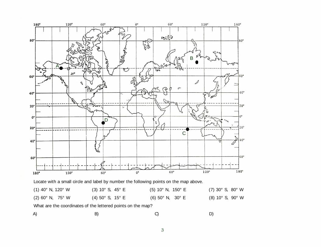
3
Locate with a small circle and label by number the following points on the map above.
(1) 40° N, 120° W (3) 10° S, 45° E (5) 10° N, 150° E (7) 30° S, 80° W
(2) 60° N, 75° W (4) 50° S, 15° E (6) 50° N, 30° E (8) 10° S, 90° W
What are the coordinates of the lettered points on the map?
A) B) C) D)
A B
C
D
Geography September 2008
2
GEG 1 ASSESSMENT PROJECT 2: MAP SCALE
Summary Issue: There is a scale problem on the first exam. Student success is not as high as expected. Strategy: Revise in-class assignment. Include scale problem on the study guide for the exam and on the in-class review. .

Name ________________________ Date _________________
Physical Geography Chapter 2
Scale Below are measured distances (in inches) at several different scales. Show the calculations necessary to translate the map distances to real world distances. To determine feet divide by 12. To determine miles, divide by 63,360. To convert a fraction to a decimal, divide the numerator by the denominator. Set up the equations exactly as shown in the following example. 2.5 inches at 1:100,000. What is the distance in miles? 2.5 x 100,000 63,360 1) 2 inches at 1:24,000. What is the distance in feet? 2 x 24,000 12 2) 4.5 inches at 1:24,000. What is the distance in feet? 4.5 x 24,000 12 3) 3 inches at 1:62,500. What is the distance in miles? 3 x 62,500 63360 4) 3.5 inches at 1:250,000. What is the distance in miles? 3.5 x 250,000 63360 = 5) 4/16 inches at 1:24,000. What is the distance in feet?

Geography September 2008
3
GEG 1 ASSESSMENT PROJECT 3: LATITUDES AND SEASONS
Summary Issue: Latitude identification is on the first exam. Student success is not as high as expected. Strategy: Revise in-class assignment. Include on the study guide for the exam and on the in-class review.

Equator
Vertical rays
SUN
Write the names of the lines identified by letters.
Write the degree of each line identified by letter.
AB
C
G
F
E
D
AB
C
D
E
F
G
A. ______________________________
B. ______________________________
C. ______________________________
D. ______________________________
E. ______________________________
F. ______________________________
G. ______________________________
4a. What is the name of this event? ____________________
4b. What is the date of this event? _____________________
A. ______________________________
B. ______________________________
C. ______________________________
D. ______________________________
E. ______________________________
F. ______________________________
G. ______________________________
There are seven lines of latitude that are particularly important to us. Learn thier
names and degrees.
Name ____________________________ Date _________________
June Solstice
June 21

Geography September 2008
4
GEG 1 ASSESSMENT PROJECT 4: THE INTERNATIONAL DATE LINE
Summary
There is a question about the IDL on the first exam. Student success is not as high as expected. Strategy: Revise in-class assignment to include a map. Include IDL problem on the study guide for the exam and on the in-class review.
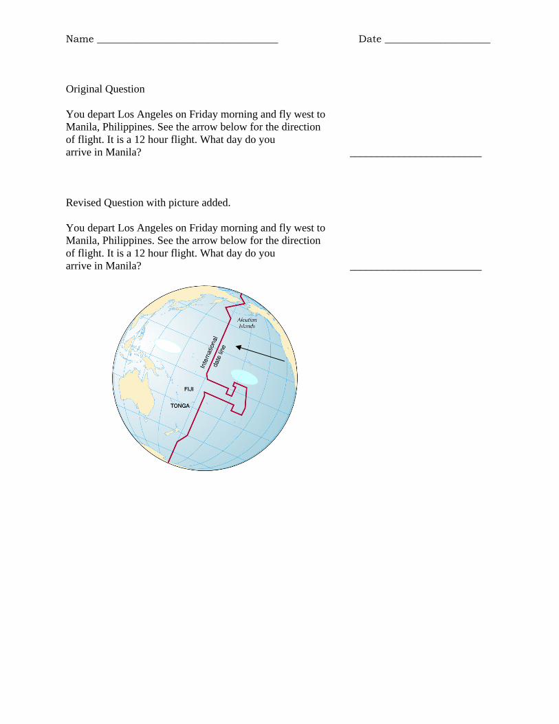
Name ____________________________________ Date _____________________
Original Question You depart Los Angeles on Friday morning and fly west to Manila, Philippines. See the arrow below for the direction of flight. It is a 12 hour flight. What day do you Saturday arrive in Manila? ________________________ Revised Question with picture added. You depart Los Angeles on Friday morning and fly west to Manila, Philippines. See the arrow below for the direction of flight. It is a 12 hour flight. What day do you Saturday arrive in Manila? ________________________

Geography September 2008
5
GEG 1 ASSESSMENT PROJECT 5: RAIN SHADOW
Summary
Issue: Students were asked to identify the location of a rain shadow on a graphic representation of a topographic barrier Strategy: None. Students were successful.
Geography September 2008
6
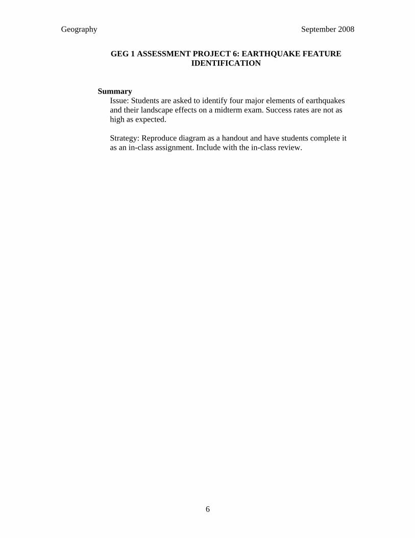
GEG 1 ASSESSMENT PROJECT 6: EARTHQUAKE FEATURE IDENTIFICATION
Summary
Issue: Students are asked to identify four major elements of earthquakes and their landscape effects on a midterm exam. Success rates are not as high as expected. Strategy: Reproduce diagram as a handout and have students complete it as an in-class assignment. Include with the in-class review.

Exam 4 ReviewEarthquake Cross-section
YX2
XZ
Identify the featuresindicated by the letters.

Geography September 2008
7
GEG 1 PROJECT 7: INTERPETING CLIMATE DATA
Summary Issue: Students are asked to identify a climograph as representing a southern hemisphere location. Success rates are not as high as expected. Strategy: Develop an in-class assignment. Include topic with the in-class review. Mention topic in the study guide for the exam.

SH A climate NH C climate
NH E ClimateD Climate
Draw typical temperature (TEMP) lines for each of the locations below. NH = Northern hemisphere SH = Southern hemisphere
Name ___________________________________________________

Geography September 2008
8
GEG 1 PROJECT 8: MONSOONS
Summary Issue: Students will be asked to correctly identify the seasonal wind patterns associated with monsoons when provided with a map. Students will be asked to explain wind patterns in term of high atmospheric pressure and low atmospheric pressure. Success rates are not as high as expected. Strategy: Develop in-class assignment. Include topic with the in-class review. Mention topic in the study guide for the exam.

Name __________________________________
Monsoons & Local Winds 1) High pressure is associated with ________________ surface temperatures and
low pressure is associated with _________________ surface temperatures. 2) Wind will flow from areas of _______________ pressure to _______________ pressure. 3) Wind will flow from areas of ________________ surface temperatures to
areas of _________________ surface temperatures. 4) For half of the year an ocean surface, such as the Indian Ocean, is associated with low pressure. For the
other half of the year, the same ocean area is associated with high pressure. The ocean temperature does not change very much throughout the year. Why does the pressure change? Explain fully.
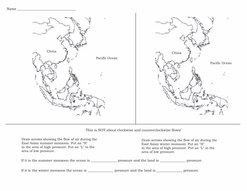
Pacific Ocean
China
Pacific Ocean
China
This is NOT about clockwise and counterclockwise flows!
If it is the summer monsoon the ocean is _______________ pressure and the land is _______________ pressure.
If it is the winter monsoon the ocean is _______________ pressure and the land is _______________ pressure.
Draw arrows showing the flow of air during the
East Asian summer monsoon. Put an "H"
in the area of high pressure. Put an "L" in the
area of low pressure.
Draw arrows showing the flow of air during the
East Asian winter monsoon. Put an "H"
in the area of high pressure. Put an "L" in the
area of low pressure.
Name __________________________________

Geography September 2008
9
GEG 1 ASSESSMENT SURVEY
The latest version of the end-of-term assessment is followed by the separate assessment about the structure of the class that will be administered separately.

Physical Geography
End of Term Assessment Revised Version Please consider these questions. Your input will help the instructor consider ways to improve the class. Your cooperation is greatly appreciated.
1) Which of the following best reflects your perception? ___ My map skills were NOT very good at the beginning of the semester/session and have NOT improved as a result of taking this class ___ My map skills were NOT very good at the beginning of the semester/session and have improved significantly as a result of taking this class ___ My map skills were good at the beginning of the semester/session and have NOT improved as a result of taking this class ___ My map skills were good at the beginning of the semester/session and have improved as a result of taking this class 2) Which of the following best reflects your perception? ___ My understanding of weather and atmospheric processes was NOT very good at the beginning of the semester/session and has NOT increased as a result of this class ___ My understanding of weather and atmospheric processes was NOT very good at the beginning of the semester/session and has increased significantly as a result of this class ___ My understanding of weather and atmospheric processes was very good and has NOT significantly increased as a result of this class ___ My understanding of weather and atmospheric processes was very good and has significantly increased as a result of this class 3) Which of the following best reflects your perception? ___ My understanding of life on Earth was NOT very good at the beginning of the semester/session and has NOT increased as a result of this class ___ My understanding of life on Earth was NOT very good at the beginning of the semester/session and has increased as a result of this class ___ My understanding of life on Earth was good at the beginning of class and has NOT significantly increased as a result of this class ___ My understanding of life on Earth was good at the beginning of class and has significantly increased as a result of this class

4) Which of the following best reflects your perception? ___ My understanding of Earth’s landscape processes (plate tectonics, mountains, earthquakes, etc.) was not very good at the beginning of class has NOT increased as a result of this class ___ My understanding of Earth’s landscape processes (plate tectonics, mountains, earthquakes, etc.) was not very good at the beginning of class and has increased as a result of this class ___ My understanding of Earth’s landscape processes (plate tectonics, mountains, earthquakes, etc.) was good at the beginning of class and therefore NOT significantly increased as a result of this class ___ My understanding of Earth’s landscape processes (plate tectonics, mountains, earthquakes, etc.) was good at the beginning of class and has significantly increased as a result of this class 5) Which of the following best reflects your perception? ___ The in-class assignments were helpful in learning the material for the exams ___ The in-class assignments were not helpful in learning the material for the exams 6) Which of the following best reflects your perception? ___ My college level study skills were not very good at the beginning of the semester and have not improved as a result of this class ___ My college level study skills were not very good at the beginning of the semester and have improved as a result of this class ___ My college level study skills were very good at the beginning of the semester and as a result did not change significantly as a result of this class 7) How useful were the in-class exam reviews for your performance on the exams? ___ Not very helpful ___ Somewhat helpful ___ Very helpful 8) How useful were the individual questions from the instructor on lecture days and on the exam review sessions for your performance on the exams? ___ Not very helpful ___ Somewhat helpful ___ Very helpful

9) How useful were the online practice tests (not the chapter quizzes)? ___ I did not do the online pretests ___ Not very helpful ___ Somewhat helpful ___ Very helpful
10) The instructor tries to limit the lecturing in order to incorporate in-class assignments. Which of the following would you most agree with? ___ I would like more lecturing and less in-class work ___ I like the current balance of lecturing and in-class work ___ I would like less lecturing and more in-class work 11) Compared to high school science classes, how do you feel about this class? ___ Physical Geography is easier than a typical high school science class ___ Physical Geography has the same level of difficulty as a typical high school science class ___ Physical Geography is significantly more difficult than a typical high school science class ___ Unable to say
12) Compared to other classes here at Moreno Valley or any other college, how do you feel about this class? ___ Physical Geography has been easier than other college classes ___ Physical Geography has the same level of difficulty as other college classes ___ Physical Geography is significantly more difficult than other college classes ___ Unable to say 13) Compared to other science classes here at Moreno Valley or any other college, how do you feel about this class? ___ Physical Geography is easier than other college science classes ___ Physical Geography is the same level of difficulty as other college science classes ___ Physical Geography is significantly more difficult than other college science classes ___ Unable to say

14) How much did you utilize the WebCT site? ___ Rarely ___ Occasionally ___ Often 15) For those of you who did NOT utilize the WebCT site very much, which of the following best describes your situation. ___ I did not have a computer at home. ___ There was a computer at home, but it was not always working. ___ I have a computer at home, but no internet access ___ I have a computer and it is hooked up to the internet 16) Did you check your exam grades online? ___ Rarely ___ Occasionally ___ Often 17) Do you like being able to check your grades online? ___ Yes ___ No 18) Overall, how do you feel about the Web Enhanced component of the class? ___ I do not like the web enhanced component ___ I like the web enhancement 19) Which of the following best reflects your thinking? ___ I prefer to receive feedback from the instructor on my progress via email and WebCT ___ I prefer to receive feedback in person from the instructor 20) Which of the following best reflects your thinking? ___ I did not find this class intellectually stimulating ___ I found this class intellectually stimulating

21) What do you like best or least about the Web Enhanced component of the class? 22) What suggestions do you have to make the class better in any way and to increase student success? 23) Any suggestions for the syllabi? 24) Any suggestions for the WebCT site?

Physical Geography
CLASS ASSESSSMENT The instructor is interested in feedback from students on the structure of the class. Your input will help the instructor consider ways to improve the course. Your cooperation is greatly appreciated. The instructor tries to limit the lecturing in order to incorporate in-class assignments. Which of the following would you most agree with? ___ I would like more lecturing and less in-class work ___ I like the current balance of lecturing and in-class work ___ I would like less lecturing and more in-class work Please briefly explain your response to the question above.

Geography September 2008
10
GEG 1 EXAM REVIEWS

1
What is the name of this line?
1
What is the degree of this line?
2
What is the name of this line?
3
What is the degree of this line?
4
What is the name of this line?
5 6
Midlatitudes or Tropics?
{

2
What day is Earth at its perihelion?
7 8
Is this map conformal or equivalent?
How much is Earth tilted?
9
What is the name of this event?
Vertical Rays
of the Sun
10
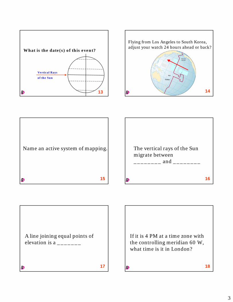
What is the date(s) of this event?
Vertical Rays
of the Sun
11
What is the name of this event?
Vertical Rays
of the Sun
12
3
What is the date(s) of this event?
Vertical Rays
of the Sun
13
Flying from Los Angeles to South Korea, adjust your watch 24 hours ahead or back?
14
Name an active system of mapping.
15
The vertical rays of the Sun migrate between________ and ________
16
A line joining equal points of elevation is a _______
17
If it is 4 PM at a time zone with the controlling meridian 60 W, what time is it in London?
18

4
If it is 9 PM Daylight Saving Time in Moreno Valley, what is the “true” time?
19
The Prime Meridian is a time zone.
T F 20
Compared to an 8.5" by 11" map of Moreno Valley, an 8.5" by 11" map of the world would be a large scale map.
T F 21
What is the degree of the highest latitude that can experience vertical rays of the Sun?
22
1 mile is equal to how many kilometers?
23
If it is 4:00 PM at a time zone with controlling meridian 45 W, what time is at 90 W?
24
5
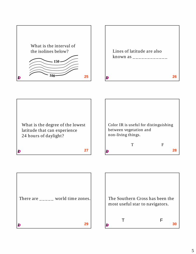
What is the interval of the isolines below?
100
150
25
Lines of latitude are also known as ____________
26
What is the degree of the lowest latitude that can experience 24 hours of daylight?
27
Color IR is useful for distinguishing between vegetation and non-living things.
T F28
There are _____ world time zones.
29
The Southern Cross has been the most useful star to navigators.
30T F
6
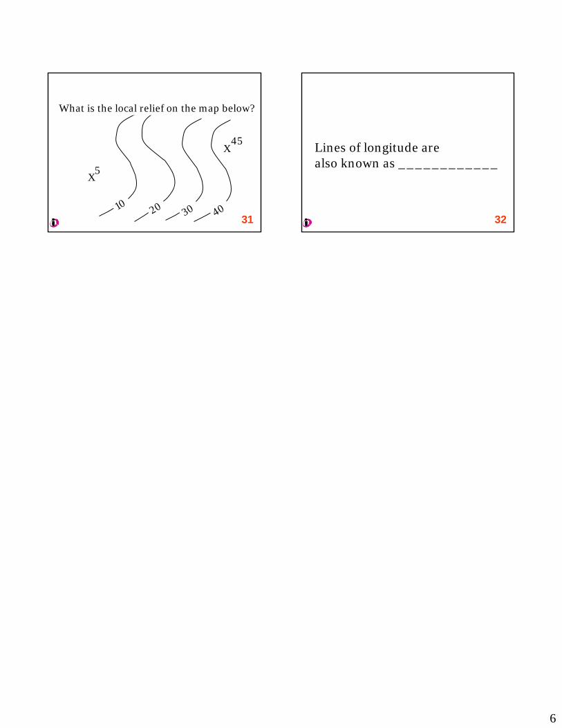
1020 30 40
X
X5
45
What is the local relief on the map below?
31
Lines of longitude are also known as ____________
32

PRS EXAM 2 REVIEW
1. Scale of a map is 1:20,000. Distance between two cities = 3 inches. How far apart in miles are the cities?
2. What are the 3 main gasses in the atmosphere?
3. What is the pattern of ocean currents in the northern hemisphere?
4. Warm surfaces are associated with ___________ pressure.
5. What are the 3 most important atmospheric gasses for weather and climate?
6. Rising air is associated with ___________ pressure.
7. Lines showing points of equal air pressure are known as _______
8. What is the ultimate cause of wind?
9. In the tropics, ________________ is primarily responsible for water droplets becoming raindrops.
10. Subtropical highs are centered at what latitudes?
11. Air moves from areas of ___________ pressure to areas of ____________ pressure.
12. What is the pattern of airflow in a northern hemisphere cyclone?
13. A midlatitude anticyclone is one air mass. T F
14. In a midlatitude anticyclone there is little wind. T F
15. In a midlatitude anticyclone there are two fronts, a warm front and a cold front. T F
16. The process of water going from liquid to a gas is_____________
17. In evaporation there is net loss or gain of heat for the atmosphere?
18. The warmer the water, the _________________ rate of evaporation.
19. What does it mean that air is saturated?
20. For condensation to occur, air must be ________________.
21. There are places in the world where it rains a lot. They are dominated by _______ pressure.
22. What is dew?
23. Which will tend to have more days of fog, the east or west coast of the USA?
24. Which of the two mechanisms for producing raindrops from water droplets is common in the midlatitudes?

25. What 2 processes are necessary for precipitation to occur?
26. Where are the wettest places on Earth?
27. On most continents, the west coast will tend to be wetter than the east coast. T F
28. Dry areas are usually located on the ________ side of continents.
29. __________ is the season of maximum precipitation in most parts of the world.
30. In the summer monsoon, the land is _________ pressure.
31. Most of the world’s desert are centered at what latitudes?
32. In the high latitudes there is little precipitation, water surfaces are cold, and there is little opportunity for moisture to evaporate. These regions are referred to as _________________
33. What is a rain shadow?
34. Places where it rarely rains are dominated by what type of pressure?
35. You are driving to campus on a cold winter morning. It is foggy. What explains the fog?
36. Santa Ana winds are an example of what type of downslope wind?
37. In the summer time, a high pressure cell is over the desert area known as the Great Basin. The wind in Moreno Valley will be from the _______.
38. The pattern of airflow around a midlatitude cyclone is __________.
39. On a weather map, a warm front is represented by __________________.
40. 41.
In what part of the world is convergent lifting common? In what part of the world is convective lifting common?
42. What is responsible for a heat wave?
43. Doldrums and horse latitudes are names for ________________________________.
44. Water and glass are good transmitters of longwave radiation. T F
45. In the midlatitudes the dominant wind direction is east to west. T F
46. A town on the leeward side of a topographic barrier will be in a rain shadow. T F
47. Incoming solar energy is ________________ radiation.

Is this place in the northern or southern hemisphere?
1
Exam 3 Review

Subtropical DesertsA B C D or E Climate?
2

A B C D or E Climate?
3

A B C D or E Climate?
4

A B C D E Climate?
5
PG EXAM 3 REVIEEW PRS
6. What is the geography of A climates?
7. What winds are associated with places that get a lot of rain?
8. What do steppe and tundra have in common?
9. At which latitudes are most dry climate zones located?
10. What do Mediterranean and Marine West Coast climates have in common?
11. What is the vertical movement of air in A climates?
12. Which A climate is driest?
13. Which C climate is driest?
14. What part of North America has a humid subtropical climate?
15. Which continents have D climates?
16. Can you name a highly populated continent without an H climate?
17. In the high latitudes there is little precipitation, water surfaces are cold, and there is little
opportunity for moisture to evaporate. These regions are referred to as ________________.
18. What percentage of solar energy is fixed in photosynthesis?
19. How old is “modern” Earth?
20. How does carbon get from the atmosphere into the biosphere?
21. What is biomass?
22. What percentage of carbon is in storage?
23. What is a dead zone?
24. What are the characteristics of places on land that have high net productivity?
25. What are primary consumers?
26. What is an ecosystem?
27. What is a perennial plant?
28. What are xerophytes?
29. What are the two main ways plants reproduce?

30. What does the term riparian refer to?
31. Pteridophytes, important now?
32. What are the two types of seed producing plants?
33. In vertical zonation, altitude is a counterpart to ___________
34. What is a deciduous tree?
35. Gymnosperms and angiosperms, which are older?
36. What is a woodland?
37. Which world region does not have true antelope?
38. What is mutualism?
39. Which one are there more of invertebrates or vertebrates?
40. 41.
What is the most numerous type of invertebrate? Are there more mammals or more fish in the world?
42. Are there more mammals or birds in the world?
43. Are there vertebrates that can breathe underwater? If so, what do we call them?
44. Are there mammals that can fly? If so, what do we call them?
45. What did birds evolve from?
46. What special characteristic do birds and mammals share?
47. What is a monotreme?
48. What distinctive fauna is found in New Zealand?
49. What distinctive fauna is found in Madagascar?
50. 90% of the trees in Australia are this type.
51. Most of the shrubs and bushes in Australia are this type.
52. What type of mammal is most common in Australia? .

PG PRS EXAM 4 REVIEW1 What temperatures and what moisture levels are associated with rapid soil
production?
2 What percentage of productive soil is mineral matter?
3 What percentage of productive soil is organic matter?
4 What percentage of productive soil is pore spaces?
5 What is the difference between litter and humus?
6 Plants get water in two ways, which is more important?
7 What is leaching?
8 What is field capacity?
9 What is wilting point?
10 What time of year would you expect soil to be at field capacity?
11 Silt-Sand-Clay: put in order from smallest to largest.
12 What is the name of the most productive soil texture?
13 What is solum?
14 What is salinization?
15 How does salinization occur?
16 What is calcification?
17 What is directional movement of water in the process of calcification?
18 Why is leaching rare in desert areas?
19 What are the main components of the lithosphere?
20 Which type of crust is thicker?
21 What is an outcrop?
22 All rocks were originally which type?
23 Most of the rock on the surface of Earth is which type?

24 The current geologic epoch is ______________
25 Which type of crust tends to be older?
26 What does the term “Pangaea” refer to?
27 What is subduction?
28 The name of the previous geologic epoch is ______________
29 What type of plate boundary do we find in the middle of the Atlantic Ocean?
30 What type of plate boundary is responsible for the Andes Mountains?
31 What type of plate boundary is responsible for the Himalaya Mountains?
32 Which plate boundaries are likely to make island arcs?
33 Which type of plate boundary is associated with lateral slippage, conservationof crust, and the San Andreas fault system?
34 On which tectonic plate is Moreno Valley located?
35 What is the geography of most earthquakes?
36 What is the direction of Moreno Valley's tectonic plate?
37 In which area of the US would you find accreted terranes?
38 What is responsible for the formation of the Hawaiian Islands?
39 In which direction are the Hawaiian Islands moving?
40 What type of volcano is Crater Lake?
41 What is the style of eruption of volcanoes with lots of silica?
42 What is a lahar?
43 What is diastrophism?
44 The east side of the Sierra Nevada Mountains is notable for a ____________
45
46
A layer of loose inorganic material with a crude gradation of particle sizes overlaying unfragmented rock is called
Liquefaction is

47
48
49
50
Which of the following is not an internal process?
Gold and silver are examples of what specific type of minerals?
A batholith is
The most common gas emitted during volcanic eruptions is

Geography September 2008
11
GEG 1 EXAM STUDY GUIDES
1
Physical Geography Midterm 1 Study Guide
The format of the exam will be a combination of multiple choice, fill-in-the-blank, true /false, and short answer. In addition, there will be some maps to interpret and there may be figures that you will be asked to explain. Approximately 85 to 90 percent of the test questions will be directly from the study guide, but anything mentioned in the textbook, lectures, assignments, presentations, or discussions could be on the exam. Studying in groups has proven to be a successful strategy. I highly recommend it. If you have questions be sure to talk with the instructor in class or visit him during office hours. He is eager to help you succeed. You should stop by during office hours to help make sure that you are on the right track. To study for the midterm utilize the following:
• The textbook • Your notes • The assignments
The most important study activity is to read and review the textbook chapters and reread any sections that you do not fully grasp. Pay particular attention to sections of the book, including figures that I have referred to in my lectures. Pay attention to words that appear in bold in the text and know their definitions. In using the study guide, DO NOT develop elaborate answers or statements to the items listed. A short definition, perhaps a two or three word phrase, or maybe one or two sentences should suffice. A good strategy is to develop a few answers and then show them to me. I will be happy to give you feedback as to whether your approach is good or not. Come see me in my office! Students sometimes comment that the wording of the questions tend to be particular. I am not trying to trick anyone; however I am interested in specific information. This is a science class. It is not good enough to only have a vague notion about what is being asked. It is essential that you have a firm grasp of the material.
• You will NOT need a calculator. • The presence or use of any electronic device is grounds for receiving a grade of
zero for the exam. • Do not leave the room when in the process of taking an exam.
Good luck! Remember that I want you to do well and I am here to help you if you are at an impasse, but you are responsible for learning the material.

2
Midterm One Introduction to Earth The inclination Earth and possible reason for inclination. When is Earth closest to the Sun? When is Earth farthest from the Sun? Seven major lines of latitude. Names and degrees. The significance of the Tropics of Cancer and Capricorn. The significance of the Arctic and Antarctic Circles. What is a solstice? What is an Equinox? When do they occur? Most important effect of Earth’s rotation. What places on Earth can experience 24 hours of daylight or darkness? Prime Meridian and International Date Line, where are they, how do they divide the world? Be able to recognize the Equator and Prime Meridian by knowing the countries that they pass through. Know how to map latitude and longitude. Know how to determine the latitude and longitude of a point. It is important to have a general sense of which continents are in the western hemisphere, which are in the eastern hemisphere, as well as which are in the northern and southern hemispheres. Understand the relationship between time zones and longitude. UTC and time. What is Daylight Savings Time? How does it work? What are controlling meridians and what purpose do they serve? What is the system for determining controlling meridians (if my controlling meridian is 90oE, what are the controlling meridians to the east and west)? International Date Line. Where is it, what is its degree? What happens to the day of the week when you cross the IDL going east? What happens to the day of the week when you cross the IDL going west? Read the two special sections, The Moon and Polaris.

3
Portraying the Earth Understand the concepts of large scale and small scale. How much area does each show, how much detail? Advantages of a globe, disadvantages of a globe. Advantages of a map, disadvantages of a map. Know how to determine distance in miles from a fractional scale. Example, if the scale of a map is 1:250,000 and the distance between two places is 3.5 inches, how far apart in miles are the locations? You have to memorize the number of inches in a mile. Know how to determine distance in miles from a fractional scale. What is scale? Different types of scale. Read the special section, Mercator: The Most Famous Projection. Important aspects of the Mercator Projection and its history, use and “misuse.” The basic characteristics of isolines. Know what each type of isoline represents: contour, isobar, isohyet, isotherm. How many kilometers is a mile? Know how to determine the interval of isolines on a map. Know the basics of reading and interpreting a contour map. Equivalence vs. conformality, know definitions. Active vs. passive systems of mapping. Know the basics about the following, what do they show, how do they look, what are they used for? GIS Landsat GPS Color IR Thermal IR

1
Physical Geography Midterm 2 (Chapters 3, 4, 5, 6, 7)
Study Guide Most of the questions will be fill-in-the-blank and multiple choice, and true /false. In addition, there will be some maps to interpret and there will be figures that you will be asked to explain. Approximately 85 to 90 percent of the test questions will be directly from the study guide, but anything mentioned in the textbook, lectures, assignments, presentations, or discussions could be on the exam. Studying in groups has proven to be a successful strategy. I recommend it. To study for the midterm utilize the following:
• The textbook • Your notes • The assignments
The most important study activity is to read and review the textbook chapters and reread any sections that you do not fully grasp. Pay particular attention to sections of the book, including figures that I have referred to in my lectures. Pay attention to words that appear in bold in the text and know their definitions. Students sometimes comment that the wording of the questions tend to be particular. I am not trying to trick anyone; however I am interested in specific information.
• You will NOT need a calculator. • The presence or use of any electronic device is grounds for receiving a grade of
zero for the exam. • Do not leave the room when in the process of taking an exam.
In using the study guide, DO NOT develop elaborate answers or statements to the items listed. A short definition, perhaps a two or three word phrase or maybe one or two sentences should suffice. A good strategy is to develop a few answers and then show them to me during office hours. I will be happy to give you feedback as to whether your approach is good or not. Come see me in my office! Basic mapping skills will be utilized and tested throughout the semester. Prime Meridian and International Date Line--where are they, how do they divide the world? Be able to recognize the Equator and Prime Meridian by knowing the countries that they pass through. Know how to map latitude and longitude. Know how to determine the latitude and longitude of a point. Review working with map scale. Special sections: Depletion of the Ozone Layer, Global Warming and the Greenhouse Effect, Air Pollution, Acid Rain. Good luck! Remember that I want you to do well and I am here to help you if you are at an impasse, but you are responsible for learning the material.
2
Midterm Two Topics The Atmosphere The thee major gas components of the atmosphere. The three atmospheric gasses that play significant roles in weather and climate. The structure of the atmosphere. Thermal layer where weather occurs. Definitions of weather. Definition of climate. Benefits of ozone in the upper atmosphere. What is happening to the Ozone Layer? To what do many scientists attribute changes in ozone levels? Examples of effects of the changes in ozone levels. The geography of changes in ozone levels. What areas are most affected and why? Continental vs. maritime climates / Distribution of land and water What are particulates, why are they important to weather? Is the atmosphere uniform? Explain. General circulation of the oceans, basic pattern. Two cities are on different sides of a mountain range. One city gets a lot of precipitation; one city gets very little precipitation. Explain and give an example. Insolation and Temperature Connection between the angle of incidence and the concentration of energy. Longwave vs. shortwave radiation. Blackbody Absorption and reflection. The absorption and reflection capacities of the following: rocks and soil; snow and ice; water. Scattering. Example of scattering. Transmission. Example of transmission (Hint: Figure 4-11). Convection and Conduction. The conduction capacity of Earth. Earth’s energy budget & the heating of the atmosphere. Global warming: The benefits of a greenhouse effect. What is the main cause of the warming trend of the Earth? Evidence of global warming, 2 or 3 examples. Land and water contrasts, implications. Circulation of major ocean currents in the northern and southern hemispheres (clockwise or counterclockwise). Cool / dry sides of continents. Warm/wet sides of continents. Adiabatic cooling and warming.
3
Atmospheric Pressure and Wind Cyclones and anticyclones. What are they? Directions of rotations? Converging and diverging air patterns. Definition of wind. Trade winds. Which way do they flow? In what latitudes do they occur? Westerlies. Which way do they flow? In what latitudes do they occur? Hadley cells: Where are they located? Two major wind systems they drive. Latitudes of ascending air, latitudes of descending air. Cloudy areas, windless areas, areas of clear skies. What is a subtropical high? Over what areas are they located and at what latitudes? ITCZ. Wind in ITCZ. Is the ITCZ fixed or does it move? If so how and what are the impacts of its movements? Rossby Waves, what are they? Importance to weather. Two islands are very close to each other. One island is a desert while the other island receives a great deal of rain. Explain how the two places can have such different precipitation patterns. Modifications of General Circulation: Monsoons. Why do monsoons occur? Two most important areas where monsoons play an important role in weather and climate. Seasonality of monsoons. How does shift of the ITCZ affect monsoons? A body of water that does not change temperature can be an area of high pressure in the daytime and then be an area of low pressure at night. Explain how the transformation can occur with no change in the temperature of water. What would be the direction of the wind in the daytime? What would be the direction of the wind at night? Examples and general names of cold downslope winds and warm downslope winds. Our local name for warm downslope winds. Atmospheric Moisture Relative humidity, times of days it is highest and lowest. What is evaporation? What is condensation? What is the dew point? Condensation nuclei- most common. Three main types of clouds and their characteristics. What type of fog does San Francisco get? What type of fog does Moreno Valley get? Collision/ coalescence. Geography of collision/ coalescence.

4
Ice crystal formation. Geography of ice crystal formation. Stable and unstable air. Visual determinations. What two events are necessary for significant precipitation? Four types of atmospheric lifting and where they are likely to occur. Geography of precipitation, basic, general patterns. Where are dry lands more prominent? What does the term “cold desert” refer to? What areas of Earth receive the most precipitation? What season is the time of maximum precipitation in most of the world? What is precipitation variability? Where is it high, where is it low? Transient Atmospheric Flows and Disturbances Definition of a front. Symbols for warm and cold fronts. Why are midlatitude cyclones important to weather? Characteristics and geography of midlatitude cyclones. Lifespans and movements of midlatitude cyclones. Midlatitude anticyclones. What is it? Size in relation to midlatitude cyclones, general direction of movement? Circulation of wind (clockwise or counterclockwise). (Hint: Figure 7-13 8th ed), Figure 7-16 9th ed.) Do they have fronts? Required temperature of water for hurricanes. Source of energy for hurricanes. Amount of energy produced by a mature hurricane. Geography of hurricanes, where do they originate, where do they travel? Main reason for general directions, where are the biggest ones? Seasonality of hurricanes. What is storm surge? What side of the hurricane does it affect (northern hemisphere). Positive dimensions of hurricanes. Are tornadoes low pressure or high pressure systems? General direction of tornadoes. The geography of tornadoes. Seasonality of tornadoes

1
Physical Geography Third Exam (Chapters 8, 10, 11)
Study Guide To prepare for the exam, make sure you have carefully read the chapters that will be covered, paying particular attention to topics that have been discussed in the lectures. In addition to reviewing your lecture notes, review notes from any documentaries we have watched. Review the take-home assignments and in-class assignments that were done. If you did poorly on previous exams and you are sincerely interested in doing better and passing the class, I expect to see you in my office one or two times before the exam. Of course, it would be helpful for everyone to come by and review. Do well on the exam. It will be good for you and good for me! Special sections: Environmental Relationships, Climatic Distribution in Africa, Wildfires in Yellowstone, Animal Adaptations to Desert Life, Biotic Rearrangement, Rainforest Removal. Basic mapping skills will be utilized and tested throughout the semester. Where are the Prime Meridian and International Date Line? How do they divide the world? Be able to recognize the Equator and Prime Meridian by knowing the countries that they pass through. Know how to map coordinates. Know how to determine the latitude and longitude of a point. Review map scale. This guide will address approximately 85% of the third exam. Climate Zones Understand the main characteristics of the A, B, C, and D major climate groups and their locations. Refer to the assignment for chapter 8. What spatial pattern do you see about places with record amounts of rainfall? What winds are involved in places where it rains a great deal? Be able to associate specific climographs to specific climatic zones. What do steppe and tundra have in common? Hadley cells, ITCZ, and STHs, how do they help explain global climate patterns? How and why are eastern sides of continents different than western sides? Vertical movement of air in A climates. Vertical movement of air in B climates. What do the terms “low sun” and “high sun” seasons refer to? What is vertical zonation? What are H climates? Where are they found/ not found? Where are D climates? Where are they found /not found? At what latitudes are most arid climate zones located? What are the precipitation patterns of each of the three A climates? What is the difference between steppe and desert? Example and full explanation of a double rain shadow.
2
Cycles and Patterns in the Biosphere What is photosynthesis, what organisms do it? Percentage of solar energy that is fixed in photosynthesis. What is biomass? Percentage of carbon being cycled at any given time. Percentage of carbon that is in storage at any given time. Connection between vegetable life and oxygen. Effect of buildup of nitrogen in water and example. Bioaccumulation: definition and example. Herbivores and carnivores. Primary vs. secondary consumers. Characteristics of places on land and in water with high photosynthesis productivity Definition of ecosystem. Definition of biome. What is the main energy source of the biosphere? How does carbon get from the atmosphere to the biosphere? Terrestrial Flora and Fauna Cattle egrets as examples of migration of animals. An example of plant migration. What is plant succession? Extinction. Perennials vs. annuals. Xerophytic adaptations. What are succulents? Spore reproducing plants-Pteridophytes. Are they important now? Seed producing plants. Gymnosperms and angiosperms. Which are older, which are dominant now? Evergreen vs. deciduous Climax vegetation What is riparian vegetation? Major floristic associations. Vertical Zonation- what is it? Categories. Symbiosis: mutualism and commensalisms. Examples of parasitism What does it mean that an animal is endothermic? Of all animals, which type is most abundant? Characteristics of mammals. Evolution of birds. Do birds and humans share any characteristics? Marsupials and monotremes. What are they? Are they mammals? Reasons for uniqueness of flora and fauna in Australia. Uniqueness of animals the following zoogeographic regions: Madagascar, New Zealand, Australia. What are antelope? Where are they found / not found?

1
Physical Geography Exam 4 (Chapters 12, 13, 14)
Study Guide To prepare for this exam, make sure you have carefully read the chapters we have discussed since the last exam, paying particular attention to topics that have been covered in the lectures. In addition to reviewing your lecture notes, review any notes from documentaries we have watched. Review the take-home assignments and in-class assignments that were done. If you did poorly on previous exams and you are sincerely interested in doing better and passing the class I expect to see you in my office one or two times before the exam. Intersession students should not hesitate to make an appointment. Of course, it would be helpful for everyone to come by and review. Do well on the exam. It will be good for you and good for me! Basic mapping skills will be utilized and tested throughout the semester. Prime Meridian and International Date Line--where are they, how do they divide the world? Be able to recognize the Equator and Prime Meridian by knowing the countries that they pass through. Know how to map latitude and longitude. Know how to determine the latitude and longitude of a point. Review working with map scale. Special sections: Earthworms in the Soil, An Example of Scale, The Pacific Ring of Fire, Earthquakes. This guide will address approximately 85% of the exam. Soil Lithosphere Regolith Bedrock Parent material Characteristics of places where soil tends to be deepest. Characteristics of places where soil tends to be shallow. Biological factors in soil productivity and examples. Humus, what is it and characteristics? Pedoturbation, what is it and an example? Soil spaces, what can they be filled with? Percolation vs. capillary action, what are they, which is more important to plants. Field capacity vs. wilting point. Seasonality of each. Leaching, what is it and how does it happen? Leaching in desert areas, extensive or not? Calcification vs. salinization, what are they and how do they happen? Movement of water in each. Relative sizes of silt, clay, and sand in soil. What is best texture for productive soil? Distribution of soils in the US compared to the world as a whole, similar or different?

2
Introduction to Landform Study Vertical structure of the Earth’s interior. Components of the lithosphere? What is continental drift? Igneous rock, sedimentary rock, & metamorphic rock Know how each is formed and what each looks like. Be able to explain the rock cycle Relative frequency of rock classes. Surface distribution of rock classes for the world. Definition of Geomorphology Definition of Uniformitarianism Age of Earth. Internal Processes Pangaea; Where was North America originally? Australia? India? Major tectonic plates. What is seafloor spreading-examples of where this is happening. What is subduction- examples of where this is happening. Two types of crusts. Relatives ages of crusts. Plate Boundaries and features associated with them. Prominent examples. Divergent Convergent (oceanic & oceanic) (continental & continental) (oceanic & continental) Accreted terrain and an example. What is the “Ring of Fire?” Where is it? What are hot spots (mantle plumes) and an example. Explanation of Hawaiian Islands. Which of the Hawaiian Islands have active volcanoes? Hawaiian Islands and Pacific Plate movement. Geography of volcanoes Types of volcanoes and eruptive styles. (see figures in book). What determines type of eruption? Relative sizes of different types of volcanoes. Volcanic hazards: Figure 14-29 (14-39 9th ed.) What is flood basalt and give an example. Caldera and an example. What is a batholith? What is diastrophism? Faulting (see figures in book, be able to recognize): Normal Fault, Reverse fault, Transform boundary/ strike slip fault. What is a fault scarp- prominent example. 2 examples of prominent examples of folding in the US. Horst vs. Graben Geography of earthquakes. Strongest earthquakes happen at what type of plate boundary? P waves- type of shaking they produce S waves- type of shaking they produce Which travel faster S or P waves? Earthquake: focus; epicenter; fault scarp; fault: Figure 14-f (14-57 9th ed.) What is earthquake magnitude?


