82


The Delaware Valley Regional Planning Commission is
dedicated to uniting the region’s elected officials, planning
professionals and the public with the common vision of
making a great region even greater. Shaping the way we
live, work and play, DVRPC builds consensus on improving
transportation, promoting smart growth, protecting the
environment, and enhancing the economy. We serve a
diverse region of nine counties: Bucks, Chester, Delaware,
Montgomery and Philadelphia in Pennsylvania; and
Burlington, Camden, Gloucester and Mercer in New
Jersey. DVRPC is the federally designated Metropolitan
Planning Organization for the Greater Philadelphia Region
— leading the way to a better future.
The symbol in our logo is adapted from the official DVRPC seal, and is designed as a stylized image of the Delaware Valley. The outer ring symbolizes the region as a whole. The diagonal line represents the Delaware River and the two adjoining crescents represent the Commonwealth of Pennsylvania and the State of New Jersey.
DVRPC is funded by a variety of funding sources including federal grants from the U.S. Department of Transportation’s Federal Highway Administration (FHWA) and Federal Transit Administration (FTA), the Pennsylvania and New Jersey departments of transportation, as well as by DVRPC’s state and local member governments. The authors, however, are solely responsible for the findings and conclusions herein, which may not represent the official views or policies of the funding agencies.
DVRPC fully complies with Title VI of the Civil Rights Act of 1964 and related statutes and regulations in all programs and activities. DVRPC’s website may be translated into Spanish, Russian and Traditional Chinese online by visiting www.dvrpc.org. Publications and other public documents can be made available in alternative languages and formats, if requested. For more information, please call (215) 238-2871.
Table of Contents
Executive Summary.........................................................................................................................................................................1 C H A P T E R 1
Introduction......................................................................................................................................................................................3 What is a Road Safety Audit (RSA)? ........................................................................................................................................3 The CR 534 (Blackwood-Clementon Road) Audit Event ..........................................................................................................4
C H A P T E R 2
Corridor Description and Analysis ...................................................................................................................................................5 Study Location ..........................................................................................................................................................................5 Roadway Characteristics ..........................................................................................................................................................5 Traffic Volumes .........................................................................................................................................................................6 Transit Service ..........................................................................................................................................................................6 Crash Findings ..........................................................................................................................................................................7
C H A P T E R 3
Findings and Recommendations.....................................................................................................................................................9 C H A P T E R 4
Conclusions ...................................................................................................................................................................................17
Tables Table 1: Corridor-wide Issues and Strategies ............................................................................................................................................................ 9 Table 2: Site-Specific Issues and Strategies............................................................................................................................................................ 12

Appendices A P P E N D I X A
Audit Team ................................................................................................................................................................................. A–1 A P P E N D I X B
Corridor-wide Data ..................................................................................................................................................................... B–1 A P P E N D I X C
CR 534 (Blackwood-Clementon Road) in the Vicinity of Erial Road (east and west) and NJ 42 Interchange ..........................C–1 Location-Specific Data .........................................................................................................................................................C–1
A P P E N D I X D
CR 534 (Blackwood-Clementon Road) at CR 759 (Little Gloucester Road)..............................................................................D–1 Location-Specific Data .........................................................................................................................................................D–1
A P P E N D I X E
CR 534 (Blackwood-Clementon Road) from Cherrywood Drive to Millbridge Road.................................................................. E–1 Location-Specific Data ......................................................................................................................................................... E–1
A P P E N D I X F
CR 534 (Blackwood-Clementon Road) at Kelly Driver Lane...................................................................................................... F–1 Location-Specific Data ......................................................................................................................................................... F–1
A P P E N D I X G
CR 534 (Blackwood-Clementon Road) at CR 673 (Laurel Avenue / College Drive) .................................................................G–1 Location-Specific Data .........................................................................................................................................................G–1

1
Executive Summary
This document is the final report for the CR 534 (Blackwood-Clementon Road) Road Safety Audit (RSA). This project represents a step towards implementation of the Delaware Valley Regional Planning Commission’s (DVRPC) Safety Action Plan. In fiscal year 2009, two RSAs were conducted on New Jersey’s county route system as part of DVRPC’s Transportation Safety Program. These RSAs improve and promote transportation safety on the region’s roadways while maintaining mobility. An RSA is an effective way of identifying crash-causing issues and effective solutions utilizing a nontraditional approach.
The RSA process began by identifying a hierarchy of county routes ranked by crash frequency. County-specific and regionwide lists of five-mile county route segments were distributed to county partners. Each county recommended candidates from the list for consideration in the program. DVRPC staff collaborated with the Camden County Planning and Engineering departments to hone in on the section of CR 534 (Blackwood-Clementon Road) chosen for the audit. The five-mile section of this route that resulted from the initial analysis ranked highest in crash frequency for the three-year period of 2005–2007. Camden County recommended a 1.9 mile subsection that is a high priority corridor for the county. The Laurel Road intersection, located at the east end of the study area, had been upgraded prior to the audit. Although data was gathered for this location, the audit team did not concentrate on this location due to the recent upgrades.
The CR 534 RSA was conducted on Wednesday, June 3, 2009. The pre-audit and post-audit meetings were held at the Camden County Department of Public Works, 2311 Egg Harbor Rd, Lindenwold, New Jersey. Due to the short length of the study corridor, the audit was able to be completed in one day. The audit team of 10 participants included representation from the Camden County Department of Public Works (planning and engineering departments), New Jersey Department of Transportation (NJDOT) Bureau of Safety Programs, New Jersey Division of Highway Traffic Safety (NJDHTS), Gloucester Township Police, Federal Highway Administration (FHWA), and DVRPC. The Bicycle Coalition of Greater Philadelphia was invited but unable to attend. See Appendix A for the list of audit team members.
One of the locations that the audit team spent a good deal of time discussing is at the western end of the study corridor where Blackwood-Clementon Road meets Erial Road and the NJ 42 interchange. These intersections are closely spaced—within an 800-foot span. There is a heavy flow of traffic from NJ 42 southbound to Camden County College which is located south of the study area and accessible via Erial Road. This traffic exits NJ 42, turns right onto Blackwood-Clementon Road eastbound, then turns right onto Erial Road southbound. Of the four focus areas this location had the highest concentration of crashes. The main problems are high speed, lack of lane delineation, and the short length of the road segment between the off-ramp and the Erial Road intersection. In addition, sight distance is compromised for NJ 42 off-ramp traffic as well as for pedestrians crossing Erial Road along eastbound CR 534. The recommendations for this location are comprehensive, including better lane delineation, traffic calming, improved sight distance, and pedestrian crossing improvements. This location will also benefit from a NJDOT project currently examining this NJ 42 interchange.

2
Regarding corridor-wide problems, signal coordination was identified as missing for most of the signals along the corridor. Signal placement and fixture types were inconsistent causing visual clutter and confusion. The study recommends that a signal inventory be undertaken to address these issues comprehensively. Additionally, pedestrian access is not consistently available throughout the corridor. Specific locations and improvement recommendations are discussed in Chapter 3.
The recommendations herein were developed collaboratively with roadway owners and local stakeholders from the study task force; DVRPC served as facilitator. The study partners have expressed interest in implementing many of the recommendations as time and funds allow. Many of the maintenance items, which are typically low cost, can be addressed without additional engineering.
3
C H A P T E R 1
Introduction
As the final report for the CR 534 (Blackwood-Clementon Road) RSA, this document represents a step towards implementation of DVRPC’s Regional Safety Action Plan. The RSA process utilizes a nontraditional approach to address crash problems through an intensive and collaborative forum. The Blackwood-Clementon Road RSA is one of two RSAs conducted on New Jersey’s county route system as part of DVRPC’s FY 2009 transportation safety work program. Since NJDOT focuses mainly on the state system routes, DVRPC’s focus on county routes in New Jersey gives attention to corridors that are regionally significant but not typically considered by the state.
Using Plan4Safety, DVRPC queried NJDOT’s crash database for a list of county-specific five-mile county route segments that experienced a high crash frequency during the three-year study period. The section of Blackwood-Clementon Road that resulted from this analysis ranked number one in crash frequency in the county. Camden County recommended a 1.9 mile subsection of the five-mile corridor to complement work completed on adjacent sections of Blackwood-Clementon Road.
What is a Road Safety Audit (RSA)?
An RSA is a formal safety performance examination of an existing or future road or intersection by a multi-disciplinary audit team. Road safety audits can be used on any size project, from minor maintenance to mega-projects, and can be conducted on facilities with a history of crashes, or during the design phase of a new roadway or planned upgrade. To date DVRPC has mostly used the tool on roadways of five miles in length or less where there is a demonstrated history of crashes.
The road safety audit program is conducted to generate improvement recommendations and countermeasures for roadway segments demonstrating a history of, or potential for, a high frequency of motor vehicle crashes, or an identifiable pattern of crash types. The emphasis is placed on identifying low-cost, quick-turnaround safety improvements to address issues where possible, though not excluding more complex strategies. Implementation of improvement strategies identified through this process may be eligible for Local Federal Aid Safety Funds. Because the RSA process is adaptable to local needs and conditions, recommendations can be implemented incrementally as time and resources permit.

4
Prior to the one-day audit event, DVRPC collects and analyzes relevant data, including: crash cluster and corridor-wide crash summary analyses, daytime and nighttime video of the roadway, traffic volume data, intersection turning movement volume data, and aerial photographs. DVRPC staff also conducts a pre-audit field visit to examine conditions and take photographs. The identified crash clusters became focus areas during the audit of CR 534.
The audit event has three basic components which the audit team participates in:
Pre-audit – the study team reviews location characteristics and crash analysis;
Field visit – the study team examines conditions along the corridor, preferably on foot; and
Post-audit – the study team shares findings, and develops a list of problems and potential strategies.
Following the event, DVRPC staff compiles the identified problems and potential strategies into a matrix. This document is sent back to the audit team for verification. Upon approval from the team, the matrix is incorporated into a technical report. This is then distributed to all audit participants and coordinating agencies for advancement to the implementation stage.
The CR 534 (Blackwood-Clementon Road) Audit Event
The one-day road safety audit was conducted on Wednesday, June 3, 2009. The pre-audit and post-audit meetings were held at the Camden County Department of Public Works, 2311 Egg Harbor Rd, Lindenwold, New Jersey. The audit team of 10 participants included representation from local, county, regional, state, and federal levels. The Bicycle Coalition of Greater Philadelphia was invited but unable to attend. See Appendix A for the list of audit team members.
The pre-audit meeting—an overview of the study area and an examination of crash history—began at 8:30 AM. A video showing the corridor under nighttime conditions was also shown. Next was the field visit, when the audit team walked the corridor and examined conditions to identify safety issues. After lunch the team returned to the meeting room for the post-audit session where problems were defined and countermeasures discussed.

5
C H A P T E R 2
Corridor Description and Analysis
Study Location
The study area consists of approximately 1.9 miles of CR 534 from the NJ 42 interchange to the Laurel Road intersection, all within Gloucester Township, New Jersey. This stretch of Blackwood-Clementon Road is predominantly commercial. The strip developments and shopping plazas are broken up by a few sections of open space; i.e., preserved land and sports fields. No residential units front Blackwood-Clementon Road in the study section.
Roadway Characteristics
CR 534 (Blackwood-Clementon Road) is classified as an urban principal arterial. The corridor study section has a five-lane configuration throughout most of its length; two travel lanes per direction with a two-way-left-turn-lane (TWLTL) and no shoulders. Toward the eastern end of the study section the roadway transitions to three through lanes westbound; eastbound is unchanged and the TWLTL remains. During the audit process it was not immediately apparent why this extra capacity was added. Blackwood-Clementon Road’s horizontal alignment is straight. There is a very gentle rise and fall of grade within the study limits. The speed limit is posted at 40 MPH. There are eight signalized intersections and multiple driveways along this section. Sidewalks are consistently available through most of the five-lane cross-section, but several missing links were found. Sidewalk conditions vary from newly installed to needing maintenance. There are missing sections at the following locations:
Between the two legs of Erial Road – westbound
Between Peters Lane and Woodlane Drive – westbound
Between Little Gloucester Road and the shopping center access – eastbound, westbound
Between the shopping center access and Millbridge Road – westbound
Between Millbridge Road and College Drive – eastbound

6
Traffic Volumes
Total volume counts were taken for the audit in the spring of 2009. The resulting data shows consistent traffic volumes along the corridor. This section of Blackwood-Clementon Road has an average annual daily traffic (AADT) count of 25,000 to 28,000 with nearly equal volumes by direction. AADTs can be found in Appendix B.
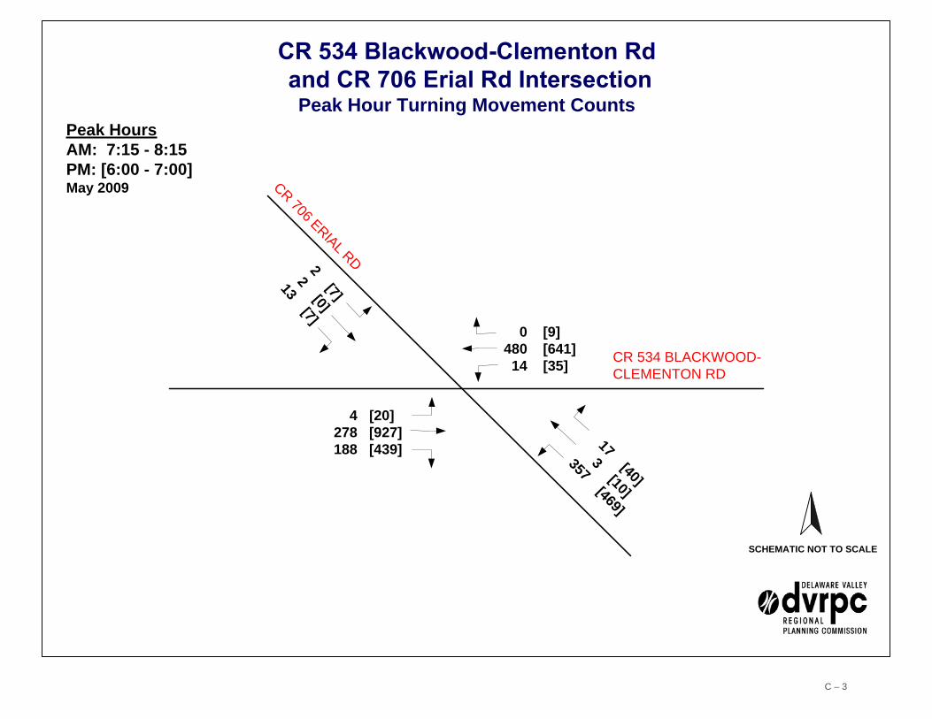
Turning movement counts were taken at three signalized locations: 1) at CR 706 (Erial Road) 2) at Kelly Driver Lane and 3) at CR 759 (Little Gloucester Road). Erial Road, located at the western end of the study corridor, provides access to Camden County College and carries a significant volume of traffic between Blackwood-Clementon Road and the school. Left turns from Erial Road northbound to Blackwood-Clementon Road westbound, and right turns from Blackwood-Clementon Road eastbound to Erial Road southbound, rival through movements along Blackwood-Clementon Road and are by far the heaviest turn movements at this intersection. This is because of Erial Road’s proximity to NJ 42 which carries the lion’s share of college-bound motorists according to the study team. The peak hours were identified as 7:15 – 8:15 AM and 6:00 – 7:00 PM. Turning movement counts for the intersection can be found in Appendix C.
At the Little Gloucester Road intersection, the combined northbound and southbound through traffic volumes are equal to about half the volume of through traffic on Blackwood-Clementon Road. These higher numbers may reflect Little Gloucester’s alignment as a north-south cross-county route. The peak hours were identified as 8:00 – 9:00 AM and 4:45 – 5:45 PM. Little Gloucester Road also provides access to a shopping center which may contribute to the late morning and early evening peaks. Turning movement counts for the intersection can be found in Appendix D.
The Kelly Driver Lane intersection has only one dominant turn movement: Kelly Driver Lane southbound left turn onto Blackwood-Clementon Road eastbound. This movement averages about 160 vehicles per peak hour, while the remaining turns from all approaches experience less than 90 movements per peak hour. The peak hours were identified as 8:00 – 9:00 AM (same as Little Gloucester Road) and 6:00 – 7:00 PM. Turning movement counts for the intersection can be found in Appendix F.
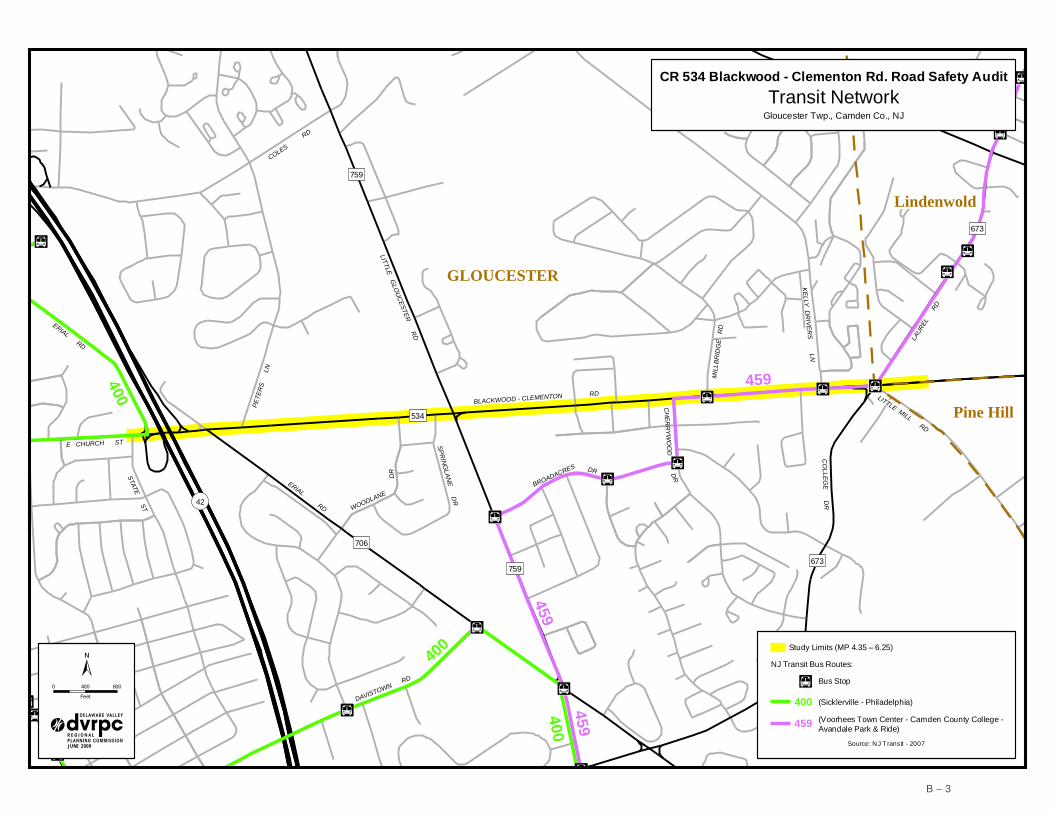
Transit Service
There is only one transit route that passes through the study area. The NJ Transit #459 bus follows a roughly north-south alignment and serves the study corridor along Blackwood-Clementon Road between Cherrywood Drive and Laurel Road. Marked bus stops can be found at the Millbridge Road, Kelly Driver Lane, and Laurel Road intersections. According to NJ Transit’s ridership data collected in July of 2007, the #459 bus carries an average of 849 passengers per weekday, 442 passengers on Saturdays, and drops to 198 on Sundays.

7
Crash Findings
According to the NJDOT crash database, there were 428 reportable crashes from 2005 to 2007 along the study area section of CR 534 (Blackwood-Clementon Road). Reportable crashes are crashes that result in a fatality, injury, and/or property damage of $500 or more. A comprehensive analysis of the corridor-wide crash data is shown in Appendix B. Of the three-year total, 160 crashes occurred in 2005 (37.4%), 126 in 2006 (29.4%), and 142 in 2007 (33.2%).
When analyzing crash frequency by month, the fewest crashes occurred in August (25), and May had the highest number with 44. Despite this wide disparity, the remainder of the year was fairly consistent, hovering around 35 per month on average. Crashes were somewhat evenly distributed between Monday and Friday with the fewest occurring on Tuesdays (55) and the most on Fridays (75). The lowest overall total was recorded on Sundays (36) representing eight percent of the total. This corridor is a heavily traveled commuter route and generates a significant amount of retail traffic. When considering crashes by time of day, the distribution favors the nine-hour period from 11:00 AM to 7:00 PM when 63 percent of the crashes occurred. Comparatively speaking, there is a noteworthy spike in crashes during the morning commute at 7:00 AM; 22 crashes were recorded.
Road surface and light condition crash distributions were mostly consistent with state averages for county routes. The percentage of dusk and nighttime crashes each exceeded the state average by just over two percent. These numbers may be related to lighting conditions along the corridor. Regarding severity, there was one fatal crash. One hundred forty-five crashes (33.8%) involved an injury, while the remaining 282 crashes resulted in property damage only (65.8% of the total).
Several collision types exceeded state averages along the study corridor for the three-year analysis period. Comparing corridor crash statistics with state averages puts the crash experience in perspective and allows for examination of over-representations by category.
The most common collision type along the corridor was rear-end crashes, accounting for 40.4 percent, which was above the state average of 30.6 percent. Rear-end crashes tend to be common along signalized roadways, especially those with recurring congestion. Angle collisions (22.4%) were second most common and were just above the state average of 19.6 percent. Angle crashes involved drivers traveling in angular directions to one another, e.g. northbound collides with westbound. This collision type often occurs when a driver leaves a business driveway and collides with a driver traveling in the through lane. The Blackwood-Clementon Road corridor has a fair number of driveways, some of which may be duplicative. This issue and its related crash implications are discussed further in the corridor-wide issues table.
The third most common crash type was left-turn / u-turn representing 14.9 percent of the total. Though not very significant in total number, they were almost triple the state average of 5.66 percent. There are locations along the study corridor where permissive left turns are

8
allowed. This can be addressed by making left turns protected only, but the deterioration in level of service is sometimes a trade-off for the safety benefit.
Seven pedestrian and five bicycle crashes were recorded during the study period. Although the bicycle crash percentage is only slightly higher (1.17%) than the state average (0.96%), bicycle as well as pedestrian crashes are of great concern because they typically result in an injury. In the absence of volume counts for these modes, crash frequency serves as an indicator of usage. Although the sidewalks are less than ideal in some locations, pedestrian crashes most commonly occur when attempting to cross the street, especially at unsignalized intersections or at mid-block. Given the five-lane cross-section of Blackwood-Clementon Road, the probability for an incident increases. Because the signals are located so far apart, pedestrians often resort to crossing directly to their destination rather than going out of their way to utilize a crosswalk or access a signalized intersection. This is discussed in the corridor-wide issues table. Although no obvious trend was identified to explain the number of bicycle crashes, implementing amenities for bicyclists (signs and striping) helps to make drivers aware of the multimodal nature of the road.

9
C H A P T E R 3
Findings and Recommendations
The following section summarizes the findings, recommendations, and priorities for the CR 534 (Blackwood-Clementon Road) RSA. The tables show corridor-wide and site-specific safety issues and recommendations. Addressing these recommendations will contribute to the overall safety of the roadway. High priority recommendations are highlighted in yellow. Given fiscal constraints, they may have to be considered one at a time or in small groups. Coordination and collaboration is required among the Camden County departments.
Table 1: Corridor-wide Issues and Strategies
Corridor-wide Issue Potential Strategy Level of Effort
Estimated Safety Benefit
Cross Section Geometry 1. The three-lane westbound sections found in part of
the corridor may be unnecessary capacity according to the turning movement and AADT counts. This extra pavement creates a perception that higher speeds are appropriate. Also, a permissive left turn over three lanes of traffic increases the potential for crashes.
1. Consider conversion from three lanes back to two
lanes. The benefits are many: provides consistency, eliminates unnecessary weaving without reducing capacity (since capacity is seemingly adequate with two through lanes), complies with NJDOT policy by eliminating permissive left turn movements across three oncoming lanes.
Medium
High
Signals 1. Most of the signals are not coordinated; addition of
coordination may improve flow and increase safety. 2. Signals aren’t properly aligned with lanes which may
be confusing to motorists and contributes to the pervasive visual clutter along the corridor.
3. There is a demonstrated correlation between the
signals that allow permissive left turns and left turn crashes along the corridor (NJDOT policy is to allow only protected left turns across three oncoming lanes).
1. Use signal coordination and optimization software
to test the benefits of creating a coordinated signal network.
2. Where needed and according to engineering standards, move misaligned signal heads to their proper place to provide consistency and predictability along the corridor.
3. Evaluate each signal where permissive left turns are allowed in order to measure the effects on level of service that result from changing to protected left turn only. Conduct left turn conflict analysis. Consider safety benefits of protected left turns as the highest priority in this effort.
Medium
High
Medium
High
Medium
High

1 0
Corridor-wide Issue Potential Strategy Level of Effort
Estimated Safety Benefit
Signs 1. Sign clutter is pervasive along the corridor (especially
where retail is concentrated), which is confusing and sends mixed messages.
2. Lane markings and roadside signs are not always matched (Erial Rd).
1. Where necessary, eliminate duplicate signs and
ensure proper placement of regulatory signs. 2. Identify mismatched lane markings and signs and
upgrade to make consistent.
Low
Low
Medium
Medium
Striping/Roadway Markings 1. Select locations of failing pavement markings were
identified. 2. Raised Pavement Markers (RPMs) are missing from
the majority of the corridor.
1. Identify deficient locations and upgrade with retro-
reflective materials. 2. Replace or add RPMs where needed to better
delineate lanes for increased safety.
Low
Low
High
High
Pedestrian Environment 1. Sidewalks are discontinuous, with many missing
sections; maintenance and repair are needed. 2. Crosswalk striping is not consistent. 3. Crossings are often very long, and in some cases
signal plans provide inadequate time to cross. 4. Pedestrian crossing warning signs (for motorists) are
inconsistently available. 5. Pedestrian signal heads and push buttons need to be
reviewed for consistency, timing, and visibility.
1. Identify missing links and coordinate with
landowners and Camden County to develop a plan for repair or replacement.
2. Upgrade all pedestrian crossings to continental style.
3. Evaluate all crosswalk timings to ensure adequate pedestrian phasing.
4. Identify crossings where warning signs are missing or inadequate, and add as appropriate.
5. Inventory all pedestrian signal heads and repair or replace as needed, using countdown timers throughout.
Medium
Low
Low
Low
Medium
Medium
High
High
High
High
Bicyclist Environment 1. No accommodations are available for bicycles, and no
feasible alternate route is provided. 2. Dedicated right turn lanes conflict with bicycle traffic.
1. Reallocate lane markings to include 5' bike lanes
where feasible. 2. Bike lanes, if implemented, should be placed to the
left of right turn lanes and utilize green crossover lanes at the conflict points.
High
High
High
High
Table 1 (continued)

1 1
Corridor-wide Issue Potential Strategy Level of
Effort Estimated
Safety Benefit Visibility 1. The east-west orientation of Blackwood-Clementon
Road results in sun glare which compromises drivers’ ability to see.
2. The corridor has both conventional and LED signal types. At some locations the signals may be more effective as LEDs instead of conventional.
3. Vegetation is overgrown and obstructing sight lines at
various locations. 4. Based on nighttime video the corridor lacks effective
lighting.
1. Install signal head back-plates to reduce sun glare. 2. Identify each conventional, and combination
conventional and LED signal heads; evaluate safety benefits of each and consider upgrading all to LEDs.
3. Trim vegetation corridor-wide and set-up a maintenance schedule (see vegetation issues identified in the site specific location narrative).
4. This corridor is a candidate for a highway lighting design plan.
Low
High
Low
Medium
High
High
High
High
Drainage 1. Pedestrian ramps and storm inlets show signs of
gathering water and flooding. Weeds and trash are collecting along the road edge.
2. The corridor has several bicycle un-friendly drainage
grates.
1. Clear all debris from drainage inlets and along the
roadway edge, and clean out the drain sumps to ensure maximum drainage capacity. Coordinate with the county to revisit or create a maintenance schedule
2. Upgrade old style drainage grates to the bicycle friendly style.
Low
Low
Medium
High
Traffic Speed - Context 1. Speed limit is posted at 45 MPH, although the
observed average speed appeared to be higher. Combined with the multi-lane configuration, these elements create a less than desirable pedestrian environment.
2. The two-way-left-turn-lane (TWLTL) is unnecessary in several locations because there are no driveways or cross streets onto which one can turn left.
1. Identify corridor locations where pedestrian activity
is likely to be high (bus stops, retail destinations, etc.); consider pedestrian improvements and context sensitive solutions.
2. Consider median striping and/or hard-scape in
those locations where the TWLTL is serving no purpose to prevent misuse, reduce speeding, and improve operations.
Medium
Low
High
High
Table 1 (continued)

1 2
Corridor-wide Issue Potential Strategy Level of Effort
Estimated Safety Benefit
3. Speed spiking/aggressive driving is reportedly common along this corridor. This may be exacerbated by the very wide roadway.
3. Continue local law enforcement’s efforts to address speeding and aggressive driving; consider media campaign to highlight law enforcement’s efforts and educate motorists about the dangers of speeding and aggressive driving.
Low Medium
Driveways 1. Redundant driveways and inconsistent width of
driveways create unnecessary opportunities for conflicts.
1. County should coordinate with the state on the
development of a corridor access management plan; work with property owners to modify access points which are unnecessarily wide or duplicative. Consider utilizing existing frontage road as access alternative.
Medium
High
S o u r c e : D V R P C Table 2: Site-Specific Issues and Strategies
Site-Specific Issue Potential Strategy Level of Effort
Estimated Safety Benefit
Erial Road – NJ 42 (vicinity) 1. Vegetation is obstructing sight lines for NJ 42
southbound off ramp traffic merging with CR 534 eastbound traffic.
2. Three potential conflict points at the off-ramp. 3. Three-way weave of thru/off ramp/Erial Rd eastbound
traffic under the NJ 42 overpasses is problematic due to high speeds, lack of lane delineation, and the short length of the road segment between the off ramp and the Erial Rd intersection.
4. Congestion at the NJ 42 southbound off ramp to CR
534 backs up onto the NJ 42 through lane due to the intersection’s inability to process the volume of off ramp traffic efficiently during the evening peak period.
1. Cut back all brush/vegetation obstructing sight lines. 2. Consider a redesign of the off-ramp intersection
which improves sight-distance and increases safety. *Note: NJDOT has a redesign project currently underway. 3. Consider a redesign and new lane delineation for this
stretch between the off-ramp and the Erial Rd intersection. Ideas include channelizing the NJ 42 off ramp traffic under the NJ 42 overpass, and re-striping the 46+ feet of pavement to better accommodate the various movements and address weave problems.
4. A new traffic signal is currently being designed for the off ramp and CR 534 intersection which will address this issue. It is recommended that vacant land within the off ramp be utilized to widen the intersection approach to accommodate dedicated right turns.
Low
Medium
High
Low
High
High
High
High
Table 1 (continued)

1 3
Site-Specific Issue Potential Strategy Level of
Effort Estimated
Safety Benefit 5. Speed of traffic on eastbound Blackwood-Clementon
Rd at the merge point seems excessive based on field observations, increasing the crash probability.
6. Bicyclists and pedestrians are poorly accommodated
at this location. For example, there are no crosswalks across the NJ 42 off-ramp lanes.
7. Missing left turn storage for eastbound Blackwood-
Clementon Rd traffic turning left to access NJ 42 northbound.
8. At the signalized Erial Rd intersection the pedestrian crosswalk over Erial Rd along eastbound Blackwood-Clementon Rd signals people to cross even though right turns onto Erial Rd from eastbound Blackwood-Clementon Rd are allowed to go—this presents a pedestrian-vehicle conflict. RSA team members also discovered that the sight distance is compromised, making it difficult for right-turning motorists to see pedestrians in advance of the crosswalk. The “walk” phase of the pedestrian signal creates a false sense of security for pedestrians, and safety is further compromised by poor sight distance. School and pedestrian signs are a mix of yellow and fluorescent green which contributes to the visual clutter, lessening the effect of the signs. Sign height is also substandard as some signs were placed too low and may create an obstruction for pedestrians.
5. Implement traffic calming measures for eastbound Blackwood-Clementon Rd traffic to slow vehicles as they enter the area of the NJ 42 off ramp. This will increase reaction time and smoother merging.
6. Install continental style crosswalks across the ramp lanes, upgrade the pedestrian path which connects the western part of the corridor to the eastern part, and include bicycle priority (bike lanes or sharrows). This will better connect the residential and commercial sections that are currently separated by the NJ 42 interchange.
7. Accommodate these turns in the redesign of the section of Blackwood-Clementon Rd between the NJ 42 off-ramp and the Erial Rd intersection.
8. Even though a safer crossing is available several hundred feet further south on Erial Rd, it is a poor alternative for walkers along this stretch of Blackwood-Clementon Rd. Improvement ideas include: 1) slowing the right-turning vehicles to increase reaction time, 2) changing the location of the crosswalk to improve visibility of the crossing pedestrians, 3) changing the signal cycle to include a dedicated pedestrian phase to eliminate potential conflicts with right-turning vehicles, 4) changing the dual right turns to a single dedicated right turn lane, and 5) adding a sign warning eastbound CR 534 traffic turning right onto Erial Rd southbound that they must yield to pedestrians in the crosswalk (this improvement can be combined with any of the listed improvements in 1 - 4). Design and placement of all signs needs to be revisited and upgraded to standard where necessary.
*Note: Township/County/State/FHWA have agreed to work together to address multi-jurisdictional issues here.
*Note: Check existing intersection signal design for MUTCD compliance.
Medium
Low
Medium
Medium
High
High
High
High
Table 2 (continued)

1 4
Site-Specific Issue Potential Strategy Level of Effort
Estimated Safety Benefit
Little Gloucester Rd 1. Pedestrian crossing time was observed to be
inadequate. 2. Broken pedestrian signal head on the southwest
intersection corner. 3. Signal layout does not meet standard.
1. Re-evaluate the pedestrian crossing priority and
pedestrian amenities at this intersection. 2. Repair or replace non-working signal head. 3. Evaluate signal layout and redesign as appropriate.
Low
Medium
Medium
High
Medium
Medium
Cherrywood Dr to Millbridge Rd 1. High left-turn crash frequency from eastbound
Blackwood-Clementon Rd to Millbridge Rd. At this location eastbound left-turning vehicles have a protected/permitted movement— left turns not accommodated by the protected phase must make a permissive movement to crossover three oncoming lanes.
2. Secondary signal heads are greatly misaligned with travel lanes.
3. Crosswalks from south side to north side lead to nowhere, as there is no sidewalk provided along the westbound side of Blackwood-Clementon Rd.
4. Mix of conventional and programmable signal heads for the intersection approach may be confusing to motorists, because the conventional signal is visible from farther away than the programmable – making the effect of the programmable null.
5. Timing of these closely spaced signals may be contributing to the rear-end crash frequency.
6. Vegetation is obscuring the pedestrian signal heads. 7. Millbridge Rd provides access to 800 apartment units
and 200+ homes, and Cherrywood Dr also has several housing units. Accordingly, both intersections are major access points to important destinations.
8. The pedestrian push button at northeast corner of CR 534 & Cherrywood Drive intersection is not working.
1. Evaluate this signal to measure the effects on level of
service that result from changing the left turn to protected only. Consider the safety benefits of protected left turns as the highest priority in this process.
2. Relocate signal heads to appropriate lanes and
upgrade to standard where necessary. 3. To provide corridor-wide pedestrian access add
sidewalk where missing in this vicinity. 4. Replace the five-section vertical programmable
signal head on the mast arm with the “doghouse” style signal assembly. Make all signals facing the inside approaches at these intersections programmable.
5. Revisit signal timing plan to examine coordination and optimization of two signals for improved flow.
6. Trim brush/vegetation where necessary. 7. The land uses served by these intersections warrants
a comprehensive evaluation of bicycle and pedestrian needs to foster transportation alternatives between the residential and retail uses.
8. Replace or repair the pedestrian push button. *Note: Cherrywood Dr and Millbridge Rd signals are slated to get Red Light Running cameras during 2009.
Medium
Medium
High
High
Medium
Low Medium
Low
High
High
High
High
High
High High
Medium
Table 2 (continued)
1 5
Site-Specific Issue Potential Strategy Level of
Effort Estimated
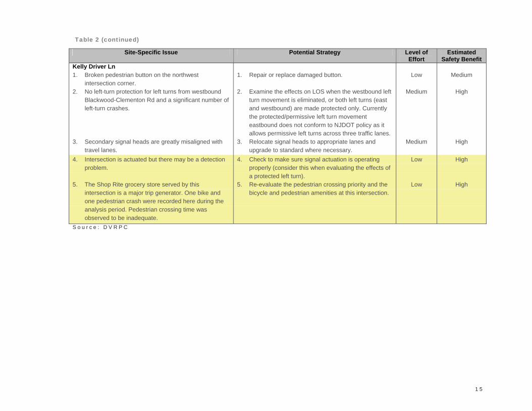
Safety Benefit Kelly Driver Ln 1. Broken pedestrian button on the northwest
intersection corner. 2. No left-turn protection for left turns from westbound
Blackwood-Clementon Rd and a significant number of left-turn crashes.
3. Secondary signal heads are greatly misaligned with
travel lanes. 4. Intersection is actuated but there may be a detection
problem. 5. The Shop Rite grocery store served by this
intersection is a major trip generator. One bike and one pedestrian crash were recorded here during the analysis period. Pedestrian crossing time was observed to be inadequate.
1. Repair or replace damaged button. 2. Examine the effects on LOS when the westbound left
turn movement is eliminated, or both left turns (east and westbound) are made protected only. Currently the protected/permissive left turn movement eastbound does not conform to NJDOT policy as it allows permissive left turns across three traffic lanes.
3. Relocate signal heads to appropriate lanes and upgrade to standard where necessary.
4. Check to make sure signal actuation is operating properly (consider this when evaluating the effects of a protected left turn).
5. Re-evaluate the pedestrian crossing priority and the bicycle and pedestrian amenities at this intersection.
Low
Medium
Medium
Low
Low
Low
Medium
High
High
High
High
S o u r c e : D V R P C
Table 2 (continued)

1 6

1 7
C H A P T E R 4
Conclusions
The RSA is conducted to generate improvement recommendations and countermeasures for roadway segments or intersections demonstrating a history of, or potential for, motor vehicle crashes. The safety recommendations, identified during the audit and documented in this report, should improve the safety of the study area. Many of the strategies identified can be implemented through routine maintenance. The full impact of the improvement strategies will be realized when they are combined, but time and budget constraints may dictate the implementation schedule.
Engineering strategies alone will not eliminate the traffic safety issues identified along the study corridor. Education, with support from a targeted enforcement campaign, is an effective approach for addressing the driver behaviors that lead to crashes. Policy or legislative actions can provide the legal weight needed to motivate people to be safer, more conscientious drivers. Thus, employing a multi-pronged approach and engaging the appropriate stakeholders will be the most effective course of actions to advance the goal of improved safety on Blackwood-Clementon Road.

1 8

A P P E N D I X A
Audit Team


A – 1
Audit Team
Name Agency E-mail
Anthony O'Toole Camden County Department of Public Works [email protected] Truemen Federal Highway Administration [email protected] Noe Camden County Department of Public Works [email protected] Murphy DVRPC [email protected]. Edward Bryant Gloucester Township Police Department [email protected] Reeve New Jersey Division of Highway Traffic Safety [email protected] Moore DVRPC [email protected] Azam NJDOT Bureau of Safety Programs [email protected] Cosme NJDOT Bureau of Safety Programs [email protected] Neaderland DVRPC [email protected]


A P P E N D I X B
Corridor-wide Data
Study Area Map
Traffic Volume Map
Transit Network
Crash Summary
Crashes by Mile Post
Site Photos


42
534
759
706
673
MILL
BRID
GE R
D
COLLEGE DR
759
DR
673
GLOUCESTER
Lindenwold
Pine Hill
ERIAL RD
LITTLE GLOUCESTER RD
COLLEGE DR
BLACKWOOD - CLEMENTON RD
LAUREL
R
D
STATE ST
COLES RD
KELLY DRIVERS LNPE
TERS
L
N
DAVISTOWN RD
CHERRYWOOD DR
LITTLE MILL RDE CHURCH ST
WOODLANE
ERIAL RD
BROADACRES DR
SPRINGLANE DR
0 400 800Feet
Aerial Imagery: NJOIT, 2007
JUNE 2 00 9
Study AreaGloucester Twp., Camden Co., NJ
CR 534 Blackwood - Clementon Rd. Road Safety Audit
Study Limits (MP 4.35 – 6.25)
B – 1

!42
534
759
706
673
MIL
LBR
IDG
E
RD
CO
LLEG
E D
R
759
DR DR D
R
673
GLOUCESTER
Lindenwold
Pine Hill
ERIAL RD
LITTLE GLO
UC
ESTER R
D
BLACKWOOD - CLEMENTON RD
LAUR
EL
RD
STATE ST
COLES
RD
KELLY D
RIV
ER
S LN
PETE
RS
L
N
DAVISTOWN RD
CH
ER
RY
WO
OD
LITTLE MILL RD
E CHURCH ST
WOODLANE
ERIAL RD
BROADACRES
SPRIN
GLAN
E DR
200913,811 WB
200914,636 WB
200910,714 EB
200422,423 Both*
200914,463 EB
200425,161 Both*
Annual Average Daily Traffic VolumesGloucester Twp., Camden Co., NJ
CR 534 Blackwood - Clementon Rd. Road Safety Audit
0 400 800
Feet
±
JUNE 2009
* NJDOT Count
Study Limits (MP 4.35 – 6.25)
Traffic Count Location (approximate)
B – 2
42
534
759
706
673759
DR DR
673
ERIAL RD
LITTLE GLOUCESTER RD
BLACKWOOD - CLEMENTON RD
LAUR
EL
RDSTATE ST
COLES RD
KELLY DRIVERS LNPE
TERS
L
N
DAVISTOWN RD
CHERRYWOODLITTLE MILL RD
E CHURCH ST
WOODLANE
ERIAL RD
BROADACRES
SPRINGLANE DR
MILL
BRID
GE R
D
COLLEGE DR
DR
GLOUCESTER
Lindenwold
Pine Hill
459
400
459400
459
4000 400 800
Feet
JUNE 2009
Transit NetworkGloucester Twp., Camden Co., NJ
CR 534 Blackwood - Clementon Rd. Road Safety Audit
Source: NJ Transit - 2007
Study Limits (MP 4.35 – 6.25)
NJ Transit Bus Routes:
Bus Stop
(Sicklerville - Philadelphia)400459 (Voorhees Town Center - Camden County College -
Avandale Park & Ride)
B – 3

CRASH SUMMARY
County Route 534 MP 4.35 - 6.25Gloucester Township and Lindenwold - Pine Hill Boroughs, Camden County
01/01/2005 THRU 12/31/2007
TOTAL CRASHES: 428
SEVERITY COUNT % OF TOTAL 2007 Average INTERSECTION COUNT % OF TOTAL 2007 Average **Fatal 1 0.23% At Signalized Intersection 122 28.50% 14.74%Injury 145 33.88% 28.29% At Unsignalized Intersection 76 17.76%Property Damage 282 65.89% Between Intersections 230 53.74% FTotal 428 Railroad Crossing 0 0.00%
Total 428
COLLISION TYPE COUNT % OF TOTAL 2007 Average ** SURFACE CONDITION COUNT % OF TOTAL 2007 Average **Same Dir.-Rear End 173 40.42% 30.63% Dry 326 76.17% 75.43% FSame Dir.-Sideswipe 47 10.98% Wet Surface 91 21.26% 19.00%Angle 96 22.43% 19.58% Snow 10 2.34% 2.10%Head On 1 0.23% Ice 1 0.23%Parked Vehicle 1 0.23% Unknown 0 0.00%Left Turn / U Turn 64 14.95% 5.66% Other 0 0.00%Backing 5 1.17% Total 428Encroachment 2 0.47% 0.41%Overturned 1 0.23% LIGHT COUNT % OF TOTAL 2007 Average **Fixed Object 17 3.97% Day 291 67.99%Animal 1 0.23% Dusk 19 4.44% 2.60%Pedestrian 7 1.64% F Night 115 26.87% 24.80% FPedalcycle 5 1.17% 0.96% Dawn 2 0.47%Non-Fixed Object 6 1.40% 0.41% Unknown 1 0.23%Unknown 1 0.23% 0.09% Total 428Other 1 0.23%Total 428
Note:
Length of Segment 1.9 miles Number of Years 3** These columns indicate the number of fatal crashes in each accident category. Source: DVRPC, NJDOT
The 2007 average reflects all crashes recorded on the county route system during that year. It is standard practice to use only the most recent year of statewide data when making a comparison since yearly fluctuations regarding system-wide data are typically insignificant.
B – 4

BLACKWOOD - CLEMENTON RD
ERIAL RD
PETE
RS
LN
LITTLE GLOUCESTER RD
CHER
RYW
OOD
DR
COLLEGE D
R
MILL
BRID
GE R
D
KELLY DRIVERS LN
LAUREL
RD
SPRINGLANE DR
WOODLANE
DR
42
706 759
534
673
673
Study Limits (MP 4.35 – 6.25)
Aerial Imagery: NJOIT, 2007
JUNE 2 00 9
0 250 500Feet
Crashes by Mile Post: 2005 - 2007Gloucester Twp., Camden Co., NJ
CR 534 Blackwood - Clementon Rd. Road Safety Audit
1 13
14
39
31 0 1
13
0 1 1 0 1 0 1 2
18
2 1 0 0 0 1 02
11
4 42 2 1 1 0 1 0 0 0 0 1 0 0 0 0
20 0 0 0 1 0 0 1 0 0 0 1 0 0 0 0 0 0 0
20 0 0 0 0 0
25
1 03
7
21
2 30 1 0 1 0 0 0
30 0 1 0 0 0 0 0 0 0 0 0 0 1
30 1
36
13
0 1 0 0 0 0 1 1 0 02 1 1 0
2 1 20
30
32
7
0 0 0 1 03 2
18
2 31 1 0 0 0 0 0 0 0 0 1 1 0 0 1 0
20
40 0 0
62
41
2 3 2 1 0 0 1 14
14
9
34
5 41
3 25
0 13
005
1015202530354045
4.35
4.38
4.41
4.44
4.47
4.50
4.53
4.56
4.59
4.62
4.65
4.68
4.71
4.74
4.77
4.80
4.83
4.86
4.89
4.92
4.95
4.98
5.01
5.04
5.07
5.10
5.13
5.16
5.19
5.22
5.25
5.28
5.31
5.34
5.37
5.40
5.43
5.46
5.49
5.52
5.55
5.58
5.61
5.64
5.67
5.70
5.73
5.76
5.79
5.82
5.85
5.88
5.91
5.94
5.97
6.00
6.03
6.06
6.09
6.12
6.15
6.18
6.21
6.24
Cras
hes
Mile Post
B – 5

Cross Section Geometry
B – 6

Signals
B – 7

Pedestrian Environment
B – 8

Bicyclist Environment
B – 9

Visibility
B – 10

Driveways
B – 11

1-A

A P P E N D I X C
CR 534 (Blackwood-Clementon Road) in the Vicinity of Erial Road (east and west) and NJ 42 Interchange
Location-Specific Data
Aerial Map with Crashes
Crash Summary
Turning Movement Counts
Site Photos


Road Safety Audit
CR 534 vicinity ofErial Road (east and west)
and NJ 42 interchange
Reportable CrashesCollision Diagram
Crash Data Years 2005 – 2007
Mile Post 4.54 – 4.55: Erial Rd CR 706 (east)Total Crashes = 20
Rear End (eastbound) – 3Rear End (westbound) – 4Rear End (southbound) – 1Right Angle – 4Left /U Turn – 2Same Dir Sideswipe – 2Bicycle – 1Hit Fixed Object – 1Unknown – 1
Mile Post 4.41 - 4.53:Vicinity of the NJ 42 Interchange between Erial Rd east and westTotal Crashes = 24
Rear End (southbound) – 6Rear End (eastbound) – 5Rear End (westbound) – 1Rear End (northbound) – 1Left /U Turn – 7Bicycle – 1Hit Fixed Object – 1Right Angle – 1Same Dir Sideswipe – 1
Mile Post 4.40: CR 706 Erial Rd (west)Total Crashes = 39
Right Angle (west/south) – 12Right Angle (other) – 7Rear End (eastbound) – 5Rear End (westbound) – 4Left /U Turn – 2Backing – 2Hit Fixed Object – 2Hit Non-fixed Object – 1Overturned Vehicle – 2Unknown – 1
Total Crashes = 83Total Bicycle Crashes = 2
*Note: Collision type totals may differ from summary due to adjustments made after review of crash details.
SCHEMATIC NOT TO SCALE
C – 1

Road Safety AuditCR 534 Blackwood Clementon Rd
CR 706 Erial Rd and NJ 42 Interchange AreaMP 4.40 - 4.55Crash Years: 2005 - 2007
Category Total % of TotalSame Direction (Rear End) 30 36.1%Same Direction (Side Swipe) 5 6.0%Right Angle 27 32.5%Opposite Direction 0.0%Struck Parked Vehicle 0.0%Left Turn/U Turn 11 13.3%Backing 2 2.4%Encroachment 0.0%Overturned 1 1.2%Fixed Object 4 4.8%Animal 0.0%Pedestrian 0.0%Pedalcyclist 2 2.4%Non-fixed Object 1 1.2%Railcar - Vehicle 0.0%Unknown 0.0%Other 0.0%
83 100.0%At Intersection 60 72.3%Not at Intersection 23 27.7%At or Near Railroad Crossing 0.0%
83 100.0%Day 61 73.5%Dusk 5 6.0%Night 17 20.5%Dawn 0.0%Other/Unknown 0.0%
83 100.0%Fatality 0.0%Injury 25 30.1%Property 58 69.9%
83 100.0%Dry 67 80.7%Wet 15 18.1%Snowy 1 1.2%Icy 0.0%Other
83 100.0%
*Note: Collision type totals may differ from diagram due to adjustments made after review of crash details.
C – 2
SCHEMATIC NOT TO SCALE
Peak Hour Turning Movement Counts Peak HoursAM: 7:15 - 8:15PM: [6:00 - 7:00]May 2009
CR 534 BLACKWOOD-CLEMENTON RD
CR 706 ERIAL RD
0 [9] 480 [641] 14 [35]
4 [20] 278 [927] 188 [439]
2 [7]
2 [0]
13 [7]
17 [40]
3 [10]
357 [469]
C – 3

Vicinity of Erial Road (east and west) and NJ 42 Interchange
C – 4

Vicinity of Erial Road (east and west) and NJ 42 Interchange
C – 5

A P P E N D I X D
CR 534 (Blackwood-Clementon Road) at CR 759 (Little Gloucester Road)
Location-Specific Data
Aerial Map
Collision Diagram
Crash Summary
Turning Movement Counts
Site Photos


COLLISION TYPERear-end 16Left Turn / U Turn 9Right Angle 5Sideswipe 5Hit Pedestrian 1
Total 36INTERSECTIONAt Intersection 18Not at Intersection 18Total 36
2. CR 534 Blackwood-Clementon Rd at CR 759 Little Gloucester Rd Mile Post 5.12 – 5.16
D – 1

Total Crashes = 36
Legend
Rear End
Angle
= # Crashes1
Left Turn / U-Turn
Road Safety Audit
CR 534 and CR 759 Little Gloucester Rd
Intersection
Reportable CrashesCollision Diagram
Crash Data Years 2005 – 2007
2
1
1
5
1
3
1
2
2
1
6
21
2
1
1
2
1
Sideswipe
Pedestrian Crashes = 1
Hit Pedestrian
CR
759 Little Gloucester R
d
CR 534 Blackwood-Clementon Rd
SCHEMATIC NOT TO SCALE
1
D – 2

Road Safety AuditCR 534 Blackwood Clementon Rd
CR 759 Little Gloucester RdMP 5.12 - 5.16Crash Years: 2005 - 2007
Category Total % of TotalSame Direction (Rear End) 16 44.4%Same Direction (Side Swipe) 4 11.1%Right Angle 5 13.9%Opposite Direction 1 2.8%Struck Parked Vehicle 0.0%Left Turn/U Turn 9 25.0%Backing 0.0%Encroachment 0.0%Overturned 0.0%Fixed Object 0.0%Animal 0.0%Pedestrian 1 2.8%Pedalcyclist 0.0%Non-fixed Object 0.0%Railcar - Vehicle 0.0%Unknown 0.0%Other 0.0%
36 100.0%At Intersection 18 50.0%Not at Intersection 18 50.0%At or Near Railroad Crossing 0.0%
36 100.0%Day 28 77.8%Dusk 0.0%Night 8 22.2%Dawn 0.0%Other/Unknown 0.0%
36 100.0%Fatality 0.0%Injury 11 30.6%Property 25 69.4%
36 100.0%Dry 27 75.0%Wet 6 16.7%Snowy 3 8.3%Icy 0.0%Other
36 100.0%
D – 3

SCHEMATIC NOT TO SCALE
Peak Hour Turning Movement Counts Peak HoursAM: 8:00 - 9:00PM: [4:45 - 5:45]May 2009
CR 534 BLACKWOOD-CLEMENTON RD
CR
759
LI T
TLE
GLO
UC
ESTE
R R
D
136
[2
16]
31
5
[338
]
131
[1
00]
41 [63] 517 [809]
46 [80]
30
[62]
282
[44
7]
7
3 [
206]
34 [97] 510 [951] 49 [85]
D – 4

At CR 759 (Little Gloucester Road)
D – 5


A P P E N D I X E
CR 534 (Blackwood-Clementon Road) from Cherrywood Drive to Millbridge Road
Location-Specific Data
Aerial Map
Collision Diagram
Crash Summary
Turning Movement Counts
Site Photos


COLLISION TYPERear-end 37Left Turn / U Turn 12Sideswipe (same dir) 6Hit Fixed Object 4Right Angle 2Bicycle 2Hit Pedestrian 1Opp Dir Sideswipe 1Total 65INTERSECTIONAt Intersection 33Not at Intersection 32Total 65
3. CR 534 Blackwood-Clementon Rd from Cherrywood Dr to Millbridge Rd Mile Post 5.66 – 5.76
E – 1

Total Crashes = 65
Hit Fixed Object
Rear End
Angle
= # Crashes1
Road Safety Audit
CR 534 from Cherrywood Drive to Millbridge Rd
Intersections and Vicinity
Reportable CrashesCollision Diagram
Crash Data Years 2005 – 2007
1
1
2
1
Total Bicycle Crashes = 2Total Pedestrian Crashes = 1
Left Turn / U Turn
Same Dir Sideswipe
Opp Dir Sideswipe
Legend
Hit Pedestrian
Pedalcyclist
1
2
6
31
1
1
1
4
3
1
1 2
1
1
3
1
1
1
1
2
7
1
14
Cherryw
ood Drive
CR 534 Blackwood-Clementon Rd
Millbridge R
d
SCHEMATIC NOT TO SCALE
8
1
E – 2

Road Safety AuditCR 534 Blackwood Clementon Rd
Cherrywood Dr to Millbridge RdMP 5.66 - 5.76Crash Years: 2005 - 2007
Category Total % of TotalSame Direction (Rear End) 37 56.9%Same Direction (Side Swipe) 6 9.2%Right Angle 2 3.1%Opposite Direction 1 1.5%Struck Parked Vehicle 0.0%Left Turn/U Turn 12 18.5%Backing 0.0%Encroachment 0.0%Overturned 0.0%Fixed Object 4 6.2%Animal 0.0%Pedestrian 1 1.5%Pedalcyclist 2 3.1%Non-fixed Object 0.0%Railcar - Vehicle 0.0%Unknown 0.0%Other 0.0%
65 100.0%At Intersection 33 50.8%Not at Intersection 32 49.2%At or Near Railroad Crossing 0.0%
65 100.0%Day 51 78.5%Dusk 2 3.1%Night 12 18.5%Dawn 0.0%Other/Unknown 0.0%
65 100.0%Fatality 0.0%Injury 26 40.0%Property 39 60.0%
65 100.0%Dry 48 73.8%Wet 14 21.5%Snowy 2 3.1%Icy 1 1.5%Other
65 100.0%
E – 3

SCHEMATIC NOT TO SCALE
Peak Hour Turning Movement Counts Peak HoursAM: 7:45 - 8:45PM: [4:45 - 5:45]May 2009
CR 534 BLACKWOOD-CLEMENTON RD
CH
ERR
YWO
OD
DR
86
[72]
0
[0]
77
[7
8]
0 [0] 729 [823] 68 [112]
0 [0] 445 [872] 24 [62]
E – 4

From Cherrywood Drive to Millbridge Road
E – 5


A P P E N D I X F
CR 534 (Blackwood-Clementon Road) at Kelly Driver Lane
Location-Specific Data
Aerial Map
Collision Diagram
Crash Summary
Turning Movement Counts
Site Photos


COLLISION TYPERear-end 20Right Angle 14Left Turn / U Turn 11Sideswipe (same dir) 4Hit Non-fixed Object 1Hit Fixed Object 1Hit Pedestrian 1Bicycle 1Encroachment 1Total 54INTERSECTIONAt Intersection 34Not at Intersection 20Total 54
4. CR 534 Blackwood-Clementon Rd at Kelly Driver Ln Mile Post 6.0 – 6.04
F – 1

Total Crashes = 54Pedestrian Crashes = 1Bicycle Crashes = 1
2
Road Safety Audit
CR 534 and Kelly Driver Ln
Intersection
Reportable CrashesCollision Diagram
Crash Data Years 2005 – 2007
SCHEMATIC NOT TO SCALE
Kelly Driver Ln
3
1
Hit Fixed Object
Rear End
Angle
= # Crashes1
Left Turn / U Turn
Same Dir Sideswipe
Legend
Hit Non-Fixed Object
Encroachment
1
1
2 7
3
1
52
3
1
5
5
1
1
E 1
2
1
1
E
1
1
1
1
1
Hit Pedestrian
Pedalcyclist
CR 534 Blackwood-Clementon Rd
F– 2

Road Safety AuditCR 534 Blackwood Clementon Rd
Kelly Driver LnMP 6.0 - 6.04Crash Years: 2005 - 2007
Category Total % of TotalSame Direction (Rear End) 20 37.0%Same Direction (Side Swipe) 4 7.4%Right Angle 14 25.9%Opposite Direction 0.0%Struck Parked Vehicle 0.0%Left Turn/U Turn 11 20.4%Backing 0.0%Encroachment 1 1.9%Overturned 0.0%Fixed Object 0.0%Animal 0.0%Pedestrian 1 1.9%Pedalcyclist 1 1.9%Non-fixed Object 1 1.9%Railcar - Vehicle 0.0%Unknown 0.0%Other 1 1.9%
54 100.0%At Intersection 34 63.0%Not at Intersection 20 37.0%At or Near Railroad Crossing 0.0%
54 100.0%Day 28 51.9%Dusk 4 7.4%Night 22 40.7%Dawn 0.0%Other/Unknown 0.0%
54 100.0%Fatality 0.0%Injury 23 42.6%Property 31 57.4%
54 100.0%Dry 44 81.5%Wet 10 18.5%Snowy 0.0%Icy 0.0%Other
54 100.0%
F – 3

SCHEMATIC NOT TO SCALE
Peak Hour Turning Movement Counts Peak HoursAM: 8:00 - 9:00PM: [6:00 - 7:00]May 2009
CR 534 BLACKWOOD-CLEMENTON RD
KELL
Y D
RIV
ER L
N
34
[81]
20
[30]
16
[63]
87 [110] 613 [835] 8 [22]
64
[9
1]
2
2
[33]
143
[1
79]
43 [83]
492 [815] 33 [90]
F – 4

At Kelly Driver Lane
F – 5


A P P E N D I X G
CR 534 (Blackwood-Clementon Road) at CR 673 (Laurel Avenue / College Drive)
Location-Specific Data
Aerial Map
Collision Diagram
Crash Summary
Site Photos


COLLISION TYPERight Angle 20Sideswipe 12Rear-end 9Left Turn / U Turn 6Backing 2Hit Fixed Object 1Hit Non-fixed Object 1Total 51INTERSECTIONAt Intersection 26Not at Intersection 25Total 51
5. CR 534 Blackwood-Clementon Rd at CR 673 Laurel Ave / College Dr Mile Post 6.13 – 6.17
G – 1

Total Crashes = 51
Hit Fixed Object
Rear End
Angle
= # Crashes1
Road Safety Audit
CR 534 and CR 673 Laurel Ave / College Dr
Intersection
Reportable CrashesCollision Diagram
Crash Data Years 2005 – 2007
Left Turn / U Turn
Same Dir Sideswipe
Opp Dir Sideswipe
Legend
SCHEMATIC NOT TO SCALE
CR 6
73 L
aure
l Ave
CR 6
73 C
olleg
e Rd
CR 534 Blackwood-Clementon Rd
(former) Little Mill Rd intersection
1
1
Hit Non-Fixed Object
3
4
1
2
Backing
2
2
21
2
1
2
1
3
1
5
3
1
1
2
2
2
1
1
1 1 11
G – 2
Road Safety AuditCR 534 Blackwood Clementon Rd
CR 673 Laurel Ave / College DrMP 6.13 - 6.17Crash Years: 2005 - 2007
Category Total % of TotalSame Direction (Rear End) 9 17.6%Same Direction (Side Swipe) 12 23.5%Right Angle 20 39.2%Opposite Direction 0.0%Struck Parked Vehicle 0.0%Left Turn/U Turn 6 11.8%Backing 2 3.9%Encroachment 0.0%Overturned 0.0%Fixed Object 1 2.0%Animal 0.0%Pedestrian 0.0%Pedalcyclist 0.0%Non-fixed Object 1 2.0%Railcar - Vehicle 0.0%Unknown 0.0%Other 0.0%
51 100.0%At Intersection 26 51.0%Not at Intersection 25 49.0%At or Near Railroad Crossing 0.0%
51 100.0%Day 30 58.8%Dusk 1 2.0%Night 19 37.3%Dawn 1 2.0%Other/Unknown 0.0%
51 100.0%Fatality 0.0%Injury 13 25.5%Property 38 74.5%
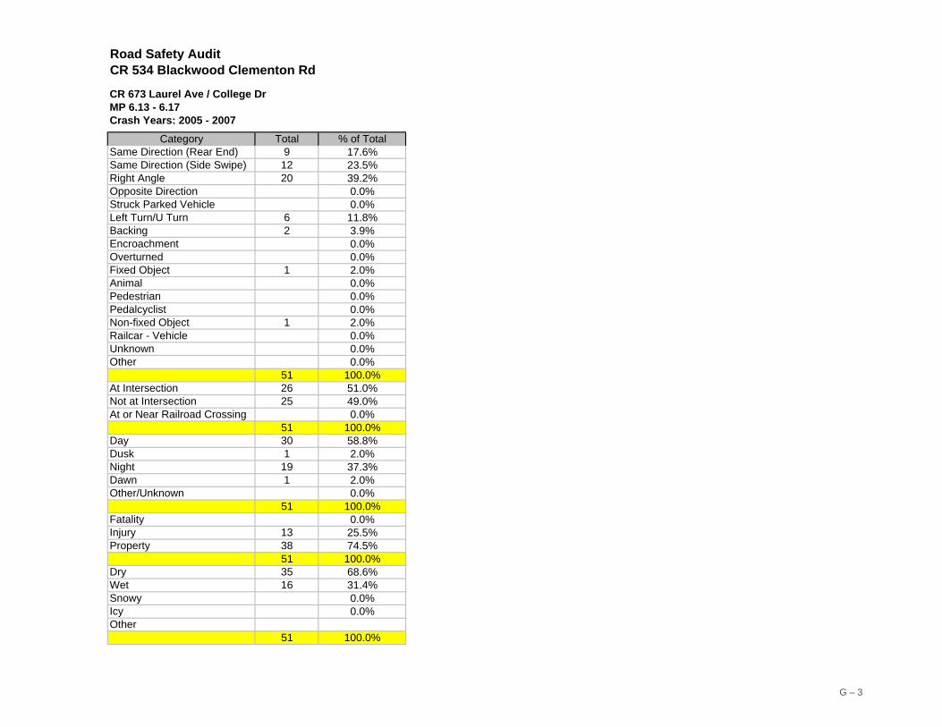
51 100.0%Dry 35 68.6%Wet 16 31.4%Snowy 0.0%Icy 0.0%Other
51 100.0%
G – 3

At CR 673 (Laurel Avenue / College Drive)
G – 4

Publication Title: CR 534 (Blackwood-Clementon Road) Road Safety Audit
Publication Number: 09022
Date Published: January 2010
Geographic Area Covered: Gloucester Township, Camden County, New Jersey
Road safety audit, RSA, crashes, injuries, fatalities, issues, strategies, traffic signal, coordination, engineering, enforcement, education, stakeholders, prioritize, intersection, speed limit, traffic volumes, stakeholders, audit team, geometry, pavement markings, signs, crosswalk, sidewalk, curb ramp, two-way-left-turn-lane, CR 534, Blackwood-Clementon Road
This report documents the process and findings of the CR 534 (Blackwood-Clementon Road) Road Safety Audit (RSA) undertaken by the Delaware Valley Regional Planning Commission (DVRPC). The report details safety issues identified by the audit team at the study location and remedial strategies to address them. The goal of the audit is to generate improvement recommendations and countermeasures for the study area in an effort to reduce the incidence of motor vehicle crashes. Emphasis is placed on identifying low-cost, quick turnaround safety projects to address the identified issues where possible. This project represents a step towards implementation of DVRPC’s Regional Safety Action Plan. Implementation of improvement strategies may be eligible for Local Federal Safety Funds.
Kevin S. Murphy Principal Planner, Transportation Safety and Congestion Management ℡ (215) 238-2864
Delaware Valley Regional Planning Commission 190 N. Independence Mall West, 8th Floor Philadelphia PA 19106 Phone: (215) 592-1800 Fax: (215) 592-9125 Internet: www.dvrpc.org
Key Words:
Abstract:
Staff Contact: