84
.I CRAIG FLOWER WATERSHED MANAGEMENT PLAN August 1998 Developed by

.I
CRAIG FLOWER WATERSHED MANAGEMENT PLAN
August 1998
Developed by

CRAIG FLOWER WATERSHED MANAGEMENT PLAN SUMMARY
The Craigflower Watershed is located in the Capital Regional District (CRD), extending from Mount Work in the District of Highlands south to Portage Inlet in the Town of View Royal. As part of a Watershed Management Strategy endorsed by the CRD Environment Committee, the Craigflower Watershed Management Forum was created to develop the Craigflower Watershed Management Plan. The Forum consisted of26 members, including landowners, representatives from nongovernmental organizations, and local and senior government staff.
The Forum identified hydrologically, ecologically, and socially important components of the watershed and prepared a Management Plan to protect them. The Management Plan takes a coordinated approach, seeking to ensure that activities in one jurisdiction do not negatively affect other jurisdictions, and that resources (e.g., fish habitat) do not suffer from other resource uses (e.g., urban development).
The Forum developed the following vision for the Craigflower Watershed:
"The Craigflower Watershed will be maintained and enhanced to provide a healthy environment for human and natural communities in perpetuity."
The vision is supported by more detailed principles for implementing the vision (page 15). The Forum also developed the following six goals for watershed management:
Goal I: Residents and the general public will understand and support stewardship of the watershed.
Goa12: Municipalities, the CRD, and provincial and federal governments will develop and use regulatory and management tools to improve the health of the watershed.
Goal3: Water flows will be managed to protect groundwater recharge, enhance low summer flows, and minimize flooding.
Goal4: Water quality will be improved and maintained.
Goal 5: Riparian and aquatic ecosystems will support healthy populations of fish (anadromous and resident) and wildlife.
Goal6: Native vegetation will be protected and restored throughout the watershed, providing habitat for birds, wildlife, and fish.
The Forum developed a Work Plan for meeting these goals (page 18 onwards), including 17 objectives and 53 specific actions. To facilitate implementation, the Plan identifies a lead agency and contact person, support agencies, resources needed to undertake each action, timing of when the action should occur, and potential sources of funding and other resources. The Plan

categorizes the actions into Existing Actions (8 actions), Program Amendments (12 actions), New Actions (21 actions), and Actions that Need a Lead Agency (12 actions). Actions that Need a Lead Agency are important for meeting the goals of the Plan, but lack an agency for implementing them. These actions could be implemented if a lead agency can be found. The Plan also includes a schedule and budget for Plan implementation (pages 42 to 49).
The Forum acknowledges that some actions are more crucial than others to attaining the Plan's vision. Through a priority-setting exercise, the Forum identified the following top ten priority actions:
I. Contact landowners directly to discuss stewardship of the watershed. 1
2. Amend existing bylaws to protect wetlands from clearing, draining, and development.
3. Change zoning bylaws and Official Community Plans to protect the variable riparian zone defined by mapping of the fisheries sensitive zone.2
4. Enhance and restore fish habitat. 5. Modify Stormwater Management Bylaws. 6. Produce a digital cadastral layer to overlay on the fisheries sensitive zone
map. 7. Amend tree-cutting bylaws to prevent tree-cutting and other vegetation
removal in the identified riparian zone. 8. Prepare a feasibility study of storing more water in the watershed. 9. Review Official Community Plans and other bylaws to ensure consistency
with the Craigflower Watershed Management Plan. I 0. Continue on-going stock assessment at the Craigflower fish fence.
The Plan identifies lead agencies for all actions except for Action 8 - prepare a feasibility study of storing more water in the watershed. A lead agency is needed if this action is to be implemented.
The Forum was established to develop the Plan. Having completed the Plan, the Forum is now dissolved. Implementation of Plan actions will be the responsibility of the lead agencies identified in the Plan. The Forum recommends that a Craigflower Watershed Management Steering Committee be struck to replace the Forum and coordinate Plan implementation. The Steering Committee will include representatives from two municipalities, CRD Parks, and three non-governmental organizations.
1 This action must be preceded by another action, "Gather, adapt, and distribute pamphlets about management of the watershed."
2 This action must be preceded by another action, "Map fisheries sensitive zone and provide maps of the fisheries sensitive zone to municipalities."
11

Craigflower Watershed Management Plan
CONTENTS
Summary ....................................................................................................................................... i Acknowledgements ........................................................................................................................ v Abbreviations ................................................................................................................................. vi
1.0 INTRODUCTION .............................................................................................................. I 1.1 Introduction to the Craigflower Watershed ............................................................ 2 1.2 Watershed Management ......................................................................................... 5 1.3 CRD Watershed Management Strategy ................................................................... 5 1.4 On-going Work in the Watershed ........................................................................... 7
2.0 CRAIG FLOWER WATERSHED MANAGEMENT PLANNING PROCESS ................ 9 2.1 Craigflower Watershed Management Forum ........................................................ 9 2.2 Work of the Craigflower Watershed Management Forum ..................................... II
3.0 WATERSHED MANAGEMENT PLAN ...................................................................... 13 3.1 Vision for the Craigflower Watershed ................................................................... 15 3.2 Goals and Objectives .............................................................................................. 16 3.3 Work Plan ............................................................................................................... 18
3.3.1 Top Ten Priority Actions ............................................................................ 18 3.3.2 Detailed Work Plan .................................................................................... 18
3.4 Timeline .................................................................................................................. 42 3.5 Budget Summary .................................................................................................... 47 3.6 Implementation .................................................................................................... 50
4.0 REFERENCES ................................................................................................................... 53
APPENDIX A
Options for Watershed Management from The Craigflower Watershed Assessment ........ 55
APPENDIXB P .. S . E . nonty- ettmg xerc1se .................................................................................................... 57
APPENDIXC Status Report Sheet ............................................................................................................ 71
APPENDIXD Suggested Indicators for use in preparing Health of the Watershed Summary Reports .... 73
Craigjlower Watershed Management Plan Page iii

LIST OF TABLES
Members of the Craigflower Watershed Management Forum and their affiliations ............................................................................................................. 9
2 Timeline for implementation of new actions and program amendments for the Craigflower Watershed Management Plan ......................................................... 43
3. Budget summary for the Craigflower Watershed Management Plan ................. 48
LIST OF FIGURES
Jurisdictions in the Craigflower Watershed ......................................................... 3
2 The Craigflower Watershed Management Plan .................................................. 13
,_
Page iv Craigjlower Watershed Management Plan

ACKNOWLEDGEMENTS
This report was prepared by Julia Roberts, Robyn Wark, and David Harper of Westland Resource Group. Westland would like to thank Rob Miller of CRD Environmental Services Group for his work in coordinating this project and promoting watershed management in the
region. We would also like to thank the members of the Craigflower Watershed Management Forum for the time, energy, enthusiasm, and expertise that they contributed to developing this
plan. The Forum members were:
Barbara A very
Richard Bickel
Bruno Blecic
Ted Burns
Kim Carpenter
Marlene Caskey
Craig Davidson
Tony Embleton
Cindy Harlow
Karen Hurley (Jana Kotaska
alternate)
Ben Kangasniemi (Ted White, alternate)
Kevin Key
Peter Law
Town of View Royal. Planning
View Royal Environment Commission
MELP, Water Management,
Victoria District Office
Community Fisheries
Development
District of Highlands, Stewardship
Coordinator.
MELP, Fish and Wildlife, Vancouver Island Region
Community Fisheries
Development
Victoria Natural History Society
Depa11ment of Fisheries and Oceans
District of Saanich, Environmental Planning
MELP, Water Quality, Victoria
District of Highlands, Planning
MELP. Fish and Wildlife, Vancouver Island Region
Joyce Lee
Rick Lloyd
Peter McCully
Mike Meagher (Elizabeth MacMillan,
alternate)
Rob Miller
Dave Morris
Tom Plasterer
John Roc
(Brian Killeen, alternate)
Tom Rutherford
Dan Saari
Jack Stidston
Michael Todd
Joel Ussery
View Royal Natural Habitat Action Group
District of Saanich, Engineering Department
Goldstream Volunteer Salmonid Enhancement Association
Thetis Park Nature Sanctuary Association
CRD Environmental Services Group
Provincial Capital Commission
No Affiliation, Private Landowner
Veins of Life Watershed Society
Department of Fisheries and Oceans
Ministry of Transportation and Highways
Portage Inlet Enhancement Society
No Affiliation, Private Landowner
CRD Parks Department
The work of the Forum was based on an assessment of the Craigflower Watershed (SHIP, 1997) prepared by Julia Roberts and Ted Harding of SHIP Environmental Consultants Ltd.
Craigflower Watershed Management Plan Pagev


ABBREVIATIONS
BMPs CDC CFDC- SIS
CRDESG CRD Parks CRDRPS
DFO Env. Canada ESAs ESRs Fish Renewal BC
FFL GBI GVSEA HCF HREF MAFF MELP MELP-F&W MELP-Water Qlty MELP-Water Mgmt MMA MoF MoTH NGOs OCP PAHs PCC PIES
PSF PSFed
RIC RNSP RRU
SEI TPNSA VIHP VNHS VOLWS VRNHAG
Page vi
Best Management Practices Conservation Data Centre Community Fisheries Development Centre - South Island Streams Capital Regional District Environmental Services Group Capital Regional District Parks Department Capital Regional District Regional Planning Services Department of Fisheries and Oceans Environment Canada Environmentally Sensitive Areas Environmental and Social Reviews Fisheries Renewal BC Friends of Fork Lake Georgia Basin Initiative
Goldstream Volunteer Salmonid Enhancement Association Habitat Conservation Fund Habitat Restoration and Enhancement Fund, DFO Ministry of Agriculture, Fisheries and Food Ministry of Environment, Lands and Parks Ministry of Environment, Lands and Parks- Fish and Wildlife Ministry of Environment, Lands and Parks- Water Quality Ministry of Environment, Lands and Parks- Water Management Ministry of Municipal Affairs Ministry of Fisheries Ministry of Transportation and Highways Non-governmental organizations (e.g. community groups) Official Community Plan Polycyclic Aromatic Hydrocarbons (petroleum byproducts) Provincial Capital Commission Portage Inlet Enhancement Society
Pacific Salmon Foundation Pacific Streamkeepers Federation
Resource Inventory Committee
Restoration of Natural Systems Program, University of Victoria Royal Roads University Sensitive Ecosystems Inventory Thetis Park Nature Sanctuary Association Vancouver Island Highway Project Victoria Natural History Society Veins of Life Watershed Society
View Royal Natural Habitat Action Group
Craigflower Watershed Management Plan


1.0 INTRODUCTION
The Craigflower Watershed serves many important functions in the Capital Region. Craigflower Creek and its tributary lakes and streams support a variety of fish species (including coho salmon and cutthroat trout) and other wildlife. The aesthetic values of greenspace in the watershed are enjoyed by residents and visitors alike. The watershed supports exceptional recreational opportunities at Thetis Lake Park (one of region's busiest parks), Mount Work Park, and on private land. Because the upper reaches of the watershed are still relatively
undeveloped, the hydrologic function of much of the Craigflower system is largely intact, so that groundwater recharge, flood regimes, and other ecological functions mostly reflect natural
patterns.
The Craigflower Watershed is facing strong urban growth pressures, and protecting its values will require concerted action by residents and governments. The lower reaches of Craigflower Creek have already been altered by residential, commercial, and highways development. Controlling land use and runoff in ways that prevent damage to the stream and its ecosystem are important goals of watershed management.
A group of residents, nongovernmental organizations, and local and senior governments have come together as the Craigflower Watershed Forum to identify ecologically and socially important components of the watershed and to prepare a management plan to protect them. The Forum was convened by the Capital Regional District, which also assembled and published this document presenting the Forum's work.
Now that the watershed management plan has been prepared, the real challenges begin-obtaining the commitment, funding and dedication of effort needed to implement the plan, and to achieve the Forum's vision of a watershed that can accommodate human use while protecting its natural values.
Craigjlower Watershed Management Pian Page I

1.1 Introduction to the Craigflower Watershed
The Craigflower Watershed is located in the heart of the Capital Regional District (CRD) on the southern tip of Vancouver Island. From its upper reaches in the District ofHighlands (including Mount Work at 449 m), the watershed drains many scenic hills and valleys as it descends through the Town of View Royal to Portage Inlet. The watershed also includes slivers of land from the Districts of Saanich and Langford (Figure 1).
McKenzie Lake
The Craigflower Watershed contains a complex system of waterways, including streams, lakes, ponds, wetlands, and waterfalls. The best known lakes are Upper and Lower Thetis Lakes, Prior Lake, and McKenzie Lake. These lakes are popular recreation sites in or near Thetis Lake Regional Park. The ponds are mostly on private property and many were created by dredging wetlands or building dams around spnngs.
Nearly 30% of the watershed is protected in regional parks, including Thetis Lake Park, Francis King Park, and Mount Work Park.
Most of the urban development is concentrated in the lower watershed on both sides of the Trans Canada Highway in View Royal. Land uses include residential, commercial, and institutional development. This part of the region is facing urban growth pressures.
The upper parts of the watershed are primarily forested or used for agriculture or residential acreages.
Page 2
Craigflower Creek flows into Portage Inlet
Craigflower Watershed A{anagement Plan
·'

l
Legend
District of
Saanich
I -~S\ ~ \. r \ ~,_,l
il=:S=c=ale=1=:=5o=,o=oo===A~:!.---l._L ~ ~ Figure 1: Jurisdictions in the Craigflower Watershed
Craigflower Watershed Management Plan Page3

·.
The Craigflower Watershed supports habitats for birds, fish, other wildlife, and native vegetation. Species living in the watershed include great blue herons, salamanders, black-tail deer, and at least seven species of bats.
The watershed includes Gany Oak communities, one of the rarest and most endangered ecosystems in Canada.
Craigflower Creek provides spawning and rearing habitat for many fish, including coho salmon.
Volunteers have worked to restore fish stocks in the watershed, and monitor returning coho salmon at a fish counting fence. Low summer water flows, high water temperatures, and contaminated runoff however, threaten fish survival.
One of the many stormwater drains emptying into Craigflower Creek
Page 4
Thetis Park Nature Sanctuar-y, part of Thetis Lake Regional Park
The health of the waterways in the Craigflower Watershed is strongly affected by activities on the land. For example, water quality in the lower reaches of Craigflower Creek can be compromised by urban and agricultural runoff and occasional sewage overflows.
Protecti1tg the health of the Craig/lower Watershed requires good la1td tmd water use practices by all jurisdictio1ts, reside1tts and landowners in the Watershed
The following Craigflower Watershed Management Plan was created by a 26-member Forum of residents, government agencies, and non-governmental organizations working in the watershed. The Plan identifies a vision for the watershed and a work plan to protect and improve watershed health.
Craig/lower Watershed Management Plan
.I

1.2 Watershed Management
A watershed is an area of land that drains precipitation into a river system. Land in a watershed may be used for many different purposes (or functions), including fish and wildlife habitat, human habitation, and human recreation. Activities in one part of a watershed often affect other parts of the watershed. For example, filling a wetland in the upper watershed may increase the
rate of runoff in the lower watershed.
Two key principles of watershed management are:
• Functional Integration - managing one function of the watershed should not harm other functions of the watershed.
• Spatial Integration - management in one part of the watershed should not harm other parts of the watershed.
The benefits of good watershed management include:
• protection of property from flooding and erosion,
• protection of water quality for drinking or swimming,
• financial savings by preventing water quality degradation and flood damage
that are expensive to mitigate,
• protection of natural areas, green space, and habitats for fish and wildlife,
• preservation of aesthetic values that enhance property values, and
• improved recreational opportunities.
A watershed management approach to planning is especially valuable where several municipalities are managing land in a watershed. The watershed planning process provides a
venue for coordinating management and ensuring that activities in one jurisdiction do not have negative impacts in another jurisdiction.
1.3 CRD Watershed Management Strategy
The CRD Environment Committee endorsed a Watershed Management Strategy that includes the creation of Watershed Management Plans. Watershed management is part of the CRD's
ongoing work in storm water quality management.
The CRD has been involved in stormwater quality management since 1983 and was identified
as having a coordinating role for storm water quality management in the 1992 Core Stage 2
Craigjlower Watershed Management Plan Page5

Liquid Waste Management Plan (LWMP). Other components of the CRD stormwater quality program include storm water discharge surveys, public involvement, and promotion of Best
Management Practices (BMPs) to protect stormwater and water courses.
In November 1997, the CRD Environment Committee endorsed a Watershed Management Strategy consisting of the six steps outlined below. (The Craigflower Watershed Management
Plan is part of Step 3.)
Page 6
Step I. Prioritize watersheds in the CRD. Completed for the watersheds in the Core
Liquid Waste Management Plan area (SHIP, 1997).
Step 2. Prepare watershed assessments. Completed for two watersheds, the Millstream Watershed (SHIP, 1996), and the Craigflower Watershed (SHIP, 1997). A draft assessment of part of the Goldstream Watershed was completed by SHIP in late
1997.
The Craigflower Watershed Assessment included mapping the aquatic features of the watershed, assessing the present condition of the watershed, identifying risks to the
natural resources of the watershed, and presenting options for addressing those risks. The assessment recommended that the jurisdictions involved in the watershed jointly develop a watershed management plan. The options for watershed management suggested in the assessment are found in Appendix A.
Step 3. Compile options and develop watershed management plans. Municipal and
CRD staff developed a preliminary Watershed Management Implementation Strategy for the Millstream Watershed (Westland, 1997) that was not distributed to the municipalities. The 26-member Craigflower Watershed Management Forum was created in 1998 to prepare a Watershed Management Plan for the Craigflower Watershed.
Step 4.
Step 5.
Step 6.
Obtain political approval of the plan. To be completed.
Implement the watershed management plan. Some plan actions are already
being implemented by Forum members.
Monitor and report on progress. To be completed.
Craigflower Watershed Management Plan

1.4 On-going Work in the Watershed
Although formal watershed management planning is a new activity for all levels of government and NGOs working in the Craigflower Watershed, several agencies and groups are already adopting policies and completing projects that are beneficial to the watershed.
The Vancouver Island Highway Project (VIHP) has provided improvements to fish habitat and utilized state-of the-art stormwater management techniques. Highway widening required the relocation of a portion of the Craigflower Creek channel.
The "relocation channel," constructed in 1995, was designed to enhance fish habitat. The success of the channel will be monitored for 6 years. Water quality ponds adjacent to the highway collect road runoff and allow sediments to settle out before water drains into Craigflower Creek.
Water quality pond near Vancouver Island Highway with culvert leading to Craigflower Creek
The Highlands Official Community Plan (OCP) adopted in 1997 includes a variety of policies designed to protect aquatic systems. These policies include:
• building and septic tank setbacks of30 m from the high water mark oflakes and streams,
• no draining, dredging, infilling or dumping of materials in water features, • no increase in peak surface runoff from development.
In the summer of 1996, Saanich environmental staff worked with the owners of land on the east bank of lower Craigflower Creek who were making improvements to farm fields. The fields were contoured so that runoff collects in a series of settling pond before finally flowing to the creek. These measures were designed to prevent sediment from being carried into the creek.
Craig/lower Watershed lvfanagement Plan Page 7

In 1996, View Royal required the developers of Riverside Ridge and River Valley s·ubdivisions, adjacent to Craigflower Creek, to install detention ponds that collect runoff from the subdivision. During construction, the ponds acted as settling ponds to reduce the amount of sediment entering the creek. The ponds continue to moderate peak flows from the development to Craigflower
l)etention pond at Riverside Ridge. Craigflower Creek flows through the treed area in the background.
Creek. The Town also designated a 15 m wide park along the creek to protect riparian vegetation and the stream banks.
The Goldstream Volunteer Salmonid Enhancement Association (GVSEA) and the Portage Inlet Enhancement Society (PIES) in cooperation with DFO have been working to improve fish stocks in the watershed. GVSEA releases an average of 15,000 coho fry in each of Pike and Prior Lakes annually. At the fish counting fence near Talcott Road, PIES counts smolts going out to sea and adult salmon returning in the autumn.
These and other similar efforts all contribute to the health of the watershed. The purpose of watershed management planning is to coordinate and expand on these efforts to realize maximum benefit to the watershed.
Watershed management planning in the Craigflower Watershed benefits fi·om other studies and planning processes. The Sensitive Ecosystems Inventory (Environment Canada & I\1ELP, 1997) and the Regional Green/Blue Spaces Strategy (CRD Parks & PCC, 1996) have provided valuable information. The cuJTent review of the View Royal Official Community Plan and the preparation by CRD Parks of a management plan for Thetis Lake and Francis-King Regional Parks provide opportunities to harmonize those plans with the goals of improved watershed health detailed in this plan. Similarly, Highlands' and Saanich's OCPs contain
Fish counting fence on lower Craigflower Creek
policies that may be usefully applied in other jurisdictions.
Page 8 Craigflower Watershed Management Plan
. )
. J

2.0 CRAIG FLOWER WATERSHED MANAGEMENT PLANNING PROCESS
2.1 Craigflower Watershed Management Forum
The CRD's Watershed Management Strategy calls for the creation of a Forum to develop a management plan for each watershed that has been assessed. The strategy states that Forum members should include "engineers and planners from the municipality(s) involved, selected staff from the CRD, MELP, landowners and land users near aquatic features, regulatory agencies, community groups, environmental organizations, and local residents and other
agencies as required"(CRD Engineering Department, 1997). The members of the Craigflower
Watershed Management Forum are listed in Table 1.
Table I. Members of the Craigflower Watershed Management Forum and their affiliations
Name Organization Name Organization
Barbara Town of View Royal, Joyce Lee View Royal Natural Habitat Avery Planning, Action Group
Richard View Royal Environment Rick Lloyd District of Saanich, Engineering Bickel Commission Department
Bruno Blecic MELP, Water Management, Peter Goldstream Volunteer Salmonid Victoria District Office McCully Enhancement Association
Ted Burns Community Fisheries Mike Thetis Park Nature Sanctuary Development Meagher Association
(Elizabeth MacMillan, Alternate)
Kim District of Highlands, Rob Miller CRD Environmental Services Carpenter Stewardship Coordinator Group
Marlene MELP, Fish and Wildlife, Dave Provincial Capital Commission Caskey Vancouver Island Region Morris
Craig Community Fisheries Tom No Affiliation, Private Landowner Davidson Development Plasterer
continued
Craigjlower Watershed Management Plan Page 9

Table 1. continued
Name Organization Name Organization
Tony Victoria Natural History John Roe Veins of Life Watershed
Embleton Society (Brian Society Killeen, alternate)
Cindy Harlow Department of Fisheries and Tom Department of Fisheries and Oceans Rutherford Oceans
Karen Hurley District of Saanich, Dan Saari Ministry of Transportation and (Jan a Environmental Planning Highways Kotaska, alternate)
Ben MELP, Water Quality, Jack Portage Inlet Enhancement Kangasniemi Victoria Stidston Society (Ted White, alternate)
Kevin Key District of Highlands, Michael No Affiliation, Private Landowner Planning, Todd
Peter Law MELP, Fish and Wildlife, Joel Ussery CRD Parks Department Vancouver Island Region
Page 10 Craigflower Watershed Management Plan

1
The CRD Watershed Management Strategy recognizes the importance of including all stakeholders in the planning process. Participation in the Craigflower Watershed Forum by landowners, residents, and community groups as well as staff from all levels of government allowed for a full discussion of diverse interests. By combining the professional expertise, volunteer efforts and funding resources of the participating agencies and organizations, an effective and efficient plan has been developed to improve the health of the watershed.
2.2 Work of the Craigflower Watershed Management Forum
The Forum met for a full-day workshop and field trip on February 27, 1998. The activities of
the day included:
• Discussion of watershed management objectives • Overview of the Craigflower Watershed Assessment • Field trip in the Craigflower Watershed focusing on the following
issues identified in the Craigflower Watershed Assessment Floodplain Management Water Quality Fish Habitat Water Flows Erosion
Riparian Vegetation • Discussion of a vision for the watershed
• Development of a list of key actions for improving the watershed.
The Forum gathered for a second full-day workshop on April 3, 1998. The work undertaken that day consisted of:
• Approval of a short vision statement for the watershed • Discussion of principles to guide implementation of the vision • Development of action plans for the watershed by groups focusing on
Land use and riparian protection
•
Fish and fish habitat Water quality and water storage.
Each group worked from a list of options from the Craigflower Watershed Assessment and a list of suggested actions from Workshop I. Integration of the small group plans to produce a first draft of an
overall watershed management plan.
Craigflower Watershed Management Plan Page II

At a half-day workshop on May 8, 1998, the Forum reviewed the first draft of the Craigflower Watershed Management Plan. The following tasks were completed:
• Discussion of how the plan will be adopted and monitored • Discussion of the overall format and structure of the plan • Review of the Vision Principles • Priority-setting exercise to determine which of the proposed actions
are most important • Review of action responsibilities, budgets, funding sources, and
schedules • Discussion of next steps for the plan and the Forum.
It was agreed at tbe end of the workshop that a second draft of the plan would be distributed to Forum members for review. Forum members were asked to rate the importance of each action for improving conditions in the watershed (See Appendix B). A third draft of the plan was prepared for discussion at the next workshop.
The final half-day workshop was held on June 26, 1998. The main topics of the workshop
were: • Review of the third draft of the Plan • Discussion of the Plan approval process • Discussion of Plan Implementation.
Forum members provided comments on the draft Implementation Section. After revisions, the Implementation Section was incorporated in the Final Plan as Section 3 .6. With the completion of the Plan, the Forum had fulfilled its mandate and was dissolved.
Page 12 Craigflower Watershed Management Plan
3.0 WATERSHED MANAGEMENT PLAN
The Craigflower Watershed Management Plan has six major elements as shown in Figure 2.
Figure 2. The Craigflower Watershed Management Plan
Vision Statement and Principles
Goals
+ Objectives
• ~ Timelines I Actions ~ Responsibilities I
+ '-I Budgets I Implementation
t Monitoring
• Vision Statement and Principles provide overall direction for developing the other sections of the plan.
• Goals state desired outcomes for six major topics of concern identified by the Forum.
• Objectives expand on the Goals by providing a number of desired outcomes that will contribute to achieving each goal.
Craigf/ower Watershed Management Plan Page 13
• Actions are the means by which the Objectives will be met. Each Action is accompanied by a timeline, responsible organization and contact person, and budget.
• Implementation of each action will occur through the many groups and agencies participating in the Forum. Each agency is responsible for obtaining political approval of the Plan, where necessary. Once political approval has been obtained, agencies will be able
to assign staff to the Plan, and seek funding for the actions.
• Monitoring is necessary to ensure that (a) the Plan is implemented and (b) the Forum learns whether the actions are achieving the plan's goals. Is water quality improving? Is Craigflower supporting healthy fish stocks? Is native vegetation and wildlife habitat restored throughout the watershed? If we are not achieving plan goals, the Forum may need to adapt the plan, changing scheduling or altering or adding actions. Monitoring allows agencies to use "adaptive management", a process of learning from the results of
management actions to modifY programs to improve results. Monitoring strategies are therefore built into the implementation section of the Plan.
Page 14 Craigflower Watershed Management Plan
3.1 Vision for the Craigflower Watershed
The Craigflower Watershed Management Forum developed the following vision statement for
the watershed:
Vision for the Craig/lower Watershed
The Craig/lower Watershed will be maintained and enhanced to provide a healthy environment for human and natural communities in perpetuity.
The Forum recommended that agencies, groups, and individuals use the following principles to
guide implementation of the vision:
Principles for Implementing the Vision
• Involve and educate residents as stewards of the watershed;
• Work co-operatively with other agencies, groups, and individuals, enabling parties to share the financial bmden and benefits of good management;
• Provide elected representatives with information about the principles and benefits of watershed management;
• Ensure that decisions and actions protect the complex ecological relationships in the watershed, and recognize that changes in one area may affect other parts of the watershed;
• Encourage development to be clustered to minimize impacts to terrestrial and aquatic ecosystems and to leave large areas of the watershed as greenspace;
• Manage runoff to ensure good water quality, desired levels of flow, groundwater recharge, and flood protection;
• Maintain and restore native ecosystems in the watershed, particularly sensitive ecosystems and species;
• Ensure that the Craigflower Watershed supports healthy populations of native fish (anadromous and resident species) and wildlife;
• Provide appropriate recreational access to the watershed, while protecting natural ecosystems.
Craigjlower Watershed Management Plan Page 15

3.2 Goals and Objectives
The Forum identified the following goals and objectives for watershed management.
Goall. Residents and the general public will understand and support stewardship of the watershed.
Objective IA Provide public education about the Craigflower Watershed.
Objective IB Involve residents in stewardship of the watershed.
Objective I C Develop and publicize Best Management Practices for activities occurring in the watershed.
Goal 2. Municipalities, the CRD, and provincial and federal governments will develop and use regulatory and management tools to improve the health of the watershed.
Objective 2A Assess watershed implications of existing plans and bylaws.
Objective 2B Use growth management tools to ensure appropriate development of human communities in the watershed.
Objective 2C Adopt and enforce municipal bylaws that will protect the watershed and its functions.
Objective 2D Utilize tax incentives to encourage watershed stewardship by landowners.
Goa13. Water flows will be managed to protect groundwater recharge, enhance low summer flows, and minimize flooding.
Page 16
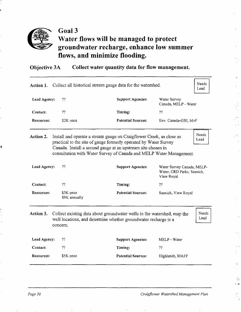
Objective 3A Collect water quantity data for flow management.
Objective 3B Protect and improve the water storage capability of the watershed.
Objective 3C Promote stormwater management that emphasizes infiltration and detention.
Craigflower Watershed Management Plan

Goa14.
GoalS.
Goal6.
Water quality will be improved and maintained.
Objective 4A Integrate and expand water quality monitoring programs.
Objective 4B Improve the quality of storm water released into watercourses.
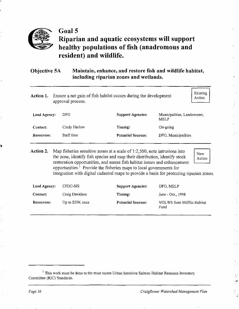
Riparian and aquatic ecosystems will support healthy populations of fish (anadromous and resident) and wildlife.
Objective SA Maintain, enhance, and restore fish and wildlife habitat, including riparian zones and wetlands.
Objective SB Maintain, enhance, and restore fish stocks and wildlife.
Objective SC Ensure adequate water flows to support fish populations.
Native vegetation will be protected and restored throughout the watershed, providing habitat for birds, wildlife, and fish.
Objective 6A Restore native vegetation in areas where it has been removed or degraded.
Objective 6B Protect significant terrestrial areas.
Craigf/ower Watershed Management Plan Page 17

3.3 Work Plan
3.3.1 Top Ten Priority Actions
Initially, the Forum brainstormed a list of actions that would assess, maintain, or improve the health of the watershed. As these actions could not all be undertaken immediately, Forum members completed a priority-setting exercise. The exercise and resulting ranks are shown in Appendix B.
The ten most important items that emerged from the priority setting exercise are listed below.
I. Contact landowners directly to discuss stewardship of the watershed. 1
2. Amend existing bylaws to protect wetlands from clearing, draining, and development. 3. Change zoning bylaws and Official Community Plans to protect the variable riparian
zone defined by mapping of the fisheries sensitive zone. 2
4. Enhance and restore fish habitat. 5. Modify Stormwater Management Bylaws. 6. Produce a digital cadastral layer to overlay on the fisheries sensitive zone map. 2
7. Amend tree-cutting bylaws to prevent tree-cutting and other vegetation removal in the identified riparian zone.
8. Prepare a feasibility study of storing more water in the watershed. 9. Review Official Community Plans and other bylaws to ensure consistency with the
Craigflower Watershed Management Plan. I 0. Continue on-going stock assessment at the Craigflower fish fence.
3.3.2 Detailed Work Plan
Each of the actions proposed by the Forum was designed to meet a specific goal and related objective. Effective watershed management has multiple benefits, so some actions contribute to more than one goal. For example, installing pollutant traps should improve water quality. A benefit of improved water quality will be better fish habitat and healthier fish populations. Hence, this single action could contribute to meeting goals 4 and 5. In general, each action in the detailed work plan is listed under the goal and objective for which it was originally
1 This action must be preceded by another action, "Gather, adapt, and distribute pamphlets about management of the watershed."
2 This action must be preceded by another action, "Map fisheries sensitive zone and provide maps of the fisheries sensitive zone to municipalities.))
Page 18 Craigflower Watershed Management Plan

proposed. When an action will contribute to meeting an additional goal and objective, it is also listed in the work plan as a "related action" under the additional goal and objective.
Each of the actions will be undertaken by a lead agency in cooperation with support agencies. A contact person has been designated for each lead agency. Once the Craigflower Watershed Management Plan has been approved by municipal councils and the CRD Environment Committee, the contact persons will initiate the actions in accordance with the timeline in
Table 2. The support agencies will be approached to provide technical advice, access to relevant information, permission to enter private lands, or other assistance.
Resources needed were estimated for each of the actions. In some instances, staff or volunteer time are required rather than funds. Potential sources of staff time, volunteer time, or funding are suggested for each action. If funding is not available, some of the actions may be delayed.
In the list of actions that follows, the status of each action is indicated with one of the following
labels:
Existing Action An action that is already underway with coordination and funding arranged by a lead agency and contact person.
Program Amendment An action that requires changes to an existing program. The lead agency already manages the program, and changes can occur during regular reviews of the program. Staff time
rather than funding are usually required, but some program amendments will require funding for legal or consulting fees.
New Action An action that requires new funding and has been assigned a lead agency and contact person.
Needs Lead An action that requires new funding and lacks a lead agency and contact person.
Craigf/ower Watershed Management Plan Page /9

Goall Residents and the general public will understand and support stewardship of the watershed.
Objective lA Provide public education about the Craigflower Watershed.
Action 1. Involve elementary school children who live in the watershed in the storm drain marking program.
Lead Agency: VOLWS Support Agencies: DFO, MELP
Contact: John Roe Timing: On-going
Resources: Volunteer time Potential Sources: VOLWS
Action 2. Hold Craigflower Watershed Festival on Rivers Day (September 26, 1998).
Existing Action
New Action
Lead Agency: DFO Support Agencies: CRD ESG, CRD Parks, DFO, Highlands, MELP, Saanich, NGOs, View Royal
Contact: Tom Rutherford Timing: June - Sept. each year
Resources: <$5K annually Potential Sources: Community Sponsors
Action 3. Develop a Craigflower Watershed Web-site with links to Streamkeepers, CRD, and MELP web-sites.
New Action
Lead Agency: VOLWS Support Agencies: DFO, Highlands, Saanich, View Royal
Contact: John Roe Timing: Sept., 1998
Resources: $1K annually Potential Sources: E-Team funding
Page 20 Craigflower Watershed Management Plan

Action 4. Provide a Craigflower component for existing DFO-sponsored school program.
Lead Agency: ?? Support Agencies: DFO,GVSEA,
Contact: ?? Timing: ??
Resources: $5K once + $2K annually Potential Sources: CRD Parks, PCC, DFO
Needs Lead
Action 5. Gather, adapt, and distribute pamphlets about management of the watershed.
Program Amendment
Lead Agency: CRDESG
Contact: Rob Miller
Resources: $5K once
Support Agencies:
Timing:
Potential Sources:
DFO, MELP, PCC
March - July, 1999
CRD ESG, MELP, PCC, DFO, Env. Canada
Objective lB Involve residents in stewardship of the watershed.
Action 1. Contact landowners directly to discuss stewardship of the watershed. New Action
Lead Agency: VOLWS, Highlands Support Agencies: CRDESG, Saanich, View Royal
Contact: John Roe, Kim Carpenter Timing: Jul. -Oct., 1998
Resources: $8K once Potential Sources: VOLWS
Action 2. Provide articles or inserts to community newspapers and organizations. New Action
Lead Agency: PCC
Contact: Dave Morris
Resources: $1K annually
Craigflower Watershed Management Plan
Support Agencies:
Timing:
Potential Sources:
DFO, Highlands, Saanich, View Royal
Jan., 1999- Dec.,2002
CRD ESG, E-Team, MELP, Action 21
Page 21

Action 3. Support the creation of Streamkeepers and Wetland Keepers groups.
Lead Agency: DFO
Contact: Tom Rutherford
Support Agencies:
Timing:
FFL, PIES, PSFed, TPNSA, VRNHAG
Jan., 1999-Dec., 2002
New Action
Resources: Staff time, Volunteer time Potential Sources: Lead and Support Agencies
Objective lC Develop and publicize Best Management Practices for activities occurring in the watershed.
Action 1. Collect existing Best Management Practices (BMPs) for agriculture, construction, logging, stream side living, water use, stream side parks management and industrial, commercial, and institutional land uses. Adapt the BMPs as needed to suit the Craigflower Watershed.
Lead Agency: CRD ESG Support Agencies:
Contact: Rob Miller Timing:
Resources: $5K once Potential Sources:
DFO, MELP, NGOs
Mar. -Aug., 1999
CRD ESG, MAFF, MELP-Water Qlty, DFO, Env. Canada
Action 2. Distribute BMPs to watershed landowners, residents, and business operators and discuss implementation. Municipal offices, CRD Parks, community organizations, and the media can be used as distribution points.
Program Amendment
New Action
Lead Agency: CRD ESG Support Agencies: Highlands, MELP, NGOs, PCC, Saanich, View Royal, VOLWS
Contact: Rob Miller
Resources: $5K once
Page 22
Timing:
Potential Sources:
Aug.- Nov., 1999
CRD ESG, Highlands, View Royal, Env. Canada, DFO
Craigjlower Watershed Management Plan
"

Goal2 Municipalities, the CRD, and provincial and federal governments will develop and use regulatory and management tools to improve the health of the watershed.
Objective 2A Assess watershed implications of existing plans and bylaws.
Action 1. Compile and circulate an inventory of mapping products available for the watershed.
New Action
Lead Agency: CRD Parks Support Agencies: DFO, MELP, Highlands, Saanich, View Royal
Contact: Joel Ussery Timing: May- Jun., 1998
Resources: Staff time Potential Sources: Lead and Support Agencies
Action 2. Assemble a digital cadastral layer to be overlaid on the fisheries sensitive zone map.
New Action
Lead Agency: CRD Parks'
Contact: Joel Ussery
Resources: $1K and staff time
Support Agencies:
Timing:
Potential Sources:
MELP, Highlands, Saanich, View Royal
July- Sept., 1998
CRD Parks
1 As part of the parks planning process, CRD Parks will assemble a digital cadastral layer for the lands surrounding Thetis Lake, Francis-King, and Mill Hill Regional Parks. This layer will be created by combining and goo-referencing digital cadastral from Highlands, Langford, and View Royal and digitizing the required line work from Saanich. If the Forum wishes to use this mapping, permission must be obtained from the municipalities. If this mapping is used with the fisheries sensitive zone mapping, it will only provide a guide to possible development conflicts. Ground-truthing will be essential.
Craig/lower Watershed Management Plan Page 23

Action 3. Review Official Community Plans and other bylaws to ensure consistency with the Craigflower Watershed Management Plan.
Lead Agency:
Contact:
Municipalities
Kevin Key, Highlands Anne Topp, Saanich Barbara Avery, View Royal
Support Agencies: None
Timing: Jan. -May, 1999
New Action
Resources: Staff time Potential Sources: CRD RPS, Highlands, Saanich, View Royal
Action 4. Estimate the land use changes that would result from full build out of current zoning bylaws.
Lead Agency: Municipalities
Contact: Kevin Key, Highlands Anne Topp, Saanich Barbara A very, View Royal
Support Agencies:
Timing:
CRD Parks
Sept. - Dec., 1999
New Action
Resources: $12K and staff time once Potential Sources: CRD RPS, Highlands, View Royal
Objective 2B Use growth management tools to ensure development of appropriate human communities in the watershed
Action 1. Identify Environmentally Sensitive Areas (ESAs) and regulate development in those areas to achieve goals of the Craigflower Watershed Management Plan.
New Action
Lead Agency:
Contact:
Resources:
Page 24
Municipalities
Kevin Key, Highlands Karen Hurley, Saanich Barbara A very, View Royal
Staff time
Support Agencies: MELP
Timing: Jan., 2000 - Dec., 2002
Potential Sources: Municipalities
Craigf/ower Watershed Management Plan

Action 2. Encourage development that maximizes greens pace and protects ESAs.
Program Amendment
Lead Agency: Municipalities
Contact: Kevin Key, Highlands Karen Hurley, Saanich Barbara Avery, View Royal
Support Agencies:
Timing:
MELP, CRD RPS
Jan., 2000-Dec., 2002
Resources: Stafftime Potential Sources: Municipalities
Objective 2C Adopt and enforce municipal bylaws that will protect the watershed and its functions.
Action 1. Enforce bylaws that prohibit building on floodplains.
Lead Agency: Municipalities
Contact: Kevin Key, Highlands Mike Pedneault, Saanich Barbara Avery, View Royal
Resources: Stafftime
Support Agencies:
Timing:
Potential Sources:
MELP
On-going
Municipalities
Action 2. Inform Boards of Variance that under the new fish protection legislation a board cannot issue a variance if the board is of the opinion that the variance would adversely impact the natural envirorunent.
Lead Agency:
Contact:
Resources:
Municipalities
Kevin Key, Highlands Chris Nation, Saanich Barbara Avery, View Royal
Staff time
Craigflower Watershed Management Plan
Support Agencies: MELP,MMA
Timing: January, 1999
Potential Sources: Municipalities
Existing Action
Program Amendment
Page 25

Action 3. Change zoning bylaws and Official Community Plans to protect a variable riparian zone defined by the mapping of the fisheries sensitive zone.
Lead Agency:
Contact:
Resources:
Municipalities
Kevin Key, Highlands Karen Hurley, Saanich Barbara Avery, View Royal
Staff time
Support Agencies: DFO, MELP
Timing: Jan. - Dec., !999
Potential Sources: Municipalities
Action 4. Amend existing bylaws to protect wetlands from clearing, draining, and development.
Lead Agency:
Contact:
Resources:
Municipalities
Kevin Key, Highlands Karen Hurley, Saanich Barbara Avery, View Royal
Staff time
Support Agencies: MELP
Timing: Jun.- Dec., !999
Potential Sources: Municipalities
Action 5. Include applicable portions of Land Development Guidelines for the Protection of Aquatic Habitat in a bylaw to set minimum development standards.
Lead Agency:
Contact:
Resources:
Municipalities
Kevin Key, Highlands Karen Hurley, Saanich Barbara Avery, View Royal
Staff time
Support Agencies: MELP
Timing: Jun. -Dec., 1999
Potential Sources: Municipalities
Program Amendment
Program Amendment
New Action
Page 26 Craigflower Watershed Management Plan

Action 6. Amend tree-cutting bylaws to prevent tree-cutting and other vegetation removal in the riparian zone defined by the mapping of the fisheries sensitive zone.
Program Amendment
Lead Agency: Municipalities Support Agencies: MMA,MELP
Contact:
Resources:
Kevin Key, Highlands Dave Deshane, Saanich Barbara Avery, View Royal
Staff time
Timing: Jun. -Dec., 1999
Potential Sources: Municipalities
Action 7. Require environmental reviews of potentially deleterious construction projects, pre-construction site visits to discuss BMPs, and follow-up site visits to monitor use of BMPs.
New Action
Lead Agency: Municipalities Support Agencies: CRD ESG for BMPs
Contact:
Resources:
Action 8.
Kevin Key, Highlands Karen Hurley, Saanich Barbara Avery, View Royal
Staff time, $12K annually
Timing:
Potential Sources:
Jan., 2000-Dec., 2002
Development Cost Charges
Modify Storm water Management Bylaws so that they are consistent with the CRD's model bylaw and incorporate appropriate sections of the new fish protection legislation to:
Program Amendment
• set a maximum percentage of land that can be covered by impermeable materials,
• •
prohibit increases in runoff from new developments, prohibit pollution and obstruction of flow in watercourses and set penalties for offences.
Lead Agency: Municipalities Support Agencies: CRDESG
Contact:
Resources:
Kevin Key, Highlands Karen Hurley, Saanich Barbara Avery, View Royal
Staff time Legal fees of $20K once
Craigf/ower Watershed Management Plan
Timing:
Potential Sources:
Jul. - Dec., 2000
CRD ESG, Saanich, View Royal
Page 27

Action 9. Ensure that potential storm water retention areas are not developed. New Action
Lead Agency: Municipalities Support Agencies: MELP
Contact:
Resources:
Action 10.
Kevin Key, Highlands Karen Hurley, Saanich Barbara Avery, View Royal
Staff time
Timing:
Potential Sources:
JuL - Dec., 2000
Municipalities
Amend Official Community Plans to include the following requirements (permitted under the new fish protection legislation): • policies to protect and enhance the environment,
Program Amendment
• development approval areas where a developer is required to provide environmental impact information,
•
•
security deposits with development permits for protection of the natural environment, landscaping requirements for the preservation or restoration of the natural environment
Lead Agency: Municipalities Support Agencies: MELP,MMA
Contact:
Resources:
Objective 2D
Kevin Key, Highlands Karen Hurley, Saanich Barbara Avery, View Royal
Staff time
Timing:
Potential Sources:
Jan. -Dec., 2001
Municipalities
Utilize tax incentives to encourage watershed stewardship by landowners.
Action 1. Distribute information to landowners and developers about federal tax benefits of donating lands, certified as ecologically sensitive, to municipalities or authorized conservation organizations.
New Action
Lead Agency:
Contact:
Resources:
Page 28
Municipalities
Kevin Key, Highlands Karen Hurley, Saanich Barbara Avery, View Royal
Staff time
Support Agencies: MELP, Env. Canada
Timing: Jan., 1999- Dec., 2002
Potential Sources: Municipalities
Craigjlower Watershed Management Plan
.•

Action 2. Municipalities will seek conservation covenants on riparian land and explore granting limited property tax exemptions to the landowners as permitted by the new fish protection legislation.
New Action
Lead Agency: Municipalities Support Agencies: MELP, Env. Canada
Contact: Kevin Key, Highlands Karen Hurley, Saanich Barbara Avery, View Royal
Resources: Stafftime
Timing:
Potential Sources:
Jan., 1999-Dec., 2002
Municipalities
Action 3. Reduce property tax assessment on land that is undevelopable because it includes riparian zones, wetlands, or floodplains.
Program Amendments
Lead Agency: Municipalities
Contact: Kevin Key, Highlands Karen Hurley, Saanich Barbara Avery, View Royal
Resources: Stafftime
Craigf/ower Watershed Management Plan
Support Agencies:
Timing:
Potential Sources:
MELP
Jan. 1-Jun. 30, 2000
Municipalities
Page 29
•
Goal3 Water flows will be managed to protect groundwater recharge, enhance low summer flows, and minimize flooding.
Objective 3A Collect water quantity data for flow management.
Action 1. Collect all historical stream gauge data for the watershed.
Lead Agency: ?? Support Agencies: Water Survey
Needs Lead
Canada, MELP- Water
Contact: ?? Timing: ??
Resources: $2K once Potential Sources: Env. Canada-OBI, MoF
Action 2. Install and operate a stream gauge on Craigflower Creek, as close as practical to the site of gauge formerly operated by Water Survey Canada. Install a second gauge at an upstream site chosen in consultation with Water Survey of Canada and MELP Water Management.
Needs Lead
Lead Agency: ?? Support Agencies: Water Survey Canada, MELPWater, CRD Parks, Saanich, View Royal
Contact: ??
Resources: $3K once $9K annually
Timing:
Potential Sources:
??
Saanich, View Royal
Action 3. Collect existing data about groundwater wells in the watershed, map the well locations, and determine whether groundwater recharge is a concern.
Lead Agency: ?? Support Agencies: MELP- Water
Contact: ?? Timing: ??
Resources: $5K once Potential Sources: Highlands, MAFF
Needs Lead
Page 30 Craig/lower Watershed Management Plan
, __ ,..,

Action 4. Using aerial photographs, estimate the amount of impermeable surface in the watershed.
Needs Lead
Lead Agency: ??
Contact: ??
Resources: $7K once
Support Agencies:
Timing:
Potential Sources:
CRD Parks, DFO, MELP
??
Highlands, MMA, Saanich, View Royal
Objective 3B Protect and improve the water storage capability of the watershed.
Action 1. Prepare a feasibility study of storing more water in the watershed. 1
Needs Lead
Lead Agency: ?? Support Agencies:
Contact: ?? Timing:
Resources: $25K once Potential Sources:
Action 2. Implement the recommendations of the feasibility study.
Lead Agency: ?? Support Agencies:
Contact: ?? Timing:
Resources: Unknown Potential Sources:
CRD Parks, DFO, Highlands, MELP -Water, View Royal
??
CRD Parks, DFO, Highlands, View Royal
CRD Parks,
Needs Lead
DFO, Landowners, MELP -Water
??
Highlands, Landowners, View Royal
1 Potential storage sites were identified by the Craigflower Watershed Assessment. The feasibility study should include a hydrological study, ecological effects, public meetings about storing water on public land, and discussions with landowners about the possibilities of storage on private lands.
Craigjlower Watershed Management Plan Page 31

Action 3. Update the Craigflower portion ofMELP's Saanich-Victoria Water Allocation Plan to allocate water for fish. If there are changes in water availability in the watershed due to the eventual completion oActions 3B3B.l and 3B.2, the plan should be modified to reflect those changes.
Program Amendment
Lead Agency: MELP- Water Mgmt Support Agencies: CRD Parks, DFO, Highlands,
Contact:
Resources:
Objective 3C
Saanich, View Royal
Bruno Blecic Timing: Jul. -Dec., 200 I
Line item in MELP budget Potential Sources: MELP- Water Mgmt
Promote stormwater management that emphasizes infiltration and detention.
Action 1. Monitor and maintain the effectiveness ofthe water quality ponds on the Vancouver Island Highway in the Craigflower Watershed. Regularly clean highway catch basins that drain to Craigflower Creek.
Lead Agency: MoTH Support Agencies: None
Contact: Dan Saari Timing: On-going
Resources: Line item in MoTH budget Potential Sources: MoTH
Existing Action
Action 2. Expand regular maintenance programs for municipal stormwater infrastructure, e.g., dredge storm water detention and retention ponds to maintain their original volumes, clean out pollutant traps. Develop handling and disposal plans for solids.
Program Amendment
Lead Agency:
Contact:
Resources:
Page 32
View Royal
Tony Queen
$1K in each of 1999 & 2000 $2K in each of 200 I & 2002
Support Agencies: CRDESG
Timing: Jan. 1999-Dec.2002
Potential Sources: View Royal
Craigjlower Watershed Management Plan

Action 3. Install state-of-the art storm water management infrastructure (e.g., pollutant traps, sand filters, detention ponds) in new developments and retrofit existing developments to reduce peak runoff and improve water quality.
Lead Agency: View Royal Support Agencies: None
Contact: Tony Queen Timing: Jan., 1999-Dec., 2002
New Action
Resources: $15K - $25K per installation Potential Sources: Development Cost Charges
Craigjlower Watershed Management Plan Page 33

Goal4 Water quality will be improved and maintained.
Objective 4A Integrate and expand water quality monitoring programs.
Action I. Continue water quality monitoring and reporting at the mouth of Craigflower Creek as part of the CRD's Annual Storm Water Quality Surveys.
Existing Action
Lead Agency: CRD ESG Support Agencies: None
Contact: Rob Miller Timing: On-going
Resources: $2K annually Potential Sources: CRDESG
Action 2. Monitor water quality "hot spots" to identify sources of contamination. New Action
Lead Agency: CRD ESG
Contact: Rob Miller
Resources: $5K annually
Support Agencies:
Timing:
Potential Sources:
MELP, MoTH
Mar., 1999-Dec., 2002
CRD ESG, MELP
Action 3. Develop water quality monitoring programs with NGOs, Camosun College, and Royal Roads University.
Needs Lead
Lead Agency: ??
Contact: ??
Resources: $5K annually
Related Action.
Support Agencies:
Timing:
Potential Sources:
Camosun, CRD ESG, PIES, RRU, VRNHAG, MELP, DFO, Env. Canada
??
Action 21, DFO, MELP, GBI
Streamkeepers (Action IBJ) could also assist with water quality monitoring.
Page 34 Craigflower Watershed Management Plan
·•

Objective 4B
Related Actions.
Improve the quality of stormwater released into watercourses.
Regular maintenance of stormwater infrastructure in Actions 3C.1 and 3C.2 and installation of state-of-the-art stormwater management infrastructure in Action 3C.3 will improve water quality in Craigflower Creek.
BMPs prepared and distributed in Actions 1 C.l and 1 C.2 will educate the public about controlling sources of contamination from homes, businesses, and farms.
Craigflower Watershed Management Plan Page 35
GoalS Riparian and aquatic ecosystems will support healthy populations of fish (anadromous and resident) and wildlife.
Objective SA Maintain, enhance, and restore fish and wildlife habitat, including riparian zones and wetlands.
Action 1. Ensure a net gain of fish habitat occurs during the development approval process.
Existing Action
Lead Agency: DFO Support Agencies: Municipalities, Landowners,
Contact:
Resources:
Action 2.
MELP
Cindy Harlow Timing: On-going
Staff time Potential Sources: DFO, Municipalities
Map fisheries sensitive zones at a scale of I :2,500, note intrusions into the zone, identify fish species and map their distribution, identify stock restoration opportunities, and assess fish habitat issues and enhancement opportunities.' Provide the fisheries maps to local governments for
New Action
integration with digital cadastral maps to provide a basis for protecting riparian zones.
Lead Agency: CFDC-SIS Support Agencies:
Contact: Craig Davidson Timing:
Resources: Up to $20K once Potential Sources:
DFO, MELP
June- Oct., 1998
VOLWS from Mifflin Habitat Fund
1 This work must be done to the most recent Urban Sensitive Salmon Habitat Resource Inventory Committee (RIC) Standards.
Page 36 Craigjlower Watershed Management Plan

Action 3. Enhance and restore fish habitat.
Lead Agency: GVSEA Support Agencies:
Contact: Peter McCully Timing:
Resources: $7K annually for 4 years Potential Sources:
Action 4. Produce an Environmentally Significant Areas Atlas.
Lead Agency: ?? Support Agencies:
Contact: ?? Timing:
Resources: ?? Potential Sources:
DFO, Landowners, MELP, PIES
New Action
Jul. I, 1999-Dec.31 ,2002
PSF, HREF
CRD, DFO, MELP, Municipalities,
??
DFO, Env. Canada
Needs Lead
Action 5. Develop a management strategy for protection of wildlife habitat. Needs Lead
Lead Agency: ??
Contact: ??
Resources: ??
Related Actions.
Support Agencies:
Timing:
Potential Sources:
CRD Parks, Municipalities, Landowners, DFO
??
Lead & Support Agencies
Wetland Keepers groups created under Action IB.3 will help to protect and possibly restore wetlands.
Actions 3B.l and 3B.2 could lead to the restoration of wetlands for water storage. This restoration work would also contribute to the above objective of maintaining, enhancing and restoring fish and wildlife habitat.
Craig/lower Watershed Management Plan Page 37
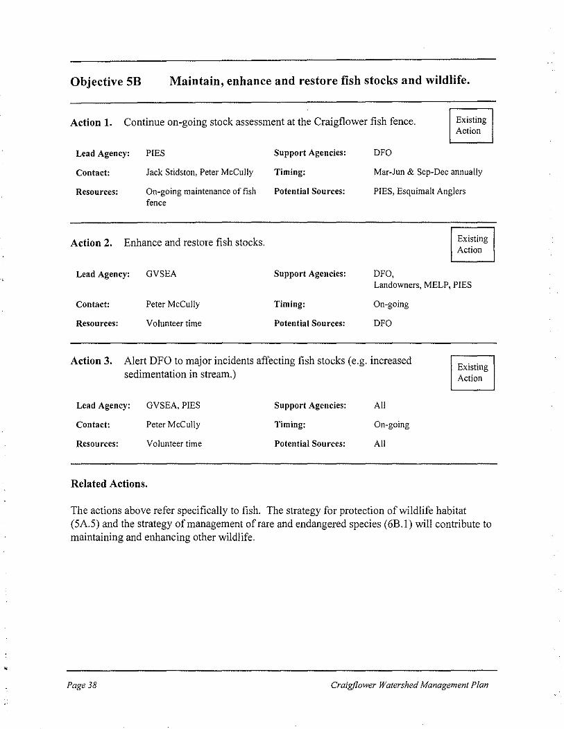
Objective 5B Maintain, enhance and restore fish stocks and wildlife.
Action 1. Continue on-going stock assessment at the Craigflower fish fence. Existing Action
Lead Agency:
Contact:
Resources:
PIES
Jack Stidston, Peter McCully
On-going maintenance of fish fence
Action 2. Enhance and restore fish stocks.
Lead Agency: GVSEA
Contact: Peter McCully
Resources: Volunteer time
Support Agencies:
Timing:
Potential Sources:
Support Agencies:
Timing:
Potential Sources:
DFO
Mar-Jun & Sep-Dec annually
PIES, Esquimalt Anglers
DFO,
Existing Action
Landowners, MELP, PIES
On-going
DFO
Action 3. Alert DFO to major incidents affecting fish stocks (e.g. increased sedimentation in stream.)
Existing Action
Lead Agency: GVSEA, PIES Support Agencies: All
Contact: Peter McCully Timing: On-going
Resources: Volunteer time Potential Sources: All
Related Actions.
The actions above refer specifically to fish. The strategy for protection of wildlife habitat (5A.5) and the strategy of management of rare and endangered species (6B.l) will contribute to maintaining and enhancing other wildlife.
Page 38 Craigflower Watershed Management Plan

Objective SC Ensure adequate water flows to support fish populations.
Related Actions.
Actions 3B.l and 3B.2 could lead to improved water storage which would allow water to be released for fish during periods of dry weather.
Action 3B.3, updating ofMELP's Saanich Victoria Water Allocation Plan, can include allocating water to maintain flows for fish.
Craigflower Watershed Management Plan Page 39

Goal6 Native vegetation will be protected and restored throughout the watershed, providing habitat for birds, wildlife, and fish.
Objective 6A Restore native vegetation in areas where it has been removed or degraded.
Action 1. Identify areas where native vegetation has been removed or is in decline. Concentrate on the areas not examined during the mapping of the fisheries sensitive zone (Action 5A.2).
New Action
Lead Agency: VNHS Support Agencies: BC Hydro, FFL, MELP, PCC, RNSP, Saanich, TPNSA, VRNHAG
Contact: Tony Embleton
Resources: $8K once, Volunteer time
Timing:
Potential Sources:
Apr. - Oct., 1999
BC Hydro, PCC
Action 2. De;velop and implement a replanting and restoration program on private and public property using suitable native species.
Needs Lead
Lead Agency: ??
Contact: ??
Resources: $!8K annually, Volunteer time
Page 40
Support Agencies:
Timing:
Potential Sources:
BC Hydro, CRD Parks, FFL, MELP, PCC, RNSP, TPNSA, VRNHAG, VOL WS
??
BC Hydro, PCC, GBI
Craigflower Watershed Management Plan
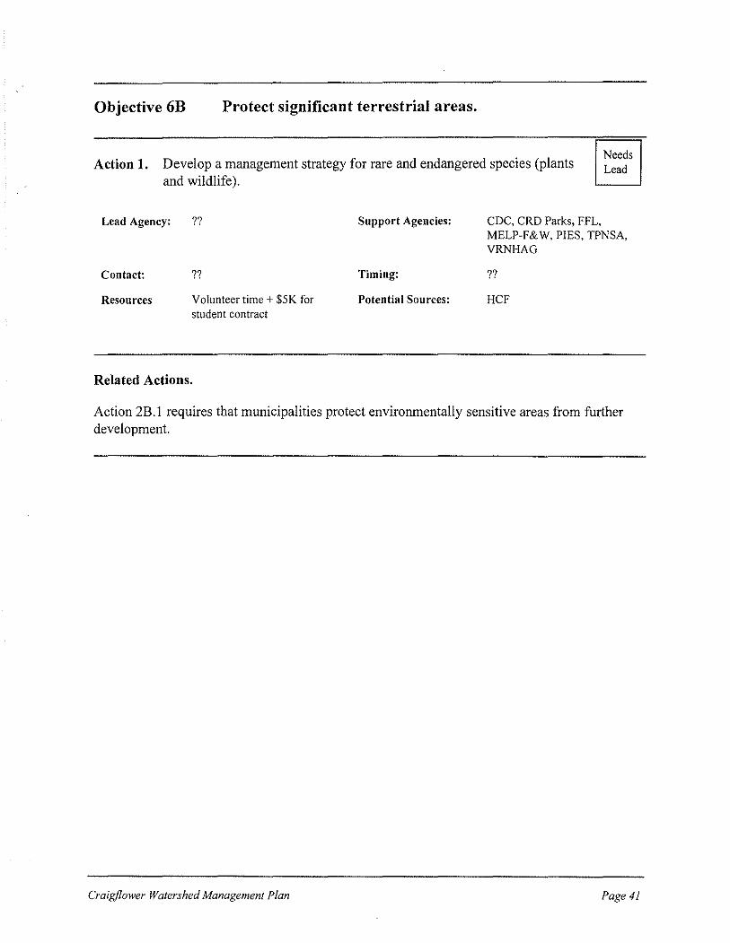
Objective 6B Protect significant terrestrial areas.
Action 1. Develop a management strategy for rare and endangered species (plants and wildlife).
Needs Lead
Lead Agency: ??
Contact: ??
Resources Volunteer time+ $5K for student contract
Related Actions.
Support Agencies:
Timing:
Potential Sources:
CDC, CRD Parks, FFL, MELP-F&W, PIES, TPNSA, VRNHAG
??
HCF
Action 2B.l requires that municipalities protect environmentally sensitive areas from further development.
Craigf/ower Watershed Management Plan Page 41
3.4 Timeline
The proposed timeline for program amendments and new actions is summarized in Table 2. Existing actions and actions that need a lead agency are not included in the timeline. The
actions are grouped by goal.
The timelines extend from May, 1998 to December, 2002. Some actions, such as bylaw amendments, will protect the health of the watershed beyond December, 2002. For planning
purposes, this timeline is limited to five years.
Page 42 Craigjlower Watershed Management Plan

Table 2 Timeline for implementation of new actions and program amendments for the Craigflower Watershed Management Plan
Start Finish 1998 1999 2000 2001 Action
Date Date 2 3 4 --:-·
2 3 4 1 2• 3 4 1 2 3 1 I
Goa/1: Education and Stewardship
r-- __ L 1A.2 Hold Craigftower Watershed Festival on Rivers 6/1998 9/1998
-r-1 I Day (September 26, 1998)
1 8.1 Contact landowners 7/1998 10/1998 -1A.3 Craigftower Web-site 9/1998 9/1998 I
18.2 Provide articles to community newspapers 1/1999 12/2002 I
1 8.3 Support Streamkeepers and Wetland Keepers 1/1999 12/2002 groups
1C.1 Collate and adapt Best Management Practices 3/1999 8/1999 (BMPs)
1A.5 Prepare pamphlets about management of the 3/1999 7/1999 I ~ watershed
1A.2 Hold Craigflower Watershed Festival on Rivers 6/1999 9/1999 .. Day
1 C.2 Distribute BMP recommendations to 8/199.9 11/1999 I ,.. government and media, landowners, residents, and
business operators
1A.2 Hold Craigflower Watershed Festival on Rivers 6/2000 9/2000 I ~ Day
1A.2 Hold Craigflower Watershed Festival on Rivers 6/2001 9/2001 .. Day
1A.2 Hold Craigflower Watershed Festival on Rivers 6/2002 9/2002 Day
-- c---- --· -I
--···~ -----·-- - ------ ---··- __ l '
I I I J l '
2002
4 1 2 3 4
I ~
--+ I
continued ....

J
Table 2 ..... continued
Start Finish 1998 1999 2000 2001 2002 Action
Date Date 2 3 4 1 2 3 4 1 2 3 4 1 2 3 4 1 2 3 4
Goal 2: Regulatory and Management Tools
. -.---· 2A.1 Compile and circulate an inventory of mapping 5/1998 6/1998 • products available for the watershed
2A.2 Assemble digital cadastral layer 7/1998 9/1998 -2C.2 Inform Board of Variance of new powers 1/1999 1/1999
20.1 Inform landowners and developers about federal 1/1999 12/2002 1·-
tax benefits I I I I I I I I I I I J 20.2 Inform property owners of the property tax 1/1999 12/2002 advantages of conservation convenants
2A.3 Review Official Community Plans and other bylaws 1/1999 5/1999 to ensure consistency with the Craigflower Watershed Management Plan
2C.3 Change bylaws to protect a variable riparian 1/1999 12/1999 I--fisheries sensitive zone
2C.4 Amend bylaws to protect wetlands from clearing, 6/1999 12/1999 draining, and development
2C.5 Include "Land Development Guidelines for the 6/1999 12/1999 Protection of Aquatic Habitat" in a bylaw
2C.6 Amend tree-cutting bylaws 6/1999 12/1999
2A.4 Estimate full build out of current zoning bylaws 9/1999 12/1999 r--· -20.3 Reduce tax assessments on riparian zones, 1/2000 6/2000 wetlands and floodplains
28.2 Encourage development that maximizes 1/2000 12/2002 greenspace and protects ESAs
2C.7 Require environmental reviews of appropriate·--- --1/2000-- ... 12/2002 --1-- ·-·
projects
l:is.1 Regulate development in ESAs - -- ··----~ ---i/2000 .... .. 12/2002-- . '"···- --- -- 1--··. -- ---· ·--· - ---. ·--. . ··--·--·
I
continued ......

--
Table 2 ..... continued
Start Finish 1998 I 1999 2000 2001 2002 Action
Date Date 2 3i4j1'2I3T4 1 2 3 4 1 2 3 4 1 2 3 4
2C.8 Modify Stormwater Management Bylaws based on 7/2000 12/2000
I I I
I CRD's model bylaw --
2C.9 Ensure potential stormwater retention areas are 12/2000
I 7/2000
not developed I 2C.10 Amend Official Community Plans to incorporate 1/2001 12/2001
I powers from Bill 26
I
Goal 3: Management of Water Flows -
3C.2 Expand regular maintenance programs for 1/1999 12/2002 I
municipal stonnwater infrastructure I 3C.3 Install state-of-the-art stormwater management 1/1999 12/2002 I infrastructure
3B.3 Update the Craigflower portion of MELP's 7/2001 12/2001 Saanich-Victoria Water Allocation Plan
Goal4: Water Quality
4A.2 Monitor water quality "hot spots" to identify sources 3/1999 12/2002 of contamination
f------- f---
·-·----- ._ ___
--- _______ l_ _______ 1--
I I -- ----
I
-- ~------· ---- 1--
I l • --- --
continued ......
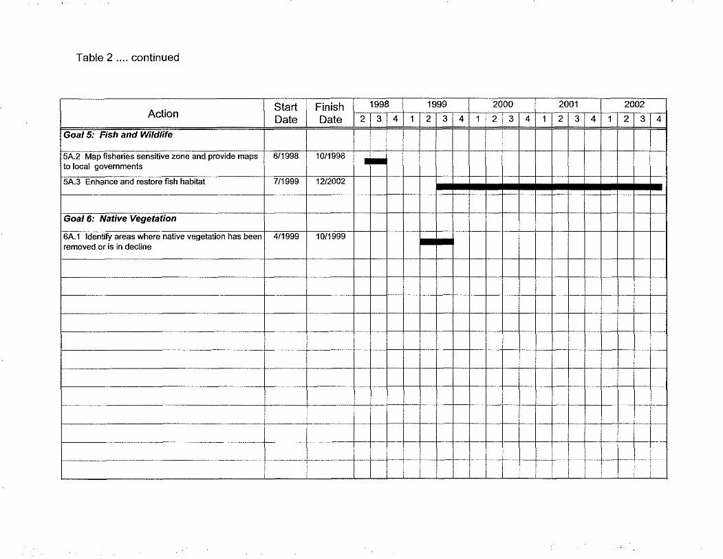
Table 2 .... continued
Action I
Start I Date
Goal 5: Fish and Wildlife
5A.2 Map fisheries sensitive zone and provide maps 6/1998 to local governments
5A.3 Enhance and restore fish habitat 7/1999
Goal 6: Native Vegetation
6A.1 Identify areas where native vegetation has been I 4/1999 removed or is in decline
Finish f 1998 ~ 1999 I 2000 I 2001 I 2002 Date 21314 1 21314 1121314 1121314 1121314
1o1199s I .... 12/2002
10/1999
l------+----t-+-t---il-t--+--+-+-+--+-+-+-1--t---+-+-t--+-+---1
~------------------------+---~~-----~+-+-1--+-~-+-+-+~--~~+-~~~+-+-+--j
1------------------------+-·---+------l- --+--+- -1--+--+---+--+-+-+-+-+-+-+--+
I-- . -+------+----- +--! -J--+--1-+--+··-~f.-
-+ j--------+-+-f--f--f-+-f-·++·j· 1J t L~-···· - ...... -++--1-------- ·----------+-----+---··· -+- +-+-+-·+-+-~--~-
-+--+--!----

3.5 Budget Summary
Table 3 provides an estimate of the new costs involved in implementing the Craigflower Watershed Management Plan over five years. Some annual costs will continue beyond the five
year planning horizon used in this budget.
A total of 17 new actions and program amendments that require new funding are included in this budget. The other 16 new actions and program amendments require staff or volunteer time,
rather than funding. Existing actions are not shown in the budget as they will continue to be
funded as they are at present. Actions that lack a lead agency are not shown as the timing of
those actions is unknown.
Most of the program amendments require additional staff time at the municipal level, rather than new funding. It is possible that demands on staff created by this plan will lead to expenditures for extra staff, if only temporarily. Rather than try to anticipate municipal staff work loads over the next five years and estimate funding for extra staff, it is left to the municipalities to manage
the work load as they see fit.
The amounts suggested for each action are best estimates provided by those members of the Forum who have particular areas of expertise. In some instances, other government staff were
consulted to refine the estimates.
The costs of installing state-of-the art stormwater management infrastructure (Action 3C.3) are particularly difficult to estimate as there are few detailed plans for this work. In addition, there
are questions about how well pollutant traps, detention ponds and similar devices function and
which alternatives are most cost effective.
Most of the required stormwater collection system infrastructure will be installed in View Royal. The Town of View Royal Master Drainage Plan (Ker, Priestman & Associates Ltd., 1990) recommended installation of pollutant traps on 16 outfalls to Craigflower Creek. The Town of View Royal has just adopted a five year drainage plan that includes installing pollutant
traps on two discharges to Craigflower Creek, one in 1998 and one in 2000. Design of the first
pollutant trap is in progress and is estimated to cost $15,000. Pollutant traps can cost up to
$25,000 depending on the size of the catchment. In Table 3, the 1998 pollutant trap has been
estimated at $15,000, the second pollutant trap scheduled for 2000 has been estimated at $25,000. Additional funds will be required beyond the year 2000 to complete improvements to
View Royal's stormwater collection system.
Craigjlower Watershed Management Plan Page 47
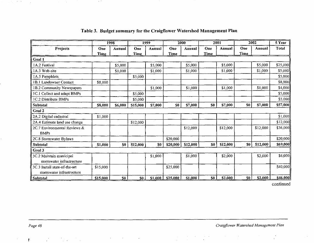
Table 3. Budget summary for the Craigflower Watershed Management Plan
1998 1999 2000 2001 2002 SYear
Projects One Annual One Annual One Annual One Annual One Annual Total
Time TimP TimP TimP TimP
Goal1
I A.2 Festival $5,000 $5,000 $5,000 $5,000 $5,000 $25,000
IA.3 Web-site $1,000 $1,000 $1,000 $1,000 $1,000 $5,000
I A.5 Pamphlets $5,000 $5,000
I B. I Landowner Contact $8,000 $8,000i
I 8.2 Community Newspapers $1,000 $1,000 $1,000 $1,000 $4,000
I C.! Collect and adapt BMPs $5,000 $5,000
I C.2 Distribute BMPs $5,000 $5,000
Subtotal $8,000 $6,000 $15,000 $7,000 $0 $7,000 $0 $7,000 $0 $7,000 $57,000
Goal2
2A.2 Digital cadastral $1,000 $1,000
2A.4 Estimate land use change $12,000 $12,000
2C. 7 Environmental Reviews & $12,000 $12,000 $12,000 $36,000
BMPs
2C.8 Stormwater Bylaws $20,000 $20,000
Subtotal $1,000 $0 $12,000 $0 $20,000 $12,000 $0 $12,000 $0 $12,000 $69,000
Goal3
3C.2 Maintain municipal $!,000 $1,000 $2,000 $2,000 $6,000
stonnwater infrastructure
3C.3 Install state-of-the-art $15,000 $25,000 $40,000
stormwater infrastructure ! Subtotal 'I;JS 000 '1:0 '1:0 '1:1 1100 '1:25 OliO 'i:]JliiO iii ""i2Mfl w i2 000 S046.000
continued
Page48 Craigflower Watershed Management Plan
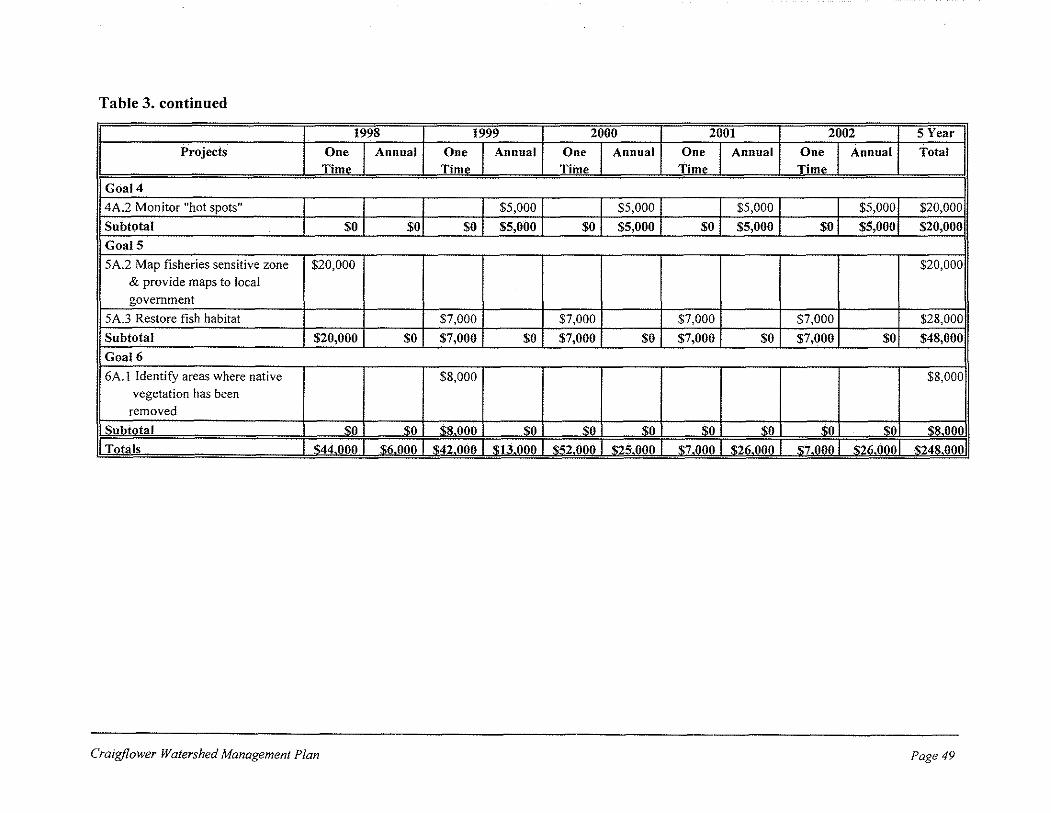
Table 3. continued
1998 1999 2000 2001 2002 5 Year j
Projects One Annual One Annual One Annual One Annual One Annual Total i Time Time Time Time Time
Goal4
4A.2 Monitor "hot spots" $5,000 $5,000 $5,000 $5,000 $20,000,
Subtotal $0 $0 $0 $5,000 $0 $5,000 $0 $5,000 $0 $5,000 $20,000]
GoalS
5A.2 Map fisheries sensitive zone $20,000 $20,000 & provide maps to local government
5A.3 Restore fish habitat $7,000 $7,000 $7,000 $7,000 $28,000
Subtotal $20,000 $0 $7,000 $0 $7,000 $0 $7,000 $0 $7,000 $0 $48,000
Goal6
6A.l Identify areas where native $8,000 $8,000 vegetation has been
removed
ls_ubtotal $0 $0 $8.000 $0 $0 $0 $0 $0 $0 sol $8.000
I Totals I $44,oog I $6,000 I $42,QOO I $1;i,QOO I $22,000 I $22,000 I $7 ,QOO I $2(i,OOQ I s7,QQ!! I :1!2!i,OQol $248,0QO
Craigj/ower Watershed Management Plan Page 49

3.6 Implementation
The Craigflower Watershed Forum was established to develop the Craigflower Watershed Management Plan. Having completed the Plan, the Forum is now dissolved, so implementation of the Plan will be the responsibility of the lead agencies identified for each action. Several organizations may be involved in the action, but the lead agency will be responsible for initiating and coordinating implementation.
Achieving the goals of the Plan requires actions and agencies to be coordinated and the results of the projects to be monitored. The Forum recommends that a Craigflower Watershed Management Steering Committee be struck to replace the Forum and coordinate Plan implementation. The roles of the Steering Committee will be to:
a. Coordinate applications for funding to support actions identified in the Plan; b. Provide a venue for participants to collaborate on scheduling and work programs; c. Track whether actions are implemented and whether the timeline set out in the Plan
is being met; and d. Monitor whether actions are meeting the Plan vision and goals and improving the
health of the Craigflower Watershed.
The Steering Committee will meet at least twice a year. The Forum recommends that the Steering Committee consist of:
• 2 municipal representatives (View Royal and Highlands), • 3 representatives from non-governmental organizations active in the watershed, and • 1 representative from CRD Parks (as manager of30% of the watershed).
Because their lands in the watershed are small, the Districts of Saanich and Langford chose not to be on the Committee, but request to be informed of Committee decisions. Senior levels of government are not represented on the Steering Committee, but will be available to provide technical advice at the request of the Committee.
The Steering Committee could incorporate as a non-profit society under the Societies Act. Nonprofit status would be useful to the Committee in applying for and receiving funds. The Act does not preclude government employees sitting on the Board of a non-profit organization.
Page 50 Craigf/ower Watershed Management Plan

The Forum recommends that a paid coordinator be hired to assist the Steering Committee The coordinator will undertake the following tasks:
a. Convene Steering Committee meetings, and prepare agendas and minutes. b. Identify funding opportunities and coordinate funding applications. c. Distribute materials to the public and press. d. Provide assistance for actions that require inter-agency coordination. e. Be a contact person for questions on the Plan content and implementation. f. Track plan implementation and compile a brieflmplementation Status Report before
the twice-yearly steering committee meetings (see Appendix C for draft Status Report Sheet). Circulate the Report to all Forum members.
g. Compile a Health of the Watershed Summary Report every 3-5 years, so that the Forum can learn if actions are meeting the goals of the Plan (see Appendix D for suggested indicators).
The annual cost for Steering Committee expenses and the coordinator's salary and expenses are estimated to be $15,000 to $25,000. Funding will be sought from government and nongovernmental sources.
Although the Forum is dissolved, all members who have participated in the creation of the Craigflower Watershed Management Plan will be kept up-to-date, by receiving reports from the coordinator summarizing the progress of Plan implementation.
Craigf/ower Watershed Management Plan Page 51

Page 52 Craigjlower Watershed Management Plan
4.0 REFERENCES
Canadian Wildlife Service and Conservation Data Centre. 1997. Sensitive Ecosystems Inventory. Environment Canada and Ministry of Environment, Lands and Parks.
Victoria, BC.
Capital Regional District Parks & Provincial Capital Commission. 1996. Regional Green/Blue
Spaces Strategy. Victoria, BC.
Chilibeck, B., G. Chislett, and G. Norris. 1993. Land Development Guidelines for the
Protection of Aquatic Habitat. Department of Fisheries and Oceans and BC Ministry of Environment. Victoria, BC.
CRD Engineering Department. November, 1997. Staff Report #EES 97-124 re: Watershed
Management Strategy. Capital Regional District. Victoria, BC.
Ker, Priestman & Associates Ltd. 1990 Town of View Royal Master Drainage Plan. Victoria,
BC.
SHIP Environmental Consultants Ltd. 1996. Millstream Watershed Prototype Study. Prepared for the Capital Regional District. Victoria, BC.
SHIP Environmental Consultants Ltd. April, 1997. The Craigf/ower Watershed Assessment.
Prepared for the Capital Regional District. Victoria, BC.
SHIP Environmental Consultants Ltd. June, 1997. Prioritization of watersheds for the
development of Integrated Watershed Management Plans within the "Core Liquid Waste
Management Plan" area. Prepared for the Capital Regional District, Victoria, BC.
Westland Resource Group. 1997. Millstream Integrated Watershed Management
Implementation Plan. Prepared for the Capital Regional District. Victoria, BC.
Craigf/ower Watershed Management Plan Page 53

Page 54 Craigf/ower Watershed Management Plan

APPENDIX A
OPTIONS FOR WATERSHED MANAGEMENT FROM THE CRAIGFLOWER WATERSHED ASSESSMENT
The Craigflower Assessment (SHIP, 1997) proposed the following options for watershed
management:
Land Use
To prevent property damage from flooding and to preserve and enhance the quality of
existing aquatic environments:
• increase the protection of stream channels and floodplains. In particular, undisturbed and unfragmented areas in the upper reaches of the watershed should be preserved, if at all possible, as they function to moderate water flows and maintain water quality, thus benefiting downstream areas of the watershed.
• expand development permit zones to include all floodplains and wetlands. • consider the feasibility of increasing the standard 15 metre leave strips along streams to
30 metres, thereby improving the protection of particularly sensitive or unstable sites.
• specify best management practices within leave strips to ensure the protection of both trees and understorey vegetation.
• utilize in all phases of the land development process, the tools described in Stream
Stewardship: A Guide for Planners and Developers and Land Development Guidelines
for the Protection of Aquatic Habitat.
• adopt the recommendations of the Regional Green/Blue Spaces strategy.
Flooding
To prevent increases in flooding:
• implement a policy of zero increase in storm water runoff from new developments by the use of retention ponds, directing runoff into the ground on-site, or by other methods that may be appropriate.
• protect and enhance existing wetlands so they can function as storm water retention sites.
Agriculture
To minimize the effects of agricultural land use in the watershed:
Craigf/ower Watershed Management Plan Page 55

• create a new land stewardship classification for property taxes that would encourage the
retention of natural aquatic features such as bogs, swamps, and small ponds. • encourage and promote fencing of riparian areas to keep out cattle, pumping of water for
stock from streams to drinking troughs and construction of specific stream crossings for
cattle.
Water Quality
To improve and maintain water quality in the watershed:
• continue investigations of potential and known contaminated sites throughout the
Craigflower drainage area. • install pollutant traps on storm drains throughout the drainage basin. • prevent further damage to stream channels from off-road vehicles in the northwest
portion of Thetis Lake Regional Park, gate all potential access roads and undertake restoration activities to repair the damage to the stream channel caused by off-road
vehicles.
Water Storage
To maintain and improve the natural water storage capabilities within the watershed:
• use development permit areas and new property tax incentives as a method of preventing the development of wetlands.
• provide incentives for restoring wetlands presently used for agriculture. • investigate the feasibility of increasing the water storage capacity at the sites identified in
this assessment.
Public Involvement
To encourage stewardship of the watershed by community and environmental groups:
• publish information about the importance and location of key aquatic environments such
as wetlands, lakes and ponds in the watershed. • encourage the creation of active Streamkeepers groups.
• restore the stream and riparian habitat along the urbanized portion of lower Craigflower Creek. (SHIP, 1997)
Page 56 Craigflower Watershed Management Plan

APPENDIXB
PRIORITY -SETTING EXERCISE
Forum members completed a priority-setting exercise in conjunction with their review of Draft 2 of the Plan. The purpose of the exercise was to identify which of the actions in the Plan were most important to meeting the vision for the Craigflower Watershed, as funding all the actions immediately would be
unrealistic.
Forum members were provided with the information shown in Table B l and asked to rate each action as:
• Crucial, • Important,
• Not Useful, or • Don't Know
in regard to meeting the Craigflower vision.
Responses were received from 17 of the 26 Forum members. The responses were evaluated by assigning
points to each response as follows:
Rating Points
Crucial 5
Important 3
Not Useful 1
Don 1t Know 0
The total points for each action was calculated and normalized using the formula:
Total Points= (C x 5 +I x 3 + NU) I (C +I+ NU)
where: C was the number of members who considered the action crucial, I was the number of members who considered the action important,
NU was the number of members who considered the action not useful.
The actions were then sorted from highest to lowest total points. The action with the highest total points
was ranked 1 (most important) the action with the second highest total points was ranked 2, and so on. The
action with the lowest total points was considered least important. The results of the priority-setting exercise are shown in Table 82.
Craigjlower Watershed Management Plan Page 57

•
As a result of this priority-setting exercise, some actions were dropped, some were combined, and some were split into two actions. The actions were then renumbered. The revised numbers are used throughout the plan. Column one of Table 82 shows the revised numbers and provides a cross-reference between the numbers used in the priority-setting exercise and the numbers used elsewhere in the plan.
Table Bl. Information provided to Forum members with the priority-setting exercise
Action Background Information Discussion
I A. I Pamphlets There are no pamphlets specifically about the Pamphlets could be used in the Landowner Contact
Craigflower Watershed, but generic watershed Program (I 8.1 ), at the Watershed Festival ( IA.2) and in pamphlets are available from MELP & DFO. school programs (I A.3 ).
IA.2 Watershed Festival A public education event to be held on Rivers Day, Could be used to educate residents, landowners. and
the last Sunday in September. visitors and to promote Streamkeepers and Wetland Keepers (18.3).
I A.3 School Program View Royal Elementary School is the only school in Shifting the focus of View Royal Elementary 's the watershed. Students participate in DFO's salmonid program to Craigflower Creek requires salmonids in the classroom program on the Colquitz providing the teachers with easy-to-use programs. River. Focus could be shifted to Craigflower with Could CRD Parks naturalists produce a watershed any additional costs absorbed by DFO. Another program for schools at Thetis Lake Park? program called "Gently Down the Stream" could be
customized for Craigflower, but the cost would be >$5K. Annual funding is needed for an interpreter
and transportation.
IA.4 Web site MELP, CRD. Stream keepers, and VOL WS have A web-site is primarily a public education tool. It could web sites. A Craigflower site could be linked to all complement all the actions under education and the above sites. stewardship. A more complex interactive site could be
designed for Streamkeepers and other observers to
submit observations about conditions in the watershed.
1 B.! Landowner No landowner contact programs have been The intent of this action is to have employees such as E-Contact undertaken in the watershed. VOLWS has Team members or volunteers visit landowners and
compiled a database of landowners in the Gorge businesses to discuss watershed stewardship. It was Watershed, which includes the Craigflower suggested at Workshop 3 that this program might best Watershed. Municipal staff are concerned that the be undertaken by municipalities. individuals conducting this program are very
credible and know the rules versus the options available to landowners.
I 8.2 Articles for Articles about the Craigflower Watershed have not This action would complement other outreach actions community newspapers appeared in local papers. under Objectives I A and I B by keeping the watershed
in the public eye. For example, some articles could
emphasize BMPs to reinforce the work of the landowner contact program.
continued
Page 58 Craigjlower Watershed Management Plan

Table Bl continued
Action Background Information Discussion
lB.3 Streamkeepers and Streamkeepers and Wetland Keepers provide The formation of Strcamkeepers and Wetland Keepers
Wetland Keepers manuals and training programs for volunteers on groups would increase the number of people in the methods of protecting and restoring local aquatic watershed who arc knowledgable about aquatic habitat. DFO can provide support to local citizens systems. Keepers could observe conditions in the
who wish to form a Keepers group. watershed and report problems to the appropriate agencies before serious harm is done. Keepers' efforts
need to be consistent with the goals and actions of the Watershed Management Plan.
!C. I BMPs are a tool for educating residents and Adapting existing BMPs to the local situation is often
Collect and adapt BMPs businesses about ways to reduce their impact on the more cost-effective than starting from scratch. In some
watershed. CRD ESG has already begun cases performance standards are more appropriate than
assembling BMPs for various activities. MELP BMPs.
Water Quality is currently assembling a BMPs
compendium. It was suggested at Workshop 3 that
municipalities adapt the BMPs to suit the
Craigflower Watershed.
I C.2 Distribute BMPs Highlands can distribute BMPs through existing Making BMPs readily available to residents, business
systems, the development information process, and operators, and developers increases the likelihood that
stewardship outreach. Saanich and View Royal do the watershed will be protected from unnecessary
not have money available for distributing BMPs. damage.
2A.I Mapping Inventory There is no comprehensive Jist of maps available for A list of available mapping products would assist all the watershed. agencies working in the watershed.
2A.2 Estimate future Highlands has already conducted this work. View This exercise would allow the municipalities, residents,
land usc changes Royal is presently reviewing its OCP, but no staff and the Forum to envision the total impact of future
time is allocated to this action. No funding is development in the watershed. available from CRD Parks or Saanich.
2A.3 Review OCPs & This work has been completed in Highlands. This project would include appropriate watershed bylaws Saanich could provide staff time only for this work. planning actions in OCPs.
No staff time has been allocated in View Royal.
2A.4 Digital cadastral Municipalities rely mainly on paper cadastral maps. The intent of this action is to provide municipal staff layer The Sensitive Ecosystems Inventory mapping with maps that combine cadastral and environmental
prepared by senior agencies is available digitally at sensitivity data. These maps could be used to help I :20,000. The cadastral layer could form part ofthc protect environmentally sensitive areas from
Environmentally Significant Areas Atlas (Action inappropriate development. 5A.6)
2B.I Protect ESAs The Highlands OCP contains policies to regulate Is protection ofESAs already covered by IB.l
development in "Environmental Protection Areas''. (landowner contact). 2A.3 (OCPs). 28 (various The Saanich OCP does not include protection of bylaws), 2E.l (conservation covenants)? Does
ESAs. protection of ESAs need to be a separate item here? The View Royal OCP (1990) designates lands on
Seymour Hill and along Craigtlower Creek where it
forms the Saanich-View Royal border as
environmental protection areas because of their
steep slopes.
continued
Craigf/ower Watershed Management Plan Page 59

Table Bl continued
Action Background Information Discussion
2B.2 Clustered The Highlands OCP calls for clustering Carefully designed clustered development can provide
Development development where suitable to avoid impacts on high·quality housing, allow residents to enjoy the
Environmental Protection Areas. amenities of adjacent greenspace, and protect ESAs.
2C.I Protect a variable At present riparian setbacks are: The concept of a variable riparian setback based on
riparian zone Highlands 30m mapping of the fisheries sensitive zone allows for
Saanich 7.5m protection of sensitive areas and development in less
View Royal 15m sensitive areas.
2C.2 Tree-cutting bylaw Existing tree·cutting bylaws: Maintaining trees and understorey vegetation in the Highlands~ discourages logging and land~clearing; riparian zone is important for stabilizing banks, will protect significant trees. wildlife trees, and transferring nutrients to the stream, and moderating treed areas with a Tree Protection Bylaw. water temperature. In upland areas. maintaining trees Saanich w prohibits cutting of any tree within 15m of reduces erosion, protects wildlife habitat, preserves the natural boundary of a watercourse, unless the aesthetics, and retains biodiversity. tree or its roots are obstructing drainage. Trees may not be removed from floodplains. View Royal- OCP(J990) encourages retention of trees> 20cm in diameter or 6 m in height & encourages restrictive covenants to protect trees.
2C.3 Prohibit building Highlands- OCP states that floodplains will be left Prohibiting building on floodplains avoids property on floodplains in a natural state or used as parks or greenways. damage protects public safety as well as protecting
Saanich- Zoning bylaw prohibits building on a riparian and aquatic systems. It appears that the three floodplain municipalities have dealt with this matter, so should this View Royal - OCP map ( 1992) designates most action be dropped or amended? creek side lands as "parks and open space". An exception is the Marler subdivision where houses were built on the floodplain prior to town incorporation.
2C.4 Wetlands Highlands - OCP includes wetlands in Wetlands are valuable to the health of the watershed protection bylaw Environmental Protection Areas because they store water during heavy rains, which
Saanich ~ Intends to add wetland protection to their maintains stream flows and provides groundwater Watercourse Bylaw that will be revised beginning recharge. Wetlands also filter water and provide in June, 1998. important habitat for amphibians, fish and waterfowl. View Royal - 15m setback from natural boundaries of wetlands.
2C.5 Include Land The Guidelines are extensive and would result in a large Development Guidelines bylaw. Should municipalities adopt only relevant for the Protection of sections in a bylaw? Aquatic Habitat in a bylaw.
continued
Page 60 Craigjlower Watershed Management Plan

Table Bl continued
Action Background Information Discussion
2C.6 Environmental Highlands calls for assessments of specific This action would provide site visits with the developer
reviews and construction developments. Saanich has a detailed ESR process. and contractor after approval of a project and before
site visits View Royal has a more modest approach. All these construction begins. Follow up visits would occur
reviews occur prior to project approval. during construction. The intent of this action is to educate the construction industry about BMPs and to
encourage BMPs as a means of protecting water quality and fish habitat.
2C. 7 Storm water The CRD developed a model stormwater The new fish protection legislation will enable
Management Bylaws management bylaw for modification and adoption municipalities to reduce peak runoff and protect water
by the municipalities. The model bylaw can be quality.
expanded to include new powers given to
municipalities by the new fish protection legislation.
2C.8 No development in In Workshop 2, participants wanted areas for Does this require amending OCP's or zoning bylaws?
storm water retention storm water retention to be protected from alienation Could this action be included with another action such
areas by development. as 2C.9? Municipalities may need to budget funds for
purchasing such areas.
2C.9 Amend OCP's to The new fish protection legislation gives There arc few precedents for the usc of these powers.
use new fish protection municipalities the power to develop policies to
legislation powers protect and enhance the environment. The
Highlands OCP has as its first and most important
goal, "Protect the integrity of the natural
environment''.
2C.l 0 Powers to Boards Traditionally, Boards of Variance rule on requests Does this require any action from the municipalities or
of Variance to deviate from the exact requirements of a bylaw. is this simply a rule change that needs to be conveyed to
Under the new fish protection legislation, Boards of Boards of Variance?
Variance may not issue a variance ifthc natural
environment will be adversely affected.
20.1 Primary contact in Highlands has a part-time, temporary Stewardship Actions 20.1, 20.2, and 20.3 arc concerned with plan
each municipality Coordinator. Saanich has a full-time Environmental implementation. There may be other means of co-
Planner. operating to implement the plan. Should the plan
include such recommendations for municipal (or senior
government) staffing? Ideas will be discussed at future
meetings of the Forum.
20.2 Maintain the The CRD Board established the Forum to prepare
Forum the Watershed Management Plan. No on-going role
was recommended by the Board.
20.3 Participate in John Roe of VOL WS is promoting a watershed Potential exists for overlap between membership and
Gorge Watershed council with a councillor from each of the 7 mandate of the Forum and the Council.
Council municipalities within the Gorge Watershed.
continued
Craigjlower Watershed Management Plan Page 61

Table Bl continued
Action Background Information Discussion
2E, l Conservation The new fish protection legislation allows Property tax exemptions provide an incentive for
covenants and tax municipalities to accept conservation covenants on landowners to protect riparian lands with conservation
exemptions riparian land and to grant property tax exemption to covenants. The cost of the tax exemptions is borne
the land owners. Highlands has 57 covenants with entirely by the municipalities. The cost to a more to come, but Council has decided not to grant municipality may be less where farm land that is tax exemptions until criteria for granting already subject to reduced taxes is placed under a
exemptions are developed. conservation covenant.
2E.2 Reduce taxes rates A landowner can use the BC Assessment The intent of this action is to acknowledge that riparian
on riparian zones. Authority's existing appeal process to request a zones, wetlands. and floodplains are less valuable to the
wetlands. and reduction in assessment as the land is owner because they are undevelopable. Is any action
floodplains. undevelopable. Tax rates need not be changed. required in the Craigflower Plan or is this concern covered by Actions 2E.I. 2E.3. and BC Assessment appeals? Presumably, municipalities and the Forum would endorse appeals.
2E.3 Federal tax benefits Certain income tax benefits can result from donating Municipalities may not want to own or maintain all
of donating ecologically ecologically sensitive lands to a nature trust or local donated land.
sensitive lands. government. A professional biologist must verify the ecological value of the donated land.
2F.l Annual Status An Annual Status Report would track the Report implementation of the Craigflower Watershed
Management Plan. If the report were published early in each year, it could assist in budgeting for watershed actions in the coming year.
2F.2 Health of the The CRD already publishes the Report on the A Health of the Watershed Summary Report monitors Watershed Summary Environment, covering the entire region. conditions in the watershed and indicates whether the Report actions from this plan are improving the watershed.
The Report would publish in one place the results of other monitoring actions (e.g. 4A.l, 4A.2, 4A.3).
3A.l Collect historical Water Survey Canada operated a gauge on Historical stream flow data provide a baseline for stream gauge data. Craigflower Creek downstream of Burnside Road comparing present flows and evaluating the impacts of
from 1974 to 1981. development in the watershed. These data would be useful for the water storage feasibility study (38.1 ).
3A.2 Map groundwater Many residents in Highlands rely on groundwater Understanding groundwater use and recharge provides use. for domestic water supply. Wells in some parts of more information about the movement of water in the
the Highlands may run dry in summer. District of watershed. Highlands assigns low priority to a groundwater survey.
3AJ Reactivate the Water Survey Canada staff in Nanaimo were not On-going water quantity data would allow comparisons Water Survey Canada aware of the Craigflower gauge. They are checking with historical flows in the creek and would be valuable gauge on Craigflower their files and will provide information on the type for the water storage feasibility study (38.1). Creek of gauge, whether it is still in place, and costs of
reactivating it.
continued
Page 62 Craigflower Watershed Management Plan

Table Bl continued
Action Background Information Discussion
3A.4 Additional stream Water Survey Canada will provide information on This gauge could be monitored by the same staff person
gauge the types of gauges available and costs. Neither who monitors the gauge in 3A.3. The possibility of
Saanich nor View Royal have money available for monitoring by community volunteers could be explored stream gauging at this time. Placing a gauge
upstream of Riverside Ridge could provide a measure of the impacts of subdivisions and the
highway on stream discharge.
3A.5 Estimate amount The new fish protection legislation authorizes local One Forum member commented. "Not needed. So what of impermeable surface government to develop a bylaw to establish a ifit's l5%or8%or2l%? Whatisthecurrcnteffect?
in the watershed. maximum percentage of land that may be covered Too many qualifiers." Can we drop this action?
by impermeable material. An ideal percentage is
not given in the Bill. Saanich could provide staff
time for this action and significant research on
"effective" impervious cover measurements. No
money is available from Saanich or View Royal at
this time.
38.1 Feasibility study of This study was recommended by the Craigflower Increasing low summer flows would increase available
increasing water storage Watershed Assessment. From a fisheries fish habitat (5A.3 and SC). This can be done by storing perspective this is a top priority. Funding for this more water in wetlands and ponds during the wet
study would not come from MELP or View Royal. season for release during the dry season. CRD Parks is
CRD Parks and Saanich could provide staff time. concerned about changes caused by flooding of
wetlands in parks The feasibility study is needed to
identify water storage areas and evaluate changes to
hydrology of the system, ecosystem effects. and
concerns of all stakeholders.
38.2 Implement No comment from Highlands at Workshop 3. Until the study is done it is impossible to estimate the
recommendations of Saanich commented that a council report and budget costs of implementation. Costs might be borne by feasibility study. item would be required for the municipality to landowners who benefit from an additional pond on
contribute to this action. View Royal commented their lands, municipalities who might use the ponds as a that no money is available at this time. backup for fire-fighting. Some costs might be borne by
province and by the residents of the CRD who benefit
from improved fish stocks.
38.3 Update MELP's MELP Regional Water Management regularly If water storage in the Craigflower Watershed were water allocation plan. prepares water allocation plans that compare water increased as a result of implementing the above
use to available water supply and make feasibility study, the additional available water should recommendations for future water use. be noted in the Water Allocation Plan. The water could
be designated for use by fish (Objective 5C).
3C.I Maintain Maintenance of the storm water infrastructure for the
stonnwater Island Highway is funded by the Highway infrastructure. Maintenance Contract. No money or staff time arc
allocated in View Royal.
continued
Craigf/ower Watershed Management Plan Page 63

Table Bl continued
Action Background Information Discussion
3C.2 Install state-of- the The recent Vancouver Island Highway Project A Forum member commented," Many dots for such a
art stormwater included installation of state-of-the-art storm water small area impacted by degraded storm water runoff'
management infrastructure. The View Royal Master Drainage This action was meant to include stormwater
infrastructure Plan (1990) recommended installation of pollutant management techniques such as on-site disposal of traps on 16 discharges to Craigtlower Creek. stormwater, swales. more impermeable surfaces, Highway construction has not altered any of those detention ponds, and retention ponds. These techniques
discharges. View Royal has just adopted a 5 year are probably applicable to small developments in drainage plan that includes installing pollutant traps Highlands and Saanich and to new developments in on 2 discharges to Craigflower Creek. one in 1998 View Royal. The 16 pollutant traps are needed to and one in 2000 (T. Queen, pers. Comm.) This type upgrade existing infrastructure in View Royal. of infrastructure is not needed in Highlands or Saanich.
4A.I On-going water CRD Environmental Services Group samples water This monitoring progran1 is on~going and provides a
quality monitoring and sediment near the mouth of Craigflower Creek "snapshot" of conditions in the creek at the time of as part of the Annual Stormwater Quality Survey. sampling. More extensive sampling would be needed Fecal co!iforms are measured in water samples to truly judge conditions in the watershed. collected twice per year. Sediments, collected once per year. are tested for metals and PAHs. The 1997 sampling program showed moderate levels of concern for fecal coliforms and low/moderate concerns for sediment contamination.
4A.2 Monitor water In addition to the above monitoring, DFO This action would allow for more detailed quality "hot spots" investigates water quality if there is a fish kilL investigations of water quality problems when they
occur.
4A.3 Monitoring by Both Camosun College and RRU have Qualitative monitoring (e.g. for water discolouration ) volunteers and students environmental studies programs that require by PIES volunteers or Streamkeepers can be done at no
students to complete projects. Student and cost. instructor time would be available at no cost, but funding would be required for testing of samples at an analytical lab. DFO could supply training and water quality monitoring equipment.
5A. I Fisheries sensitive CFDC-S!S planned to do this work from May to zone mapping and August, 1998. As of May I 9, 1998, funding has not assessment been received for the project.
5A.2 Fisheries zone The intent of this action is to provide local governments maps to local with the location of the fisheries sensitive zone so that government they can protect it from development. This action will
provide the information necessary for defining the variable riparian zone that is to be protected by Action 2C.I. Could this action be combined with SA. J?
continued
Page 64 Craigjlower Watershed Management Plan

Table Bl continued
Action Background Information Discussion
5A.3 Enhance and The amount of funding required for this action will
restore fish habitat depend on the assessment of fish habitat that is part
of Action 5A.l. Funding may be available from
Fisheries Renewal BC, who prefers to see
community~based partnerships for projects. As of
Workshop 3, VOL WS is taking the lead in applying
for funding.
5A.4 Net gain of fish DFO has a policy of requiring a net gain in fish Since the Fisheries Act is reactive, DFO can only advise
habitat during habitat during development. Urban development the developer in advance and Jay charges later if fish
development. proposals are referred to DFO and MELP whose habitat is damaged. Municipal bylaws could be staff meet on-site with the developer to discuss his proactive in requiring improvements to fish habitat.
plans.
SA. 5 Management CRD Parks is working on a Management Plan for
strategy for protection of Thetis, Francis~King and Mill Hill Parks.
wildlife habitat. Protection of wildlife habitat will be included in the
plan. CRD Parks will share information with those
planning for habitat protection outside the Park.
The SEI and a soon-toRbe-relcased conservation
manual from MELP could be used in preparing the
strategy.
5A.6 Environmentally The atlas would be enhanced by using an This project could include the mapping actions listed in
Significant Areas Atlas orthophoto with sufficient resolution to be enlarged 2A.I, 2A.4. 5A. I, and 5A.2. All the agencies
to 1:5,000. CRD Parks is investigating the cost of mentioned in those actions could be involved in the
such a photo for the management plan mentioned atlas project and costs could be integrated. How will
above. Additional coverage for the rest of the the Atlas be used to improve watershed management?
Craigtlower watershed might not increase costs
significantly.
5B.I On-going stock This is a continuing project of PIES. Esquimalt
assessment Anglers provides funding for maintenance of the
fish fence.
5B.2 Enhance and GVSEA already operates a volunteer fish stocking
restore fish stocks program with full capabilities. Stock restoration
decisions are made by MELP and DFO.
5B.3 Alert DFO to This work is already done by volunteers from Streamkeepers, Wetland Keepers and other volunteers
major incidents affecting GVSEA and PIES when they are working in the could increase the total area under observation.
fish. watershed.
5C.I Include water for This item can be included in Action 38.3 ,update of If actions 3B.3 and 5C. 1 arc done after the water
fish in MELP's water the water allocation plan. storage feasibility study and its implementation (38.1
allocation plan. and 38.2), more water should be available for
maintaining flows for fish.
continued
Craigjlower Watershed Management Plan Page 65
Table Bl continued
Action Background Information Discussion
6A.I Identify areas The mapping of the fisheries sensitive zone (Action
where native vegetation SA. I) will include noting where vegetation needs to
should be restored. be replaced. VNHS was originally suggested as the lead for this project. If 5A. I goes ahead, VNHS may only have to cover the upland areas of the
watershed.
6A.2 Replanting VNHS was suggested as a lead agency for this Planting native species on private land could be
program project. They feel it is unlikely they could carry out encouraged through pamphlets (I A. I) and landowner this program without a hired professional person contact (I B. I). working full-time.
6B.I Management This strategy could begin with data about rare and The Craigflower drainage could be used as an example strategy for rare and endangered species available from the CDC and show casing the use of SEI maps and the SEI endangered species TPNSA. CRD Parks will be including rare and Conservation Manual.
endangered species in its Management Plan for Information about protecting rare and endangered Thetis, Francis-King and Mill Hill Parks. CRD species could be distributed through pamphlets ( lA. I) Parks would share information with those working and landowner contact (I B. I). Checking for rare and to protect rare and endangered species outside the endangered species should form part of ESRs prior to park. development approval.
Page 66 Craigjlower Watershed Management Plan
Table B2. Results of priority-setting exercise- June 10, 1998
---i Ratings and Points I
Revised Crucial Important Not Don't Total Ranking
Useful Know Points
No. Actions 5 3 1 0
lB. I I B.l Landowner Contact 12 4 0 1 4.50 1
2C.4 2C.4 Wetland protection bylaw 9 7 0 1 4.13 2
2C.3 2C.l Protect variable riparian zone 8 8 0 1 4.00 3
5A.2 5A.2 Provide fisheries maps to local govt 7 7 0 4 4.00 4
5A.3 5A.3 Restore fish habitat 6 6 0 5 4.00 5
2C.8 2C.7 Stormwater Bylaws 7 8 0 2 3.93 6
2A.2 2A.4 Digital cadastral 6 7 0 4 3.92 7
2C.6 2C.2 Tree-cutting bylaw 6 7 0 4 3.92 8
3B.l 3B.l Study water storage feasibility 6 4 1 5 3.91 9
5A.2 5A.l Map fisheries sensitive zone 7 9 0 1 3.88 10
2A.3 2A.3 Review OCPs 6 9 0 2 3.80 11
5B.l 5B.l On-going stock assessment 5 8 0 4 3.77 12
lB.3 1 B.3 Stream & Wetland Keepers 6 10 0 1 3.75 13
2C.5 2C.5 Land Development Guidelines 4 7 0 6 3.73 14
1C.2 1 C.3 Distribute BMPs 4 8 0 5 3.67 15 •
6B.l 6B.l Protect rare and endangered species 4 8 0 5 3.67 16
3C.3 3C.2 Install state-of-the art stormwater 4 9 0 4 3.62 17 i
infrastructure •
3B.2 3B.2 Implement feasibility study 4 5 1 8 3.60 18
2D.3 2E. 2 Reduce taxes on undevelopable land 4 10 0 3 3.57 19
4A.l 4A.l Continue water quality monitoring 4 10 0 3 3.57 20
lC.l 1 C.l & 1 C.2 Collect & adapt BMPs 3 8 0 6 3.55 21
continued
Craigflower Watershed Management Plan Page 67

Table B2 continued ~~-
--~-- --- - ~- -
Ratings and Points
Revised Crucial Important Not Don't Total Ranking Useful Know Points
No. Actions 5 3 1 0
20.2 2E.I Riparian Conservation Covenants 4 II 0 2 3.53 22
2A.l 2A.l Mapping Inventory 4 7 I 5 3.50 23
2C.7 2C.6 Environmental Reviews & 8MPs 3 9 0 5 3.50 24
5A.4 5A.6 Environmentally Significant Areas Atlas 4 7 I 5 3.50 25
IB.2 I 8.2 Community Newspapers 3 12 0 2 3.40 26
28.1 28.1 Regulate development in ESAs 5 9 2 I 3.38 27
2C.9 2C.8 Protect storm water retention areas 2 3 I II 3.33 28
3A.l 3A.l Historical stream gauge data 2 10 0 5 3.33 29
3C.!& 3C.I Maintain stormwater infrastructure 2 10 0 5 3.33 30 3C.2
58.2 58.2 Restore fish stocks 2 10 0 5 3.33 31
58.3 58.3 Alert DFO to incidents affecting fish 3 8 I 5 3.33 32
5A.I 5A.4 Net gain of habitat during development 2 II 0 4 3.31 33
6A.l 6A.I Identify areas where native vegetation has 2 12 0 3 3.29 34 been removed
6A.2 6A.2 Replant with native species 2 I3 0 2 3.27 35
IA.2 IA.2 Festival 2 I4 0 I 3.25 36
38.3 5C.l Include water for fish in Allocation Plan 2 5 I 9 3.25 37
2C.IO 2C.9 Apply the new fish protection legislation I 9 0 7 3.20 38 to OCPs
Dropped 20.1 Primary contact person I 9 0 7 3.20 39
2D.I 2E.3 Federal tax benefits I 9 0 7 3.20 40
4A.2 4A.2 Monitor "hot spots" 2 8 I 6 3.18 41
2A.4 2A.2 Estimate land use change 2 9 I 5 3.17 42 I
continued
Page68 Craigflower Watershed Management Plan

Table B2 continued
Ratings and Points
Revised Crucial Important Not Don't Total Ranking
Useful Know Points
No. Actions 5 3 1 0 .
5A.5 5A.5 Strategy to protect wildlife habitat I 13 0 3 3.14 43 J 2B.2 2B.2 Clustered development I 15 0 I 3.13 44
'
2C.I 2C.3 No building on floodplains 6 5 5 I 3.13 45
2C.2 2C.IO New powers for Board of Variance 0 7 0 10 3.00 46
Dropped 2F.I Annual Status Report 0 14 0 3 3.00 47
Dropped 2F.2 Health of Watershed Report 0 9 0 8 3.00 48
3A.2 3A. 4 Install additional gauge 0 6 0 11 3.00 49
3A.3 3A.2 Groundwater mapping 2 6 2 7 3.00 50
3A.2 3A.3 Reactivate stream gauge I 11 l 4 3.00 51
3B.3 3B.3 Update Water Allocation Plan l 7 I 8 3.00 52
4A.3 4A.3 Monitoring by volunteers 0 12 0 5 3.00 53
lA.4 l A.3 School Programs 12 I 4 2.85 54
lA.5 l A.l Pamphlets l 10 3 3 2.71 55
Dropped 2D.2 Maintain Forum l 4 2 10 2.71 56
lA.3 lA.4 Web-site 7 2 8 2.56 57
Dropped 2D.3 Participate in Gorge Watershed Council 0 4 2 ll 2.33 58
3A.4 3A.5 Man imnermeable surfaces 0 5 3 9 2.25 59 ----· -. -
Craigjlower Watershed Management Plan Page 69

-Page 70 Craigjlower Watershed Management Plan

APPENDIXC
STATUS REPORT SHEET
This Appendix contains a Status Report Sheet for tracking actions that have been implemented. Once the plan has been approved, the Steering Committee will circulate the sheet annually to Forum members to identify which actions have been implemented, and which actions are outstanding. The Steering Committee can then compile a Status Report on Plan Implementation for circulation to Forum members and to participating governments (CRD Board, municipal
councils, provincial and federal ministers).
Status Report for the Craigflower Watershed Management Plan.
Action Lead Agency Contact Date If not completed, comment on Completed status
!A. I Storm drain marking program
IA.2 Festival
!A.3 Web-site
!A.4 School Programs about fish
IA.5 Pamphlets !B. I Landowner Contact
!B.2 Community Newspapers
IB.3 Stream & Wetland Keepers
!C. I Collect and adapt BMPs
IC.2 Distribute BMPs
2A.l Mapping Inventory
2A.2 Digital cadastral
2A.3 Review OCPs
2A.4 Estimate land use change 2B.l Regulate development in ESAs
28.2 Clustered development
2C.l No building on floodplains
2C.2 New powers for Board of Variance
2C.3 Protect variable riparian zone
2C.4 Wetland protection bylaw
2C.5 Land Development Guidelines
2C.6 Tree-cutting bylaw
2C.7 Environmental Reviews & BMPs
2C.8 Stormwater Bylaws
2C.9 Protect stormwatcr retention areas
2C.l 0 Apply the new fish protection
legislation to OCPs 2D.l F cderal tax benefits
Craigjlower Watershed Management Plan Page 71
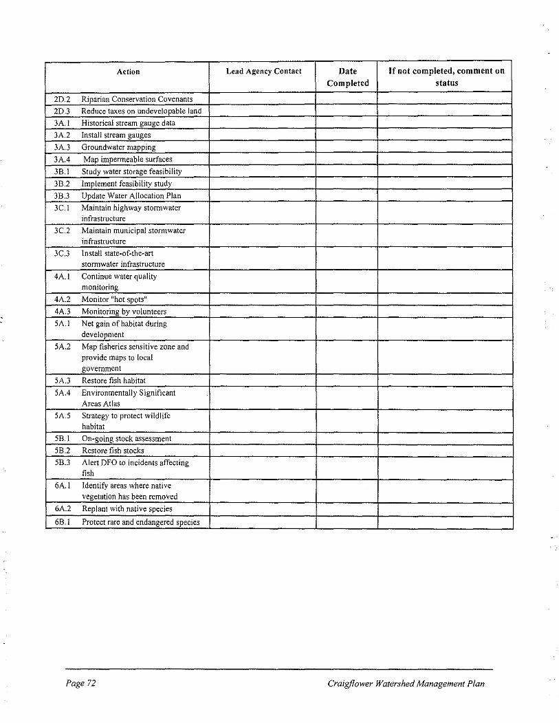
Action Lead Agency Contact Date If not completed, comment on Completed status
2D2 Riparian Conservation Covenants
2D.3 Reduce taxes on undevelopable land
3A.I Historical stream gauge data
3A.2 Install stream gauges
3A.3 Groundwater mapping
3A.4 Map impermeable surfaces
3B.I Study water storage feasibility
3B.2 Implement feasibility study
3B.3 Update Water Allocation Plan
3C.I Maintain highway stormwater infrastructure
3C.2 Maintain municipal stormwater infrastructure
3C.3 Install state-of-the-art storrnwater infrastructure
4A.! Continue water quality monitoring
4A.2 Monitor "hot spots"
4A.3 Monitoring by volunteers
SA.! Net gain of habitat during development
5A.2 Map fisheries sensitive zone and provide maps to local government
5A.3 Restore fish habitat
5A.4 Environmentally Significant Areas Atlas
5A.5 Strategy to protect wildlife habitat
5B.! On-going stock assessment
5B2 Restore fish stocks
58.3 Alert DFO to incidents affecting fish
6A.I Identify areas where native vegetation has been removed
6A.2 Replant with native species
6B.I Protect rare and endangered species
Page 72 Craigf/ower Watershed Management Plan

APPENDIXD
SUGGESTED INDICATORS FOR USE IN PREPARING HEALTH OF THE WATERSHED SUMMARY REPORTS
The Craigflower Watershed Management Steering Committee should monitor the success of the Watershed Management Plan through compilation of a "Health of the Watershed Summary Report" every 3-5 years. This report should use measurable indicators to evaluate whether the
health of the watershed is improving, remaining constant or degrading. Is Plan implementation resulting in a watershed that meets the vision and goals of the Craigflower Watershed Forum? The table below lists some potential indicators for each goal of the Craigflower Watershed Management Plan. The indicators should be directly relevant to each goal, with reliable data
available on an ongoing basis.
Goal Potential Indicators Data Sonrce I. Residents and the general • Percent of residents surveyed who Would require new public will understand and understand key principles of watershed survey support good stewardship of the management watershed.
Percent of residents surveyed who • practice key principles of watershed management
2. Municipalities, the CRD, • Number of actions proposed in the Annual Craigflower and provincial and federal Craigflower Plan that have been Watershed
governments will develop and implemented. Management Plan use regulatory and management Status Report tools to improve the health of the watershed. 3. Water flows will be • Groundwater recharge levels at selected Would require managed to protect groundwater wells monitoring recharge, enhance low summer
• Low summer flows at Craigflower Would require flows, and minimize flooding.
stream gauge. installation of
gauge (Action
3A.2)
• Number of times that houses built outside of the 100 year floodplain have
Municipal records
been flooded.
• Percent of watershed that is under Would require impermeable surfaces. completion of
Action 3A.4.
Craigjlower Watershed Management Plan Page 73

Goal Potential Indicators Data Source
4. Water quality will be • Fecal coliform levels in Craigflower CRD Engineering
improved and maintained. Creek
• Substances of environmental concern in CRD Engineering
sediments at Craigflower Creek point of discharge (chemical contaminants)
• Other water quality parameters Volunteer water sampling (Action 4A.3)
5. Riparian and aquatic • Percent of stream length and waterbody CRD Parks ecosystems will support healthy perimeter with intact adjacent native populations of fish (anadromous vegetation (by habitat type). and resident) and wildlife.
• Index of biotic integrity (stream invertebrates; food for fish) DFO, PIES
• Annual fish counts by species (e.g., Coho) at Craigflower fish fence, and PIES selected lakes and streams in the watershed.
6. Native vegetation will be • Area of intact native vegetation in CRD Parks, protected and restored Craigflower Watershed. VRNHAG, VNHS throughout the watershed, • Percent of watershed in protected status CRD Parks and providing habitat for birds,
(including parks, ecological reserves municipalities wildlife and fish.
and conservation covenants).
Page 74 Craigjlower Watershed Management Plan


