TS26 Best Practice in Facility Management Patrick Levesque PP26.5 Creation and Use of 3D As-built Models at EDF FIG Working Week 2003 Paris, France, April 13-17, 2003 1/14 Creation and Use of 3D As-built Models at EDF Patrick LEVESQUE, France Keywords: 3D as-built models, scanning, CAD, simulation. SUMMARY The Surveying Section of the EDF Generation and Trading Branch uses 3D laser scanners for the fast and accurate capture of sets of 3D points in hazardous environments. The 3DIPSOS software package enables the different views of an observed scene to be consolidated (i.e. tied into a single coordinate system). The objects surveyed can then be modelled by fitting geometric shapes to the cloud of X,Y,Z points, thus creating a complete physical layout of the industrial environment. The final 3D model can be exported to different CAD packages such as PDMS, Microstation, 3DStudio, etc. These models are used for simulation or training purposes. The aim of this presentation is to discuss three applications carried out at EDF : − as-built modelling of unit 2 reactor building at Gravelines nuclear power plant (NPP) for the training of polar crane drivers using virtual reality (VR) technology, − as-built modelling of equipment at St Alban NPP for maintenance, − as-built modelling of the reactor building at Brennillis NPP for the dismantling process. RESUME La Division Topographie de la Branche Energie d’EDF (Electricité de France) utilise des scanners lasers 3D pour la saisie rapide et précise d'un semis de points 3D en environnement hostile. A partir de ce semis de points le logiciel 3DIPSOS permet de consolider les différents points de vue du nuage de points pour ensuite modéliser par entités géométriques les différents objets relevés et recréer l'environnement. Le modèle 3DIPSOS peut s’exporter vers d’autres logiciels de CAO (PDMS, Microstation, 3DStudio, ...). Ces modèles sont ensuite utilisés à des fins de simulations ou de formations. L’objet de cet exposé est de présenter 3 applications réalisées à EDF : − la modélisation Tel Que Construit du bâtiment réacteur 2 de Gravelines pour un projet de formation des pontiers grâce à la réalité virtuelle, − la modélisation Tel Que Construit d’un équipement dans la centrale de St Alban en vue de son replacement, − la modélisation TQC de l’enceinte réacteur de Brennillis dans le cadre du démantèlement
Transcript
TS26 Best Practice in Facility Management Patrick Levesque PP26.5 Creation and Use of 3D As-built Models at EDF FIG Working Week 2003 Paris, France, April 13-17, 2003
1/14
Creation and Use of 3D As-built Models at EDF
Patrick LEVESQUE, France Keywords: 3D as-built models, scanning, CAD, simulation. SUMMARY The Surveying Section of the EDF Generation and Trading Branch uses 3D laser scanners for the fast and accurate capture of sets of 3D points in hazardous environments. The 3DIPSOS software package enables the different views of an observed scene to be consolidated (i.e. tied into a single coordinate system). The objects surveyed can then be modelled by fitting geometric shapes to the cloud of X,Y,Z points, thus creating a complete physical layout of the industrial environment. The final 3D model can be exported to different CAD packages such as PDMS, Microstation, 3DStudio, etc. These models are used for simulation or training purposes. The aim of this presentation is to discuss three applications carried out at EDF : − as-built modelling of unit 2 reactor building at Gravelines nuclear power plant (NPP)
for the training of polar crane drivers using virtual reality (VR) technology, − as-built modelling of equipment at St Alban NPP for maintenance, − as-built modelling of the reactor building at Brennillis NPP for the dismantling process. RESUME La Division Topographie de la Branche Energie d’EDF (Electricité de France) utilise des scanners lasers 3D pour la saisie rapide et précise d'un semis de points 3D en environnement hostile. A partir de ce semis de points le logiciel 3DIPSOS permet de consolider les différents points de vue du nuage de points pour ensuite modéliser par entités géométriques les différents objets relevés et recréer l'environnement. Le modèle 3DIPSOS peut s’exporter vers d’autres logiciels de CAO (PDMS, Microstation, 3DStudio, ...). Ces modèles sont ensuite utilisés à des fins de simulations ou de formations. L’objet de cet exposé est de présenter 3 applications réalisées à EDF : − la modélisation Tel Que Construit du bâtiment réacteur 2 de Gravelines pour un projet
de formation des pontiers grâce à la réalité virtuelle, − la modélisation Tel Que Construit d’un équipement dans la centrale de St Alban en vue
de son replacement, − la modélisation TQC de l’enceinte réacteur de Brennillis dans le cadre du
démantèlement
TS26 Best Practice in Facility Management Patrick Levesque PP26.5 Creation and Use of 3D As-built Models at EDF FIG Working Week 2003 Paris, France, April 13-17, 2003
2/14
Creation and Use of 3D As-built Models at EDF
Patrick LEVESQUE, France 1. INTRODUCTION 1.1 Introduction to the Surveying Section Within the Generation and Trading Branch of Electricité de France (EDF), the Surveying Section of the Electromechanical Department (Centre National d'Equipement de Production d'Electricité – CNEPE) undertakes all engineering survey work in connection with electricity production. Thanks to well-proven methods and qualified personnel who are highly experienced in the construction and maintenance of nuclear, hydroelectric and conventional thermal power stations, the Surveying Section is able to meet the needs of its clients for work requiring a high degree of skill and a guarantee of technical quality. 1.2 Organisation The Surveying Section is made up of two teams based at Lyons and Tours using identical equipment and methods, within a framework of quality assurance procedures conforming to the ISO9001 standard. The two teams comprise about thirty engineers and technicians, most of whom have qualified at specialised surveying colleges and have also gained extensive on-the-job experience. Some of the staff are qualified to operate in nuclear environments (Radiologically Controlled Areas) in accordance with stringent safety regulations. 1.3 Main Activities The Surveying Section is distinguished by its ability to organise the survey work for power stations from the design stage and throughout construction and operation, but it is also able to respond rapidly to complex dimensional and positioning problems with strict tolerances. The skills of the Surveying Section enable it to engage in a wide variety of activities, notably the following: − methods for the survey and adjustment of control networks and for dimensional
monitoring surveys, − high precision measurement and industrial metrology, − application and optimisation of computing tools, − surveys for changes in the EDF property portfolio, − applied research and development in surveying,
TS26 Best Practice in Facility Management Patrick Levesque PP26.5 Creation and Use of 3D As-built Models at EDF FIG Working Week 2003 Paris, France, April 13-17, 2003
3/14
− internship of students − participation in the work of national organisations such as:
- the French standards organisation (AFNOR), - the French photogrammetry and remote sensing society (SFPT), - the French topographic association (AFT) - the French quality movement (MFQ), - the national commission for geographical information (CNIG), - the French committee of representation on FIG.
1.4 Techniques Used The topographic survey profession uses a wide range of scientific and engineering techniques including: - geodesy (definition of reference systems and geodetic control networks), - cartography (production of topographic maps and plans using drafting tools), - photogrammetry (production of topographic maps and plans using metric aerial or
close range photography), - thermography (measurement of sea or river surface temperatures), - bathymetry (marine and fluvial depth soundings (or hydrography)), - profile measurement (measurements to define the inside surfaces of tunnels and
underground galleries), - topometry and industrial metrology (high precision close range dimensional
measurements), - modelling in three dimensions (as-built surveys), - property surveys (definition of property).
High precision measurements Bathymetry/hydrography Dimensional monitoring
TS26 Best Practice in Facility Management Patrick Levesque PP26.5 Creation and Use of 3D As-built Models at EDF FIG Working Week 2003 Paris, France, April 13-17, 2003
4/14
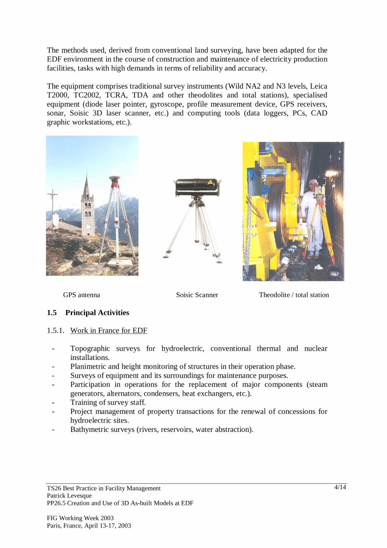
The methods used, derived from conventional land surveying, have been adapted for the EDF environment in the course of construction and maintenance of electricity production facilities, tasks with high demands in terms of reliability and accuracy. The equipment comprises traditional survey instruments (Wild NA2 and N3 levels, Leica T2000, TC2002, TCRA, TDA and other theodolites and total stations), specialised equipment (diode laser pointer, gyroscope, profile measurement device, GPS receivers, sonar, Soisic 3D laser scanner, etc.) and computing tools (data loggers, PCs, CAD graphic workstations, etc.).
GPS antenna Soisic Scanner Theodolite / total station 1.5 Principal Activities 1.5.1. Work in France for EDF
- Topographic surveys for hydroelectric, conventional thermal and nuclear installations.
- Planimetric and height monitoring of structures in their operation phase. - Surveys of equipment and its surroundings for maintenance purposes. - Participation in operations for the replacement of major components (steam
generators, alternators, condensers, heat exchangers, etc.). - Training of survey staff. - Project management of property transactions for the renewal of concessions for
hydroelectric sites. - Bathymetric surveys (rivers, reservoirs, water abstraction).
TS26 Best Practice in Facility Management Patrick Levesque PP26.5 Creation and Use of 3D As-built Models at EDF FIG Working Week 2003 Paris, France, April 13-17, 2003
5/14
1.5.2. Work for Third Parties in France - Participation in research projects with the French geophysics institute (Institut de
Physique du Globe) for monitoring the Fournaise volcano on the island of Réunion and for ongoing studies of tectonic plates in the Pyrenees.
- Technical support and project management for the setting up and checking of the geometry of the Olympic bobsleigh run at la Plagne.
- Control networks and monitoring of the Aube and Manche storage centres for the French national agency for nuclear waste management (Agence Nationale pour la Gestion des Déchets Radioactifs – ANDRA).
- Dimensional monitoring of motorway bridges near le Havre and Rochefort. - Project management for the surveying portion of the subterranean research
laboratory project of Meuse / Haute-Marne (ANDRA BURE). 1.5.3. Work Abroad (“Export”) - Control networks and monitoring of cooling towers for ELECTRABEL (Belgium)
and technical specifications for cooling tower monitoring for ENEL (Italy). - Direction of the survey team of the Chinese project manager for the construction of
the DAYA-BAY nuclear power plant in the Peoples’ Republic of China. - Topographic reconnaissance surveys of hydroelectric sites in Guinea, Gabon, Laos,
and Indonesia. - JOHN AMOS research project on cooling tower plumes (USA). - Provision of GPS control for bridge construction in Denmark. - Dimensional monitoring of structures in Morocco. - Supervision of survey work for construction of the Large Hadron Collider (LHC) at
the CERN nuclear research centre (Geneva). 2. THE IMPORTANCE OF 3D AS-BUILT MODELLING TECHNOLOGY FOR
EDF 2.1 EDF Nuclear Plants The EDF nuclear industry plays an important role in France. It comprises the following plants: - 58 pressurised water reactors (PWRs) in operation (34 units of 900 MW, 20 units of 1300
MW and 4 units of 1450 MW); the first has been in operation since the 1970s and the latest is only four years old;
- in terms of dismantling, to date 12 units have been decommissioned: these comprise 1 heavy water reactor (HWR), 9 gas-cooled reactors (GCRs), 1 PWR and 1 fast breeder reactor (FBR).
TS26 Best Practice in Facility Management Patrick Levesque PP26.5 Creation and Use of 3D As-built Models at EDF FIG Working Week 2003 Paris, France, April 13-17, 2003
6/14
PWR nuclear power plant GCR plant HWR plant 2.2 Importance of As-Built Technology in EDF The use of 3D As-Built technology by EDF is justified for four major reasons: 2.2.1 Ageing Production Plants EDF has safeguarded this production capacity over the past 30 years through a very large maintenance programme based on concerns about both safety and performance. The plants have undergone many modifications which have not always been well documented. In addition it should be emphasised that out of 58 plants in operation only the last four were entirely designed using CAD software. For all of the others, only paper drawings exist, relating to the work of different groups of specialists, but these are not always reliable because of only partial revisions. 2.2.2 Developments in the Regulation of Nuclear Environments The nuclear industry environment no longer allows the use of traditional techniques which directly expose the workers to radiation. The new regulations, based on the “as low as reasonably achievable” (ALARA) principle, have reduced the annual exposure limit for nuclear power workers from 50 mSv to 20 mSv. In this context it is inconceivable that power plant drawings could be updated by workers using conventional instruments inside the plant. This is why 3D scanner technology (sensors capturing clouds of points in order to create 3D as-built models) was conceived and developed through research studies at EDF from 1985 onwards, and has now been in operation in the Surveying Section for the past five years. One of the main advantages of these scanners is that they can be operated by remote control, so that the operators avoid exposure to radiation. 2.2.3 Changes in the Economic Environment The economic environment now obliges EDF to adapt to new rules on opening the market in electricity and thus to supplying energy at a competitive cost. The extension of the life of nuclear units is one means of achieving this competitiveness, but it demands increased maintenance work in order to guarantee a high level of safety. The use of 3D As-Built models also contributes to this aim thanks to simulation software which enables the optimisation of major maintenance operations.
TS26 Best Practice in Facility Management Patrick Levesque PP26.5 Creation and Use of 3D As-built Models at EDF FIG Working Week 2003 Paris, France, April 13-17, 2003
7/14
2.2.4 The Dismantling of Nuclear Installations In the same way as for maintenance, dismantling also faces the problem of lack of reliability of plant drawings, as well as the development of regulation under the ISO14001 standard (covering, among other things, the management and traceability of waste). This is why the simulation of alternative dismantling scenarios using realistic 3D models makes possible the optimisation of the available solutions. 3. AS-BUILT MODELLING IN THE SURVEYING SECTION 3.1 Introduction The use of as-built technology began in 1996 when the EDF R&D Unit lent a prototype scanner (named Soisic) to the Surveying Section for its initial trials. Two surveyors were trained to use the equipment by MENSI (a subsidiary company of EDF). It very soon became clear that this instrument would provide a useful addition to our capabilities and that we would be able to bring our experience to bear in order to improve the equipment. After more than a year of testing and use of this prototype in six different real environments, the EDF Surveying Section decided to procure a new scanner which would be better suited to nuclear plants. This is why the Surveying Section asked EDF R&D and MENSI to consider a scanner which could be used in hostile environments. In 1998 the Surveying Section bought a new scanner sealed against airborne contamination. For the processing of 3D models the Surveying Section also uses MENSI 3DIPSOS software, and for data transfer purposes, CAD software such as PDMS, MicroStation, AutoCAD or Robcad. 3.2 Experience Acquired during Recent Years Today the As-Built Survey team of the EDF Surveying Section consists of four surveyors who are trained to use the scanner, to construct models using 3DIPSOS software and to export the data to CAD packages. These surveyors have extensive knowledge of the nuclear environment and are accustomed to using conventional instruments such as theodolites. This knowledge is particularly important because it allows the following: - connection of all surveys using scanners to a common coordinate system (whether or not
connected to the local reference system); - freedom from the need for objects to be visible from multiple scanner stations (each
station is coordinated in the same reference system); - control of the accuracy of fixation of scanner stations relative to each other (the accuracy
of surveyed points often being considerably better than that of the cloud of points produced by the scanner).
The different as-built surveys carried out over the past five years have also allowed the production of written procedures whose goal is to bring together a compilation of best practice for the deployment of this measurement process. These procedures, which represent the collective experience gained to date, form an important contribution to quality assurance. As-built surveys have been carried out as follows over the past three years: - 7 scanning projects (for a total of 1250 hours) in 2000.
TS26 Best Practice in Facility Management Patrick Levesque PP26.5 Creation and Use of 3D As-built Models at EDF FIG Working Week 2003 Paris, France, April 13-17, 2003
8/14
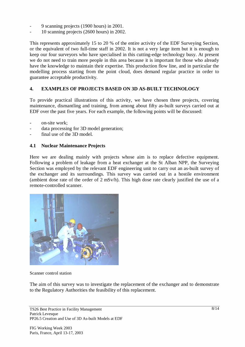
- 9 scanning projects (1900 hours) in 2001. - 10 scanning projects (2600 hours) in 2002. This represents approximately 15 to 20 % of the entire activity of the EDF Surveying Section, or the equivalent of two full-time staff in 2002. It is not a very large item but it is enough to keep our four surveyors who have specialised in this cutting-edge technology busy. At present we do not need to train more people in this area because it is important for those who already have the knowledge to maintain their expertise. This production flow line, and in particular the modelling process starting from the point cloud, does demand regular practice in order to guarantee acceptable productivity. 4. EXAMPLES OF PROJECTS BASED ON 3D AS-BUILT TECHNOLOGY To provide practical illustrations of this activity, we have chosen three projects, covering maintenance, dismantling and training, from among about fifty as-built surveys carried out at EDF over the past five years. For each example, the following points will be discussed: - on-site work; - data processing for 3D model generation; - final use of the 3D model. 4.1 Nuclear Maintenance Projects Here we are dealing mainly with projects whose aim is to replace defective equipment. Following a problem of leakage from a heat exchanger at the St Alban NPP, the Surveying Section was employed by the relevant EDF engineering unit to carry out an as-built survey of the exchanger and its surroundings. This survey was carried out in a hostile environment (ambient dose rate of the order of 2 mSv/h). This high dose rate clearly justified the use of a remote-controlled scanner.
Scanner control station The aim of this survey was to investigate the replacement of the exchanger and to demonstrate to the Regulatory Authorities the feasibility of this replacement.
TS26 Best Practice in Facility Management Patrick Levesque PP26.5 Creation and Use of 3D As-built Models at EDF FIG Working Week 2003 Paris, France, April 13-17, 2003
9/14
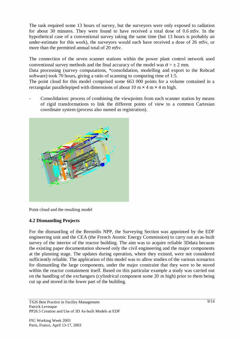
The task required some 13 hours of survey, but the surveyors were only exposed to radiation for about 30 minutes. They were found to have received a total dose of 0.6 mSv. In the hypothetical case of a conventional survey taking the same time (but 13 hours is probably an under-estimate for this work), the surveyors would each have received a dose of 26 mSv, or more than the permitted annual total of 20 mSv. The connection of the seven scanner stations within the power plant control network used conventional survey methods and the final accuracy of the model was σ = ± 2 mm. Data processing (survey computations, *consolidation, modelling and export to the Robcad software) took 70 hours, giving a ratio of scanning to computing time of 1:5. The point cloud for this model comprised some 663 000 points for a volume contained in a rectangular parallelepiped with dimensions of about 10 m × 4 m × 4 m high. - Consolidation: process of combining the viewpoints from each scanner station by means
of rigid transformations to link the different points of view to a common Cartesian coordinate system (process also named as registration).
Point cloud and the resulting model 4.2 Dismantling Projects For the dismantling of the Brennilis NPP, the Surveying Section was appointed by the EDF engineering unit and the CEA (the French Atomic Energy Commission) to carry out an as-built survey of the interior of the reactor building. The aim was to acquire reliable 3Ddata because the existing paper documentation showed only the civil engineering and the major components at the planning stage. The updates during operation, where they existed, were not considered sufficiently reliable. The application of this model was to allow studies of the various scenarios for dismantling the large components, under the major constraint that they were to be stored within the reactor containment itself. Based on this particular example a study was carried out on the handling of the exchangers (cylindrical component some 20 m high) prior to them being cut up and stored in the lower part of the building.
TS26 Best Practice in Facility Management Patrick Levesque PP26.5 Creation and Use of 3D As-built Models at EDF FIG Working Week 2003 Paris, France, April 13-17, 2003
10/14
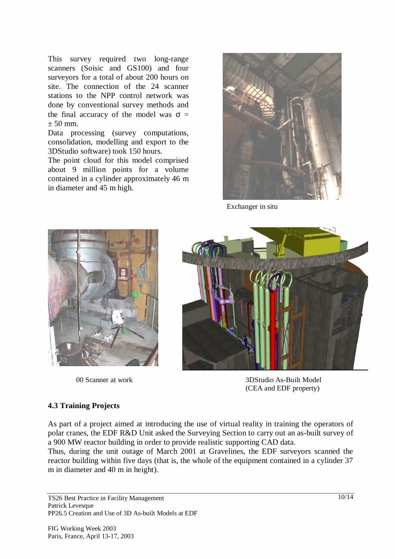
Exchanger in situ
00 Scanner at work 3DStudio As-Built Model
(CEA and EDF property) 4.3 Training Projects As part of a project aimed at introducing the use of virtual reality in training the operators of polar cranes, the EDF R&D Unit asked the Surveying Section to carry out an as-built survey of a 900 MW reactor building in order to provide realistic supporting CAD data. Thus, during the unit outage of March 2001 at Gravelines, the EDF surveyors scanned the reactor building within five days (that is, the whole of the equipment contained in a cylinder 37 m in diameter and 40 m in height).
This survey required two long-range scanners (Soisic and GS100) and four surveyors for a total of about 200 hours on site. The connection of the 24 scanner stations to the NPP control network was done by conventional survey methods and the final accuracy of the model was σ = ± 50 mm. Data processing (survey computations, consolidation, modelling and export to the 3DStudio software) took 150 hours. The point cloud for this model comprised about 9 million points for a volume contained in a cylinder approximately 46 m in diameter and 45 m high.
TS26 Best Practice in Facility Management Patrick Levesque PP26.5 Creation and Use of 3D As-built Models at EDF FIG Working Week 2003 Paris, France, April 13-17, 2003
11/14
This was the first time that a survey of this size had been carried out with this technology (MENSI scanners) and it demanded a major effort, given the limited time available for the task. A team of three surveyors, using three scanners, surveyed between 5 and 6 million points; 400 digital photographs were also captured in order to provide texture for the 3D model and thus portray the environment with greater realism.
One of the three Soisic Scanners in place on the gangway beneath the polar crane in the Gravelines reactor building. The 3D modelling and texturing processes, which required more than three months work, then allowed the R&D engineers to take over and create the VR environment (Virtool software) which will be used for training the crane drivers. The accuracy of this model was σ = ± 5 cm.
3DIPSOS model of unit 2 reactor building at Gravelines
TS26 Best Practice in Facility Management Patrick Levesque PP26.5 Creation and Use of 3D As-built Models at EDF FIG Working Week 2003 Paris, France, April 13-17, 2003
12/14
Model before texturing Texturing (facing the geometric model with photographic images) allowed the production of visually realistic models.
Model after texturing This model, which conforms geometrically and visually to the operational space within the Gravelines reactor building in a realistic way, can also be used for other purposes such as maintenance, management of packaging during unit outages, induction of staff new to the environment, and publicity.
TS26 Best Practice in Facility Management Patrick Levesque PP26.5 Creation and Use of 3D As-built Models at EDF FIG Working Week 2003 Paris, France, April 13-17, 2003
13/14
Final Virtool model In a continuation of what was achieved at Gravelines in 2001, the EDF Surveying Section carried out a second as-built survey of another type of reactor building (1300 MW) during the September 2002 unit outage, with the scanning again taking five days. Two scanners, the GS100 together with a new MENSI scanner based on time-of-flight technology and thus much quicker than previous models (rate exceeding 1000 Hz), were used successfully. These two scanners enabled the survey of 19 million points, more than three times as many as for the previous survey. The modelling process is currently in progress. 5. CONCLUSION This new technique, based on laser ranging, provides a tool which is complementary to other methods already available and, in particular, to photogrammetry. In fact there is often too much of a tendency to compare these two systems of measurement as if they were direct competitors. The laser technique will provide directly useable 3D data (X,Y,Z points) more rapidly with an accuracy of between a few mm and several cm while photogrammetry provides more accurate data but requires longer photogrammetric plotting time. Thus, photogrammetry is more advantageous when there is a requirement for data structured to indicate the limits of different objects, or to show more accurate detail in some parts of the scene. To conclude, I would like to emphasise that this technique is not yet in routine use at EDF because it is still a very new technology with which people have not become entirely familiar, especially in nuclear plants or in dismantling projects where drawings are more often used than CAD models. However, the younger staff is beginning to adopt it. Up to now we have been dealing only with our internal EDF customers, but we are aiming to extend our activities beyond EDF and to make our experience known outside the nuclear field.
TS26 Best Practice in Facility Management Patrick Levesque PP26.5 Creation and Use of 3D As-built Models at EDF FIG Working Week 2003 Paris, France, April 13-17, 2003
14/14
In France, the non-nuclear As-Built Survey market (including the chemical, motor, paper and off-shore industries, civil engineering and the management of national heritage) is currently covered by a dozen companies equipped with scanners and which are beginning to have considerable experience of this activity. In my opinion, the more this technology is known the more it will be used, and thus more decision makers will understand the advantages of the As-Built CAD model. CONTACTS Eng. Patrick Levesque Electricité de France 8, rue de Boutteville BP0437 37204 Tours FRANCE Tel + 33 2 47 21 20 03 Fax + 33 2 47 21 26 02 Email: [email protected] Web site: www.edf.fr