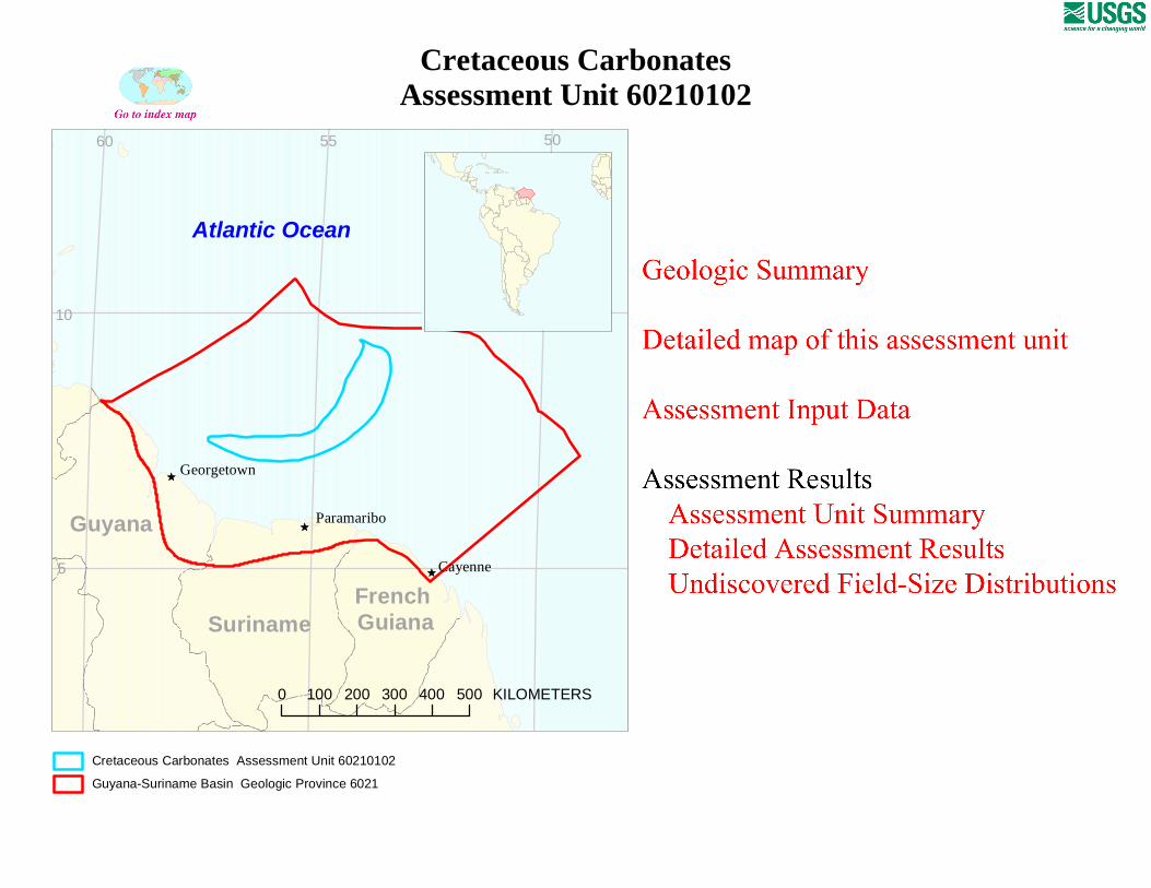
Ê Ú Ê Ú Ê Ú 0 100 200 300 400 500 KILOMETERS Cayenne Paramaribo Georgetown French Guiana Suriname Guyana Atlantic Ocean 5 10 50 55 60 Cretaceous Carbonates Assessment Unit 60210102 Guyana-Suriname Basin Geologic Province 6021 Cretaceous Carbonates Assessment Unit 60210102
Transcript
ÊÚ
ÊÚ
ÊÚ
0 100 200 300 400 500 KILOMETERS
Cayenne
Paramaribo
Georgetown
French GuianaSuriname
Guyana
Atlantic Ocean
5
10
505560
Cretaceous CarbonatesAssessment Unit 60210102
Guyana-Suriname Basin Geologic Province 6021
Cretaceous Carbonates Assessment Unit 60210102
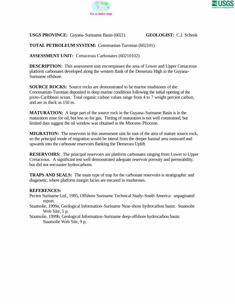
USGS PROVINCE: Guyana-Suriname Basin (6021) GEOLOGIST: C.J. Schenk TOTAL PETROLEUM SYSTEM: Cenomanian-Turonian (602101) ASSESSMENT UNIT: Cretaceous Carbonates (60210102) DESCRIPTION: This assessment unit encompasses the area of Lower and Upper Cretaceous platform carbonates developed along the western flank of the Demerara High in the Guyana-Suriname offshore. SOURCE ROCKS: Source rocks are demonstrated to be marine mudstones of the Cenomanian-Turonian deposited in deep marine conditions following the initial opening of the proto-Caribbean ocean. Total organic carbon values range from 4 to 7 weight percent carbon, and are as thick as 150 m. MATURATION: A large part of the source rock in the Guyana-Suriname Basin is in the maturation zone for oil, but less so for gas. Timing of maturation is not well constrained, but limited data suggest the oil window was obtained in the Miocene-Pliocene. MIGRATION: The reservoirs in this assessment unit lie east of the area of mature source rock, so the principal mode of migration would be lateral from the deeper basinal area eastward and upwards into the carbonate reservoirs flanking the Demerara Uplift. RESERVOIRS: The principal reservoirs are platform carbonates ranging from Lower to Upper Cretaceous. A significant test well demonstrated adequate reservoir porosity and permeability, but did not encounter hydrocarbons. TRAPS AND SEALS: The main type of trap for the carbonate reservoirs is stratigraphic and diagenetic, where platform margin facies are encased in mudstones. REFERENCES: Pecten Suriname Ltd., 1995, Offshore Suriname Technical Study–South America: unpaginated
Web Site, 5 p. Staatsolie, 1999b, Geological Information–Suriname deep-offshore hydrocarbon basin:
Staatsolie Web Site, 9 p.
60210102
60210102Assessment unitcode and boundary
6021
Assessment Unit - 60210102Cretaceous Carbonates
EXPLANATION
HydrographyShorelineGeologic province code and boundaryCountry boundaryGas field centerpointOil field centerpoint
Projection: Robinson. Central meridian: 0
50 KILOMETERS
57 56 55 54
7
8
9
Atlantic Ocean
6098
6021
SEVENTH APPROXIMATIONNEW MILLENNIUM WORLD PETROLEUM ASSESSMENTDATA FORM FOR CONVENTIONAL ASSESSMENT UNITS
Date:………………………….. 10/29/99Assessment Geologist:…….. C.J. SchenkRegion:……………………….. Central and South America Number: 6Province:……………………… Guyana-Suriname Basin Number: 6021Priority or Boutique.………… BoutiqueTotal Petroleum System:…… Cenomanian-Turonian Number: 602101Assessment Unit:…………… Cretaceous Carbonates Number: 60210102* Notes from Assessor Partial analog Campos Basin, Cretaceous Carbonates (60350102); Permian
Basin, 5044; San Andres-Clearfork, Central Basin Platform and Ozone Arch and San Andres-Clearfork, Northwestern and Eastern Shelves (U.S. plays 4411, 4410).
CHARACTERISTICS OF ASSESSMENT UNIT
Oil (<20,000 cfg/bo overall) or Gas (>20,000 cfg/bo overall):… Oil
What is the minimum field size?………. 10 mmboe grown (>1mmboe)(the smallest field that has potential to be added to reserves in the next 30 years)
Number of discovered fields exceeding minimum size:………… Oil: 0 Gas: 0 Established (>13 fields) Frontier (1-13 fields) Hypothetical (no fields) X
Median size (grown) of discovered oil fields (mmboe):1st 3rd 2nd 3rd 3rd 3rd
Median size (grown) of discovered gas fields (bcfg):1st 3rd 2nd 3rd 3rd 3rd
Assessment-Unit Probabilities: Attribute Probability of occurrence (0-1.0)1. CHARGE: Adequate petroleum charge for an undiscovered field > minimum size……………… 0.82. ROCKS: Adequate reservoirs, traps, and seals for an undiscovered field > minimum size…… 1.03. TIMING OF GEOLOGIC EVENTS: Favorable timing for an undiscovered field > minimum size 1.0
Assessment-Unit GEOLOGIC Probability (Product of 1, 2, and 3):……...…….....…. 0.8
4. ACCESSIBILITY: Adequate location to allow exploration for an undiscovered field > minimum size……………………………………………………..………………..……..………… 1.0
UNDISCOVERED FIELDS
Oil fields:…………………………………min. no. (>0) 1 median no. 25 max no. 60Gas fields:……………………………….min. no. (>0) 1 median no. 8 max no. 20
Size of Undiscovered Fields: What are the anticipated sizes (grown) of the above fields?:
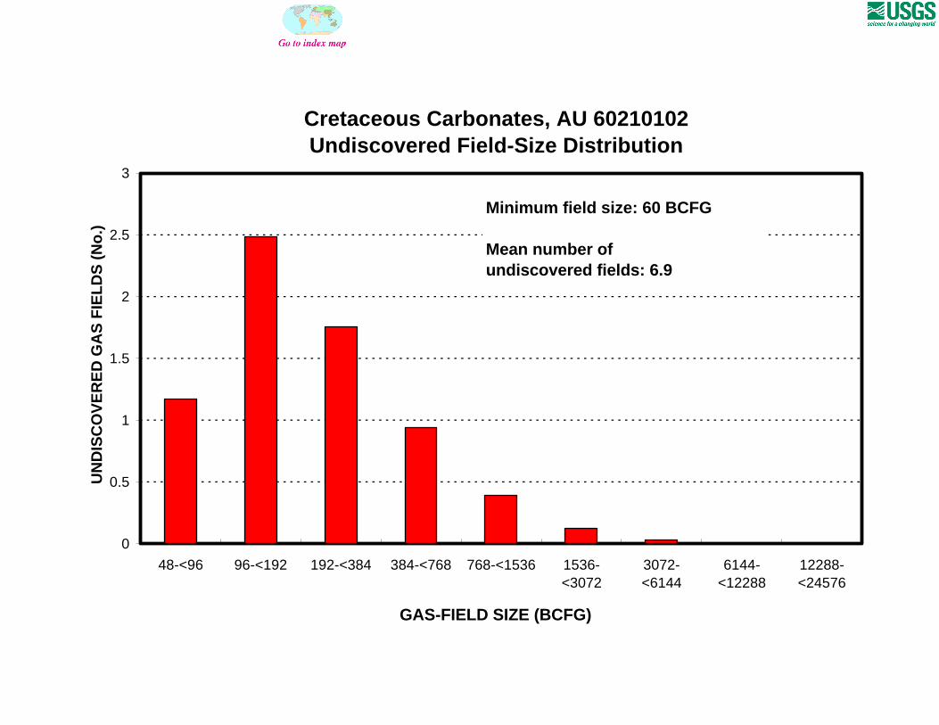
Oil in oil fields (mmbo)………………..……min. size 10 median size 45 max. size 3000Gas in gas fields (bcfg):……………………min. size 60 median size 180 max. size 6000
(variations in the sizes of undiscovered fields)
(uncertainty of fixed but unknown values)Number of Undiscovered Fields: How many undiscovered fields exist that are > minimum size?:
Page 1
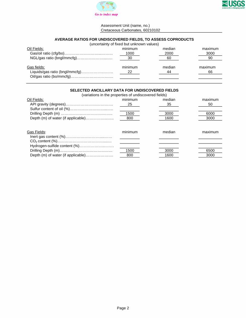
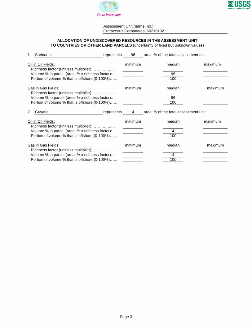
Assessment Unit (name, no.)Cretaceous Carbonates, 60210102
AVERAGE RATIOS FOR UNDISCOVERED FIELDS, TO ASSESS COPRODUCTS
Oil Fields: minimum median maximum Gas/oil ratio (cfg/bo)………………………...……… 1000 2000 3000 NGL/gas ratio (bngl/mmcfg)…………………....…. 30 60 90
Gas fields: minimum median maximum Liquids/gas ratio (bngl/mmcfg)….…………..…….. 22 44 66 Oil/gas ratio (bo/mmcfg)………………………….…
SELECTED ANCILLARY DATA FOR UNDISCOVERED FIELDS(variations in the properties of undiscovered fields)
Oil Fields: minimum median maximum API gravity (degrees)…………………….…………. 25 35 50 Sulfur content of oil (%)………………………...….. Drilling Depth (m) ……………...…………….…….. 1500 3000 6000 Depth (m) of water (if applicable)……………...….. 800 1600 3000
Gas Fields: minimum median maximum Inert gas content (%)……………………….....…… CO2 content (%)……………………………….....… Hydrogen-sulfide content (%)………………...……. Drilling Depth (m)…………………………………… 1500 3000 6500 Depth (m) of water (if applicable)…………………. 800 1600 3000
(uncertainty of fixed but unknown values)
Page 2
Assessment Unit (name, no.)Cretaceous Carbonates, 60210102
ALLOCATION OF UNDISCOVERED RESOURCES IN THE ASSESSMENT UNITTO COUNTRIES OR OTHER LAND PARCELS (uncertainty of fixed but unknown values)
1. Suriname represents 96 areal % of the total assessment unit
Oil in Oil Fields: minimum median maximum Richness factor (unitless multiplier):……….…..… Volume % in parcel (areal % x richness factor):… 96 Portion of volume % that is offshore (0-100%)…… 100
Gas in Gas Fields: minimum median maximum Richness factor (unitless multiplier):…………..…. Volume % in parcel (areal % x richness factor):… 96 Portion of volume % that is offshore (0-100%)…… 100
2. Guyana represents 4 areal % of the total assessment unit
Oil in Oil Fields: minimum median maximum Richness factor (unitless multiplier):……….…..… Volume % in parcel (areal % x richness factor):… 4 Portion of volume % that is offshore (0-100%)…… 100
Gas in Gas Fields: minimum median maximum Richness factor (unitless multiplier):…………..…. Volume % in parcel (areal % x richness factor):… 4 Portion of volume % that is offshore (0-100%)…… 100