Page 1
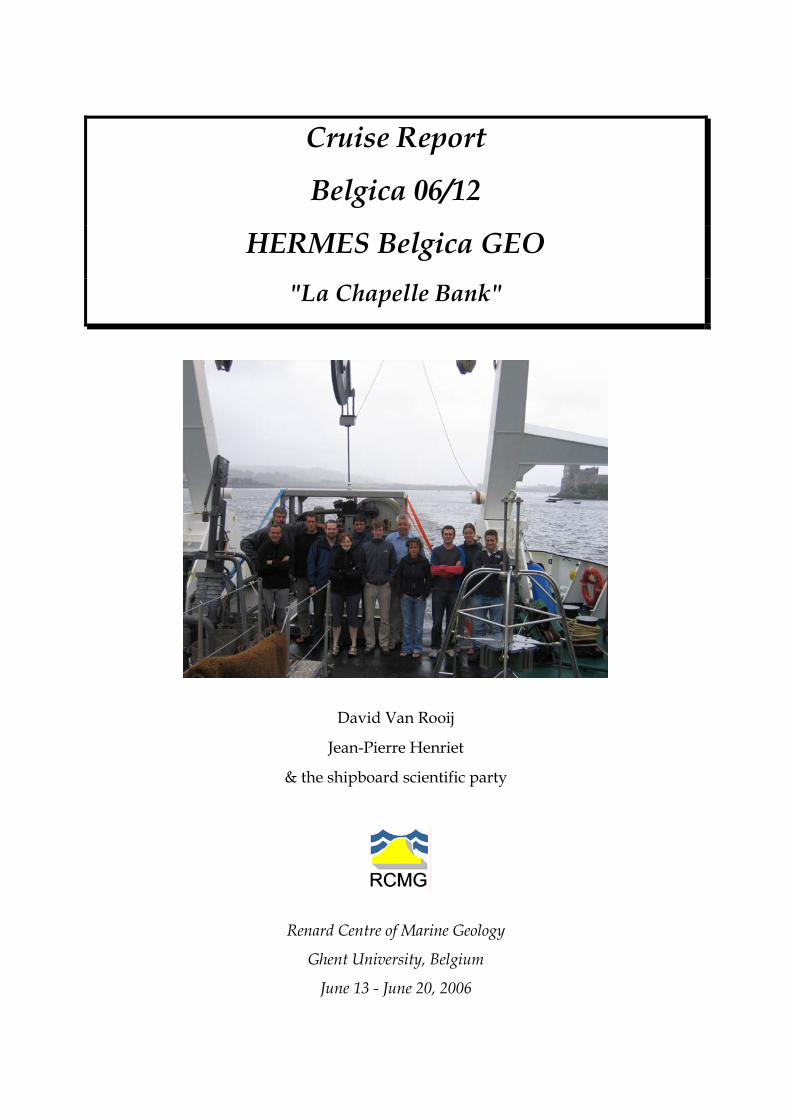
Cruise Report
Belgica 06/12
HERMES Belgica GEO "La Chapelle Bank"
David Van Rooij
Jean-Pierre Henriet
& the shipboard scientific party
Renard Centre of Marine Geology
Ghent University, Belgium
June 13 - June 20, 2006
Page 2
RCMG Cruise Report HERMES Belgica GEO La Chapelle Bank, June 2006
TABLE OF CONTENTS
1. Cruise reference......................................................................................................... 3 2. Framework and objectives.......................................................................................... 3
2.1 Framework ............................................................................................................. 3 2.2 Objectives............................................................................................................... 5
3. Departure and arrival of the cruise ............................................................................ 6 4. Working area ............................................................................................................. 6
4.1 Coordination at Sea ................................................................................................ 7 4.2 Scientific staff ......................................................................................................... 7 4.3 Operations.............................................................................................................. 7
4.3.1 Seismic survey ................................................................................................. 7 4.3.2 CTD measurements.......................................................................................... 7 4.3.3 Multibeam survey............................................................................................. 8 4.3.4 ROV survey .................................................................................................... 13 4.3.5 Operational Report ......................................................................................... 17
4.4 Operational remarks............................................................................................. 23 4.5 ROV & geological investigations: preliminary results............................................. 24
5. Class@oceans .......................................................................................................... 26 6. Data storage ............................................................................................................ 27
2
Page 3
RCMG Cruise Report HERMES Belgica GEO La Chapelle Bank, June 2006
1. Cruise reference Belgica 06/12
Brest (FR) – Cork (IRE)
13.06.2006 – 20.06.2006
Please refer to this report as:
Van Rooij, D., Henriet, J.-P. & the HERMES Belgica GEO shipboard scientific party (2006).
Cruise Report Belgica 06/12 “HERMES Belgica GEO”, "La Chapelle Bank". RCMG internal
publication, 27 pp.
2. Framework and objectives
2.1 Framework The ecological, sedimentological and geophysical research programme of the Belgica
cruise 2006/12 frames into several international and national projects:
• EC FP6 IP HERMES (2006-2008)
"Hotspot ecosystem research on the margins of European Seas" frames within the
"Global Change and Ecosystem" of the EU 6th framework programme. RCMG focuses on
geosphere controls on ecosystem hotspots in mound provinces and on the dynamic
interaction between slope sedimentary processes, carbonate mounds and coral banks.
• EU FP5 RTN EURODOM (2002-2006)
The research activities of this European Research and Training Network (RTN) are (1) the
assessment of submarine continental slope stability and (2) the investigation of the
distribution, composition, functioning and significance of deep-water carbonate mounds
and reefs. In the meantime possible relationships between both subjects are
investigated. An important role of RCMG within EURODOM is to establish a direct
satellite link between scientists on a cruise and classrooms. The class@oceans initiative
fully frames within this objective.
• ESF EUROCORES EUROMARGINS (2003-2006) project MOUNDFORCE
Study of the forcing factors controlling mound genesis and growth.
• FWO project GeNesis (2003-2006) : Gent - NEBROC II Associated project on the
Genesis of Mounds
3
Page 4
RCMG Cruise Report HERMES Belgica GEO La Chapelle Bank, June 2006
Research project on the genesis of large carbonate mounds and their precursor
phenomena, in particular those possibly related to methane seeps and authigenic
carbonate crust formation, with due emphasis on microbial mediation processes.
• Ph.D. projects of the Flemish IWT and FWO
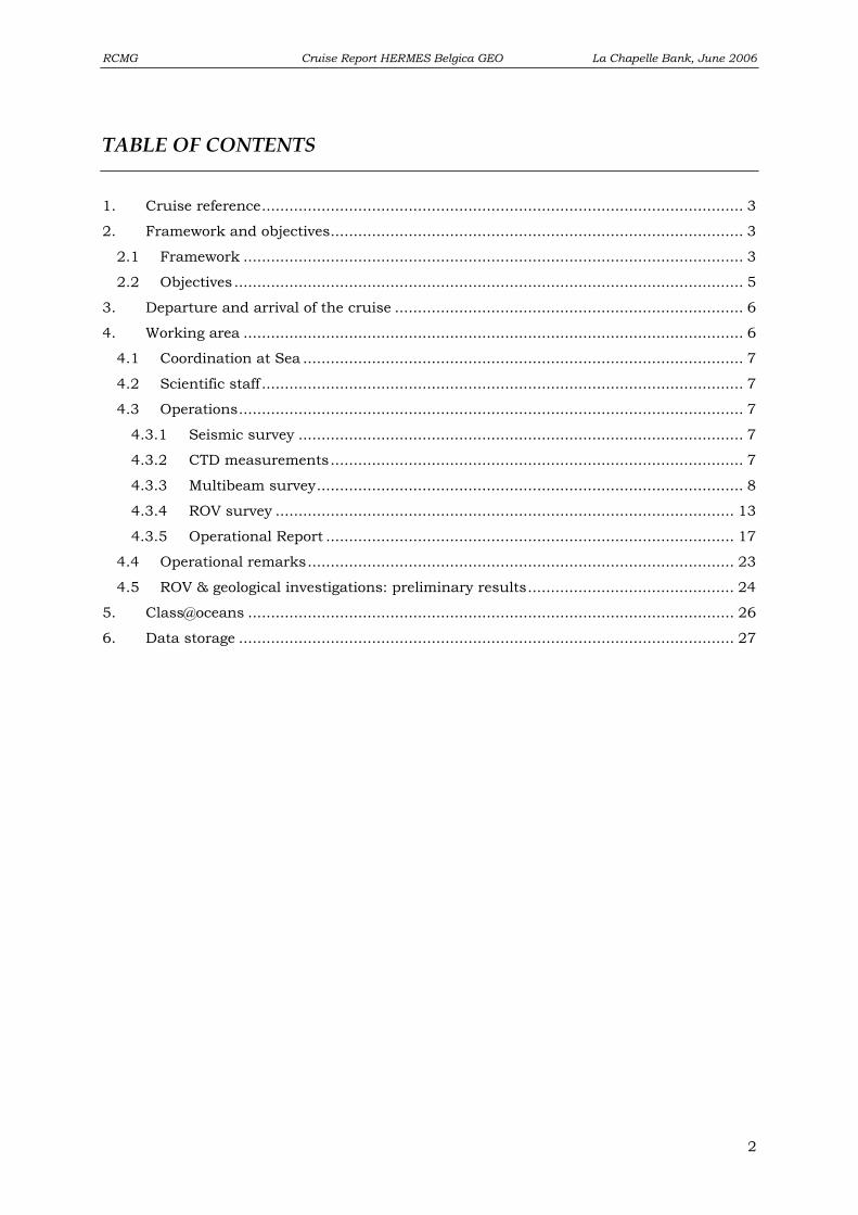
F .
igure 1: Overview map of the visited sites during R/V Belgica campaign HERMES Belgica GEO
4
Page 5
RCMG Cruise Report HERMES Belgica GEO La Chapelle Bank, June 2006
2.2 Objectives Within the framework of the EC IP FP6 HERMES project, the main RCMG objectice
was to test for the first time its ROV (Remotely Operated Vehicle) on several coral-rich sites
along the Celtic Margin and the Porcupine Basin (Fig. 1). The La Chapelle Bank (Celtic
Margin) and adjacent canyons were earlier recognized by Zibrowius and Le Danois as a
“hotspot” of deep-water corals. In the Porcupine Basin, it was planned to revisit the Moira
mounds for an extra visual reconnaissance and sampling. Also the recently discovered Enya
mounds (R/V Belgica 2003) were to be revisited for additional high-resolution seismic
profiling. Due to bad weather conditions, however, only Area 1 on La Chapelle Bank was
visited. Additionally, tests were performed in the sheltered environments of Douarnenez Bay
(France) and Bantry Bay (France).
This campaign was executed in cooperation with the department DRO-DEEP/LEP of
IFREMER (France), University College Cork (Ireland) and the National Oceanography Centre
Southampton (United Kingdom).
This campaign focused on the following topics:
• Brest & La Chapelle Bank: first testing and deployment for the ROV at the sheltered
environment of the Bay of Douarnenez. Visual observations on La Chapelle Bank were
supported with multibeam mapping and high-resolution seismic profiling.
• Bantry Bay (Ireland): ROV test dives were performed due to bad weather conditions in
the Porcupine Seabight.
.
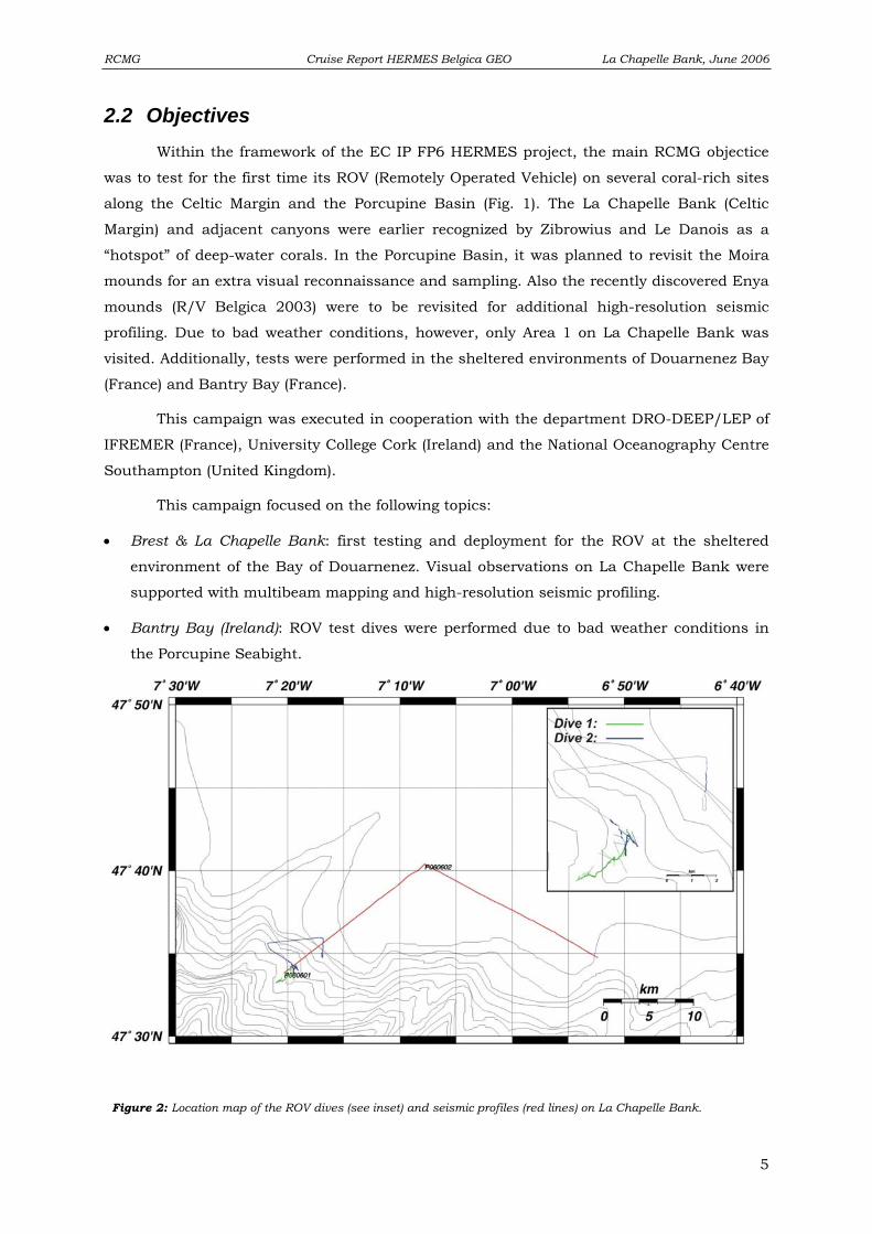
Figure 2: Location map of the ROV dives (see inset) and seismic profiles (red lines) on La Chapelle Bank
5
Page 6
RCMG Cruise Report HERMES Belgica GEO La Chapelle Bank, June 2006
3. Departure and arrival of the cruise
Belgica 06/12
Departure: Brest (FR) 14.06.2006, at 02.00h.
Arrival: Cork (IRE) 20.06.2006, at 12.00h.
4. Working area Three main working areas have been surveyed during this campaign (Fig. 1):
1. Bay of Douarnenez (Fig. 1): A first deployment was made of the TMS (Tethered
Management System) and ROV in the Bay of Douarnenez (France), due to bad
weather on La Chapelle Bank. This also included a stepwise training.
2. La Chapelle bank (Fig. 2): ROV deployment on previous dredge tracks performed
during the 1997 cruise of André Freiweld (Erlangen). A multibeam survey was
performed for morphologic support, as well as a brief seismic reconnaissance survey.
3. Bantry Bay (Fig. 1): Due to bad weather conditions in the Porcupine Seabight,
further exercises and tests were performed in the sheltered environment of Bantry
Bay (Ireland).
6
Page 7
RCMG Cruise Report HERMES Belgica GEO La Chapelle Bank, June 2006
4.1 Coordination at Sea Chief scientist: Prof. Dr. Jean-Pierre HENRIET
Renard Centre of Marine Geology (RCMG),
Ghent University, Belgium
Co-chief scientist: Dr. David Van Rooij
4.2 Scientific staff Prof. Dr. Jean-Pierre HENRIET UGent, RCMG,
Dr. David VAN ROOIJ UGent, RCMG,
Willem VERSTEEG UGent, RCMG,
Peter STAELENS UGent, RCMG,
Anneleen FOUBERT UGent, RCMG,
Dr. ir. Veerle HUVENNE NOC Southampton (UK),
Prof. Dr. Andrew WHEELER UCC (Ireland)
Erwan LE GUILLOUX IFREMER (France)
Ing. Jeroen VERCRUYSSE UGent, RCMG,
Ing. Koen DE RYCKER UGent, RCMG,
Frederik ROOSE UGent, RCMG, Marelac student,
Katja GUILINI UGent, RCMG, Marelac student
4.3 Operations
4.3.1 Seismic survey
Most of the seismic profiles are single channel surface sparker lines, acquired with a
SIG sparker source (120 electrodes). The sparker was triggered every 2 s reaching 500J
energy. The sampling frequency was set at 8 kHz and a record length of 1800 ms TWT was
used. The velocity of the ship during surface sparker seismics was maintained at about 3
knots.
4.3.2 CTD measurements
In order to obtain an up to date sound velocity profile in the multibeam survey area,
a CTD cast was taken with the aim to convert the temperature and salinity information to
sound speed values using the formula of Chen-Millero (Chen Ch.-T. & Millero, F.J. Speed of
sound in seawater at high pressures //JASA.-1977.-Vol. 62.-No 5.-P. 1129-1135.). However,
some problems were encountered during this operation. Initially the contact between the
CTD system (Seacat SBE19) and the recording PC could not be established. When finally
this problem was solved (probably by taking another configuration file (.cfg), which did not
7
Page 8
RCMG Cruise Report HERMES Belgica GEO La Chapelle Bank, June 2006
contain the plotting of the CTS’s altimeter info), and the CTD cast was taken, only the first
~50 lines of data were recorded, while the others were not, although the system had
transmitted data all throughout the cast.
As time was pressing, it was decided to use the results of a CTD cast taken during
the previous Belgica cruise in the area: ‘station 3 cast B’, which was located at 47°25'N and
7°16'W. The cast reached to over 1300 m depth, which was more than sufficient for the
purposes of the multibeam mapping. We would like to acknowledge the team of Lei Chou
and cruise ST0611A for this help to our survey.
The resulting data of this cast were saved in a binary file (.dat), and the configuration
settings were saved in the corresponding .con file. The binary data were converted to ASCII
using the program SBEDataprocessing_Win32. Only the downcast data were chosen, and
the information was binned in 2m intervals. The final file was called
‘20060615233016.asvp’, and transferred onto the UNIX station. Within a UNIX text editor, it
is necessary to delete all the windows ‘end-of-line’ characters, but after that is done, the file
could easily be entered into the Simrad software.
4.3.3 Multibeam survey
The multibeam echosounder used during this cruise is the Simrad E1002 system
from the Belgian Ministry of Economical Affairs, installed permanently on the Belgica.
Standard procedures were chosen for its application. Before leaving the port of Brest, the
draft of the ship was measured at four locations, resulting in the average value of 5.358 m.
This value was entered in the settings of the multibeam system.
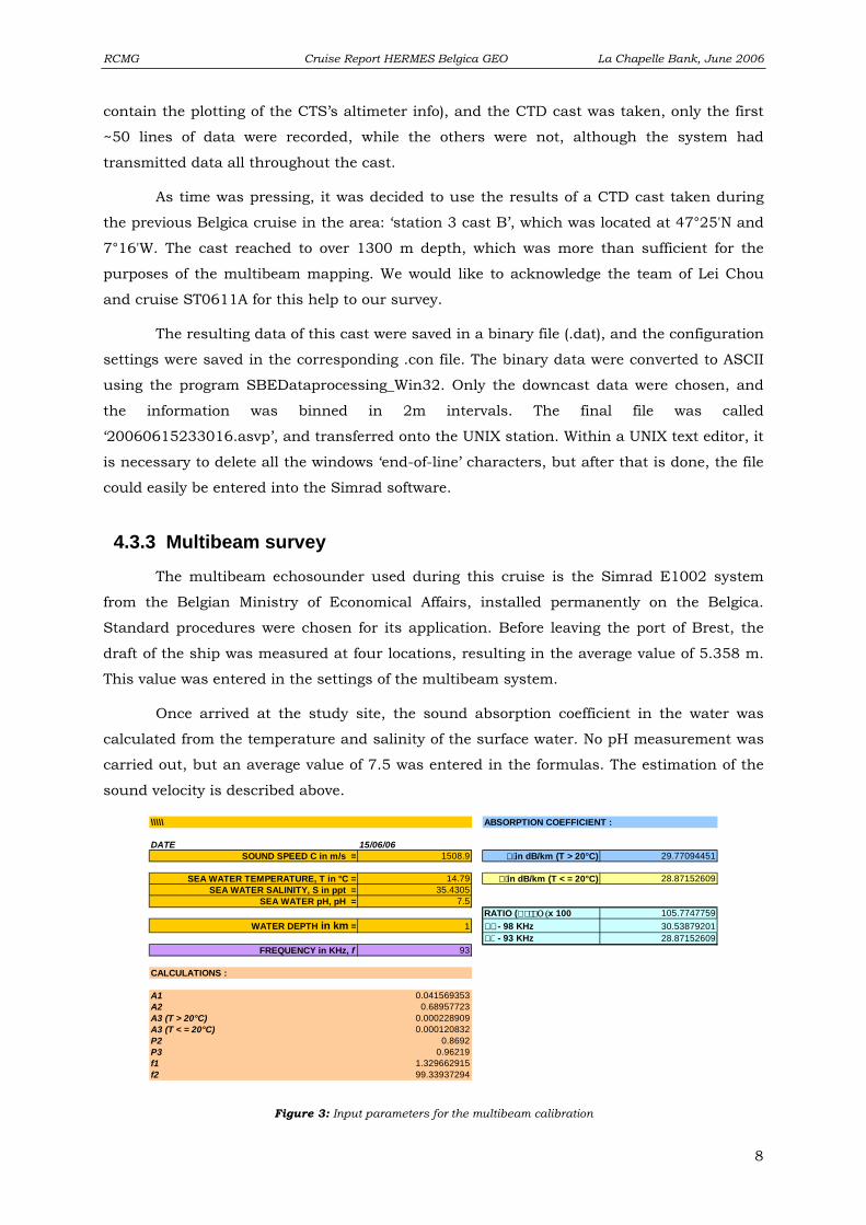
Once arrived at the study site, the sound absorption coefficient in the water was
calculated from the temperature and salinity of the surface water. No pH measurement was
carried out, but an average value of 7.5 was entered in the formulas. The estimation of the
sound velocity is described above.
\\\\\ ABSORPTION COEFFICIENT :
DATE 15/06/06SOUND SPEED C in m/s = 1508.9 in dB/km (T > 20°C) 29.77094451
SEA WATER TEMPERATURE, T in °C = 14.79 in dB/km (T < = 20°C) 28.87152609SEA WATER SALINITY, S in ppt = 35.4305
SEA WATER pH, pH = 7.5RATIO ( Ο (x 100 105.7747759
WATER DEPTH in km = 1 - 98 KHz 30.53879201 - 93 KHz 28.87152609
FREQUENCY in KHz, f 93
CALCULATIONS :
A1 0.041569353A2 0.68957723A3 (T > 20°C) 0.000228909A3 (T < = 20°C) 0.000120832P2 0.8692P3 0.96219f1 1.329662915f2 99.33937294
Figure 3: Input parameters for the multibeam calibration
8
Page 9
RCMG Cruise Report HERMES Belgica GEO La Chapelle Bank, June 2006
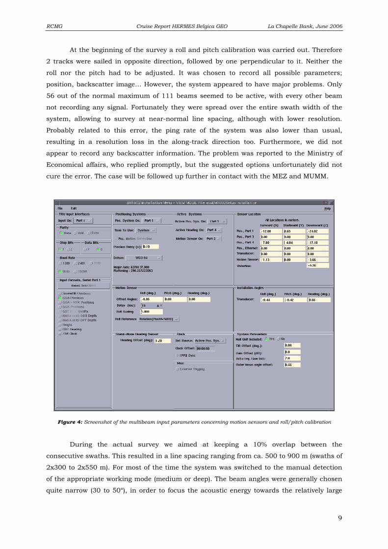
At the beginning of the survey a roll and pitch calibration was carried out. Therefore
2 tracks were sailed in opposite direction, followed by one perpendicular to it. Neither the
roll nor the pitch had to be adjusted. It was chosen to record all possible parameters;
position, backscatter image… However, the system appeared to have major problems. Only
56 out of the normal maximum of 111 beams seemed to be active, with every other beam
not recording any signal. Fortunately they were spread over the entire swath width of the
system, allowing to survey at near-normal line spacing, although with lower resolution.
Probably related to this error, the ping rate of the system was also lower than usual,
resulting in a resolution loss in the along-track direction too. Furthermore, we did not
appear to record any backscatter information. The problem was reported to the Ministry of
Economical affairs, who replied promptly, but the suggested options unfortunately did not
cure the error. The case will be followed up further in contact with the MEZ and MUMM.
Figure 4: Screenshot of the multibeam input parameters concerning motion sensors and roll/pitch calibration
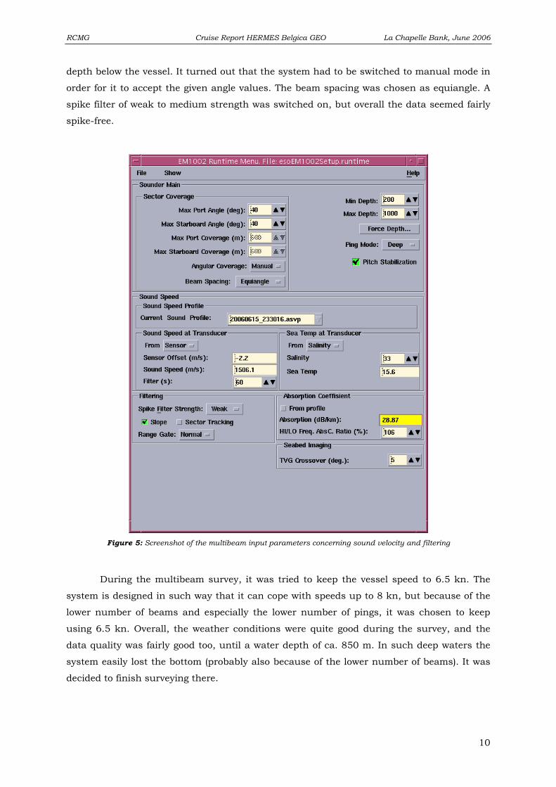
During the actual survey we aimed at keeping a 10% overlap between the
consecutive swaths. This resulted in a line spacing ranging from ca. 500 to 900 m (swaths of
2x300 to 2x550 m). For most of the time the system was switched to the manual detection
of the appropriate working mode (medium or deep). The beam angles were generally chosen
quite narrow (30 to 50°), in order to focus the acoustic energy towards the relatively large
9
Page 10
RCMG Cruise Report HERMES Belgica GEO La Chapelle Bank, June 2006
depth below the vessel. It turned out that the system had to be switched to manual mode in
order for it to accept the given angle values. The beam spacing was chosen as equiangle. A
spike filter of weak to medium strength was switched on, but overall the data seemed fairly
spike-free.
Figure 5: Screenshot of the multibeam input parameters concerning sound velocity and filtering
During the multibeam survey, it was tried to keep the vessel speed to 6.5 kn. The
system is designed in such way that it can cope with speeds up to 8 kn, but because of the
lower number of beams and especially the lower number of pings, it was chosen to keep
using 6.5 kn. Overall, the weather conditions were quite good during the survey, and the
data quality was fairly good too, until a water depth of ca. 850 m. In such deep waters the
system easily lost the bottom (probably also because of the lower number of beams). It was
decided to finish surveying there.
10
Page 11
RCMG Cruise Report HERMES Belgica GEO La Chapelle Bank, June 2006
Additionally, towards the end of the cruise, the ship had to seek refuge into Bantry
Bay (Ireland). Upon entering the bay, it was decided to keep the multibeam running, in
order to obtain a rough idea of the morphology of the seabed, and to judge if it would be a
suitable environment for any further ROV tests in the area. The system was set to slightly
different parameters. A constant sound velocity profile of 1496 m/s was chosen, as no CTD
cast was taken. The ping mode was set to shallow, the beam spacing to equidistant, with
maximal coverage of 75° at either side. The TVG cross-over was increased to 10 (following
advice given by the Marine Institute in Galway, based on their experience during the
National Seabed Survey). The absorption coefficient was 106, with 31.04 the coefficient for
93 kHz. Finally the weak anti-spike filter was kept active.
At the end of the survey, all the data were backed up on external hard drive (via ftp
from the Sun workstation to the Belgica laptop, including both the raw data files and the
proc files). The data were left on the system for the MEZ and MUMM as illustration of the
problems encountered.
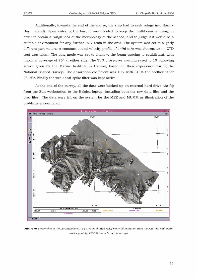
Figure 6: Screenshot of the La Chapelle survey area in shaded relief mode (illumination from the NE). The multibeam
tracks (mainly NW-SE) are indicated in orange
11
Page 12
RCMG Cruise Report HERMES Belgica GEO La Chapelle Bank, June 2006
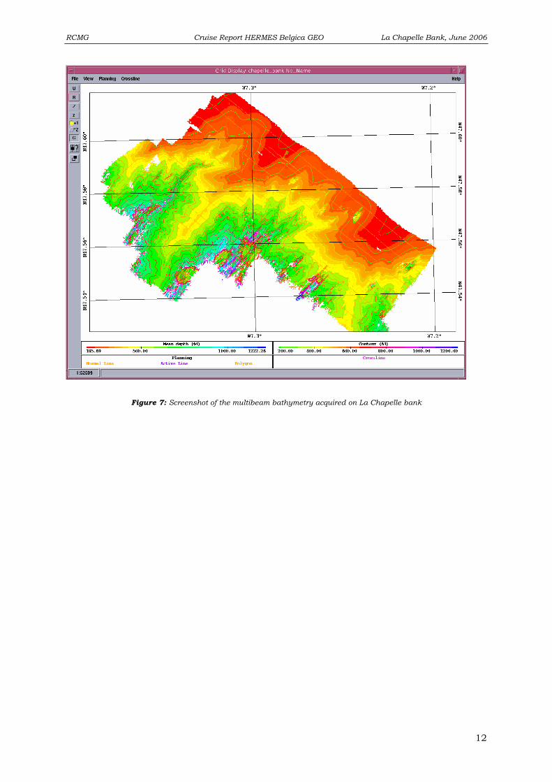
Figure 7: Screenshot of the multibeam bathymetry acquired on La Chapelle bank
12
Page 13
RCMG Cruise Report HERMES Belgica GEO La Chapelle Bank, June 2006
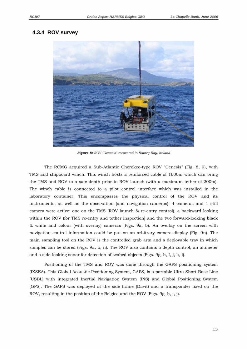
4.3.4 ROV survey
The RCMG acquired a Sub-Atlantic Cherokee-type ROV "Genesis" (Fig. 8, 9), with
TMS and shipboard winch. This winch hosts a reinforced cable of 1600m which can bring
the TMS and ROV to a safe depth prior to ROV launch (with a maximum tether of 200m).
The winch cable is connected to a pilot control interface which was installed in the
laboratory container. This encompasses the physical control of the ROV and its
instruments, as well as the observation (and navigation cameras). 4 cameras and 1 still
camera were active: one on the TMS (ROV launch & re-entry control), a backward looking
within the ROV (for TMS re-entry and tether inspection) and the two forward-looking black
& white and colour (with overlay) cameras (Figs. 9a, b). An overlay on the screen with
navigation control information could be put on an arbitrary camera display (Fig. 9n). The
main sampling tool on the ROV is the controlled grab arm and a deployable tray in which
samples can be stored (Figs. 9a, b, n). The ROV also contains a depth control, an altimeter
and a side-looking sonar for detection of seabed objects (Figs. 9g, h, I, j, k, l).
Positioning of the TMS and ROV was done through the GAPS positioning system
(IXSEA). This Global Acoustic Positioning System, GAPS, is a portable Ultra Short Base Line
(USBL) with integrated Inertial Navigation System (INS) and Global Positioning System
(GPS). The GAPS was deployed at the side frame (Davit) and a transponder fixed on the
ROV, resulting in the position of the Belgica and the ROV (Figs. 9g, h, i, j).
Figure 8: ROV "Genesis" recovered in Bantry Bay, Ireland
13
Page 14
RCMG Cruise Report HERMES Belgica GEO La Chapelle Bank, June 2006
Fig. 9a Fig. 9b
Fig. 9c Fig. 9d
Fig. 9e Fig. 9f
Fig. 9g Fig. 9h
14
Page 15
RCMG Cruise Report HERMES Belgica GEO La Chapelle Bank, June 2006
Fig. 9i Fig. 9j
Fig. 9k Fig. 9l
Fig. 9m Fig. 9n
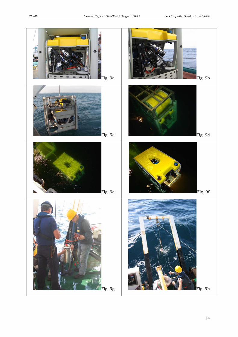
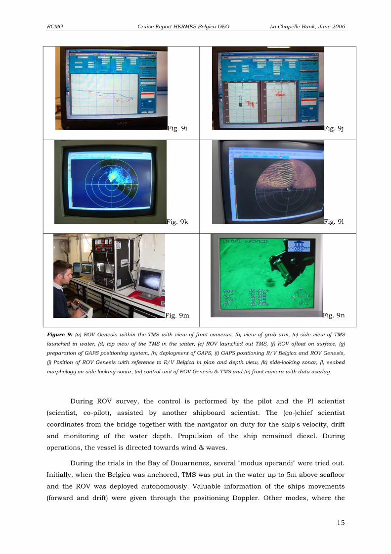
Figure 9: (a) ROV Genesis within the TMS with view of front cameras, (b) view of grab arm, (c) side view of TMS
launched in water, (d) top view of the TMS in the water, (e) ROV launched out TMS, (f) ROV afloat on surface, (g)
preparation of GAPS positioning system, (h) deployment of GAPS, (i) GAPS positioning R/V Belgica and ROV Genesis,
(j) Position of ROV Genesis with reference to R/V Belgica in plan and depth view, (k) side-looking sonar, (l) seabed
morphology on side-looking sonar, (m) control unit of ROV Genesis & TMS and (n) front camera with data overlay.
During ROV survey, the control is performed by the pilot and the PI scientist
(scientist, co-pilot), assisted by another shipboard scientist. The (co-)chief scientist
coordinates from the bridge together with the navigator on duty for the ship's velocity, drift
and monitoring of the water depth. Propulsion of the ship remained diesel. During
operations, the vessel is directed towards wind & waves.
During the trials in the Bay of Douarnenez, several "modus operandi" were tried out.
Initially, when the Belgica was anchored, TMS was put in the water up to 5m above seafloor
and the ROV was deployed autonomously. Valuable information of the ships movements
(forward and drift) were given through the positioning Doppler. Other modes, where the
15
Page 16
RCMG Cruise Report HERMES Belgica GEO La Chapelle Bank, June 2006
Belgica was not at anchor, did involve a near-stationary mode or drift. Unfortunately, the
Doppler readings were not working properly from than on, so no accurate information was
available about the speed and (sideward) drift. Here, TMS was positioned at 10m above
seafloor with about 30m of tether towards the ROV. Gentle drift (0.5 knots) of the Belgica
towed TMS and ROV. Navigation of ROV and observation was done through its rear-looking
camera. For detailed observation or sampling, more tether was given to the ROV and the
ship's speed was slowed down. An alternative mode consisted in manoeuvring the ROV
underneath the TMS, flying at the same course and speed than R/V Belgica. This method
was abandoned since it was too complicated.
Start dive End dive Dive name Date Location
Time Depth Time Depth
B06-01 Test 14/06/06 Bay of Douarnenez (FR) 15:00 18m 16:30 20m
B06-02 Test 14/06/06 Bay of Douarnenez (FR) 17:15 20m 22:30 20m
B06-03 Test 15/06/06 Bay of Douarnenez (FR) 08:44 31m 10:05 31m
B06-04 Test 15/06/06 Bay of Douarnenez (FR) 10:15 31m 11:30 31m
B06-lachap-1 16/06/06 La Chapelle Banc 09:27 282m 10:33 282m
B06-lachap-1bis 16/06/06 La Chapelle Banc 15:10 485m 16:00 475m
B06-lachap-1tris 16/06/06 La Chapelle Banc 16:44 400m 20:05 400m
B06-lachap-2 17/06/06 La Chapelle Banc 09:55 587m 18:44 557m
B06-bantry-1 19/06/06 Bantry Bay, Bear Island 08:43 37m 09:35 37m
B06-bantry-2 19/06/06 Bantry Bay, South cliff 10:20 25m 13:05 30m
B06-bantry-3 19/06/06 Bantry Bay, propeller insp. 15:09 - 15:45 -
B06-bantry-4 19/06/06 Bantry Bay, Doonby Head 17:22 40m 19:31 40m
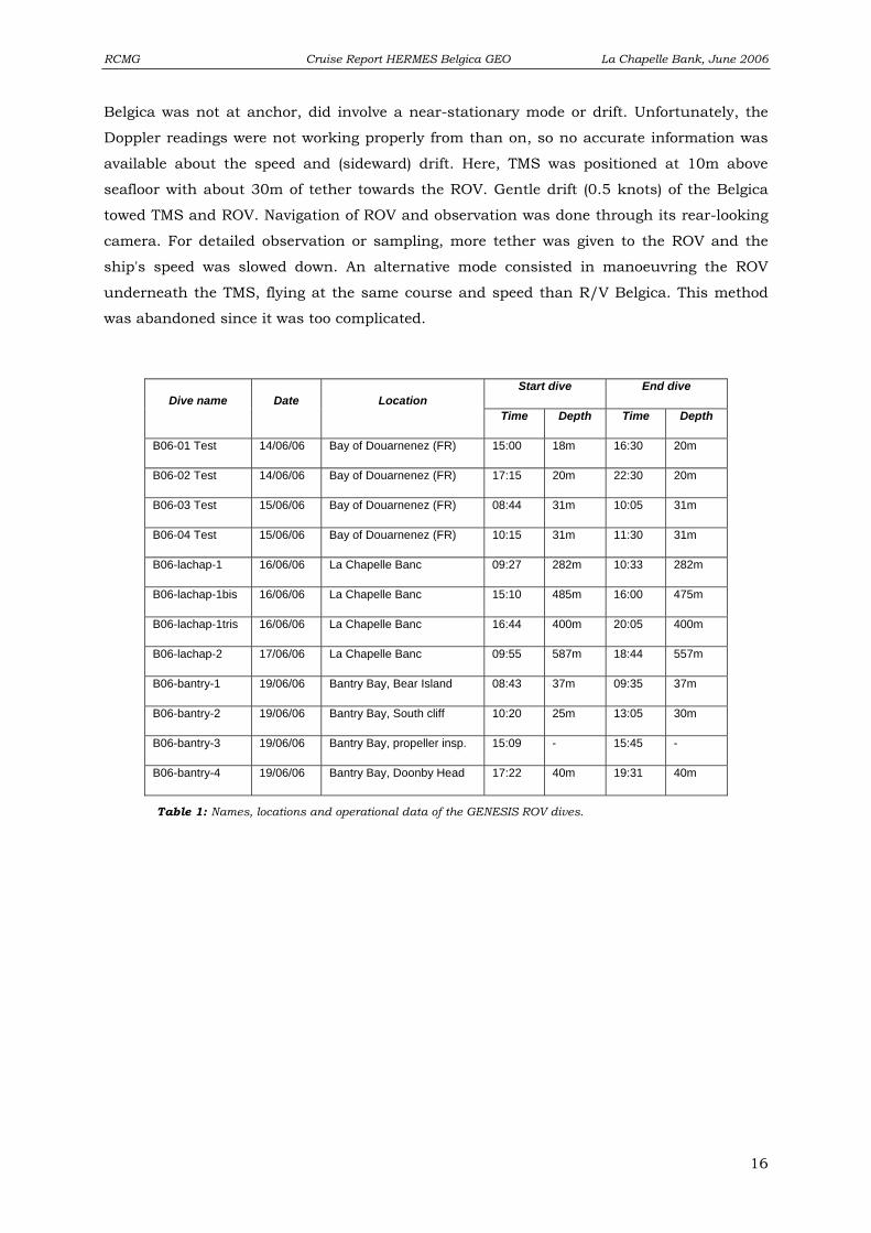
Table 1: Names, locations and operational data of the GENESIS ROV dives.
16
Page 17
RCMG Cruise Report HERMES Belgica GEO La Chapelle Bank, June 2006
4.3.5 Operational Report
It is worth noting that the time used in this cruise report and on the seismic survey
sheets is the Belgian Summer time (BRAVO TIME = UTC+2hours). Multibeam files were
acquired in GMT time.
Friday 09.06.2006
20:00 Arrival of a part of the technical team in Brest (Koen De Rycker & Willem Versteeg)
Saturday 10.06.2006 12:00 Arrival of R/V Belgica in the port of Brest
13:00 Start of mobilisation of ROV and seismic equipment on R/V Belgica
Sunday 11.06.2006 07:00 Start of installation and testing of ROV, with assistance of a Sub-Atlantic engineer
19:30 Arrival of shipboard scientific crew from Gent (Jean-Pierre Henriet, David Van Rooij,
Anneleen Foubert, Peter Staelens, Jeroen Vercrussye, Katja Guilini and Frederik
Roose).
20:30 Arrival of Veerle Huvenne
Monday 12.06.2006
08:30 Further installation and testing of the ROV equipment, installation of seismic survey
equipment and testing of satellite link for the Class@oceans live-stream
transmission.
16:00 Malfunction of fibre-optic cables of the ROV is detected.
17:30 Arrival of Andrew Wheeler (UCC, Cork) and Erwan Le Guilloux (IFREMER)
Tuesday 13.06.2006
09:00 Reparation of the fibre-optic connections and further testing of the ROV equipment.
The departure of R/V Belgica is postponed, dependant of the progress of the
reparation work. The testing of satellite link for the Class@oceans live-stream
transmission was successfully continued with Belgian and German classes.
21:00 Scientific briefing
22:00 All ROV systems are working and an immersion test is successfully made. Only the
latch-lock system is not working properly. A last check is performed to ensure all
material is secured for seagoing.
Wednesday 14.06.2006 Meteo: NE 'ly 15-20 knots in a general clear and dry weather. A swell (1.5-2m) was present
in the study area.
17
Page 18
RCMG Cruise Report HERMES Belgica GEO La Chapelle Bank, June 2006
02:00 Departure of R/V Belgica towards Area 1: La Chapelle bank
08:00 Due to an unfavourable seastate (4-5 beaufort), the transit to La Chapelle bank is
aborted and it was decided to do ROV manipulation exercises in the sheltered
environment of the Douarnenez Bay. Exact working zone has to be decided in
cooperation with R/V Thalia of IFREMER and with the navy post at Cap de la
Chèvre.
14:00 Anchoring at site 13 (48°12.292' N 004°28.719' W), with a water depth between 18
and 20m
14:15 Testing and performing checklist of ROV and deploying GAPS positioning equipment.
Testing and set-up of Class@Oceans transmission with the German class
15:00 Start of B06-01 Test. TMS and ROV are put in the water to a depth of 5m above sea
floor. At the same time, the Class@Oceans transmission was performed, where
scientists answered questions of the German students on corals and the campaign
15:15 The ROV is launched and starts its first seabed survey
16:30 End of B06-01 Test. The ROV is brought back into the TMS and winched on deck for
small adjustments and check of the sampling trials.
17:15 Start of B06-02 Test. Second ROV deployment for manoeuvring exercises by pilots
and co-pilots.
21:15 Extensive testing of the ROV system has proven the buoyancy of the tether cable is
not sufficient to prevent touching of the sea floor. Seen the extensive coral settling in
Porcupine Seabight, this might damage the present ecosystem and also the tether.
Therefore, it is preferred to first continue testing and make within the La Chapelle
bank area first observation dives.
22:30 End of B06-02 Test. TMS & ROV are brought back on deck and rinsed with fresh
water
Thursday 15.06.2006 Meteo: NE 'ly 15-20 knots in a general clear and dry weather. A gentle swell (0.5-1.0m) was
present in the study area with sea state 3 to 4.
08:00 Anchor in of R/V Belgica, diesel engine propulsion
08:30 GAPS positioning system is deployed from side frame (Davit)
08:40 Start of B06-03 Test. TMS & ROV in the water, winched down up to 10m above
seafloor (31m water depth)
08:45 ROV out TMS, 50m of tether
09:00 First test sampling site, ROV is on seafloor
09:30 Testing of positioning with sideward thrusters. Forward speed at maximum of 0.5
knots
18
Page 19
RCMG Cruise Report HERMES Belgica GEO La Chapelle Bank, June 2006
09:55 Docking of ROV in TMS, recovery on deck. This in order to solve positioning
problems with GAPS. End of B06-03 Test
10:05 Start of B06-04 Test. TMS & ROV back in the water, winched down up to 10m above
seafloor (31m water depth)
10:17 Booting problems with GAPS
10:18 Trial of new configuration; ROV sails autonomously at a heading of 096°
11:02 GAPS has been relocated, positioning problem is solved
11:30 ROV is docked in TMS and brought on deck; end of B06)04 Test. Transit to La
Chapelle bank
22:55 Arrival at CTD site (47°32.517'N 7°21.611'W)
22:59 CTD back on board; malfunctioning. CTD data is taken from previous campaign.
Transit towards first multibeam point
Friday 16.06.2006 Meteo: Easterly wind in a general clear and dry weather. A gentle swell (0.5-1.0m) was
present in the study area with sea state 4.
01:41 Start of multibeam calibration line 1 (heading 30°)
01:53 End of multibeam calibration line 1
02:00 Start of multibeam calibration line 2
02:21 End of multibeam calibration line 2
02:27 Start of multibeam calibration line 3
02:38 End of multibeam calibration line 3
03:03 Start of multibeam line 4 (heading 140°), only 50% of the beams are working
04:00 End of multibeam line 4
04:05 Start of multibeam line 5 (heading 310°)
04:53 End of multibeam line 5
04:57 Start of multibeam line 6 & 7(heading 140°)
05:59 End of multibeam line 6 & 7
06:04 Start of multibeam line 8 (heading 310°)
06:51 End of multibeam line 8
06:55 Start of multibeam line 9 (heading 140°)
07:52 End of multibeam line 9, end of multibeam survey
08:30 Preparation and testing of ROV equipment. Special "cocos" mats are laid at the floor
of the rear part of the aft deck
09:20 GAPS positioning in the water
09:23 Start of B06-lachap-1. TMS & ROV in the water (282m water depth), winching down
to 40m above sea floor
09:44 Compensation alarm on ROV at 20m below sea level.
10:28 ROV & TMS back on deck for reparations. End of B06-lachap-1
19
Page 20
RCMG Cruise Report HERMES Belgica GEO La Chapelle Bank, June 2006
11:30 Transit towards multibeam area for additional lines (while ROV is repaired)
12:06 Start of multibeam line 10 & 11 (heading 306°)
13:09 End of multibeam line 10 & 11
13:20 Start of multibeam line 12, line n° jumped back to n°1 (heading 133°)
13:52 End of multibeam line 1 (12)
14:20 Start of multibeam line 2 (heading 310°)
14:29 End of multibeam line 2
14:31 Start of multibeam line 3 (heading 133°)
14:55 End of multibeam line 3, end of multibeam survey, transit towards 2nd ROV dive site
15:10 Start of B06-lachap-1bis. GAPS and TMS & ROV back in the water (water depth
485m)
15:40 New ROV track, due south
15:46 TMS & ROV are winched up again; one of the recovery ropes attached to the TMS
has loosened and problem with the ROV latch. End of B06-lachap-1bis.
16:42 Start of B06-lachap-1tris. TMS & ROV back in the water to a water depth of 400m
on a N-S downslope transect
17:24 ROV has reached end of station point, continued due south
17:31 Southern drift, 180° with speed 0.5 knots, ROV out TMS
17:38 ROV on sea floor
19:28 ROV needs to be winched up; problem with tether cable
19:45 ROV & TMS on deck; drift robe and fisheries cable was attached to frame
20:05 End of B06-lachap-1tris
20:17 Start of new multibeam survey, new line number, start of multibeam line 1 (heading
310°)
20:38 End of multibeam line 1
20:40 Start of multibeam line 2 (heading 220°)
20:52 End of multibeam line 2
20:53 Start of multibeam line 3 (heading 120°)
21:19 End of multibeam line 3
21:25 Start of multibeam line 4 (heading 312°)
21:40 End of multibeam line 4
21:46 Start of multibeam line 5 (heading 122°)
22:02 End of multibeam line 5
22:09 Start of multibeam line 6 & 7 (heading 220°)
22:20 End of multibeam line 6 & 7, end of multibeam survey
22:25 Preparation of seismic survey, switch to electric propulsion
22:46 Start of line P060601, heading 49° (av. speed 2.4 knots)
20
Page 21
RCMG Cruise Report HERMES Belgica GEO La Chapelle Bank, June 2006
Saturday 17.06.2006 Meteo: Easterly wind in a general clear and dry weather. A gentle swell (0.5m) was present
in the study area with sea state 3.
00:03 Change of course for line P060601, heading 130°
02:34 End of line P060601
02:45 Start of line P060602, heading 63° (av. speed 3.0 knots)
06:47 End of line P060602, end of seismic survey, transit back to La Chapelle diving area
09:45 GAPS in water
09:50 Start of B06-lachap-2. TMS & ROV in water
18:44 End of B06-lachap-2. TMS & ROV on deck
19:15 Start transit to Porcupine Seabight
Sunday 18.06.2006 Meteo: Westerly wind in a cloudy dry weather. A swell (1.0-1.5m) was present with sea state
5 to 6.
16:10 Transit to Porcupine Seabight was aborted due to bad weather. Change of course
towards Bantry Bay for shelter.
21:00 Anchored in Bantry Bay (South of Bear Island)
Monday 19.06.2006
Meteo: Westerly wind in a cloudy dry weather. A swell of approximately 1.0m was present in
the study area with sea state 4. However, within the open ocean, gale warnings (state 8)
were given.
08:30 R/V Belgica remains anchored during first ROV deployment in Bantry Bay (37m
water depth). Pre-dive testing and checklist.
08:43 Start of B06-bantry-1. TMS & ROV are deployed
08:45 GAPS is deployed and launch of ROV
09:05 ROV back in TMS
09:35 Recovery of TMS & ROV, end of B06-bantry-1. Transit to southern edge of Bantry
Bay, to perform a E-W cliff transect towards Sheep's Head
10:10 Arrival at site (transect between Glanrooncoosh and Coosbrach)
10:15 Start of B06-bantry-2. TMS & ROV are deployed (water depth of 24.5m)
10:22 Launch of ROV
12:55 ROV back in TMS
13:05 Recovery of TMS & ROV; end of B06-bantry-2. Transit to southern area of Bear
Island near Doonby Head
13:59 TMS & ROV are deployed
21
Page 22
RCMG Cruise Report HERMES Belgica GEO La Chapelle Bank, June 2006
14:06 R/V Belgica suffers from propeller problem. TMS & ROV are recovered
instantaneously on deck and are inspected. Most probably an illegal fisher's net was
mixed up in the propeller.
14:10 Transit of R/V Belgica to safe position for anchoring. ROV inspection of the propeller.
15:00 Anchored for Bear Island
15:09 Start of B06-bantry-3. TMS & ROV are deployed to a depth of 5m beneath sea level
15:14 Launch of ROV, start of visual inspection of propeller
15:30 A fisher's net has indeed been mixed up around the propeller shaft. However, no
clear visible damage is noticed
15:45 Recovery of TMS & ROV, end of B06-bantry-3. Transit to Doonby Head survey site
17:17 Arrival at ROV survey site
17:22 Start of B06-bantry-4. TMS & ROV are deployed
17:25 GAPS is deployed
18:45 Malfunctioning of tether in/out function on the TMS
19:00 TMS is recovered on deck to detect (mechanical) problem
19:20 GAPS is recovered
19:25 Zodiac in the water for ROV recovery with use of the shipboard crane
19:31 ROV is recovered, end of B06-bantry-4. Disconnecting ROV from TMS
20:00 R/V Belgica is anchored, re-arrangement of aft deck and preparation for transit
24:00 Departure of R/V Belgica to Cork (Ireland)
Tuesday 20.06.2006
08:30 Approach toward Cork harbour entry at Cobh
09:00 Webcam transmission of class@oceans with the Belgian class
10:30 Pick-up of pilot
12:00 R/V Belgica is berthed in Cork, end of campaign ST06/12
13:00 Demobilisation of RCMG material and dismantlement of the TMS connection
14:00 Arrival of Irish Navy divers team to inspect and clear the ship's propeller. Because
the Irish Navy also seems to use a Sub-Atlantic Cherokee ROV, further contacts were
made.
18:00 Reception on board of R/V Belgica
Wednesday 21.06.2006
08:30 Departure of RCMG shipboard scientific crew, except for David Van Rooij and Willem
Versteeg who will stay for the duration of campaign ST0613
11:00 Pick-up of TMS which will be transported to Sub-Atlantic (Aberdeen, Scotland) for
reparations
22
Page 23
RCMG Cruise Report HERMES Belgica GEO La Chapelle Bank, June 2006
Thursday 22.06.2006
12:30 Visit of staff members of the Irish Navy Diving unit for further information exchange
on the use and operation of the Sub-Atlantic Cherokee ROV
4.4 Operational remarks First of all, we want to thank the captain and crew for their tremendous efforts and
the fine cooperation for this campaign. The on-board skilfulness really contributed greatly to
this first ROV campaign. In view of a better cooperation during future ROV campaigns, we
would like to formulate some suggestions which could stimulate more success:
• During the first trials in the Bay of Douarnenez, the use of the Doppler log was
proven very valuable. However, from the moment the ship is moving, and
certainly into deeper waters, the readings become unreliable. For ROV work (but
possibly also for coring purpose), it would be easier to navigate when knowing
the movements of the ship, as well for the ROV pilots, as well for the navigation.
• Also during ROV operations, an accurate depth reading is necessary since no
altimeter is present on the TMS. However, the depth reading from the FURUNO
echosounder is not always reliable and difficult to interpret in depths greater
than 300m. It would be interesting if accurate depth readings (up to 1500m) were
immediately available for the navigation on the bridge (which could be relayed
through the scientists through the ship's intranet). This could also be of great
importance for deep-water sampling.
• During this campaign a lot of positions for tracks or stations were needed. Most
of these were changed or added during the campaign. The present way of
submission of coordinates has proven to be very time-consuming for the
scientists and the navigational staff. Unfortunately this manual input of
coordinates also is a source of errors (The dd°mm,mm' format is not easily
exported. We believe a lot of time and effort would be saved if coordinates of
tracks and stations could be submitted in a digital format (text files with decimal
coordinate values) to be uploaded in the Transas programme.
23
Page 24
RCMG Cruise Report HERMES Belgica GEO La Chapelle Bank, June 2006
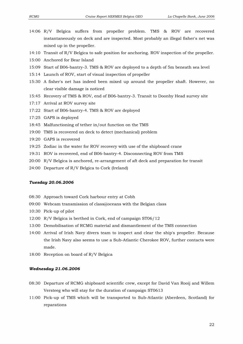
4.5 ROV & geological investigations: preliminary results
The French canyon system near the Banc de la Chapelle offered a perfect location for
rigorous trials of GENESIS: reported cold-water coral finds, rugged topography and
hydrodynamics in a setting linking the shelf seas to the deep marine realm. The area was
first surveyed using R/V Belgica’s multibeam echosounder, imaging deep canyons and
thalweg channels between prominent spurs where corals had been reported (Fig. 7). Seismic
lines provided a geological context and linked in to the existing seismostratigraphy (Fig. 10).
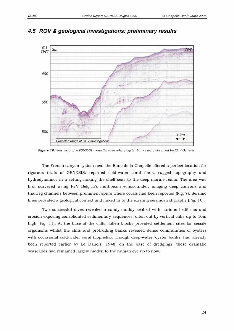
Two successful dives revealed a sandy-muddy seabed with curious bedforms and
erosion exposing consolidated sedimentary sequences, often cut by vertical cliffs up to 10m
high (Fig. 11). At the base of the cliffs, fallen blocks provided settlement sites for sessile
organisms whilst the cliffs and protruding banks revealed dense communities of oysters
with occasional cold-water coral (Lophelia). Though deep-water ‘oyster banks’ had already
been reported earlier by Le Danois (1948) on the base of dredgings, these dramatic
seascapes had remained largely hidden to the human eye up to now.
Figure 10: Seismic profile P060601 along the area where oyster banks were observed by ROV Genesis
24
Page 25
RCMG Cruise Report HERMES Belgica GEO La Chapelle Bank, June 2006
Figure 11: Camera stills from the ROV Genesis observations on La Chapelle Banc.
25
Page 26
RCMG Cruise Report HERMES Belgica GEO La Chapelle Bank, June 2006
5. Class@oceans Class@oceans (http://www.vliz.be/projects/classatoceans/index.htm) has the aim
to bring marine sciences straightforward into classrooms or to bring the marine world to the
youth. It gives students the opportunity to discover the oceans together with scientists. In a
first step two classes (Koninklijk Atheneum Gent (B) and the Maria-von-Lindenschule,
Heidenheim (D)) were brought into contact with each other by a website-concept (in
cooperation with VLIZ). The second step was to introduce the classes into the concept of a
scientific campaign with a research vessel (R/V Belgica) and the scientific background (topic
of cold-water corals, ROV). The third step is that the classes were introduced (by the
webpage) to some scientists and people on board. The fourth step is that the pupils prepare
a question towards one of these scientists on board. The fifth step (in cooperation with
MUMM) is then a real-time satellite connection between the vessel and the class-room using
the new Fleet 77 satellite and the "Skype" software.
Also a daily report from the cruise was be available on the class@oceans-website.
The classes had the possibility to follow the cruise in real-time on the website and to ask
questions through a forum-concept. Class@oceans fits into the educational strategies of the
European projects EURODOM and HERMES.
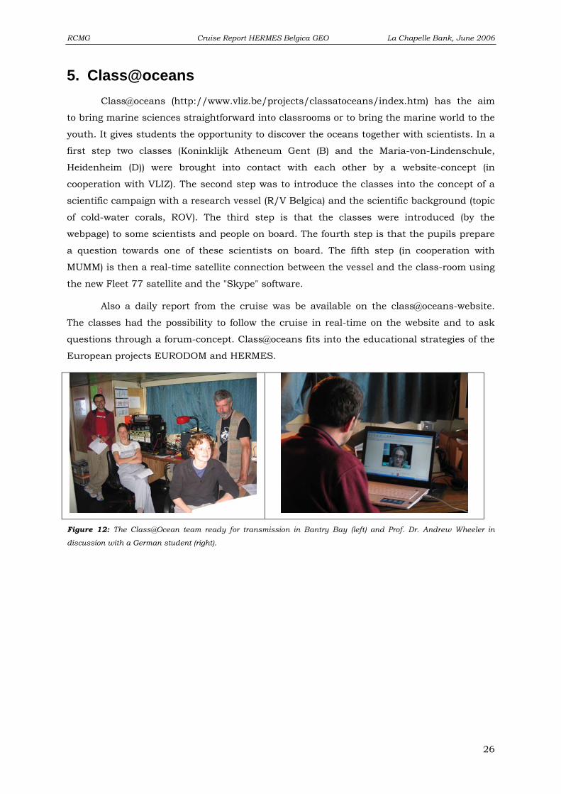
Figure 12: The Class@Ocean team ready for transmission in Bantry Bay (left) and Prof. Dr. Andrew Wheeler in
discussion with a German student (right).
26
Page 27
RCMG Cruise Report HERMES Belgica GEO La Chapelle Bank, June 2006
6. Data storage During the Belgica 06/12 campaign, 2 seismic lines were acquired over
approximately 62 km. Both lines were recorded in ELICS format and were converted in a
SegY-Motorola format with associated navigation files (these are text files containing shot
point, longitude, latitude, date and time). Multibeam data also is backed up on DVD,
including both the ‘raw’ and ‘proc’ data folders.
The ROV imagery (front and backward looking camera) was recorded on Mini-DV
tapes through hand-held cameras.
A total of 12 ROV test and scientific dives were performed. This video data is stored
on mini-DV tapes. The geophysical and CTD data are stored at the RCMG on DVD, as well
as some video extracts. For more information about the seismic, multibeam, video and
sedimentological data, please contact
Prof. Dr. Jean-Pierre Henriet ([email protected] )
or
Dr. David Van Rooij ([email protected] )
Renard Centre of Marine Geology (RCMG)
Ghent University
Krijgslaan 281 s8
9000 Gent
Belgium
Tel.: +32-9-264 4585
Fax: +32-9-264 4967
http://www.rcmg.ugent.be
27