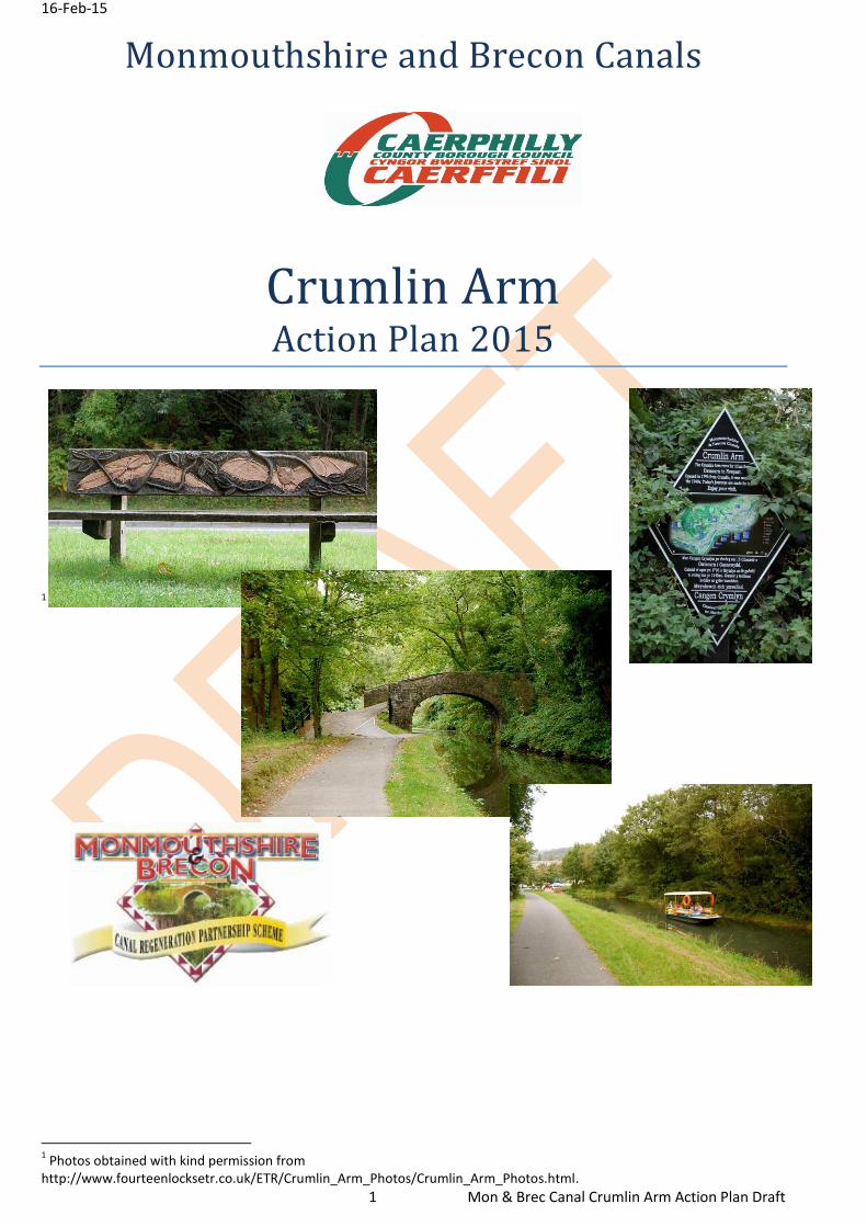
16-Feb-15 1 Mon & Brec Canal Crumlin Arm Action Plan Draft Monmouthshire and Brecon Canals Crumlin Arm Action Plan 2015 1 1 Photos obtained with kind permission from http://www.fourteenlocksetr.co.uk/ETR/Crumlin_Arm_Photos/Crumlin_Arm_Photos.html.
5. Asset Value ........................................................................................................................................................ 15
7.4. Long Term Vision ................................................................................................................................... 22
8. Implementation Plan ......................................................................................................................................... 23
Appendix- Site of proposed canoe store ........................................................................................................... 37
Appendix-Proposed site of community area, footbridge, safe walk to Ty Sign School route ........................... 38
Appendix-Turning circle and car park to link the canal to Cwmcarn Forest Drive. ........................................... 39
4 The EU’s Lisbon Strategy for Growth and Jobs, the Europe 2020 Strategy adopted in June 2010
16-Feb-15
14 Mon & Brec Canal Crumlin Arm Action Plan Draft
4.12 The Ty Sign area of Risca is a Community First area and regenerating the canal with
all its associated benefits would fit within the Welsh Government priority of Tackling
Poverty and Social Exclusion.
4.13 The development of the canal corridor should include
4.10.1. Town centre development in Risca and Crosskeys
4.10.2. Tourism attractions including the Cwmcarn Forest Drive and Visitors centre,
Adams Quarry and Navigation Colliery
4.10.3. Restoration to full navigation of the Crumlin Arm linked to restoration of the
remainder of the Mon & Brec Canal, from Cwmcarn to Brecon, via Newport.
4.11 The Crumlin Arm should be included in Caerphilly CBC’s destination management
considerations, for prioritising through Visit Wales6 and for future European funding
applications.
6 Visit Wales (welsh Government)
16-Feb-15
15 Mon & Brec Canal Crumlin Arm Action Plan Draft
5. Asset Value
5.1 The value of the Crumlin Arm is difficult to estimate because it is not just a capital
asset. It has natural beauty with protected structures and monuments, which means
that the canal has an intrinsic value over and above its monetary value.
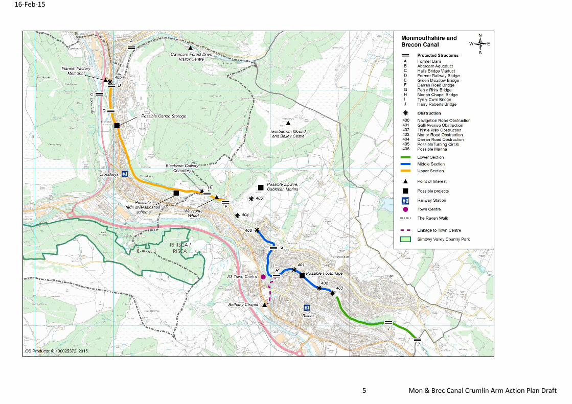
5.1.1. The Former Dam of Cwmcarn Canal Reservoir is listed as an Ancient Monument of National Importance (marked A on Map). It is an early C18th canal dam with well-preserved remains visible in section and as the site of a major engineering disaster, which informed future practice.7
5.1.2. The canal is supported by a Grade ‖ Listed structure, Abercarn Aqueduct
and Bridge, (marked B on Map). “Listed as an important early C19th canal structure with later modifications of historic interest”.8
5.1.3. Halls Bridge Railway Viaduct over the River Ebbw and Western Valleys
Railway Line is a Grade ‖ Listed structure, (marked C on Map). “Listed for its interest in the history of railway engineering in the western Valley and as an example of standard late C19th railway technology used here on a grand scale and largely unaltered since.”9
5.1.4. Former railway bridge over canal outfall. A Grade ‖ Listed structure, (marked
D on Map). “Listed as a prominent railway structure from the later C19th on a huge scale and with historical associations with the canal”10
5.1.5. Green Meadow Canal bridge, a grade ‖ listed structure (marked E on map).
“Listed as an intact bridge from late C18th”11 5.1.6. Darren Road Canal bridge, a grade ‖ listed structure (marked F on map).
“Listed as an intact bridge from late C18th”12 5.1.7. Pen Y Rhiw Canal bridge, a grade ‖ listed structure (marked G on map).
“Listed as a late C18th canal bridge retaining its character”13 5.1.8. Moriah Chapel Canal bridge, a grade ‖ listed structure (marked H on map).
“Listed as a mainly intact canal bridge from the late C18th”14 5.1.9. Tyn Y Pen Y Rhiw Canal bridge, a grade ‖ listed structure (marked I on
map). “Listed as a late C18th canal bridge retaining its character”15
5.1.10. Harry Roberts Canal Bridge, grade ‖ listed structure (marked J on map). “
Listed as a late C18th canal bridge retaining its character”16
5.2 If the canal was built in the present day, the capital cost would be in the billions.
7 CADW ancient Monument and archaeological areas act 1979 reference CAM1/1/6746, Mm259(CAE)
8 Grade ‖ Listing 21001 & 21012
9 Grade ‖ Listing 21008 & 21003
10 Grade ‖ Listing 21009
11 Grade ‖ Listing 21006 & 22509
12 Grade ‖ Listing 21007 & 22521
13 Grade ‖ Listing 22510
14 Grade ‖ Listing 22511
15 Grade ‖ Listing 22510
16 Grade ‖ Listing 22513
16-Feb-15
16 Mon & Brec Canal Crumlin Arm Action Plan Draft
6. SWOT Analysis
6.1 Strengths
Partnership approach across the Monmouthshire, Brecon and Abergavenny Canal
Region, through the Regeneration Partnership.
Proximity to existing Tourism attractions including:-
o Cwmcarn Forest Drive
o Cwmcarn Forest Visitor Centre
o Cwmcarn Forest cycle trails (which remain open during the tree
felling (see threats))
o Sirhowy Valley Country Park
o Twmbarlwm Mound and Bailey Castle
o Fourteen Locks Visitors Centre
Good public transport links, bus and rail
o Close proximity to M4 Corridor
o On National Cycle Network route
o On the Raven Walk trail, and the Cambrian Walk
Proximity to Risca (a principle town within Caerphilly County Borough)
o Purpose built event site in Risca
Rural and urban backdrops
Proximity to Navigation Colliery
The Newport arm of the canal relies on Crumlin Arm water feed.
16-Feb-15
17 Mon & Brec Canal Crumlin Arm Action Plan Draft
6.2. Weaknesses
Stretches of navigable canal are obstructed by roads.
Culverts reduce water flow with risk of blocking and causing a flood risk
Silting of canal/low water flow reduces water use
Limited existing overnight tourist accommodation
Limited signage linking the canal to Risca town centre.
Limited width for mooring points.
Some of the canal’s water feed begins on third party land
No Wi-Fi in Risca town
Conflict between towpath users
6.3. Opportunities
Regional approach to canal restoration and canal corridor development.
o To apply for relevant funding.
o To market the canal regionally
o To encourage cross-valley corporation and movement.
Replace culverts
o To increase navigable stretches
o Reduce flood risk by keeping water moving through the canal.
o Reduce maintenance cost by reducing silting of canal bed.
o Navigable tunnels increase interest to canal water users.
o At Manor Road, an aqueduct would provide a tourism focus
o Rerouting canal through Adams Quarry to restore navigation (see
risk)
Better water management
o To ensure sufficient water quantity for water travel through to
Fourteen Locks
o To improve water quality, which is currently stagnant
o To reduce flood risk on Ebbw River
o To increase development potential on Ebbw River flood plains.
Improve link with Cwmcarn Forest Drive
o Safe crossing point at terminus of canal
o Green Cycle route from Forest Drive to the canal
16-Feb-15
18 Mon & Brec Canal Crumlin Arm Action Plan Draft
o Improve and diversify the attractions at Cwmcarn Forest Drive
Improve the links with Torfaen and Cwmbran via Twmbarlwn and Mynydd Maen
o Long distance cycle routes
Improve recreation both on and off water.
o Canoes, private boats and trip boats
o Fitness walks
o Health rehabilitation groups
o Safe walking routes
Improve canal to town route
o B3 Risca Town Centre Plan.
o Movement along Moriah Hill encouraged by improving bridge with
canal imagery and links to Risca Park, town centre and Bethany
Chapel.
Potential footbridge and outdoor community/classroom area to rear of Ty-Sign School
o Safe school walking route, reducing emissions as walking
encouraged and quicker than car routes.
o Community involvement
Potential marina, or mooring points (see risk)
Potential ecological and heritage educational opportunities
Better environment
o For health
o For ecological improvements
o For business investment in tourism and canal-related services
Housing at A3 on Risca town centre plan
o Would be more attractive to investors - canal restoration can be
linked to house price increase.
Improve cycle network from town centre to canal and National Cycle Routes
Encourage annual events to raise the profile of canal and Risca.
Potential to explore green energy opportunities
o A waterwheel at Cwmcarn Feeder
o Heat retention pipes lied under the canal bed
o Energy generating outdoor gym equipment
Potential to collaborate with fibre broadband providers, since Crosskeys does not
have fibre broadband (utilising towpaths).
16-Feb-15
19 Mon & Brec Canal Crumlin Arm Action Plan Draft
6.4 Threats
Lack of funding
Weather can affect outdoor tourism /sport
Perception of Cwmcarn Forest larch tree felling due to Ramorum Virus
Invasive species impeding navigation and threatening the ecology.
Unmanaged Tree roots destroying the canal lining
Unsafe water quality due to stagnant water and rodent infestation
Conflict between cyclists, walkers, fishers, and waterway users.
Planning constraints
Flooding risks
Fourteen Locks not releasing excess of water
Sale of Adams Quarry
o This could impact on the ability to re-route the blocked section of the
canal
o This would impact on the potential marina, although a new owner
could apply for planning permission for a marina.
16-Feb-15
20 Mon & Brec Canal Crumlin Arm Action Plan Draft
7. Vision and Objectives
7.1. The Crumlin Arm of the Mon & Brec Canal is an under-utilized resource that requires
ongoing maintenance expenditure. Investment in the form of time and funding has
the potential to create a unique destination within Wales, and assist in flood
alleviation in the vicinity.
7.2. This forms part of a larger regional approach of the Mon & Brec Regeneration
Partnership to restore full navigation to the entire length of the canal and develop the
wider canal corridor.
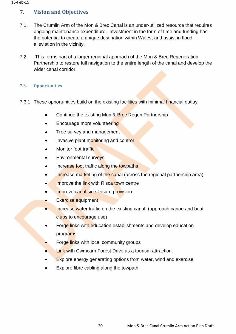
7.3. Opportunities
7.3.1 These opportunities build on the existing facilities with minimal financial outlay
Continue the existing Mon & Brec Regen Partnership
Encourage more volunteering
Tree survey and management
Invasive plant monitoring and control
Monitor foot traffic
Environmental surveys
Increase foot traffic along the towpaths
Increase marketing of the canal (across the regional partnership area)
Improve the link with Risca town centre
Improve canal side leisure provision
Exercise equipment
Increase water traffic on the existing canal (approach canoe and boat
clubs to encourage use)
Forge links with education establishments and develop education
programs
Forge links with local community groups
Link with Cwmcarn Forest Drive as a tourism attraction.
Explore energy generating options from water, wind and exercise.
Explore fibre cabling along the towpath.
16-Feb-15
21 Mon & Brec Canal Crumlin Arm Action Plan Draft
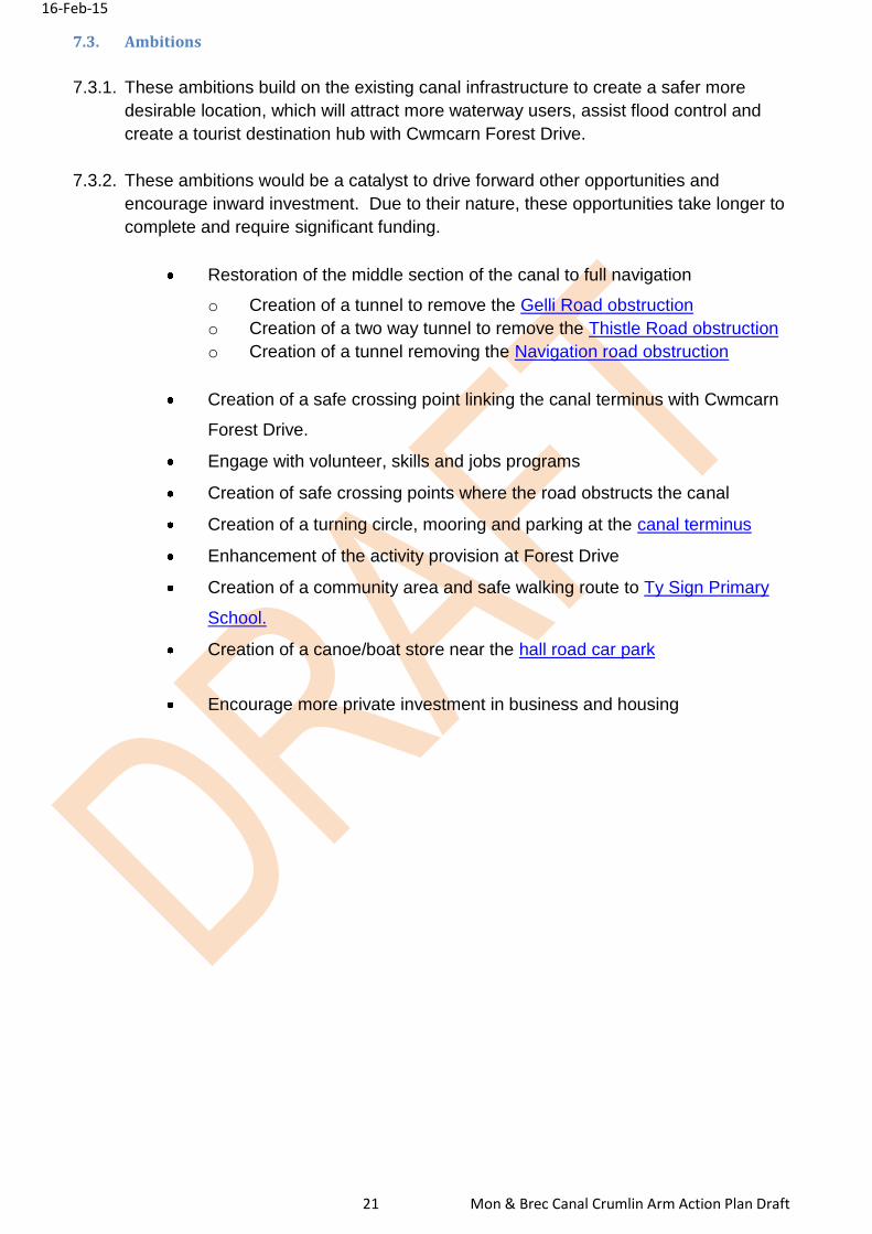
7.3. Ambitions
7.3.1. These ambitions build on the existing canal infrastructure to create a safer more
desirable location, which will attract more waterway users, assist flood control and
create a tourist destination hub with Cwmcarn Forest Drive.
7.3.2. These ambitions would be a catalyst to drive forward other opportunities and
encourage inward investment. Due to their nature, these opportunities take longer to
complete and require significant funding.
Restoration of the middle section of the canal to full navigation
o Creation of a tunnel to remove the Gelli Road obstruction
o Creation of a two way tunnel to remove the Thistle Road obstruction
o Creation of a tunnel removing the Navigation road obstruction
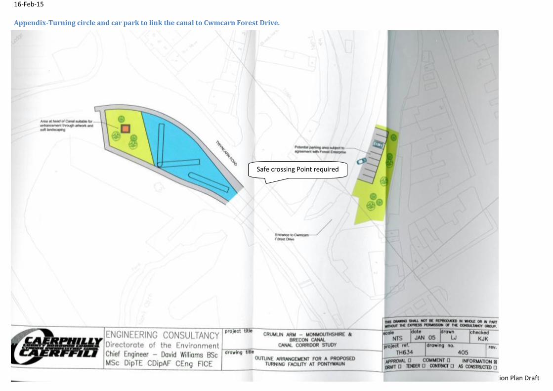
Creation of a safe crossing point linking the canal terminus with Cwmcarn
Forest Drive.
Engage with volunteer, skills and jobs programs
Creation of safe crossing points where the road obstructs the canal
Creation of a turning circle, mooring and parking at the canal terminus
Enhancement of the activity provision at Forest Drive
Creation of a community area and safe walking route to Ty Sign Primary
School.
Creation of a canoe/boat store near the hall road car park
Encourage more private investment in business and housing
16-Feb-15
22 Mon & Brec Canal Crumlin Arm Action Plan Draft
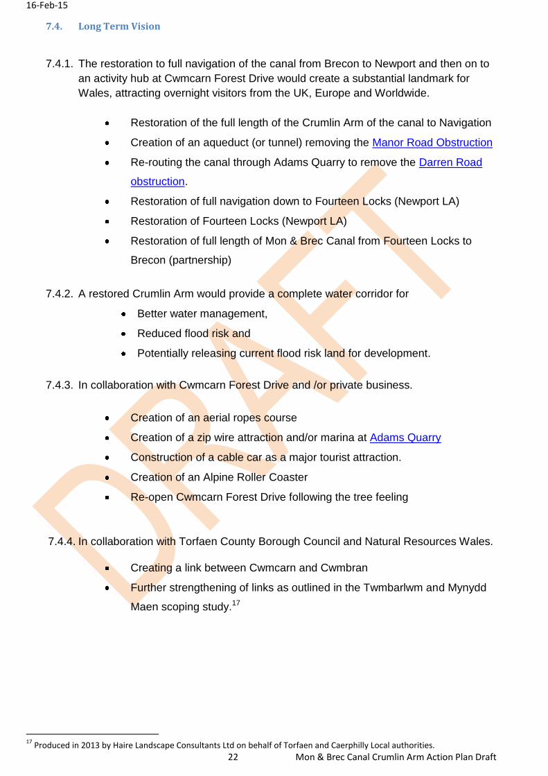
7.4. Long Term Vision
7.4.1. The restoration to full navigation of the canal from Brecon to Newport and then on to
an activity hub at Cwmcarn Forest Drive would create a substantial landmark for
Wales, attracting overnight visitors from the UK, Europe and Worldwide.
Restoration of the full length of the Crumlin Arm of the canal to Navigation
Creation of an aqueduct (or tunnel) removing the Manor Road Obstruction
Re-routing the canal through Adams Quarry to remove the Darren Road
obstruction.
Restoration of full navigation down to Fourteen Locks (Newport LA)
Restoration of Fourteen Locks (Newport LA)
Restoration of full length of Mon & Brec Canal from Fourteen Locks to
Brecon (partnership)
7.4.2. A restored Crumlin Arm would provide a complete water corridor for
Better water management,
Reduced flood risk and
Potentially releasing current flood risk land for development.
7.4.3. In collaboration with Cwmcarn Forest Drive and /or private business.
Creation of an aerial ropes course
Creation of a zip wire attraction and/or marina at Adams Quarry
Construction of a cable car as a major tourist attraction.
Creation of an Alpine Roller Coaster
Re-open Cwmcarn Forest Drive following the tree feeling
7.4.4. In collaboration with Torfaen County Borough Council and Natural Resources Wales.
Creating a link between Cwmcarn and Cwmbran
Further strengthening of links as outlined in the Twmbarlwm and Mynydd
Maen scoping study.17
17
Produced in 2013 by Haire Landscape Consultants Ltd on behalf of Torfaen and Caerphilly Local authorities.
16-Feb-15
23 Mon & Brec Canal Crumlin Arm Action Plan Draft
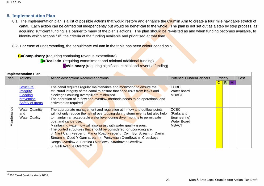
8. Implementation Plan 8.1. The Implementation plan is a list of possible actions that would restore and enhance the Crumlin Arm to create a four mile navigable stretch of
canal. Each action can be carried out independently but would be beneficial to the whole. The plan is not set out as a step by step process, as
acquiring sufficient funding is a barrier to many of the plan’s actions. The plan should be re-visited as and when funding becomes available, to
identify which actions fulfil the criteria of the funding available and prioritised at that time.
8.2. For ease of understanding, the penultimate column in the table has been colour coded as :-
R=Realistic (requiring commitment and minimal additional funding)
V=Visionary (requiring significant capital and revenue funding)
18
P56 Canal Corridor study 2005
Implementation Plan
Plan Actions Action description/ Recommendations Potential Funder/Partners Priority Cost
C R V
Ma
inte
na
nce
Structural Integrity Flooding prevention Safety of areas
The canal requires regular maintenance and monitoring to ensure the structural integrity of the canal to ensure that flood risks from leaks and blockages causing overspill are minimised. The operation of in-flow and overflow methods needs to be operational and activated as required.
CCBC Water board MBACT
Water Quantity and Water Quality
The appropriate management and regulation at in-flow and outflow points will not only reduce the risk of overtopping during storm events but also help to maintain an acceptable water level during dryer months to permit safe boat and canoe use. Maintaining water flow will also assist with water quality issues. The control structures that should be considered for upgrading are:
o Nant Carn Feeder o Manor Road Feeder o Cwm Byr Stream o Darran
Stream o Coed Y Garn stream o Pontywaun Overflows o Crosskeys
Deeps Overflow o Fernlea Overflowo Strathaven Overflow
o Gelli Avenue Overflow.18
CCBC (Parks and Engineering) Water Board MBACT
16-Feb-15
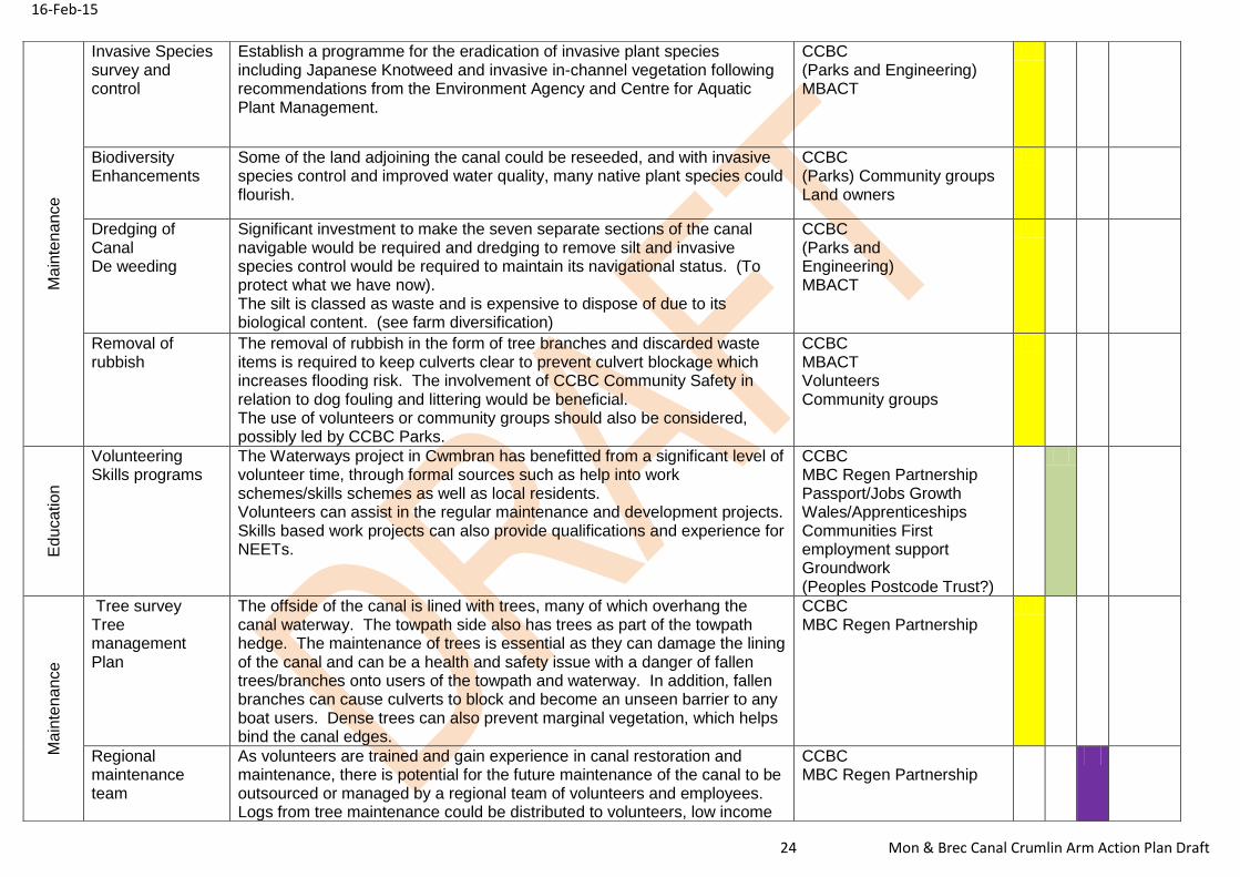
24 Mon & Brec Canal Crumlin Arm Action Plan Draft
Ma
inte
na
nce
Invasive Species survey and control
Establish a programme for the eradication of invasive plant species including Japanese Knotweed and invasive in-channel vegetation following recommendations from the Environment Agency and Centre for Aquatic Plant Management.
CCBC (Parks and Engineering) MBACT
Biodiversity Enhancements
Some of the land adjoining the canal could be reseeded, and with invasive species control and improved water quality, many native plant species could flourish.
CCBC (Parks) Community groups Land owners
Dredging of Canal De weeding
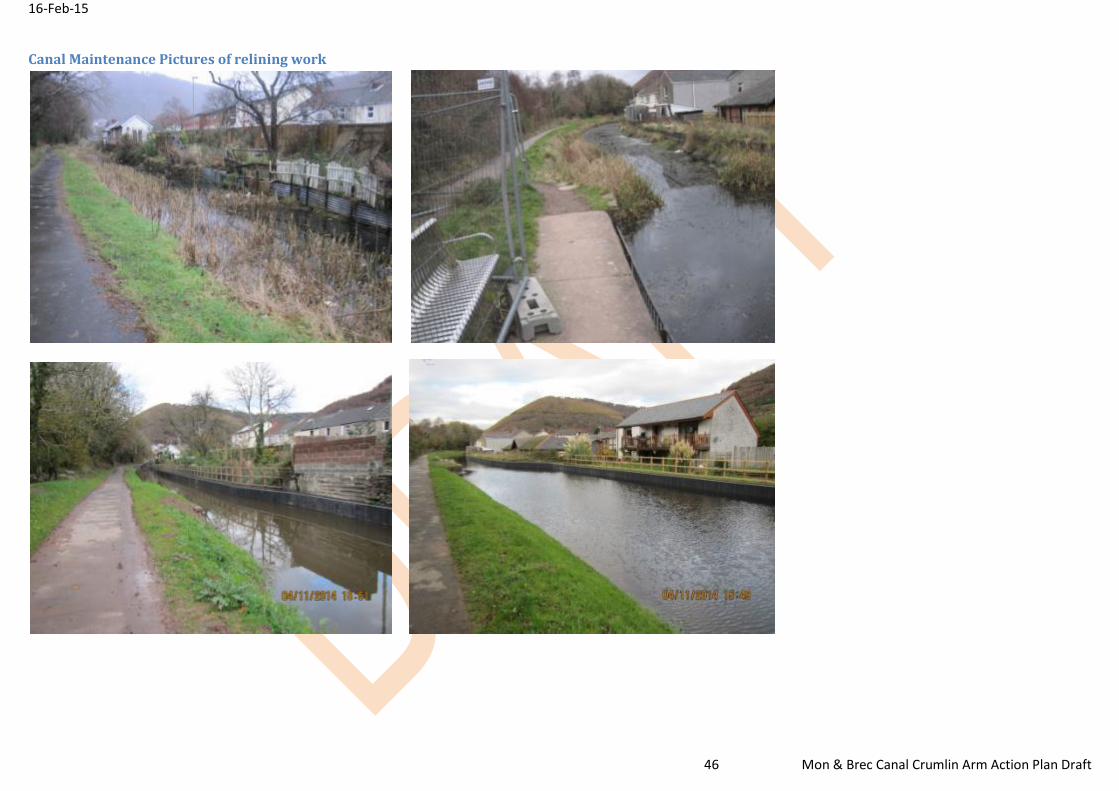
Significant investment to make the seven separate sections of the canal navigable would be required and dredging to remove silt and invasive species control would be required to maintain its navigational status. (To protect what we have now). The silt is classed as waste and is expensive to dispose of due to its biological content. (see farm diversification)
CCBC (Parks and Engineering) MBACT
Removal of rubbish
The removal of rubbish in the form of tree branches and discarded waste items is required to keep culverts clear to prevent culvert blockage which increases flooding risk. The involvement of CCBC Community Safety in relation to dog fouling and littering would be beneficial. The use of volunteers or community groups should also be considered, possibly led by CCBC Parks.
CCBC MBACT Volunteers Community groups
Ed
uca
tion
Volunteering Skills programs
The Waterways project in Cwmbran has benefitted from a significant level of volunteer time, through formal sources such as help into work schemes/skills schemes as well as local residents. Volunteers can assist in the regular maintenance and development projects. Skills based work projects can also provide qualifications and experience for NEETs.
CCBC MBC Regen Partnership Passport/Jobs Growth Wales/Apprenticeships Communities First employment support Groundwork (Peoples Postcode Trust?)
Ma
inte
na
nce
Tree survey Tree management Plan
The offside of the canal is lined with trees, many of which overhang the canal waterway. The towpath side also has trees as part of the towpath hedge. The maintenance of trees is essential as they can damage the lining of the canal and can be a health and safety issue with a danger of fallen trees/branches onto users of the towpath and waterway. In addition, fallen branches can cause culverts to block and become an unseen barrier to any boat users. Dense trees can also prevent marginal vegetation, which helps bind the canal edges.
CCBC MBC Regen Partnership
Regional maintenance team
As volunteers are trained and gain experience in canal restoration and maintenance, there is potential for the future maintenance of the canal to be outsourced or managed by a regional team of volunteers and employees. Logs from tree maintenance could be distributed to volunteers, low income
CCBC MBC Regen Partnership
16-Feb-15
25 Mon & Brec Canal Crumlin Arm Action Plan Draft
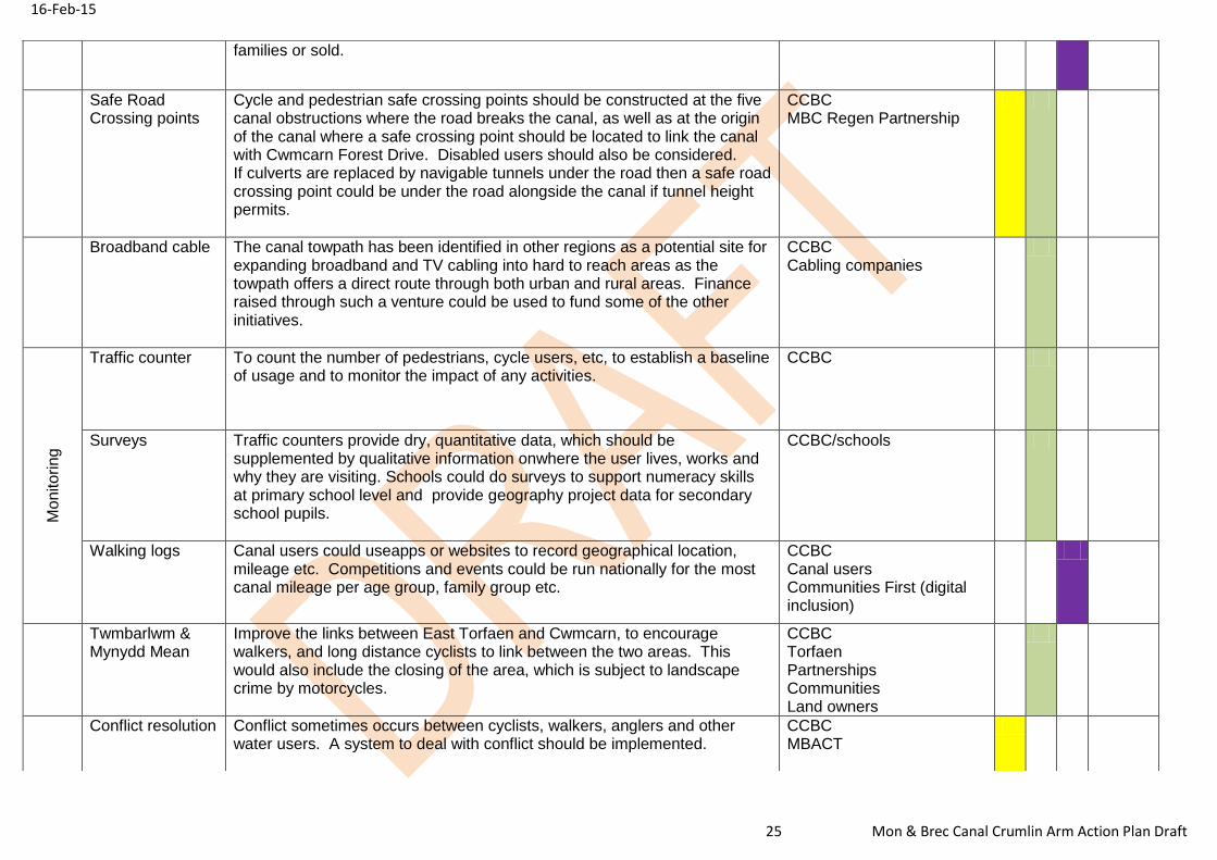
families or sold.
Safe Road Crossing points
Cycle and pedestrian safe crossing points should be constructed at the five canal obstructions where the road breaks the canal, as well as at the origin of the canal where a safe crossing point should be located to link the canal with Cwmcarn Forest Drive. Disabled users should also be considered. If culverts are replaced by navigable tunnels under the road then a safe road crossing point could be under the road alongside the canal if tunnel height permits.
CCBC MBC Regen Partnership
Broadband cable The canal towpath has been identified in other regions as a potential site for expanding broadband and TV cabling into hard to reach areas as the towpath offers a direct route through both urban and rural areas. Finance raised through such a venture could be used to fund some of the other initiatives.
CCBC Cabling companies
Mo
nito
ring
Traffic counter To count the number of pedestrians, cycle users, etc, to establish a baseline of usage and to monitor the impact of any activities.
CCBC
Surveys Traffic counters provide dry, quantitative data, which should be supplemented by qualitative information onwhere the user lives, works and why they are visiting. Schools could do surveys to support numeracy skills at primary school level and provide geography project data for secondary school pupils.
CCBC/schools
Walking logs
Canal users could useapps or websites to record geographical location, mileage etc. Competitions and events could be run nationally for the most canal mileage per age group, family group etc.
CCBC Canal users Communities First (digital inclusion)
Twmbarlwm & Mynydd Mean
Improve the links between East Torfaen and Cwmcarn, to encourage walkers, and long distance cyclists to link between the two areas. This would also include the closing of the area, which is subject to landscape crime by motorcycles.
CCBC Torfaen Partnerships Communities Land owners
Conflict resolution Conflict sometimes occurs between cyclists, walkers, anglers and other water users. A system to deal with conflict should be implemented.
CCBC MBACT
16-Feb-15
26 Mon & Brec Canal Crumlin Arm Action Plan Draft
Plan Actions Action description/ Recommendations Potential Funder/Partners Priority Cost
C R V E
duca
tion
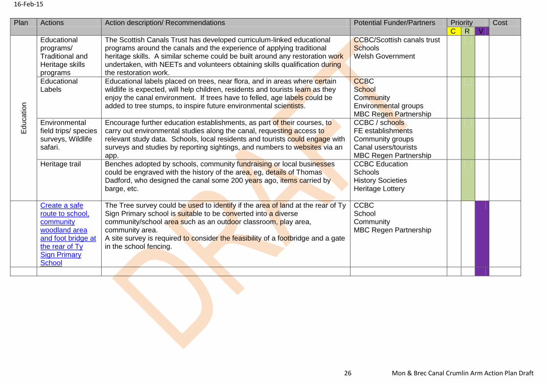
Educational programs/ Traditional and Heritage skills programs
The Scottish Canals Trust has developed curriculum-linked educational programs around the canals and the experience of applying traditional heritage skills. A similar scheme could be built around any restoration work undertaken, with NEETs and volunteers obtaining skills qualification during the restoration work.
CCBC/Scottish canals trust Schools Welsh Government
Educational Labels
Educational labels placed on trees, near flora, and in areas where certain wildlife is expected, will help children, residents and tourists learn as they enjoy the canal environment. If trees have to felled, age labels could be added to tree stumps, to inspire future environmental scientists.
CCBC School Community Environmental groups MBC Regen Partnership
Environmental field trips/ species surveys, Wildlife safari.
Encourage further education establishments, as part of their courses, to carry out environmental studies along the canal, requesting access to relevant study data. Schools, local residents and tourists could engage with surveys and studies by reporting sightings, and numbers to websites via an app.
CCBC / schools FE establishments Community groups Canal users/tourists MBC Regen Partnership
Heritage trail Benches adopted by schools, community fundraising or local businesses could be engraved with the history of the area, eg, details of Thomas Dadford, who designed the canal some 200 years ago, items carried by barge, etc.
CCBC Education Schools History Societies Heritage Lottery
Create a safe route to school, community woodland area and foot bridge at the rear of Ty Sign Primary School
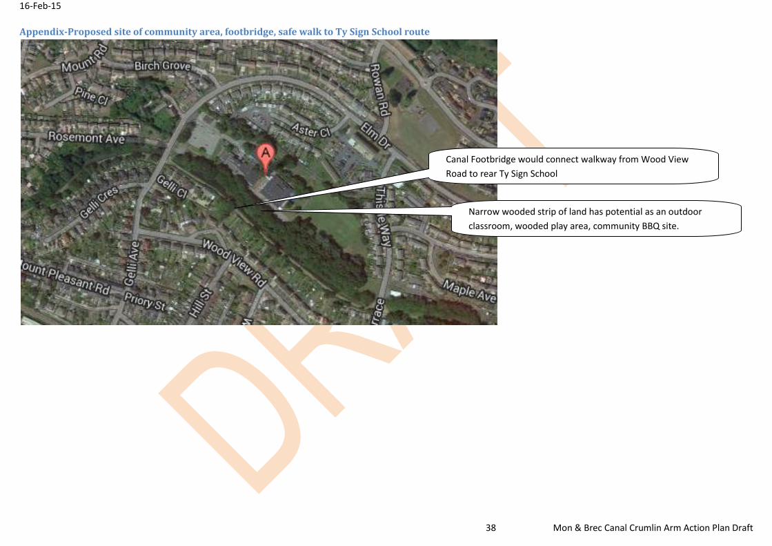
The Tree survey could be used to identify if the area of land at the rear of Ty Sign Primary school is suitable to be converted into a diverse community/school area such as an outdoor classroom, play area, community area. A site survey is required to consider the feasibility of a footbridge and a gate in the school fencing.
CCBC School Community MBC Regen Partnership
16-Feb-15
27 Mon & Brec Canal Crumlin Arm Action Plan Draft
Plan Actions Action description/ Recommendations Partners/Funding Priority Cost
C R V
Tow
n C
en
tre L
inks
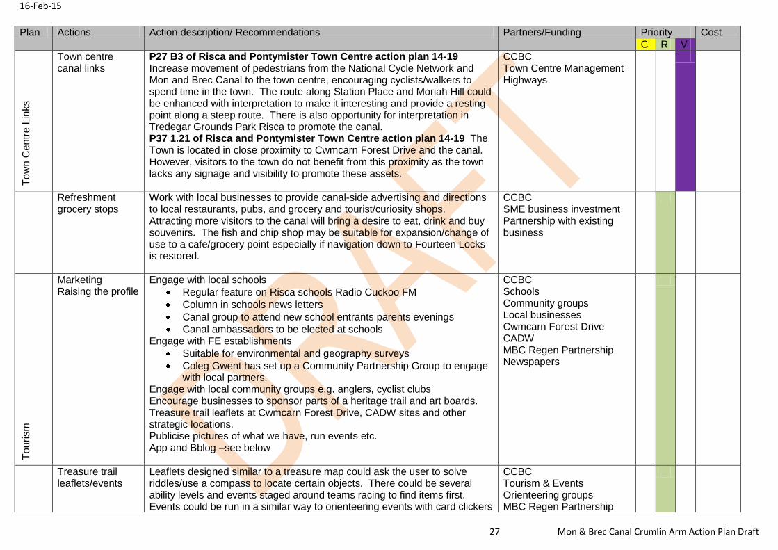
Town centre canal links
P27 B3 of Risca and Pontymister Town Centre action plan 14-19 Increase movement of pedestrians from the National Cycle Network and Mon and Brec Canal to the town centre, encouraging cyclists/walkers to spend time in the town. The route along Station Place and Moriah Hill could be enhanced with interpretation to make it interesting and provide a resting point along a steep route. There is also opportunity for interpretation in Tredegar Grounds Park Risca to promote the canal. P37 1.21 of Risca and Pontymister Town Centre action plan 14-19 The Town is located in close proximity to Cwmcarn Forest Drive and the canal. However, visitors to the town do not benefit from this proximity as the town lacks any signage and visibility to promote these assets.
CCBC Town Centre Management Highways
Refreshment grocery stops
Work with local businesses to provide canal-side advertising and directions to local restaurants, pubs, and grocery and tourist/curiosity shops. Attracting more visitors to the canal will bring a desire to eat, drink and buy souvenirs. The fish and chip shop may be suitable for expansion/change of use to a cafe/grocery point especially if navigation down to Fourteen Locks is restored.
CCBC SME business investment Partnership with existing business
Tou
rism
Marketing Raising the profile
Engage with local schools
Regular feature on Risca schools Radio Cuckoo FM
Column in schools news letters
Canal group to attend new school entrants parents evenings
Canal ambassadors to be elected at schools Engage with FE establishments
Suitable for environmental and geography surveys
Coleg Gwent has set up a Community Partnership Group to engage with local partners.
Engage with local community groups e.g. anglers, cyclist clubs Encourage businesses to sponsor parts of a heritage trail and art boards. Treasure trail leaflets at Cwmcarn Forest Drive, CADW sites and other strategic locations. Publicise pictures of what we have, run events etc. App and Bblog –see below
CCBC Schools Community groups Local businesses Cwmcarn Forest Drive CADW MBC Regen Partnership Newspapers
Treasure trail leaflets/events
Leaflets designed similar to a treasure map could ask the user to solve riddles/use a compass to locate certain objects. There could be several ability levels and events staged around teams racing to find items first. Events could be run in a similar way to orienteering events with card clickers
CCBC Tourism & Events Orienteering groups MBC Regen Partnership
16-Feb-15
28 Mon & Brec Canal Crumlin Arm Action Plan Draft
to punch cards required or numbers similar to bar codes to be engraved into static objects which participants would need to record in correct spaces on the treasure leaflet.
Cwmcarn Forest Drive
Crumlin Arm APP Blog.
Develop an app and blog where treasure trails, heritage trail, events, walking logs, volunteer opportunities, photos, etc can be found. This could be linked to a wider tourism initiative for all major tourism destinations.
CCBC MBC Regen Partnership General public
Art exhibitions Art boards
Walkers and waterway users pass slowly through the area. Therefore, an outdoor exhibition which could be static or rotated would provide focal points throughout the stretch of the canal. Static art could take the form of sculptures and/or mosaics permanently fixed while display board could provide points for rotated art and business advertising points. Local schools and community groups and/or national competitions could provide the material for these exhibitions
CCBC School Community Gallery in Caerphilly Existing online competitions
Mile markers/Art boards
Mile markers used to exist along canal stretches. Canal River Trust is considering erecting new markers along the canal from Crumlin to Brecon. Art boards could be attached to these markers, some for permanent displays and some for rotating displays. The rotating displays would allow the canal to change displays in line with community themes to create ongoing and cross valley interest
CCBC MBC Regen Partnership Community
Restaurant boats Static
There is a possible mooring site in the middle section where it may be possible to moor a narrowboat that could be converted to a restaurant boat. This could be as a new business investment, a partnership with a nearby fish and chip shop, or as a community group purchase scheme, (using local labour teaching catering skills)
CCBC SME business investment Partnership with existing business Community group Skills for employment
Mobile Restaurant Dinner cruises
If the canal channel in this middle section was extended by removing the road obstructions this boat could offer dinner cruises.
CCBC SME business investment Partnership with existing business Community group Skills for employment
16-Feb-15
29 Mon & Brec Canal Crumlin Arm Action Plan Draft
Events The Mon & Brec Regen Partnership arranges an annual Canalathon
involving cycling, canoeing and walking over a 35mile route. The Crumlin arm could arrange a similar event, with cycling starting in the Forest Drive and down to the canal, where canoes can be used and carried over the roadway obstructions to the boundary with Newport. It could be extended to Fourteen Locks where walking could commence on toward a further location. Other events such as a duck race could be arranged on a smaller scale depending on community engagement.
CCBC MBC Regen Partnership Cwmcarn Forest Drive
L
eis
ure
Cycle hire Stations
Cycle hire stations similar to those in major cities to encourage visitors to hire cycles and visit Cwmcarn forest drive, the six listed canal bridges and Fourteen Locks in Newport area. Cycle stations at Manor Road, Hall Road car park and in partner LA areas such as at Fourteen Locks Newport, Five Locks Cwmbran and at other strategic points en-route to Brecon. This could be part of a wider network of hire and return stations, meaning that returning to the point of origin is not required.
CCBC MBC Regen Partnership Cycle hire businesses SME investment. British Waterways Cwmcarn Forest Drive
Canoeing Rowing
Encouraging the use of the canal waterway itself through use of canoe and rowboats should be encouraged as regular movement through the water helps with reducing the silt build-up. Engage with local clubs and SMEs to set up canoe and hire stations, linking with the Forest Drive to make it an activity hub. Facilities for disabled canoeists should be made available. Canoe trips with overnight camping could be possible at Cwmcarn and if full navigation was restored canoes travelling 6-8miles per day could leave Brecon and travel to Cwmcarn, which would benefit local campgrounds and businesses (pubs and shops).
CCBC Cwmcarn Forest Drive Caerphilly Adventure Group Local boat clubs SME/ business investment MBC Regen Partnership
Waterway regulation/advice boards
There are health and safety regulations applicable to waterway users, e.g. no movement of boats after dusk. Information boards advising canoeists, motorised boats, etc should be erected. Directions to showers, restrooms and other facilities should be included where applicable.
CCBC Local boat clubs
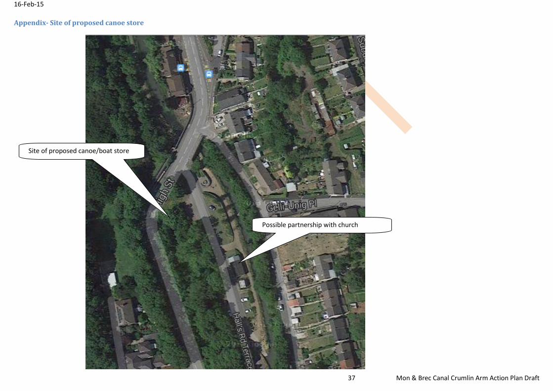
Canoe/boat Store The Hall Road car park has been identified as a possible development site with a strip of land that could house a small canoe or boat store. This is near a boat slip way for ease of canal access. There is a metal church adjacent to this part of the canal which could offer a partnership opportunity between SME boat owner investment and the church where restroom and dry tuition could be delivered. A similar hire point could possibly be sited at Manor Road if full navigation to the upper and middle sections is achieved.
CCBC Metal Church SME/ business investment Local canoe/boat clubs
Angling clubs There are existing angling clubs using various sections of the canal. CCBC CCBC
16-Feb-15
30 Mon & Brec Canal Crumlin Arm Action Plan Draft
should encourage closer links with the clubs, and regular cyclists and residents. Consideration should be given to engaging with National Fishery in relation to the fish stock in the canal
Angling clubs Residents National Fishery
Segway Tours The canal towpath would lend itself to novice “segway” users. Tours could be run by SME businesses to link up with heritage, educational, Art exhibitions as well as linking with an off road segway track that could be developed at the Forest Drive
CCBC SME/ business investment Cwmcarn Forest Drive
Motorised boats Privately owned and business boats should be encouraged to the area as their waterways licence brings in revenue. The more attractive and longer the navigable sections the more boats that will be attracted to the area. At present, a trip boat may be viable on the lower (southern section) from Manor Road to Harry Roberts Bridge. Motorised boats on the canal should attract micro-business investment in the form of boat repairer/mechanic workshops. Trip boats, day hire, overnight timeshares, boat hotels, and sea going craft will all be attracted to the area if full navigation could be restored.
CCBC business investment Local canoe/boat clubs
Horse drawn trip boats
In addition to motorised trip boats. Horse-drawn trip boats would provide an added attraction.
CCBC Business investment Local canoe/boat clubs
Exercise trail Exercise equipment at suitable points alongside the towpath, such as pull-up bars, hand bikes and cross trainers. Siting individual pieces throughout the stretch of canal would encourage movement throughout the canal and not just at one location. Equipment can be family and disabled friendly as well as pieces for the serious athlete.
CCBC Community groups Business investment
Green Energy Exercise equipment
Exercise equipment such as the cross trainer, rowing machines and hand bikes, amongst others can generate 50-100watts of energy depending on the fitness of the user. This equipment can be used to charge mobile phone and power canal side lights, and possibly, depending on location, send power into the local grid.
CCBC Community groups Business investment Green energy grants.
Walking tours Health tours
In partnership with local GPs and Aneurin Bevan Health Board, walks and exercise programs can be developed to offer patients, such as cardiac recovery and other physiotherapy patients, the opportunity to recover in the outdoors.
CCBC ABHB Local GPs
Boat Taxi Encourage a boat taxi from Whysom’s Wharf to the Forest Drive. As the canal is lengthened, boat taxis could operate along the full stretch of CCBC’s canal and also from Fourteen Locks in Newport, stopping at strategic points for tourism and business links.
CCBC Local SMEs MBC Regen Partnership.
16-Feb-15
31 Mon & Brec Canal Crumlin Arm Action Plan Draft
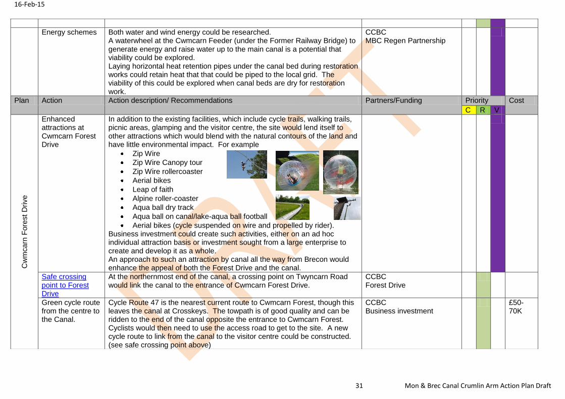
Energy schemes Both water and wind energy could be researched. A waterwheel at the Cwmcarn Feeder (under the Former Railway Bridge) to generate energy and raise water up to the main canal is a potential that viability could be explored. Laying horizontal heat retention pipes under the canal bed during restoration works could retain heat that that could be piped to the local grid. The viability of this could be explored when canal beds are dry for restoration work.
CCBC MBC Regen Partnership
Plan Action Action description/ Recommendations Partners/Funding Priority Cost
C R V
Cw
mca
rn F
ore
st
Drive
Enhanced attractions at Cwmcarn Forest Drive
In addition to the existing facilities, which include cycle trails, walking trails, picnic areas, glamping and the visitor centre, the site would lend itself to other attractions which would blend with the natural contours of the land and have little environmental impact. For example
Zip Wire
Zip Wire Canopy tour
Zip Wire rollercoaster
Aerial bikes
Leap of faith
Alpine roller-coaster
Aqua ball dry track
Aqua ball on canal/lake-aqua ball football
Aerial bikes (cycle suspended on wire and propelled by rider). Business investment could create such activities, either on an ad hoc individual attraction basis or investment sought from a large enterprise to create and develop it as a whole. An approach to such an attraction by canal all the way from Brecon would enhance the appeal of both the Forest Drive and the canal.
Safe crossing point to Forest Drive
At the northernmost end of the canal, a crossing point on Twyncarn Road would link the canal to the entrance of Cwmcarn Forest Drive.
CCBC Forest Drive
Green cycle route from the centre to the Canal.
Cycle Route 47 is the nearest current route to Cwmcarn Forest, though this leaves the canal at Crosskeys. The towpath is of good quality and can be ridden to the end of the canal opposite the entrance to Cwmcarn Forest. Cyclists would then need to use the access road to get to the site. A new cycle route to link from the canal to the visitor centre could be constructed. (see safe crossing point above)
CCBC Business investment
£50-70K
16-Feb-15
32 Mon & Brec Canal Crumlin Arm Action Plan Draft
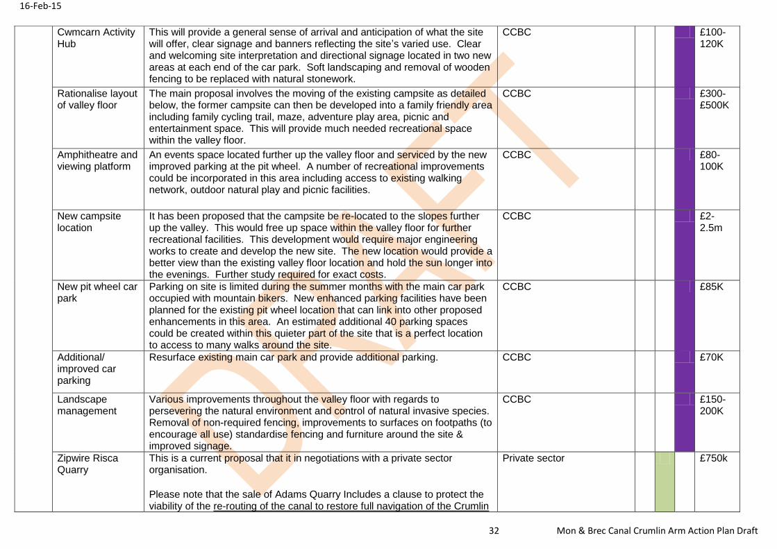
Cwmcarn Activity Hub
This will provide a general sense of arrival and anticipation of what the site will offer, clear signage and banners reflecting the site’s varied use. Clear and welcoming site interpretation and directional signage located in two new areas at each end of the car park. Soft landscaping and removal of wooden fencing to be replaced with natural stonework.
CCBC £100-120K
Rationalise layout of valley floor
The main proposal involves the moving of the existing campsite as detailed below, the former campsite can then be developed into a family friendly area including family cycling trail, maze, adventure play area, picnic and entertainment space. This will provide much needed recreational space within the valley floor.
CCBC £300-£500K
Amphitheatre and viewing platform
An events space located further up the valley floor and serviced by the new improved parking at the pit wheel. A number of recreational improvements could be incorporated in this area including access to existing walking network, outdoor natural play and picnic facilities.
CCBC £80-100K
New campsite location
It has been proposed that the campsite be re-located to the slopes further up the valley. This would free up space within the valley floor for further recreational facilities. This development would require major engineering works to create and develop the new site. The new location would provide a better view than the existing valley floor location and hold the sun longer into the evenings. Further study required for exact costs.
CCBC £2-2.5m
New pit wheel car park
Parking on site is limited during the summer months with the main car park occupied with mountain bikers. New enhanced parking facilities have been planned for the existing pit wheel location that can link into other proposed enhancements in this area. An estimated additional 40 parking spaces could be created within this quieter part of the site that is a perfect location to access to many walks around the site.
CCBC £85K
Additional/ improved car parking
Resurface existing main car park and provide additional parking. CCBC £70K
Landscape management
Various improvements throughout the valley floor with regards to persevering the natural environment and control of natural invasive species. Removal of non-required fencing, improvements to surfaces on footpaths (to encourage all use) standardise fencing and furniture around the site & improved signage.
CCBC £150-200K
Zipwire Risca Quarry
This is a current proposal that it in negotiations with a private sector organisation.
Please note that the sale of Adams Quarry Includes a clause to protect the viability of the re-routing of the canal to restore full navigation of the Crumlin
Private sector £750k
16-Feb-15
33 Mon & Brec Canal Crumlin Arm Action Plan Draft
Arm
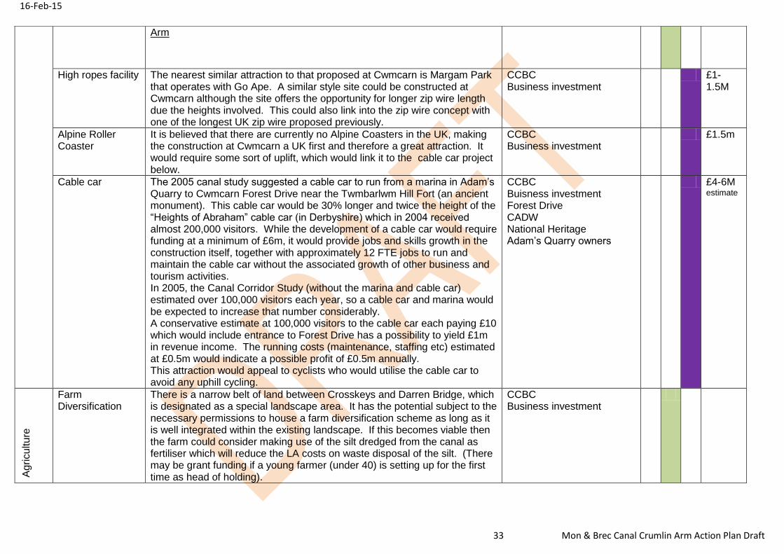
High ropes facility
The nearest similar attraction to that proposed at Cwmcarn is Margam Park that operates with Go Ape. A similar style site could be constructed at Cwmcarn although the site offers the opportunity for longer zip wire length due the heights involved. This could also link into the zip wire concept with one of the longest UK zip wire proposed previously.
CCBC Business investment
£1-1.5M
Alpine Roller Coaster
It is believed that there are currently no Alpine Coasters in the UK, making the construction at Cwmcarn a UK first and therefore a great attraction. It would require some sort of uplift, which would link it to the cable car project below.
CCBC Business investment
£1.5m
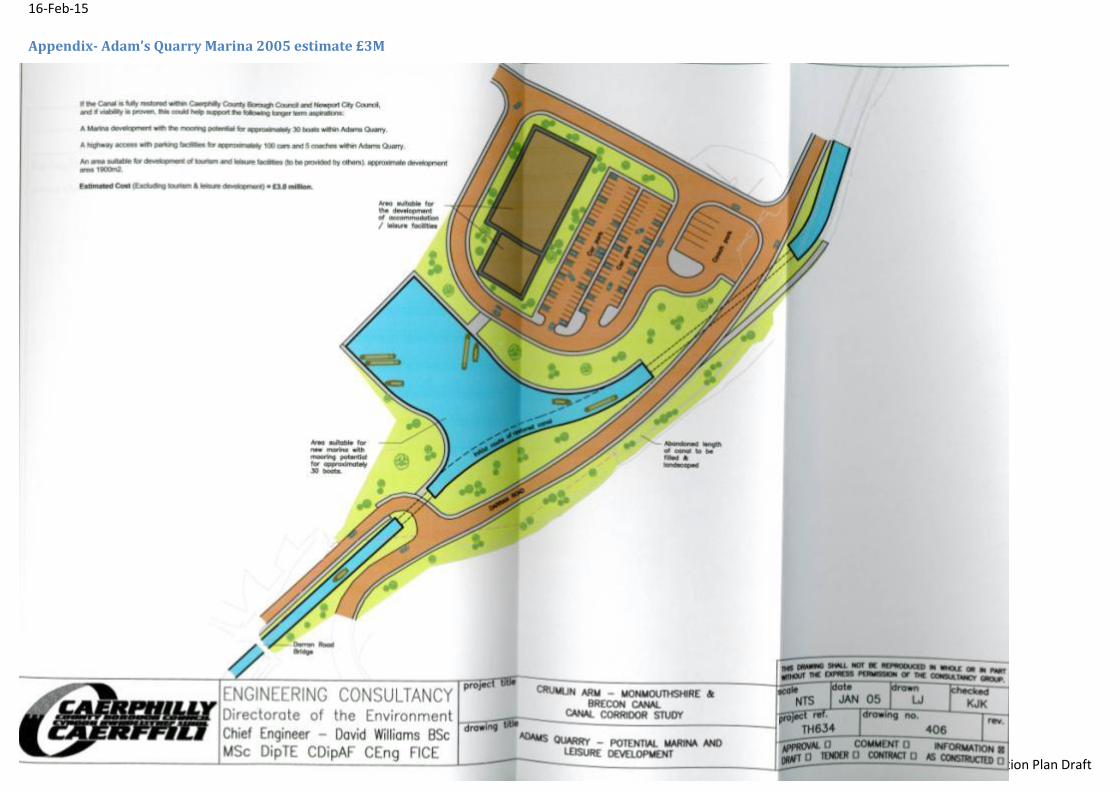
Cable car The 2005 canal study suggested a cable car to run from a marina in Adam’s Quarry to Cwmcarn Forest Drive near the Twmbarlwm Hill Fort (an ancient monument). This cable car would be 30% longer and twice the height of the “Heights of Abraham” cable car (in Derbyshire) which in 2004 received almost 200,000 visitors. While the development of a cable car would require funding at a minimum of £6m, it would provide jobs and skills growth in the construction itself, together with approximately 12 FTE jobs to run and maintain the cable car without the associated growth of other business and tourism activities. In 2005, the Canal Corridor Study (without the marina and cable car) estimated over 100,000 visitors each year, so a cable car and marina would be expected to increase that number considerably. A conservative estimate at 100,000 visitors to the cable car each paying £10 which would include entrance to Forest Drive has a possibility to yield £1m in revenue income. The running costs (maintenance, staffing etc) estimated at £0.5m would indicate a possible profit of £0.5m annually. This attraction would appeal to cyclists who would utilise the cable car to avoid any uphill cycling.
There is a narrow belt of land between Crosskeys and Darren Bridge, which is designated as a special landscape area. It has the potential subject to the necessary permissions to house a farm diversification scheme as long as it is well integrated within the existing landscape. If this becomes viable then the farm could consider making use of the silt dredged from the canal as fertiliser which will reduce the LA costs on waste disposal of the silt. (There may be grant funding if a young farmer (under 40) is setting up for the first time as head of holding).
CCBC Business investment
16-Feb-15
34 Mon & Brec Canal Crumlin Arm Action Plan Draft
Plan Action Action/Descriptions Partner/Funding Priority Cost
C R V
Ca
na
l R
esto
ratio
n
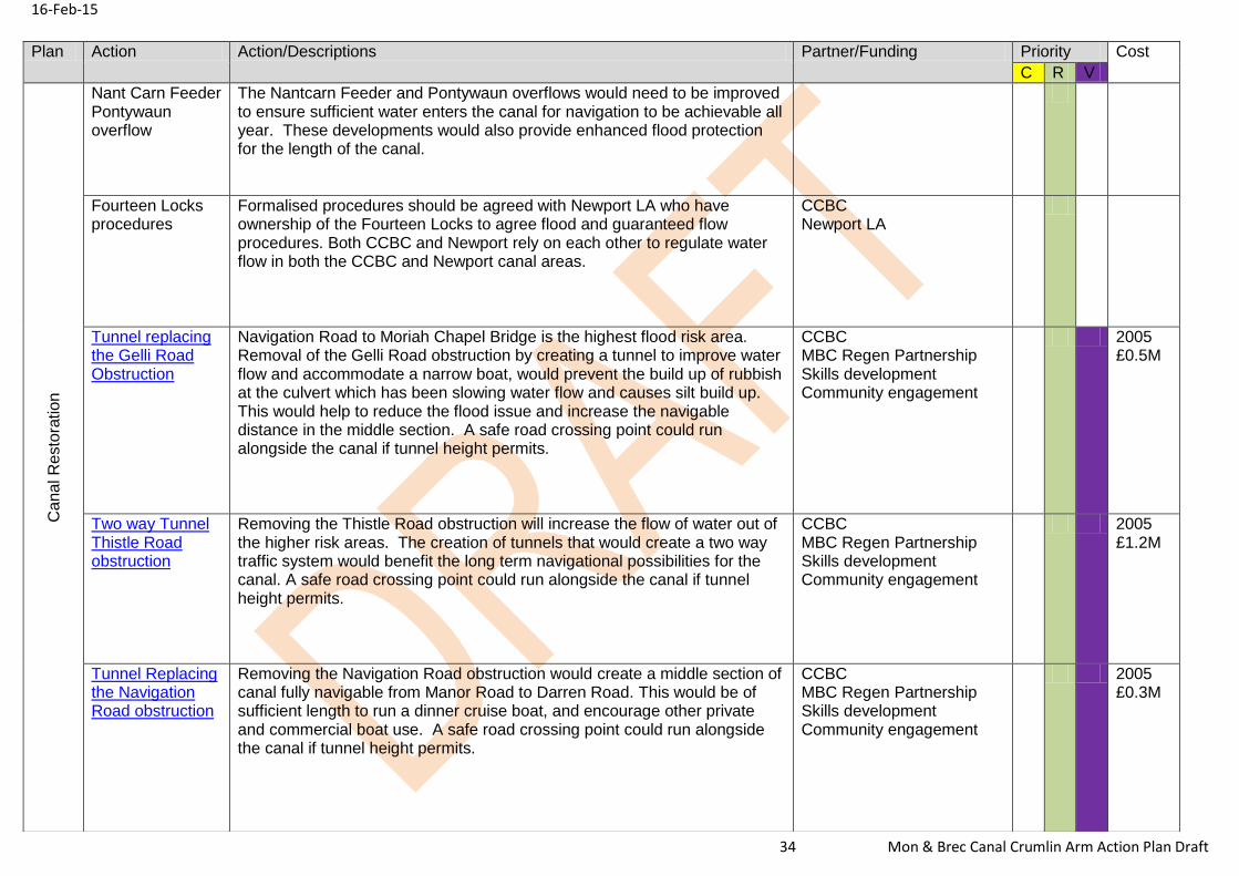
Nant Carn Feeder Pontywaun overflow
The Nantcarn Feeder and Pontywaun overflows would need to be improved to ensure sufficient water enters the canal for navigation to be achievable all year. These developments would also provide enhanced flood protection for the length of the canal.
Fourteen Locks procedures
Formalised procedures should be agreed with Newport LA who have ownership of the Fourteen Locks to agree flood and guaranteed flow procedures. Both CCBC and Newport rely on each other to regulate water flow in both the CCBC and Newport canal areas.
CCBC Newport LA
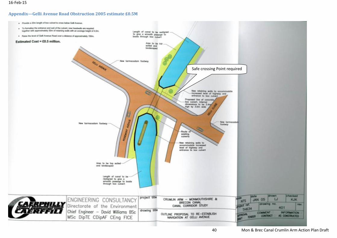
Tunnel replacing the Gelli Road Obstruction
Navigation Road to Moriah Chapel Bridge is the highest flood risk area. Removal of the Gelli Road obstruction by creating a tunnel to improve water flow and accommodate a narrow boat, would prevent the build up of rubbish at the culvert which has been slowing water flow and causes silt build up. This would help to reduce the flood issue and increase the navigable distance in the middle section. A safe road crossing point could run alongside the canal if tunnel height permits.
CCBC MBC Regen Partnership Skills development Community engagement
2005 £0.5M
Two way Tunnel Thistle Road obstruction
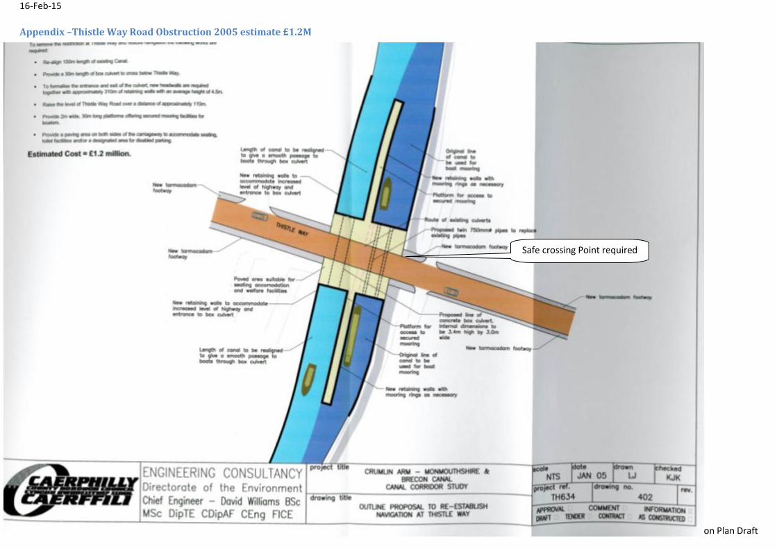
Removing the Thistle Road obstruction will increase the flow of water out of the higher risk areas. The creation of tunnels that would create a two way traffic system would benefit the long term navigational possibilities for the canal. A safe road crossing point could run alongside the canal if tunnel height permits.
CCBC MBC Regen Partnership Skills development Community engagement
2005 £1.2M
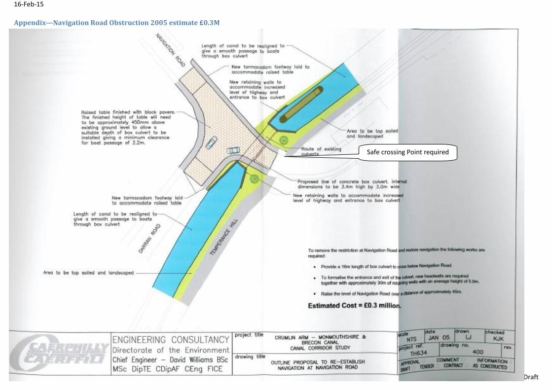
Tunnel Replacing the Navigation Road obstruction
Removing the Navigation Road obstruction would create a middle section of canal fully navigable from Manor Road to Darren Road. This would be of sufficient length to run a dinner cruise boat, and encourage other private and commercial boat use. A safe road crossing point could run alongside the canal if tunnel height permits.
CCBC MBC Regen Partnership Skills development Community engagement
2005 £0.3M
16-Feb-15
35 Mon & Brec Canal Crumlin Arm Action Plan Draft
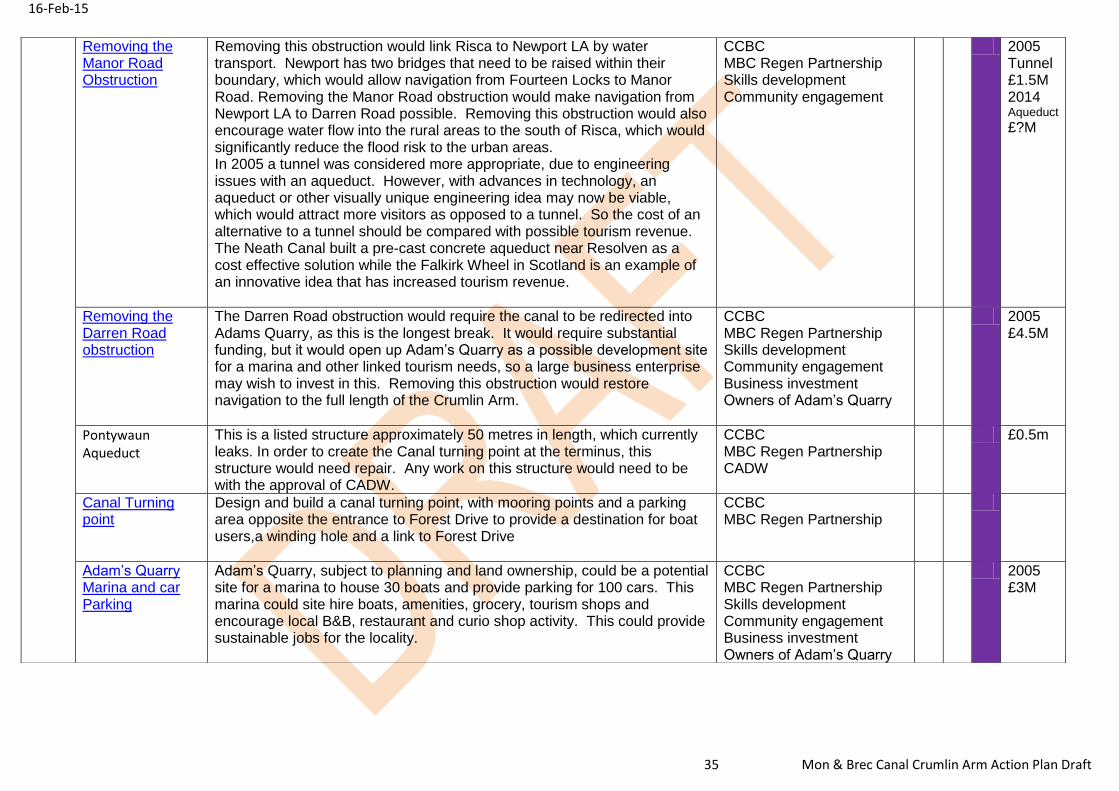
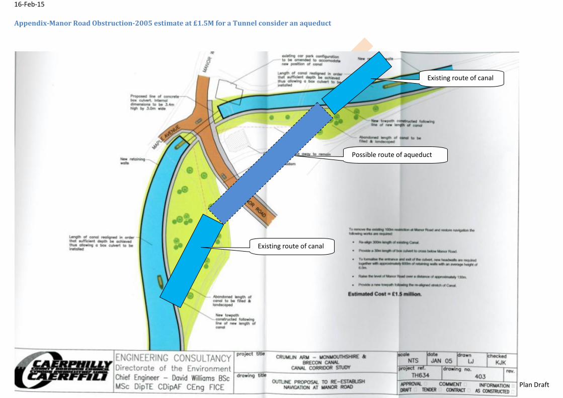
Removing the Manor Road Obstruction
Removing this obstruction would link Risca to Newport LA by water transport. Newport has two bridges that need to be raised within their boundary, which would allow navigation from Fourteen Locks to Manor Road. Removing the Manor Road obstruction would make navigation from Newport LA to Darren Road possible. Removing this obstruction would also encourage water flow into the rural areas to the south of Risca, which would significantly reduce the flood risk to the urban areas. In 2005 a tunnel was considered more appropriate, due to engineering issues with an aqueduct. However, with advances in technology, an aqueduct or other visually unique engineering idea may now be viable, which would attract more visitors as opposed to a tunnel. So the cost of an alternative to a tunnel should be compared with possible tourism revenue. The Neath Canal built a pre-cast concrete aqueduct near Resolven as a cost effective solution while the Falkirk Wheel in Scotland is an example of an innovative idea that has increased tourism revenue.
CCBC MBC Regen Partnership Skills development Community engagement
2005 Tunnel £1.5M 2014 Aqueduct
£?M
Removing the Darren Road obstruction
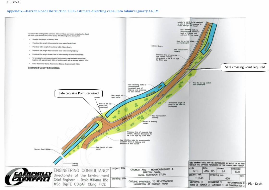
The Darren Road obstruction would require the canal to be redirected into Adams Quarry, as this is the longest break. It would require substantial funding, but it would open up Adam’s Quarry as a possible development site for a marina and other linked tourism needs, so a large business enterprise may wish to invest in this. Removing this obstruction would restore navigation to the full length of the Crumlin Arm.
CCBC MBC Regen Partnership Skills development Community engagement Business investment Owners of Adam’s Quarry
2005 £4.5M
Pontywaun Aqueduct
This is a listed structure approximately 50 metres in length, which currently leaks. In order to create the Canal turning point at the terminus, this structure would need repair. Any work on this structure would need to be with the approval of CADW.
CCBC MBC Regen Partnership CADW
£0.5m
Canal Turning point
Design and build a canal turning point, with mooring points and a parking area opposite the entrance to Forest Drive to provide a destination for boat users,a winding hole and a link to Forest Drive
CCBC MBC Regen Partnership
Adam’s Quarry Marina and car Parking
Adam’s Quarry, subject to planning and land ownership, could be a potential site for a marina to house 30 boats and provide parking for 100 cars. This marina could site hire boats, amenities, grocery, tourism shops and encourage local B&B, restaurant and curio shop activity. This could provide sustainable jobs for the locality.
CCBC MBC Regen Partnership Skills development Community engagement Business investment Owners of Adam’s Quarry
2005 £3M
16-Feb-15
36 Mon & Brec Canal Crumlin Arm Action Plan Draft
16-Feb-15
37 Mon & Brec Canal Crumlin Arm Action Plan Draft
Appendix- Site of proposed canoe store
Site of proposed canoe/boat store
Possible partnership with church
16-Feb-15
38 Mon & Brec Canal Crumlin Arm Action Plan Draft
Appendix-Proposed site of community area, footbridge, safe walk to Ty Sign School route
Canal Footbridge would connect walkway from Wood View
Road to rear Ty Sign School
Narrow wooded strip of land has potential as an outdoor
classroom, wooded play area, community BBQ site.
16-Feb-15
39 Mon & Brec Canal Crumlin Arm Action Plan Draft
Appendix-Turning circle and car park to link the canal to Cwmcarn Forest Drive.