Page 1 CS468515 Laser scanning -Enhancing Productivity & Quality in Construction Management Bimal Patwari Pinnacle Infotech Inc. Leonidas Pinnacle infotech Inc. Description This class will dive deep into how laser scanning is taking construction management into a new orbit. We will use Real-life case studies to demonstrate the use of laser scanning for the following: defection monitoring of structures; virtual erection of structural elements; deviation analysis of structures and systems; leveling and alignments; coordinate extraction and as-built management; cut-out management; progress monitoring; quantity surveying; and construction inspection. Innovations in the use of laser scanning is bringing a shift in construction management. The class will discuss case studies for each of the benefits mentioned above—how it is improving quality, reducing rework, lowering costs, improve site safety and time, and dramatically improving construction quality. Speaker Bimal Patwari is the 1st generation Entrepreneur and founder of Pinnacle Infotech Solutions, the acknowledged Global leader in providing innovative BIM solutions. Bimal is recognized for his contribution to the innovative use of BIM technology to improve efficiency and quality, reduce costs and wastages . He has received several awards and recognition from Government and other industry associations for his entrepreneurship and pioneering contribution to the construction industry. Learning Objectives Innovative use of laser scanning for o Improving construction quality o Improve site safety o Getting ahead of schedule Laser scanning for construction progress management Laser scanning for inspection and approvals Laser scanning for quantity estimation and contactor bill approval
Transcript
Page 1
CS468515
Laser scanning -Enhancing Productivity & Quality in Construction Management Bimal Patwari Pinnacle Infotech Inc. Leonidas Pinnacle infotech Inc.
Description
This class will dive deep into how laser scanning is taking construction management into a new
orbit. We will use Real-life case studies to demonstrate the use of laser scanning for the
following: defection monitoring of structures; virtual erection of structural elements; deviation
analysis of structures and systems; leveling and alignments; coordinate extraction and as-built
management; cut-out management; progress monitoring; quantity surveying; and construction
inspection. Innovations in the use of laser scanning is bringing a shift in construction
management. The class will discuss case studies for each of the benefits mentioned above—how
it is improving quality, reducing rework, lowering costs, improve site safety and time, and
dramatically improving construction quality.
Speaker
Bimal Patwari is the 1st generation Entrepreneur and founder of Pinnacle Infotech Solutions, the
acknowledged Global leader in providing innovative BIM solutions. Bimal is recognized for his
contribution to the innovative use of BIM technology to improve efficiency and quality, reduce
costs and wastages .
He has received several awards and recognition from Government and other industry
associations for his entrepreneurship and pioneering contribution to the construction industry.
Learning Objectives
Innovative use of laser scanning for o Improving construction quality o Improve site safety o Getting ahead of schedule
Laser scanning for construction progress management
Laser scanning for inspection and approvals Laser scanning for quantity estimation and contactor bill approval
Page 2
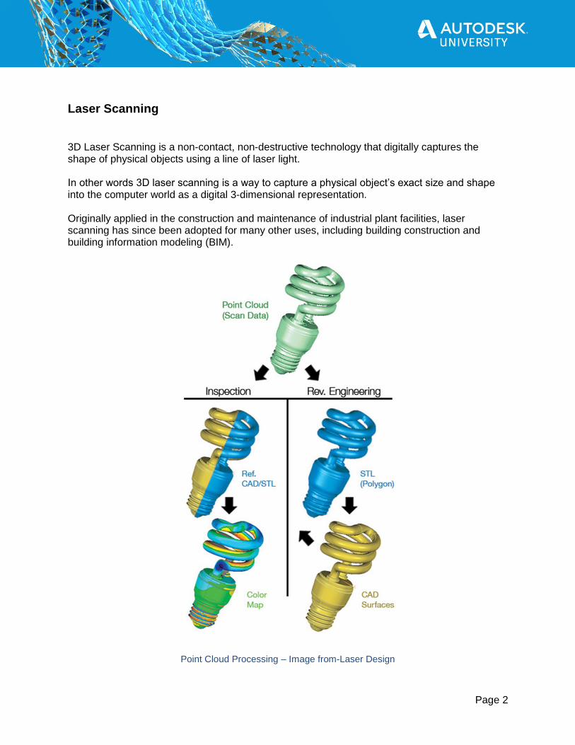
Laser Scanning
3D Laser Scanning is a non-contact, non-destructive technology that digitally captures the shape of physical objects using a line of laser light. In other words 3D laser scanning is a way to capture a physical object’s exact size and shape into the computer world as a digital 3-dimensional representation. Originally applied in the construction and maintenance of industrial plant facilities, laser scanning has since been adopted for many other uses, including building construction and building information modeling (BIM).
Point Cloud Processing – Image from-Laser Design
Page 3
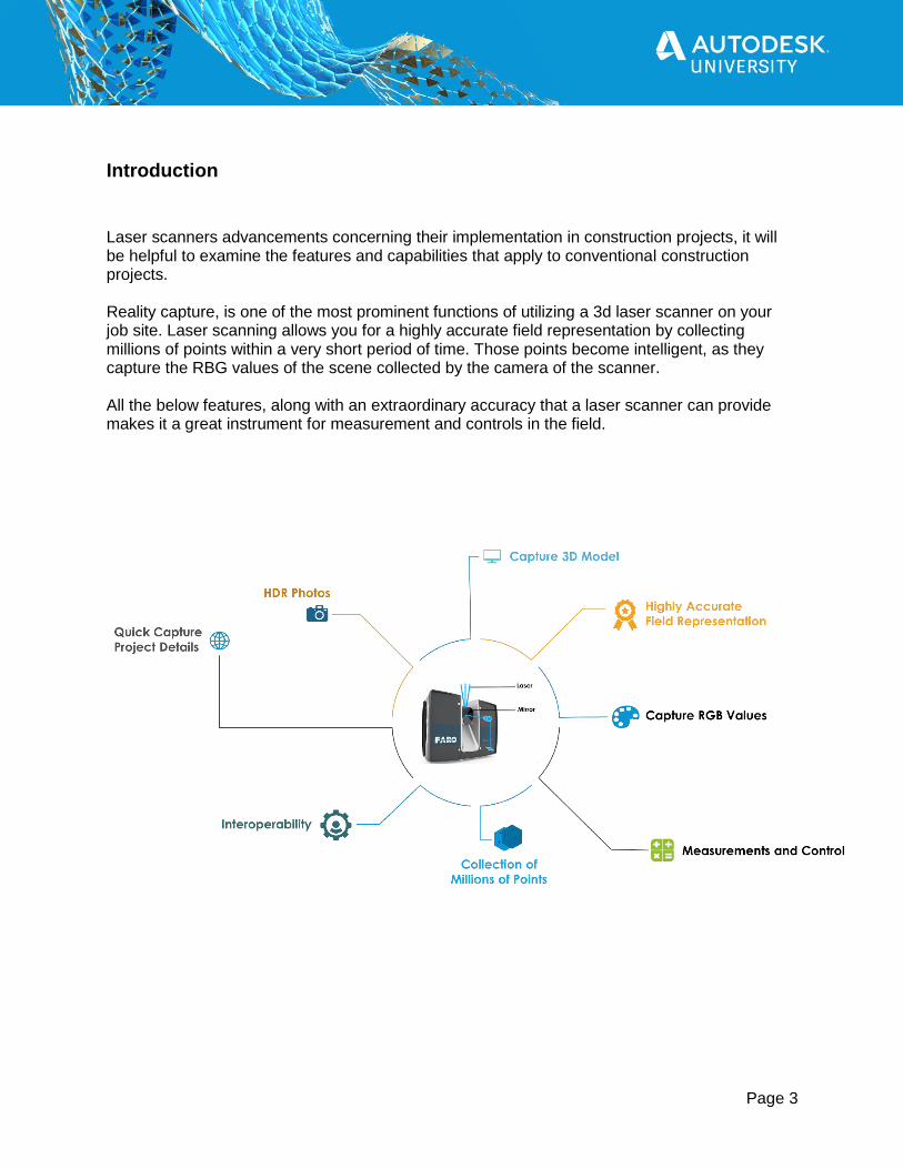
Introduction
Laser scanners advancements concerning their implementation in construction projects, it will be helpful to examine the features and capabilities that apply to conventional construction projects. Reality capture, is one of the most prominent functions of utilizing a 3d laser scanner on your job site. Laser scanning allows you for a highly accurate field representation by collecting millions of points within a very short period of time. Those points become intelligent, as they capture the RBG values of the scene collected by the camera of the scanner. All the below features, along with an extraordinary accuracy that a laser scanner can provide makes it a great instrument for measurement and controls in the field.
Page 4
Types of Scanners
The most common type of laser scanners used in the field of construction, is the LiDAR method. LiDAR is a method for measuring distances by illuminating the target with a laser light and measuring each reflection with a sensor. Differences in the laser returned times and wavelengths can be used for making a new digital 3d representation and usually are classified in following four main categories. Therefore LiDAR scanners can be airborne, stationary Terrestrials, mobile Terrestrials, and handheld. Each individual type is used for different purposes, needs, and range of accuracy according to the assigned task.
Airborne Laser Scanner
Stationary Terrestrial Laser Scanner
Mobile Terrestrial Laser Scanner
Handheld (Industrial)
Ideal Usage
Exterior mapping Long/Linear Projects Large scale mapping
Interior high-density high accuracy scans (MEP, architectural, structural, facilities management, and forensics)
Exterior high accuracy longer range scans (Architectural reconstruction, surveying, engineering, planning, forensics)
Top-quality, high-precision Its suitable for indoor scans
Accuracy and Range
Accuracy +/- 10 CM, depending on conditions Range 3.000 feet (typically flown at about 3,000 FT)
Accuracy +/-2MM Range 60 to 120 meters, depending on conditions
Accuracy +/-2MM Range 150 to 330 meters, depending on conditions
Accuracy +/-0.5mm Range up to 110 meters, depending on conditions
Scanners
Page 5
Benefits for General Contractors
3D laser scanning enables a fast and accurate means of collecting millions of measurable data points in seconds to provide pinpoint accuracy, every time.
For general contractors, this insight is the single largest benefit of laser scanning. Laser scanning helps lower contractor risks by ensuring as-built drawings are accurate and by exposing any inaccuracies early in the process, before they turn into change orders during construction.
Datasets are dimensionally accurate, measurable, and shareable, so you can eliminate any guesswork back at the office.
For detailed MEP installations, you need a high level of accuracy. If your project is complex, involves retrofits, or requires refurbishment, you can capture precise data over the full measurement range.
The benefits of laser scanning do not stop at preconstruction coordination. Scanning progressively during construction to compare with as-designed models and drawings, provide archival records, and document critical milestones provides tremendous value throughout the construction process as well as to the owner as the building is managed, maintained and renovated.
Laser Scanning Across A Project’s Lifecycle Design - When it comes to site design, 3D laser scanning is a starting point even sometimes
before BIM. Many professionals today are adopting a scan-to-BIM method of design to capture detailed information to kick off and manage the process early.
Construction - Construction coordination, specifically in avoiding conflicts between different
systems (i.e., HVAC, electrical, plumbing). Data can also be shared between parties to help with any remote coordination.
Operations - Scanning isn’t just performed at the beginning of a project either; it can be done
at various other points along the timeline to better document milestones, reduce the necessity of change orders and pass off work to other trades professionals.
Retrofits & Renovations - Laser scanning captures a very high level of detail, and this helps
create a permanent as-built record for both owners and facility managers. In the end, this data can help with building operations, renovations and future building additions and even demolitions.
Page 6
Laser Scan Registration Registration is the process of aligning multiple scans in a parent coordinate system using reference positions common between scans. References are common points between scans that are used to create a “best-fit” alignment. The X,Y,Z coordinate and point name are created on positions like the center of a sphere or planar scan target. The purpose of pairwise registration is to find a common contact surface and optimally align one of the scans relative to another. There are many algorithms for registration of two geometric surfaces that are the alternatives of the well-known Iterative Closest Point (ICP) algorithm
Concept of Registration
Actual Registration
Registered Output
Page 7
Laser Scanning Accuracy The difference of each single range measurement to the mean range-value is specified by the Range Noise.
Page 8
Point Cloud Processing Software
The processing software should be capable to register the number of laser scans at a time with a great accuracy. The noise elimination tools must be incorporated with the software which will help to remove the noise to combine the processed data very accurately
Faro Scene
Autodesk Recap Pro
Page 9
Benefits of Laser Scanning-
Construction Quality Management
Processing of millions of closely spaced points helps in capturing actual level and member orientation. Feedback from deviation analysis extracted by point cloud facilitates erection and minimize the overall tolerance of combine structure during the erection stage. It improves coordination and collaboration on jobsite, leading to faster and better decision-making.
Inspection and Approvals The overlay of the LOD 400 models versus the collected point cloud creates a composite model that clearly reflect the deviations between the as-designed and as-built stage.
Deviation Analysis
Page 10
Quantity Estimation Measuring quantity and maintaining the volume of stockpiles, cut & fill in heavy earthwork industries is difficult. Traditional survey methods are inaccurate and measure up to 80% of original volumes. Measuring a stockpile volume using 3D Laser Scanning is by far the fastest and safest method available.
Progress Monitoring Creation of construction progress model on timely basis is now easier with laser scanning. It creates a point cloud of each element of site. The progress models from every span of time create a clear vision of construction headways.
Page 11
As Built Preparation The practice of creating a digital representation of existing conditions of the building with its physical and functional characteristics in BIM. The point cloud need to import into a 3D BIM software (Autodesk’s Revit, Graphisoft’s ArchiCAD, etc.) in order to create accurate as-built models