Cuaternario y Geomorfología (2011), 25 (3-4), 59-69 59 Cuaternario y Geomorfología ISSN: 0214-174 www.rediris.es/CuaternarioyGeomorfologia/ Distribuon of bedrock channel erosion: micro and mesoforms in fluviokarsc canyons Distribución de la erosión en cauces excavados en roca madre: micro y mesoformas en los cañones fluviocárscos Sanchis, C. (1) ; Segura, F. (2) ; Rosselló V.M. (2) (1) Centre Valencià d’Estudis del Reg, Universitat Politècnica de València. [email protected](2) Departament de Geografia, Universitat de València. Abstract This paper examines erosional forms and processes in a calcareous bedrock channel, in the Tambuc rambla (Caroig plaorm, Valencia). The analysis of forms demonstrates the dominance of abrasion, erosion and quarrying over corrosion processes. The incision caused by channel flow (forming flutes, potholes and inner channels) has been more effecve than other produced by dissoluon (resulng in kamenitza and rillenkar- ren). The hydrodynamic processes, which are strongly structurally influenced, produce an irregular longitu- dinal profile with several knickpoints. Keywords: Bedrock channels, abrasion, evorsion, quarrying, kamenitza, potholes. Resumen En el presente trabajo se analizan las formas y los procesos de erosión del lecho de un meandro de la ram- bla del Tambuc, encajado en las calizas subtabulares de la plataforma del Caroig (Valencia). El análisis de las formas demuestra el predominio de procesos de abrasión, evorsión y remoción sobre los de corrosión. La incisión producida por el flujo del canal (en forma de surcos, marmitas de gigante y canales interiores) ha sido más efecva que la generada por procesos de disolución (manifiestos en cuencos y rillenkarren). El dominio de los procesos hidrodinámicos, fuertemente condicionados por la estructura, da como resultado la forma- ción de un perfil longitudinal irregular con numerosas rupturas de pendiente. Palabras clave: Lecho rocoso, abrasión, evorsión, remoción, cuencos de disolución, marmitas de gigante. Derechos de reproducción bajo licencia Creave Commons 3.0. Se permite su inclusión en repositorios sin ánimo de lucro.
Transcript
Cuaternario y Geomorfología (2011), 25 (3-4), 59-69
58 59
Cuaternario y GeomorfologíaISSN: 0214-174
www.rediris.es/CuaternarioyGeomorfologia/
Distributi on of bedrock channel erosion: micro and mesoforms in fl uviokarsti c canyons
Distribución de la erosión en cauces excavados en roca madre: micro y mesoformas en los cañones fl uviocársti cos
Sanchis, C.(1); Segura, F. (2); Rosselló V.M.(2)
(1) Centre Valencià d’Estudis del Reg, Universitat Politècnica de València. [email protected](2) Departament de Geografi a, Universitat de València.
Abstract
This paper examines erosional forms and processes in a calcareous bedrock channel, in the Tambuc rambla (Caroig platf orm, Valencia). The analysis of forms demonstrates the dominance of abrasion, erosion and quarrying over corrosion processes. The incision caused by channel fl ow (forming fl utes, potholes and inner channels) has been more eff ecti ve than other produced by dissoluti on (resulti ng in kamenitza and rillenkar-ren). The hydrodynamic processes, which are strongly structurally infl uenced, produce an irregular longitu-dinal profi le with several knickpoints.
En el presente trabajo se analizan las formas y los procesos de erosión del lecho de un meandro de la ram-bla del Tambuc, encajado en las calizas subtabulares de la plataforma del Caroig (Valencia). El análisis de las formas demuestra el predominio de procesos de abrasión, evorsión y remoción sobre los de corrosión. La incisión producida por el fl ujo del canal (en forma de surcos, marmitas de gigante y canales interiores) ha sido más efecti va que la generada por procesos de disolución (manifi estos en cuencos y rillenkarren). El dominio de los procesos hidrodinámicos, fuertemente condicionados por la estructura, da como resultado la forma-ción de un perfi l longitudinal irregular con numerosas rupturas de pendiente.
Palabras clave: Lecho rocoso, abrasión, evorsión, remoción, cuencos de disolución, marmitas de gigante.
Derechos de reproducción bajo licencia Creati ve Commons 3.0. Se permite su inclusión en repositorios sin ánimo de lucro.
Cuaternario y Geomorfología (2011), 25 (3-4), 59-69
60 61
1. Introduction
Bedrock channels have not been broadly ana-lysed in the literature when these are com-pared to alluvial channels. The difficulties in accessing these areas, the slowness of pro-cesses and the difficulties of laboratory simu-lation explain this lack of research. However, in recent years numerous publications have analysed the erosive mechanisms in bed-rock channels at different scales (Wolh, 1998; Richardson and Carling, 2005). The main erosional mechanisms include the following types: a) corrosion (by chemical weathering and/or dissolution), b) corrasion or abrasion produced by clasts moving along the channel as bedload or suspended load, c) plucking, quarrying and flaking, d) cavitation, e) evor-sion and f) physical and/or biological weath-ering (Richardson and Carling, 2005; Hancock and Anderson, 1998, Whipple et al., 2000). The erosive structures formed by these pro-cesses provoke feedbacks between forms geometry and flow hydraulics. The formation of these structures is the result of interac-tion between numerous variables and can be seen as a balance between erosive and resistant forces. The erosive forces include a) hydraulic forces, controlled by flow mag-nitude, frequency and duration; the channel gradient and the geometry of the transversal and longitudinal sections; b) sediment load characteristics: the size, volume and resist-ance of the bedload. Resistant forces are a function of substrate characteristics which include resistance to abrasion, compressive and shear strength, weathering, density and direction of discontinuities, porosity and per-meability, and homogeneity (Wohl and Ikeda, 1997). The combination of all these variables can produce similar structures even if they are formed in different types of rocks.
Allen’s pioneering experiments (1969) showed the progression from longitudinal grooves, flutes, transverse erosional marks and shear wrinkles when the Reynolds num-ber increased. It has been demonstrated that the spatial variability of substrate resist-ance plays an important role in the forma-
tion of knickpoints (Wohl and Ikeda, 1997) and bedrock ribs (Goode and Wohl, 2010). Highly fractured and fissured rocks promote plucking processes, whilst massive homoge-neous rocks encourage abrasion and the for-mation of flutes, potholes, inner channels, etc. (Whipple et al., 2000). However, the ef-fectiveness of abrasion is conditioned by the dual role of the bedload, which can act as an erosive agent or as a cover which inhibits in-cision, depending on the ratio between the amount of sediment and its transporting ca-pacity (Goode and Wohl, 2010). Recently, the important role slopes play in modelling bed-rock channels has been demonstrated. Thus, inner channels are formed with steep gradi-ents, suggesting that they maximise the ero-sional force by concentrating the flow (Wohl and Merrit, 2001).
This paper classifies the erosive forms of the 2 km length bedrock channel of the Tambuc rambla and explains the processes which have created them. In addition, the forms have been mapped and quantified in order to establish different erosive processes. Fi-nally, the factors that promote the appear-ance of the different forms and explains their hydrogeomorphological meaning are dis-cussed.
2. Study area
This paper analyses a 2 km length section of the Tambuc rambla, a tributary of the River Cazunta (517 km2, tributary of the River Xúquer, see Figure. 1). The drainage network forms meandering canyons which are deeply embedded into the calcareous Caroig plat-form (Segura et al., 2009), a set of subtabular reliefs made up of Jurassic and Cretaceous limestone. The top of the platform is formed by Santonian limestone, whilst the rambla exhumes and excavates its bed on limestone and marl strata from the Coniacian period. The study area is an ingrown meander sculpt-ed by a large variety of processes and forms. This type of meanders has a vertical face on the concave side whilst the convex side gen-tly slopes downward to the bedrock channel.
Cuaternario y Geomorfología (2011), 25 (3-4), 59-69
60 61
This study area has been selected because it has a uniform lithology, presenting a great va-riety of forms and is easily accessible.
The materials are highly fractured, with two major fracture lines which follow two pre-ferred directions: a) a dominant direction of 240º (25% - 33%), and b) a secondary direc-tion of 330º (between 6% and 18% at the observed points). This implies the existence of a rhombic network of fractures and joints on almost horizontal strata, which facilitates processes such as plucking and fracturing of the blocks. The Tambuc rambla is an ephem-eral stream, which only carries water after prolonged heavy rainfall (annual mean pre-cipitation in this area is around 500-550 mm). Ramblas usually carry water 2-3 times per year, although flow is scarce. There are not flow gauging stations in the Tambuc rambla, but exceptionally it can carry large flows, as occurred in October 1982, when the flow vol-
Figure 1. Study area of the Tambuc Rambla.Figura 1. Área de estudio de la Rambla del Tambuc.
ume of the Cazunta River was estimated be-tween 69 and 236 hm3 (Segura, 2009).
3. Methods
In order to identify the fluvial processes and forms, a topographical elevation survey was carried out using RTK-GPS, generating 50 cm contour levels from 11,018 elevation points with a residual error always smaller than 0.14 mm in planimetry (x and y) and 0.19 in elevation (z). Detailed topography was used to elaborate a Digital Elevation Model (DEM) with a pixel resolution of 2.5 m. In addition, a map of the bedrock channel’s forms was obtained based on this topography. All data were imported to a Geographic Information System (GIS) for further analysis. A morpho-metric analysis of two flute sections and frac-ture directions was carried out in the field. A longitudinal profile and different cross- sections were obtained from the DEM in or-
Cuaternario y Geomorfología (2011), 25 (3-4), 59-69
62 63
der to better characterise the channel forms. This was also used to analyse the channel slope.
4. Channel bed morphology
Channel bedrock is sculpted by different ero-sion and sedimentation processes. As intro-duced previously, in bedrock channels, the dominant erosion processes are: a) corrasion or abrasion (the second term will be in use for avoiding confusions) produced by sediment entrainment, b) evorsion c) plucking, quarrying and flaking, d) corrosion (by chemical weath-ering and/or dissolution) e) cavitation, and f) physical and/or biological weathering (Richard-son and Carling, 2005; Hancock and Anderson, 1998). The resultant forms can be produced by a dominant process or by the combination of several processes (e.g. inner channels).
4.1. Abrasion: flute marks and pseudo-ripples
Corrosion or mechanical abrasion weakens the surface through the impact of sediment transported in suspension or as bedload. It acts according to a series of variables: a) the resistance of clasts in transport relative to the resistance of the bedrock substrate, b) the grain size distribution and volume of transported sediment, c) the hydraulics of the flow, which determinate the location, magnitude and frequency of sediment and bedrock abrasive contacts. According to Wohl (1998), the highest abrasion ratios occur dur-ing floods, when turbulent waters are highly loaded with large amounts of sediment in suspension. In the studied reach, although we are not able to indentify themain forming factors, flute marks and pseudo-ripples are formed.
Figure 2. Flutes on a bedrock rib in the first zone. The arrow indicates flow direction. The graphic shows the change in the slope of the longitudinal section just upstream the flutes.
Figura 2. Acanaladuras (flutes) sobre un resalte transversal (bedrock rib) en el primer sector. La flecha indica la dirección del flujo. El gráfico muestra el cambio en el perfil longitudinal inmediatamente aguas arriba de las acanaladuras.
Cuaternario y Geomorfología (2011), 25 (3-4), 59-69
62 63
4.1.1. Flute marks
Although this is an ambiguous term used in different environments with diverse mean-ings (Richardson and Carling, 2005), in this paper it is used to describe discontinuous fur-rows parallel to the flow, with upstream rims that are parabolic in plan view. Although the origin of this type of erosive marks is subject to discussion, there is a certain consensus in that they are formed by the irregularity of the terrain (Allen, 1982; Hancock and Anderson, 1998), which causes flow separation and re-circulation. Flute marks appear in two zones in the area under study. In the first zone they are open erosive forms sculpted on a bedrock rib, located downstream of a depression and denote high flow energy (Figures 2 and 3). They are broad flutes and have a sharp rim at the proximal end but are only slightly concave at the distal end. These structures migrate upstream, eroding the transversal bedrock rib (remains of a harder stratum).
In the second section, the flutes are closed and have spindle-shape marks, which also
Table 1. Geometric characteristics of the flutes in each sector of the study reach.
Tabla 1. Dimensiones de las acanaladuras (cm).
Figure 3. Spindle-shaped flutes in the second zone.Figura 3. Acanaladuras en forma de huso en
el segundo sector.
facilitate their growth by dissolution. In two sectors, these flutes are parallel to the joints. They are around 10 cm long and several cen-timetres wide. Flutes require small irregulari-ties in the bedrock channel for their initiation. In the study area they are associated with fractures subsequently widened by the flow. The role of vegetation is not clear as this can be both a cause and a consequence of the generation of secondary flows. The morpho-metric analysis carried out in the field surveys shows that the flute marks in the first section are wider and deeper than those in the sec-ond section which are longer, narrower and shallower (around 4cm except for three ex-amples which measure over 20cm) (Table 1).
4.1.2. Pseudo-ripples
Pseudo-ripples are undulating forms of the bedrock channel, in which crests and troughs alternate. They are also known as hummocky forms in literature (Richardson and Carling, 2005) and are convex forms which appear in raised areas of the bedrock channel, and develop easily on fine grain materials. Ac-cording to Hancock and Anderson (1998), they derive from incipient sinuous crests at low amplitude which evolve towards sharp-er forms. Flutes and other concave erosive structures often develop on the sides of pseudo-ripples in subsequent phases. In the channel studied they are formed by round-ed crests whilst the bedload lodges in the troughs and vegetation grows in them. In the study area these structures are associated with a joint orthogonal network, which im-ply a structural influence. This structural pat-tern encourages differential erosion and the
Cuaternario y Geomorfología (2011), 25 (3-4), 59-69
64 65
formation of a smoothing and irregular sur-face. Dissolution also contributes to make depressions deeper (Figure 4). Pseudo-rip-ples or hummocky forms are especially com-mon and well developed in limestone (Rich-ardson and Carling, 2005).
4.2. Evorsion: Potholes
Although this term is not recognised by all authors, evorsion refers to erosion caused by vortices and eddies formed by turbulent flows as a result of abrasion of the solid par-ticles transported (Richardson and Carling, 2005). Potholes can be formed by the rotary movements of pebbles (grinders, as per Al-len, 1982), but also by the abrasion of sus-pended load (Richardson and Carling, 2005). The presence of potholes has been related to several factors: a) surface irregularities in the bedrock such as joints or bedding planes that can initiate flow separation and differential erosion; b) velocities that are high enough to
Figure 4. Pseudo-ripples are between 20 and 40 cm high in the area.Figura 4. Los pseudo-ripples presentan una altura que oscila entre 20 y 40 cm.
produce abrasion where bedload quantities are sufficient to provide abrasive tools but not sufficient to cover the streambed with a thick alluvial veneer; c) velocities sufficient to produce cavitation; and d) changes in down-stream gradient that facilitate hydraulic flow transitions and substrate erosion (Springer et al., 2006). Potholes have very different forms and coalescence is frequent. According to Springer et al. (2006), in cylindrical potholes, walls are more eroded than in floor potholes. Grinders thus play a least role to suspended sediment entrained within the vortices that occur in potholes. In the study there are three areas with elliptical-shaped potholes (Figures 5 and 8) which are at list over 1m in diameter and over 1m deep. In all cases, the coalescence of the potholes (Figure 5) has formed an inner channel, which develops by headward erosion. The resulting knickpoint generates the necessary turbulence to de-velop the potholes and to extend the inner channel.
Cuaternario y Geomorfología (2011), 25 (3-4), 59-69
64 65
4.3. Plucking, quarrying, flaking and hydraulic wedging
Plucking and quarrying are accompanied by lifting or sliding of blocks previously defined by a network of fractures and joints (Han-cock and Anderson, 1998). This is the most efficient channel erosion process when the distance between joints is small enough to allow fragmentation into blocks which can be transported by the flow. According to Hancock and Anderson (1998), the quarry-ing capacity of a river increases as the square of velocity, which implies that this process is more active during floods. This process is also more effective with high slopes and velocity, such as in constricted areas of channels and in knickpoints. These authors also add anoth-er little known process, hydraulic wedging, which prepares the blocks for quarrying. This process consists of the wedging of pebbles or of sand in the joints and fractures which act
Figure 5. A 4 meters depth pothole and subsequent inner channel.
Figura 5. Marmita de gigante de 4 m de profundidad y posterior canal interno formado por coalescencia.
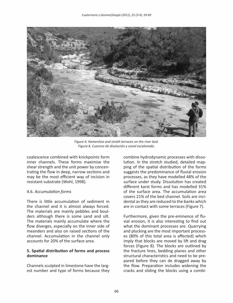
as a wedge thus destabilising the blocks. The mechanism requires large amounts of energy from the current for pebble wedging to occur. In the meander analysed in this paper, these processes predominate along the entire channel. The almost flat strata and the intri-cate network of orthogonal joints encourage fragmentation, so that as the process affects the different strata a side-stepped channel is formed giving rise to successive strath ter-races (Figure 6).
4.4. Corrosion: kamenitza and rillen-karren
The section of the rambla analysed is subject-ed to dissolution processes which are normal in limestone surfaces. Richardson and Carling (2005) differentiate between fluvial and non-fluvial solutional pits. In the first case, the forms follow the flow direction and can create fluvial forms such as potholes and undulat-ing surfaces. In the second case, dissolution forms are normally found in the raised parts of the channel, they are variably distributed and their forms are rough, as they have not been eroded by the flow. In the channel stud-ied, the most frequently found are non-fluvial forms such as kamenitza and rillenkarren (Al-len, 1982). Kamenitza are 0.1-0.5m wide and several centimetres deep, can be different-shaped (round, elongated, elliptical, irregular, etc.) and are highly conditioned by lines of weakness (joints and fractures). They evolve by coalescence (Figure 6) and sometimes are found with some types of rillenkarren. In the evolution of the bedrock channel there are also signs of the collapse of karstic galleries which leave hollows in the channel wall.
4.5. Inner channels and knickpoints
The result of the erosion is the formation of sudden breaks of slope (knickpoints) in the riv-er profile. These knickpoints retreat by head-ward erosion and occur where the greatest amount of energy dissipates. The distribution of the knickpoints is related to the frequency of joints, lithologic layering and the relations between strata dip and stream flow direction (Wohl, 1998). In the study area the potholes
Cuaternario y Geomorfología (2011), 25 (3-4), 59-69
66 67
Figure 6. Kamenitza and strath terraces on the river bed.Figura 6. Cuencos de disolución y canal escalonado.
coalescence combined with knickpoints form inner channels. These forms maximise the shear strength and the unit power by concen-trating the flow in deep, narrow sections and may be the most efficient way of incision in resistant substrate (Wohl, 1998).
4.6. Accumulation forms
There is little accumulation of sediment in the channel and it is almost always forced. The materials are mainly pebbles and boul-ders although there is some sand and silt. The materials mainly accumulate where the flow diverges, especially on the inner side of meanders and also on raised sections of the channel. Accumulation in the channel only accounts for 20% of the surface area.
5. Spatial distribution of forms and process dominance
Channels sculpted in limestone have the larg-est number and type of forms because they
combine hydrodynamic processes with disso-lution. In the stretch studied, detailed map-ping of the spatial distribution of the forms suggests the predominance of fluvial erosion processes, as they have modelled 48% of the surface under study. Dissolution has created different karst forms and has modelled 31% of the surface area. The accumulation area covers 21% of the bed channel. Soils are inci-dental as they are reduced to the banks which are in contact with some terraces (Figure 7).
Furthermore, given the pre-eminence of flu-vial erosion, it is also interesting to find out what the dominant processes are. Quarrying and plucking are the most important process-es (80% of this total area is affected) which imply that blocks are moved by lift and drag forces (Figure 8). The blocks are outlined by the fracture lines, bedding planes and other structural characteristics and need to be pre-pared before they can de dragged away by the flow. Preparation includes widening the cracks and sliding the blocks using a combi-
Cuaternario y Geomorfología (2011), 25 (3-4), 59-69
66 67
nation of hydraulic forces, the impact of the bedload, the wedging effect of particles in the cracks and different types of weathering (Richardson and Carling, 2005). This is typical of structurally controlled channels and im-plies that turbulence and the force of suction are of great importance. The relevance of this process is explained because joint spacing, fractures and bedding planes exert the most direct control. The blocks are affected by frac-tures which are well spaced enough to create clasts which can be moved by the flow. Whip-ple et al. (2000) indicate that plucking domi-nates wherever rocks are well jointed on a submeter scale and the initial block extraction rate scale with mean shear stress is beyond a critical value. Mechanical abrasion and evor-sion imply weakening the surface through the impact of sediment transported in suspen-sion or as bedload. Whipple et al. (2000) con-sider that where rocks are massive or joints are widely spaced plucking is inhibited and abrasion is more effective. They also suggest that the critical joint spacing for the transition from abrasion to plucking processes increases with channel gradient and bankfull discharge.
Mechanical abrasion (including evorsion) af-fects almost 20% of the hydrodynamically eroded surface (Figure 8). It acts according to a series of variables: a) the ratio between the resistance of the dragged clasts and the resistance of the substrate, b) the type and amount of sediment transported and c) flow hydraulics which determine the location, size and frequency of the abrasive contacts. Ac-cording to Wohl (1998), the highest abrasion ratios take place during floods with turbulent waters with large amounts of sediment in suspension. However, the presence/absence of bedload is subject to discussion. Although bedrock rivers are characterised by a lack of bedload, its presence is necessary for abra-sion and plucking mechanisms as impacts by saltating bedload and wedging of small peb-bles into existing joints play a key role in the initiation of these processes. Bedload abra-sion may be more important in less power-ful river systems where bedload dominates (Sklar and Dietrich, 1998; Whipple et al.,
Figure 7. Spatial distribution of hydrogeomorphological processes.
Figura 7. Distribución espacial de los procesos hidrogeomorfológicos.
2000), for instance in ephemeral streams such as the rambla del Tambuc. Percentages of forms produced by these processes stand 3% for flutes and potholes and 7% for inner channels and pseudo-ripples (Figure 8).
Cavitation occurs when changes in flow ve-locity lead to pressure fluctuations which cause the formation and collapse of water-vapour bubbles. The shock waves generated by this collapse can weaken the rock and it is a common phenomenon in reservoir over-flow channels. Although literature on this topic abounds we have not found any such forms in the studied stretch. In addition to cavitation, other hydrodynamic forces, such as turbulence and the force of suction, con-tribute to plucking and quarrying, especially in bedrock made up of bedding planes and/or very affected by fracturing. This is of vi-tal importance at a large scale as this is the process which prepares quarrying. Physical weathering acts in very different ways but in the case of ephemeral streams the wetting/drying cycles and the occasional freezing and thawing cycles are especially important. Biological weathering is particularly relevant in our case study as vegetation: a) gets into the cracks and small holes, thus encouraging the fragmentation and disintegration of the blocks as a result of root pressure; and b) pro-motes flow separation necessary for abrasion processes.
Cuaternario y Geomorfología (2011), 25 (3-4), 59-69
68 69
6. Discussion and final remarks
Erosive structures in bedrock channels are common to different lithologies. However, calcareous rocks are highly conditioned by dissolution processes, although their impor-tance in their modelling depends on the rocks texture and structure, on the existence and direction of joints, the rocks permeability and resistance, etc. For example, dissolution is the dominant process in the Migjorn canyons in Minorca, which are made out of Miocene reef limestone that has little resistance and is highly permeable (Segura et al., 2009). In the study area of the rambla del Tambuc, however, accumulation areas alternate with incision sections, the latter of which combine processes of dissolution, plucking and abra-sion. The 2km channel length is dominated by abrasion and other fluvial processes, with a large number of fractured blocks, potholes, flutes, inner channels and knickpoints. It is difficult to discern what the causes of these changes are. The first issue is the role of bed-load in the generation of sculpted forms. In the area under study, large size materials predominate (mainly pebbles and boulders) and make up about 80-90% of the total. Giv-en the surface area affected by the different processes, bedload probably plays a more important role in modelling the channel than sediment in suspension (Sklar and Dietrich, 2004). However, the size of structures such as flutes and pseudo-ripples are more compat-
ible with abrasion caused by suspended load, although this subject requires more detailed research.
Another interesting issue is the role dissolu-tion plays in the channel evolution. Although large areas are affected by corrosion, it must be pointed out that these areas are in the highest parts of the channel, mainly on the strath terraces affected by plucking and a long way away from the thalweg. Their per-sistence suggests that these areas are not frequently affected by floods, as these would destroy them. Moreover, the shallowness of the dissolution forms suggests that this is a secondary process in the channel modelling at this time. However, the existence of dis-sected galleries in the canyon walls suggests at a geological scale that karstic collapse can increase rapidly incision.
It is difficult to differentiate between the fac-tors which cause the abrasion and plucking processes, although it is obvious that litho-logical and structural characteristics play an important role. Plucking predominates where fracturing has a decimetric scale (10-15 cm) on the horizontal and vertical planes. How-ever, observations in the field suggest that where potholes and inner channels develop the strata are thicker, although decimetric fracturing continues on the horizontal plane.
Processes Area Average Standard (m2) slope (o) deviation
Table 2. Slope of forms and processes mapped in the study area.
Tabla 2. Pendiente de las formas y procesos cartografiados en el área de estudio.
Figure 8. Spatial distribution of abrasion processes.Figura 8. Distribución espacial de los procesos de
abrasión.
Cuaternario y Geomorfología (2011), 25 (3-4), 59-69
68 69
This means that the blocks likely to be af-fected by plucking should have decimetric dimensions on both the horizontal and verti-cal planes. When bedding planes are thickest, plucking is replaced by abrasion, which rein-forces the hypothesis of Whipple et al. (2000) when they state that this process affects more massive rocks. The role played by the gradient in the channel studied is difficult to assess. The accumulation areas logically cor-respond to the lower slopes (average value of 4.9º) whilst karst topography affects sharper gradients (7.0º). The flutes and pseudo-rip-ples are found on slopes with an 8º gradient, whereas potholes present slopes with a 10º gradient (Table 2).
Finally, plucking areas are found on the chan-nel banks, in raised areas, where they can only be affected by bankfull floods, which happens on very few occasions. This shows that this process is only viable with extraor-dinary flows which are also those with the greatest erosive capacity. A similar conse-quence is suggested by the location of the karst-affected surfaces. Their survival demon-strates the scarce flow in these areas which are probably only affected by major floods. Conversely, the areas affected by abrasion are found in the lowest parts of the thalweg which suggests that these processes can take place even when the flow is scarce.
Acknowledgments
This work was supported by Research projects CGL2006-11242-C03-02 and CGL2009-14220-C02-02, from Minis-terio de Ciencia e Innovación and financed with FEDER funds.
References
Allen, J. R. L. (1969). Erosional current marks of weakly cohesive mud beds. Journal of Sedimentary Pe-trology, 39, 607-623.
Allen, J. R. L. (1982). Sedimentary structures. 2 vols., El-
sevier, Amsterdam. 593 pp. Goode, J.R.; Wohl, E. (2010). Coarse sediment trans-
port in a bedrock channel with complex bed to-pography. Water Resources Research, 46 (11), W11524, 1-14.
Hancock, G. S.; Anderson, R. S. (1998). Beyond power: bedrock river incision process and form. In: Riv-ers over rock: fluvial processes in bedrock chan-nels (K.J. Tinkler; E.E. Wohl, eds.). American Geo-physical Union, Washington, 35-60.
Richardson, K.; Carling, P. A. (2005). A typology of sculpted forms in open bedrock channels. The Geological society of America, special Paper 392, GSA Books Science ed., 105 pp.
Segura, F. (2009). La pantanada de Tous, 25 anys de-sprés. VIII Jornades d’Estudis de Cullera, 23-25 nov. 2007. Ajuntament de Cullera, 10-40.
Segura, F; Fornós, J; Rosselló, V. M.; Pardo, J. E.; San-chis, C. (2009). Cañones fluviocársticos mean-drizantes: procesos y formas. Congreso Inter-nacional sobre Desertificación en memoria del Profesor John B. Thornes. Universidad de Murcia, 493-496.
Sklar, L. S.; Dietrich, W. E. (1998). River longitudinal pro-files and bedrock incision models: Stream power and the influence of sediment supply. In: Rivers over rock: fluvial processes in bedrock channels (K.J. Tinkler; E.E. Wohl, eds.). American Geophys-ical Union, Washington, pp. 237-260.
Sklar, L. S.; Dietrich, W.E. (2004). A mechanistic model for river incision into bedrock by saltating bed load. Water Resources Research, 40, W06301, 1-21.
Springer, G S; Tools, T.; Wohl, T.T. (2006). Theoretical modelling of stream potholes based upon em-pirical observations from the Orange River, Re-public of South Africa. Geomorphology, 82 (1/2), 160-176.
Whipple, K.X.; Hancock, G.S.; Anderson, R.S. (2000). River incision into bedrock: Mechanics and rela-tive efficacy of plucking, abrasion, and cavitation. Bulletin of the Geological Society of America, 112 (3), 490-503.
Wohl, E. (1998). Bedrock channel morphology in rela-tion to erosional processes. In: Rivers over rock: fluvial processes in bedrock channels (K.J. Tinkler; E.E. Wohl, eds.). American Geophysical Union, Washington, 133-15.
Wohl, E.; Ikeda, H. (1997). Experimental simulation of channel incision into a cohesive substrate at var-ying gradients. Geology, 25 (4), 295-298.
Wohl, E.E.; Merritt, D.M. (2001). Bedrock channel mor-phology. Bulletin of the Geological Society of America, 113 (9), 1205-1212.