1 Cullowhee Community Planning Area Proposed Development Standards Recommended by Cullowhee Community Planning Advisory Committee 01/15/15 TABLE OF CONTENTS NOTE: Page numbers will be added to final document ARTICLE I. AUTHORITY, PURPOSE, JURISDICTION, AND LEGAL STATUS PROVISIONS Sec. 1-1. Authority; title............................................................................................................ Sec. 1-2. Purpose....................................................................................................................... Sec. 1-3. Jurisdiction ................................................................................................................. ARTICLE II. OFFICIAL MAP, RULES OF CONSTRUCTION, AND DEFINITIONS Sec. 2-1. Official zoning maps; identification .......................................................................... Sec. 2-2. Interpretation of district boundaries ........................................................................... Sec. 2-3. General rules of construction ..................................................................................... Sec. 2-4. Conflict or inconsistency with other laws, covenants, or deed restrictions ............... Sec. 2-5. Definitions.................................................................................................................. ARTICLE III. DECISION-MAKING, ADMINISTRATIVE AND ADVISORY BODIES Sec. 3-1. Jackson County Board of Commissioners ................................................................. Sec. 3-2. Jackson County Planning Board ................................................................................ Sec. 3-3. Cullowhee Community Planning Council ................................................................. ARTICLE IV. GENERAL AND CONDITIONAL USE DISTRICTS ............................................. Sec. 4-1. Enumeration and description of districts; designation of districts on official zoning map .................................................................................................... Sec. 4-2. C Commercial District ............................................................................................... Sec. 4-3. I Institutional District ................................................................................................. Sec. 4-4. MFH Multi-Family Residential - High Density District ........................................... Sec. 4-5. MFM Multi-Family Residential - Medium Density District ..................................... Sec. 4-6. TH Townhome Residential - Low Density District ................................................... Sec. 4-7. SF Single Family Residential District........................................................................ Sec. 4-8. SF Single Family Residential – MH District ............................................................. Sec. 4-9. P/OS Parks/Open Space District ................................................................................ Sec. 4-10. Conditional Zoning Districts...................................................................................... ARTICLE V. CONDITIONAL USES AND USES SUBJECT TO SPECIAL REQUIREMENTS . Sec. 5-1. Uses by right, subject to special requirements ........................................................... Sec. 5-2. Conditional Uses ........................................................................................................ Sec. 5-3. Planned Developments...............................................................................................
Transcript
1
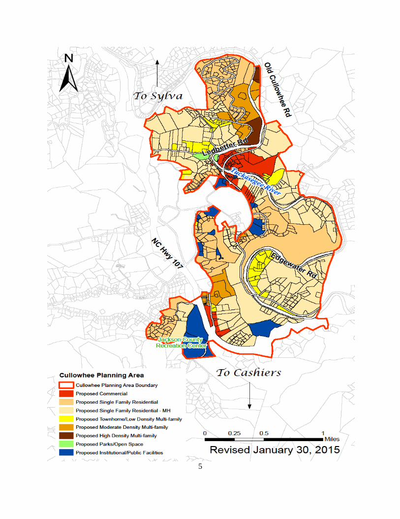
Cullowhee Community Planning Area
Proposed Development Standards
Recommended by Cullowhee Community Planning Advisory Committee 01/15/15
TABLE OF CONTENTS
NOTE: Page numbers will be added to final document
ARTICLE I. AUTHORITY, PURPOSE, JURISDICTION, AND LEGAL STATUS
PROVISIONS
Sec. 1-1. Authority; title ............................................................................................................
Sec. 1-2. Purpose .......................................................................................................................
Sec. 1-3. Jurisdiction .................................................................................................................
ARTICLE II. OFFICIAL MAP, RULES OF CONSTRUCTION, AND DEFINITIONS
Sec. 2-1. Official zoning maps; identification ..........................................................................
Sec. 2-2. Interpretation of district boundaries ...........................................................................
Sec. 2-3. General rules of construction .....................................................................................
Sec. 2-4. Conflict or inconsistency with other laws, covenants, or deed restrictions ...............
Sec. 2-5. Definitions..................................................................................................................
ARTICLE III. DECISION-MAKING, ADMINISTRATIVE AND ADVISORY BODIES
Sec. 3-1. Jackson County Board of Commissioners .................................................................
Sec. 3-2. Jackson County Planning Board ................................................................................
Sec. 3-3. Cullowhee Community Planning Council .................................................................
ARTICLE IV. GENERAL AND CONDITIONAL USE DISTRICTS .............................................
Sec. 4-1. Enumeration and description of districts; designation of districts on
official zoning map ....................................................................................................
Sec. 4-2. C Commercial District ...............................................................................................
Sec. 4-3. I Institutional District .................................................................................................
Sec. 4-4. MFH Multi-Family Residential - High Density District ...........................................
Sec. 4-5. MFM Multi-Family Residential - Medium Density District .....................................
Sec. 4-6. TH Townhome Residential - Low Density District ...................................................
Sec. 4-7. SF Single Family Residential District........................................................................
Sec. 4-8. SF Single Family Residential – MH District .............................................................
Sec. 4-9. P/OS Parks/Open Space District ................................................................................
Sec. 4-10. Conditional Zoning Districts......................................................................................
ARTICLE V. CONDITIONAL USES AND USES SUBJECT TO SPECIAL REQUIREMENTS .
Sec. 5-1. Uses by right, subject to special requirements ...........................................................
Sec. 5-2. Conditional Uses ........................................................................................................
Sec. 5-3. Planned Developments...............................................................................................
2
ARTICLE VI. DEVELOPMENT STANDARDS .............................................................................
Sec. 6-1. General .......................................................................................................................
Sec. 6-2. Traffic impact analysis ...............................................................................................
Sec. 6-3. Landscaping and buffering standards ........................................................................
Sec. 6-4. Parking, loading, and access standards ......................................................................
Sec. 6-5. Stormwater management standards ...........................................................................
Sec. 6-6. Architectural design standards ...................................................................................
Sec. 6-7. Flexible development standards .................................................................................
ARTICLE VII. SIGN REGULATIONS ............................................................................................
Sec. 7-1. Purpose and scope ......................................................................................................
Sec. 7-2. General provisions .....................................................................................................
Sec. 7-3. Prohibited signs ..........................................................................................................
Sec. 7-4. On-premise signs .......................................................................................................
Sec. 7-5. Maintenance ...............................................................................................................
Sec. 7-6. Structural and construction requirements ..................................................................
Sec. 7-7. Nonconforming signs .................................................................................................
Sec. 7-8. Variances....................................................................................................................
ARTICLE VIII. DEVELOPMENT REVIEW PROCEDURES ........................................................
Sec. 8-1. Permits and approvals ................................................................................................
Sec. 8-2. Zoning permits ...........................................................................................................
Sec. 8-3. Temporary Use Permit ...............................................................................................
Sec. 8-4. Conditional Use Permits ............................................................................................
Sec. 8-5. Design review ............................................................................................................
Sec. 8-6. Sign permits ...............................................................................................................
Sec. 8-7. Notices .......................................................................................................................
ARTICLE IX. VARIANCES AND ADMINISTRATIVE APPEALS .............................................
Sec. 9-1. Variances....................................................................................................................
Sec. 9-2. Appeals of administrative decisions ..........................................................................
ARTICLE X. TEXT AND MAP AMENDMENTS ..........................................................................
Sec. 10-1. General .......................................................................................................................
Sec. 10-2. Initiation of amendments ...........................................................................................
Sec. 10-3. Petition Requirements ................................................................................................
Sec. 10-4. Review by the Cullowhee Community Planning Council .........................................
Sec. 10-5. Review by the Jackson County Planning Board ........................................................
Sec. 10-6. Review by the Jackson County Board of Commissioners .........................................
Sec. 10-7. Waiting period for subsequent applications ...............................................................
ARTICLE XI. NONCONFORMING LOTS, SIGNS, STRUCTURES, AND USES ......................
Sec. 11-1. General .......................................................................................................................
Sec. 11-2. Non-conforming Lots.................................................................................................
Sec. 11-3. Non-Conforming Structures.......................................................................................
Sec. 11-4. Non-Conforming Uses ...............................................................................................
Sec. 11-5. Replacement of Manufactured Homes.......................................................................
Sec. 11-6. Maintenance and Repair of Non-Conforming Structures ..........................................
Sec. 11-7. Non-Conforming Signs ..............................................................................................
3
ARTICLE XII. ENFORCEMENT
Sec. 12-1. Duties regarding enforcement ....................................................................................
Sec. 12-2. Penalties for violations ...............................................................................................
Sec. 12-3. Notice of violation and citation procedure ................................................................
Sec. 12-4. Action for recovery of civil penalty; action for institution of criminal process ........
Sec. 12-5. Summary removal of temporary uses/structures; remove orders for temporary
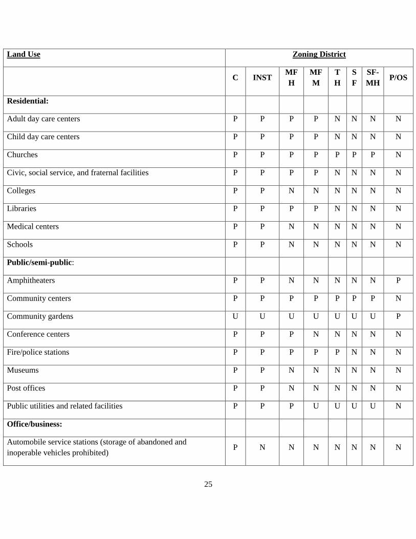
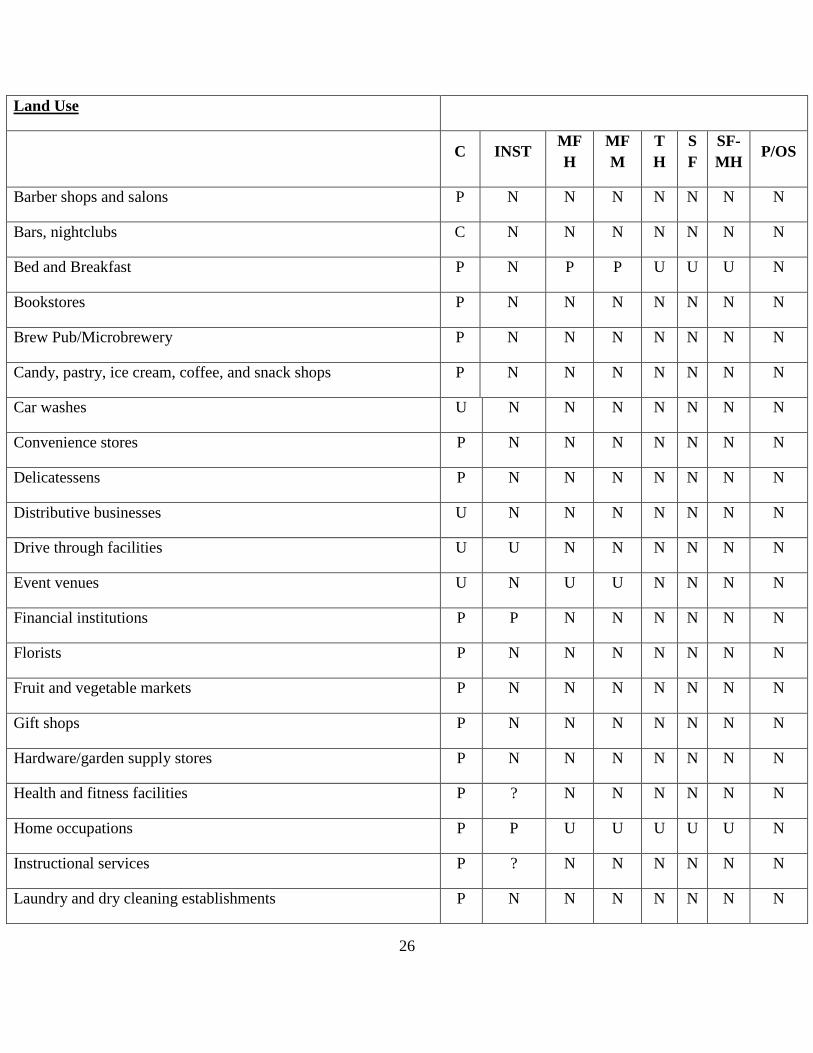
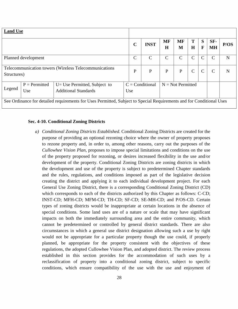
(1) Shall be subject to the Jackson County Telecommunications Ordinance
(2) Conditional use in the SF and TH districts
Sec. 5-3. Planned Developments.
The goal of the Planned Development provisions is to encourage flexibility in the development
of land and to provide tools and incentives for achieving this flexibility. Use of the Planned
Development option will result in the more efficient and economical use of land and resources.
A mixture of uses and building types is permitted in Planned Developments, subject to
limitations noted below. Incentives are provided to achieve goals related to the more efficient
use of resources. The Planned Development provisions allow greater flexibility in design but
may have conditions attached during the approval process. Approval of planned developments
40
by the Cullowhee Community Planning Council in accordance with the procedure set forth
below is required.
a) Permitted Use
(1) Planned Developments in non-residential districts – any use identified as a
permitted use in any district in the Cullowhee Planning Area with the exception of
single family home.
(2) Planned Developments in residential districts - any use identified as a permitted
use in any district in the Cullowhee Planning Area provided that the gross square
footage of all non-residential uses shall not exceed 15% of the total gross square
footage of all uses.
b) Minimum Lot Size. The minimum lot size for a planned development shall be one acre.
Within the planned development there shall be no minimum lot size for individual
structures.
c) Density. The base residential density shall be 125% of the residential density of the
district in which the planned development is proposed. Residential density may be
increased above the permitted base residential density in accordance with the incentives
identified below.
(1) Open space exceeds the requirements of this ordinance – see section 5-3.j) below
(2) Best management practices, such as bioretention and rain gardens, are used to
manage stormwater quality – density increase of 5%
(3) No grading or development of areas with a slope in excess of 30% - density
increase of 5%
(4) All residential, commercial, and/or mixed use buildings in the planned
development achieve an energy star rating – density increase of 5%
(5) Landscaping of parking areas exceeds the requirement by 50% – density increase
of 5%
d) Building Height. The base building height in a Planned Development shall be 40 feet.
The Planning Council may approve a building height of up to 80 feet provided that the
increased height is compatible with the surrounding neighborhood and does not adversely
impact adjacent uses.
e) Setbacks. The perimeter setbacks for the Planned Development shall be the setbacks for
the district in which the development is located. Within the Planned Development there
shall be no setbacks other than those required by building and/or fire code standards.
f) Impervious Surface. The Planned Development shall comply with the impervious surface
limits of the district in which it is located. Impervious surfaces may be increased if best
41
management practices (i.e. non-structural stormwater controls such as grassed swales and
rain gardens) are used to manage and retain stormwater. The permitted increase in
impervious surfaces shall be on a 2:1 ratio basis. For example, if 10% of the total
stormwater generated by the development’s impervious surfaces is managed and retained
through the use of best management practices, a 5% increase in the permitted impervious
surfaces shall be allowed; if 60% of the total stormwater generated by the development’s
impervious surfaces is managed and retained, a 30% increase in the permitted impervious
surfaces shall be permitted. This ratio ensures that there is a net decrease in the amount of
stormwater and pollutants generated from a development. Stormwater retention systems
shall be designed by a licensed engineer or landscape architect and their installation and
construction certified by the designer. Standing water and installations that allow for
water to collect and stagnate so as to provide a suitable breeding ground for vectors (e.g.
mosquitoes) and pathogens should be prohibited.
g) Landscaping and Buffering Standards. The Planned Development shall be buffered from
abutting properties as required by the landscaping standards set forth in Section 6-3. The
type of buffering required shall be determined by the use within the Planned
Development that is adjacent to the abutting property. Within the Planned Development
parking lots shall be landscaped and street trees provided as required by Section 6-3.
Dissimilar uses within the Planned Development shall be buffered from as each other as
required by the buffering requirements of Section 6-3.
h) Parking and Loading Standards. Parking and loading areas shall be provided as required
by Section 6-4 of this ordinance
i) Pedestrian Facilities. A sidewalk or approved pedestrian trail shall be provided along all
streets abutting the property on which the Planned Development is located. Sidewalks
and/or approved pedestrian trails shall connect all uses within the Planned Development.
Within parking areas constructed as part of a Planned Development, pedestrian
connections shall be provided to allow the safe movement of pedestrians through the
parking area. Pedestrian connections shall be provided from any sidewalk or pedestrian
facility abutting a street or road to the main entrance of any non-residential building,
mixed use building, and/or any multi-family residential building.
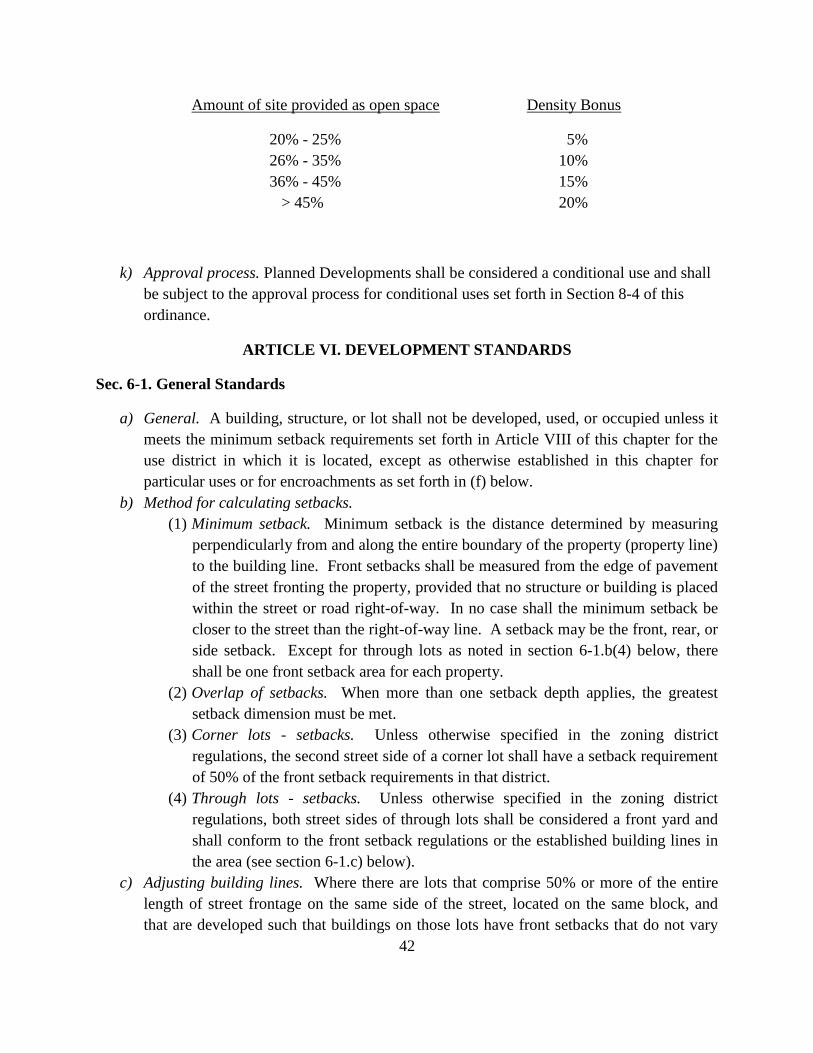
j) Open Space. A minimum of 15% of the total land area of the Planned Development shall
be set aside as open space. Density bonuses shall be provided for the provision of open
space exceeding the minimum amount as follows:
42
Amount of site provided as open space Density Bonus
20% - 25% 5%
26% - 35% 10%
36% - 45% 15%
> 45% 20%
k) Approval process. Planned Developments shall be considered a conditional use and shall
be subject to the approval process for conditional uses set forth in Section 8-4 of this
ordinance.
ARTICLE VI. DEVELOPMENT STANDARDS
Sec. 6-1. General Standards
a) General. A building, structure, or lot shall not be developed, used, or occupied unless it
meets the minimum setback requirements set forth in Article VIII of this chapter for the
use district in which it is located, except as otherwise established in this chapter for
particular uses or for encroachments as set forth in (f) below.
b) Method for calculating setbacks.
(1) Minimum setback. Minimum setback is the distance determined by measuring
perpendicularly from and along the entire boundary of the property (property line)
to the building line. Front setbacks shall be measured from the edge of pavement
of the street fronting the property, provided that no structure or building is placed
within the street or road right-of-way. In no case shall the minimum setback be
closer to the street than the right-of-way line. A setback may be the front, rear, or
side setback. Except for through lots as noted in section 6-1.b(4) below, there
shall be one front setback area for each property.
(2) Overlap of setbacks. When more than one setback depth applies, the greatest
setback dimension must be met.
(3) Corner lots - setbacks. Unless otherwise specified in the zoning district
regulations, the second street side of a corner lot shall have a setback requirement
of 50% of the front setback requirements in that district.
(4) Through lots - setbacks. Unless otherwise specified in the zoning district
regulations, both street sides of through lots shall be considered a front yard and
shall conform to the front setback regulations or the established building lines in
the area (see section 6-1.c) below).
c) Adjusting building lines. Where there are lots that comprise 50% or more of the entire
length of street frontage on the same side of the street, located on the same block, and
that are developed such that buildings on those lots have front setbacks that do not vary
43
more than 10', no building hereafter erected or structurally altered shall be required to
have a front setback greater than the average front setback depth of those lots. Provided
further, no front setback need exceed the average setback of the adjoining buildings on
either side, if the adjoining buildings are less than 250' apart
d) Allowable encroachments into required setbacks. The following buildings and structures
may encroach into required setbacks as set forth below unless specifically prohibited
elsewhere in this ordinance.
(1) Sills, cornices, and similar ornamental features projecting from a building may
encroach up to 18" into any required setback.
(2) Bay windows, balconies, and similar features projecting from a principal
building may encroach up to 3' into any required setback.
(3) Decks, steps, covered and uncovered porches, patios, and terraces may encroach
into a required rear setback, but no closer than 6' to the rear property line.
(4) Decks, steps, covered and uncovered porches, patios, and terraces may encroach
up to 10' into a required front setback.
(5) Accessory buildings and structures may encroach into any required rear setback,
but no closer than 5' to the rear property line.
(6) Fences and walls may be located within the required minimum front or rear
setback, provided the fence or wall does not exceed 6' in height.
(7) Ramps for handicap accessibility and fire escapes required by the North
Carolina State Building Code may encroach into any required setback
e) Applicability of other ordinances. Should other ordinances adopted by Jackson
County, including but not limited to the Mountain and Hillside Development Ordinance
and the Watershed Protection Ordinance, impose standards more restrictive than those set
forth in this ordinance, the most restrictive standard shall apply.
Sec. 6-2. Traffic impact analysis.
a) Purpose. The purpose of this section is to ensure that applicants for new construction,
additions and/or expansions to existing structures, and/or changes of use consider and
mitigate the traffic of the development on the existing and/or proposed roadway system.
While the State of North Carolina has built and maintains a public transportation system
that meets typical needs, project applicants may need to assist in improving transportation
facilities in order to maintain the existing level of service by accommodating additional
traffic generated by the development. These transportation facilities involve pedestrian,
non-motorized vehicular traffic and motorized vehicular traffic. The Transportation
Impact Analysis (TIA) is a specialized study that evaluates the effects of a development's
traffic on the surrounding transportation infrastructure. The TIA helps identify where the
development may have a significant impact on safety, traffic, and transportation
operations, and provides a means for the developer and government agencies to mitigate
44
these impacts. Ultimately, the TIA can be used to evaluate whether the scale of
development is appropriate for a particular site and what improvements may be
necessary, on and off the site, to provide safe and efficient access and traffic flow.
b) When Required. All proposals for new construction, additions and/or expansions to
existing structures, and/or changes of use that will result in total peak hour trips equal to
or greater than 100 peak hour trips using trip generation rates from the most recent
edition of the Trip Generation Manual published by the Institute of Transportation
Engineers or an estimated trip generation of 3,000 vehicles per day or greater during an
average weekday based on a five-day national average as defined in the ITE Trip
Generation Manual shall include an analysis of the traffic to be generated.
c) Thresholds for Mitigation. Jackson County requires consideration of roadway and/or
operational improvements when the proposed development increases the intersection
Volume-to-Capacity Ratio (V/C) beyond the thresholds indicated in the table below. The
County evaluates the impacts of proposed development at intersections (primarily under
existing year conditions) based on the increase in V/C ratio as a result of the projected
site traffic. This increase is determined by comparing the V/C ratio under existing
development conditions and proposed development conditions.
Existing V/C Allowable
Increase in V/C
By Development
0.00—0.60 0.10
0.61—0.70 0.07
0.71—0.80 0.05
0.81—0.90 0.03
0.91—1.00+ 0.02
d) Improvements May Be Required. Based on the findings of the analysis, if a proposed
development does not meet the applicable service level standards, the applicant shall be
required to upgrade the facilities as necessary to provide an acceptable level of service.
Mitigation measures may involve strategies other than roadway construction or other
physical improvements such as changes to traffic signal timing or phasing, and
transportation management strategies.
45
e) Preparation. The applicant shall provide the full rationale, from a North Carolina
Licensed Engineer, to support the recommendations of this analysis. The submission
shall include all pertinent traffic data and computations affecting the design proposal.
f) TIA Types. A TIA will vary in range and complexity depending on the type and size of
the proposed development. The TIA requirements as described may be modified by the
Planning Director as appropriate. There are two different types of reports as follows: (1) Rezoning Transportation Impact Analysis Report: Evaluates whether adequate
transportation capacity exists or will be available within a reasonable time period
to safely and conveniently accommodate proposed uses permitted under the
requested land use or zoning classification. (2) Transportation Impact Analysis Report: Required for certain permitted and
conditional uses, subdivisions, and planned developments exceeding the specific
trip generation threshold.
g) TIA Contents. A traffic impact analysis report shall address the impact of projected
horizon year (2 years after build-out by phase or entire development as appropriate)
traffic volumes. It shall identify the methodology used to evaluate the impact. The
weekday peak hour impact shall be evaluated as well as the Saturday peak hour for those
uses exhibiting high levels of weekend traffic generation. The rezoning traffic analysis or
the traffic impact report shall contain the following:
(1) Site description: A detailed report, containing illustrations and narrative, shall
describe the site's characteristics and adjacent land uses, as well as any anticipated
development within the site's vicinity influencing future traffic conditions.
a. A rezoning traffic analysis shall provide a description of the
development's potential uses.
b. A traffic impact report shall include access plans, staging plans, and land
use/intensity information.
(2) Study area: The report shall indicate the geographic location of the study area,
roadway segments, critical intersections, and access points to be analyzed. The
study area shall extend not less than one-half mile from the site.
(3) Existing traffic conditions: An analysis of the existing traffic conditions,
including all data used for the analysis shall be provided in the report, including:
a. Traffic count and turning movement information, including the date and
source from which this information was obtained;
b. Correction factors used to convert collected traffic data into
representative average daily traffic volumes;
c. Roadway characteristics, including:
i. Design configuration of existing or proposed roadways;
ii. Existing traffic control measures;
iii. Existing driveways and turning movement conflicts in the
vicinity of the site:
a. Existing level of service (LOS) for roadways and
intersections without project development traffic.
46
LOS shall be calculated for the weekday peak hour,
and in the case of uses generating high levels of
weekend traffic, the Saturday peak hour.
(4) Horizon year(s) and background traffic: The report shall identify the horizon
year(s) that were analyzed in the study, the background traffic growth factors for
each horizon year, and the method and assumptions used to develop the
background traffic growth. Unless otherwise approved, development impacts shall
be examined for the first (1st) and tenth (10th) years after the development is
completed.
(5) Trip generation, trip reduction, and trip distribution: A summary of projected a.m.
and p.m. peak hour and average daily trip generation for the proposed
development shall be provided in addition to projected trip distribution to and
from the site. The factors used to determine trip generation, reduction, and
distribution are also to be included in the summary.
(6) Traffic assignment: The report shall identify the projected roadway segment,
intersection or driveway traffic volumes, with and without the proposed
development, for the horizon year(s) of the study.
(7) Impact analysis: The report shall address the impact of projected horizon year(s)
traffic volumes. It shall identify the methodology used to evaluate the impact. The
weekday peak hour impact shall be evaluated as well as the Saturday peak hour
for those uses exhibiting high levels of weekend traffic generation.
(8) Mitigation/alternatives: The report shall identify alternatives for achieving traffic
service standards, including:
a. Additional rights-of-way necessary to implement mitigation strategies.
b. Suggested phasing improvements necessary to maintain compliance with
traffic service standards.
c. Other alternatives, including transportation management strategies.
d. Anticipated costs of recommended improvements.
h) Procedures:
(1) The applicant shall work with the Planning Director to determine if a traffic study
is necessary and its associated parameters.
(2) The report shall be submitted to the Planning Director for distribution to staff and
related roadway jurisdictions. The Planning Director shall notify the applicant if
additional studies or analysis are necessary.
(3) Once a report is determined to be complete, a finding shall be made by the
Planning Director on the traffic impact study. Proceedings on any application that
were stayed pending completion of traffic analysis may resume.
i) Report findings: If a proposed development does not meet the applicable service level
standards, one or more of the following actions may be necessary:
(1) Reduce the size, scale, scope, or density of the development to decrease
traffic generation.
(2) Divide the project into phases, allowing for only one phase at a time until traffic
capacity is adequate for the next phase of development;
47
(3) Dedicate right-of-way for street improvements;
(4) Construct new streets;
(5) Expand the capacity of existing streets;
(6) Redesign ingress and egress to the project to reduce traffic conflicts;
(7) Alter the use and type of development to reduce peak hour traffic;
(8) Reduce existing traffic;
(9) Eliminate the potential for additional traffic generation from undeveloped
properties in the vicinity of the proposed development;
(10) Integrate non-vehicular design components (i.e. pedestrian and bicycle and transit
improvements) to reduce trip generation;
(11) Recommend denial of the application for which the TIA is submitted.
Sec. 6-3. Landscaping and buffering standards.
a) Purpose. The abundant and diverse tree and vegetative cover found in the Cullowhee area
contributes to the aesthetic quality of the community and provides numerous economic
and ecological benefits. The landscaping and buffering standards set forth below require
landscaping between dissimilar uses, along streets and roads, and in parking areas in
order to:
(1) Encourage the preservation of existing trees and vegetation and replenish
removed vegetation
(2) Maintain and improve the visual quality of the Cullowhee Community and
minimize potential negative impacts of development such as noise, dust, glare of
lights, parking lots, heat, and odor.
(3) Provide a transition between dissimilar land uses to protect abutting properties
from potential negative impacts of neighboring development and preserve the
character and value of a property and provide a sense of privacy.
(4) Improve standards for quantity, location, size, spacing, protection, and
maintenance of plants to assure a high level of quality in the appearance of
Cullowhee while allowing flexibility to promote well designed and creative
landscape plantings.
(5) Provide environmental benefits such as climate modification, deceased energy
consumption, reduced stormwater run-off, decreased erosion, improved water and
air quality, and protection of wildlife habitat.
b) General Information.
(1) Applicability
a. Bufferyard plantings, street trees, and parking lot trees and shrubs are
required for new developments and major redevelopments within the
Cullowhee Community. The following developments must bring the
48
entire site into compliance with the landscaping and buffering
requirements of this ordinance as set forth in this section:
i. Any new private or public development.
ii. Renovations with a total cost exceeding 50% of the assessed
value of the building, according to Jackson County tax
records.
iii. Expansions exceeding 50% of the pre-expansion floor area or
paved surface.
iv. Existing unpaved parking lots that are paved over or existing
paved lots that are demolished and repaved.
b. Expansions or additions that are less than 50% of the pre-expansion floor
area and/or pavement surface must meet the landscaping requirements
only in the area around the addition that is parallel to any edge of the
expansion area and extending to the property line or street pavement
edge.
(2) Landscape Plan Required. Applicants are encouraged to meet with Jackson
County Planning Department staff prior to submitting a site plan to discuss
applicable landscape requirements, other ordinance requirements, and
coordination of plantings with other construction activity. A landscape plan
drawn to scale must be submitted with the site plan and prepared in accordance
with Site Plan Requirements.
(3) Alternative compliance. The landscape requirements are intended to set
minimum standards for quality development and environmental protection; they
are not intended to be arbitrary or to inhibit creative solutions. Site conditions or
other reasons may justify the need to request an alternative method of compliance
with the landscape requirements. The Jackson County Planning Department staff
may alter the landscape and buffering requirements as long as existing or added
landscape features of the development site comply with the intent of this chapter.
Requests for alternative compliance shall be accepted if one or more of the
following conditions are met:
a. Topography, geologic features, drainage channels or streams, existing
natural vegetation, overhead or underground utilities, or other conditions
make it unreasonable or meaningless to plant a buffer or meet other
landscape requirements;
b. Space limitations, zero lot line development, unusually shaped lots,
unique relationships to other properties, and/or prevailing practices in the
surrounding area (such as the use of a specific type of vegetation) may
49
justify alternative compliance when changing the use of an existing
building in a developed area; or
c. An alternative compliance proposal is equal to or better than normal
compliance in its ability to fulfill the intent of these landscape
requirements, and exhibits superior design quality. The property owner or
developer must submit a plan of the area for which alternative
compliance is requested to the Jackson County Planning Department. The
site plan shall show the existing site features and any additional material
the property owner or developer will plant or construct to meet the intent
of the landscape and buffer requirements of this section. A section
drawing may be required if there are grade changes that affect the
character of the buffer and landscape requirements. In addition, the
applicant must submit a written statement describing the need for
alternative compliance. The Planning Department shall render a decision
approving, approving with conditions, or denying the request within 10
working days of reviewing the request for alternative compliance.
c) Existing Vegetation. Preserving existing trees can improve the aesthetic quality of the site
and improve property values, provide environmental benefits, mitigate the impacts of
development on the community, and help minimize opposition to the proposed
development. It is recommended that groups of trees be preserved as well as individual
trees. Existing trees and shrubs that are preserved may be credited toward required buffer
trees, street trees, and parking lot trees as specified in subsection 6-3.c)(1) below.
(1) Credits and other incentives to preserve existing vegetation. Existing trees that
are preserved may be credited for required trees as follows:
In order to receive credit, existing vegetation that is preserved must be in good
health and condition. Trees designated to be preserved must be indicated on the
2" - 6" caliper tree = 1 new tree
7" - 12" caliper tree = 2 new trees
13" - 18" caliper tree = 3 new trees
19" - 24" caliper tree = 4 new trees
25+” caliper tree = 5 new trees
50
landscape plans. Protective barriers must be shown on the landscape and grading
plans in accordance with the requirements of subsection 6-3.c)(2) below. If a
preserved tree dies within 24 months of completion of the project, it must be
replaced with the total number of trees that were credited to the existing one.
(2) Protection of existing trees during construction.
a. No grading or other land-disturbing activity can occur on a site with
existing trees that are designated to be preserved in order to meet the
landscape requirements until protective barriers are installed by the
developer. Trees designated for preservation that are counted toward the
landscape requirement must be protected by barriers, while trees
designated for protection that do not count toward the landscape
requirements are encouraged to be protected by barriers. The diameter of
existing trees to be preserved and the location of the protective barriers
must be shown on the landscape and grading plans, with the dimension
between the tree trunk and the barrier indicated. Barricades or barriers
must be placed around the critical root zone of any existing trees to be
preserved that are within 50' of any grading or construction activity. The
critical root zone is a circle extending around the tree with a one-foot
radius for every one-inch of tree diameter. For example, an eight-inch
diameter tree would have a barricade surrounding it located eight feet
from the trunk of the tree. All protective barriers must be maintained
throughout the building construction process. Protective barriers shall
consist of either:
i. A fence that is at least three feet high and constructed in a
post and rail configuration; or
ii. A fence with posts placed no further than 10 feet apart
covered with a 4-foot orange polyethylene laminar safety
fencing.
b. All contractors must be made aware of the areas designated for
protection. No disturbance can occur within the tree protection area
including:
i. Grading;
ii. Filling, unless an aeration system that is certified by a
registered landscape architect, certified arborist, or North
Carolina Agricultural Extension Specialist is installed to
protect the tree from suffocation;
iii. Parking;
iv. Storage of debris or material, including topsoil;
v. Disposal of hazardous waste or concrete washout;
51
vi. Attaching of nails, ropes, cables, signs, or fencing to any tree
to be preserved
c. If any area within the critical root zone will be disturbed for any reason,
measures must be taken to minimize any potential impact. The developer
should coordinate with utility companies early in the design process to
resolve any potential conflict regarding the placement of utilities and
landscape requirements. If silt fencing is required to control
sedimentation, the fencing must be placed along the uphill edge of the
tree protection zone in order to prevent sediment from accumulating in
the critical root zone area.
d) Bufferyard Requirement.
(1) Requirement. Certain land uses may create an adverse impact when developed
adjacent to other less intensive land uses. Bufferyards shall be required between a
proposed development and a dissimilar existing land use to provide a transition
between them. A bufferyard is a strip of land with existing vegetation, planted
vegetation, a landscaped earth berm or grade change, a fence, a wall, or a
combination of the above. The bufferyard width and number of plantings
required will vary based upon the size of the proposed and existing land uses.
Information on determining bufferyard width is provided in section 6-3.d)(6).
(2) Responsibility for bufferyard. The required bufferyard shall be the responsibility
of the property owner developing the property or changing the land use.
Bufferyards must be located on the property being developed or on which the land
use is changing, between the property lines and any vehicle use areas, buildings,
storage, service areas, or any other area of activity. The bufferyard shall extend
along the entire property line that abuts the incompatible land use up to any
required street tree planting strip.
(3) Setbacks. If a setback requirement is less than the minimum buffer requirement,
the bufferyard width requirement shall override the setback requirement.
(4) Use of bufferyards. Required bufferyards shall not be disturbed for any reason
except for approved driveway openings, pedestrian or bicycle paths, designated
trails or greenways, utilities, drainage ways, walls, fences, and other passive or
minor uses compatible with the general separation of land uses and provided that
the total number of required plantings are still met. Utility easements may be
included in the width of the bufferyard with the following conditions:
a. Utility lines should be located to cross perpendicular to a bufferyard, if
possible, to minimize the impact.
b. If utility lines must run with a bufferyard, they must be located along the
edge of the bufferyard.
52
c. The developer should minimize the amount of plantings in the utility
easement area so that they will not have to be removed or pruned if the
utility line needs maintenance. If the developer plans to plant in the
utility easement, approval must be obtained from the affected utility
companies to ensure that the plantings will not interfere with the
installation, operation, or maintenance of the utility lines. Trees and
shrubs planted within the utility easement will not count toward the
bufferyard planting requirement unless they are approved by the utility
companies.
(5) Placement of bufferyard plantings. The exact placement of the required plants
shall be the decision of the developer or designer, but shall be approved by the
Jackson County Planning Department. Plants shall be placed in a manner to serve
as an effective screen year-round when viewed from an area accessible to the
public or from adjacent properties. Trees and shrubs should be planted at least 5
feet from the property line to ensure maintenance access and to avoid
encroachment onto neighboring property.
(6) Determination of bufferyard requirements. To determine if a bufferyard is
required between two adjacent land uses and, if so, what bufferyard width and
planting density is required, the following procedure should be used:
a. Identify the proposed land use and the adjacent land use(s) on the list of
permitted uses found in Article 4 of this ordinance. Note the category
under which the proposed use is listed (for example, post office is listed
under the category of Public/semipublic and restaurant is listed under the
category Office/business).
b. Identify the size (acreage) of the property being developed and of the
abutting properties.
c. Use the following table to determine buffer requirements for the
development. This process must be done for each property line, except
where the property to be developed abuts a street or road, to determine if
a buffer planting is required.
53
d. Example: A property owner proposes to build a retail gift shop on
property containing 0.84 acre. On the west side of the property is a florist
shop on a 0.55 acre lot. No buffer is required along this property line, as
both uses are classified as “Office/business” and both properties are
under an acre. On the east side of the property is a church on a 5 acre
PROPOSED USE
CATEGORY
EXISTING USE
CATEGORY
PROPOSED
USE SITE
SIZE
EXISTING
USE SITE
SIZE
BUFFER
REQUIRED
Any Same as proposed
use <1 acre <1 acre None
Any Different than
proposed use <1 acre <1 acre A buffer
Any Different than
proposed use <1 acre >1 acre A buffer
Any Same as proposed
use >1 acre <1 acre A buffer
Any Same as proposed
use >1 acre >1 acre B buffer
Any Different than
proposed use >1 acre >1 acre B buffer
Any
Different than
proposed use
>1 acre
<1 acre
B buffer
Any Same as proposed
use <1 acre >1 acre B buffer
Apartments < 25
bedrooms
Any
Any
Any
A buffer
Apartments > 25
bedrooms
Any
> 1 acre
Any
B buffer
54
parcel. An “A” buffer would be required along this property line, as the
use categories are different, the proposed use site size is less than an acre
and the existing use site size is more than an acre.
(7) Mixed uses. When a lot has a combination of different land uses, the buffer is
calculated based upon the category of land use occupying the greatest percentage
of the lot.
(8) Buffer not required when a street separates incompatible land uses. If a street or
road is located between two land uses that would require a buffer between them,
no buffer shall be required along the street or road frontage of the property being
developed; however, street trees are required along the property to be developed.
(9) Buffer requirement when development site abuts a vacant lot. If the property to
be developed abuts a vacant lot, an “A” buffer shall be provided on the property
to be developed.
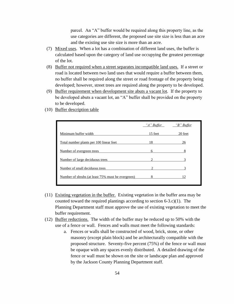
(10) Buffer description table
(11) Existing vegetation in the buffer. Existing vegetation in the buffer area may be
counted toward the required plantings according to section 6-3.c)(1). The
Planning Department staff must approve the use of existing vegetation to meet the
buffer requirement.
(12) Buffer reductions. The width of the buffer may be reduced up to 50% with the
use of a fence or wall. Fences and walls must meet the following standards:
a. Fences or walls shall be constructed of wood, brick, stone, or other
masonry (except plain block) and be architecturally compatible with the
proposed structure. Seventy-five percent (75%) of the fence or wall must
be opaque with any spaces evenly distributed. A detailed drawing of the
fence or wall must be shown on the site or landscape plan and approved
by the Jackson County Planning Department staff.
“A” Buffer “B” Buffer
Minimum buffer width 15 feet 20 feet
Total number plants per 100 linear feet 18 26
Number of evergreen trees 6 8
Number of large deciduous trees 2 3
Number of small deciduous trees 2 3
Number of shrubs (at least 75% must be evergreen) 8 12
55
b. Fences and walls shall be a minimum of 6' tall;
c. The finished side of the fence or wall shall face the abutting property; and
d. A planting strip with a minimum width of 5' shall be located between the
fence or wall and the property line. The strip shall be planted with trees
and/or shrubs on the side that faces the abutting property. The trees
and/or shrubs shall be spaced no further than 8' apart in order to screen at
least 50% of the fence or wall at maturity.
e) Screening of dumpsters, loading docks, outdoor storage areas, and utility structures. All
dumpsters, loading docks, or utility structures visible from a public street or adjacent
property line shall be screened unless already screened by an intervening building or
bufferyard. Landscaping shall not interfere with the access and operation of any such
structure or facility. All unenclosed outdoor storage areas greater than 15 square feet
shall also be screened from adjacent properties and streets. Screen types include:
(1) A continuous hedge of evergreen and/or densely twigged shrubs planted in a 5'
strip with plants spaced no more than 5' apart or a row of evergreen trees planted
no more than 8' apart.
(2) A fence or wall with a minimum height of 6' with the finished side of the fence or
wall facing the abutting property or the street.
f) Street trees. Street trees are required for all new non-residential development. Street
trees shall be required at the rate of 1 large maturing (over 35' in height at maturity) for
every 40 linear feet of property abutting a street or road or 1 small maturing tree (less
than 35' in height at maturity) for every 30 linear feet of property abutting a street or
road, if overhead utility lines are present. This does not imply that trees must be spaced
exactly 30' or 40' apart, but may be clustered together with a minimum spacing of 15'.
Trees should be spaced no more than 65' apart. Street trees shall be placed in a planting
strip on private property and not within the street or road right-of-way. No street tree can
be located farther than 20' from the edge of the right-of-way to count as a street tree. The
width of the planting strip may vary but the minimum width cannot be less than 7' and the
average width shall be at least 10'. The planting area must be covered with living
material, including ground cover and shrubs, or mulch so that no soil is exposed. No
stone mulch is permitted in the planting area.
g) Parking lot landscaping requirements.
(1) Requirements for new developments. Trees and shrubs are required in and
around parking lots with more than 6 spaces to enable the parking areas to blend
in with the natural appearance of Cullowhee, to provide attractive views from
roads and adjacent properties, to reduce stormwater runoff, and to help filter
56
exhaust from vehicles. There are 3 parking lot planting requirements that may
apply to a development depending upon its relation to other properties and public
rights-of-way.
a. Perimeter and Interior Plantings. Parking lots, loading areas, and other
vehicle use areas must be planted with 1 deciduous tree and 2 shrubs for
every 2,000 square feet of vehicular use area, which includes parking
spaces, aisles, driveways, and loading areas (including gravel surfaces).
At least 75% of the required deciduous parking lot trees must be large-
maturing trees. Trees and shrubs must be placed within 20 feet of the
vehicular use area to count as parking lot landscaping. When 4 or more
trees are required in a parking lot with interior rows, 50% of the trees and
shrubs must be planted in islands or medians located within the parking
lot. Each parking space shall be located within 45 feet of a tree. In
calculating this distance, measurements shall be taken from the trunk of
the tree to the closest point of the parking space. Planting trees in groups
is encouraged to increase the total amount of planting area for roots to
grow. Trees and shrubs shall not impede vehicular or pedestrian
visibility.
b. Planting strip. A planting strip with a minimum width of 5 feet shall be
planted between the vehicular use area and the abutting property when
any vehicular use area is located within 50 feet of an abutting property
and no buffer is required, except for driveway openings that run
perpendicular to the planting strip. This planting strip shall ensure that
parking lots are separated from one another. One large evergreen or
deciduous tree and 5 evergreen or deciduous shrubs shall be planted for
every 40 linear feet of property line that parallels the vehicular use area.
Fifty percent of these trees and shrubs may be counted toward the parking
lot trees and shrubs required in subsection a. (above) if the planting strip
is located within 20 feet of the vehicle use area. Adjacent businesses on
separate properties that share parking or driveways shall be exempt from
this requirement provided that the required planting strip would interfere
with the use of the shared parking or driveway.
c. Buffering from the street. Vehicular use areas greater than 2,500 square
feet that are located within 30 feet of a street or road must be buffered
from the street or road. This buffer is required in addition to the street
trees planted in a 10 foot planting strip as required by section 6-3.f). The
buffer must contain plants that will be at least 3 feet high at maturity and
can consist of plant material alone, or berms, fences, walls, or grade
changes combined with plant material. A vegetative buffer shall contain
57
at least 1 evergreen or deciduous shrub for every 5 feet of vehicular use
area buffer required. If a fence or wall is used, at least 1 shrub must be
planted for every 8 linear feet of fence or wall. Shrubs should be evenly
distributed on each side of the fence. Berms and grade changes must be
completely covered with vegetation. All shrubs planted can count toward
the parking lot landscaping requirement.
(2) Size of planting islands. Tree planting islands within vehicular use areas shall be
a minimum of 150 square feet and have no width less than 9 feet.
(3) Protection of trees. Planting areas and islands shall be protected by curbing,
bollards, or parking barriers if a tree or shrub is within 6 feet of the edge of the
pavement. Trees in islands should be set back at least 4 feet from the edge of the
island so as not to interfere with car doors opening.
h) Multi-family residential developments. In addition to other landscaping requirements,
multi-family residential developments, including townhome developments with more
than 20 dwellings, shall provide one large maturing deciduous tree for every three
dwelling units, planted within the required open space on the property.
i) Compliance and maintenance.
(1) Certificate of occupancy. Landscaping must be installed and inspected prior to
receiving a certificate of occupancy for the construction. Vegetation shall be
planted to ensure the best chance of survival and to reduce the potential expense
of replacing damaged plant materials. If the season or weather conditions prohibit
planting the materials, the developer may provide a bond, an irrevocable letter of
credit, or other financial surety in the amount of 150% of the cost of installing the
required landscaping to guarantee the completion of the required planting. Upon
approval of the financial surety, the certificate of occupancy shall be issued. The
financial surety shall be canceled and/or returned upon completion of the required
landscaping.
(2) Maintenance. The owner or lessee of the property on which landscaping is
required shall be responsible for the maintenance and protection of all plant and
screening material. Landscaped areas shall be maintained in good condition and
kept free of debris. Failure to maintain or to replace dead, damaged, or diseased
plant material or to replace a broken fence or wall shall constitute a violation of
this ordinance and shall be subject to the penalty provisions set forth in section
12-2 if no corrective action is taken within 30 days of receiving notice. If an act
of God or other catastrophic event occurs that destroys a large quantity of
vegetation, the owner or lessee shall have 120 days to replant. Replaced plant
material must comply with the minimum size, spacing, and quantity standards of
58
this ordinance.
j) Plant specifications
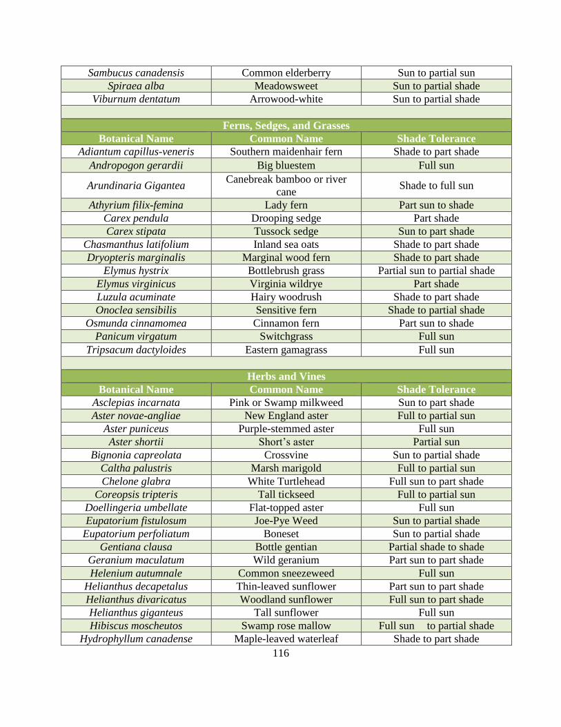
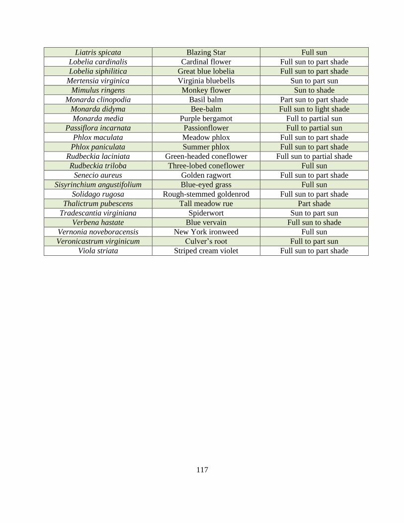
(1) Recommended plant species. (Appendix A) The use of plant materials that are
indigenous to the region and readily available from local nurseries is encouraged.
Native plant materials are acclimated to the area, are better suited for survival,
and maintain the character and appearance of the Cullowhee Community.
(2) Minimum plant size requirements:
a. Large maturing deciduous tree: Greater than 35 feet in height at maturity.
Minimum size at planting shall be 2 inches caliper with a 12 to 14 foot
height.
b. Small maturing deciduous tree: Less than 35 feet in height maturity.
Minimum size at planting shall be 1 ½ inches in caliper with an 8 to 10
foot height.
c. Evergreen tree: Minimum height at planting shall be 6 feet.
d. Deciduous shrub: Minimum size at planting shall be a 3 gallon container
or 10 inch root ball with a height of 18 inches.
e. Evergreen shrub: Minimum size at planting shall be a 3 gallon
container or 10 inch root ball with a height of 18 inches.
(3) Plant standards. All plants must meet the requirements of the most recent edition
of the American Standards for Nursery Stock, ANSI 260.1. Plants must be
healthy, well-branched, and free of disease and insect infestation.
Sec. 6-4. Parking, loading, and access standards.
a) Purpose. Off-street parking, loading, and access standards are established for the
following purposes:
(1) To ensure the uniform development of parking areas throughout the Cullowhee
community.
(2) To provide for safe and adequate space for the temporary parking of vehicles.
(3) To promote the efficient use of parking areas.
(4) To ensure the safety of vehicles entering and exiting parking areas from and to the
public road system.
b) Parking lot design. The following standards shall be met in designing off-street parking
facilities.
(1) Parking aisles shall have a minimum width of 12' for one-way traffic and 18' for
two-way traffic.
59
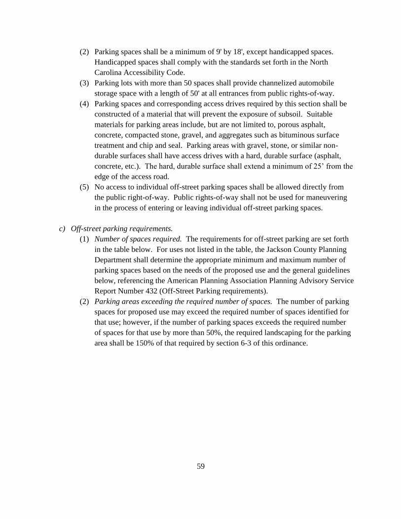
(2) Parking spaces shall be a minimum of 9' by 18', except handicapped spaces.
Handicapped spaces shall comply with the standards set forth in the North
Carolina Accessibility Code.
(3) Parking lots with more than 50 spaces shall provide channelized automobile
storage space with a length of 50' at all entrances from public rights-of-way.
(4) Parking spaces and corresponding access drives required by this section shall be
constructed of a material that will prevent the exposure of subsoil. Suitable
materials for parking areas include, but are not limited to, porous asphalt,
concrete, compacted stone, gravel, and aggregates such as bituminous surface
treatment and chip and seal. Parking areas with gravel, stone, or similar non-
durable surfaces shall have access drives with a hard, durable surface (asphalt,
concrete, etc.). The hard, durable surface shall extend a minimum of 25’ from the
edge of the access road.
(5) No access to individual off-street parking spaces shall be allowed directly from
the public right-of-way. Public rights-of-way shall not be used for maneuvering
in the process of entering or leaving individual off-street parking spaces.
c) Off-street parking requirements.
(1) Number of spaces required. The requirements for off-street parking are set forth
in the table below. For uses not listed in the table, the Jackson County Planning
Department shall determine the appropriate minimum and maximum number of
parking spaces based on the needs of the proposed use and the general guidelines
below, referencing the American Planning Association Planning Advisory Service
Report Number 432 (Off-Street Parking requirements).
(2) Parking areas exceeding the required number of spaces. The number of parking
spaces for proposed use may exceed the required number of spaces identified for
that use; however, if the number of parking spaces exceeds the required number
of spaces for that use by more than 50%, the required landscaping for the parking
area shall be 150% of that required by section 6-3 of this ordinance.
60
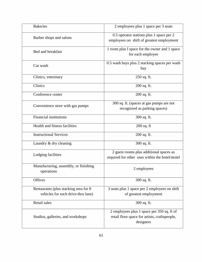
TYPE OF LAND USE ONE PARKING SPACE REQUIRED FOR
EACH
Residential:
Multi-family dwellings (including
townhomes) 1 bedroom plus 0.25 space per unit for guests
Public Facilities and Institutions:
Adult care facilities 2 employees plus 1 space per 6 adults
Amphitheaters 4 seats
Child care facilities 2 employees plus 1 space per 10 children
Churches 1 per 3 seats in sanctuary
Civic, social service and fraternal facilities 350 sq. ft.
Colleges 1 per employee plus 1 space per 3 full time
students
Community centers 350 sq.ft.
Fire/police stations 5 per bay
Libraries 350 sq.ft. plus 1 space per 2 employee
Medical centers 250 sq.ft.
Museums 350 sq.ft. plus 1 space per 2 employees
Parks half acre of park land
Post Offices 500 sq.ft. of floor area
Schools 0.5 classroom plus 1 space per 5 students in
high school
Office, Business & Industrial Uses:
Automobile service stations and auto
repair garages 1 service bay plus 1 space per 2 employees
61
Bakeries 2 employees plus 1 space per 3 seats
Barber shops and salons 0.5 operator stations plus 1 space per 2
employees on shift of greatest employment
Bed and breakfast 1 room plus I space for the owner and 1 space
for each employee
Car wash 0.5 wash bays plus 2 stacking spaces per wash
bay
Clinics, veterinary 250 sq. ft.
Clinics 200 sq. ft.
Conference center 200 sq. ft.
Convenience store with gas pumps 300 sq. ft. (spaces at gas pumps are not
recognized as parking spaces)
Financial institutions 300 sq. ft.
Health and fitness facilities 200 sq. ft
Instructional Services 200 sq. ft.
Laundry & dry cleaning 300 sq. ft.
Lodging facilities 2 guest rooms plus additional spaces as
required for other uses within the hotel/motel
Manufacturing, assembly, or finishing
operations 2 employees
Offices 300 sq. ft.
Restaurants (plus stacking area for 8
vehicles for each drive-thru lane)
3 seats plus 1 space per 2 employees on shift
of greatest employment
Retail sales 300 sq. ft.
Studios, galleries, and workshops
2 employees plus 1 space per 350 sq. ft of
retail floor space for artists, craftspeople,
designers
62
Theaters 4 seats
Self-service storage facilities 10 storage units plus 1 space per 2 employees
d) Shared and remote parking
(1) Shared parking. The Jackson County Planning Department shall approve the
joint use of up to 100% of the required parking spaces for 2 or more uses located
on the same or adjacent parcels, provided that the developer can demonstrate that
the spaces provided will meet the need for parking. This may be done by
demonstrating that an adequate number of spaces are provided for all uses or by
demonstrating that the uses will not overlap in hours of operation or in demand
for the shared spaces. Any sharing of required parking spaces by uses located on
different parcels shall be guaranteed by a written agreement between the owner of
the parking area and the owner of any use located on a different parcel and served
by the parking area.
(2) Remote parking. If the required number of parking spaces for any land use cannot
be reasonably provided on the same lot on which the principal use is located, the
parking spaces may be provided on any land within 500 feet of the property on
which the principal use is located. The zoning district regulations for the property
on which the parking is located must permit the principal use that the parking
spaces serve. Any remote parking spaces located on a different parcel than the use
served shall be guaranteed by a written agreement between the owner of the
remote parking area and the owner of the principal use.
e) Access point requirements. The following standards shall be met when designing
vehicular access points from public roads to individual non-residential properties
(1) Width of access points:
Minimum Maximum
One-way 14 ft 20 ft
Two-way 24 ft 36 ft
63
(2) Distance from street intersections. The minimum distance between access points
and street intersections shall be 50 feet.
(3) Distance from other access points. The minimum distance as measured along the
right-of-way line, or the edge of the roadway for private roads, between the edge
of adjacent access points on different properties shall be 50 feet. The minimum
distance between the edges of adjacent access points on the same property shall
be 100 feet.
(4) Distance from property line. Unless the access point is shared between two or
more adjoining properties, all access points shall be located at least 5 feet from all
property lines perpendicular to the road.
(5) Sites unable to meet distance requirements. For sites with insufficient road
frontage to meet minimum spacing requirements, consideration shall first be
given to providing access via connection to a side road, utilization of a joint or
shared driveway with an adjacent property that meets the recommended spacing
requirement, or development of a service road to serve multiple properties. If
these options are not available, the Planning Director may grant approval of an
alternate access request, taking into consideration access to the property and
safety.
(6) Street or driveway access permit. An application for a site specific Street and
Driveway Access Permit shall be submitted to the North Carolina Department of
Transportation in accordance with minimum rules and procedures set forth in the
Policy on Street and Driveway Access to North Carolina Highways. The District
Engineer for the North Carolina Department of Transportation will notify and
consult with the Jackson County Planning Department regarding access locations
or signalization requested as part of any permit application.
Sec. 6-5. Stormwater management standards.
a) Purpose. The stormwater standards set forth below are provided to protect life and
property and minimize nuisances by limiting destructive runoff and flooding generated
by impervious surface areas; and to protect water quality and natural ecosystems by
requiring the filtering of sediments and pollutants such as nitrogen, phosphorus, trace
metals, and hydrocarbons.
b) General information.
(1) Applicability. The requirements set forth in this section shall apply to new and
existing development as follows:
a. New development:
i. For new development where the impervious surface is
between 1000-5000 square feet, a stormwater management
64
system concept plan is required that follows design
guidelines given in the most recent edition of the Stormwater
Best Management Practices Manual published by the North
Carolina Department of Environment and Natural Resources.
ii. For new development where the amount of impervious
surface being created is 5000 square feet or more, the
requirements for a stormwater management plan set forth in
subsections c and d of this Section shall apply.
b. Existing Development:
i. For existing development where the amount of impervious
surface is being expanded by 25% or more of the original
amount and the total amount of impervious surface is less
than 5000 square feet, a stormwater management system
concept plan is required that follows the design guidelines
given in the most recent edition of the Stormwater Best
Management Practices Manual published by the North
Carolina Department of Environment and Natural Resources.
ii. For existing development where the impervious surface is
being expanded and the total amount is over 5000 square
feet, the requirements for a stormwater management plan set
forth in subsections c and d of this Section shall apply.
(2) Stormwater Management Measures Required
a. For projects meeting the thresholds identified in (a)(ii) and (b)(ii)above,
the property owner and/or developer shall provide a stormwater
management plan that accommodates the stormwater run-off generated
by a 10-year, 24-hour rain event or, if the property is located within a
designated Protected Watershed Area, the 25-year storm. Stormwater
measures shall be designed to remove, at a minimum, 85% of the Total
Suspended Solids (TSS) from the first inch of rainfall of any rain event.
Stormwater measures shall have a drawdown of at least 48 hours, but not
more than 120 hours.
b. Stormwater measures shall be designed by an appropriately qualified
engineer, landscape architect or other appropriately qualified
professional, and shall be constructed and maintained in accordance with
commonly accepted best practices. Innovative designs that utilize “low
impact” and non-structural control and treatment measures are
encouraged.
c. Stormwater measures may be located off-site provided such measures are
located within a parcel of land under the same ownership as the affected
65
property or within a common area under the management of a property
owners’ association or similar entity.
c) Stormwater Management Plan Requirements The stormwater management plan shall
show:
(1) The existing site topography and proposed site drainage improvements in
sufficient detail to facilitate plan review and construction. The plan drawings shall
be presented at a scale no larger than 1 inch = 50 feet.
(2) Engineering drawings showing plan, profile and details of piping, drainage
structures, swales, and channels tying into a network of pre-existing manmade or
natural channels.
(3) Written project specifications governing work performance and materials.
(4) Computations and assumptions sufficient to support the design of piping, drainage
structures, retention/detention ponds, and permanent erosion control measures.
(5) Location of proposed structural stormwater controls;
(6) Low impact design elements;
(7) Location of existing and proposed conveyance systems such as grass channels,
swales, and storm drains;
(8) Flow paths;
(9) Location of floodplain/floodway limits;
(10) Relationship of site to upstream and downstream properties and drainages;
(11) Location of proposed stream channel modifications, such as bridge or culvert
crossings;
(12) Whatever other narrative statements are necessary to adequately describe the
proposed site improvements.
(13) The stormwater management plan shall be filed with the Jackson County Planning
Department, and a copy shall be simultaneously submitted to the Jackson Soil and
Water Conservation District, at least 30 calendar days prior to the commencement
of the proposed activity.
d) Stormwater Permit Required. The Jackson County Planning Department shall review all
stormwater plans required by this Ordinance to ensure compliance therewith. In making
this determination, the County shall use the Stormwater Best Management Practices
Manual published by the North Carolina Department of Environment and Natural
Resources or other commonly accepted information and engineering data. The County
will review each complete plan submitted to them and within 30 calendar days of receipt
thereof will notify the person submitting the plan that it has been approved, approved
with modifications, approved with performance reservations, or disapproved. Incomplete
plans shall be returned for completion. The 30 day review period will not begin until all
66
required items are submitted. The Planning Department shall have five business days to
check the plans for completeness. Failure to approve, approve with modifications, or
disapprove a complete Stormwater Management System Concept Plan within 30 calendar
days of receipt shall be deemed approval. Disapproval of a plan must specifically state,
in writing, the reasons for disapproval. If, following commencement of a land-disturbing
activity pursuant to an approved plan, the County determines that the plan is inadequate
to meet the requirements of this ordinance, the County may require any revision of the
plan that is necessary to comply with this ordinance. Failure to approve, approve with
modifications, or disapprove a revised Stormwater Management System Concept Plan
within 15 calendar days of receipt shall be deemed approval of the plan. The County
shall establish an expiration date of three years for Stormwater Management System
Concept Plans approved under this ordinance. Fees as established by the Jackson County
Board of Commissioners shall be due and payable upon submission of the application. If
a person initiates land-disturbing activity which would have required a permit without
obtaining such a permit, the Planning Department is authorized to double the regular
permit fee.
e) As-Built Plans and Final Approval. For all developments subject to these standards,
upon completion of a project, and before final project approval or a certificate of
occupancy may be granted, the applicant shall certify that the completed project has been
built in accordance with the approved stormwater management plans and designs. The
applicant shall submit actual “as built” plans for all stormwater management facilities or
practices after final construction is completed. The plans shall show the final design
specifications for all stormwater management facilities and practices and the field
location, size, depth, and planted vegetation of all measures, controls, and devices, as
installed. The designer of the stormwater management measures and plans shall certify,
under seal, that the as-built stormwater measures, controls, and devices are in compliance
with the approved stormwater management plans and designs and with the requirements
of this ordinance. A final inspection and approval by the County is necessary prior to the
issuance of any certificate of occupancy, release of improvement guarantee, or other final
approval.
f) Inspection and Maintenance of Measures.
(1) All stormwater improvements must be maintained so they will continue to serve
their intended functions. If the stormwater improvements are to be turned over to
a property owners association or a property owner, the developer must maintain
stormwater improvements until accepted by a property owners association or
property owner. The developer must disclose which party will be responsible for
continued maintenance on the record plat and on the stormwater management
67
plan. The developer will be responsible for the installation, operation, and
maintenance of the stormwater controls until ownership is conveyed. The
responsibility and agreement for operation and maintenance for the stormwater
system is transferred with title, as each property is conveyed.
(2) The County shall have the right to demand an inspection report at any time should
there be reasonable belief that any stormwater structure or feature is constructed
or being maintained in violation of this ordinance. Such inspection report shall be
prepared by a registered North Carolina professional engineer, surveyor, or
landscape architect performing services only in their area of competence. The
report shall contain the following:
a. The name and address of the land owner.
b. The recorded book and page number of the lot of each stormwater
control.
c. A statement that an inspection was made of all stormwater controls and
features.
d. The date the inspection was made.
e. A statement that all inspected controls and features are performing
properly and are in compliance with the terms and conditions of the
approved maintenance agreement required by this ordinance.
f. The signature and seal of the engineer, surveyor, or landscape architect.
(3) Should the stormwater inspection reveal substantial maintenance or repair
recommendations, it shall be the owner’s responsibility to retain a registered
professional engineer or landscape architect competent in the area of stormwater
management to develop plans and specifications for such repairs within 30 days
from finding that substantial maintenance or repair recommendations are
necessary. Maintenance or repair work must commence within 60 days, and be
completed within a reasonable amount of time, from the finding that substantial
maintenance or repair recommendations are necessary. The owner of each
stormwater measure, whether structural or non-structural in design, shall maintain
it so as not to create or permit a nuisance condition.
Sec 6-6. Architectural design standards.
a) General. Building design and architecture are critical components for quality
development. Building architecture design standards are intended to promote
compatibility within a development and throughout the Cullowhee Planning Area, allow
creativity and diversity of design, protect property values and neighborhood quality, and
provide a safe and attractive environment for residents and visitors alike in the
community.
68
b) Applicability. The standards in this section shall apply to all non-residential development
and to multi-family residential development proposing 12 or more dwelling units.
c) Building Materials and Color
(1) Materials
a. All buildings shall be constructed of stone, exposed timber, fiber cement
siding, wood siding, shingle siding, brick, or other high quality masonry
material. No building shall be covered with sheet or corrugated metal or
with vinyl siding.
b. Exterior building materials shall be continued to finished grade of any
elevation in accordance with minimum manufacturer specifications.
c. Cornices shall be constructed of brick, stone, wood, pre-cast concrete, or
other high quality, long-lasting material.
d. Architectural accent materials located above the roof line shall be
constructed of brick, stone, wood, pre-cast concrete, architectural quality
steel, fiber cement siding or other high quality, long-lasting material.
(2) Colors
a. Color schemes used for buildings shall aesthetically integrate building
elements together, relate separate (free-standing) buildings on the same
lot or parcel to each other, and be used to enhance the architectural form
of the building.
b. Exterior colors for new buildings and structures, including roofs, shall
be coordinated with the predominant colors of the surrounding natural
and built environment to minimize contrast between the structure and
the surrounding area.
c. All building projections, including, but not limited to, chimneys, flues,
vents, and gutters, shall match or complement in color the permanent
color of the surface from which they project.
d) Building Massing and Configuration
(1) Buildings located on steep areas shall conform to hillside topography by stepping
or staggering the mass of the proposed structure up or down the slope.
(2) Building masses shall maintain a balance of scale and proportion using design
components that are harmonious with natural landforms and landscaping.
(3) Proposed structures shall not be sited atop peaks or silhouetted against the sky
when viewed from any designated public right-of-way.
e) Building Façade Character. Elements of articulation shall be employed on any building
visible from the public right-of-way or public street or pedestrian walkway to reduce the
apparent bulk and uniform appearance of large buildings, provide visual interest and
variety, and reinforce local architecture.
(1) Buildings Containing Non-Residential Uses
69
The following requirements apply to any building containing non-residential uses,
regardless of whether the building also contains residential uses:
a. Buildings with a façade length of more than forty feet shall incorporate
offsets to break the plane of the façade. The distance between required
offsets shall be every forty (40) feet.
b. A building façade that is less than or equal to the height of the building
shall not require an offset.
c. The depth or projection of the offset shall be at least two (2) feet.
d. The change in wall plane (i.e., offset) shall extend at least twenty percent
(20%) of the length of the façade wall.
(2) Buildings Containing Residential Uses
The following requirements apply to any building containing only residential
uses:
a. The distance between required offsets shall be twenty (20) feet, provided
that a building façade that is less than twenty-five (25) feet in length
shall not require an offset.
b. The depth or projection of the offset shall be at least two (2) feet
regardless of the length of the adjacent façade walls.
c. The change in wall plane (i.e., offset) shall extend at least twenty percent
(20%) of the length of the façade wall.
f) Minimum Wall Articulation
Any building greater than forty (40) feet in length, measured horizontally, that faces a
public right-of-way or private street or pedestrian walkway shall include at least three (3)
of the following features:
a. change in texture or masonry pattern
b. change in color
c. windows
d. dormers
e. trellises with vegetation
f. covered porch
g. balconies
h. parapet walls designed to meet the minimum requirements set forth of
Section 6-6, i) Roof Form and Articulation, of this Ordinance.
All sides of the building shall include articulation, materials, and design characteristics
consistent with those on the primary front façade in terms of quality and detail, unless the
public’s view of a rear or side building elevation from a public right-of-way or private
street or pedestrian walkway is blocked by intervening buildings, topography, a solid
screen wall at least six (6) feet high built using materials consistent with the building, or
landscaping measuring at least fifteen (15) feet in height at maturity.
70
g) Windows
(1) The first floor front elevation of all commercial buildings shall incorporate
windows that cover at least 40% of the wall plane. Windows shall be clear glass;
opaque or reflective glazing shall not be permitted.
(2) The first floor front elevation of all multi-family residential buildings shall
incorporate windows that cover at least 12% of the wall plane. Windows shall be
clear glass; opaque or reflective glazing shall not be permitted.
h) Entrance
All entranceways shall be clearly defined, highly visible, and feature no less than three
(3) of the following:
a. canopies or porticos;
b. overhangs;
c. recesses or projections;
d. arcades;
e. arches;
f. outdoor patios;
g. windows;
h. awnings;
i. architectural features that are integrated into the building structure or
design; or planters or wing walls that incorporate landscaped areas or
places for sitting.
i) Roof Form and Articulation
The roof of any building shall present a distinctive profile and add interest to larger
buildings, and complement the character of other buildings included on the same lot or
parcel.
(1) Flat Roof Buildings
The roof of any building with a flat roof shall include parapets to conceal the roof
and roof-top equipment from public view. The average height of such parapets
shall not exceed fifteen percent (15%) of the height of the supporting wall, unless
required for in Section 6-6.j), Rooftop Equipment Screening, of this Ordinance,
and such parapets shall not at any point exceed one-third (1/3) of the height of the
supporting wall.
Parapets used to conceal the roof and roof-top equipment for any building shall
not extend a constant height for more than one hundred (100) feet in length.
(2) Slope Roof Buildings
The roof of any building with a slope roof shall include at least two (2) of the
following to maintain proportional building architecture:
a. three (3) or more roof slope planes
b. overhanging eaves, extending no less than one (1) foot past the
supporting wall
71
c. sloping roofs that do not exceed the average height of the supporting
walls, with an average slope greater than or equal to one (1) foot of
vertical rise for every three (3) feet of horizontal run and less than or
equal to one (1) foot of vertical rise for every one (1) foot of horizontal
run.
(3) Additional Requirements
Consistent roof treatments, whether flat or sloping, shall be provided on all sides
of the building.
The back side of all cornices, parapets, and roofline that are visible from an
adjacent public right-of-way shall be finished with materials consistent with the
associated building.
j) Rooftop Equipment Screening
Screening Requirements
(1) All rooftop mechanical equipment and vents greater than eight (8) inches in
diameter shall be:
a. screened from the line of sight of public rights-of-way, private roads,
parking lots, public sidewalks, greenways, and internal pedestrian ways
except for instances where site topography precludes reasonable
compliance with the minimum screening requirement;
b. screened by either a parapet wall along the building edge or a
freestanding screen wall on the roof of a material, color, and design
architecturally compatible with the building, that is at least as high as the
equipment and vents for which the screening is designed to hide.
k) Franchise Architecture
To maintain the unique character of the Cullowhee Planning Area, buildings shall not be
constructed or renovated using franchise architecture. Franchise or national chains may
be permitted in the Cullowhee Planning Area, but must follow the standards of this
Ordinance to create a building that is compatible with the Cullowhee Planning Area.
l) Architectural Unity
All buildings within the same lot or parcel shall be architecturally unified. Architectural
unity means that buildings shall be related and compatible in style, color, scheme,
quality, and type of exterior building materials.
Sec 6-7. Flexible development standards.
a) Purpose. This section provides the Jackson County Planning Department with the
authority to permit deviations from the development standards for setbacks, lot width,
and number of parking spaces required by this ordinance, provided certain conditions are
met. The flexible development standards shall be administered in order to promote the
72
orderly development and redevelopment of property within the Cullowhee Community.
Decisions shall be in writing and conditions may be placed on the approval of flexible
development standards to ensure that the intent of this ordinance is achieved. Decisions
of the Planning Department may be appealed to the Cullowhee Community Planning
Council as outlined in section 9-2 of this ordinance.
b) Flexible standards permitted. The Jackson County Planning Department may approve
the following flexible development standards.
(1) Setbacks. The Planning Department is authorized to approve deviations from the
required setbacks set forth in Article IV of this ordinance by up to 10%, provided
there are site or structural conditions that preclude strict adherence to the setback
requirements or the proposed location of the structure will allow preservation of
existing vegetation.
(2) Parking. The Planning Department is authorized to approve parking lots for uses
that have up to 25% less than the required number of spaces set forth in section 6-
4, provided that the applicant provides proof that the proposed number of spaces
will meet the needs of the use; the project is a redevelopment of an existing
structure and there is insufficient space on the site to accommodate the required
parking; or the reduced parking will permit the preservation of existing
vegetation.
(3) Lot dimension. The Planning Department is authorized to approve deviations of
up to 10% in the required lot widths set forth in Article IV, provided the reduced
lot width will not inhibit the reasonable use of the lot.
ARTICLE VII. SIGN REGULATIONS
Sec. 7-1. Purpose and scope.
a) Purpose. The purpose of this article is to provide sign standards and regulations that
permit the adequate identification of activities and businesses while at the same time
promoting signs that do not unduly detract from the aesthetics and natural appeal of the
Cullowhee Planning Area; that reduce intrusions and protect property values; that provide
for improved public safety while minimizing undue distraction of the motoring public;
that provide standards for the erection and maintenance of signs; that provide for the
protection and enhancement of the tourist industry by promoting a more harmonious and
pleasing community image; and that generally enhance and strengthen the long term
economic viability of the Cullowhee Planning Area.
b) Scope. The provisions of this article shall apply to the erection and maintenance of all
signs and sign structures within the Cullowhee Planning Area, and it shall be unlawful
73
following the effective date of this ordinance to erect, maintain, or alter any sign or sign
structure except in conformance with the provisions of this article.
Sec. 7-2. General provisions.
a) Permit requirement. Except as otherwise provided in sections 7-2.b) and 7-2.c), it shall
be unlawful to erect or maintain any sign or sign structure without first obtaining a sign
permit. Application for the permit shall be made in writing on forms provided by the
Jackson County Planning Department. The procedure for applying for a sign permit is
found in section 8-6 of this ordinance. Failure to obtain a sign permit shall constitute a
violation of this ordinance.
b) Signs exempt from regulation. Unless otherwise prohibited in this or other applicable
regulations, the following signs are exempt from regulation under this ordinance:
(1) Signs that are not designed to be visible beyond the boundaries of the property
upon which they are located and/or from any public thoroughfare or right-of-way,
except as such signs may be permitted hereafter.
(2) Official governmental notices and notices posted by governmental officers in the
performance of their duties; governmental signs and signs posted under
governmental authority that note the donation of buildings, structures, or
streetscape materials (such as, but not limited to, benches, trash cans, lampposts,
and park facilities).
(3) Flags of the United States, the State of North Carolina, Jackson County, any
religious, fraternal, or civic organization, or any educational or cultural facility
and/or any one corporate flag per lot provided that they do not exceed 5’x 8’ or 40
square feet in area, that they are displayed on flagpoles not exceeding 25 feet in
height, that no more than one flagpole is located on a lot of less than one acre and
that all flagpoles are setback at least the height of the flagpole from all property
lines. Flagpoles may be roof or wall-mounted provided the size, height, and
setback requirements as established in this exemption are met.
(4) Decorative and incidental flags identifying that the business establishment is open
or serving as a decorative feature provided that the area of any single flag does
not exceed twelve (12) square feet not to exceed 2 flags per lot.
(5) Temporary decorations or displays, when such are clearly incidental to and are
customarily and commonly associated with any national, local, or religious
holiday/celebration.
(6) Temporary or permanent signs erected by public utility companies or construction
companies to warn of danger or hazardous conditions, including signs indicating
the presence of underground cables and gas lines, and similar devices and signs
providing direction around such conditions.
74
(7) Merchandise, pictures, or models of products or services that are incorporated as
an integral part of a window display.
(8) Signs displayed on trucks, buses, trailers, or other vehicles that are being operated
in the normal course of a business, such as signs indicating the name of the owner
or business and that are affixed or painted onto moving vans, delivery trucks,
contractor’s vehicles and equipment and the like, are exempt from regulation
provided that, when not being operated, the vehicles are parked or stored in areas
appropriate for their use as vehicles and in such a manner and location on the lot
so as to minimize their visibility from any street to the greatest extent possible.
All such vehicles must have current and valid registration and inspection.
(9) Trademarks or product names that are displayed as part of vending machines,
dispensing machines, and gasoline pumps.
(10) Signs required for or specifically authorized for a public purpose by any law,
statute, or ordinance. These signs may be of any type, number, and area, height
above grade, location, or illumination authorized by law, statute, or ordinance
under which such signs are required or authorized.
(11) Signs that display information pertinent to the safety or legal responsibilities of
the general public with regard to a particular property and that are located on the
property to which the information pertains. No advertising may be affixed to such
a sign.
(12) Temporary signs/banners providing directions or other information in conjunction
with a community festival or civic event subject to the following: Banners are
limited to 60 square feet; may not contain commercial advertisement; and may not
be placed within the DOT Right of Way; banners are permitted 14 days prior to
the event and must be removed within 24 hours of the close of the event.
(13) Signs affixed to the windows of vehicles displaying the terms of sale of the
vehicle.
(14) Yard/garage sale signs for one/two day residential use provided they are put in
place no sooner than 48 hours prior to the event and removed immediately
following the close of the event.
(15) Signs posted on private property related to trespassing or public safety, such as
danger from animals. However, said signs shall not exceed 3 square feet in size
and not more than 2 signs shall be placed on any parcel of land.
(16) Private commercial signs indicating charge card information or general
instructions, restrictions, etc. thereof.
(17) Signs displayed in commercial zones that are sponsored by municipal, school,
civic, and other non-profit organizations.
75
c) Signs exempt from permit requirements. The following signs are permitted in any
location and do not require a sign permit. However, the signs must conform to the
requirements set forth below as well as to other applicable requirements of this
ordinance.
(1) Real estate signs. Temporary signs advertising the sale, rental, or lease of the
property on which the sign is located, provided the signs are not illuminated and
do not exceed 2 signs per lot, do not exceed 4 feet in height, and do not exceed 4
square feet per face for residential property, or do not exceed 8 feet in height and
32 square feet per face for commercial property. All such signs shall be removed
within 7 days after the closing of the sale, rental, or lease of the property.
(2) Commemorative signs. Commemorative signs that do not exceed 8 square feet per