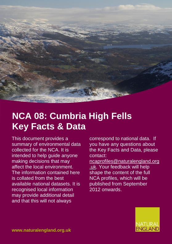
This document provides a summary of environmental data collected for the NCA. It is intended to help guide anyone making decisions that may affect the local environment. The information contained here is collated from the best available national datasets. It is recognised local information may provide additional detail and that this will not always correspond to national data. If you have any questions about the Key Facts and Data, please contact: [email protected].uk . Your feedback will help shape the content of the full NCA profiles, which will be published from September 2012 onwards. NCA 08: Cumbria High Fells Key Facts & Data www.naturalengland.org.uk
Transcript
This document provides a summary of environmental data collected for the NCA. It is intended to help guide anyone making decisions that may affect the local environment. The information contained here is collated from the best available national datasets. It is recognised local information may provide additional detail and that this will not always
correspond to national data. If you have any questions about the Key Facts and Data, please contact: [email protected]. Your feedback will help shape the content of the full NCA profiles, which will be published from September 2012 onwards.
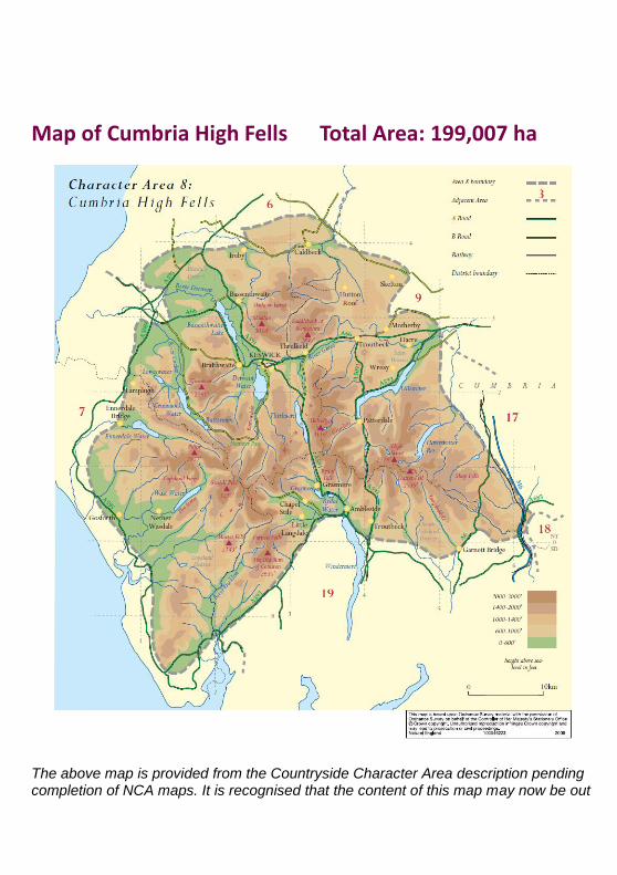
The above map is provided from the Countryside Character Area description pending completion of NCA maps. It is recognised that the content of this map may now be out
of date in some cases and is included for general reference only. New maps will include updated content and be provided within the full NCA profiles, due to be completed by 2013.
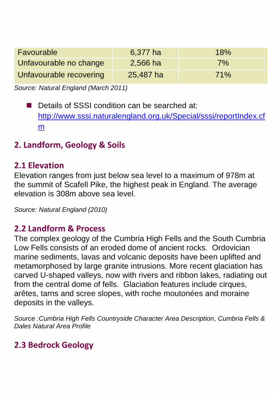
1. Landscape and Nature Conservation Designations Approximately 88% of the NCA (175,564 ha) is within the Lake District National Park. Management Plans for the Protected Landscape(s) can be found at: http://www.lakedistrict.gov.uk/
Please note: Part of this NCA is affected by an Order extending the Lake District National Park. This will not take effect unless confirmed by the Secretary of State. Please see www.naturalengland.org.uk/lakestodales for current status. Source: Natural England (2011)
1.1 Designated nature conservation sites The NCA includes the following statutory nature conservation designations:
Tier Designation Designated Site(s)
Area in NCA
Proportion of NCA
International Ramsar Duddon Estuary
4 ha <1%
European Special Protection Area (SPA)
Duddon Estuary SPA
4 ha <1%
Special Area of Conservation (SAC)
Lake District High Fells SAC; River Derwent & Bassenthwaite
Lake SAC; River Eden SAC; Borrowdale Woodland Complex SAC; Naddle Forest SAC; Wast Water SAC, Ullswater Oakwoods SAC; North Pennine Dales Meadows SAC; Asby Complex River Kent SAC; Tarn Moss SAC; Clints Quarry SAC; River Ehen SAC; Drigg Coast SAC; Morecambe Bay SAC
National National Nature Reserve (NNR)
Bassenthwaite Lake NNR, Tarn Moss NNR, Sandybeck Meadow NNR
576 ha <1%
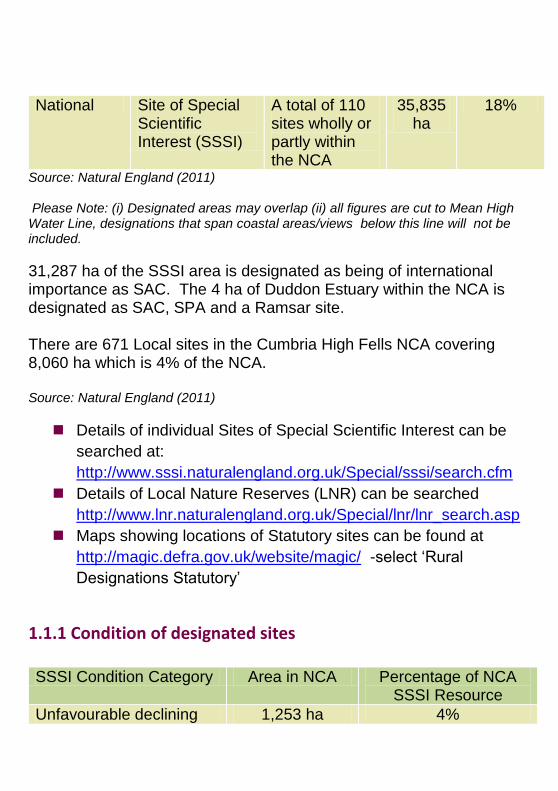
National Site of Special Scientific Interest (SSSI)
A total of 110 sites wholly or partly within the NCA
35,835 ha
18%
Source: Natural England (2011) Please Note: (i) Designated areas may overlap (ii) all figures are cut to Mean High Water Line, designations that span coastal areas/views below this line will not be included.
31,287 ha of the SSSI area is designated as being of international importance as SAC. The 4 ha of Duddon Estuary within the NCA is designated as SAC, SPA and a Ramsar site. There are 671 Local sites in the Cumbria High Fells NCA covering 8,060 ha which is 4% of the NCA. Source: Natural England (2011)
Details of individual Sites of Special Scientific Interest can be
2.1 Elevation Elevation ranges from just below sea level to a maximum of 978m at the summit of Scafell Pike, the highest peak in England. The average elevation is 308m above sea level. Source: Natural England (2010)
2.2 Landform & Process The complex geology of the Cumbria High Fells and the South Cumbria Low Fells consists of an eroded dome of ancient rocks. Ordovician marine sediments, lavas and volcanic deposits have been uplifted and metamorphosed by large granite intrusions. More recent glaciation has carved U-shaped valleys, now with rivers and ribbon lakes, radiating out from the central dome of fells. Glaciation features include cirques, arêtes, tarns and scree slopes, with roche moutonées and moraine deposits in the valleys. Source :Cumbria High Fells Countryside Character Area Description, Cumbria Fells & Dales Natural Area Profile
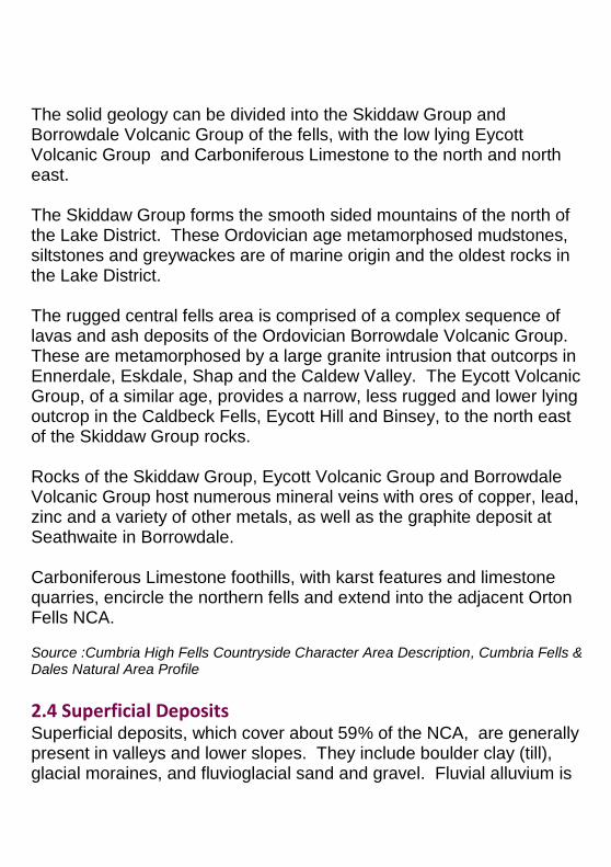
The solid geology can be divided into the Skiddaw Group and Borrowdale Volcanic Group of the fells, with the low lying Eycott Volcanic Group and Carboniferous Limestone to the north and north east. The Skiddaw Group forms the smooth sided mountains of the north of the Lake District. These Ordovician age metamorphosed mudstones, siltstones and greywackes are of marine origin and the oldest rocks in the Lake District. The rugged central fells area is comprised of a complex sequence of lavas and ash deposits of the Ordovician Borrowdale Volcanic Group. These are metamorphosed by a large granite intrusion that outcorps in Ennerdale, Eskdale, Shap and the Caldew Valley. The Eycott Volcanic Group, of a similar age, provides a narrow, less rugged and lower lying outcrop in the Caldbeck Fells, Eycott Hill and Binsey, to the north east of the Skiddaw Group rocks. Rocks of the Skiddaw Group, Eycott Volcanic Group and Borrowdale Volcanic Group host numerous mineral veins with ores of copper, lead, zinc and a variety of other metals, as well as the graphite deposit at Seathwaite in Borrowdale. Carboniferous Limestone foothills, with karst features and limestone quarries, encircle the northern fells and extend into the adjacent Orton Fells NCA. Source :Cumbria High Fells Countryside Character Area Description, Cumbria Fells & Dales Natural Area Profile
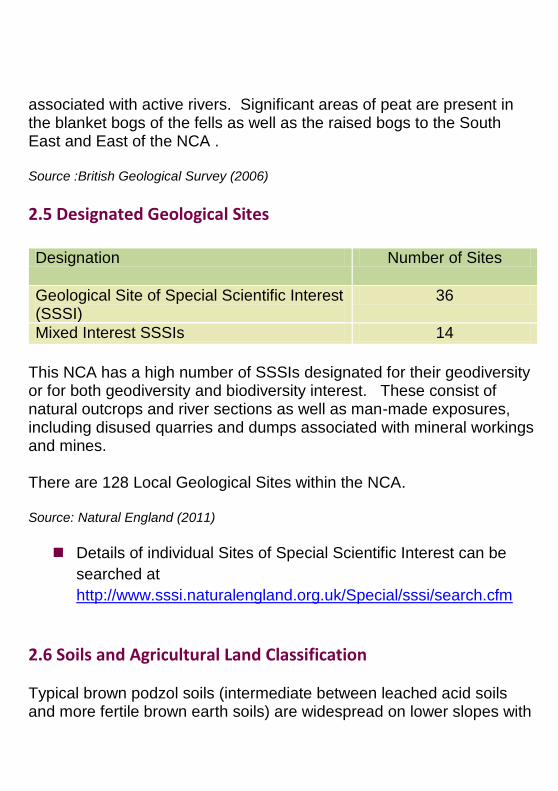
2.4 Superficial Deposits Superficial deposits, which cover about 59% of the NCA, are generally present in valleys and lower slopes. They include boulder clay (till), glacial moraines, and fluvioglacial sand and gravel. Fluvial alluvium is
associated with active rivers. Significant areas of peat are present in the blanket bogs of the fells as well as the raised bogs to the South East and East of the NCA . Source :British Geological Survey (2006)
2.5 Designated Geological Sites Designation Number of Sites
Geological Site of Special Scientific Interest (SSSI)
36
Mixed Interest SSSIs 14
This NCA has a high number of SSSIs designated for their geodiversity or for both geodiversity and biodiversity interest. These consist of natural outcrops and river sections as well as man-made exposures, including disused quarries and dumps associated with mineral workings and mines. There are 128 Local Geological Sites within the NCA. Source: Natural England (2011)
Details of individual Sites of Special Scientific Interest can be
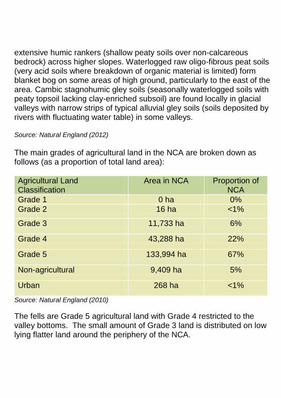
2.6 Soils and Agricultural Land Classification Typical brown podzol soils (intermediate between leached acid soils and more fertile brown earth soils) are widespread on lower slopes with
extensive humic rankers (shallow peaty soils over non-calcareous bedrock) across higher slopes. Waterlogged raw oligo-fibrous peat soils (very acid soils where breakdown of organic material is limited) form blanket bog on some areas of high ground, particularly to the east of the area. Cambic stagnohumic gley soils (seasonally waterlogged soils with peaty topsoil lacking clay-enriched subsoil) are found locally in glacial valleys with narrow strips of typical alluvial gley soils (soils deposited by rivers with fluctuating water table) in some valleys. Source: Natural England (2012)
The main grades of agricultural land in the NCA are broken down as follows (as a proportion of total land area):
Agricultural Land Classification
Area in NCA Proportion of NCA
Grade 1 0 ha 0%
Grade 2 16 ha <1%
Grade 3 11,733 ha 6%
Grade 4 43,288 ha 22%
Grade 5 133,994 ha 67%
Non-agricultural 9,409 ha 5%
Urban 268 ha <1%
Source: Natural England (2010)
The fells are Grade 5 agricultural land with Grade 4 restricted to the valley bottoms. The small amount of Grade 3 land is distributed on low lying flatter land around the periphery of the NCA.
3. Key Water Bodies & Catchments
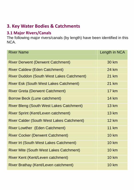
3.1 Major Rivers/Canals The following major rivers/canals (by length) have been identified in this NCA.
River Name Length in NCA
River Derwent (Derwent Catchment) 30 km
River Caldew (Eden Catchment) 24 km
River Duddon (South West Lakes Catchment) 21 km
River Esk (South West Lakes Catchment) 21 km
River Greta (Derwent Catchment) 17 km
Borrow Beck (Lune catchment) 14 km
River Bleng (South West Lakes Catchment) 13 km
River Sprint (Kent/Leven catchment) 13 km
River Calder (South West Lakes Catchment) 12 km
River Lowther (Eden Catchment) 11 km
River Cocker (Derwent Catchment) 10 km
River Irt (South West Lakes Catchment) 10 km
River Mite (South West Lakes Catchment) 10 km
River Kent (Kent/Leven catchment) 10 km
River Brathay (Kent/Leven catchment) 10 km
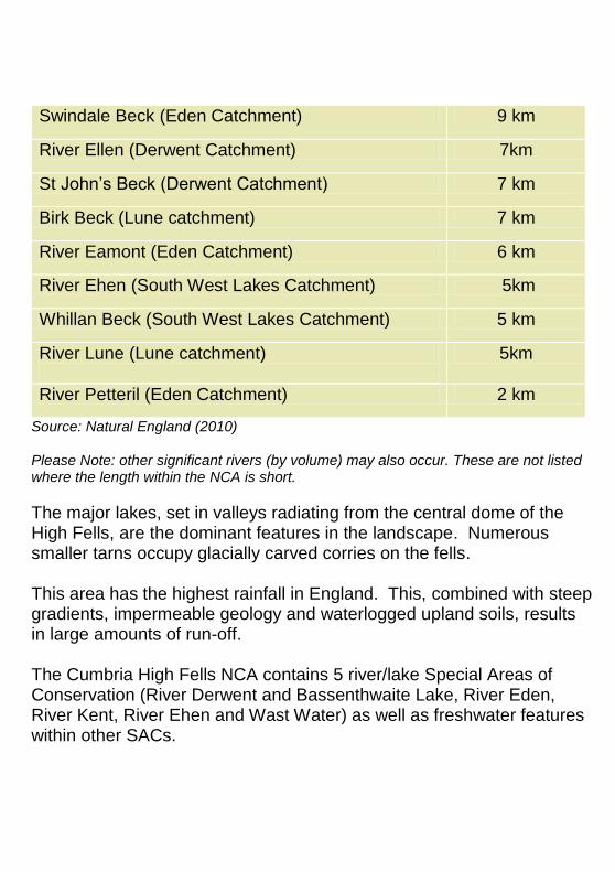
Swindale Beck (Eden Catchment) 9 km
River Ellen (Derwent Catchment) 7km
St John‟s Beck (Derwent Catchment) 7 km
Birk Beck (Lune catchment) 7 km
River Eamont (Eden Catchment) 6 km
River Ehen (South West Lakes Catchment) 5km
Whillan Beck (South West Lakes Catchment) 5 km
River Lune (Lune catchment)
5km
River Petteril (Eden Catchment) 2 km
Source: Natural England (2010) Please Note: other significant rivers (by volume) may also occur. These are not listed where the length within the NCA is short.
The major lakes, set in valleys radiating from the central dome of the High Fells, are the dominant features in the landscape. Numerous smaller tarns occupy glacially carved corries on the fells. This area has the highest rainfall in England. This, combined with steep gradients, impermeable geology and waterlogged upland soils, results in large amounts of run-off. The Cumbria High Fells NCA contains 5 river/lake Special Areas of Conservation (River Derwent and Bassenthwaite Lake, River Eden, River Kent, River Ehen and Wast Water) as well as freshwater features within other SACs.
The Eden catchment includes the Ullswater lake and Haweswater reservoir. The upper catchment is dominated by the steep gradients of Skiddaw, Helvellyn and drains north to the Irish Sea via the Solway Estuary. The River Derwent and its major tributaries rise in the high fells, draining into the Irish Sea at Workington: The Derwent Catchment includes Buttermere, Crummock Water, Loweswater, Derwent Water and Bassenthwaite Lake, as well as Thirlmere reservoir. South West Lakes catchment includes Ennerdale Water and Wast Water. From Workington to Barrow-in-Furness this catchment contains a number of small, rural „flashy‟ sub-catchments which drain in a south westerly direction to the Irish Sea. Kent/Leven catchment includes Elterwater, Rydal Water and Grasmere. The Rivers Kent, Leven and Crake drain the southern fells of the Lake District, and drain south into Morecambe Bay via the Kent and Leven estuaries. The River Lune drains only a small part of the south east of the NCA area.
3.2 Water Quality The total area of Nitrate Vulnerable Zone is 3,460 ha, 4% of the NCA. Source: Natural England (2010)
3.3 Protected Areas to be completed in consultation with the Environment Agency
(full document only).
3.4 Water Framework Directive
to be completed in consultation with the Environment Agency
(full document only).
4. Trees and Woodlands
4.1 Total Woodland Cover The NCA contains 16,607 ha of woodlands (over 2 ha), 8% of the total NCA area, of which 5,313 ha is ancient woodland. 45% of ancient woodland sites have had the semi-natural woodland replaced by plantations: Planted Ancient Woodland Sites (PAWS). About half of the woodland is commercial coniferous plantation particularly in north-western valleys and the limestone foothills to the north. Source: Natural England (2010)
4.2 Distribution and size of woodland and trees in the landscape Woodland is found mainly on lower slopes and valley bottoms, with the higher fells relatively treeless. Remnant tree cover on the fells is found in a few isolated woodlands and gills, with scattered trees and juniper scrub replaced by dwarf willow at higher altitudes. Trees are found in discrete woodlands, plantations, groups and as scattered individuals, including pollards. Areas of wood pasture (grazed open woodland) include parkland, particularly around some of the lakes. Broadleaved woodlands are found particularly in Borrowdale, around Derwent Water, Ullswater and Haweswater and in the central Lake District around Ambleside and Grasmere and in the Duddon and Longsleddale valleys. Internationally important areas of juniper scrub are associated with the central Lake District, extending into the South Cumbria Low Fells NCA. Source:Cumbria High Fells Countryside Character Area Description, Cumbria Fells & Dales Natural Area Profile, Natural England (2012)
4.3 Woodland Types
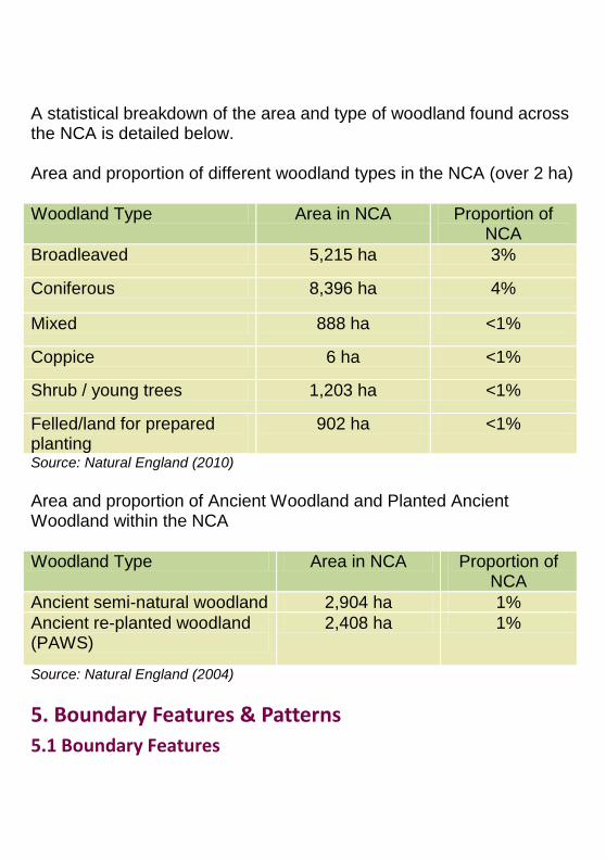
A statistical breakdown of the area and type of woodland found across the NCA is detailed below. Area and proportion of different woodland types in the NCA (over 2 ha)
Woodland Type Area in NCA Proportion of NCA
Broadleaved 5,215 ha 3%
Coniferous 8,396 ha 4%
Mixed 888 ha <1%
Coppice 6 ha <1%
Shrub / young trees 1,203 ha <1%
Felled/land for prepared planting
902 ha <1%
Source: Natural England (2010)
Area and proportion of Ancient Woodland and Planted Ancient Woodland within the NCA
Woodland Type Area in NCA Proportion of NCA
Ancient semi-natural woodland 2,904 ha 1%
Ancient re-planted woodland (PAWS)
2,408 ha 1%
Source: Natural England (2004)
5. Boundary Features & Patterns
5.1 Boundary Features
In the valleys, dry stone walls enclosing the fields and the farmsteads, create a unifying element in the landscape, and can often be seen as strongly marked patterns on valley sides. Hedges and individual trees, including pollards, are also part of the network of boundary features, and can provide connectivity between stands of woodland. Source:Cumbria High Fells Countryside Character Area description; Countryside Quality Counts (2003)
5.2 Field Patterns Patterns of rectilinear fields enclosed by dry stone walls.Small fields in the valley bottoms link through larger intakes and allotments to the open common land of the fells. Field patterns have developed and persisted since the early medieval period with a system of tenure of individually farmed in-bye fields in the valleys and extensive open common grazing on the fells. Above the fell wall the unenclosed rough grazing of the fells comprises the largest area of common land in England. The smaller inbye fields are predominantly agriculturally improved. The transition up the valley sides is marked by an increase in field size and decrease of agricultural improvement to the unimproved open fells. Source: Cumbria High Fells Countryside Character Area description; Countryside Quality Counts (2003)
6. Agriculture The following data has been taken from the Agricultural Census linked to this NCA.
6.1 Farm Type
63% of the holdings run grazing livestock. There is a long tradition of extensive hill sheep farming with common land grazing on the fells. In the lowland valleys and fringes there are some suckler herds, store cattle and dairying (the latter comprise 9% of holdings). Most of the land
(95%) has Less Favoured Area status and only a very few areas are used for arable cropping. Source: Agricultural Census, DEFRA (2010)
6.2 Farm Size The majority (79% of the total) of the agricultural land in the NCA is in large holdings over 100 ha. Between 2000 and 2009 the number of larger holdings has increased slightly while the number of smaller farms, in particular those under 50 ha, has reduced. In some cases farms may have been amalgamated and farmhouses sold separately. Source: Agricultural Census, DEFRA (2010)
6.3 Farm Ownership 47% of farms are tenanted, similar to the proportion in 2000. 2009: Total farm area = 111, 771 ha; owned land = 57, 029 ha 2000: Total farm area = 107,798 ha; owned land = 57.561 ha These figures do not include common land grazing on the fells which is an integral part of the farming system. Source: Agricultural Census, DEFRA (2010)
6.4 Land Use Just over half of the Lake District National Park was registered as agricultural land in 2002. Over half (51%) of the agricultural land within the NCA was in an agri-environment scheme in 2010. In addition to the common grazing on the fells, 96% of the remaining farmland is grassland and uncropped land (including sole rights rough grazing) for sheep, beef and a small amount of dairy. Source: Agricultural Census, DEFRA (2010)
6.5 Livestock Numbers
Numbers of livestock remain relatively high, although they have decreased since 2000. In 2009 there were 57,900 cattle (68,400 in 2000) and 597,600 sheep (795,000 in 2000). However, the number of pigs has increased significantly to 7,600 from 2,300 in 2000. Cattle represent just under 10% of livestock in the area. Source: Agricultural Census, DEFRA (2010)
6.6 Farm Labour The majority of farm employment is as the “principal” farmer (1460 in 2009) with fewer farm managers (22), full-time (168), part-time (156) or casual workers (148). Farmers continue to work in other industries to provide supplementary sources of income. Between 2000 and 2009 the number of people working in agriculture has declined by 12%. Source: Agricultural Census, DEFRA (2010) Please Note: (i) Some of the Census data is estimated by Defra so will not be accurate for every holding (ii) Data refers to Commercial Holdings only (iii) Data includes land outside of the NCA belonging to holdings whose centre point is within the NCA listed.
7. Key Habitats and Species
7.1 Habitat distribution / coverage
Fells: Fells with extensive internationally important semi-natural habitats, with good potential for ecological connectivity. Fell habitat mosaic of mainly upland heath, blanket bog and acid grassland with valley and basin mires, flushes and springs interspersed with bracken beds, scattered trees and a few small isolated woodlands.
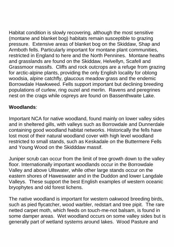
Habitat condition is slowly recovering, although the most sensitive (montane and blanket bog) habitats remain susceptible to grazing pressure. Extensive areas of blanket bog on the Skiddaw, Shap and Armboth fells. Particularly important for montane plant communities, restricted in England to here and the North Pennines. Montane heaths and grasslands are found on the Skiddaw, Helvellyn, Scafell and Grassmoor massifs. Cliffs and rock outcrops are a refuge from grazing for arctic-alpine plants, providing the only English locality for oblong woodsia, alpine catchfly, glaucous meadow grass and the endemic Borrowdale Hawkweed. Fells support important but declining breeding populations of curlew, ring ouzel and merlin. Ravens and peregrines nest on the crags while ospreys are found on Bassenthwaite Lake. Woodlands: Important NCA for native woodland, found mainly on lower valley sides and in sheltered gills, with valleys such as Borrowdale and Dunnerdale containing good woodland habitat networks. Historically the fells have lost most of their natural woodland cover with high level woodland restricted to small stands, such as Keskadale on the Buttermere Fells and Young Wood on the Skidddaw massif. Juniper scrub can occur from the limit of tree growth down to the valley floor. Internationally important woodlands occur in the Borrowdale Valley and above Ullswater, while other large stands occur on the eastern shores of Haweswater and in the Duddon and lower Langdale Valleys. These support the best English examples of western oceanic bryophytes and old forest lichens. The native woodland is important for western oakwood breeding birds, such as pied flycatcher, wood warbler, redstart and tree pipit. The rare netted carpet moth, which feeds on touch-me-not balsam, is found in some damper areas. Wet woodland occurs on some valley sides but is generally part of wetland systems around lakes. Wood Pasture and
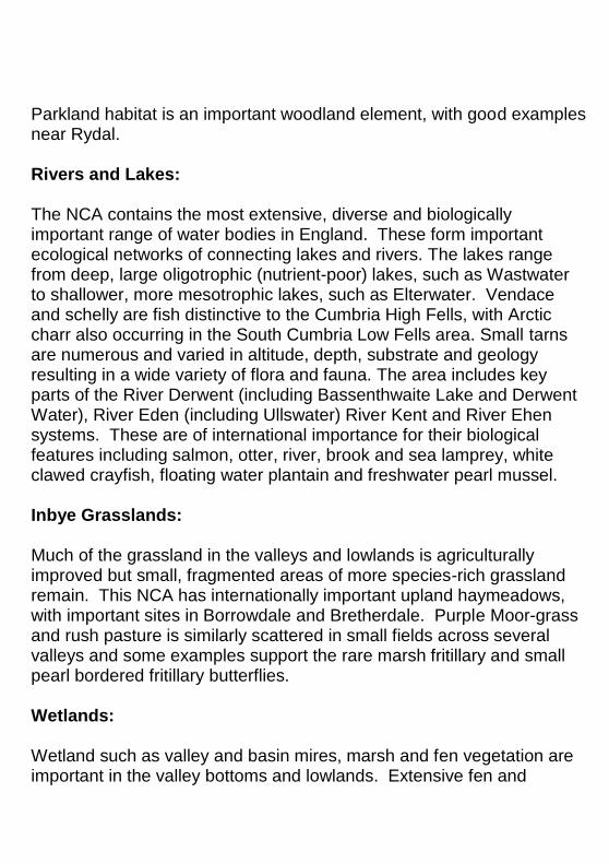
Parkland habitat is an important woodland element, with good examples near Rydal. Rivers and Lakes: The NCA contains the most extensive, diverse and biologically important range of water bodies in England. These form important ecological networks of connecting lakes and rivers. The lakes range from deep, large oligotrophic (nutrient-poor) lakes, such as Wastwater to shallower, more mesotrophic lakes, such as Elterwater. Vendace and schelly are fish distinctive to the Cumbria High Fells, with Arctic charr also occurring in the South Cumbria Low Fells area. Small tarns are numerous and varied in altitude, depth, substrate and geology resulting in a wide variety of flora and fauna. The area includes key parts of the River Derwent (including Bassenthwaite Lake and Derwent Water), River Eden (including Ullswater) River Kent and River Ehen systems. These are of international importance for their biological features including salmon, otter, river, brook and sea lamprey, white clawed crayfish, floating water plantain and freshwater pearl mussel. Inbye Grasslands: Much of the grassland in the valleys and lowlands is agriculturally improved but small, fragmented areas of more species-rich grassland remain. This NCA has internationally important upland haymeadows, with important sites in Borrowdale and Bretherdale. Purple Moor-grass and rush pasture is similarly scattered in small fields across several valleys and some examples support the rare marsh fritillary and small pearl bordered fritillary butterflies. Wetlands: Wetland such as valley and basin mires, marsh and fen vegetation are important in the valley bottoms and lowlands. Extensive fen and
swamp vegetation (as well as wet woodland) are found around many lakes and larger tarns, with good examples at the south end of Bassenthwaite Lake, Esthwaite Water and Elterwater. The area supports internationally important valley mire at Tarn Moss and nationally important lowland raised mire at Mungrisdale. Source: Cumbria Fells & Dales Natural Area Profile
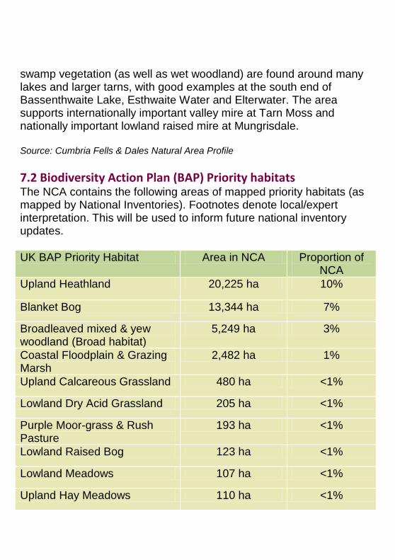
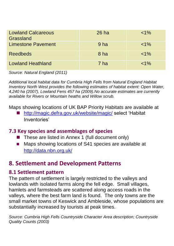
7.2 Biodiversity Action Plan (BAP) Priority habitats The NCA contains the following areas of mapped priority habitats (as mapped by National Inventories). Footnotes denote local/expert interpretation. This will be used to inform future national inventory updates.
UK BAP Priority Habitat Area in NCA Proportion of NCA
Upland Heathland 20,225 ha 10%
Blanket Bog 13,344 ha 7%
Broadleaved mixed & yew woodland (Broad habitat)
5,249 ha 3%
Coastal Floodplain & Grazing Marsh
2,482 ha 1%
Upland Calcareous Grassland 480 ha <1%
Lowland Dry Acid Grassland 205 ha <1%
Purple Moor-grass & Rush Pasture
193 ha <1%
Lowland Raised Bog 123 ha <1%
Lowland Meadows 107 ha <1%
Upland Hay Meadows 110 ha <1%
Lowland Calcareous Grassland
26 ha <1%
Limestone Pavement 9 ha <1%
Reedbeds 8 ha <1%
Lowland Heathland 7 ha <1%
Source: Natural England (2011) Additional local habitat data for Cumbria High Fells from Natural England Habitat Inventory North West provides the following estimates of habitat extent: Open Water, 4,240 ha (2007), Lowland Fens 457 ha (2009).No accurate estimates are currently available for Rivers or Mountain heaths and Willow scrub.
Maps showing locations of UK BAP Priority Habitats are available at http://magic.defra.gov.uk/website/magic/ select „Habitat
Inventories‟
7.3 Key species and assemblages of species These are listed in Annex 1 (full document only)
Maps showing locations of S41 species are available at
http://data.nbn.org.uk/
8. Settlement and Development Patterns
8.1 Settlement pattern The pattern of settlement is largely restricted to the valleys and lowlands with isolated farms along the fell edge. Small villages, hamlets and farmsteads are scattered along access roads in the valleys, where the best farm land is found. The only towns are the small market towns of Keswick and Ambleside, whose populations are substantially increased by tourists at peak times. Source: Cumbria High Fells Countryside Character Area description; Countryside Quality Counts (2003)
8.2 Main Settlements The main settlements in the Cumbria High fells are: Keswick and Ambleside. The total estimated population for this NCA (derived from ONS 2001 census data) is: 27,881. Source: Cumbria High Fells Countryside Character Area description; Countryside Quality Counts (2003), Natural England (2012)
8.3 Local vernacular & building materials Substantial farmsteads and older terraced cottages are typically constructed in stone with slated roofs. Local rocks, including different types of slate, have been used for farm buildings and walls, with sandstone, granite or limestone used for detail and finishes such as lime wash. Dry-stone walls and in places hedgerows form a visual and historic link between settlement and the countryside. Local building practices are seen in chimneys, windows and walling, as well as in hogg houses, peat houses, packhorse bridges and bank barns. Other than stone-built churches and chapels, few buildings from before the 17th century remain. The main town of Keswick has medieval origins but consists mainly of Victorian two and three storey slate buildings, built in response to the sudden influx of tourists at that time. The Lake District also contains some fine examples of villa architecture as well as wood or stone boathouses around some lakes. Source: Cumbria High Fells Countryside Character Area description; Countryside Quality Counts (2003)
9. Key Historic Sites & Features
9.1 Origin of historic features Neolithic stone circles such as Castlerigg and Swinside are the earliest built monuments in the area. Neolithic stone axe production, from
volcanic tuff in the Central Lake District, produced highly polished stone axes widely traded to southern England, Scotland and Ireland. Bronze age clearance cairns and settlement remains, are evidence of the more extensive establishment of farming on the lower slopes. Bronze Age stone circles include those at Burnmoor in Eskdale. Romano-British period sites include major forts at Troutbeck, Ambleside, Hardknott and Ravenglass, civilian settlements at Ambleside and Ravenglass, major roads, such as High Street, plus enclosures and field systems in the lower fells and valleys. Medieval and later field boundaries are based on a persisting farming system of in-bye grazing in the valleys and extensive open common grazing on the fells. Fellside “intakes” date from the 16th to 18th century. Widespread Norse place names such as “Thwaite” (clearing) as well as hog back tombstones and crosses (e.g. at Gosforth) date from the late 10th Century onwards. Industrial remains dating from the Medieval period onwards include mines, quarries, spoil tips (e.g. Coniston Copper Mines valley), smelting sites (bloomeries), charcoal pits and water-powered forges and mills. Iron manufacture was supported by charcoal production from coppiced woodlands, with a post medieval increase in woodland cover for this industry and fuel. In comparison with other NCAs in the North West there is an unusually small amount of industrial landscape. 18th century Picturesque movement features include villas, ornamental plantings and designed landscapes and views. Features associated with the influential Romantic Movement poets include houses (e.g. the Wordworths‟ Dove cottage), burial places and landscapes which inspired ideas and poetry.
National Trust properties are a specific legacy of the birth of the conservation and environmental movement in the Lake District, in response to the construction of Thirlmere reservoir in the mid 1870‟s. The relatively large number of Scheduled Monuments, particularly on the unenclosed land, is due to the lack of intensive land-use in these areas over time. Source: Draft Historic Profile, Countryside Quality Counts, Countryside Character Area description
9.2 Designated Historic Assets This NCA has the following historic designations: 4 Registered Parks and Gardens covering 230 ha
0 Registered Battlefield/s covering 0 ha
298 Scheduled Monuments
1,251 Listed Buildings
Source: Natural England (2010)
More information is available at the following address:
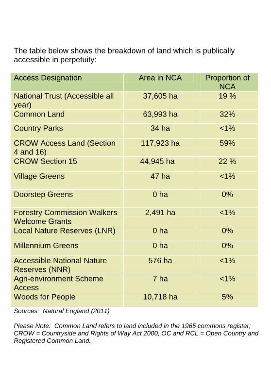
The table below shows the breakdown of land which is publically accessible in perpetuity:
Access Designation Area in NCA Proportion of NCA
National Trust (Accessible all year)
37,605 ha 19 %
Common Land 63,993 ha 32%
Country Parks 34 ha <1%
CROW Access Land (Section 4 and 16)
117,923 ha 59%
CROW Section 15 44,945 ha 22 %
Village Greens
47 ha <1%
Doorstep Greens
0 ha 0%
Forestry Commission Walkers Welcome Grants
2,491 ha <1%
Local Nature Reserves (LNR) 0 ha 0%
Millennium Greens 0 ha 0%
Accessible National Nature Reserves (NNR)
576 ha <1%
Agri-environment Scheme Access
7 ha <1%
Woods for People 10,718 ha 5%
Sources: Natural England (2011) Please Note: Common Land refers to land included in the 1965 commons register; CROW = Countryside and Rights of Way Act 2000; OC and RCL = Open Country and Registered Common Land.
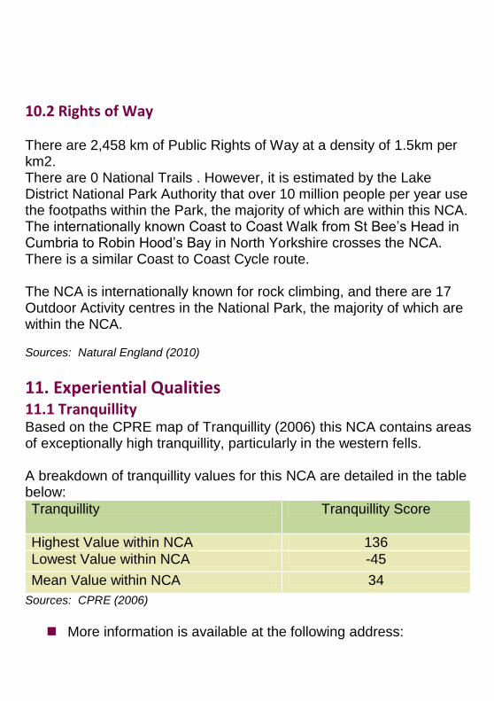
10.2 Rights of Way There are 2,458 km of Public Rights of Way at a density of 1.5km per km2. There are 0 National Trails . However, it is estimated by the Lake District National Park Authority that over 10 million people per year use the footpaths within the Park, the majority of which are within this NCA. The internationally known Coast to Coast Walk from St Bee‟s Head in Cumbria to Robin Hood‟s Bay in North Yorkshire crosses the NCA. There is a similar Coast to Coast Cycle route. The NCA is internationally known for rock climbing, and there are 17 Outdoor Activity centres in the National Park, the majority of which are within the NCA. Sources: Natural England (2010)
11. Experiential Qualities
11.1 Tranquillity
Based on the CPRE map of Tranquillity (2006) this NCA contains areas of exceptionally high tranquillity, particularly in the western fells. A breakdown of tranquillity values for this NCA are detailed in the table below:
Tranquillity Tranquillity Score
Highest Value within NCA 136
Lowest Value within NCA -45
Mean Value within NCA 34
Sources: CPRE (2006)
More information is available at the following address:
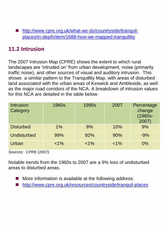
11.2 Intrusion The 2007 Intrusion Map (CPRE) shows the extent to which rural landscapes are „intruded on‟ from urban development, noise (primarily traffic noise), and other sources of visual and auditory intrusion. This shows a similar pattern to the Tranquillity Map, with areas of disturbed land associated with the urban areas of Keswick and Ambleside, as well as the major road corridors of the NCA. A breakdown of intrusion values for this NCA are detailed in the table below.
Intrusion Category
1960s 1990s 2007 Percentage change (1960s-2007)
Disturbed 1% 8% 10% 9%
Undisturbed 99% 92% 90% -9%
Urban <1% <1% <1% 0%
Sources: CPRE (2007)
Notable trends from the 1960s to 2007 are a 9% loss of undisturbed areas to disturbed areas. More information is available at the following address:
Countryside Quality Counts, Natural England (Countryside Agency 2003)
Agricultural Census June Survey 20002009, Defra (2010)
Intrusion Map, CPRE (2007)
Tranquillity Map, CPRE (2006)
Draft Historic Profiles, English Heritage (2004)*
For further information on Natural England data sources please see the Key
facts and data interpretation note
Please note all figures contained within the report have been rounded to the nearest unit. For this reason proportion figures will not (in all) cases add up to 100%. The convention <1 has been used to denote values less than a whole unit.