2º CICLO EM SISTEMAS DE INFORMAÇÃO GEOGRÁFICA E ORDENAMENTO DO TERRITÓRIO Current and future hospital locations in Vanuatu: A GIS Contribution within Vanuatu Health Policy Charlington Leo M 2017
Transcript
2º CICLO EM SISTEMAS DE INFORMAÇÃO GEOGRÁFICA E ORDENAMENTO DO TERRITÓRIO
Current and future hospital locations in Vanuatu: A GIS Contribution within Vanuatu Health Policy Charlington Leo
M 2017
Charlington Leo
Current and future hospital locations in Vanuatu: A GIS
Contribution within Vanuatu Health Policy
Dissertation of Master in Geographical Information Systems and Spatial Planning
Supervisor: José Augusto Alves Teixeira
Co-supervisor: Elsa Maria Teixeira Pacheco
Faculty of Arts, University of Porto
June 2017
Current and future Hospital locations in Vanuatu: A GIS
Index of Figures ................................................................................................................................... 7
Index of Tables ........................................................................................................................................ 8
Index of Charts ........................................................................................................................................ 9
According to (Brabyn & Skelly, 2002), Geographical access to New Zealand hospitals by
the people are best explained and assess by GIS. GIS data layers are used to see the level
or access in terms of time and distance travelled to nearby hospitals. Having figure that
out they find better ways using constraints from these variables to plan effective or
optimal sites to build new hospitals to ease access for the population. In the study
conducted by (Mohammad, Ali, & Abbas, 2009),Another way they use GIS for health
planning is the use of Accessibility Index that sees the ratio of Population density and the
travel time to hospitals or health centres nearby. This implies that GIS is vital for effective
planning in health especially the locations to establish new health facilities that is fair to
all in terms of ease of access, same distance covered to reach the facilities.
2.4 Using GIS for Planning: Challenges
The use of GIS for planning is widely used around the globe and reduce costs and time
to provide solutions relating to all the sectors particularly for health. Though the use of
GIS is promising, there are challenges arising also when entire dependency on GIS.
According to a review of study in Indonesia (Niel & Pat, 2003), Data limitation is main
24
challenge for the use of GIS for malaria research and control. This is due to lack of finance
to fund the data collection and conversion paper maps as well as data to digital format to
use for research and analysis of Malaria. The same applies for data for location of health
facilities and other infrastructure that will aid the effective planning for new health
facilities such as hospitals and health centres.
Another challenge of using GIS is lack of qualified human resources to work and use GIS.
Since GIS uses new technology, there is need to train the current human resource the
skills needed to work with and that goes with the cost to provide trains as well. In addition
to knowledge about GIS, decision-makers do not understand its application. Therefore,
the motivation to get financial support to do the work of GIS for health is not that
effective. Lack of software to perfume spatial analysis and its tasks are not that well
understood. Moreover, these software’s are controlled in powerful countries like Europe
and United states (Niel & Pat, 2003). This affects how to get copies of the software’s or
getting support for the software should problems are encountered.
25
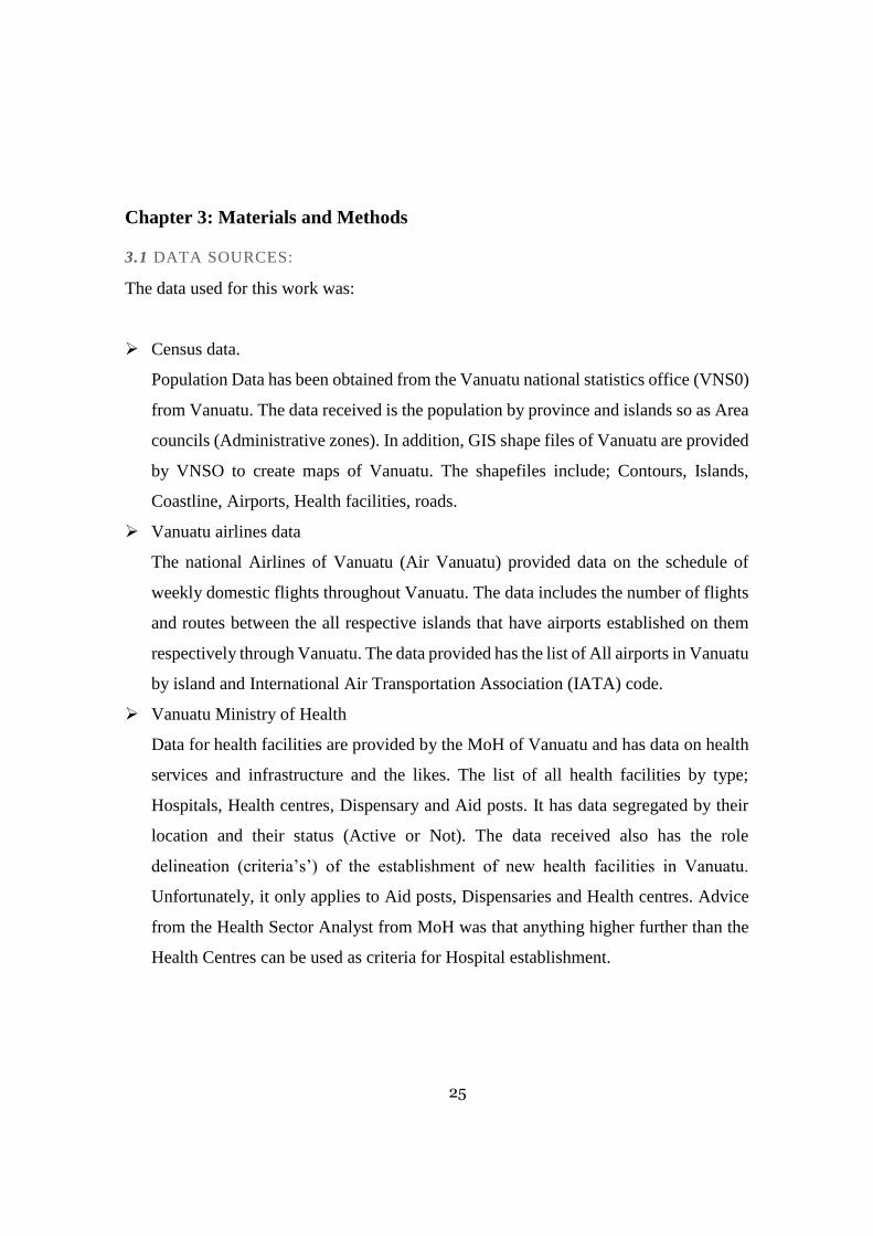
Chapter 3: Materials and Methods
3.1 DATA SOURCES:
The data used for this work was:
➢ Census data.
Population Data has been obtained from the Vanuatu national statistics office (VNS0)
from Vanuatu. The data received is the population by province and islands so as Area
councils (Administrative zones). In addition, GIS shape files of Vanuatu are provided
by VNSO to create maps of Vanuatu. The shapefiles include; Contours, Islands,
Coastline, Airports, Health facilities, roads.
➢ Vanuatu airlines data
The national Airlines of Vanuatu (Air Vanuatu) provided data on the schedule of
weekly domestic flights throughout Vanuatu. The data includes the number of flights
and routes between the all respective islands that have airports established on them
respectively through Vanuatu. The data provided has the list of All airports in Vanuatu
by island and International Air Transportation Association (IATA) code.
➢ Vanuatu Ministry of Health
Data for health facilities are provided by the MoH of Vanuatu and has data on health
services and infrastructure and the likes. The list of all health facilities by type;
Hospitals, Health centres, Dispensary and Aid posts. It has data segregated by their
location and their status (Active or Not). The data received also has the role
delineation (criteria’s’) of the establishment of new health facilities in Vanuatu.
Unfortunately, it only applies to Aid posts, Dispensaries and Health centres. Advice
from the Health Sector Analyst from MoH was that anything higher further than the
Health Centres can be used as criteria for Hospital establishment.
26
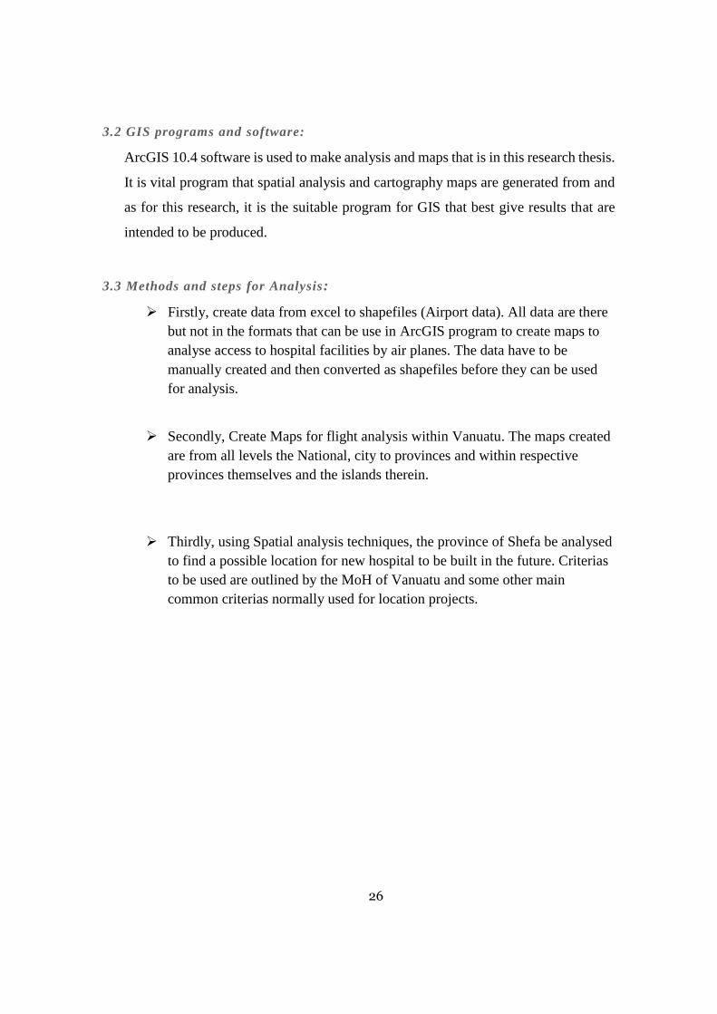
3.2 GIS programs and software:
ArcGIS 10.4 software is used to make analysis and maps that is in this research thesis.
It is vital program that spatial analysis and cartography maps are generated from and
as for this research, it is the suitable program for GIS that best give results that are
intended to be produced.
3.3 Methods and steps for Analysis:
➢ Firstly, create data from excel to shapefiles (Airport data). All data are there
but not in the formats that can be use in ArcGIS program to create maps to
analyse access to hospital facilities by air planes. The data have to be
manually created and then converted as shapefiles before they can be used
for analysis.
➢ Secondly, Create Maps for flight analysis within Vanuatu. The maps created
are from all levels the National, city to provinces and within respective
provinces themselves and the islands therein.
➢ Thirdly, using Spatial analysis techniques, the province of Shefa be analysed
to find a possible location for new hospital to be built in the future. Criterias
to be used are outlined by the MoH of Vanuatu and some other main
common criterias normally used for location projects.
27
Chapter 4: Results and Discussion
4.1 Health services and access: Vanuatu global view
The geography of Vanuatu is typical and uniquely comprised of remotely located
islands that stretched in a Y shape chain of Volcanic islands which makes analysis quite
a challenge. GIS however ease the challenge using several types of data like
administrative data and national data that is made available from the government and
other private institutions. Due to the lack of some data for analysing Health services at
health facilities and access, these research tries to analyse how the people of Vanuatu
access health services by using Airlines (Planes) that are beyond the capabilities of Health
centres, Dispensaries and Aid posts in the rural communities in Vanuatu.
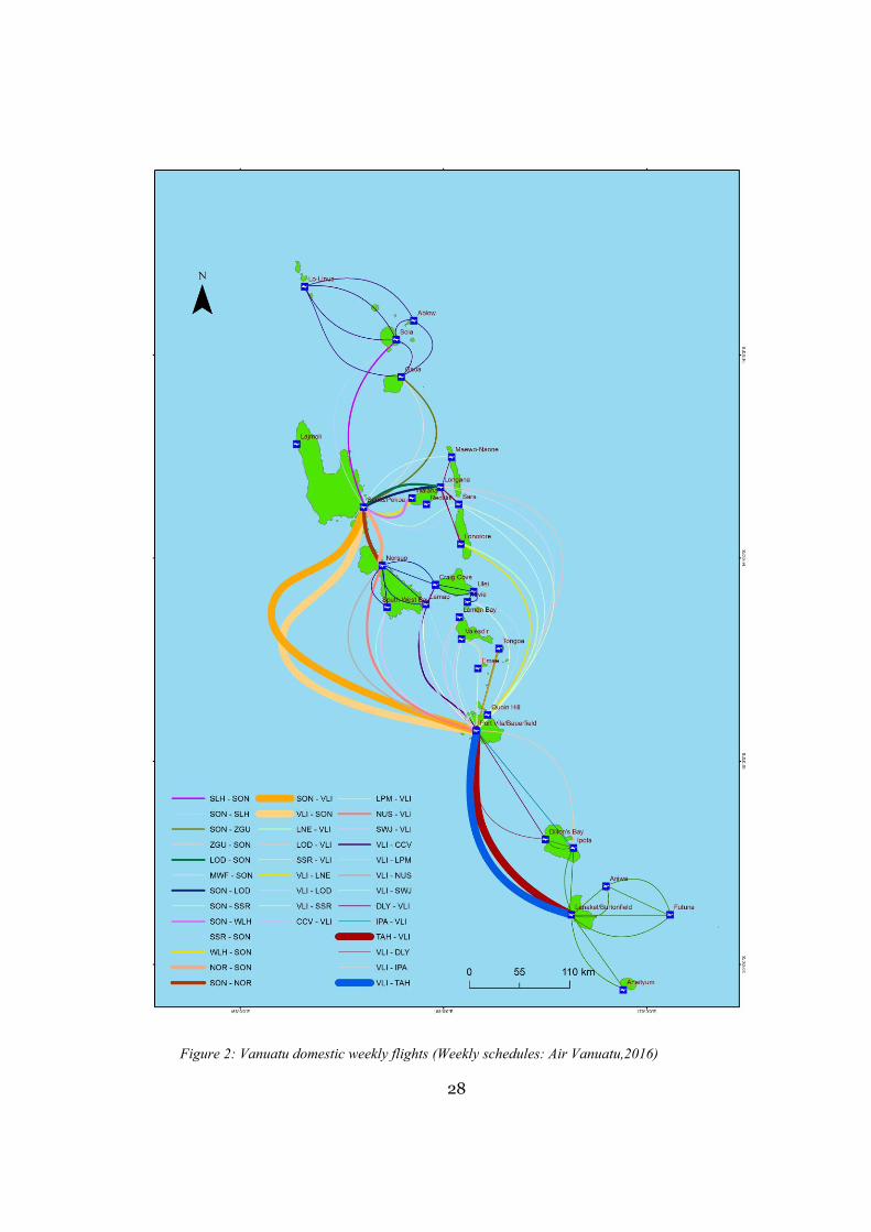
The trends of domestic flights in Vanuatu originates from the two main air ports at
both Urban centres in Vanuatu; Port Vila/Bauerfield on Efate island and Santo/Pekoa
airport on Santo island. The routes either started from one town and ends in the other after
passing through the islands on different days and different times. According to figure 2,
the flight routes and number of flights makes total sense in the context of people moving
to certain points or places in huge numbers. Most either move to their provincial centre
to access services and in the case of this research they travel to get medical help from
hospitals. Access is only possible when the medium of transportation is available to move
people between their homes to services centres (PWC, 2014). For Vanuatu generally, as
depicted by in figure 2 that almost all major islands have airports that allows the people
to travel from islands to their provincial hospitals to receive treatment.
Torba, Penama and Malampa province are in the northern and central of Vanuatu
and have flights connected to Luganville, Santo. Some people travel to Santo first before
connecting to Port Vila via the flights going to Vila from Santo if Luganville is not their
destination. An explanation that could be drawn from the flight routes and numbers shows
the direction from provincial hospitals to NDH for sickness that could not be taken care
of. Similarly, is the case for flights from Malampa, Penama and Tafea flights that connects
to Port Vila on Efate. VCH is the referral for untreatable cases and sickness in the
provinces, thus, the patients are flown to the Capital for treatment.
28
Figure 2: Vanuatu domestic weekly flights (Weekly schedules: Air Vanuatu,2016)
29
4.2 The movement of people between provinces and the two referral hospitals by
plane: Northern District Hospital(NDH) and Vila Central Hospital (VCH).
Figure 3: Flights between Luganville and Torba Province (Weekly schedules: Air
Vanuatu, 2016)
30
Figure4: Flights between Santo and Malampa province (Weekly schedules: Air Vanuatu,2016)
31
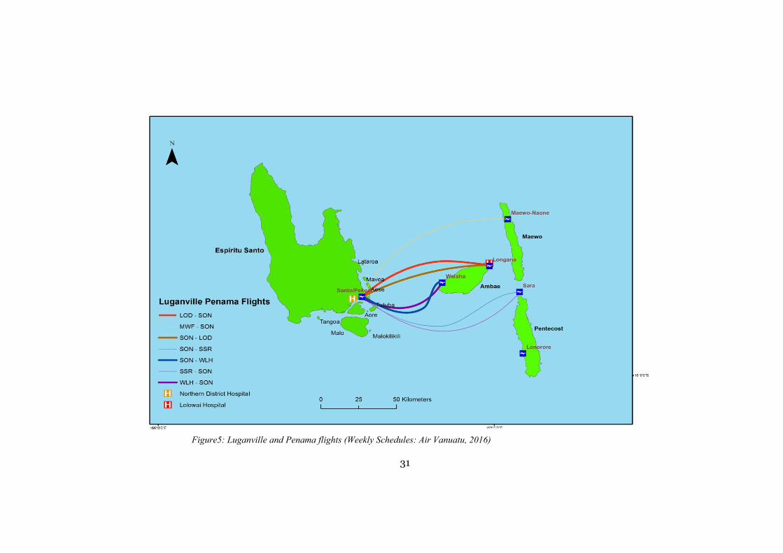
Figure5: Luganville and Penama flights (Weekly Schedules: Air Vanuatu, 2016)
32
Luganville, Santo receives flights from Torba, Malampa and Penama province. The
flights between Torba and Santo are from Gaua and Vanua Lava (see Figure 3).
Information represented on the map shows that flights from Sola Airport (SLH) to Santo-
Pekoa (SON) and SON to Gaua Airport (ZGU) are many in number compare to the other
two flight routes presented on the map. The thicker the flight route the higher the number
of Flights per week. Therefore, health wise, those flights are of which people or sick
patients are transported to Luganville for complex diseases like surgery or the likes.
Figure 4 shows the flights from Luganville to Malampa and vice versa which shows
significant number of flights in both direction of the flight routes. However, there are
more flights between Luganville and Malampa than with Torba. This might be due to the
fact that for Malampa, the only flights to Santo is from Malekula island alone, thus all
islands in Malampa province going to Santo for medical services have to connect through
or fly from Norsup airport (NUS). For people who are sick and going to Santo flying from
Malekula is reasonable as they may have been sent from Norsup Hospital which is also
in the same area as the airport.
The flights between Penama and Luganville shows that more flights in both
direction are from Ambae compared to Pentecost and Maewo island (Figure 5). Lolowai
hospital is located on Ambae approximately 5 kilometres from Longana (LOD).
Figure 6 presents the flight routes down the southern side of Vanuatu especially
connecting the flights to and from Port Vila-Bauerfield Airport(VLI) to Penama province.
In opposition to the flights between Penama and SON, most flights are between Pentecost
and VLI compare to Ambae and Maewo. As for analysis of people seeking further
treatment from VCH, most are flown directly from Pentecost island while the rest from
LOD whereby they might have been referred to VCH by Lolowai hospital. Also reading
from the map in Figure 6, more flights both ways is higher for Lonorore (LNE) compared
to the other two air ports.
Similarly, VLI has flights also from Malampa province like SON in Santo (Figure
7). NUS have more number of flights to and from VLI than other airports within the
province that has direct flights to the capital. However, Malampa is the only province that
33
has direct flights from all airports to Port Vila-Bauerfield airport regardless of the number
of flights as shown in the flight route thickness. Thus, it is easier and efficient way to
transport emergency patients or regular sick people to get medical services in VCH in Port
Vila.
Port Vila and Tafea flights has much more flights per week compared to all other
provinces of Vanuatu. VLI and Lenakel Airport (TAH) has around 10 flights respectively
each direction of the route (Figure 8). Erromango also some direct flights to Port Vila but
low in number of flights. Tafea provincial hospital (Lenakel) also is in the same area as
the airport (TAH). All the surrounding islands of Tafea province travel to Lenakel to
access services provided by the hospitals. However, if situation gets out of hand that is
when they refer them to VCH which from the analysis shown by the map would evidently
meant they travel from TAH to VLI for emergencies or referral.
the flights between the two urban areas; the Capital Port Vila and the second town
Luganville is as high as the number of flights between VLI and TAH in Tafea. In both
towns, the location of hospitals is closed to the airports (Figure 9). Though both are
regarded as referral VCH seems to be the higher standard and NDH sometimes send
patients to VCH for the final decision on treatment. People travel through the two areas
in search for their own plans or work yet it could be refer as also travelling to sought
anything health related even if it’s just regular check-up.
34
Figure 6: Port Vila and Penama flights (Weekly schedules: Air Vanuatu,2016)
35
Figure 7: Port Vila and Malampa flights (Weekly schedules: Air Vanuatu,2016)
36
Figure 8: Port Vila and Tafea flights (Weekly schedules (Air Vanuatu, 2016)
37
Figure 9: Port Vila and Luganville flights (Weekly Schedule: Air Vanuatu,2016)
38
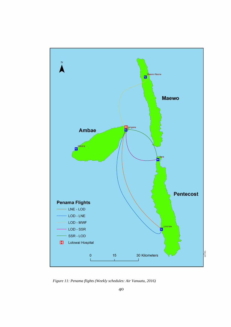
4.3 Flights within respective provinces to access services from their provincial
hospitals.
Accessing health services at a provincial level within each province was governed
by the provincial government of all provinces. They are responsible for the regular supply
of medical supply and maintenance of their hospitals. Figure 10 shows the flight routes
with Torba province in a week and clearly how most flights come in and out of Sola
(SLH) which is the provincial Headquarter and where Qaet Vaes hospital is located.
The flights that intercepted through come from both with Banks islands and the
Torres group which ideally depict that sick patients travel to Vanua Lava island to sought
medical help. Figure 11 similar shows the same pattern of movement through main
headquarter except this time in Penama province. All flights have the connection at LOD
which is also exactly on Ambae and close to Lolowai hospital.
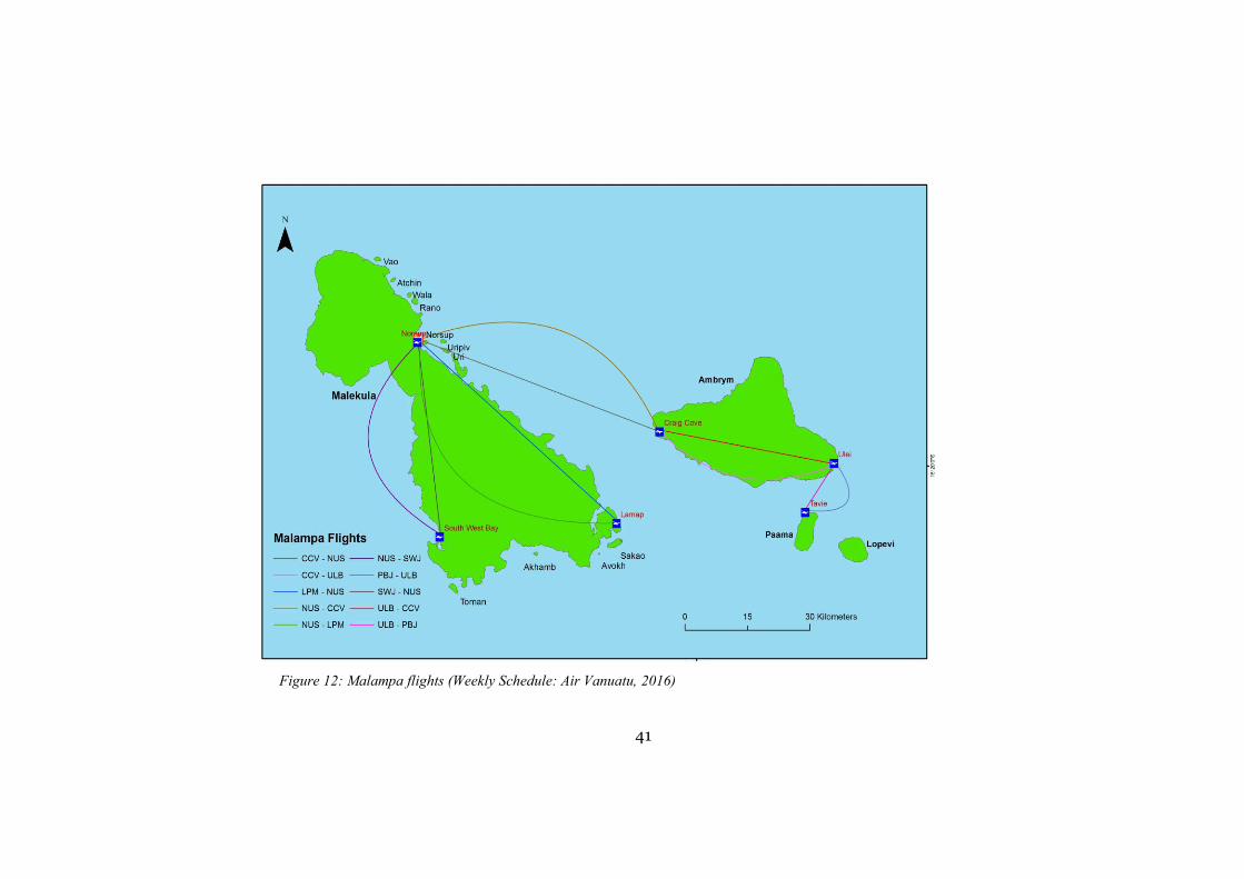
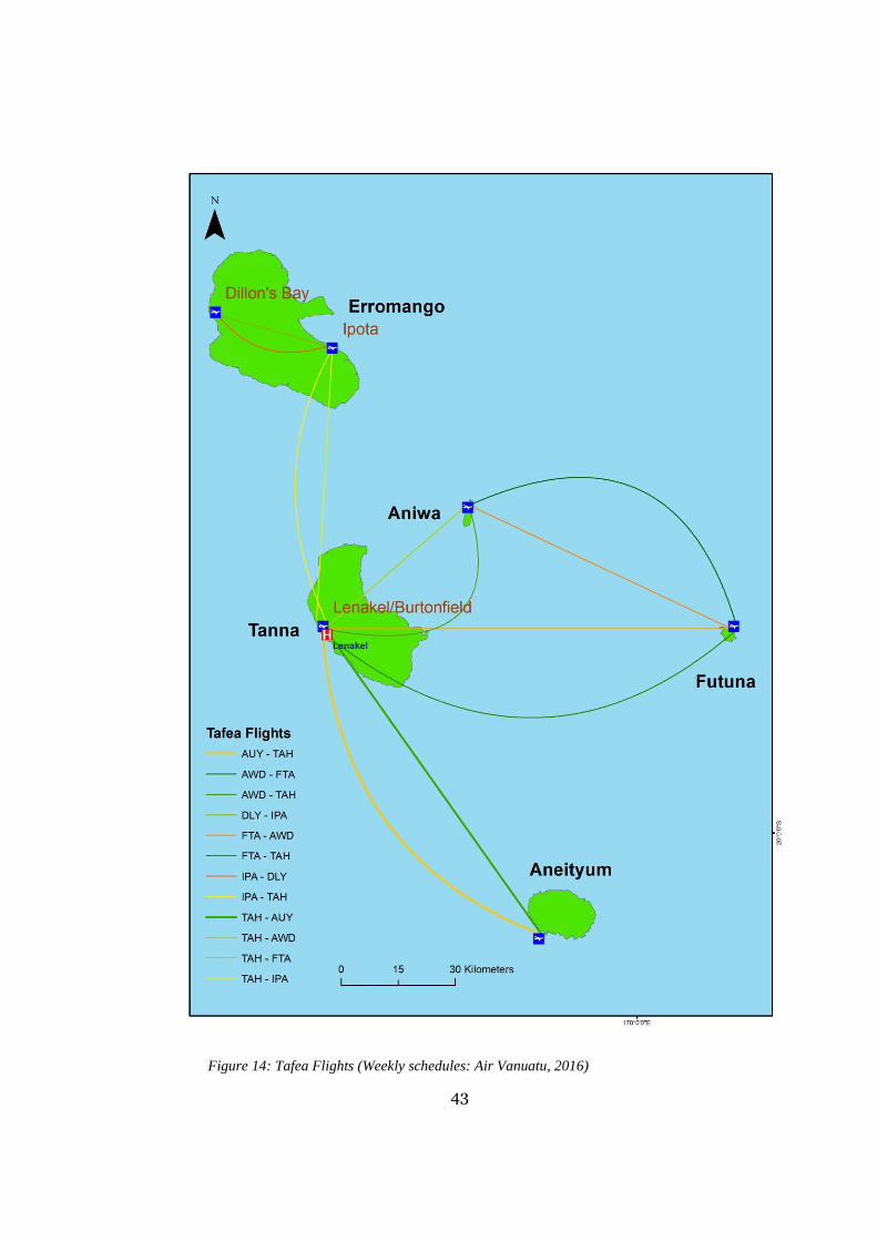
In addition, the flight routes within Malampa (Figure 12), Shefa (Figure 13) and
Tafea Province (Figure 14) shows the same pattern of flight routes and concentrations.
All the infrastructure of health and Air transportation are closely located and make access
to each of the services and facilities very easy and efficient. Therefore, as a criterion for
the finding suitable location, the access and closeness of areas with such infrastructure it
can be said that it has met the criteria.
39
Figure 10: Torba flights (Weekly schedules: Air Vanuatu,2016)
40
Figure 11: Penama flights (Weekly schedules: Air Vanuatu, 2016)
41
Figure 12: Malampa flights (Weekly Schedule: Air Vanuatu, 2016)
42
Figure 13: Shefa flights (Weekly schedules: Air Vanuatu, 2016)
43
Figure 14: Tafea Flights (Weekly schedules: Air Vanuatu, 2016)
44
Chapter 5: Conclusion and Recommendation
5.1 Conclusion
Upon completion of this research, the objectives are quite achieved. The analysis of the
current hospital locations all follow the pattern of locating near airports which makes it
accessible to people and not isolated from other services that people needed daily. The
schedules and flight routes per week varies from provinces and more flights are between
Santo and Port Vila so as Port Vila and Tanna island.
The need of finding a best suitable area for a new hospital is a challenge especially in
Shefa province as not all data needed are available but should they had been, it would
ease the burden. Population is increasing and so is the need for new hospitals to be built
to cater for the additional to current population.
5.2 Recommendations
To improve this research in the future here are some areas to improve:
➢ Make sure all administrative data are available. The government or private
institutions should invest in creating data or databases to capture information of
transportation by Boats with each island and the purpose of service. Also,
Transport and buses on land that transport people to get medical help from health
facilities.
➢ The government through the MoH to create new role delineation that provides the
requirements of building new Health facilities.
45
Bibliography
Brown A, Gilbert B. (2012, 07 23). The Vanuatu Medical supply system - documenting opportunities and challenges to meet the Millennium Development Goals. Southern Med Review, 14 - 21. Retrieved from Southern Med Review.
Administrator. (2015). Vanuatu Ministry of Health. Retrieved from Vanuatu Government Ministries: www.moh.vu/
Air Vanuatu. (2016, November). Weekly schedules. Port Vila, Shefa Province, Vanuatu. Archer, L. (2014, 02 12). Using Geographic information Systems(GIS) Mapping for Better Health
Planning-Binduri District. Retrieved 07 13, 2016, from Advanceing Research on Comprehensive Health Systems: http://arches.columbia.edu/using-geographic-information-system-gis-mapping-for-better-health-planning-binduri-district/
Brabyn , L., & Skelly, C. (2002). Geographical Access to Services, Health (GASH): Modelling Population Access to New Zealand Public Hospitals. International Journal of Health Geographics.
European Union - The Pacific Islands Forum Secretariat, Pacific Regional Indicative Programme for the period 201-2020. (2015, 07 02). Retrieved 07 14, 2016, from eeas.europa.eu: https://eeas.europa.eu/pacific/documents/eu-pifs-signed-2014-2020_en.pdf
FLETCHER-LARTEY1, S. M., & CAPRARELLI, G. (2016). Application of GIS technology in public health: successes and challenges. Parasitology, 401- 4 15.
Indexmundi. (2011). Vanuatu. Retrieved from Index Mundi: http://www.indexmundi.com/vanuatu/#Health
MoH. (2004). Vanuatu Health Policy . Port Vila: Ministry of Health (MoH). Mohammad, H. V., Ali, A. A., & Abbas, A. (2009). Hospital site seelection ussing fuzzy AHP and
its derivatives. Journal of Environmental Management, 3048-3056. Niel, G. S., & Pat, D. (2003). Challenges in using geographic information systems (GIS) to
understand and control malaria in Indonesia. Malaria Journal, 1- 8. Retrieved 06 14, 2017
PWC. (2014, 10). Infrastructure Development in Asia Pacific (APEC) The next 10 years. Retrieved 07 14, 2016, from www.pwc.com: https://www.pwc.com/gx/en/capital-projects-infrastructure/assets/infrastructure-development-in-asia-pacific.pdf
United Nations, (. (2010). The Millennium Development Goals Report United Nations. Retrieved from un.org: http://www.un.org/millenniumgoals/pdf/MDG%20Report%202010%20En%20r15%20-low%20res%2020100615%20-.pdf
Vanuatu MoH. (2004). Ministry of Health - Master Health Services Plan 2004-2009. Retrieved from Wpro.who.int: http://www.wpro.who.int/countries/vut/VanuatuHealthMasterPlan_LIGHTVERSION.pdf
Vanuatu National Statistics Office. (2015). Retrieved 07 13, 2016, from VNSO: http://www.vnso.gov.vu/index.php/census-and-surveys/censuses
WHO. (2013, 10). Country Cooperation Strategy at a glance: Pacific Island Countries. Retrieved 07 02, 2016, from World Health Organization: http://www.who.int/iris/handle/10665/136831
46
47
Anex 1
Name of
Facility Designation Province Island
Health
Zone Lat. Long. Ownership Setting Status
Norsup Hospital Malampa Malakula MAL01 -
16.06438 167.39959 MOH Rural Open
Lolowai Hospital Penama Ambae PEN01 -
15.28029 167.98206 MOH Rural Open
Northern District Hospital Sanma Santo SAN01 -
15.50870 167.18374 MOH Urban Open
Vila Central Hospital Shefa Efate SHE01 -
17.73560 168.32291 MOH Urban Open
Lenakel Hospital Tafea Tanna TAF01 -
19.53045 169.2741 MOH Rural Open
Qaet Vaes Hospital Torba Vanua
Lava TOR03
-
13.86723 167.54117 MOH Rural Open
Hospital facilities and information (MoH,2016)
48
Anex 2
Snap shots of the table from Air Vanuatu containing the weekly flight schedule last year 2016 (Weekly schedules: Air Vanuatu, 2016)
49
50
51
Snap shot of the page with Role delineation of Health facilities from the Vanuatu Health policy (2004).