Page 1
CURRICULUM FOR
Department Surveying Technology
Major
Surveying
Semesters 1437H - May 2016
Bachelor's Degree
KINGDOM OF SAUDI ARABIA Technical and Vocational Training Corporation Director General for Curricula Design & Development
Qualification for Technical Colleges
Page 2
KINGDOM OF SAUDI ARABIA Technical and Vocational Training Corporation
Directorate General for Curricula Design & Development
Surveying Technology
Surveying
1
Program Description:
This program of Geometrics Surveying is designed so as to meet the training needs of the local
labor market, following professional International standards set for Surveying Engineering Technology.
Training in this program includes general skills in English, physics, statistical methods,
mathematics and professional ethics, methods of human communication, interaction skills, project
management, Quality management and leadership.
It also includes training on computer programing as well as specialized skills in the field of
Geometrics, such as: Geodesy, theory of errors and adjustment, map projections and making, advance
topics in GIS, spatial databases, mine surveying, hydrographic surveying, and surveying applications by
computer software, remote sensing and digital photogrammetry.
In this training program the trainees spend (1616) training hours in college in addition to (490)
hours of training in the labor market as a cooperative program.
The graduates of this program will be given a bachelor degree in “Surveying”. Graduates of this
program must demonstrate:
1- The ability to analyze, design, and implement surveying projects, GIS data, and remote sensing
applications .
2- The ability to apply project management techniques to surveying projects.
3- The ability to utilize statistics/probability, transform methods, discrete mathematics, or applied
differential equations in handling with surveying process.
Index Content Page 1 Program description 1
2 Index 1
3 Study plan 2
4 Brief description 4
5 Description of major courses 6
Page 3
KINGDOM OF SAUDI ARABIA Technical and Vocational Training Corporation
Directorate General for Curricula Design & Development
Surveying Technology
Surveying
2
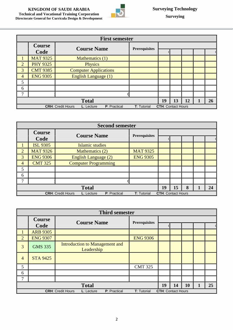
First semester
Course
Code Course Name Prerequisites
No. of Units CRH L P T CTH
1 MAT 9325 Mathematics (1) 3 2 2 0 4
2 PHY 9325 Physics 3 2 2 0 4
3 CMT 9385 Computer Applications 2 0 4 0 4
4 ENG 9305 English Language (1) 3 3 0 1 4
5 SRV 375 Geodesy 3 2 2 0 4
6 SRV 355 Map Making & Projections 2 2 0 0 2
7 SRV 9376 Geographic Information Systems (1) 3 2 2 0 4
Total 19 13 12 1 26
CRH: Credit Hours L: Lecture P: Practical T: Tutorial CTH: Contact Hours
Second semester
Course
Code Course Name Prerequisites
No. of Units CRH L P T CTH
1 ISL 9305 Islamic studies 2 2 0 0 2
2 MAT 9326 Mathematics (2) MAT 9325 3 2 2 0 4
3 ENG 9306 English Language (2) ENG 9305 3 3 0 1 4
4 CMT 325 Computer Programming 3 2 2 0 4
5 SRV 356 Survey Applications 2 2 0 0 2
6 SRV 377 Remote Sensing 3 2 2 0 4
7 SRV 9475 Geographic Information Systems (2) SRV 9376 3 2 2 0 4
Total 19 15 8 1 24
CRH: Credit Hours L: Lecture P: Practical T: Tutorial CTH: Contact Hours
Third semester
Course
Code Course Name Prerequisites
No. of Units CRH L P T CTH
1 ARB 9305 Arabic Language 2 2 0 0 2
2 ENG 9307 English Language (3) ENG 9306 3 3 0 1 4
3 GMS 335 Introduction to Management and
Leadership 2 2 0 0 2
4 STA 9425 Engineering Statistics and
Probability 4 3 2 0 5
5 SRV 378 Spatial Databases CMT 325 3 2 2 0 4
6 SRV 379 Digital Photogrammetry SRV 377 3 2 2 0 4
7 SRV 485 Computer Survey Applications 2 0 4 0 4
Total 19 14 10 1 25
CRH: Credit Hours L: Lecture P: Practical T: Tutorial CTH: Contact Hours
Page 4
KINGDOM OF SAUDI ARABIA Technical and Vocational Training Corporation
Directorate General for Curricula Design & Development
Surveying Technology
Surveying
3
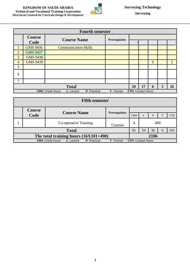
Fourth semester
Course
Code Course Name Prerequisites
No. of Units CRH L P T CTH
1 GMS 9436 Communication Skills 2 2 0 1 3
2 GMS 9437 Engineering Project Management 3 3 0 0 3
3 GMS 9438 Quality Tools and Applications 3 3 0 0 3
4 GMS 9439 Engineering Economy 2 2 0 0 2
5 SRV 435 Highway Engineering 3 2 2 0 4
6 SRV 456 Theory of Errors & Observation
Adjustment 3 3 0 2 5
7 SRV 9496 Project 4 2 4 0 6
Total 20 17 6 3 26
CRH: Credit Hours L: Lecture P: Practical T: Tutorial CTH: Contact Hours
Fifth semester
Course
Code Course Name Prerequisites
No. of Units
CRH L P T CTH
1 SRV 499 Co-operative Training Pass all
Courses 4 490
Total 81 59 36 6 101
The total training hours (16X101+490) 2106 CRH: Credit Hours L: Lecture P: Practical T: Tutorial CTH: Contact Hours
Page 5
KINGDOM OF SAUDI ARABIA Technical and Vocational Training Corporation
Directorate General for Curricula Design & Development
Surveying Technology
Surveying
4
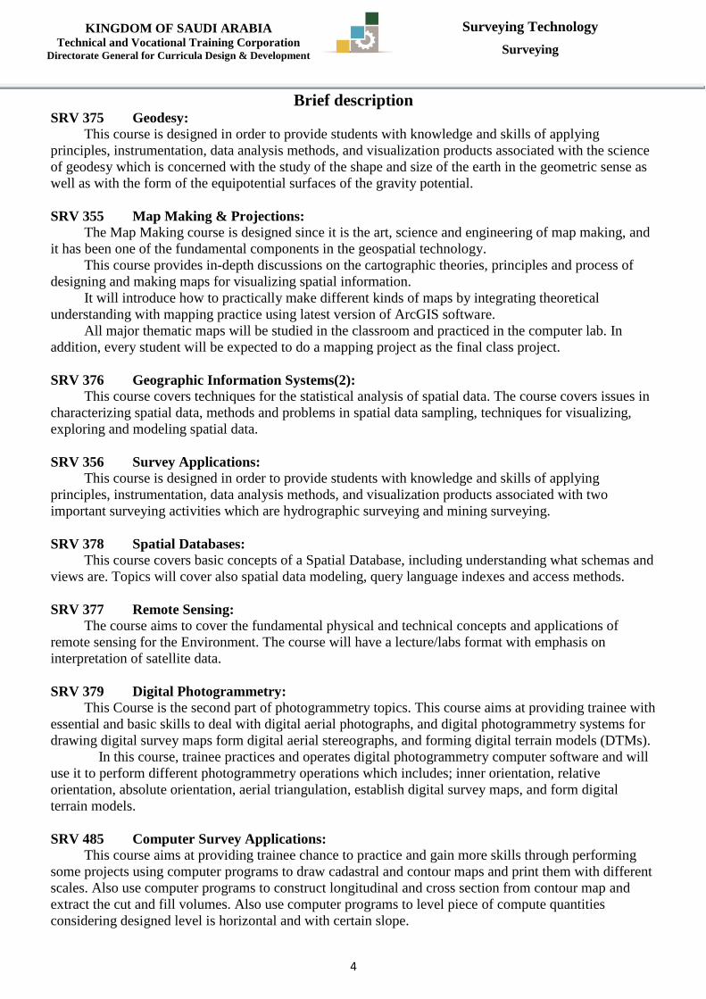
Brief description SRV 375 Geodesy:
This course is designed in order to provide students with knowledge and skills of applying
principles, instrumentation, data analysis methods, and visualization products associated with the science
of geodesy which is concerned with the study of the shape and size of the earth in the geometric sense as
well as with the form of the equipotential surfaces of the gravity potential.
SRV 355 Map Making & Projections:
The Map Making course is designed since it is the art, science and engineering of map making, and
it has been one of the fundamental components in the geospatial technology.
This course provides in-depth discussions on the cartographic theories, principles and process of
designing and making maps for visualizing spatial information.
It will introduce how to practically make different kinds of maps by integrating theoretical
understanding with mapping practice using latest version of ArcGIS software.
All major thematic maps will be studied in the classroom and practiced in the computer lab. In
addition, every student will be expected to do a mapping project as the final class project.
SRV 376 Geographic Information Systems(2):
This course covers techniques for the statistical analysis of spatial data. The course covers issues in
characterizing spatial data, methods and problems in spatial data sampling, techniques for visualizing,
exploring and modeling spatial data.
SRV 356 Survey Applications:
This course is designed in order to provide students with knowledge and skills of applying
principles, instrumentation, data analysis methods, and visualization products associated with two
important surveying activities which are hydrographic surveying and mining surveying.
SRV 378 Spatial Databases:
This course covers basic concepts of a Spatial Database, including understanding what schemas and
views are. Topics will cover also spatial data modeling, query language indexes and access methods.
SRV 377 Remote Sensing:
The course aims to cover the fundamental physical and technical concepts and applications of
remote sensing for the Environment. The course will have a lecture/labs format with emphasis on
interpretation of satellite data.
SRV 379 Digital Photogrammetry:
This Course is the second part of photogrammetry topics. This course aims at providing trainee with
essential and basic skills to deal with digital aerial photographs, and digital photogrammetry systems for
drawing digital survey maps form digital aerial stereographs, and forming digital terrain models (DTMs).
In this course, trainee practices and operates digital photogrammetry computer software and will
use it to perform different photogrammetry operations which includes; inner orientation, relative
orientation, absolute orientation, aerial triangulation, establish digital survey maps, and form digital
terrain models.
SRV 485 Computer Survey Applications:
This course aims at providing trainee chance to practice and gain more skills through performing
some projects using computer programs to draw cadastral and contour maps and print them with different
scales. Also use computer programs to construct longitudinal and cross section from contour map and
extract the cut and fill volumes. Also use computer programs to level piece of compute quantities
considering designed level is horizontal and with certain slope.
Page 6
KINGDOM OF SAUDI ARABIA Technical and Vocational Training Corporation
Directorate General for Curricula Design & Development
Surveying Technology
Surveying
5
SRV 435 Highway Engineering:
The course is presented in two strands. The first strand is concerned with the fundamentals of
highway and pavement engineering. It introduces the design process of roads and intersections, including
horizontal and vertical alignment design, cross-sections and earthworks. The second half of this strand
deals with pavement design and evaluation. Topics include pavement composition, pavement materials,
asphalt mix design, the pavement thickness design, and defects in Flexible pavements and failures in rigid
pavements.
The second strand is presents briefly bridges classification and construction methods.
SRV456 Theory of Errors & Observation Adjustment:
This course is designed for the purpose of examining the nature of measurements, statistical
analysis of random errors in measurements, propagation of errors, survey standards and design
specifications, development of coordinate geometry and trigonometric solutions of plane surveying
problems, analysis of errors and mistakes in indirect measurement.
SRV 475 Geographic Information Systems (3):
This course will describe new services, which become widely distributed through world today such
as Distributed GIS, Web Mapping, Location Based Services.
SRV 495 Project (1):
This course is the first part of applied project. Trainee gets the chance to get knowledge about
executable projects within capacity of trainee. In addition, Trainee reviews some maps and reports of
already executed projects.
Trainee should select a project in coordination with his supervisor. The selected project should meet
some standards such as: allows trainee to apply what he already have of skills and experiences during his
study. In addition, Trainee should be able to use available supplies such as computer labs, survey systems
and software, modern instruments to collect data, process and adjust data, compute final coordinates and
draw maps at required scale.
SRV 496 Project (2):
This course is the second part of applied project. Trainee gets the chance to practice using most
advanced systems to execute projects. In addition, Trainee applies his experiences in carrying out some
engineering and surveying projects.
Trainee should select a project in coordination with his supervisor. The selected project should meet
some standards such as: allows trainee to apply what he already has of skills and experiences during his
study. In addition Trainee should be able to use available supplies such as computer labs, survey systems
and software, modern instruments to collect data, process and adjust data, compute final coordinates and
draw maps at required scale, compute volumes of cut and fill from contour maps an longitudinal and
cross sections, also use available software of Remote sensing, and geographic information systems,
digital photogrammetry.
Page 7
KINGDOM OF SAUDI ARABIA Technical and Vocational Training Corporation
Directorate General for Curricula Design & Development
Surveying Technology
Surveying
6
Department Civil & Architectural Technology Major Surveying Technology
Course Name Geodesy Course Code SRV 375
Prerequisites Credit Hours
CRH 3 CTH 4
L 2 P 2 T 0
CRH: Credit Hours L: Lecture P: Practical T: Tutorial CTH: Contact Hours
Course description :
This course is designed in order to provide students with knowledge and skills of applying
principles, instrumentation, data analysis methods, and visualization products associated with the
science of geodesy which is concerned with the study of the shape and size of the earth in the
geometric sense as well as with the form of the equipotential surfaces of the gravity potential.
Topics:
Reductions And Computations For Plane Surveying Map Projections
Geographic Coordinates And Reference Ellipsoids Height systems
Geodetic Coordinate Systems
Distances, Angles and Point Positioning
Map Projections
Gravity, Geopotential, and The Geoid
Height Systems and Vertical Datum's
Tides
Earth and its Deformation in Time
Adjustment Of Level Nets
Experiments: if applicable it will support the course topics.
References:
Geodesy, Jürgen Müllerand Wolfgang Torge, 2012, de Gruyter Textbook
Details of Theoretical Contents
Contents Hours
1
Introduction:
‐ Definition and brief history of geodesy
- The three main areas of geodesy: Geometry,
Rotation , Gravity
- Physical geodesy and the need for gravity
field modeling
- Applications of geodesy in Earth science
- Applications of geodesy in engineering
2
2
Reductions And Computations For Plane
Surveying:
- Absolute versus Relative Positions
- Plane Angles
- Mathematical Tools
- The Inverse Problem in the Plane
- Reductions for Plane Surveying
- The Direct Problem in the Plane
3
3
Geographic Coordinates And Reference
Ellipsoids:
- The Need for Geodetic Surveying
- Reference Ellipsoids
3
Page 8
KINGDOM OF SAUDI ARABIA Technical and Vocational Training Corporation
Directorate General for Curricula Design & Development
Surveying Technology
Surveying
7
- Earth rotation, precession, nutation, polar motion
- Latitude and Longitude
- Types of Latitudes
4
Geodetic Coordinate Systems:
- Earth-Centered, Earth-Fixed Geocentric
Cartesian (XYZ)
- Geodetic Longitude and Latitude, and Ellipsoid
Height (LBH)
- Local Horizontal Coordinate Systems
- Reference Frames and Geodetic Datums
- Transformation Formula between reference
systems.
3
5
Distances, Angles and Point Positioning:
- Types of Distances
- Distance Reductions
- North and South
- Spherical Trigonometry
- Positioning on a Sphere
- Grid Angles
3
6
Map Projections:
- Developable Surfaces
- Map Projection Classification
- Projection Parameters
- Grid Coordinates
- Map Projection Systems
3
7
Gravity, Geopotential, and The Geoid:
- Gravity vectors and gravity potential
- The normal potential
- The GRS80 and WGS84
- Gravity instrumentation and measurements
- Terrestrial gravimetry: Spring and absolute gravity meters
- Sea and airborne gravimetry
- Satellite gravimetry
3
8
Height Systems and Vertical datum:
- Spirit leveling and the earth's gravity field
- Height from geopotential numbers
- Dynamic, normal and orthometric heights
- Leveling and optimal combination of ellipsoidal,
orthometric and geoidal heights
- Vertical datums
3
9
Tides:
-Tidal Gravitational Attraction and potential
- Ocean Tides and Body Tides
3
10
Earth and its Deformation in Time:
- Types of deformation
- Tides
- Tectonic deformations
- Postglacial rebound
- Geodetic observation of deformations
3
Page 9
KINGDOM OF SAUDI ARABIA Technical and Vocational Training Corporation
Directorate General for Curricula Design & Development
Surveying Technology
Surveying
8
11
Adjustment Of Level Nets:
- Observation Equations
- Unweighted Example
- Reference Standard Deviation
- Weighted Adjustment
3
Total 32
Textbook: Introduction to Geometrical and Physical Geodesy: Foundations of Geomatics,
Thomas H, Meyer, 2012, Esri Press.
Details of Practical Contents
Contents Hours
1
Stable (Static) Gravimetry Measurement:
- Askania
- Boliden
- Gulf (hoyt)
8
2
Unstable (Astatic) Gravimetry Measurement:
- - Thyssen
- La Coste-Romberg
- Worden
8
3
Height Systems and Vertical datum:
- Dynamic heights
- Normal heights
- Orthometric heights
8
4
- - Global Navigation Satellite System (GNSS) 8
Total 32
Textbook:
Page 10
KINGDOM OF SAUDI ARABIA Technical and Vocational Training Corporation
Directorate General for Curricula Design & Development
Surveying Technology
Surveying
9
Department Civil & Architectural Technology Major Surveying Technology
Course Name Map Making & Projections Course Code SRV 355
Prerequisites Credit Hours
CRH 2 CTH 2
L 2 P 0 T 0
CRH: Credit Hours L: Lecture P: Practical T: Tutorial CTH: Contact Hours
Course description :
The Map Making course is designed since it is the art, science and engineering of map
making, and it has been one of the fundamental components in the geospatial technology. This
course provides in-depth discussions on the cartographic theories, principles and process of
designing and making maps for visualizing spatial information. It will introduce how to practically
make different kinds of maps by integrating theoretical understanding with mapping practice using
latest version of ArcGIS software. All major thematic maps will be studied in the classroom and
practiced in the computer lab. In addition, every student will be expected to do a mapping project as
the final class project. Topics :
The purpose of this course is to develop student's skills in map use and analysis as well as to
develop his map-making skills by applying cartographic theory to computer cartographic software.
The computer and associated peripherals (the graphics screen, printers and plotters) replace the pen
and drafting board as the means to map productions. Through a series of lectures and lab exercises,
student will not only develop his cartographic skills, but also become comfortable working in a
computer environment. On successful completion of this course, student will be able to be a map
maker and will have the sufficient knowledge concerning the fundamental components of the
geospatial technology.
Experiments: If applicable, it will support the course topics.
References :
1. Map Use and Analysis. (Campbell 2012)
2. Thematic Cartography and Geographic Visualization (Slocum et al. 2011)
3. ArcGIS™ version 10 or 10.1 from ESRI, User's Guide
Details of Theoretical Contents
Contents Hours
1
Introduction to Thematic Mapping:
- Map Definition
- Definition of Cartography
- Geographic Cartography
- Kinds of Maps
- Map Scale
- Modern Views of Map Communication
- Cartography and Geographic Information Systems
- Cartographic Abstraction and Generalization
- Selection
- Classification
- Simplification
- Symbolization
- Map Design
-Definition of Map Design
-Ethics in Cartography
2
Basic Geodesy, Coordinate Systems, and Scale:
Page 11
KINGDOM OF SAUDI ARABIA Technical and Vocational Training Corporation
Directorate General for Curricula Design & Development
Surveying Technology
Surveying
11
2
- Basic Geodesy: The Size and Shape of the Earth
- Coordinate Geometry for the Cartographer
- The Geographic Grid
- Principal Geometric Relationships of the Earth’s
Geographic Grid
-Linear
-Angular
-Azimuth
- Area
-Points
-Circles on the Grid - Scale Concept: Scale and Line Generation
2
3
Map Projections:
-The map Projection Process
-Developable Surfaces
-Projection Parameters
-Azimuthal projection
-Cylindrical projection
-Conic projection -Mathematical projection
-Equal Area projection
-Conformal Mapping
-Equidistance Mapping
-Minimum Error Projections
-Deformation and its Distribution Over the
Projection
-Standard Lines and Points, Scale Factor
-World Projections
-Mathematical, Equivalent Projections
-Minimum Error Projections
-Cylindrical Projections
-Projected Coordinate Systems
-National (Saudi) Plane Coordinate System
-Universal Transverse Mercator (UTM)
System
2
4
The Nature of Geographic Data and the
Selection of Thematic Map Symbols:
-The Nature of Data
-Data Characteristics
-Location
-Point Data
-Line Data
-Area Data
-Form
-Qualitative/Quantitative Context
-Spatial Context
-Attribute Context
-Time
-Data Transformations
-Scale
2
Page 12
KINGDOM OF SAUDI ARABIA Technical and Vocational Training Corporation
Directorate General for Curricula Design & Development
Surveying Technology
Surveying
11
-Form
-Boundary Changes
-Data Measurement
-Nominal
-Ordinal
- Interval
-Ratio
-Data: Thematic Map Relationships
-Map Symbols
-Visual Variables
-Size
-Shape
-Orientation
-Texture
-Saturation and Value
-Cartographic Error -Source Error
- Processing Error
- Cartographic Design Error
5
Descriptive statistics and Data Classification:
-Overview of a Data Sheet
-Ratio, Proportion, Percent, and Rate
-Descriptive Statistics
-Data Classification
-Selection of the Number of Classes
-Data Classification Schemes
-Natural Breaks
-Nested Means
-Mean and Standard Deviations
-Equal Interval
-Equal Frequency
-Arithmetic and Geometric Intervals -User Defined
2
6
Mapping Enumeration and Other Areally
Aggregated Data: The Choropleth Map:
-Selecting the Choropleth technique
-Mapping Rationale
-Appropriateness of Data
-Preliminary Considerations in Choropleth
Mapping
-Geographic Phenomena
-Map Scale
-Number and Kinds of Enumeration
Units
-Data Processing
-Data Classification Revisited
-Classification Methods Compared
-Data Truncation and Outliers
- Different Maps from the Same Data
-Unclassed Choropleth Maps
-Legend Design Symbolization, and Base Map
3
Page 13
KINGDOM OF SAUDI ARABIA Technical and Vocational Training Corporation
Directorate General for Curricula Design & Development
Surveying Technology
Surveying
12
Design
-Sources of Map-Reading Error and the
Need for Accurate Design Response
-Legend Design
-Box Shape, Size, Orientation, and
Range Placement
-Continuous and Noncontiguous Class
Ranges
-Class Range Formatting, Legend
Titles, and Other Legend – Information
-Map Sequences and Animated Maps
Considerations
-Symbolization for Choropleth Maps
- Black and White Mapping
-Color Map Symbolization
-Bipolar and Bivariate Symbolization
-Adding Other Reference Features to the Map
7
The Dot Density Map:
-Mapping Technique
-Advantages and Disadvantages of Dot
Density Mapping
-Data Suitability
-The Mapping Activity
- Size of Enumeration Unit
-Dot Value and Size
-Dot Placement
-Legend Design
2
8
From Point to Point: The Proportional Symbol
Map:
-Conceptual Basis For Proportional Point Symbol
Mapping
-Selecting Method—Data Suitability
- A Variety of Symbol Choices
-Two-Dimensional Geometric Symbols
-Three-Dimensional Geometric Symbols
- Pictorial Symbols
- Proportional Symbol Scaling
-Absolute and Apparent Magnitude Scaling
-Thematic Map Symbols
-Absolute Scaling with Circles
-Apparent Magnitude Scaling with
Circles
-The Square Symbol
-Range Grading
- Proportional Symbol Legend Design
2
Mapping Geographic Surfaces:
-The Nature of Isarithmic And Three Dimensional
Mapping
-Isarithmic Categories and Terminology
-The Basis of Isarithmic Construction
-A Brief History of Isarithmic Mapping
-Selecting the Isarithmic Method
2
Page 14
KINGDOM OF SAUDI ARABIA Technical and Vocational Training Corporation
Directorate General for Curricula Design & Development
Surveying Technology
Surveying
13
9
- Isarithmic Practices
-Elements of Isarithmic Mapping
-Concepts in Isarithm Placement
- Locating Data Points
-Concept of Interpolation
-Automated Isarithmic Mapping
-Gridding Methods of Interpolation
-Evaluating Grid Error
-The Selection of Isarithmic Intervals
-Other Representations of Continuous Surfaces
-Shaded Relief Maps
-Wireframe and Surface Maps
-Communicating Using Multiple Map
Displays
-Design Aspects For Isarithmic & Continuous
Surface Maps
- Isolines and Figure-Ground Relationship
-Isoline Labels
-Legend Design
10
The Cartogram: Value-by-Area Mapping:
-The Value y-Area Cartogram Defined
- Two Basic Forms Emerge
-Contiguous Cartograms
-Noncontiguous Cartograms
-Mapping Requirements
-Data Limitations
-Communicating With Cartograms
-Recognizing Shapes
-Estimating Areas
-A Communication Model
-Advantages and Disadvantages
-Design Strategies Recap-Legends, Inset
Maps, and Labeling
-Bivariate Cartograms
-Cartogram Construction
- Manual Methods
-Automated Solutions
2
11
Dynamic Representation: The Resign Of Flow
Maps:
-The Purpose of Flow Mapping
-Quantitative Flow Maps
-Data Suitability
- Directed and Undirected Flows
-The Relevance of Flow Routes
-Designing Flow Maps
-Map Organization and Figure-Ground
-Projection Selection
-Essential Design Strategies
-Line Scaling and Symbolization
-Treatment of Symbols
-Legend Design
-Innovative Solutions
2
Page 15
KINGDOM OF SAUDI ARABIA Technical and Vocational Training Corporation
Directorate General for Curricula Design & Development
Surveying Technology
Surveying
14
12
The Map Design Process And The Elements Of
Map Composition:
-The Design Process
-Design Evaluation
-Creativity and Visualization
-Graphic Ideation
-Experimentation
-Map Aesthetics
-The Map's Design Elements
- Design Levels On The Ma0
- Elements Of Map Composition
-Purpose of Map Composition
-Planar Organization of the Visual Elements
-Balance
-Focus of Attention
-Internal Organization
-Contrast and Design
-Line Contrast
-Texture Contrast
-Value Contrast
-Variation of Detail
-Color Contrast
-Vision Acuities
-Visual Acuity
-Resolution Acuity
-The Special Case Of The Land-Water Contrast
-Vignetting for Land-Water Differentiation
-Designing Of The Page-Size Map
3
13
Making The Map Readable: The Intelligent Use
Of Type:
-Function Of Map Lettering
-The Elements of Type
-Typeface Characteristics
- Letterform Components
-Typeface Style and Classification
-The Personality of Type
-The Legibility of Type
-Cartographic Requirements
-Type Font and Type Families
-Type Size
-Type Form
-Type Width
-Type Weight
-Type Color
-Letter, Word, and Line Spacing
-Guidelines For Type Selection And Placement
-The Use of Capital and Lowercase Letters
-The Placement of Lettering
-Point-Symbol Labeling
-Linear Feature Labeling
-Area Feature Labeling
-Placement and Design of Titles and
2
Page 16
KINGDOM OF SAUDI ARABIA Technical and Vocational Training Corporation
Directorate General for Curricula Design & Development
Surveying Technology
Surveying
15
Legends
-Scales and North Arrows
-Source and Author Information
14
Principles For Color Thematic Maps:
-Light And The Color Spectrum
-Color Perception
-Color Theories
-The Desert Island Experiment
-Components of Color
-Color Models
-Color Matching Systems
-Subjective Reactions To Color
-Color In Cartographic Design
-The Functions of Color in Design
-Design Strategies for the Use of Color
-Developing Figure and Ground
-The Use of Color Contrast
-Developing Legibility
-Color Conventions in Mapping
-Color Harmony in Map Design
2
15
Map Production Techniques:
- Cartography And Digital Printing
-Color Model
-Desktop Printing
-The Map Production Process
2
Total 32
Textbook:
1. Map Use and Analysis. (Campbell 2012)
2. Thematic Cartography and Geographic Visualization (Slocum et al. 2011)
3. ArcGIS™ version 10 or 10.1 from ESRI, User's Guide
Page 17
KINGDOM OF SAUDI ARABIA Technical and Vocational Training Corporation
Directorate General for Curricula Design & Development
Surveying Technology
Surveying
16
Department Civil & Architectural Technology Major Surveying Technology
Course Name Geographic Information Systems
(2) Course Code SRV 376
Prerequisites Credit Hours
CRH 3 CTH 4
L 2 P 2 T 0
CRH: Credit Hours L: Lecture P: Practical T: Tutorial CTH: Contact Hours
Course description :
This course covers techniques for the statistical analysis of spatial data. The course covers
issues in characterizing spatial data, methods and problems in spatial data sampling, techniques for
visualizing, exploring and modeling spatial data.
Topics:
Geographic Information Analysis and Spatial Data
Fundamental Spatial Concepts Point Pattern Analysis
Lines and Network
Area Objects and Spatial Autocorrelation
Describing and Analyzing Fields
Experiments: if applicable it will support the course topics.
References:
Spatial Data Analysis for Geographic Information Science By Taher Buyong
Details of Theoretical Contents
Contents Hours
1 Geographic Information Analysis and Spatial Data
Introduction
Spatial data types
Scales for attribute description
GIS analysis, spatial data manipulation and spatial analysis
5
2 Fundamental Spatial Concepts:
Euclidean space
Set – based geometry of space
Topology
Network spaces
Metric spaces
Endnote and fractal geometry
7
3 Point Pattern Analysis:
Describing a point pattern
Density – based point pattern measures
Distance – based point pattern measures
Assessing point patterns statistically
5
4 Lines and Network:
Representing and storing linear entities
Line length
Connection in line data
Statistical analysis of geographical line data
5
Page 18
KINGDOM OF SAUDI ARABIA Technical and Vocational Training Corporation
Directorate General for Curricula Design & Development
Surveying Technology
Surveying
17
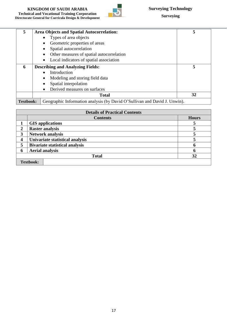
5 Area Objects and Spatial Autocorrelation:
Types of area objects
Geometric properties of areas
Spatial autocorrelation
Other measures of spatial autocorrelation
Local indicators of spatial association
5
6 Describing and Analyzing Fields:
Introduction
Modeling and storing field data
Spatial interpolation
Derived measures on surfaces
5
Total 32
Textbook: Geographic Information analysis (by David O’Sullivan and David J. Unwin).
Details of Practical Contents
Contents Hours
1 GIS applications 5
2 Raster analysis 5
3 Network analysis 5
4 Univariate statistical analysis 5
5 Bivariate statistical analysis 6
6 Aerial analysis 6
Total 32
Textbook:
Page 19
KINGDOM OF SAUDI ARABIA Technical and Vocational Training Corporation
Directorate General for Curricula Design & Development
Surveying Technology
Surveying
18
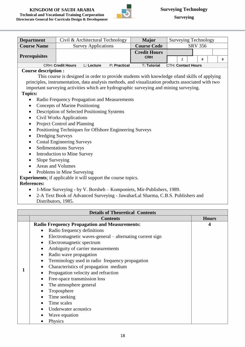
Department Civil & Architectural Technology Major Surveying Technology
Course Name Survey Applications Course Code SRV 356
Prerequisites Credit Hours
CRH 2 CTH 2
L 2 P 0 T 0
CRH: Credit Hours L: Lecture P: Practical T: Tutorial CTH: Contact Hours
Course description :
This course is designed in order to provide students with knowledge ofand skills of applying
principles, instrumentation, data analysis methods, and visualization products associated with two
important surveying activities which are hydrographic surveying and mining surveying.
Topics:
Radio Frequency Propagation and Measurements
Concepts of Marine Positioning
Description of Selected Positioning Systems
Civil Works Applications
Project Control and Planning
Positioning Techniques for Offshore Engineering Surveys
Dredging Surveys
Costal Engineering Surveys
Sedimentations Surveys
Introduction to Mine Survey
Slope Surveying
Areas and Volumes
Problems in Mine Surveying
Experiments: if applicable it will support the course topics.
References:
1-Mine Surveying - by V. Borsheh – Komponiets, Mir-Publishers, 1989.
2-A Text Book of Advanced Surveying - JawaharLal Sharma, C.B.S. Publishers and
Distributors, 1985.
Details of Theoretical Contents
Contents Hours
1
Radio Frequency Propagation and Measurements:
Radio frequency definitions
Electromagnetic waves-general – alternating current sign
Electromagnetic spectrum
Ambiguity of carrier measurements
Radio wave propagation
Terminology used in radio frequency propagation
Characteristics of propagation medium
Propagation velocity and refraction
Free-space transmission loss
The atmosphere general
Troposphere
Time seeking
Time scales
Underwater acoustics
Wave equation
Physics
4
Page 20
KINGDOM OF SAUDI ARABIA Technical and Vocational Training Corporation
Directorate General for Curricula Design & Development
Surveying Technology
Surveying
19
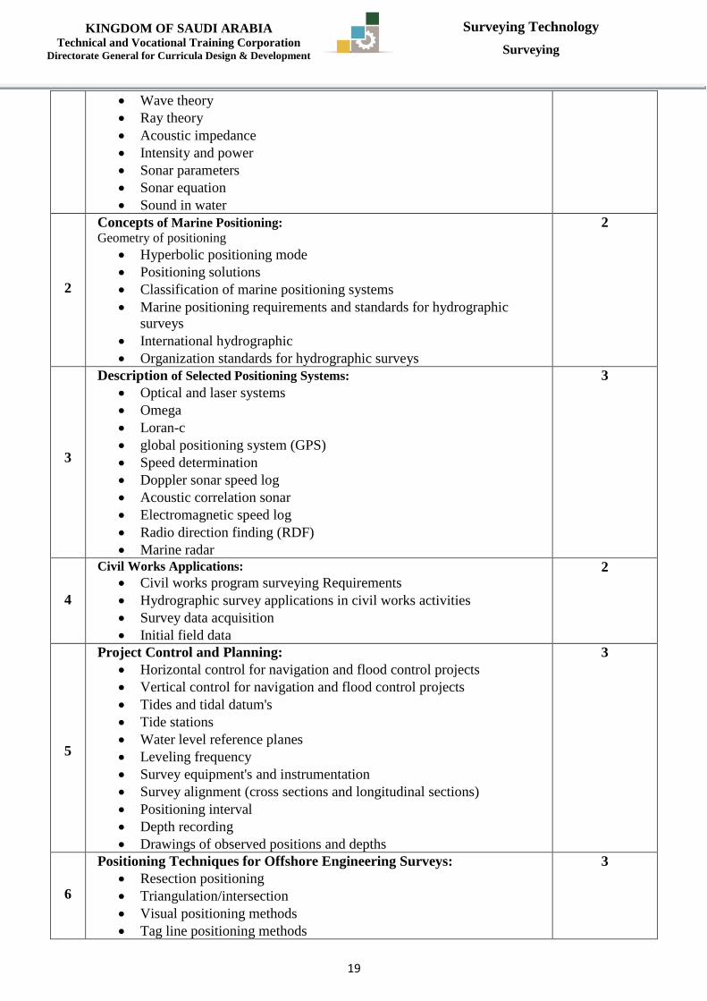
Wave theory
Ray theory
Acoustic impedance
Intensity and power
Sonar parameters
Sonar equation
Sound in water
2
Concepts of Marine Positioning: Geometry of positioning
Hyperbolic positioning mode
Positioning solutions
Classification of marine positioning systems
Marine positioning requirements and standards for hydrographic
surveys
International hydrographic
Organization standards for hydrographic surveys
2
3
Description of Selected Positioning Systems:
Optical and laser systems
Omega
Loran-c
global positioning system (GPS)
Speed determination
Doppler sonar speed log
Acoustic correlation sonar
Electromagnetic speed log
Radio direction finding (RDF)
Marine radar
3
4
Civil Works Applications:
Civil works program surveying Requirements
Hydrographic survey applications in civil works activities
Survey data acquisition
Initial field data
2
5
Project Control and Planning:
Horizontal control for navigation and flood control projects
Vertical control for navigation and flood control projects
Tides and tidal datum's
Tide stations
Water level reference planes
Leveling frequency
Survey equipment's and instrumentation
Survey alignment (cross sections and longitudinal sections)
Positioning interval
Depth recording
Drawings of observed positions and depths
3
6
Positioning Techniques for Offshore Engineering Surveys:
Resection positioning
Triangulation/intersection
Visual positioning methods
Tag line positioning methods
3
Page 21
KINGDOM OF SAUDI ARABIA Technical and Vocational Training Corporation
Directorate General for Curricula Design & Development
Surveying Technology
Surveying
21
Range-azimuth positioning Methods
Land-base electronic positioning method
Global positioning system Techniques
7
Dredging Surveys:
Measurement methods and volume computations techniques
Sea disposal monitoring
Volumes of irregular channels and basins
2
8
Costal Engineering Surveys:
Bed profiling surveys
Time scales-waves-currents-tides-water level changes
Surveying methods and techniques
2
9
Sedimentations Surveys:
Survey techniques
Area capacity computations and curves
2
10
Introduction to Mine Survey:
Role and purposes of Mine Surveying in mineral exploration and
mining.
Difficulties in mine surveying.
General requirements of mine surveying.
Various methods of settings of underground roadways and curves.
Errors in mine surveying: definition, sources, and limits of errors.
Different methods of underground traversing.
Alignment of drives, shafts and gradient control.
3
11
Slope Surveying:
Purpose, objectives, instruments and methods of Slope Surveying.
Selection of Slope Survey.
Survey in moderate inclinations.
2
12
Areas and Volumes:
Measurements of coal stocks and mineral stick piles.
Precautions while measuring large stocks of coal.
2
13
Problems in Mine Surveying:
Dip, strike, faults, cross drift measure problems.
Determination of rate and direction of full dip of seam.
Direction and amount of dip from bore holes.
Modern Survey techniques.
2
Total 32
Textbook:
1-Hydrology, C.D. de jong, G. Lachapelle, S. Skone, I.A. Elema, VSSD ISBN:
9040723591 ISBN13: 9789040723599 DDC: 551, 6th Edition, 2006
2- Mine Surveying - Vol. I, II, III, Ghatak, 5th edition, Coal Field Publishers, 1996.
Page 22
KINGDOM OF SAUDI ARABIA Technical and Vocational Training Corporation
Directorate General for Curricula Design & Development
Surveying Technology
Surveying
21
Department Civil & Architectural Technology Major Surveying Technology
Course Name Spatial Databases Course Code SRV 378
Prerequisites CMT 9325 Credit Hours
CRH 3 CTH 4
L 2 P 2 T 0
CRH: Credit Hours L: Lecture P: Practical T: Tutorial CTH: Contact Hours
Course description :
This course covers basic concepts of a Spatial Database, including understanding what
schemas and views are. Topics will cover also spatial data modeling, query language indexes and
access methods. Topics:
Introduction to Databases
Introduction to Spatial Database
Spatial Operations
Network
Indexes
Query
Experiments: If applicable, it will support the course topics.
References:
Spatial Database Systems: Design, Implementation and Project Management edited by Albert
K. W. Yeung, G. Brent Hall.
Details of Theoretical Contents
Contents Hours
1
Introduction to Databases:
Concept
Database features
Common types of database
Database management system
Types of database architectures: Hierarchical, Network, Relational,
Object-oriented and Deductive.
Relational Model
SQL
Database analysis and design
7
2
Introduction to Spatial Database:
System architecture
Vector spatial data
Spaghetti model
Topology model
5
3
Spatial Operations:
Computing with spatial data
Algorithms
Geometric analysis operations
Relationship analysis
Geometry combination
5
4
Network:
Features
Graphs
Representing graphs
Network operations
5
Page 23
KINGDOM OF SAUDI ARABIA Technical and Vocational Training Corporation
Directorate General for Curricula Design & Development
Surveying Technology
Surveying
22
5
Indexes:
General structure and access method
Spatial indexes
Spatial axes method
Raster structures
Point object structures
Linear objects
Collections of objects
Spherical data structures
5
6
Query:
Query evaluation
Spatial join
Query optimization and execution
5
Total 32
Textbook:
Spatial Databases with application to GIS (by: Philippe Rigaux, Michel Scholl
and Agnes Voisard).
GIS a computing perspective (by: Michael Worboys and Matt Duckham).
Details of Practical Contents
s Contents Hours
1 Part1: SQL 8
2 Part2: Spatial data 8
3 Part3: Spatial analysis 8
4 Part4: Network analysis 8
Total 32
Textbook:
Page 24
KINGDOM OF SAUDI ARABIA Technical and Vocational Training Corporation
Directorate General for Curricula Design & Development
Surveying Technology
Surveying
23
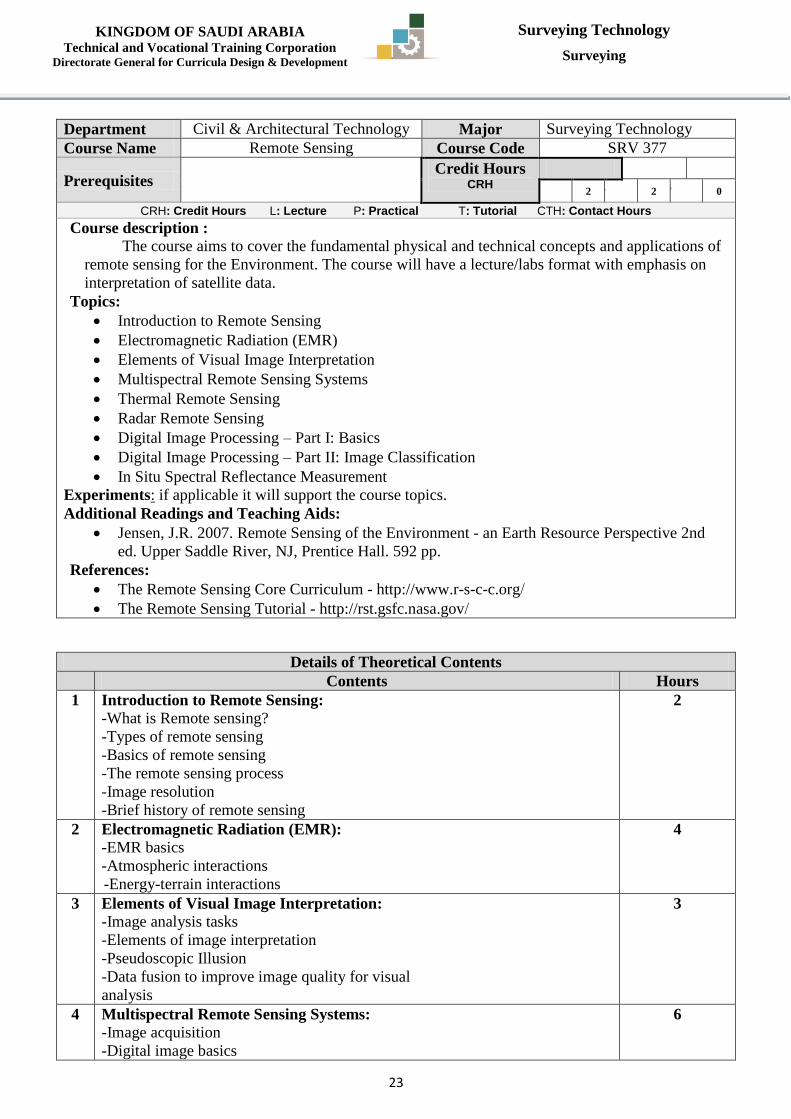
Department Civil & Architectural Technology Major Surveying Technology
Course Name Remote Sensing Course Code SRV 377
Prerequisites Credit Hours
CRH 3 CTH 4
L 2 P 2 T 0
CRH: Credit Hours L: Lecture P: Practical T: Tutorial CTH: Contact Hours
Course description :
The course aims to cover the fundamental physical and technical concepts and applications of
remote sensing for the Environment. The course will have a lecture/labs format with emphasis on
interpretation of satellite data. Topics:
Introduction to Remote Sensing
Electromagnetic Radiation (EMR)
Elements of Visual Image Interpretation
Multispectral Remote Sensing Systems
Thermal Remote Sensing
Radar Remote Sensing
Digital Image Processing – Part I: Basics
Digital Image Processing – Part II: Image Classification
In Situ Spectral Reflectance Measurement
Experiments: if applicable it will support the course topics.
Additional Readings and Teaching Aids:
Jensen, J.R. 2007. Remote Sensing of the Environment - an Earth Resource Perspective 2nd
ed. Upper Saddle River, NJ, Prentice Hall. 592 pp.
References:
The Remote Sensing Core Curriculum - http://www.r-s-c-c.org/
The Remote Sensing Tutorial - http://rst.gsfc.nasa.gov/
Details of Theoretical Contents
Contents Hours
1 Introduction to Remote Sensing:
-What is Remote sensing?
-Types of remote sensing
-Basics of remote sensing
-The remote sensing process
-Image resolution
-Brief history of remote sensing
2
2 Electromagnetic Radiation (EMR):
-EMR basics
-Atmospheric interactions
-Energy-terrain interactions
4
3 Elements of Visual Image Interpretation:
-Image analysis tasks
-Elements of image interpretation
-Pseudoscopic Illusion
-Data fusion to improve image quality for visual
analysis
3
4 Multispectral Remote Sensing Systems:
-Image acquisition
-Digital image basics
6
Page 25
KINGDOM OF SAUDI ARABIA Technical and Vocational Training Corporation
Directorate General for Curricula Design & Development
Surveying Technology
Surveying
24
-Basic multispectral instrument types
-Quantization
-Spatial resolution
5 Thermal Remote Sensing:
-History of thermal remote sensing
-Basics of thermal remote sensing
-Thermal properties of terrain
-Image geometry
-Radiometric calibration
5
6 Radar Remote Sensing:
-Introduction to Radar
-Radar geometry
-Radar resolutions
-Synthetic aperture radar (SAR)
-Radar backscatter
-Polarization
3
7 Digital Image Processing – Part I: Basics
-Visualizing multispectral images
-Band math
-Kauth-Thomas transformation
3
8 Digital Image Processing – Part II: Image
Classification
-Classification methods
-Supervised classification
-Unsupervised classification
-Thematic map accuracy
3
9
In Situ Spectral Reflectance Measurement:
-Measuring spectra in the field
-Assumptions when collecting field spectra
-Field procedures
3
Total 32
Textbook:
The Remote Sensing Core Curriculum - http://www.r-s-c-c.org/
The Remote Sensing Tutorial - http://rst.gsfc.nasa.gov/
Details of Practical Contents
Contents Hours
1 Introduction to ERDAS Imagine and the Basics of Digital Images:
Understand Erdas imagine user-interface
Load and open images
Display the image in pan-chromatic, true color or false color.
Zoom and pan images
View and record the digital number (DN) values of image pixels.
View the reallocation information about the image and individual
pixels.
Enhance image brightness and contrast
Display and use histograms to explore the image statistical properties.
2
2 Gereferencing and Co-Registering an Image:
Collect GCPs.
Use points of known coordinates.
Use previously dereferenced images.
5
Page 26
KINGDOM OF SAUDI ARABIA Technical and Vocational Training Corporation
Directorate General for Curricula Design & Development
Surveying Technology
Surveying
25
3 Interpretation of Satellite Images:
Identify features from space imageries or Google earth based on
fundamental elements of image interpretation.
2
4 Visualizing and Analyzing Multispectral Images:
Collect information about basic properties of major remote sensing
systems using the internet
Explore several different types of remote sensing images to determine
the most useful bands for discriminating certain type of features and to
construct spectral signature curves for different types of geographic
features;
Perform band rationing and finally
Visualize multi-spectral imagery using the RGB color model and HSV
to RGB transformation technique for assisting visual interpretation.
6
5 Thermal Remote Sensing Data:
Visually interpret a daytime Landsat thermal image
Calculate the absolute radiance based on the DN values of thermal
image
Calculate the effective at-satellite temperature;
Smooth the temperature image using a low-pass filter
Visualize the temperature using pseudo color and 3D perspective
views; and
Interpret and compare daytime and nighttime thermal images.
5
6 Interpreting Radar Images:
Interpret a series of radar image chips
Visualize the SAR image
Create a 3D perspective view by draping the SAR image on top of a
Digital Elevation Model
4
7 Image Classification:
Perform supervised classification
Perform unsupervised classification
4
8 Field Spectroscopy:
Collect spectral signatures in the VIS and NIR of common land cover
materials.
Create a spectral library.
4
Total 32
Textbook: ?????????
Page 27
KINGDOM OF SAUDI ARABIA Technical and Vocational Training Corporation
Directorate General for Curricula Design & Development
Surveying Technology
Surveying
26
Department Civil & Architectural Technology Major Surveying Technology
Course Name Digital Photogrammetry Course Code SRV 379
Prerequisites SRV 377 Credit Hours
CRH 3 CTH 4
L 2 P 2 T 0
CRH: Credit Hours L: Lecture P: Practical T: Tutorial CTH: Contact Hours
Course description :
This Course is the second part of photogrammetry topics. This course aims at providing
trainee with essential and basic skills to deal with digital aerial photographs, and digital
photogrammetry systems for drawing digital survey maps form digital aerial stereographs, and
forming digital terrain models (DTMs).
In this course, trainee practices and operates digital photogrammetry computer software and
will use it to perform different photogrammetry operations which includes; inner orientation,
relative orientation, absolute orientation, aerial triangulation, establish digital survey maps, and form
digital terrain models.
Topics:
Introduction to Digital Photogrammetry
Digital Photogrammetry System
Ground Control for Aerial Photogrammetry
Digital Photogrammetry Operations
Aero triangulation
Experiments: if applicable it will support the course topics.
References:
Ackerman, F, "Automatic Aero triangulation". (1995)
Heipke, C," Automation of interior, relative, and absolute orientation". (1997)
Drewniok, C. & Rohr, K," Automatic exterior orientation of aerial images in urban
environment". (1996)
Details of Theoretical Contents
Contents Hours
1 Introduction to Digital Photogrammetry:
Developing digital photogrammetry.
Digital photographs.
Digital aerial Camera.
6
2 Digital Photogrammetry System:
Software.
Hardware.
6
3 Ground Control for Aerial Photogrammetry:
Number and location of control points.
Artificial targets.
4
4
Digital Photogrammetry Operations:
Inner orientation.
Relative orientation.
Absolute orientation.
8
5 Aero triangulation:
Strip formation and adjustment.
Simultaneous Bundle adjustment.
8
Total 32
Textbook: Kasser, M & Egels, W," Digital Photogrammetry". (2002)
Page 28
KINGDOM OF SAUDI ARABIA Technical and Vocational Training Corporation
Directorate General for Curricula Design & Development
Surveying Technology
Surveying
27
Details of Practical Contents
Contents Hours
1 Know How to Operate Digital Photogrammetry Software:
Program setup.
Tools of stereovision.
Program operating routines and their functions.
5
2 Digital Inner Orientation of Aerial Photograph:
Prepare calibration data file.
Prepare digital photographs file of the project area.
Perform digital inner orientation of all photographs.
5
3 Digital Relative Orientation of Aerial Photograph:
Start the program.
Make necessary digital measurements in overlapped areas of digital
photographs.
Perform digital relative orientation to form stereo models, and evaluate
results.
5
4 Digital Absolute Orientation of Aerial Model:
Start the program.
Make necessary digital measurements of control points in digital models
areas.
Perform digital absolute orientation to obtain adjusted models, and
evaluate results.
5
5 Aerial Triangulation to Adjust Block of Models for Drawing Stage:
Start the program.
Make necessary digital measurements of tie points in digital models and
strips areas.
Perform digital aerial triangulation processing to
obtain adjusted block of models, and evaluate results.
6
6 Draw Maps from Adjusted Stereo Models:
Start the program.
Determine limits of drawing area.
Draw features and objects in the predefined
drawing area.
Draw contour lines (form digital elevation model of the predefined
drawing area).
Map revision, and drawing check.
Print map.
6
Total 32
Textbook:
Page 29
KINGDOM OF SAUDI ARABIA Technical and Vocational Training Corporation
Directorate General for Curricula Design & Development
Surveying Technology
Surveying
28
Department Civil & Architectural Technology Major Surveying Technology
Course Name Computer Survey Applications Course Code SRV 485
Prerequisites Credit Hours
CRH 2 CTH 4
L 0 P 4 T 0
CRH: Credit Hours L: Lecture P: Practical T: Tutorial CTH: Contact Hours
Course description :
This course aims at providing trainee chance to practice and gain more skills through
performing some projects using computer programs to draw cadastral and contour maps and print
them with different scales. Also use computer programs to construct longitudinal and cross section
from contour map and extract the cut and fill volumes. Also use computer programs to level piece of
land and compute quantities considering designed level is horizontal and with certain slope.
Topics:
Draw and Print Complete Cadastral Map
Draw and Print Complete Contour Map
Earth Work from Digital Contour Map
Longitudinal and Cross Sections
Experiments: if applicable it will support the course topics.
References :
Auto Cad user manual.
Micro Station user manual.
Available Survey Package user manual.
Details of Practical Contents
Contents Hours
1 Draw and Print Complete Cadastral Map:
Using Layers.
Add texts and legends.
Scale.
Plotting and printing.
14
2 Draw and Print Complete Contour Map:
Using Layers.
Add texts and legends.
Scale
Plotting and printing.
10
3 Earth Work from Digital Contour Map: (case: leveling surface is
horizontal).
Average level.
Predefined level (cut case).
Predefined level ( fill case).
11
4 Earth Work from Digital Contour Map: (case: leveling surface is not
horizontal).
Draw designed surface according to the given Slope.
Define height of cut or fill at designated points.
Compute resulted earth quantities.
11
5 Longitudinal and Cross Sections: (use digital contour map and
available software)
Draw longitudinal section.
Select and draw cross section (cut and fill).
Extract cut and fill quantities according to the designed level.
18
Page 30
KINGDOM OF SAUDI ARABIA Technical and Vocational Training Corporation
Directorate General for Curricula Design & Development
Surveying Technology
Surveying
29
Total 64
Textbook:
AutoCad user manual.
MicroStation user manual.
Available Survey Package user manual.
Page 31
KINGDOM OF SAUDI ARABIA Technical and Vocational Training Corporation
Directorate General for Curricula Design & Development
Surveying Technology
Surveying
31
Department Civil & Architectural Technology Major Surveying Technology
Course Name Highway Engineering Course Code SRV 435
Prerequisites Credit Hours
CRH 3 CTH 4
L 2 P 2 T 0
CRH: Credit Hours L: Lecture P: Practical T: Tutorial CTH: Contact Hours
Course description :
The course is presented in 2 strands. The first strand is concerned with the fundamentals of
highway and pavement engineering. It introduces the design process of roads and intersections,
including horizontal and vertical alignment design, cross-sections and earthworks. The second half
of this strand deals with pavement design and evaluation. Topics include: pavement composition,
pavement materials, asphalt mix design, the pavement thickness design, and defects in Flexible
pavements and failures in Rigid pavements.
The second strand is presents briefly bridges classification and construction methods.
Topics :
History of Road Construction.
Highway Development in Saudi Arabia.
Highway Development Programmers at National Level in Saudi Arabia.
The Highway planning process and principles of route location.
Factors controlling Highway alignment.
Engineering surveys for alignment
Conventional methods and Modern methods (Remote sensing, GIS and GPS techniques)
Geometric design of Highways.
Highways drainage.
Classification, Improvement and Stabilization of soil and Earthworks for Highways.
Sources description properties and uses of bituminous binders.
Asphalt mix design.
Asphalt plants.
Design and construction of different Pavement layers.
Design of rigid Pavements.
Pavement Management.
Types of defects in Flexible Pavements.
Types of Pavement, failures in Rigid Pavements.
Pavement Evaluation.
Introduction to Bridges including (briefly): Bridges classification, bridge types and Bridges
construction methods.
Experiments: if applicable it will support the course topics.
References:
Traffic and Highway Engineering, Fourth Edition, Nicholas J. Garber, Lester A. Hoel,
University of Virginia. 2009, Cengage Learning, 1120 Birchmount Road, Toronto ON M1K
5G4 Canada
O'Flaherty, C.A. (ed) Highways: The Location, Design, Construction and Maintenance of Road
Pavements. Butterworth Heinemann.
Design of Highway Bridges, Authors: Richard Barker & Jay Puckett, Publisher: Wiley
Interscience.
Details of Theoretical Contents
Contents Hours
1 History of Road Construction:
Highway Development in Saudi Arabia.
2
Page 32
KINGDOM OF SAUDI ARABIA Technical and Vocational Training Corporation
Directorate General for Curricula Design & Development
Surveying Technology
Surveying
31
Highway Development Programmers at National Level in Saudi Arabia.
2 The Highway planning process and principles of route location. 2
3 Factors controlling Highway alignment.
Engineering surveys for alignment - Conventional methods and Modern
methods (Remote sensing, GIS and GPS techniques)
3
4 Geometric design of Highways. 4
5 Highways drainage. 2
6 Classification, Improvement and Stabilization of soil and Earthworks for
Highways.
2
7 Sources description properties and uses of bituminous binders.
Asphalt mix design.
Asphalt plants.
6
8 Design and construction of different Pavement layers. 2
9 Design of rigid Pavements.
Pavement Management.
3
10 Types of defects in Flexible Pavements.
Types of Pavement, failures in Rigid Pavements.
Pavement Evaluation.
3
11 Introduction to Bridges including (briefly):
Bridges classification, bridge types and Bridges construction methods.
3
Total 32
Textbook:
Details of Practical Contents
Contents Hours
1 Method for Effect of Heat and Air on a Moving Film of Asphalt 2
2 Asphalt mix design according to Marshal Method. 6
3 Quantitative Extraction of Bitumen From
Bituminous Paving Mixtures.
3
4 Rotational Viscosity. 2
5 Pressure Aging Vessel. 2
6 Dynamic Shear Remoter. 2
7 Bending Beam Remoter. 3
8 Direct Tension test. 3
9 Gyratory Compaction test. 3
10 Asphalt mix design by using E Pave Program (Super paves Method). 6
Total 32
Textbook:
Page 33
KINGDOM OF SAUDI ARABIA Technical and Vocational Training Corporation
Directorate General for Curricula Design & Development
Surveying Technology
Surveying
32
Department Civil & Architectural Technology Major Surveying Technology
Course Name Theory of Errors and Observations
Adjustment Course Code SRV 456
Prerequisites Credit Hours
CRH 3 CTH 5
L 3 P 0 T 2
CRH: Credit Hours L: Lecture P: Practical T: Tutorial CTH: Contact Hours
Course description :
This course is designed for the purpose of examining the nature of measurements, statistical
analysis of random errors in measurements, propagation of errors, survey standards and design
specifications, development of coordinate geometry and trigonometric solutions of plane surveying
problems, analysis of errors and mistakes in indirect measurement. Topics:
Fundamentals of Theory of Errors
Measurements
Observations and Their Analysis
Random Error Theory
Propagation Of Random Errors In Indirectly Measured Quantities
Error Propagation In Angle and Distance Observations
Error Propagation In Traverse Surveys
Error Propagation In Elevation Determination
Weights Of Observations
Principles Of Least Squares
Adjustment Of Level Nets
Adjustment Of Horizontal Surveys- Triangulation
Adjustment Of Horizontal Surveys - Traverses And Networks
Adjustment Of GPS Networks
Coordinate Transformations
Experiments: if applicable it will support the course topics.
References :
ADJUSTMENT COMPUTATIONS: Spatial Data Analysis, CHARLES D. GHILANI and Paul
Wolf, 2010, JOHN WILEY & SONS, INC
Details of Theoretical Contents
Contents Hours
1 Fundamentals of Theory of Errors:
Standard Errors and Weights
o Standard Errors
o Weights and Unit-Weight Standard Error
o Variance-Covariance Matrix and Cofactor Matrix
Error Propagation
o Error Propagation in Linear Functions
o Error Propagation in Non-Linear
Functions
Propagation of Weights
Propagation of Cofactor Matrices
Point Errors
Statistical Analysis
o Probability Distributions
o Confidence Intervals and Error Tolerances
7
Page 34
KINGDOM OF SAUDI ARABIA Technical and Vocational Training Corporation
Directorate General for Curricula Design & Development
Surveying Technology
Surveying
33
o Hypothesis Tests
o Variance Analysis
o Regression Analysis
o Uncertainty in Measurement
o Optimal Estimation
o Least Squares Method
o Minimum Error Variance Estimation
o Matrix Algebra and Numerical Methods
o Numerical Solutions of Linear Equation Systems
2 Measurements:
Direct and Indirect Measurements
Measurement Error Sources
Definitions
Precision versus Accuracy
Redundant Measurements in Surveying and Their Adjustment
Advantages of Least Squares Adjustment
4
3 Observations and Their Analysis:
Sample versus Population
Range and Median
Graphical Representation of Data
Numerical Methods of Describing Data
4
4
Random Error Theory:
Theory of Probability
Properties of the Normal Distribution Curve
Standard Normal Distribution Function
Probability of the Standard Error
o 50% Probable Error
o 95% Probable Error
o Other Percent Probable Errors
o Uses for Percent Errors
Practical Examples
5
5 Propagation Of Random Errors In Indirectly Measured Quantities:
Basic Error Propagation Equation
Frequently Encountered Specific Functions
Standard Deviation of a Sum
Standard Deviation in a Series
Standard Deviation of the Mean
4
6 Error Propagation In Angle and Distance Observations:
Error Sources in Horizontal Angles
Reading Errors
Angles Observed by the Repetition Method
Angles Observed by the Directional Method
Estimated Pointing and Reading Errors with Total Stations
Target Centering Errors
Instrument Centering Errors
Effects of Leveling Errors in Angle Observations
Numerical Example of Combined Error
Propagation in a Single Horizontal Angle
Use of Estimated Errors to Check Angular
Misclosure in a Traverse
7
Page 35
KINGDOM OF SAUDI ARABIA Technical and Vocational Training Corporation
Directorate General for Curricula Design & Development
Surveying Technology
Surveying
34
Errors in Astronomical Observations for an Azimuth
Errors in Electronic Distance Observations
Use of Computational Software
7 Error Propagation In Traverse Surveys:
Derivation of Estimated Error in Latitude and Departure
Derivation of Estimated Standard Errors in Course Azimuths
Computing and Analyzing Polygon Traverse Misclosure Errors
Computing and Analyzing Link Traverse Misclosure Errors
3
8 Error Propagation In Elevation Determination:
Systematic Errors in Differential Leveling
Collimation Error
Earth Curvature and Refraction
Combined Effects of Systematic Errors on Elevation Differences
Instrument Leveling Errors
Rod Plumbing Error
Estimated Errors in Differential Leveling
Error Propagation in Trigonometric Leveling
5
9 Weights Of Observations:
Weighted Mean
Relation between Weights and Standard Errors
Statistics of Weighted Observations
Standard Deviation
Standard Error of Weight and Standard Error of the Weighted Mean
Weights in Angle Observations
Weights in Differential Leveling
5
10 Principles Of Least Squares: Fundamental Principle of Least Squares
Fundamental Principle of Weighted Least Squares
Observation Equations
Formulation of the Normal Equations
Using Matrices to Form the Normal Equations
Least Squares Solution of Nonlinear Systems
Least Squares Fit of Points to a Line or Curve
Fitting Data to a Straight Line
Fitting Data to a Parabola
Calibration of an EDM Instrument
Least Squares Adjustment Using Conditional Equations
Observation Equations
12
11 Adjustment Of Level Nets:
Observation Equations
Unweighted Example
Reference Standard Deviation
Weighted Adjustment
4
12 Adjustment Of Horizontal Surveys- Triangulation:
Azimuth Observation Equation
Linearization of the Azimuth Observation Equation
Angle Observation Equation
Adjustment of Intersections
Adjustment of Resections
6
Page 36
KINGDOM OF SAUDI ARABIA Technical and Vocational Training Corporation
Directorate General for Curricula Design & Development
Surveying Technology
Surveying
35
Adjustment of Triangulated Quadrilaterals
13 Adjustment Of Horizontal Surveys - Traverses And Networks:
Observation Equations
Redundant Equations
Minimum Amount of Control
Adjustment of Networks
4
14 Adjustment Of GPS Networks:
GPS Observations
GPS Errors and the Need for Adjustment
Reference Coordinate Systems for GPS
Converting between the Terrestrial and Geodetic
Coordinate Systems
Application of Least Squares in Processing GPS Data
Network Preadjustment Data Analysis
Analysis of Fixed Baseline Measurements
Analysis of Repeat Baseline Measurements
Least Squares Adjustment of GPS Networks
6
15 Coordinate Transformations:
Two-Dimensional Conformal Coordinate Transformation Equation
Development
Two-Dimensional Affine Coordinate Transformation
Two-Dimensional Projective Coordinate Transformation
Three-Dimensional Conformal Coordinate Transformation
4
Total 80
Textbook: Adjustment computations: spatial data analysis, charles d. Ghilani and paul wolf, 2010,
john wiley & sons, inc.
Page 37
KINGDOM OF SAUDI ARABIA Technical and Vocational Training Corporation
Directorate General for Curricula Design & Development
Surveying Technology
Surveying
36
Department Civil & Architectural Technology Major Surveying Technology
Course Name Geographic Information Systems
(3) Course Code SRV 475
Prerequisites SRV 376 Credit Hours
CRH 3 CTH 4
L 2 P 2 T 0
CRH: Credit Hours L: Lecture P: Practical T: Tutorial CTH: Contact Hours
Course description :
This course will describe new services which become widely distributed through world today
such as Distributed GIS ,Web Mapping ,Location Based Services
Topics:
Distributed GIS : Concepts , Applications
Web Mapping : Introduction , Web mapping supporting technologies , Web mapping services ,
Web mapping applications
Location Based Services: Introduction , Applications , Architectures
Experiments: if applicable it will support the course topics.
References:
Internet GIS: Distributed Geographic Information Services for the Internet ... By Zhong-
RenPeng, Ming-Hsiang Tsou.
Details of Theoretical Contents
Contents Hours
1 Distributed GIS:
Concepts
Applications
6
2 Web Mapping:
Introduction
Web mapping supporting technologies
Web mapping services
Web mapping applications
12
3 Location Based Services:
Introduction
Applications
Architectures
Standards
Interfaces
Privacy
14
Total 32
Textbook: Web GIS: Principles and Applications (by: Pinde Fu and Jiulin Sun)
Details of Practical Contents
Contents Hours
1
Web Mapping:
Introduction
Setting up a WM service
Element of a map
Layout and labeling
16
Page 38
KINGDOM OF SAUDI ARABIA Technical and Vocational Training Corporation
Directorate General for Curricula Design & Development
Surveying Technology
Surveying
37
2
LBS:
Introduction
Development location aware agents
Build a simple agent
Build a simple location based service
Making agents move and detect each other
Privatize the location information
16
Total 32
Textbook:
Page 39
KINGDOM OF SAUDI ARABIA Technical and Vocational Training Corporation
Directorate General for Curricula Design & Development
Surveying Technology
Surveying
38
Department Civil & Architectural Technology Major Surveying Technology
Course Name Project Course Code SRV 495
Prerequisites Credit Hours
CRH 4 CTH 6
L 2 P 4 T 0
CRH: Credit Hours L: Lecture P: Practical T: Tutorial CTH: Contact Hours
Course description :
This course is the first part of applied project. Trainee gets the chance to get knowledge about
executable projects within capacity of trainee. In addition, Trainee reviews some maps and reports
of already executed projects.
Trainee should select a project in coordination with his supervisor. The selected project should
meet some standards such as: allows trainee to apply what he already have of skills and experiences
during his study. In addition, Trainee should be able to use available supplies such as computer labs,
survey systems and software, modern instruments to collect data, process and adjust data, compute
final coordinates and draw maps at required scale.
This course is the second part of applied project. Trainee gets the chance to practice using
most advanced systems to execute projects. In addition, Trainee applies his experiences in carrying
out some engineering and surveying projects.
Trainee should select a project in coordination with his supervisor. The selected project should
meet some standards such as: allows trainee to apply what he already has of skills and experiences
during his study.
Also Trainee should be able to use available supplies such as computer labs, survey systems
and software, modern instruments to collect data, process and adjust data, compute final coordinates
and draw maps at required scale, compute volumes of cut and fill from contour maps an longitudinal
and cross sections, also use available software of Remote sensing, and geographic information
systems, digital photogrammetry. Experiments: If applicable, it will support the course topics.
References:
Instrument manual, program manual, books and material used during training stage.
Details of Contents
Contents Hours
1 First Step:
Preview already executed projects, and suggested projects.
Display some available projects.
Suggesting some idea for new projects.
Reviewing available survey software, hardware, and instruments.
Define the objectives of the project.
Final evaluation requirements regarding presentation of project out comes.
30
2 Second Step:
Carry out project stages.
Set up project plan.
Evaluate and select required instruments and survey systems.
Fieldwork to collect data.
Office work to process data and compute file results.
Draw final map, and prepare final documents.
Present final product for evaluation.
66
Total 96
Textbook: