Page 1 of 11 SRP REQUIREMENTS FOR RESULTS OF SURVEY DOCUMENTS FOR EASEMENT ACQUISITIONS Revision 13 August 01, 2012 This document can be downloaded from: https://www.srpnet.com/about/land/secure/survey/srp_survey_requirements.pdf
Section 04: Performance Concepts 4.1- ROS Documents to be furnished to SRP
4.2- ROS Drawing Document Requirements
4.3- Data to be displayed on the ROS
Section 05: Survey Deliverables
5.1- Reference PLSS corners monuments to the Survey and
to the Central Arizona Coordinate System
5.2- Deliverables
5.2.1 - Paper copy Certificate of Insurance (E&O)
5.2.2 - Paper copy of exhibits, drawings and closure reports
5.2.3 - Digital copy of exhibits, drawings, point listing
Appendices
A) SRP SURVEY contact information
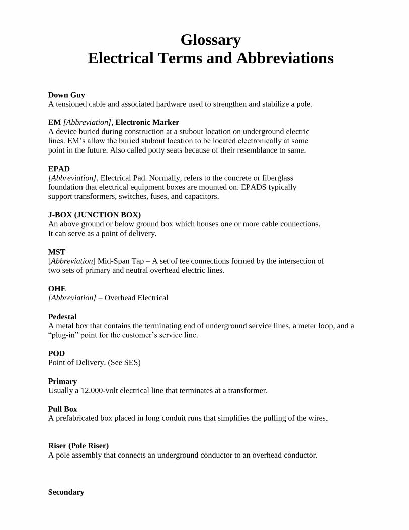
B) Glossary of Electrical Terms
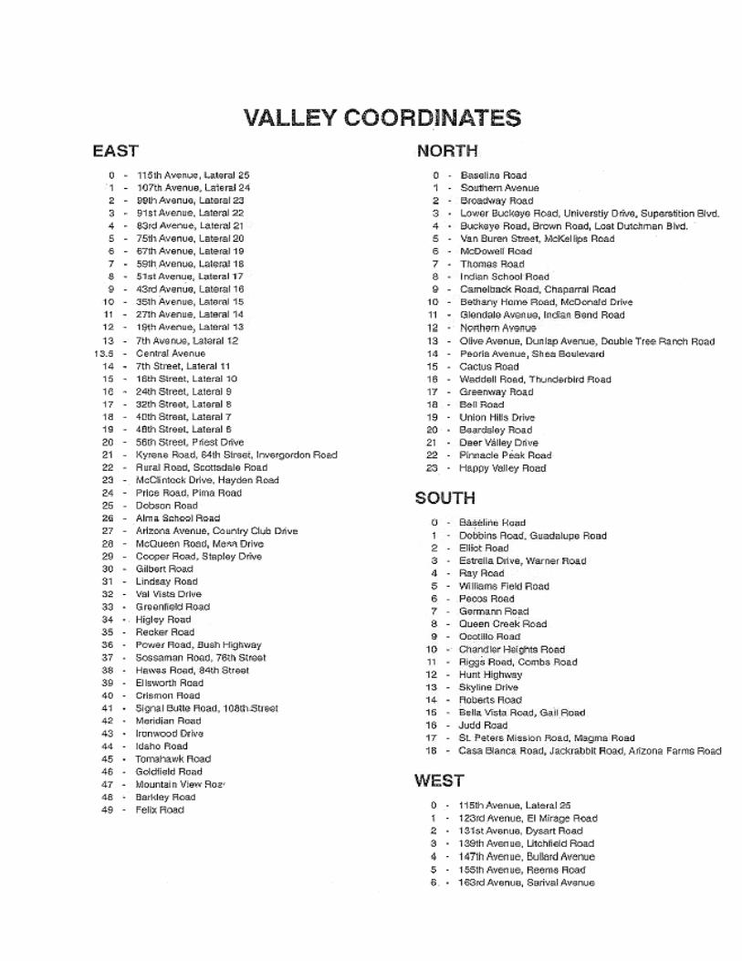
C) SRP Coordinate System and Street Cross Reference
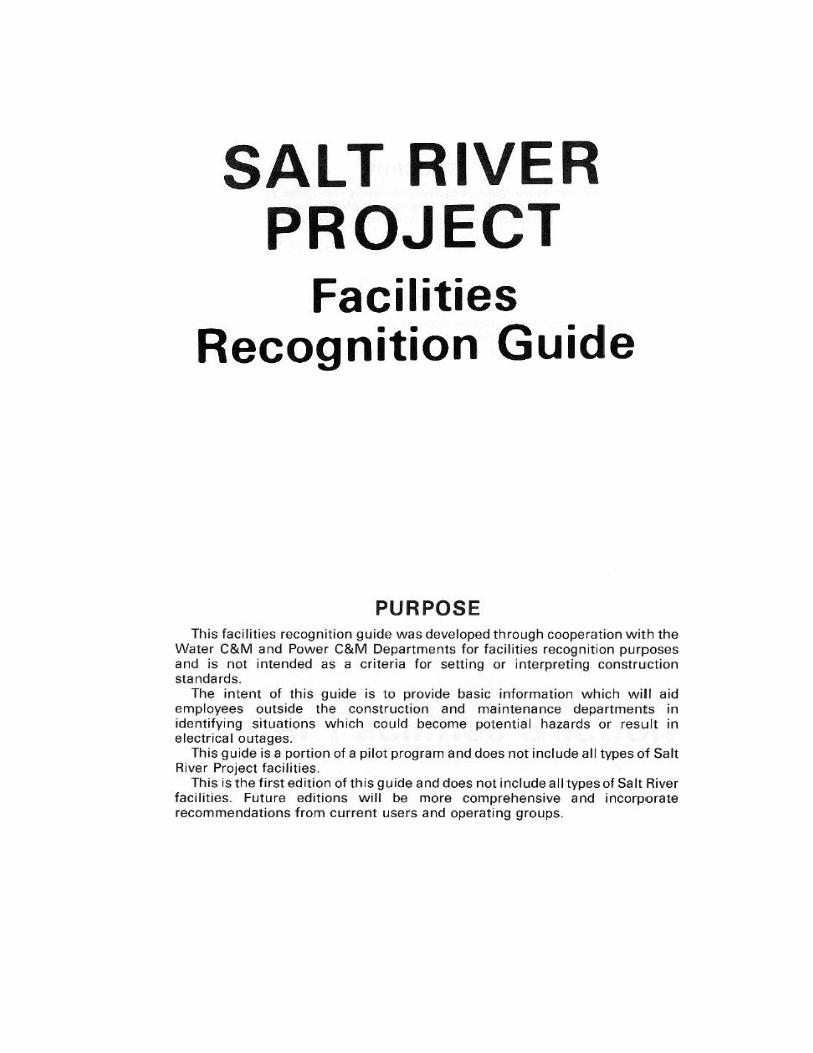
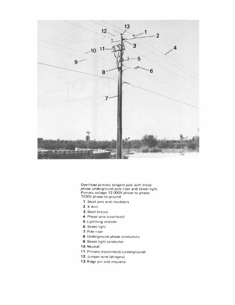
D) SRP Electrical Facilities Recognition Guide
E) E-PAD Quick Reference Card
F) Sample SRP Drawings and exhibits
Page 3 of 11
*** SECTION 01 ***
Section 01:
01: INTRODUCTION
The focus of these requirements is to achieve an optimum degree of uniformity in the professional land survey boundary products and services submitted by SRP Customers, in support of new SRP land right easement acquisitions for power facilities and equipment.
To a high degree, the acceptability of land right acquisitions depends upon properly conducted land boundary surveys. In general, these requirements cover the SRP Land Survey Division policies, requirements, and recommendations that pertain to the appropriate minimum survey procedures.
These requirements are published and provided as an informational standard, to guide professional surveyors tasked with preparing professional survey work products that will be used by SRP for easement acquisition and facility mapping purposes.
These requirements are intended to address the normal conditions encountered on commercial projects and refer to conditions that require professional judgment and interpretations normally exercised by an Arizona Registered Land Surveyor.
These requirements are not intended to be a substitute for professional land boundary surveying knowledge, skills, abilities, experience or judgment. Although portions of these requirements include detailed directions and requirements, they are not an attempt to cover all aspects of land boundary surveying for the easement acquisition process.
It is understood that there may be circumstances and conditions that may make it impossible to comply with some provisions of these requirements. If the responsible professional surveyor must deviate from these requirements then the deviation must be noted, described, and justified by the responsible registered surveyor.
Page 4 of 11
*** SECTION 02 ***
Section 02: 02: OBJECTIVES
These requirements are intended for customers, owners, developers, project managers and professional construction firms (PARTICIPANTS) that elect to utilize their own professional land surveying firms to produce SRP compatible Installation Record Documentation drawings and exhibits for newly constructed SRP electrical distribution facilities, power lines, and equipment. PARTICIPANTS involved in industrial or commercial projects, where the installation of the electric distribution facilities are both extensive and likely to be accomplished in phases lasting days, weeks, or months, stand to benefit from improved project scheduling, by allowing the on-site construction management to coordinate the construction staking and supplying the Results of Survey drawings to SRP.
These requirements support those scenarios where PARTICIPANTS who request the installation of electric power service connections, and have the necessary professional land surveyor resources for supplying the professional documents which display and detail the required installation information, and are capable of supporting the creation and acceptance of the necessary easement acquisition documents within the required timeframe, to expedite the acquisition process.
SRP requires quality drawings since these drawings are intended for the public record, in conjunction with a land rights conveyance for utility purposes. These drawings, in some cases, will be the only record of the location of high-voltage SRP electric distribution facilities on private properties.
PARTICIPANTS shall understand what is required and acceptable under Arizona statute codes and regulatory rules, including the current Arizona Boundary Survey Minimum Standards.
Page 5 of 11
*** SECTION 03 *** Section 03: Qualification of firms and individuals responsible for the
requisite land surveying professional documents.
03.1 Definition of “Firm” The necessary field and office professional land surveying efforts shall be performed and
accomplished by a Firm that is qualified to offer professional land surveying services, as regulated
by the Arizona Board of Technical Registration (AZ/BTR). The current listing of qualified firms
can be found at the AZ/BTR website (http://www.btr.state.az.us/).
Such Firms shall have appropriate and applicable professional surveyors liability insurance (aka,
Errors and Omissions (E&O) Insurance), with a minimum policy requirement of two-hundred and
fifty-thousand dollars ($250,000). Also, the Firm shall have Workers Compensation coverage that
meets all Arizona statutory requirements. It is also suggested that Firms should have the appropriate
Employers‟ Liability and Commercial General Liability, and Auto Liability Insurance with a
combined single limit for bodily injury and property damage of not less than one million dollars
($1,000,000) for each occurrence.
03.1 The Responsible Registrant, Professional Land Surveyor All professional land surveying work and the required deliverables must be performed by, or under
the direct supervision and responsible charge of, an Arizona registered land surveyor, who is also a
principal of the Firm.
All professional land surveyor work and deliverables must comply with all applicable state,
municipal, and county laws, codes, ordinances, and regulatory rules, pertaining to the practice of
professional surveying in Arizona.
In performing the professional land survey assignment, as envisioned and intended by these
requirements, the responsible registrant surveyor shall conduct the land survey engagement in
accordance with the current Arizona Boundary Survey Minimum Standards.
04.1 Results of Survey (ROS) documents to be furnished to SRP.
SRP requires satisfactory ROS drawings that adequately and accurately display the final, installed locations of all new SRP power facilities requiring easements.
Arizona statutory and regulatory requirements direct that these ROS drawings be stamped, sealed, signed and dated by the appropriate professional registrant. The drawings must also meet the prerequisites for recorded survey drawings expressed in:
Arizona Revised Statutes (ARS) Title 11, Article 3, Section 480 (ARS-11-480) and
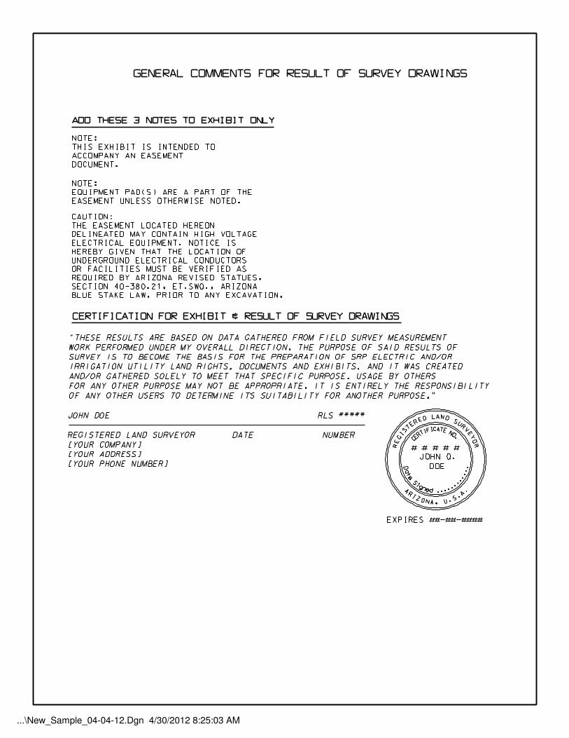
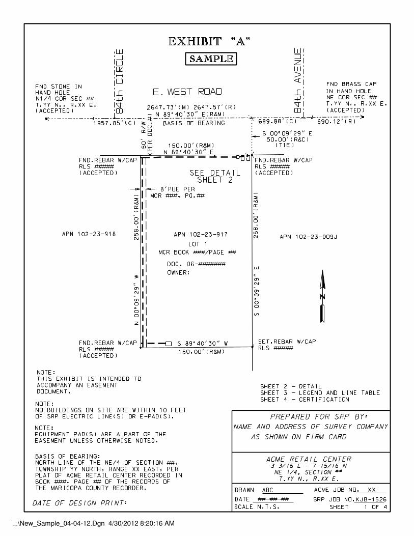
SRP may use the ROS drawings as legal exhibits or use them to create metes and bounds written descriptions. SRP requires that all ROS drawings be developed according to the current Maricopa County Map Recordation Criteria. Professional registrants who submit easement drawings or documents to SRP are ultimately responsible for ensuring compliance with the Arizona Boundary Survey Minimum Standards. A set of sample drawings for a typical job has been included in the appendices of these requirements. The samples includes a Results of Survey drawing, along with a set of exhibit drawings comprised of an index sheet, exhibit drawings, and supporting detailed information.
The Maricopa County Recorder‟s Office (MCRO) sometimes changes its requirements. It is the
duty of the professional land surveyor to be aware of the current MCRO recording requirements
before submitting drawings to SRP. The MCRO recording requirements can be found on
http://recorder.maricopa.gov.
04.2: Conceptual Scope of Work – Performance
Regarding how the PARTICIPANTS‟ responsible registrant, professional surveyor should perform
the necessary field and office survey work to gather and display the requisite information, is within
the concept of „professional judgment‟ as bounded by statutory and regulatory parameters, in
applying the technical knowledge and skill which would be applied by other qualified registrants
who practice the same profession in the same area and at the same time. It is presumed that the work
is performed with diligence and to the normal standards of the industry, including the Arizona
Minimum Standards for Boundary Surveys, and any other applicable standards by governing
jurisdictions.
It is presumed that the PARTICIPANTS‟ on-site construction management-surveyor will have
access to all current internal and external design plans and drawings, and that the surveyor will have
been in charge of the construction control staking to guide the location and layout of various utility
facilities, along with the on-site buildings and structures.
It is presumed that the PARTICIPANTS‟ surveyor is proficient in both construction and R/W
acquisition surveying and in the preparation of drawing documents displaying the configurations of
constructed utility facilities.
The Results of Survey drawing produced by or under the direction of the professional surveyor must
allow another professional surveyor, applying similar knowledge and skills, to verify that the SRP
facilities and other features represented on the drawing correlate to their actual physical locations.
The deliverables will be reviewed for accuracy, legibility, coherence, completeness, interpretability
and conformity to state statutes.
The Results-of-Survey (ROS) Drawings shall include the following:
1. All evidence of control monuments and corner monuments, found or set, shall be shown
and noted to indicate which were found and which were set. All evidence of monuments found beyond the immediate surveyed area ON WHICH THE SURVEY IS DEPENDENT shall be indicated and annotated. Bearings and distances to all primary and secondary electrical facilities, including tie points, must be annotated.
2. All SRP projects impacted by the sectionalized land of the Public Land Survey System
(PLSS) must sufficiently tie the facilities to the closest controlling PLSS line and corner
monuments by bearings and distances. If any SRP facilities fall within any type of a
recorded subdivision, there must be sufficient ties between those facilities and the
controlling lot corners, block corners, subdivision corners, or individual property corners,
by bearing and distance.
3. Show all points where SRP facilities touch or cross parcel or property lines. 4. When an SRP facility nearly parallels a controlling PLSS line, R/W line, or property line, it
shall be clearly shown by dimensioned perpendicular distance (tie) from such line to the facility, as necessary, to indicate the typical separation between the line and the facility.
5. Data necessary to indicate the mathematical dimensions and relationships of all curves
shall be represented by displaying the central angle, the radius, the length of curve, the chord, and the chord bearing for each curve.
6. A bearing base or "Basis of Bearing" shall be indicated and referenced to a well-fixed
bearing line so that the bearings may easily be re-established. Should the bearing base differ from referenced record title bearing, that difference shall be noted. The "North Arrow" shall be referenced to the bearing base.
7. Bearings shall be shown to the nearest second of arc in the form degrees, minutes and
seconds.
8. Distances are shown, in feet, to the nearest hundredth of a foot.
Page 8 of 11
9. BOTH the referenced record(s) and the field surveyed measured (or field calculated)
distances and bearings shall be clearly indicated.
10. Wherever and whenever practicable, the drawing shall be oriented so that NORTH
is at the top of the drawing, and in every case, referenced by a “North Arrow.”
11. The SRP job number, SRP job name, current design revision date, SRP site location
coordinates, the Section, Township and Range where the site is located, and the PARTICIPANT‟s or Firm‟s job number for cross referencing.
12. The name of project survey crew leader person who conducted the field survey along with the completion date of the field survey.
13. The drawing shall be plotted to a suitable scale, with that scale clearly indicated by
a graphic scale, in feet per inch.
14. All reference documentation, (maps, deeds, plats, etc.), whether provided to, or obtained by
the PARTICIPANTS‟ surveyor, from which any survey information and/or locations were
based, (wholly or in part), shall be noted such that documentation can be found either in the
public record or, if not a recorded document, a hard copy shall be submitted with the ROS
to SRP.
04.3 Data to be displayed on the ROS
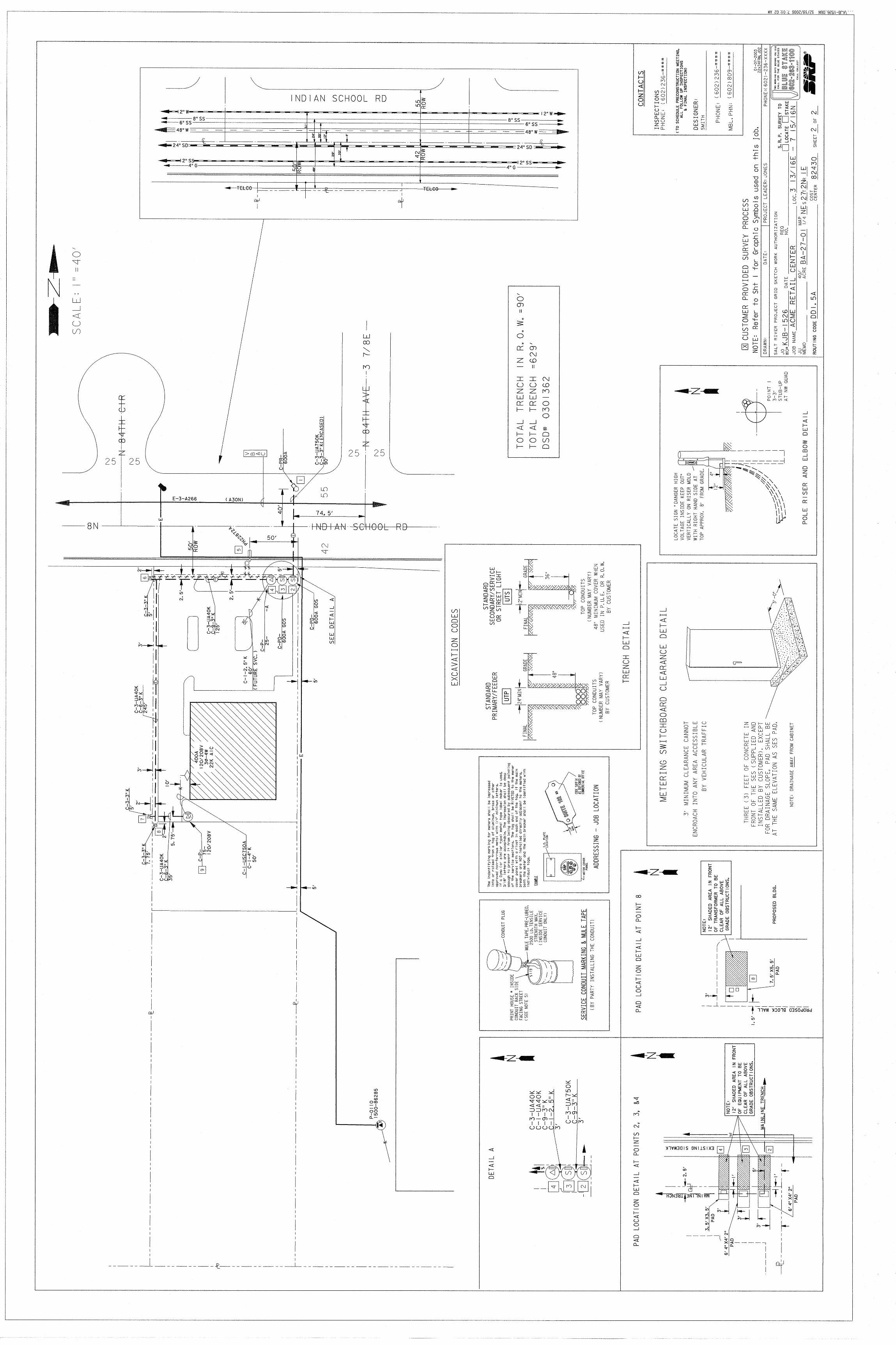
a. All four corners of all newly installed electrical pads.
b. All designed angle points on the newly installed underground electric alignments.
c. Centerlines of all newly installed junction boxes and pull-boxes.
d. Existing SRP overhead electrical and underground electrical facilities, blue stake
markings, splice points, pole risers, electrical manholes, electrical equipment pads and their existing easements, etc. that connect to the newly installed SRP facilities. (See Sample Drawings under Appendices)
e. Building lines within 10 feet of any SRP electric line or equipment pad
Survey Firms are required to provide and maintain a valid Certificate of Insurance (E&O) that meets the specifications identified in Section 03.1 of this document.
05.1.2 PAPER COPIES OF: Original, wet-sealed drawings and exhibits.
RECORDABLE 24” x 36” (Scaled) Results Of Survey Drawings
3 sets of paper media (See Attached Sample Drawing)
RECORDABLE 8 ½ “ x 11” Exhibits (Not to scale)
3 paper copies for SRP (See Attached Sample Exhibits)
BOUNDARY CLOSURE REPORTS Prepared for all parcels affected by new SRP power facilities and equipment.
05.1.3 DIGITAL COPIES OF: CAD files, and Coordinate Listings:
The following digital files shall be delivered to SRP
24” x 36” Result Of Survey drawings in either MicroStation 3D DGN or AutoCad 2006 DWG format
All measured and calculated data points used to produce the results of survey drawing and exhibits should be stored on a single layer or level within the cad file. Those data points should include: recovered survey monuments, sectional and boundary control,
calculated and existing electrical facilities, control points used to calculate electrical facilities, such as existing and proposed structures, wall lines, building lines, curb lines and blue-staked lines, as needed.
8 ½ ” x 11” (Not To Scale) Exhibits delivered in either
MicroStation 3D DGN or AutoCad 2006 DWG format
The responsible RLS registrant will ensure that a graphic representation of his/her
professional seal and signature is contained inside the deliverable CAD file.
A comma separated values (CSV) text file listing the same data points that are stored in the CAD file control layer described above. The CSV file should include the point numbers, northings, eastings, elevations and point descriptions. The column headings should include the unit of measure, datum, and other relevant metadata. The coordinates should be local, ground and should be
accompanied with the appropriate combined scale factor, if available.
Page 10 of 11
5.2 Reference the Public Land Survey System (PLSS) corner monuments on the Results of Survey to the Arizona State Plane Coordinate System
All submitted Results of Survey drawings are required to show the reference bearings and distances to at least two PLSS corner monuments, (section corners and/or quarter corners) of the PLSS section containing the surveyed parcel. This is an Arizona recognized standard, with regards to Arizona Land Boundary Surveys.
PLSS corner monuments, shown on the ROS drawing, shall be labeled with their correct NAD83 coordinate values. Many PLSS monuments have published NAD83 coordinates, as recorded by the Maricopa County Department of Transportation GDACS program.
Land surveyors can freely access the GDACS website at: http://www.mcdot.maricopa.gov/Survey/Gdacs/Gdacs.htm Should GDACS not have any NAD-83 coordinates available for any referenced PLSS corner monument, that fact should be clearly noted on the Results-of-Survey drawing.
When coordinate information is available, it shall be displayed in the Arizona State Plane Grid Coordinate System, zone 202, NAD-83, in units of International Feet, with a precision of two places, right of the decimal.
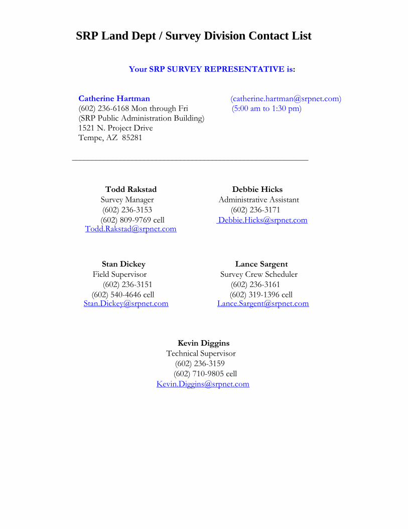
Catherine Hartman ([email protected]) (602) 236-6168 Mon through Fri (5:00 am to 1:30 pm) (SRP Public Administration Building) 1521 N. Project Drive Tempe, AZ 85281
___________________________________________________________ Other SRP Survey Contacts Todd Rakstad Debbie Hicks
Catherine Hartman ([email protected]) (602) 236-6168 Mon through Fri (5:00 am to 1:30 pm) (SRP Public Administration Building) 1521 N. Project Drive Tempe, AZ 85281