Paper No. M-1 DAMAGE DUE TO LIQUEFACTION DURING THE 2011 TOHOKU EARTHQUAKE Shoichi Nakai 1 and Toru Sekiguchi 2 SUMMARY The 2011 Tohoku earthquake caused a devastating damage to the eastern part of Japan. The Tokyo metropolitan area that is located more than 300 km away from its hypocenter suffered from strong ground shaking followed by extensive liquefaction damage along the coastal area. The authors have conducted an exhaustive investigation of damage due to liquefaction in Chiba city immediately after the quake. The resulted damage map has shown an extreme maldistribution. This article describes some of the liquefaction damage and then examines the damage distribution by looking into boring logs, aerial photography and microtremor measurement results. It was found from the study that the extreme maldistribution of liquefaction damage is mainly due to the very complex and varying soil profiles of the reclaimed ground along the coast. INTRODUCTION The 2011 Tohoku earthquake (M W 9.0) that struck the eastern part of Japan on March 11 caused a devastating damage to this area resulting in about 20,000 fatalities. The Tokyo metropolitan area, that is located more than 300 km away from its hypocenter, was no exception. The areas along the Tokyo bay and the Tone river valley have suffered from not only strong shaking but also extensive liquefaction damage due to the main and after shocks (Figure 1). The authors have carried out an exhaustive survey on the damage due to liquefaction in Mihama ward of Chiba city, that is located about 50 km east of Tokyo, immediately after the quake for about ten days. The survey was conducted for all the public roads and most of the parks as well as some of the private properties. This survey revealed that due to liquefaction a huge amount of sand boiling, ground deformation and inclination and subsidence of the buildings were found in almost all areas of Mihama ward, which is entirely a reclaimed ground. Photograph 1 shows some of the typical damage found in this area. Although small sand boiling was found on the main road, narrower streets inside a city block were almost completely covered with sand boiling as thick as 45 cm. One of the interesting phenomena, however, is that there are some no-damage blocks right next to heavily damaged blocks, in other 1 Professor, Chiba University, Chiba, Japan. Email: [email protected]2 Assistant Professor, Chiba University, Chiba, Japan. Email: [email protected]
Transcript
Paper No. M-1
DAMAGE DUE TO LIQUEFACTION
DURING THE 2011 TOHOKU EARTHQUAKE
Shoichi Nakai1 and Toru Sekiguchi
2
SUMMARY The 2011 Tohoku earthquake caused a devastating damage to the eastern part of Japan. The Tokyo
metropolitan area that is located more than 300 km away from its hypocenter suffered from strong
ground shaking followed by extensive liquefaction damage along the coastal area. The authors
have conducted an exhaustive investigation of damage due to liquefaction in Chiba city
immediately after the quake. The resulted damage map has shown an extreme maldistribution.
This article describes some of the liquefaction damage and then examines the damage distribution
by looking into boring logs, aerial photography and microtremor measurement results. It was found
from the study that the extreme maldistribution of liquefaction damage is mainly due to the very
complex and varying soil profiles of the reclaimed ground along the coast.
INTRODUCTION
The 2011 Tohoku earthquake (MW 9.0) that struck the eastern part of Japan on March 11 caused a
devastating damage to this area resulting in about 20,000 fatalities. The Tokyo metropolitan area,
that is located more than 300 km away from its hypocenter, was no exception. The areas along the
Tokyo bay and the Tone river valley have suffered from not only strong shaking but also extensive
liquefaction damage due to the main and after shocks (Figure 1). The authors have carried out an
exhaustive survey on the damage due to liquefaction in Mihama ward of Chiba city, that is located
about 50 km east of Tokyo, immediately after the quake for about ten days. The survey was
conducted for all the public roads and most of the parks as well as some of the private properties.
This survey revealed that due to liquefaction a huge amount of sand boiling, ground deformation
and inclination and subsidence of the buildings were found in almost all areas of Mihama ward,
which is entirely a reclaimed ground. Photograph 1 shows some of the typical damage found in this
area.
Although small sand boiling was found on the main road, narrower streets inside a city block were
almost completely covered with sand boiling as thick as 45 cm. One of the interesting phenomena,
however, is that there are some no-damage blocks right next to heavily damaged blocks, in other
1 Professor, Chiba University, Chiba, Japan. Email: [email protected]
2 Assistant Professor, Chiba University, Chiba, Japan. Email: [email protected]
words, the liquefaction damage map has shown an extreme maldistribution.
The objective of this study is to evaluate the effects of the local site conditions on the liquefaction
damage distribution in Mihama ward of Chiba city due to the 2011 Tohoku earthquake based on the
damage survey immediately after the earthquake, the existing soil investigation data and the soil
exploration conducted after the quake [1].
LIQUEFACTION DAMAGE DISTRIBUTION
Figure 2 shows the map of Mihama ward with the constitution of districts. Mihama ward is located
in the western part of Chiba city along the coast of Tokyo Bay and consists entirely of the reclaimed
ground. It was reclaimed by dredge soil consisting of sand or sandy silt taken from the sea bed of
Tokyo Bay. Reclamation was carried out from the southern part of the ward toward north from
1960s until mid-1980s.
Figure 1 Target area
(a) Residential area (b) Business/industrial area
Photo 1 Typical liquefaction damage in Mihama ward, Chiba city
A huge amount of sand boiling due to soil liquefaction occurred in almost all areas in Mihama ward
during the earthquake. Sand boiling was hardly found on the main road and small sand boiling was
found at the edge of the asphaltic pavement or on the sidewalk of the main road. On the other hand,
some narrower streets inside a city block were almost completely covered with sand boiling as thick
as 45 cm.
The sand which spouted out on the roads was removed by Chuo-Mihama civil engineering office of
Chiba city within one week right after the quake. According to the office, the amount of the
removed sand reached 8,500 m3.
The liquefaction damage distribution was surveyed on public roads in Mihama ward immediately
after the earthquake from March 12 to 20. The target of the survey includes all the public roads,
most of the parks and some of the private properties situated in Mihama ward, which could be
entered at that time. The severity of sand boiling is classified into three levels ; heavy, minor and
none. The case in which the overflow area of sand boiling found in the spot is more than about 1 m
is classified as 'heavy'. The case in which the overflow area is less than about 1 m is classified as
'minor'. The case in which no sand boiling was found is classified as 'none'.
Figure 3 shows the distribution of sand boiling using 100 m square grids together with the locations
of emergency restoration of roads conducted by the Chuo-Mihama civil engineering office. White
grids indicate the areas which could not be entered. Heavy sand boiling and road restoration
locations are densely distributed in the coastal area when compared to the inland area. A number of
spots associated with minor sand boiling are found in the inland area. The districts where
widespread heavy sand boiling was found include Nakase, Hibino, Isobe, Takasu, Takahama and
western part of Shinminato as shown in Figure 3. On the other hand, there are some districts, where
only small sand boiling was found, namely Utase, the area between Isobe and Takahama and the
inland part of Shinminato.
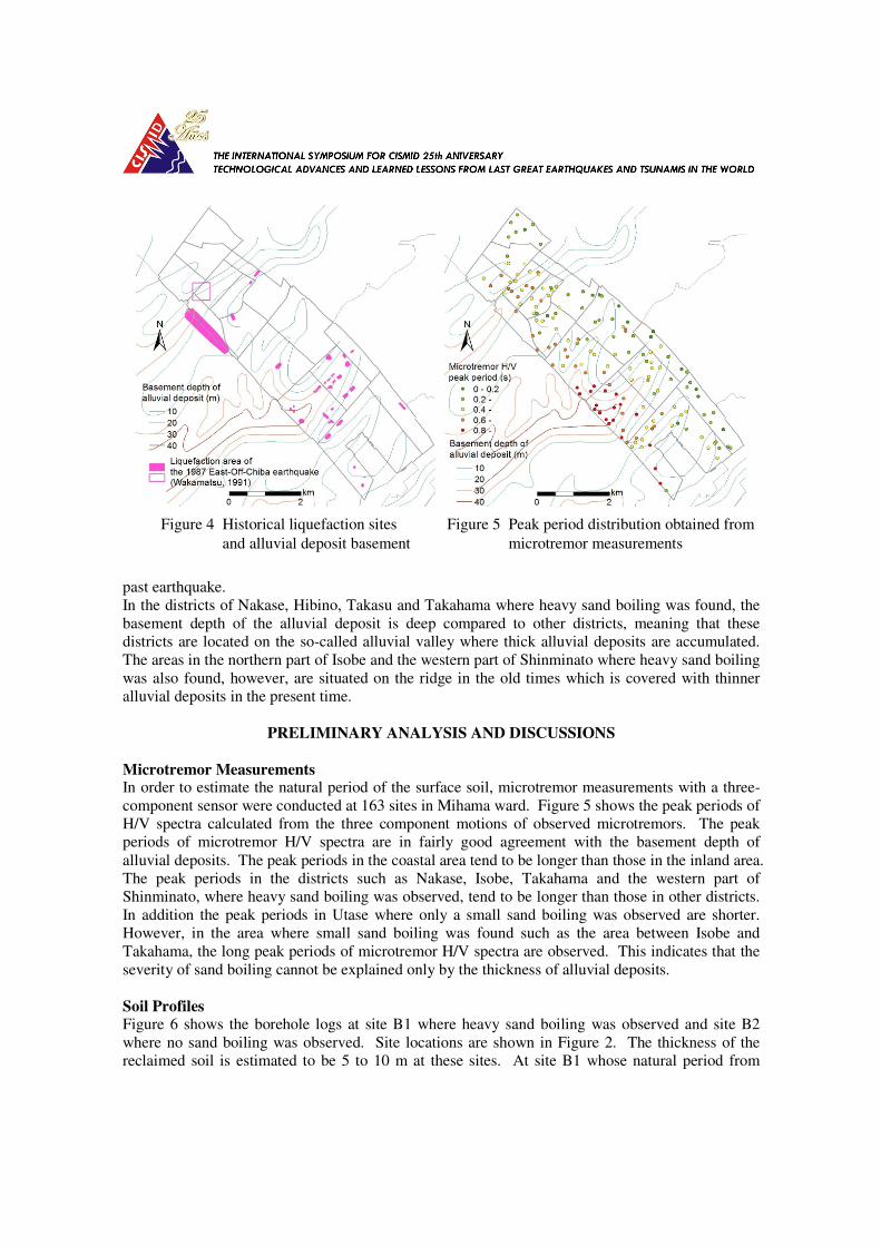
Figure 4 shows the distribution of liquefaction during the 1987 Chibaken-toho-oki earthquake [2] in
addition to contour lines of the basement depth of an alluvial deposit [3]. Most of the past
liquefaction areas are inclusive to the damage area shown in Figure 3. It is also seen from these
figures that the liquefaction damage area of the 2011 earthquake is more widespread than that of the
Figure 2 Map of Mihama ward Figure 3 Distribution of sand boiling
past earthquake.
In the districts of Nakase, Hibino, Takasu and Takahama where heavy sand boiling was found, the
basement depth of the alluvial deposit is deep compared to other districts, meaning that these
districts are located on the so-called alluvial valley where thick alluvial deposits are accumulated.
The areas in the northern part of Isobe and the western part of Shinminato where heavy sand boiling
was also found, however, are situated on the ridge in the old times which is covered with thinner
alluvial deposits in the present time.
PRELIMINARY ANALYSIS AND DISCUSSIONS
Microtremor Measurements In order to estimate the natural period of the surface soil, microtremor measurements with a three-
component sensor were conducted at 163 sites in Mihama ward. Figure 5 shows the peak periods of
H/V spectra calculated from the three component motions of observed microtremors. The peak
periods of microtremor H/V spectra are in fairly good agreement with the basement depth of
alluvial deposits. The peak periods in the coastal area tend to be longer than those in the inland area.
The peak periods in the districts such as Nakase, Isobe, Takahama and the western part of
Shinminato, where heavy sand boiling was observed, tend to be longer than those in other districts.
In addition the peak periods in Utase where only a small sand boiling was observed are shorter.
However, in the area where small sand boiling was found such as the area between Isobe and
Takahama, the long peak periods of microtremor H/V spectra are observed. This indicates that the
severity of sand boiling cannot be explained only by the thickness of alluvial deposits.
Soil Profiles Figure 6 shows the borehole logs at site B1 where heavy sand boiling was observed and site B2
where no sand boiling was observed. Site locations are shown in Figure 2. The thickness of the
reclaimed soil is estimated to be 5 to 10 m at these sites. At site B1 whose natural period from
Figure 4 Historical liquefaction sites Figure 5 Peak period distribution obtained from
and alluvial deposit basement microtremor measurements
microtremor measurements is estimated to be longer compered to other areas, fine sand and silt with
low SPT-N values are found to accumulate alternately. At site B2 whose natural period is also
estimated to be longer, the surface soil, in contrast, consists of fills with N values of about 10 and
silts with low N values with the thickness of 11 m, which is underlain by fine sands with N values
of more than 10. It seems that this is the reason why liquefaction damage is different between the
two sites despite the similar peak periods of microtremor H/V spectra.
A series of cone penetrometer tests (CPT's) were conducted along a line crossing the border
between heavily and less damaged areas in Isobe district as shown in Figure 7 in which the areas
where sand boiling was observed are also shown. Figure 8 shows the estimated profiles of soil
types obtained from CPT loggings at 6 locations. At the locations C1 and C2 near the damaged
area by sand boiling, sand prevails to the depth of about 10 m. At the locations C3, C5 and C6
where no sand boiling was observed, silt and clay are predominant to the depth of 20 m.
Figure 6 Boring logs in Isobe district
Figure 7 CPT locations Figure 8 CPT logs
The above findings and discussions indicate that the difference in type of surface soil as well as the
soil amplification characteristics significantly affected the difference in liquefaction damage in
Mihama ward during the 2011 Tohoku earthquake.
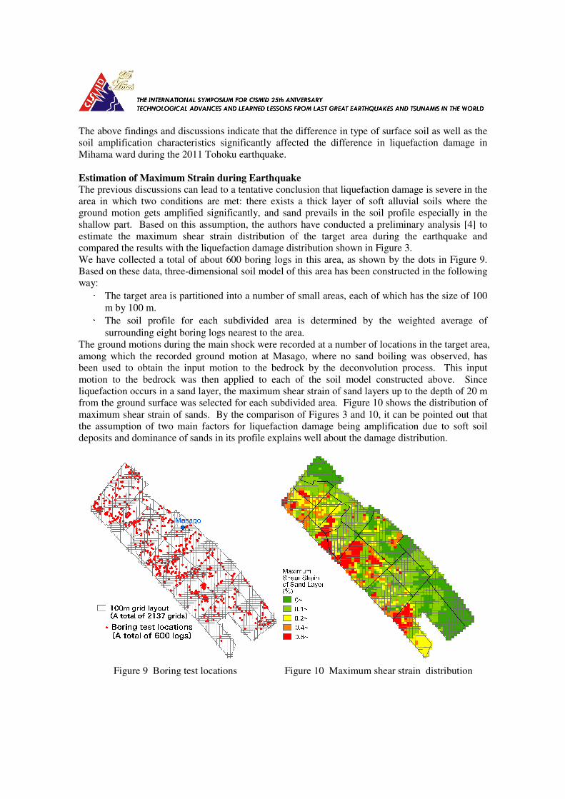
Estimation of Maximum Strain during Earthquake
The previous discussions can lead to a tentative conclusion that liquefaction damage is severe in the
area in which two conditions are met: there exists a thick layer of soft alluvial soils where the
ground motion gets amplified significantly, and sand prevails in the soil profile especially in the
shallow part. Based on this assumption, the authors have conducted a preliminary analysis [4] to
estimate the maximum shear strain distribution of the target area during the earthquake and
compared the results with the liquefaction damage distribution shown in Figure 3.
We have collected a total of about 600 boring logs in this area, as shown by the dots in Figure 9.
Based on these data, three-dimensional soil model of this area has been constructed in the following
way: • The target area is partitioned into a number of small areas, each of which has the size of 100
m by 100 m. • The soil profile for each subdivided area is determined by the weighted average of
surrounding eight boring logs nearest to the area.
The ground motions during the main shock were recorded at a number of locations in the target area,
among which the recorded ground motion at Masago, where no sand boiling was observed, has
been used to obtain the input motion to the bedrock by the deconvolution process. This input
motion to the bedrock was then applied to each of the soil model constructed above. Since
liquefaction occurs in a sand layer, the maximum shear strain of sand layers up to the depth of 20 m
from the ground surface was selected for each subdivided area. Figure 10 shows the distribution of
maximum shear strain of sands. By the comparison of Figures 3 and 10, it can be pointed out that
the assumption of two main factors for liquefaction damage being amplification due to soft soil
deposits and dominance of sands in its profile explains well about the damage distribution.
Figure 9 Boring test locations Figure 10 Maximum shear strain distribution
Effect of Land Reclamation Process The sand pumping process was used for reclaiming the land in Mihama ward [5]. In the process,
the soil consisting of sand and sandy silt accumulated on the sea bed of Tokyo bay was dredged,
transmitted through sand pipes to another sea bottom surrounded by an embankment and then
discharged from outlets. In this process, sand with low fine-grain content accumulates near the
outlets of the sand transmission pipes, and silty sand with high fine-grain content accumulates in the
area which is far from the outlets. In addition, accumulated soils tend to be loose and soft because
of the sedimentary environment. This land reclamation process may explain why the soil profile
varies in a short distance and liquefaction damage shows an extreme maldistribution.
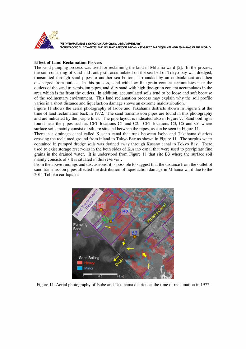
Figure 11 shows the aerial photography of Isobe and Takahama districts shown in Figure 2 at the
time of land reclamation back in 1972. The sand transmission pipes are found in this photography
and are indicated by the purple lines. The pipe layout is indicated also in Figure 7. Sand boiling is
found near the pipes such as CPT locations C1 and C2. CPT locations C3, C5 and C6 where
surface soils mainly consist of silt are situated between the pipes, as can be seen in Figure 11.
There is a drainage canal called Kusano canal that runs between Isobe and Takahama districts
crossing the reclaimed ground from inland to Tokyo Bay as shown in Figure 11. The surplus water
contained in pumped dredge soils was drained away through Kusano canal to Tokyo Bay. There
used to exist storage reservoirs in the both sides of Kusano canal that were used to precipitate fine
grains in the drained water. It is understood from Figure 11 that site B3 where the surface soil
mainly consists of silt is situated in this reservoir.
From the above findings and discussions, it is possible to suggest that the distance from the outlet of
sand transmission pipes affected the distribution of liquefaction damage in Mihama ward due to the
2011 Tohoku earthquake.
Figure 11 Aerial photography of Isobe and Takahama districts at the time of reclamation in 1972
CONCLUSIONS
The distribution of liquefaction damage in Mihama ward of Chiba city during the 2011 Tohoku
earthquake was investigated by conducting an exhaustive search for all the public roads and parks.
The effects of local site conditions on the damage distribution in the region were examined based on
the field survey, microtremor measurements, analysis based on the boring logs and the aerial
photography. From the results and discussions, the following conclusions are made:
1. Liquefaction damage in Mihama ward of Chiba city showed an extreme maldistribution.
2. The soil type of the surface soil as well as its amplification characteristics are the major factors
that affected the severity of liquefaction damage.
3. The variation of soil profiles in a short distance may be resulted from the ground reclamation
process.
ACKNOWLEDGMENTS
The information about the emergency road restoration and land reclamation process was provided
by Chuo-Mihama civil engineering office of Chiba city. The borehole data were provided by Chiba
city and Chiba prefecture.
REFERENCES
1. Sekiguchi, T. and Nakai, S. “Effects of local site conditions on liquefaction damage in Mihama
ward of Chiba city.” Proc. International Symposium on Engineering Lessons Learned from the
2011 Great East Japan Earthquake, 2012: 865-870.
2. Wakamatsu, K. “Maps for historic liquefaction sites in Japan.” 1991. (in Japanese)
3. Kaizuka, S. “The topography, geological feature and water of Tokyo Bay.” Tsukiji Shokan 1993
(in Japanese)
4. Sekiguchi, T., Mori., T. and Nakai, S. "Effects of surface soil amplification characteristics on
liquefaction damage in Mihama ward of Chiba city - Part 2:Evaluation of surface soil
amplification based on borehole data." Proc. 47th Japan National Conference on Geotechnical
Engineering, Paper No.756, 2012: 1503-1504. (in Japanese)
5. Waterfront development department of Chiba city. “Strides of Inage Kaihin newtown.” 1984 (in