27
1 | 27 Danube Reference Data and Services Infrastructure Danube_Net (D1) State-of-play and organisational context of data infrastructure in Serbia Dragica Pajic June 2016

1 | 27
Danube Reference Data and Services Infrastructure
Danube_Net (D1)
State-of-play and organisational context of data
infrastructure in Serbia
Dragica Pajic
June 2016
2 | 27
Contents
1 Introduction .............................................................................................................................. 3
1.1 Scope of the document ..................................................................................................... 3
1.2 The Danube Strategy and the DRDSI project overview ..................................................... 3
1.3 Context of the country ....................................................................................................... 4
2 Data providers ......................................................................................................................... 4
2.1 Analysis of key spatial data providers ............................................................................... 9
3 Policy-making organisations .................................................................................................. 13
3.1 Overview of key organizations related to the Danube Strategy ....................................... 13
3.2 Support for the national data infrastructure ..................................................................... 18
4 Research organisations ......................................................................................................... 20
5 Stakeholder engagement organisations and networks ........................................................... 23
6 Conclusions ........................................................................................................................... 25

3 | 27
1 Introduction
1.1 Scope of the document
This State of play report gives overview of the current development of the geo-sector in Serbia as well describes potential for support to implement the Danube Strategy and consequently contribution to the DRDSI project. The document reports about the main players from public and private sector on the national level relevant to the priority areas of the Danube strategy. The task is to identify data providers, policy-making organisations, research entities and stakeholders supporting the national data infrastructure establishment. Based on analyses of available information and the current status, as conclusion are given main identified obstacles, readiness to contribute to EUSDR and recommendations how to proceed with the key players in order to utilise the available potentials.
1.2 The Danube Strategy and the DRDSI project overview
The EU Strategy for Danube Region (EUSDR) relies on the integrated approach to encourage better policy development and the alignment of funding and resources through concrete actions and projects. The European Commission adopted the Danube Strategy in 2010. The Danube Region covers countries that belong to the Danube River basin: Germany, Austria, Slovakia, Czech Republic, Hungary, Slovenia, Croatia, Serbia, Romania, Bulgaria, Moldova, Ukraine, Bosnia and Herzegovina and Montenegro. Having in mind that the Danube countries face interrelated cross-border issues, the Strategy aims to propose common solutions to challenges in the region. To achieve these, policy-makers need access to clear and comparable information to perform macro-regional analysis.
The Strategy outlines 11 priority areas for project implementation for which coordinating countries have been designated (two for each area):
PA1A Mobility – Waterways
PA1B Mobility – Rail-road-air
PA2 Energy
PA3 Culture & Tourism
PA4 Water Quality
PA5 Environmental Risks
PA6 Biodiversity, landscapes, quality of air and soil
PA7 Knowledge Society
PA8 Competitiveness
PA9 People & Skills
PA10 Institutional capacity and cooperation
PA11 Security
During 2013, The Joint Research Centre (JRC) of the European Commission launched the DRDSI project to develop an infrastructure that will facilitate access to harmonised data sets related to the Danube Region. The DRDSI project was proposed as one of the flagship actions of Priority Area 07 "To develop the Knowledge Society (research, education and ICT)" of the EUSDR. The DRDSI project is part of scientific support to the Danube Strategy taking into account the coherence between various policy priorities. PA7 is coordinated by Slovakia and Serbia.
4 | 27
Objective of the DRDSI project is support of the Danube strategy realisation through contribution to INSPIRE directive implementation in the region focusing on data related to four vertical priorities:
(1) Environment protection (landscape and biodiversity, flood and droughts risks)
(2) Navigability (river morphology, waterways)
(3) Irrigation and agricultural development (soils and crops)
(4) Energy production (available energy resources and energy potential)
The development of the DRDSI follows implementation via three phases:
I A Danube metadata repository is established based on existing data: available JRC data; other relevant EU sources such as EUROSTAT or the European Environment Agency projects.
II The gaps and needs for additional data are identified.
III Inclusion of additional components such as a collaborative platform, a citizen observatory and media.
Besides it, the project aims to maximise benefits from member states investments in INSPIRE implementation through data harmonisation and interoperability efforts. Additionally, the project supports non-EU countries to be compliant with INSPIRE.
The Project is led by Joint Research Centre, Institute for Environment and Sustainability (IES), Digital Earth and Reference Data Unit (DE Unit). Key partners are INSPIRE National Contact points of the Danube Region, university network and public authorities that play role in the scope of the project. The Danube_NET members have been appointed as national representatives from 14 countries from the Danube River basin. Task of Danube_NET members is to proactive contribution to facilitate the engagement of data providers from the Danube region on the national level and facilitate access to this data to help populate the DRDSI platform with good quality content.
1.3 Context of the country
The Republic of Serbia, as a candidate country for EU accession, has recognized chance to participate equally in the process of developing the Danube Strategy and contribute to implementation of the defined objectives. The Danube strategy implementation has sound implication on development of area close to the Danube River as well as wider territory of the Danube basin. 92% of Serbian territory is covered by the Danube basin that makes about 10% of the entire basin. Approximately 90% of water in Serbia originates from outside its territory. Due to it international cooperation on water issues and the other strategic areas is thus vital for Serbia.
By participating in implementation of the Danube Strategy, Serbia faces with great opportunities related to infrastructure development, environmental protection, tourism, transportation, and close cooperation with the Danube Region countries.
The Republic of Serbia, in partnership with the Member States, from the beginning participates in the development of this strategy. Until now, supported Danube’s projects are not isolated actions, but also in the Republic of Serbia there is a systematic way to access the implementation of the Danube Strategy. Also, it is clear that the available funds include projects of national, regional and local importance. For this reason, the successful implementation of the Strategy and the projects that contribute achieving its priorities depends on active participation of all levels of government, but also civil society and the private sector.
2 Data providers
Within the Serbian geo-sector, there are many actors from public sector responsible for production, dissemination and management of spatial data and linked non-spatial data. Besides institutions from public sector, contribution is given by research, academic and private sector.

5 | 27
The key spatial data providers relevant to the EUSDR and DRDSI project scope are listed in the Table 1. The list is not limited only to spatial data covered by the INSPIRE scope, but also it is included data linked closely with implementation of the Danube Strategy. The given list is not exhaustive and presents the most important and active players. In case of complex organisation structure, institution on the top of hierarchy is listed (mostly ministries). Local and regional administration bodies are presented by common name instead of each name individually.
In order to present data on sound and transparent way, spatial data sets are given with INSPIRE theme description.
Table 1: List of data providers
Name of organisation Organisation
type Provided data
Ministry of Construction, Transport and Infrastructure
Public sector Transport networks
Land use
Area management /restriction/ regulation zones and reporting units
Ministry of Mining and Energy Public sector Soil
Geology
Mineral resources
Energy resources
Ministry of Agriculture and Environmental Protection
Public sector Protected sites
Land cover
Utility and governmental services
Environmental monitoring facilities
Agricultural and aquaculture facilities
Area management / restriction / regulation zones and reporting units
Production and industrial facilities
Bio-geographical regions
Habitats and biotopes
Species distribution
Ministry of Public Administration and Local Self-Government
Public sector e-government services
Ministry of Health Public sector Utility and governmental services
Human health and safety
Minister of Education, Science and Technological Development
Public sector Utility and governmental services
Ministry of Economy Public sector Production and industrial facilities
Ministry of Interior Public sector Natural risk zones

6 | 27
Name of organisation Organisation
type Provided data
Republic Geodetic Authority Public sector Coordinate reference systems
Geographical grid systems
Geographical names
Administrative units
Addresses
Cadastral parcels
Elevation
Land cover
Orthoimagery
Statistical units
Buildings
Utility and governmental services
Land use
Basic state map (scale 1:5000)
Topographic data base (scale 1:20000)
Statistical Office of the Republic of Serbia
Public sector Administrative units
Statistical units
Population distribution — demography
Other statistical data
Republic Hydrometeorological Service of Serbia
Public sector Hydrography
Environmental monitoring facilities
Natural risk zones
Atmospheric conditions
Meteorological geographical features
Seismological Survey of Serbia Public sector Natural risk zones
Environmental Protection Agency Public sector Land cover
Environmental monitoring facilities
Production and industrial facilities
Geological Survey of Serbia Public sector Soil
Geology
Natural risk zones
Land use
Mineral resources
Energy resources

7 | 27
Name of organisation Organisation
type Provided data
Institute for Nature Conservation of Serbia
Public sector Protected sites
Bio-geographical regions
Habitats and biotopes
Species distribution
Minister of Agriculture and Environmental Protection
- Directorate for Water
Public sector Hydrography
Geology
Natural risk zones
Public Enterprise „Roads of Serbia“ Public sector Transport networks
Public Enterprise „Serbia Railways“ Public sector Transport networks
Public Enterprise of PTT Communications "Srbija"
Public sector Addresses
Statistical units
Public Water Management Enterprise ‘Serbia Water’
Public sector Hydrography
Agricultural and aquaculture facilities
Natural risk zones
Public Water Management Enterprise ‘Vode Vojvodine’
Public sector Hydrography
Agricultural and aquaculture facilities
Natural risk zones
Public Forest Enterprise ‘Serbia Forest’
Public sector Land cover
Ministry of Construction, Transport and Infrastructure – Directorate for Inland Waterways
Public sector Transport networks
Hydrography
Road Traffic Safety Agency Public sector Transport networks Safe transportation system development Data base for transport safety: http://serbia.gdi.net/azbs
Autonomous Provinces bodies Public sector Transport networks
Hydrography
Protected sites
Agricultural and aquaculture facilities
Area management/restriction/regulation zones and reporting units
Utility and governmental services

8 | 27
Name of organisation Organisation
type Provided data
Local Administration Public sector Transport networks
Hydrography
Protected sites
Utility and governmental services
Area management / restriction / regulation zones and reporting units
Military Geographical Institute Research Geographical names
Orthoimagery
Elevation
Topographic maps (scale 1:25 000; 1:50 000; 1:100 000; 1:200 000; 1:300 000; 1:500 000)
Geographical maps (1: million; 1:5 million scale)
Thematic maps (traffic; hydrography; relief)
Serbian Academy of Sciences and Arts – Geographical Institute “Jovan Cvijic”
Research Geographical maps
Thematic maps (historical, demographic, geomorphologic, economic, agricultural, tourist)
Atlases (speleological …)
Cartographical and graphical appendixes to books (landscape, urban development plans and others)
Monographic
Institute for the Development of Water Resources “Jaroslav Cerni”
Research Hydrography
Natural risk zones
Institute of Architecture and Urban & Spatial Planning of Serbia (IAUS)
Research Area management/restriction/regulation zones and reporting units
Development of spatial and urban plans
Institute of Public Health of Serbia "Dr Milan Jovanovic Batut"
Research Utility and governmental services
Human health and safety
Institute for the Protection of Cultural Monuments of Serbia
http://www.heritage.gov.rs
Research Protected sites
Registers of immovable cultural property
Institute of Veterinary Medicine of Serbia
http://nivs.rs
Research Health protection of animals

9 | 27
Name of organisation Organisation
type Provided data
Faculty of Civil Engineering – Institute of geodesy and geoinformatics,
University of Belgrade
Academic sector
Thematic maps (Land cover, demography, climate …)
BioSense Institute Research Agriculture
Water management
Forestry
Environmental protection
Telekom Serbia Business Utility and governmental services
Contrast Private sector Plan plus – city maps Point of Interest
2.1 Analysis of key spatial data providers
The national geoinformation market may be divided into three main segments:
(1) Public institutions – ministries, special organizations, province and local authorities, public enterprises, research and education entities and other bodies that are financed by the state budget, and require geodata for performing everyday tasks defined by law.
(2) Private enterprises – businesses may need spatial data to support their activities, such as market analysis, localisation etc., and/or businesses that use spatial data to produce value added services for one of the other market segments.
(3) The consumer market – private persons that use spatial data for their own needs.
The geoinformation market in Serbia is not developed in a sufficient way. In most cases data is only available for viewing via web portals.
The initial geoportal GeoSrbija had been launched on in 2009 by support of Norwegian agency for cartography and cadastre Statens kartverk. The geoportal provides online public access for discovery and view services for metadata, spatial datasets and services from the competence of the Republic Geodetic Authority and other public authorities.
Figure 1: Map browser on the geoportal GeoSrbija

10 | 27
Public authorities, local administration, educational and research institutions, private companies and other users daily use the geoportal for the purpose of performing regular work within its competence. In addition, citizens have easy access to geodata via the Internet. Currently, the geoportal is visited over 60 000 users per month. As result, over nine million hits on the Map Browser are reached monthly.
A metadata profile for NSDI purpose for data sets is based on the INSPIRE Implementation rules for metadata, ISO 19115 and ISO 19139. Metadata editor is an application developed for metadata acquisition and maintenance in line with the proposed metadata profile. It creates a valid xml files according to the ISO 19139 standard. Metadata are available for discovery and view via the initial geoportal on the Metadata Browser page [www.geosrbija.rs/rga/rga_metadatabrowser]. Metadata Catalogue Service for enabling proper repository for metadata as well as the central node for launching of discovery service is in the process (the final phase of development).
According to the bilateral agreement between the Republic of Serbia and the Republic of France, the RGA implements the IGIS project “National Spatial Data Infrastructure (NSDI) and Remote Sensing Center for the Republic of Serbia”, through cooperation with French consortium IGN France International and EADS Astrium (now Airbus Defence and Space).
The implemented technical infrastructure comprises flexible, fully scalable and interoperable components well suited for the needs of public authorities and business in Serbia. In doing so, and by using a comprehensive multi-source of data, it enables a variety of spatial data to be produced such as: satellite and aerial imagery; orthophoto satellite mosaics for the national wide coverage; true-orthophoto for the two biggest cities (Belgrade and Novi Sad) and orthophoto for 90 cities; digital elevation models; highly accurate digital terrain model for the flood prone area based on LiDAR acquisition; 3D topographic data base; maps derived by application of remote sensing technologies for environmental, agricultural and risk management purposes etc.
The technical infrastructure for optimised storage and data management allows access to data and services via the web portals. In such a way, smooth data sharing is enabled between public authorities that significantly underpins implementation of the INSPIRE network services in practice.
Figure 2: Satellite imagery before and after the flood (city Obrenovac)
Urgent satellite imagery was acquired for the areas affected by the devastated flood in May 2014 for the western part of Serbia. The supplied imagery is analysed by using remote sensing methodology for obtaining the information on flooded areas, soil saturated by water and potential landslides. Ministries and other public authorities used the imagery with additional mapping data within emergency management to assess the impact and the extent of damages caused by floods. Additionally, Republic Geodetic Authority cooperated with private sector to provide geoinformation

11 | 27
acquired by unmanned aerial vehicles for the most affected sites by floods and landslides. The obtained spatial data on the flooded areas are used for assessment of disaster effects – damages and losses – and impacts as well as the financial requirements to undertake recovery and reconstruction.
Besides the projects where RGA is main beneficiary, there are numerous national cross-sector projects where supply of geoinformation is a core component.
IPA II Action Document 2014 supports flood recovery and prevention foresees development of flood risk and hazards maps for flood prone areas as well as upgrade of the water information system. Flood risk maps are basic elements for the development of Flood Risk Management Plans.
Satisfactory feature of DTMs for flood risk mapping requires recording from the air based on laser technology LiDAR in order to produce DTM with high accuracy and resolution. LiDAR based DTMs allows their use for recording and assessment of damage, reconstruction and revitalization of existing road and railway network, evidence of existing and assessment of new landslides, recovery of open pits, flood and landslide prevention measures, etc.
Flood risk maps are crucial for developing and implementing emergency plans in case of natural disasters, to be always related to accurate hydro-meteorological forecasts based on mathematical modelling. Accordingly with the Floods Directive and the Water Framework Directive requests development of national capacities for accurate forecast on hydro-meteorological events aiming to support agencies operating for the safety of populations and the environment.
Implementing institutions of this component are Water Directorate, RGA, Military Geographical Institute, Public Water Management Company Srbijavode. Public Water Management Company Vojvodina Vode, Republic Hydro-Meteorological Service of Serbia.
Figure 3: DTM for Flood prone area of Tisa River based on LiDAR acquisition
12 | 27
Besides listed project, geoinformation is crucial to underpin implementation of Land Cover Map for NATURA 2000, LPIS project (orthophoto, DTM, cadastral maps), Land Cover map for agriculture in Vojvodina, Rural Land management project – registry of abandoned agricultural land and alike.
On the regional level of the Western Balkan region implementation of the INSPIRE Directive is supported via projects:
The multi-country INSPIRATION - Spatial Data Infrastructure in the Western Balkans project (2012 – 2013), financed by the European Union. The project aims at promoting spatial data infrastructure (SDI) and coordinating its implementation in the Western Balkans with a view to preparing beneficiaries to meet the objectives of the INSPIRE Directive.
On-going the IMPULS project (2014-2018) financed by Swedish International Development Cooperation Agency (SIDA), supports the INSPIRE implementation in the Western Balkan region through settings of the grounds for technical interoperability and dissemination of spatial data and services between public authorities nationally as well as at the regional level.
Geodata and other information are shared on official demand of users. Distribution of geoinformation is mostly done via traditional media (CD/DVD, external hard disks and alike). There is not adopted standard format for data sharing. Exchange of geoinformation via WMS, WFS or WCS services is used between limited numbers of public authorities, but there is an increasing demand for access to data through web services.
Existing policy for access and use of data and services which are provided by public authorities is: Some data are available for free to other governmental bodies; More detailed data are charged according to regulation and price (usually adopted by
government); Data available on web site for public are free of charge.
The actual tendencies in the geoinformation market demand for more available data and free condition for use of data and services based on location in order to reach better cooperation and data reuse. Data sharing is limited due to fragmented data collection, update and dissemination. From the technical perspective, readiness of data providers and users to implement data sharing via standard network services is very heterogeneous. Lack of technical and human capacities for creation and usage of web mapping services results in low level on the available services in practice. However, big step forward is made by introduction of the INSPIRE Directive principles, open data concept and eGovernment strategy.
Republic Geodetic Authority is the leading institution in Serbia for provision of key geodata. The exchange and distribution of geoinformation is performed in accordance with access rights and specified fees defined by regulation. The regulation on fees for use of data of survey and cadastre and related services obtains the price list with condition for use. In some cases data and services are free of charge for certain purposes such as: a report to governmental bodies for processes under their jurisdiction; extract from Real Estate Cadastre for processes initiated as an official task, development of spatial and urban planning and disaster risk management.
Private geodetic organisations perform tasks related to cadastral and topographic survey. Majority of activities are oriented closely to maintenance of Real Estate Cadastre. Some organisation have capacities for execution of projects for land consolidation, large scale topographic maps production for urban planning as well as satellite and aerial imagery provision.
Willingness/readiness to provide users of data with a new data on request is not easy to estimate because of unstable data policy. Based on often changes of regulation, jurisdiction of the ministries and other governmental bodies that causing unstable funding and unpredictable data production strategy. Production cycle for some key data sets is defined by low for certain period (example: national coverage for orthophoto imagery in five years). Long term funding of data acquisition and processing is not in place. So far fundamental data sets are obtain mainly through the international projects (donors, EU funds, the World Bank loan and alike), while clear funding strategy is missing in the state budget allocation.

13 | 27
Considering that Republic Geodetic Authority is, by the nature of its work, the largest producer of key geographic data and that it occupies the position of the main suppliers of geodata in the market, it is required that Republic Geodetic Authority has a leading role in monitoring trends in meeting the needs of modern society for quality and accessible information about the space.
Missing of more open data available for wide public use highly restrict reuse of existing geoinformation. Stable founding of production and dissemination of key spatial data is an essential open issue for unlocking of data for users. Benefits of open data concept is recognised by main players in the national geo-sector mostly thanks to the INSPIRE Directive principles. Awareness on free access to spatial data is arisen on the middle staff level in public authorities because of daily burdens with data sharing, but not enough on the decision maker level. Draft of NSDI Law for full transposition of the INSPIRE Directive envisages long term funding for reference spatial data sets.
The most data relevant the EUSDR scope is under public sector domain as well as followed by research and private sector. From thematic aspect relevant data exists in some digital form. Generally, data are presented in heterogeneous structures without documenting content, quality and access conditions. In practice, it means that interoperability of available data set is difficult to reach. Data exchange is based on access to data in form “as it is” that requires additional work to adapt it to users needs.
Implementation of the INPSIRE Directive is key factor for wider support to DRDSI project and the Danube Strategy. Further application of the INSPIRE data models and network services will highly contribute to favourable technical condition for data exchange and reuse. Especially, data harmonisation is necessary for cross-border applications
3 Policy-making organisations
3.1 Overview of key organizations related to the Danube Strategy
Within the scope of the EUSDR, the Republic of Serbia has been designated to coordinate two priority areas:
Priority Area 1B: To improve mobility and intermodality - rail, road and air transport is coordinated by Slovenia and Serbia. The coordinator is Mr. Miodrag Poledica, State Secretary of the Ministry of Construction, Transport and Infrastructure.
Priority Area 7: To develop the Knowledge Society (research, education and ICT) is coordinated by Slovakia and Serbia. The coordinator is Prof. Dr. Viktor Nedovic, Assistant Minister of Education, Science and Technological Development
In order to ensure timely institutional preparations for active participation in the development and implementation of the Strategy, the Government of the Republic of Serbia adopted a decision on 24 September 2009, to set up a Working Group for Cooperation with the EU in the Danube Region. Members of the Working Group include representatives of the Ministries and institutions relevant for cooperation with the EU in the Danube region, as well as representatives of the Executive Council of Vojvodina and the Serbian Chamber of Commerce and Industry. The main authority in charge of the activities relating to the EU Strategy for the Danube Region in the Republic of Serbia is the European Integration Office. The National Coordinator for Cooperation with the European Union in the Danube Region is Ms. Ana Ilic, Deputy Director of the European Integration Office and Coordinator for EU Funds.
The National Assembly is the supreme representative body and the holder of constitutional and legislative power in the Republic of Serbia. Jurisdiction and scope of work of ministries and special organizations are determined by the Law on Ministries. There are numerous ministries and specialised state organization responsible for different priority areas of EUSDR.
The following table gives an overview of the key policy making players, including responsible policy area and related projects relevant for support to EUSDR.
14 | 27
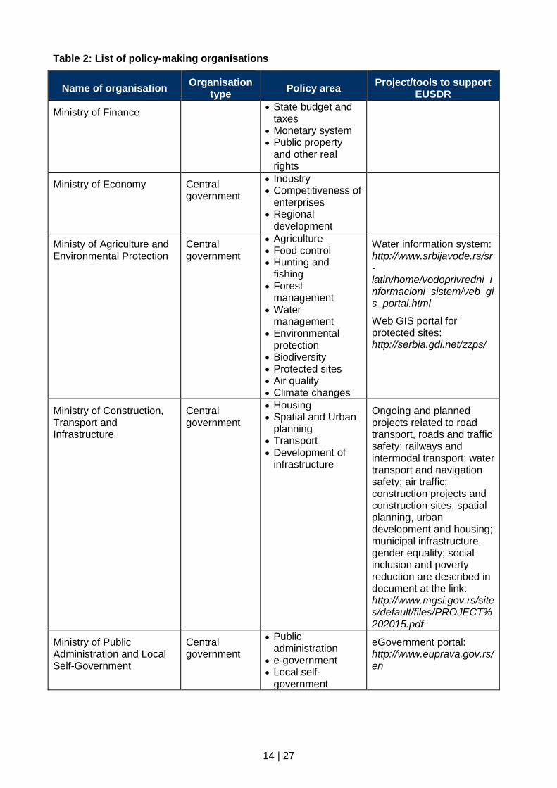
Table 2: List of policy-making organisations
Name of organisation Organisation
type Policy area
Project/tools to support EUSDR
Ministry of Finance State budget and
taxes Monetary system Public property
and other real rights
Ministry of Economy Central government
Industry Competitiveness of
enterprises Regional
development
Ministy of Agriculture and Environmental Protection
Central government
Agriculture Food control Hunting and
fishing Forest
management Water
management Environmental
protection Biodiversity Protected sites Air quality Climate changes
Water information system: http://www.srbijavode.rs/sr-latin/home/vodoprivredni_informacioni_sistem/veb_gis_portal.html
Web GIS portal for protected sites: http://serbia.gdi.net/zzps/
Ministry of Construction, Transport and Infrastructure
Central government
Housing Spatial and Urban
planning Transport Development of
infrastructure
Ongoing and planned projects related to road transport, roads and traffic safety; railways and intermodal transport; water transport and navigation safety; air traffic; construction projects and construction sites, spatial planning, urban development and housing; municipal infrastructure, gender equality; social inclusion and poverty reduction are described in document at the link: http://www.mgsi.gov.rs/sites/default/files/PROJECT%202015.pdf
Ministry of Public Administration and Local Self-Government
Central government
Public administration
e-government Local self-
government
eGovernment portal: http://www.euprava.gov.rs/en

15 | 27
Name of organisation Organisation
type Policy area
Project/tools to support EUSDR
Ministry of Mining and Energy
Central government
Mining Energy resources Natural resources
research
Web GIS portal for geology and mining: http://gis.mre.gov.rs/Srbija/ http://geoliss.mre.gov.rs/
Landslides register BEWARE: http://geoliss.mre.gov.rs/beware/
Open data of the ministry: http://www.mre.gov.rs/otvoreni-podaci.php
Ministry of Trade, Tourism and Telecommunications
Central government
Trade policy Foreign economic
policy Tourism policy Telecommunicatio
n Development of
ICT
e-business development: http://www.eposlovanje.biz/?pismo=latinica
Academic Network of the Republic of Serbia – AMRES: https://www.amres.ac.rs/
Ministry of Justice Central government
Justice and Law Human and
minority rights
EU integration and projects: http://www.mpravde.gov.rs/sekcija/48/evropske-integracije-i-projekti.php
Ministry of Interior Central government
Protection of security
Disaster Risk Response
Register of inhabitants; issuing of travel documents and residency
Sector for emergency: http://prezentacije.mup.gov.rs/svs/
DEWETRA platform: a real-time integrated system for hydro-meteorological and wildfire risk forecasting, monitoring and prevention
The project of cooperation between Serbia and Romania: Joint management of the emergency situations in Romania - Republic of Serbia cross-border area http://en.emsit-borskiokrug.rs/o-projektu.php
Ministry of Foreign Affairs Coordination of
foreign-policy and other international activities
Prepares and keeps the documents relating to the state border
16 | 27
Name of organisation Organisation
type Policy area
Project/tools to support EUSDR
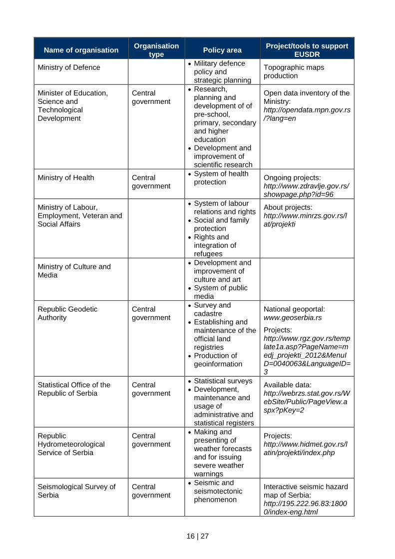
Ministry of Defence Military defence
policy and strategic planning
Topographic maps production
Minister of Education, Science and Technological Development
Central government
Research, planning and development of of pre-school, primary, secondary and higher education
Development and improvement of scientific research
Open data inventory of the Ministry: http://opendata.mpn.gov.rs/?lang=en
Ministry of Health Central government
System of health protection
Ongoing projects: http://www.zdravlje.gov.rs/showpage.php?id=96
Ministry of Labour, Employment, Veteran and Social Affairs
System of labour
relations and rights Social and family
protection Rights and
integration of refugees
About projects: http://www.minrzs.gov.rs/lat/projekti
Ministry of Culture and Media
Development and
improvement of culture and art
System of public media
Republic Geodetic Authority
Central government
Survey and cadastre
Establishing and maintenance of the official land registries
Production of geoinformation
National geoportal: www.geoserbia.rs
Projects: http://www.rgz.gov.rs/template1a.asp?PageName=medj_projekti_2012&MenuID=0040063&LanguageID=3
Statistical Office of the Republic of Serbia
Central government
Statistical surveys Development,
maintenance and usage of administrative and statistical registers
Available data: http://webrzs.stat.gov.rs/WebSite/Public/PageView.aspx?pKey=2
Republic Hydrometeorological Service of Serbia
Central government
Making and presenting of weather forecasts and for issuing severe weather warnings
Projects: http://www.hidmet.gov.rs/latin/projekti/index.php
Seismological Survey of Serbia
Central government
Seismic and seismotectonic phenomenon
Interactive seismic hazard map of Serbia: http://195.222.96.83:18000/index-eng.html
17 | 27
Name of organisation Organisation
type Policy area
Project/tools to support EUSDR
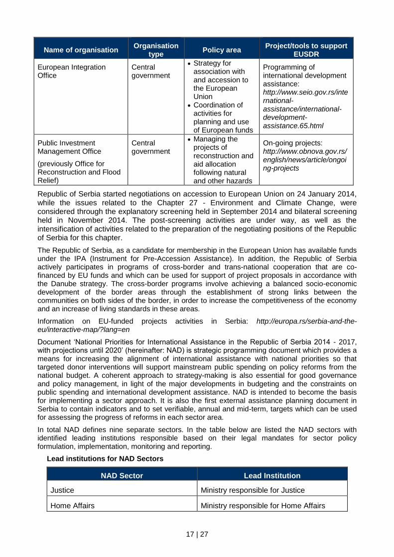
European Integration Office
Central government
Strategy for association with and accession to the European Union
Coordination of activities for planning and use of European funds
Programming of international development assistance: http://www.seio.gov.rs/international-assistance/international-development-assistance.65.html
Public Investment Management Office
(previously Office for Reconstruction and Flood Relief)
Central government
Managing the projects of reconstruction and aid allocation following natural and other hazards
On-going projects: http://www.obnova.gov.rs/english/news/article/ongoing-projects
Republic of Serbia started negotiations on accession to European Union on 24 January 2014, while the issues related to the Chapter 27 - Environment and Climate Change, were considered through the explanatory screening held in September 2014 and bilateral screening held in November 2014. The post-screening activities are under way, as well as the intensification of activities related to the preparation of the negotiating positions of the Republic of Serbia for this chapter.
The Republic of Serbia, as a candidate for membership in the European Union has available funds under the IPA (Instrument for Pre-Accession Assistance). In addition, the Republic of Serbia actively participates in programs of cross-border and trans-national cooperation that are co-financed by EU funds and which can be used for support of project proposals in accordance with the Danube strategy. The cross-border programs involve achieving a balanced socio-economic development of the border areas through the establishment of strong links between the communities on both sides of the border, in order to increase the competitiveness of the economy and an increase of living standards in these areas.
Information on EU-funded projects activities in Serbia: http://europa.rs/serbia-and-the-eu/interactive-map/?lang=en
Document ‘National Priorities for International Assistance in the Republic of Serbia 2014 - 2017, with projections until 2020’ (hereinafter: NAD) is strategic programming document which provides a means for increasing the alignment of international assistance with national priorities so that targeted donor interventions will support mainstream public spending on policy reforms from the national budget. A coherent approach to strategy-making is also essential for good governance and policy management, in light of the major developments in budgeting and the constraints on public spending and international development assistance. NAD is intended to become the basis for implementing a sector approach. It is also the first external assistance planning document in Serbia to contain indicators and to set verifiable, annual and mid-term, targets which can be used for assessing the progress of reforms in each sector area.
In total NAD defines nine separate sectors. In the table below are listed the NAD sectors with identified leading institutions responsible based on their legal mandates for sector policy formulation, implementation, monitoring and reporting.
Lead institutions for NAD Sectors
NAD Sector Lead Institution
Justice Ministry responsible for Justice
Home Affairs Ministry responsible for Home Affairs
18 | 27
NAD Sector Lead Institution
Public Administration Reform Ministry responsible for Public Administration
Competitiveness Ministry responsible for Economy
Energy Ministry responsible for Energy
Transport Ministry responsible for Transport
Human Resource & Social Deveoment Ministry responsible for Employment
Environment & Climate Change Ministry responsible for Environmental Protection
Agriculture & Rural Development Ministry responsible for Agriculture
The lead national (sector) institution is the ministry responsible for coordinating the activities of all relevant institutions related to preparation, implementation and monitoring of sector projects /programmes to be supported by international assistance. The role of the sector lead institution is to guide the efforts within the sector, with the power to make decisions, control resources and coordinate all participating institutions in providing inputs to achieve the desired long and medium-term sector impacts.
Sector Working Groups (SWGs) were established to provide a mechanism for consulting and coordinating the various institutions responsible for the sector management during the programming and monitoring of international assistance. SWGs ensure transparent and inclusive dialogue between all relevant stakeholders around national strategies for each specific sector area and thereby ensure effective participation and coordination of all relevant institutions within a given sector.
NAD focuses on aspects of cooperation within the Western Balkans and macro regions. Besides, the document stresses importance of EUSDR: “The unique status of the Danube River and its hinterland demands international cooperation and coordination, within and outside the EU”.
The Framework Agreement on the Sava River Basin – FASRB, signed on 3rd December 2002, is the first international agreement on the Sava river basin and a reflection of the consensus existing between the signatory States (Bosnia and Herzegovina, Republic of Croatia, Republic of Slovenia and the Republic of Serbia) on the cooperation among them in the establishment of the international navigation regime, sustainable water management and protection from harmful effects of water, water regime and ecosystem.
Relevant links for more information on policy-making players:
http://www.mfa.gov.rs/en/foreign-policy/eu/regional-initiatives/isrbc
http://danube-cooperation.com/
3.2 Support for the national data infrastructure
Establishment of National Spatial Data Infrastructure through implementation of the INSPIRE Directive is mostly driven by the institutions/bodies presented in the following table.
Table 3: Support for the national data infrastructure
Name of organisation Legal act Key initiatives Key funding sources

19 | 27
Name of organisation Legal act Key initiatives Key funding sources
Republic Geodetic Authority
Law on State Survey and Cadastre
INSPIRE implementation
Topographic-mapping production
Cadastral registers
National funding
World Bank loan
EU instruments
Donors funds
Ministry of Public Administration and Local Self-Government
Strategy of Public Administration Reform
Strategy for development of e-government in Serbia 2015 – 2018
Reform of public administration
e-government
National funding
EU instruments
Donors funds
The Law on State Survey and Cadastre adopted in 2009 provides the legal framework for the establishment of NSDI in Serbia, by transposing some provisions of the INSPIRE Directive. The Law defines NSDI through the following provisions: NSDI subjects (stakeholders), establishment, content, metadata, spatial datasets and services, The National Geoportal, constraints, NSDI bodies and competencies of the NSDI Council.
Full transposition will be achieved through a new Law on NSDI. The initial version of the Law on NSDI is drafted as well as discussed on several sessions with stakeholders.
Coordination structure is defined by the Law in order to establish bodies and mechanism for communication with contributors on implementation, such as data and services providers, users, researches and education. According to the Law, the NSDI Council and the working groups are established in 2010 and 2011 respectively.
NSDI Council role of is steering the creation of institutional and technical framework for establishing common geoinformation infrastructure on the national level, through formulation of clear guidelines and resources to achieve this goal. The role of the working groups is operational responsibility for thematic issues for specific areas such as: technical infrastructure, standards, metadata and spatial data, cooperation among stakeholders, legal framework, financing models, research, education, etc.
The Law on Ministries defines the Republic Geodetic Authority (RGA) as a specialized state organization carrying out geodetic technical and administrative tasks defined by the Law. RGA is responsible for establishing and maintenance of the official land registries and production of geoinformation on the national level for purpose of public authorities and citizens such as:
Basic geodetic works (spatial reference systems);
State survey, the state border survey and register;
Real estate cadastre and registration of real estate rights;
Utility cadastre (networks of water supply, sewage and drainage, heating, electric supply, telecommunications, oil and gas distribution);
Register of administrative unites;
Address register;
Topographic-Mapping production (topographic survey and mapping, National Basic Map, orthophoto, DTM, DSM, remote sensing, geographical names registry, cartographic publications);

20 | 27
Real estate valuation and registration;
Geomagnetism and aeronomy;
Geodetic-cadastral information system;
National Spatial Data Infrastructure (NSDI)
RGA is key provider of cadastre, mapping and Earth Observation data in Serbia. Additionally, RGA, as the leading national public authority and contact point for the INSPIRE Directive implementation, has taken many initiates for cooperation and geodata and services sharing among public authorities. Besides, RGA is active member of numerous international organisations related to geodesy and mapping such as EUPOS and EuroGeographic.
The RGA is under the European Union Accession negotiating process in charge of reporting on status of the INSPIRE Directive transposition and implementation within the Chapter 27 – Environment and Climate Changes.
The current national capacities for establishment of NSDI are not sufficient within responsible public authorities. Especially, it is evident need for provision of sufficient and competent human resources considering complexity of the INSPIRE implementation in technical aspect.
There are huge potential of the INSPIRE implementation for provision of harmonised geoinformation aiming to support realisation of goals for the priority areas under the Danube Strategy. The DRDSI platform can actively promote potential of available and unlocked data for benefit of wide range of data users. In order to meet such an objective it is needed to highlight importance of development the sustainable policy framework for data sharing among data producers and users.
4 Research organisations
Within the following table is given overview of key research entities under the scope of work relevant to the Danube Strategy.
Table 4: List of research organisations
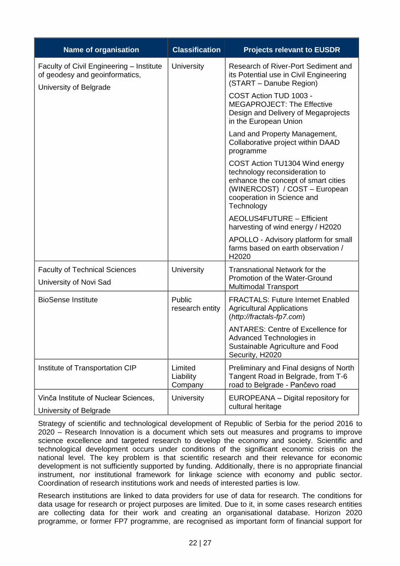
Name of organisation Classification Projects relevant to EUSDR
Serbian Academy of Sciences and Arts – Geographical Institute “Jovan Cvijic”
Public research entity
Geography of Serbia
The Instrumental Spatial Data Collection
Institute for the Development of Water Resources “Jaroslav Cerni”
Public research entity
CC-WARE: Mitigating Vulnerability of Water Resources under Climate Change
DRINKADRIA: Networking for Drinking Water Supply in Adriatic Region
SEE River Project
Institute of Architecture and Urban & Spatial Planning of Serbia (IAUS)
University Sustainable development of the Danube region in Serbia
Spacial, environmental, energy and social aspects of the development of settlements and climate change
Development, spatial planning and use of magistral infrastructure corridor

21 | 27
Name of organisation Classification Projects relevant to EUSDR
Institute of Public Health of Serbia "Dr Milan Jovanovic Batut"
Public research entity
Annual book on health statistic
Institute for Biological Research „Sinisa Stankovic”
Public research entity
EU FP7 TerpMrf - Plant Terpenoids for Human Health: a chemical and genomic approach to identify and produce bioactive compounds
Institute of Veterinary Medicine of Serbia
http://nivs.rs
Public research entity
COST FA1305: The EU Aquaponics Hub: Realising Sustainable Integrated Fish and Vegetable Production for the EU
FAO TCP/RER/3402: Assistance to Western Balkan Countries for Improving Compliance with International Standards for Aquatic Animal Health
EuFMD Pilar I – Improve readiness for FMD crisis management in Member States, Component 1.4, Balkans, to support the development of FMD emergency management capacity in the Balkan region
MediLabSecure Project – Preventing Vector Borne Diseases around the Mediterranean and Black Sea regions by creating new networks
Institute for Science Application in Agriculture
Public research entity
Geological Survey of Serbia Public research entity
Landslides register BEWARE
Institute for Standardization of Serbia Public research entity
22 | 27
Name of organisation Classification Projects relevant to EUSDR
Faculty of Civil Engineering – Institute of geodesy and geoinformatics,
University of Belgrade
University Research of River-Port Sediment and its Potential use in Civil Engineering (START – Danube Region)
COST Action TUD 1003 - MEGAPROJECT: The Effective Design and Delivery of Megaprojects in the European Union
Land and Property Management, Collaborative project within DAAD programme
COST Action TU1304 Wind energy technology reconsideration to enhance the concept of smart cities (WINERCOST) / COST – European cooperation in Science and Technology
AEOLUS4FUTURE – Efficient harvesting of wind energy / H2020
APOLLO - Advisory platform for small farms based on earth observation / H2020
Faculty of Technical Sciences
University of Novi Sad
University Transnational Network for the Promotion of the Water-Ground Multimodal Transport
BioSense Institute Public research entity
FRACTALS: Future Internet Enabled Agricultural Applications (http://fractals-fp7.com)
ANTARES: Centre of Excellence for Advanced Technologies in Sustainable Agriculture and Food Security, H2020
Institute of Transportation CIP Limited Liability Company
Preliminary and Final designs of North Tangent Road in Belgrade, from T-6 road to Belgrade - Pančevo road
Vinča Institute of Nuclear Sciences,
University of Belgrade
University EUROPEANA – Digital repository for cultural heritage
Strategy of scientific and technological development of Republic of Serbia for the period 2016 to 2020 – Research Innovation is a document which sets out measures and programs to improve science excellence and targeted research to develop the economy and society. Scientific and technological development occurs under conditions of the significant economic crisis on the national level. The key problem is that scientific research and their relevance for economic development is not sufficiently supported by funding. Additionally, there is no appropriate financial instrument, nor institutional framework for linkage science with economy and public sector. Coordination of research institutions work and needs of interested parties is low.
Research institutions are linked to data providers for use of data for research. The conditions for data usage for research or project purposes are limited. Due to it, in some cases research entities are collecting data for their work and creating an organisational database. Horizon 2020 programme, or former FP7 programme, are recognised as important form of financial support for

23 | 27
research activities and projects. From the DRDSI objectives perspective, there is potential for cross-border cooperation within the Danube Region in different thematic domains.
5 Stakeholder engagement organisations and networks
In addition to the previously listed actors, there are other entities that play direct or indirect role of coordination and networking including non-governmental organisation, associations and SMEs.
List of stakeholders organisation dealing with geoinformation and closely connected to the Danube Strategy are given in the following table.
Table 5: List of stakeholder engagement organisations
Name of organisation Coverage Area of interest
Standing Conference of Towns and Municipalities
National Meetings, discuss common issues and problems, as well as formulating and presenting the common interests of local authorities
Chamber of Commerce and Industry of Serbia
National Representing the interest of economy to government, other state bodies; international economic cooperation; capacity building and strengthening of competitiveness of domestic economy
Belgrade Chamber of Commerce Regional Representing the interest of economy entities on the territory of City of Belgrade
Serbian Chamber of Engineers National Improvement of the conditions for performance of the professional work in the field of the spatial and city planning, design and construction
Serbian Union of Surveyors National Association of geodetic and geoinformatic experts
National Alliance for Local Economic Development (NALED)
National Association of businesses, local governments and civil society organizations working together on creating better conditions for living and working in Serbia
National Convention on the EU: Platform for participation and monitoring the negotiation process with the EU
National Permanent body for thematically structured debate on Serbian accession into the EU, between representatives of the governmental bodies, political parties, NGOs, experts, syndicates, private sector and representatives of professional organizations
Institute for Protection of Cultural Monuments the City of Belgrade
Regional Protection of cultural monuments, spatial cultural-historical entities, archaeological sites and places of interest in the city of Belgrade

24 | 27
Name of organisation Coverage Area of interest
Danube Area Research Center Regional Scientific research, inter-regional cooperation and education of young people from countries in the Danube region
International Scientific Forum “Danube – River of Cooperation” (ISF”DRC”)
National Interdisciplinary association of experts and researchers devoted to international cooperation in the field of sustainable transport and tourism on the Danube
Central European Development Forum (CEDEF)
National Sustainable energy, renewable energy resources, environmental protection and regional development
International Sava River Basin Commission
International Establishment of an international regime of navigation on the Sava River, sustainable water management, prevent or limit hazards on Sava river
International Commission for the Protection of the Danube River
International Sustainable and equitable use of waters and fresh-water resources in the Danube River Basin
South East Europe Transport Observatory (SEETO)
International Promote cooperation on the development of the main and ancillary infrastructure on the multimodal Indicative Extension of TEN-T Comprehensive Network to the Western Balkans and to enhance local capacity for the implementation of investment programmes as well as data collection and analysis on the Indicative Extension of TEN-T Comprehensive Network to the Western Balkans
EuroGeographics International Association of European National Mapping, Cadastral and Land Registry Authorities.
By providing a single point of contact, the association enables government, business and citizens to benefit from their collective expertise, products and services
Many of the listed organisations acting as an umbrella body for specific domain/area through coordination of relevant activities and projects. Generally, they do not have role to collect some thematic data, but often they need data from public authorities. Due to traditional administrative burdens caused by lack of the flexibility and openness, non-governmental organisations are facing with problem of access to data provided by state administration. Addition to, NGOs do not have capacity for usage of geoinfomation on expert’s level.
For better coordination of stakeholder’s activities on the EUSDR implementation, it is necessary clear profiling as well as creating a single source of information about funding opportunities. It should be highlighted importance of development of mechanisms for cooperation among actors nationally as well internationally.

25 | 27
Listed NGOs and other associations could play important role in promoting of the DRDSI objectives to wider public under their domain of work through sharing of knowledge and good practice to others based on the unlocked data available on the DRDSI platform.
6 Conclusions
The State of Play report provides an overview of the current status, the available data providers and key players relevant for development of the Danube Strategy priority areas with focus on the DRDSI project objectives. Information presented in the report is collected based on direct communication with stakeholders, survey via questioners and accessible information on the relevant web sites.
Generally, it is noted, the readiness of key players to contribute to implementation of the Danube Strategy. Currently, the contribution is not coordinate by a leading institution, but it is mostly project oriented. Duo to it, there is overlapping among project activities caused by lack of communication among organisations and management of the projects. In order to overcome such a situation, communication and sharing of information should be enhanced between the leading institution for coordination of EUSDR and European Integration Office responsible for coordination of EU funds and project programming.
Having in mind that the first phase of the DRDSI projects includes establishment of a Danube metadata repository, appropriate research of the current status of metadata availability is performed. Development of metadata within the Serbian geo-sector is in the initial phase. Certain number of data sets under jurisdiction of Republic Geodetic Authority and several stakeholders are documented in line with standards for metadata in geoinformation area. Metadata is available for search and view on the geoportal GeoSerbia. There is very low level of available WMS services for open data. Usually data are available for download in form of table or shape file and in some cases for view via simple map viewer.
It is evident lack of metadata as description of the existing data sources and web map services. Important driving force for wider use and dissemination of metadata and linked network services is establishment of the metadata catalogue. Thanks to support of the DRDSI project, via the pilot with the Laboratory for development of the open source geospatial technologies (OSGL) at the Faculty of civil-engineering in Belgrade, it established local node for the DRDSI in Serbia to serve metadata for relevant records and services. Geodata created for research purpose through regular activities of the laboratory and other partners are stored on the common repository hosted by the laboratory. Services for view and download with appropriate metadata are created, where CSW service will be used for harvesting from the DRDSI technical platform as local node for open data in Serbia. It should be highlighted that published services are created for unlocked data sets available for re-use of other interested parties. Addition to, Republic Geodetic Authority is under the final phase of development of metadata catalogue for the data sets under their jurisdiction with respective CSW service.
As result of the DRDSI pilot, it is developed a new tool for discovery and view of metadata and linked services. Additionally, the OSGL technical platform is used for creation of WMS services for view of unlocked datasets as well as WFS (for vector data) or WCS (for raster data) services for download. In such a way, the tangible results of the DRDSI project are available for stakeholders and uses. Obviously, it is right approach how to bring benefits of the project closer to users. In this moment, open issue is how to make such a pilot sustainable and to continue with update after accomplishment of the project. Understanding benefits of centralised access to open data could be additional stimulus to populate a new data and services on advantage of data providers and users. Also, it will promote usage of web mapping services (instead of traditional way of data exchange) and reinforce application of open/free GIS tools.
Development of a feasible business model for data provision and favourable terms for data sharing is precondition for achieving sustainable environment for the INSPIRE Directive implementation. In line with of the INSPIRE directive principles, the key factor for the successful establishment of NSDI is applicable terms for cooperation between NSDI stakeholders, with a focus on sustainable
26 | 27
financing of the reference data provision aiming to create terms for application of ‘Open Data’ concept. Such a environment is the key point of the policy framework for direct contribution to the DRDSI project objectives.
On way to reach such a business model, many barriers are identified such as: unstable/unpredictable financing of data provision (very often by the donors projects); obstacles for data sharing (no digital data, data is out of date, incompleteness, restriction for access to data, high prices, and redundancy in data production); geospatial stakeholders do not provide OGC web services for online access to data; lack of GIS capacity in public authorities; gap of information flow of available spatial data and services at the national geo market and alike.
Taking in consideration the listed obstacles, recommended steps and actions will support the DRDSI to meet its potential such as:
Strive for introduction of the appropriate financing policy for data providers from public authorities in order to open access to data
Promotion of the Danube Strategy and the DRDSI platform within the SDI community as integral part of NSDI establishment (to encourage wider community outside of the INSPIRE coverage to contribute and use benefits of DRDSI)
Engagement of stakeholders be motivated to contribute metadata and services
Cross-border cooperation to meet interoperability, data harmonisation and edge-matching as visible show case for a specific thematic domain
Networking of available capacities to spread knowledge and benefits of SDI tools.
Having in mind lack of awareness on benefits of high level decision makers and the current status of NSDI establishment, further development in line with the given recommendation requires sound policy based on top-bottom approach, instead of heterogeneous and not well coordinate up to now.
List of acronyms EU – European Union
EUSDR – EU Strategy for the Danube Region
DRDSI – Danube Reference Data and Services Infrastructure
JRC – Joint Research Centre of the European Commission
INSPIRE – Infrastructure for Spatial Information in Europe
SDI – Spatial Data Infrastructure
NSDI – National Spatial Data Infrastructure
GIS – Geographic Information System
OGC – Open Geospatial Consortium
SME – Small and medium enterprises
NAD – National Priorities for International Assistance in the Republic of Serbia 2014 - 2017, with projections until 2020
IPA – Instrument for Pre-accession Assistance
DTM – Digital Terrain Model
LiDAR –Light Detection and Ranging
OSGL – Laboratory for development of the open source geospatial technologies
WMS – Web Map Service
WFS – Web Feature Service
WCS – Web Coverage Service
CSW – Catalog Service for the Web

27 | 27


