58
DAP Administrator 12.7 Manual

DAP Administrator 12.7Manual

The software described in this manual is furnished under license andmay only be used or copied inaccordance with the terms of the license.
Manual release date: January 17, 2018.
Please send comments or questions to [email protected]
© 2015Geosoft Inc. All rights reserved. Geosoft is a registered trademark andOasis montaj is aregistered trademark of Geosoft Inc. Other brand and product names mentioned herein are properties oftheir respective trademark owners. No part of this publicationmay be reproduced, stored in a retrievalsystem or transmitted, in any form, or by any means, electronic, mechanical, photocopying, reading, orotherwise, without prior consent from Geosoft Inc.
The software described in this manual is furnished under license andmay only be used or copied inaccordance with the terms of the license. DAP.m.2015.06
Windows™, andWindows NT are either registered trademarks or trademarks of Microsoft Corporation.
Geosoft IncorporatedQueen’s Quay Terminal207Queen’s Quay WestSuite 810, POBox 131Toronto, OntarioM5J 1A7CanadaTel: (416) 369-0111Fax: (416) 369-9599Web Site: www.geosoft.comE-mail: [email protected]

www.geosoft.com Geosoft DAP Manual | ii
Table of Contents
Table of Contents ii
Chapter 1: Introduction to Geosoft's DAP Server 1Introduction 1
Technology Overview 1
DAP Server Architecture 2
UserWorkflow 3
Technology Limitations 3
Geosoft DAP Server Licenses 4
Security Extension 4
Esri Integration Extension 4
ESRI Integration - Image Service Extension 4
acQuire Integration Extension 4
ECW Extension 4
Max Datasets 4
Chapter 2: DAP Administrator Settings 5General Information 5
Security 7
Hierarchy 7
StructuredMetadata Query 8
Working with StructuredMetadata Query (Advanced Search) 9
Disclaimers and Stylesheets 9
Dataset Types 10
Dataset Logic 10
View the Spatial Dataset Type Table 11
Adding Document Dataset Types 12
Update Connectors 14
ArcGIS Image Services 14
Utilities 18
UpdateMetadata 18
Lookup Tables 18
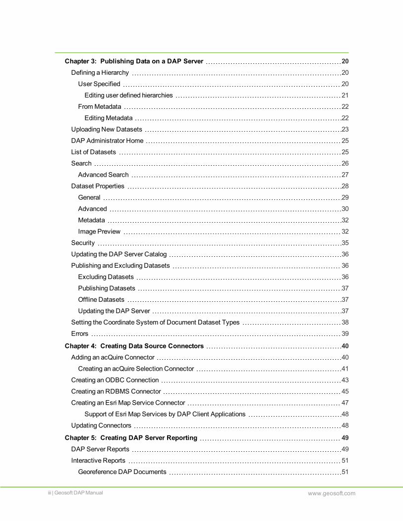
Chapter 3: Publishing Data on a DAP Server 20Defining a Hierarchy 20
User Specified 20
Editing user defined hierarchies 21
FromMetadata 22
EditingMetadata 22
Uploading New Datasets 23
DAP Administrator Home 25
List of Datasets 25
Search 26
Advanced Search 27
Dataset Properties 28
General 29
Advanced 30
Metadata 32
Image Preview 32
Security 35
Updating the DAP Server Catalog 36
Publishing and Excluding Datasets 36
Excluding Datasets 36
Publishing Datasets 37
Offline Datasets 37
Updating the DAP Server 37
Setting the Coordinate System of Document Dataset Types 38
Errors 39
Chapter 4: Creating Data Source Connectors 40Adding an acQuire Connector 40
Creating an acQuire Selection Connector 41
Creating anODBC Connection 43
Creating an RDBMS Connector 45
Creating an Esri Map Service Connector 47
Support of Esri Map Services by DAP Client Applications 48
Updating Connectors 48
Chapter 5: Creating DAP Server Reporting 49DAP Server Reports 49
Interactive Reports 51
Georeference DAP Documents 51
iii | Geosoft DAP Manual www.geosoft.com

Removing Duplicate Datasets 52
Dataset Outputs 52
Creating an Index Map 52
Creating a DAP Administrator Data Package 53
www.geosoft.com Geosoft DAP Manual | iv

Chapter 1: Introduction to Geosoft's DAP Server
IntroductionGeosoft DAP™ (Geosoft Data Access Protocol) is a family of Geosoft server and client services thatenable geoscientists to find spatial and other data for use in their projects. These technologies includethree fundamental components:
Verifying and publishing of all available spatial and other data resources that might be relevant withinan organization. This includes data stored in amanaged file system in themany common formats(grids, images, raw data, and documents), data andmetadata stored in Relational DatabaseManagement Systems (RDBMS), spatial data stored in RDBMS systems (such as acQuire), anddata stored in corporate archiving systems.
Searching for and evaluating data that may be relevant to a project at hand. This involves spatial andcontext searches for data by area of interest, dataset type, and full metadata evaluation to determinethe value of each dataset for a particular use. It also involves quickly previewing the content ofselected datasets.
Retrieval of the selected data, whichmay be windowed to the area of interest, re-projected to anappropriate coordinate system, re-sampled to an appropriate scale, and transformed into a formatthat can be used. This also includes simple retrieval of documents and reports that support the dataand can be viewed in native formats (such as DOC and PDF files).
Technology OverviewThe core component of Geosoft DAP is a server technology that connects networked users to back-endspatial data stores, which is illustrated in the following diagram.

DAP should be installed on a server computer that meets theminimum software and hardwarerequirements provided by Geosoft. The data files are stored in amanaged file system and the associateddata catalog andmetadata are stored in a SQL Server database. DAP responds to requests for datastored in the catalog andmanaged file system. Professionals who need to find and use data will use theirpreferred applications, such as Oasis montaj, ArcMap, or MapInfo. Data can also be browsed andretrieved using a web application. Alternatively, other applications can useGeosoft REST API to deliverdata to their own specific workflows.
DAPServer ArchitectureTheGeosoft DAP Server:
is a web application, and an ISAPI (Internet Server Application Programming Interface) extension
runs on IIS
uses an HTTP REST-like (Representational State Transfer (REST), uses URL –Uniform ResourceIndicator) protocol to communicate with DAP client applications
provides data andmetadata to data consumers
provides the following services:
2 | Geosoft DAP Manual www.geosoft.com
Chapter 1 | DAP Server Architecture

UserWorkflow | Chapter 1
Area of Interest (AOI) andmetadata search
Preview of the data
Security services integrated with Active Directory
Preview and download of metadata
Extraction of data
UserWorkflowThe DAP DataManager may useGeosoft Metadata Editor, Oasis montaj, or ArcMap to review data andperform certain data preparation tasks. A DAP DataManager administers the DAP Server and datacatalog using the DAP Administrator web application through a web browser.
A typical datamanagement workflow might involve accepting a package of project data andmetadata tobe permanently stored in the corporate data centre andmade available to a professional team. The DAPDataManager first verifies that the data quality standards aremet, coordinate systems are correctlydefined, and data formats meet corporate and DAP standards. The approved data is then uploaded to theDAP Server using theMetadata Editor or directly to the Incoming folder, at which time the data is furtherverified and then finally cataloged by the DAP Administrator Portal service. This verification andcataloging process adds the data to the DAP Managed Exploration Information Repository and updatesthe catalog database. The data can then can be published andmade available to all approved users.
Technology LimitationsTheGeosoft DAP technologies are evolving to support more andmore dataset types and environments.
The following important limitations should be understood and accepted before implementing aGeosoftDAP data distribution solution:
Geosoft DAP takes advantage of the wide variety of data formats supported by Geosoft coretechnologies. If one of your data formats is not supported, Geosoft DAP can distribute your data as adocument of unknown type. Processes for georeferencing the data can be established. However, ifdata windowing and data re-projection is required, your datamust be converted to a Geosoft-supported spatial format.
Geosoft DAP technologies are designed for, and tested in, environments that support up to 25concurrent users. Should you require a larger number of concurrent users, Geosoft can work with youto develop usability benchmarks, design data storage, and server scaling strategies tomeet yourrequirements.
Geosoft DAP has been developed usingMicrosoft technologies and is installed and tested onMicrosoft IIS servers. Geosoft DAP cannot be installed on UNIX servers.
Geosoft DAP is intended as a data cataloging and data distribution solution (and potentially withsome data archiving uses). Geosoft DAP can be configured to connect to existing archivingsolutions, but such a configuration should be discussed with Geosoft Professional Services.
www.geosoft.com Geosoft DAP Manual | 3

Geosoft DAPServer LicensesAlong with the basic subscription or license that is required to use the Geosoft’s DAP Server coretechnology, five extensions are available:
Security ExtensionSecurity features include support for Microsoft Active Directory (AD). All data can be secured on adataset-by-dataset basis.
Esri Integration ExtensionThe Esri Integration extension enhances exploration project workflow by enabling the integration of EsriLYR files and ArcGIS Map Services. AnOEM version of ArcGIS Server needs to be installed separatelyand licensed through the DAP Server.
ESRI Integration - Image Service ExtensionThis extension is required to publish raster datasets as an image service using ArcGIS Image ServicesIntegration.
acQuire Integration ExtensionData stored in a corporate acQuire database can be verified and published. acQuire SEL files aresupported for point or hole datasets.
ECW ExtensionThe ECW extension is required to support extraction of ERMapper ECW and JPEG 2000 image fileslarger than 500MB each in size before compression.
Max DatasetsThis extension is required if you will be catalogingmore than 15,000 datasets. A DAP server instancewith this extension supports up to 220,000 datasets
4 | Geosoft DAP Manual www.geosoft.com
Chapter 1 | Geosoft DAP Server Licenses

Chapter 2: DAP Administrator Settings
DAP Administrator is a web application and aWindows service used tomanage and administer yourDAP Server and data catalog.
The DAP Administration web application is written in Python, using the django framework, and runson Apache (not IIS, although special IIS implementations have beenmade). Apache, Python anddjango are installed as part of the DAP Administration Service installation process.
TheGeosoft DAP Administration Service is aWindows service that is responsible for a couple ofactions. It starts the Apache web server and accesses required Geosoft underlying technologies. Italso starts the processes that are responsible for data verification and cataloging.
After successfully installing the DAP Administrator web application and service, certain steps must betaken to prepare the DAP Server for active use. Each DAP Server managed by DAP Administratorrequires its own configuration.
1. Log in to the DAP Administrator web application.
2. Click onSettings.
Most Settings aremodified during implementation. Some Settings may bemodified later on, as required.
Settings are grouped into the following categories:
General Information
Security
Hierarchy
StructuredMetadata Query
Disclaimers and Stylesheets
Dataset Types
ArcGIS Image Services
Utilities
Lookup Tables
These settings are described below.
General InformationThese settings can bemodified and updated as required by the DAP DataManager.
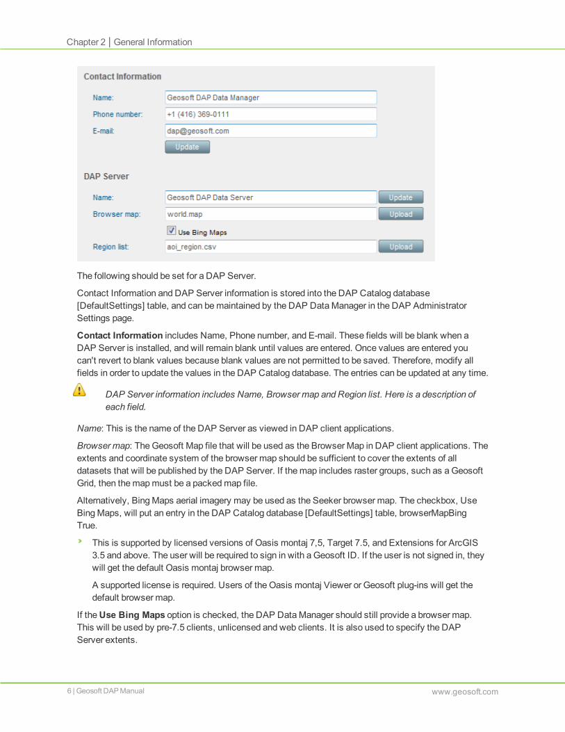
The following should be set for a DAP Server.
Contact Information and DAP Server information is stored into the DAP Catalog database[DefaultSettings] table, and can bemaintained by the DAP DataManager in the DAP AdministratorSettings page.
Contact Information includes Name, Phone number, and E-mail. These fields will be blank when aDAP Server is installed, and will remain blank until values are entered. Once values are entered youcan't revert to blank values because blank values are not permitted to be saved. Therefore, modify allfields in order to update the values in the DAP Catalog database. The entries can be updated at any time.
DAP Server information includes Name, Browser map and Region list. Here is a description ofeach field.
Name: This is the name of the DAP Server as viewed in DAP client applications.
Browser map: TheGeosoft Map file that will be used as the Browser Map in DAP client applications. Theextents and coordinate system of the browser map should be sufficient to cover the extents of alldatasets that will be published by the DAP Server. If themap includes raster groups, such as aGeosoftGrid, then themapmust be a packedmap file.
Alternatively, BingMaps aerial imagery may be used as the Seeker browser map. The checkbox, UseBingMaps, will put an entry in the DAP Catalog database [DefaultSettings] table, browserMapBingTrue.
This is supported by licensed versions of Oasis montaj 7,5, Target 7.5, and Extensions for ArcGIS3.5 and above. The user will be required to sign in with a Geosoft ID. If the user is not signed in, theywill get the default Oasis montaj browser map.
A supported license is required. Users of the Oasis montaj Viewer or Geosoft plug-ins will get thedefault browser map.
If theUse Bing Maps option is checked, the DAP DataManager should still provide a browser map.This will be used by pre-7.5 clients, unlicensed and web clients. It is also used to specify the DAPServer extents.
6 | Geosoft DAP Manual www.geosoft.com
Chapter 2 | General Information

Security | Chapter 2
This feature has the same requirements as Oasis montaj. A high-speed internet connection is ideal, butnot required. There is no browser requirement in Seeker except for the requirements for viewingmetadata.
Region list: The Region List is displayed in DAP client applications. It is loaded from aCSV file andstored in the [DefaultSettings] table in the DAP Catalog database. The aoi_region.csv that may beobserved in theManaged Exploration Information Repository is a cached output from the aoi[RegionList] table in the database. This cache is regenerated every time the DAP Server is started. Youcan add a region in the table directly instead of reloading the CSV, if desired.
SecurityThe Security tab will appear if the DAP Server is licensed for this extension.
User verification: If selected, this optionmeans that user login credentials are used for Seeker to accessthe DAP Server. Flamingo users will be required to enter their Active Directory name and password.
Security groups: The DAP DataManager can create DAP Security Groups and include Active Directorygroups or users. These security groups can be applied to single or multiple datasets. The Userverification checkbox must be selected to activate dataset security.
Default DAP Security Group: The DAP DataManager can select one group to be the default securitygroup. This group will be automatically assigned extract permissions to all new datasets that areuploaded to the DAP Server. By default, no security groups are applied to new datasets on upload. If nogroup is selected as the default then no users will have permission to the datasets. Security will have tobemanually applied to permit access.
If the default security group is modified, the changes will be applied to all datasets with this setting.
See the "DAP Security Model" Technical Note onGeosoft's website for more details.
HierarchyThe term Hierarchy refers to the virtual folders used to display datasets in a dataset tree view in a DAPclient application. These virtual folders can be defined on individual or groups of datasets in the DatasetProperties.
The folder hierarchy can be defined using two different methods:
www.geosoft.com Geosoft DAP Manual | 7

Frommetadata: The folder structure presented in the DAP client application is created frommetadatafields that have been added to the StructuredMetadata Query settings.
User specified: The folder structure presented in the DAP client application is created from the foldersused in the uploading of the data, from theMetadata Editor upload process, or in the dataset propertiesoptions. The folder level may be renamed to somethingmore descriptive.
During the implementation process, the hierarchy is set to use either "Frommetadata" or "Userspecified". Extreme care should be taken when considering switching between these two options.
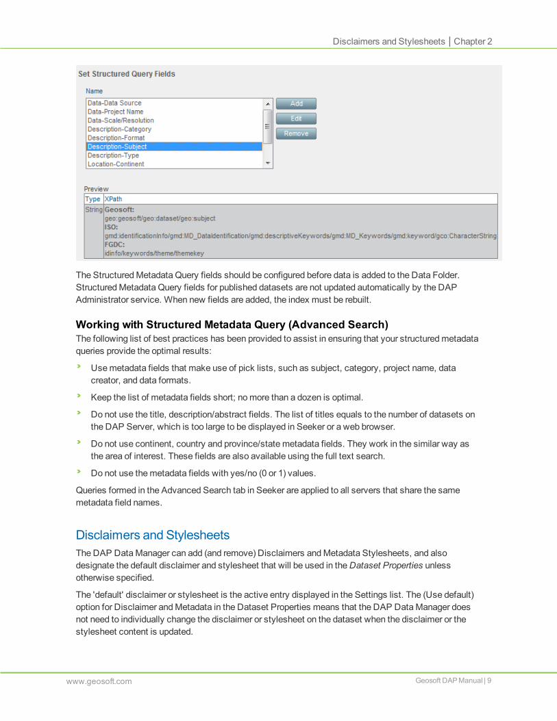
StructuredMetadata QueryDAP Server supports the ability in Seeker or Flamingo to search for data using specific metadata fieldsin addition to the Text Search. This can refine the data search on large corporate data repositoriesquickly and effectively, and realize the value of the investment in metadata capture.
Specify the tags that will be used to populate the StructuredMetadata Query with values fromdesignatedmetadata fields that will populate the list of values in the DAP client Advanced Searchoptions.
These fields and values are also available to be used for theMetadata Hierarchy.
Only string fields can be used in theMetadata Hierarchy.
8 | Geosoft DAP Manual www.geosoft.com
Chapter 2 | StructuredMetadata Query
Disclaimers and Stylesheets | Chapter 2
The StructuredMetadata Query fields should be configured before data is added to the Data Folder.StructuredMetadata Query fields for published datasets are not updated automatically by the DAPAdministrator service. When new fields are added, the index must be rebuilt.
Working with Structured Metadata Query (Advanced Search)The following list of best practices has been provided to assist in ensuring that your structuredmetadataqueries provide the optimal results:
Usemetadata fields that make use of pick lists, such as subject, category, project name, datacreator, and data formats.
Keep the list of metadata fields short; nomore than a dozen is optimal.
Do not use the title, description/abstract fields. The list of titles equals to the number of datasets onthe DAP Server, which is too large to be displayed in Seeker or a web browser.
Do not use continent, country and province/state metadata fields. They work in the similar way asthe area of interest. These fields are also available using the full text search.
Do not use themetadata fields with yes/no (0 or 1) values.
Queries formed in the Advanced Search tab in Seeker are applied to all servers that share the samemetadata field names.
Disclaimers and StylesheetsThe DAP DataManager can add (and remove) Disclaimers andMetadata Stylesheets, and alsodesignate the default disclaimer and stylesheet that will be used in theDataset Properties unlessotherwise specified.
The 'default' disclaimer or stylesheet is the active entry displayed in the Settings list. The (Use default)option for Disclaimer andMetadata in the Dataset Properties means that the DAP DataManager doesnot need to individually change the disclaimer or stylesheet on the dataset when the disclaimer or thestylesheet content is updated.
www.geosoft.com Geosoft DAP Manual | 9

The disclaimer and stylesheet files are stored in the storage folder, which is dependent on whereyour implementer installed it (generally defined during the DAP server installation). An example ofa location can be:
<C:\DAP managed\storage\stylesheet>
<C:\DAP managed\storage\disclaimer>
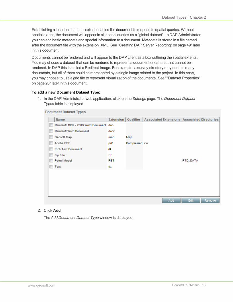
Dataset TypesOnly datasets with extensions that appear in theSpatial Dataset Types and Document Dataset Typestables will be verified from the Incoming folder.
This section shows you how to view supported Spatial Dataset Types and how to add new DocumentDataset Types. See "Supported Dataset Types" (http://www.geosoft.com/products/server-system-requirements#data_formats) for the list of supported file types and the characteristics for each type.
The DAP DataManager can review the list of DAP-supported Spatial Dataset Types. Spatial DatasetTypes supported in DAP cannot be removed in theSettings page. The Dataset Type is a property of thedataset and can only be edited in the database. This property should not generally bemodified except inspecific circumstances. DAP DataManagers should contact DAP Support beforemodifying thisproperty.
Dataset LogicDAP uses the followingmethod to logically determine when separate files belong to the same datasetwhen they are uploaded.
Associated File Extensions - Certain file types can represent a group of files, each with the same nameas the primary file but with a different extension. For example, Esri Shapefile datasets come in a set offiles that relate to the primary file with extension .SHP.
Associated Directories - These directories must be located in a sub-folder accessed from the samelocation as the data file. The associated directory must have the same name as the data file.
The dataset file extensionmust first match the file extension in the Dataset Types list. Then, other fileswith the same root name and extensions that are listed as Associated Extensions are included with thedataset. This is also the case for when the second extensionmatches dataset extension, for exampledatasetname.DEF is associated with datasetname.ABC.
10 | Geosoft DAP Manual www.geosoft.com
Chapter 2 | Dataset Types

Dataset Types | Chapter 2
If there are other files with the same root name as the dataset, they will not be included with the datasetif:
The file has its own xml file, e.g. if filename.MAP.XML exists, then the filename.MAP will not beassociated with a filename.TAB.
The file is listed as its own primary extension, e.g. filename.TIF will not be associated withfilename.GDB.
The file is an associated extension of another dataset, e.g. .DAT is associated with a .TAB file.
The file has double extension equal to another primary extension, e.g. filename.JPG.GI will not beassociated with filename.GRD.
In addition, an asterisk (*) can be used as a wildcard at the end of an associated extension, e.g.<associated_file ext=".HGD*" /> in the Dataset Types list of associated files.
View the Spatial Dataset Type Table
To view the Spatial Dataset Types table:1. In the DAP Administrator web application, click on theSettings page, then select Dataset
Types.
TheDataset Types section is displayed.
2. Under Spatial Dataset Types, click View
TheSpatial Dataset Types window is displayed.
www.geosoft.com Geosoft DAP Manual | 11

The table in the window shows a list of the supported spatial dataset types.
Adding Document Dataset TypesTo enable cataloging of a dataset type that is not included in supported Spatial Dataset Types, youmustadd amapping for this dataset type to the Document Dataset Types table.
Documents are files of any type that you want to make available for distribution in their native format.DAP does not need to understand the file format – it simply delivers the file as is to a DAP client.
12 | Geosoft DAP Manual www.geosoft.com
Chapter 2 | Dataset Types
Dataset Types | Chapter 2
Establishing a location or spatial extent enables the document to respond to spatial queries. Withoutspatial extent, the document will appear in all spatial queries as a "global dataset". In DAP Administratoryou can add basic metadata and special information to a document. Metadata is stored in a file namedafter the document file with the extension .XML. See "Creating DAP Server Reporting" on page 49" laterin this document.
Documents cannot be rendered and will appear to the DAP client as a box outlining the spatial extents.Youmay choose a dataset that can be rendered to represent a document or dataset that cannot berendered. In DAP this is called a Redirect Image. For example, a survey directory may contain manydocuments, but all of them could be represented by a single image related to the project. In this case,youmay choose to use a grid file to represent visualization of the documents. See ""Dataset Properties"on page 28" later in this document.
To add a new Document Dataset Type:1. In the DAP Administrator web application, click on theSettings page. TheDocument Dataset
Types table is displayed.
2. Click Add.
TheAddDocument Dataset Typewindow is displayed.
www.geosoft.com Geosoft DAP Manual | 13

3. In theName field, enter a name for the new Document Dataset Type.
4. In theExtension field, enter the file extension for the new Document Dataset Type. Multipleentries should be entered with a ";" separator.
5. Optionally, enter aQualifier and in theAssociated Extension andAssociated Directories fields,add any associated file or directory extensions, respectively, required for the new dataset type.
6. Click Add.
TheAddDocument Dataset Typewindow closes. The new Document Dataset Type appears intheDocument Dataset Types table.
7. Select aDocument Dataset Type in order toEdit orRemove it.
Datasets with associated extensions download a zip file containing all of the associated files when auser retrieves the dataset via their DAP client application (such as Seeker or Flamingo).
Update ConnectorsConnectors to RDBMS database can refresh on a scheduled basis. This is useful for active projectdatabases.
For information on theConnector Updates options, See ""Creating Data Source Connectors" onpage 40" later in this document.
ArcGIS Image ServicesThe ArcGIS Image Services tab will appear if the DAP Server is licensed for this extension.
This extension is used to publish raster datasets as an image service on an ArcGIS Server. The ArcGISServer software needs to be licensed with the Image Services extension and can be hosted on the DAPServer computer or separate server.
14 | Geosoft DAP Manual www.geosoft.com
Chapter 2 | ArcGIS Image Services

ArcGIS Image Services | Chapter 2
The configuration requires the URL to the ArcGIS Server and a user account that has permission tocreate image services on the ArcGIS Server.
To configure an Image Service:1. Enter the Site URL. This is the address of the ArcGIS Server.
Note the ArcGIS server instance namemust be set to the default ‘arcgis’.
2. Enter the Admin Username for the ArcGIS Server.
3. Enter the Admin Password for the ArcGIS Server.
4. Click Update. If successful, a list of image services on the server will be shown in the ImageServices list.
To create an image service:1. Click Create.
2. Enter a Service name.
3. Optionally, enter a Summary and Description of the service.
4. Click OK.
The image service will be created. The image service will use the same coordinate system asused by the browser map registered on the DAP server. If the browser map is changed, existingimage services are not modified.
www.geosoft.com Geosoft DAP Manual | 15

To remove an existing image service:1. Select the image service.
2. Click Remove.
3. A dialog will appear to confirm that you wish to delete the service. Click Yes.
The image service will be deleted.
To view the rasters included in an image service:1. InSettings > ArcGIS Image Services, select the image service.
2. Click View.
3. When datasets have been added to an image service, a list of datasets in the selected servicewill be displayed.
Any number of Image Services containing one or more rasters can be created using published rastersfrom the DAP Server. Supported data types include:
Geosoft Grid (.grd) -
Note: In order to support Geosoft Grid (.grd) files, the InstallGDALDriver.exe utility (found inthe DAP Admin bin directory C:\Program Files (x86)\Geosoft\DAP Portal\service\bin) mustbe run during setup/upgrade.
ER Mapper (*.ers)
J2K JPEG 2000 Image (*.J2K)
JP2 JPEG 2000 Image (*.JP2)
JPEG Image (*.JPG)
PNG Image (*.PNG)
TIFF Image (*.TIF)
Note: Only one of type of data format (grid or image) should be added to a single image service asthis affects the calculation of statistics. If grids and images aremixed, then one image typemayappear in a uniform colour due to the numeric format of the data.
To add a raster to an image service:1. Open the list of datasets in the Home page.
2. Select one or more published supported raster datasets. Multiple raster datasets can becombined in amosaicked image service and consumed as one dataset.
3. ArcGIS Image Services will appear underDataset Properties.
16 | Geosoft DAP Manual www.geosoft.com
Chapter 2 | ArcGIS Image Services

ArcGIS Image Services | Chapter 2
4. Click Set Image Services and select one (or more) of the Available image services. Click Add>> to make this a Selected image service. The raster(s) will be added to the Selected imageservices.
www.geosoft.com Geosoft DAP Manual | 17

5. To remove a raster from a selected image service, select the image service and click Remove>>. The service will appear in the list of available image services.
Adding or removing datasets from an image service can be a time consuming process, so this is done onthe server as a background task. DAP datasets may take some time to appear in an image service inArcMap. Once a dataset has been successfully added or removed from an image service, a notificationwill appear in DAP Administrator. If an error occurs, more information can be found in the DAP Adminerror log.
UtilitiesThis section provides utilities that would otherwise require direct access to the server to run anexecutable or access to the database.
Update MetadataThis utility run two executables one after another. The first updates themetadata XML files associatedwith datasets and the second updates the search indexes that are used with client applications forfinding datasets in the DAP catalog. There is generally one scenario for why this utility would be run:
Bulk metadata changes –metadata can be changed in the database. After values have beenchanged in themetadata table(s) themetadata XML and search indexes need to be updated toreflect the changes.
Lookup TablesThe Lookup Tables are tables in the DAP catalog database that define the values available in theMetadata Editor pick-list fields. It provides the option to add, edit or delete values in these tables. After atable has been edited, open theMetadata Editor (in Adminmode), and click File>Refresh Lookup Tablesfor the changes to be reflected in theMetadata Editor.
18 | Geosoft DAP Manual www.geosoft.com
Chapter 2 | Utilities

Lookup Tables | Chapter 2
Note: This section only applies to environments that use aGeosoft configuredMetadata Editor.
www.geosoft.com Geosoft DAP Manual | 19

Chapter 3: Publishing Data on a DAP Server
The DAP Administrator enables you tomanage data to be published or already published on your DAPServer. This includes the following:
1. Designing a hierarchy or folder structure within which your data will be presented.
2. Establishing rules for managingmetadata and relatingmetadata entries to the published datafiles.
3. Preparing data to be published, this may be as simple as copying the data to the Incoming folder,or preparing optimizations for certain datasets and establishing appropriate metadata.
This task depends on the objectives you have for your DAP Server, and on thecharacteristics of specific datasets you publish.
4. Creating connector datasets such as acQuire data stored in a relational database (RDBMS).
5. Publishing the data, whichmay involve capturing the requiredmetadata, setting up the requiredfiles, creating visualizations to support visual browsing of your data, and updating the DAPServer that is exposed to your data clients.
6. Managing your data catalog by adding new data, removing unwanted data, and updating certaindynamic dataset types.
Defining a HierarchyYou need to design a logical hierarchy in which you want to present data to be published on your DAPServer. Using the tree view, DAP clients see data organized in a hierarchy of folders and sub folders.The hierarchy can be established usingMetadata or usingUser Specified tags.
User SpecifiedIf Hierarchy is set to use "User specified", then create a folder or folders in the DAP Server’s incomingfolder. The first folder under the Incoming folder will represent a hierarchy tag at level one. A subfolderunder level one will represent a hierarchy tag at level two, and so on.
These hierarchy tags are only usable and visible in DAP Admin and DAP clients if a dataset hasbeen verified and cataloged from within the hierarchy tag. Meaning, empty folders that have nothad datasets uploaded to them will not be seen in DAP Admin or a DAP client.
We recommended limiting the hierarchy to between 4 and 6 levels.

Editing user defined hierarchiesWhen theUser Specified hierarchy setting is applied, the hierarchy that will be presented through theDAP client is shown in theAdvanced Dataset Properties for a single dataset or for multiple selecteddatasets with the same hierarchy values.
Tomake changes to the hierarchy for the select dataset(s), click Edit. TheEdit Hierarchy dialog willdisplay with the number of levels specified in the DAP Administrator Settings.
You can select existing values from the pick list:
21 | Geosoft DAP Manual www.geosoft.com
Chapter 3 | Defining a Hierarchy

Defining a Hierarchy | Chapter 3
Using theAdd/Edit button, you canmodify existing values by selecting an existing value andentering a new value,
or add new values simply by entering a new value.
Once added associated hierarchy level values cannot be removed except via the DAP catalogdatabase.
From MetadataIf Hierarchy is set to use "Frommetadata", then select values from the StructuredMetadata Query listand order them as desired to define whichmetadata tag will represent levels one, two and so on. Usingmetadata as the hierarchy tags provides flexibility when wanting tomodify the hierarchy as displayed inDAP clients.
Note that if you choose to usemetadata as the hierarchy tags then you should be confident that alldatasets have values for the StructuredMetadata Query fields that you choose to use. See ""StructuredMetadata Query" on page 8" later in this document.
Editing MetadataIf your Geosoft Metadata Editor has been configured in the DAP Administrator web application, thentheEdit button will be active when a single dataset is selected.
TheMetadata Editor will open. After making the required updates, click OK to save the changes.
www.geosoft.com Geosoft DAP Manual | 22
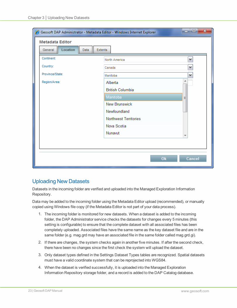
Uploading NewDatasetsDatasets in the incoming folder are verified and uploaded into theManaged Exploration InformationRepository.
Datamay be added to the incoming folder using theMetadata Editor upload (recommended), or manuallycopied usingWindows file copy (if theMetadata Editor is not part of your data process).
1. The incoming folder is monitored for new datasets. When a dataset is added to the incomingfolder, the DAP Administrator service checks the datasets for changes every 5minutes (thissetting is configurable) to ensure that the complete dataset with all associated files has beencompletely uploaded. Associated files have the same name as the key dataset file and are in thesame folder (e.g. mag.grdmay have an associated file in the same folder calledmag.grd.gi).
2. If there are changes, the system checks again in another fiveminutes. If after the second check,there have been no changes since the first check the system will upload the dataset.
3. Only dataset types defined in the Settings Dataset Types tables are recognized. Spatial datasetsmust have a valid coordinate system that can be reprojected intoWGS84.
4. When the dataset is verified successfully, it is uploaded into theManaged ExplorationInformation Repository storage folder, and a record is added to the DAP Catalog database.
23 | Geosoft DAP Manual www.geosoft.com
Chapter 3 | Uploading New Datasets

Uploading New Datasets | Chapter 3
5. If there are any warnings or errors, these are reported in the DAP Administrator log file. If there isan error, the file or connector is not verified. If the dataset fails the verification process, then it ismoved to the quarantine folder and will appear in theError tab.
Depending on the dataset type, verifying a dataset may involve the following procedures:
Reviewing the requiredmetadata
Checking for the required information – such as titles and coordinate systems, either directly in thedatasets or in themetadata XML files
Preparing fast-view images in the coordinate system of the browser map
Preparing work files (such as a data cache) that may be required
A number of supporting files may be created for verified datasets including:
.cache folder - A cache folder is automatically created for some dataset types including SHP andTAB files and warped images
.custom_info - The custom_info file contains information for some datasets that cannot be stored inthe SQL database catalog.
.image_info - The image_info contains information used for the snapshot
.snap_shot - A single 1600x1600 snapshot is used for dataset preview
.properties - The properties file contains internal metadata object information and is used forextraction for some dataset types.
.spatial_image - The spatial_image is a 128x256 bitmap used for large datasets with a dimension of> 7 degrees longitude
The datasets are then available for further preparation and publishing.
www.geosoft.com Geosoft DAP Manual | 24

DAPAdministrator HomeAdministering datasets for publishing on a DAP Server is performed in the DAP Administrator webapplication Home page.
The Home page includes several tabs. TheAll tab is shown below:
List of DatasetsThe List of Datasets contains five tabs: All, Verified, Published, Excluded, andError. TheAll tab showsall datasets in the DAP Catalog database. Other tabs in the List of Datasets organize the datasetsaccording to the status of the dataset.
All - All datasets that exist in the DAP catalog can be listed here.
Verified - New datasets that have been uploaded and passed the verification process. Thesedatasets can be published or excluded as part of the datamanagement workflow. Verified datasetsmeet the following criteria:
The dataset is in the list of supported Spatial Dataset Types or supported Document DatasetTypes.
The dataset can be opened.
If spatial, the dataset must have a coordinate system, and can be reprojected intoWGS84.
25 | Geosoft DAP Manual www.geosoft.com
Chapter 3 | DAP Administrator Home

Search | Chapter 3
Published - Datasets that have been published to the DAP Server.
Excluded - Datasets that have been verified, but are not published and have been excluded by theDAP DataManager.
Error - Supported spatial dataset types that exhibit errors during the verification process will appear inthe Errors tab.
By default, datasets are sorted by the date in theModified column. The List of Datasets can be sorted inascending or descending order by clicking on the field header. The Selection column is also sortable byclicking next to theSelect All checkbox.
Each tab reports a number of datasets in the tab name. Within each tab, only lists up to 500 datasets canbe displayed. If more than 500 datasets exist in a given tab, then a grouped dataset is displayed. TheNumber of Datasets in the list can be changed by the DAP DataManager with theNumber of Datasetsselection. Fewer datasets can also be displayed by using the Search options to filter the list. This isdescribed below in the Search and Advanced Search sections.
SearchThe Search tools are used to filter the List of Datasets to a smaller subset of the DAP Catalog. AGoogle-like search option searches the dataset name.
TheSearch by dataset name option above the List of Datasets provides an easy way to find a specificdataset that requires modifications to dataset properties or status.
TheSearch by dataset name box allows a free text search of all dataset names.
The dataset name as set in themetadatamay be different from the physical file name. The namein the DatasetInformation table is the name that appears here. It can be different from thephysical file name and themetadata title.
To search, simply enter the text and click on the button. Wildcards are not required. A search for"bath" will return all datasets with "bath" anywhere in the dataset name. Wildcard characters are notsupported. The counts for the full List of Datasets and for each tab will be updated.
www.geosoft.com Geosoft DAP Manual | 26

Use theClear Search button to show all datasets. This will remove criteria in theSearch by datasetname field and theAdvanced Search options.
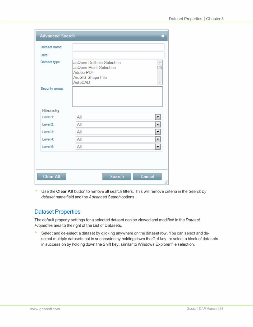
Advanced SearchIn addition to searching by Dataset name, several other options for identifying datasets for selection areavailable in the Advanced Search options, including:
Date - Search by modified date for recently uploaded datasets, or datasets modified within a specificdate range. TheModified date will be updated if all or one of the files in the dataset are replaced or if thepreview image is updated. In the case of dataset connectors, theModified date also reflects when thedataset is refreshed from the data source.
Dataset type - Default supported spatial dataset types and custom added document dataset types arelisted here. Use Ctrl to select and de-select multiple items or the Shift key to select a range.
Security group - Datasets can be identified according to what Security groups have permissions to thosedatasets. Changes can bemade easily and published.
Hierarchy - Using hierarchy levels allows datasets to be searched based on the hierarchy tags asdisplayed in a DAP client. Whether using User Specified Hierarchy or Metadata Hierarchy, theseselections allow the DAP DataManager to identify all datasets that appear to the end user in a givenfolder structure. These options are also useful for a batch exclude or security update actions.
The Hierarchy search will filter subsequent levels according to the hierarchy associations. For example,if there is a Level 1 hierarchy for Canada, Nebraska will not appear in the Level 2 list of availableselections.
27 | Geosoft DAP Manual www.geosoft.com
Chapter 3 | Search
Dataset Properties | Chapter 3
Use theClear All button to remove all search filters. This will remove criteria in theSearch bydataset name field and theAdvanced Search options.
Dataset PropertiesThe default property settings for a selected dataset can be viewed andmodified in theDatasetProperties area to the right of the List of Datasets.
Select and de-select a dataset by clicking anywhere on the dataset row. You can select and de-select multiple datasets not in succession by holding down the Ctrl key, or select a block of datasetsin succession by holding down the Shift key, similar toWindows Explorer file selection.
www.geosoft.com Geosoft DAP Manual | 28

GeneralTheGeneral properties (Name, Size, Loaded,Modified, andStatus) are presented as read only.
Name: This is the Name of the dataset from the dataset or from themetadata, if applicable.
Size: The size of the dataset including associated files.
Loaded: The date and time that the dataset was uploaded to theManaged Exploration InformationRepository.
Modified: Date and time a dataset was modified. Datasets aremodified if part of the dataset is replaced.
Status: Status may be Verified, Published, Excluded, or Error.
If multiple datasets are selected in the List of Datasets, the General area will include a count of thenumber of datasets. Other Dataset Properties will be populated depending on the common properties ofthe datasets that are selected.
TheSize uses the list of associated files to calculate the size. However, it does not examine and includedatasets for all the data connections.
29 | Geosoft DAP Manual www.geosoft.com
Chapter 3 | Dataset Properties

Dataset Properties | Chapter 3
If more than 500 datasets are listed in any tab, a single record representing all datasets will bedisplayed. Selecting this record is the same as selectingmultiple items.
TheCopy Managed Path button can be used to reference the physical location of the dataset in theManaged Exploration Data Repository. This is useful if the dataset needs to be added to an Esri MapService.
AdvancedTheAdvanced section includes Qualifier, Hierarchy, andDisclaimer settings.
Qualifier: Some datasets have aQualifier that is related to the dataset type. The grid and picture typesinclude a qualifier that tells DAP which DAT interface to use to read that data. On occasion, this may bemodified for certain circumstances.
Files of certain types accept a text qualifier that further defines characteristics for connecting to andusing these datasets. The use of qualifiers depends on the file type and on how Geosoft works with thatfile type. Grid and image files use qualifiers to define the format of the grid or image file, which can bedifferent than implied by the actual file extension.
For example, white colour in a TIFF file is interpreted as a blank, and would appear transparent whenvisualized through DAP. If you would like a different colour to be nulled, you can use qualifier“TIFF;dummy=0,0,0”, which will make the transparent colour black (dummy=red,green,blue, each in therange 0 to 255).
Convert to Document: Spatial dataset types have an option toConvert to Document.
The Type will continue to display the original dataset type, but the icon will appear as the document type.
www.geosoft.com Geosoft DAP Manual | 30

The inherent coordinate system, if one exists, will not apply to the new document status, but the extentsspecified in themetadata will be used. This functionality is useful for publishing images, such as photos,that are not georeferenced, have local coordinate systems and fail verification. The dataset can also bereverted back to its original dataset type.
Hierarchy: If the Hierarchy Setting is User specified, then the hierarchy that is presented through a DAPclient is shown here. If the hierarchy path is too long for the screen, the DAP DataManager can previewthe full path via a tool tip.
Click Edit to review ormodify the hierarchy values. If multiple datasets with common values areselected then the hierarchy for all selected datasets can be viewed or modified.
If Hierarchy is set to come frommetadata, then the hierarchy cannot be viewed or edited here.
31 | Geosoft DAP Manual www.geosoft.com
Chapter 3 | Dataset Properties
Dataset Properties | Chapter 3
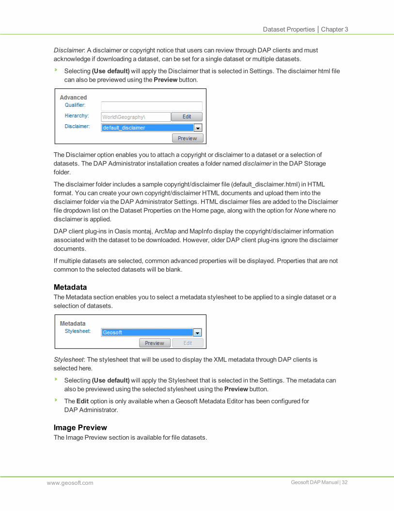
Disclaimer: A disclaimer or copyright notice that users can review through DAP clients andmustacknowledge if downloading a dataset, can be set for a single dataset or multiple datasets.
Selecting (Use default)will apply the Disclaimer that is selected in Settings. The disclaimer html filecan also be previewed using thePreview button.
The Disclaimer option enables you to attach a copyright or disclaimer to a dataset or a selection ofdatasets. The DAP Administrator installation creates a folder named disclaimer in the DAP Storagefolder.
The disclaimer folder includes a sample copyright/disclaimer file (default_disclaimer.html) in HTMLformat. You can create your own copyright/disclaimer HTML documents and upload them into thedisclaimer folder via the DAP Administrator Settings. HTML disclaimer files are added to the Disclaimerfile dropdown list on the Dataset Properties on the Home page, along with the option forNonewhere nodisclaimer is applied.
DAP client plug-ins in Oasis montaj, ArcMap andMapInfo display the copyright/disclaimer informationassociated with the dataset to be downloaded. However, older DAP client plug-ins ignore the disclaimerdocuments.
If multiple datasets are selected, common advanced properties will be displayed. Properties that are notcommon to the selected datasets will be blank.
MetadataTheMetadata section enables you to select ametadata stylesheet to be applied to a single dataset or aselection of datasets.
Stylesheet: The stylesheet that will be used to display the XML metadata through DAP clients isselected here.
Selecting (Use default)will apply the Stylesheet that is selected in the Settings. Themetadata canalso be previewed using the selected stylesheet using thePreview button.
TheEdit option is only available when aGeosoft Metadata Editor has been configured forDAP Administrator.
Image PreviewThe Image Preview section is available for file datasets.
www.geosoft.com Geosoft DAP Manual | 32

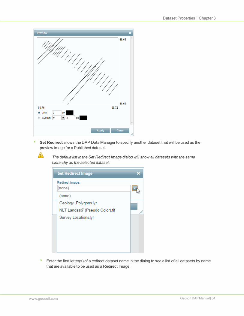
Click Preview to see the snapshot image that will be presented to users via DAP client applications.
Picture file types are always rendered and delivered in an image format.
Rendering attributes are available for point datasets with symbol, size and colour andGeosoftDatabases (GDB) as line with size and colour, or point with symbol, size and colour.
33 | Geosoft DAP Manual www.geosoft.com
Chapter 3 | Dataset Properties
Dataset Properties | Chapter 3
Set Redirect allows the DAP DataManager to specify another dataset that will be used as thepreview image for a Published dataset.
The default list in the Set Redirect Image dialog will show all datasets with the samehierarchy as the selected dataset.
Enter the first letter(s) of a redirect dataset name in the dialog to see a list of all datasets by namethat are available to be used as a Redirect Image.
www.geosoft.com Geosoft DAP Manual | 34

The dataset that is going to be used as a redirect imagemust pass the verification process.The status of the redirect dataset can be Verified, Published, or Excluded.
Set Coordinates is used to set the extents for document dataset types.
SecurityThe Security section enables the DAP DataManager to set the security permissions for a single datasetor selection of datasets.
The DAP DataManager can create DAP Security Groups in the Settings page. Security may bemanaged on an Active Directory (AD) Groupmembership basis, rather than by individual user accounts,to simplify themaintenance of dataset permissions, or with Users so the DAP DataManager has finecontrol over changes.
Use theSettings | Security options to create a new security group to be added to the DAP SecurityGroups window.
There are two options when editing security:
Set Security - Edit the list of security groups that are already set on the dataset(s).
Clear Security - Removes all security groups from the datasets so that you can have a clean slateand add a new group or group(s).
When setting security, there are two permission options:
Extract – User will be granted permissions to preview both image andmetadata and extract thedataset.
Discover – User will only be granted permission to preview themetadata.
When changes aremade to dataset security, the DAP Server must be updated for the changes to takeeffect.
35 | Geosoft DAP Manual www.geosoft.com
Chapter 3 | Security

Updating the DAP Server Catalog | Chapter 3
Updating the DAPServer CatalogOn startup, the DAP Server will read the DAP Catalog SQL Server database and create a cache orindex.The datasetInformation.cache and spatialimages.cache are stored in the Storage folder.
Before logging out of the DAP Administrator web application, or as needed while making changes toDataset Properties, use the greenUpdate DAP Server button to reload the DAP Catalog SQLServer database changes to the DAP Server.
The DAP DataManager will be reminded to perform this action if they logout.
The DAP Server will take approximately oneminute to re-generate the DAP Server catalog cache files.
If Dataset Properties have been applied to a large number of datasets, these changes may notimmediately be visible, but will appear when the database update is complete.
Publishing and Excluding DatasetsUsing thePublish andExclude buttons at the top of the Dataset Properties, recently verifieddatasets can be Published or Excluded, published datasets can be Excluded, and excluded datasetscan be Published.
Excluding DatasetsThe Exclude option enables you to exclude selected data from future publishing or if the data is alreadypublished, it will be removed from the DAP Server.
To Exclude datasets from the DAP Catalog:1. Select the dataset(s) in the List of Datasets.
2. In theDataset Properties. click Exclude.
www.geosoft.com Geosoft DAP Manual | 36

The dataset status is changed to Excluded and the dataset will appear in the Excluded tab. It willbe removed from the catalog, the next time the DAP Server is updated.
Publishing DatasetsBefore publishing datasets, it is expected that the Dataset Properties will be reviewed andmodified asrequired. The Dataset Properties includes areas for General, Advanced, Metadata, Image Preview, andSecurity.
To publish a dataset:1. Select the dataset(s) in the List of Datasets.
2. In theDataset Properties, click Publish.
The dataset status is changed to Published and the dataset will appear in the Published tab. Itwill be added, or updated, the next time the DAP Server is updated.
Offline DatasetsAn offline dataset is a placeholder for a dataset that is discoverable but not available for download. It isrepresented by a georeferenced image that can be previewed. Offline datasets can be useful forpublishing references to very large or confidential datasets. Users can search for and find the dataset,see preview image and review metadata, but they will be unable to download the dataset. Instructions forretrieval such as contact informationmay be included inmetadata or a customized ordering process maybe available.
To create an offline dataset using the Geosoft Metadata Editor, click theNew Offline Datasetmenu andselect aGeoTIFF. You can also directly modify the extension of the zipped preview image for the offlinedataset by changing it from *.tif to *.geosoft_offline file and adding the .geosoft_offline file to the DAPincoming directory.
To create an offline dataset:1. An offline dataset must be created from aGeoTIFF preview image. Rename theGeoTIFF file
extension from *.tif to *.geosoft_offline.
2. In the Geosoft Metadata Editor, select New Data Package and select the .geosoft_offline file.
3. Fill out metadata fields, including instructions on how to obtain the data if required.
4. Submit the dataset to the DAP server to be verified and published.
Updating the DAP ServerOnce data files and connectors have been prepared, they need to be published. The DAP DataManagershould trigger theUpdate DAP Server action tomake published datasets visible in the DAP clients.
If the item has not been published, or if it needs to be updated, the DAP Administrator service addsthe item to the DAP Server cache files and search indexes.
If the item has already been published, the DAP Server does a series of checks to see if this itemneeds to be updated.
If the item is a connector, the DAP Server re-catalogs the item according to the connection rules(See the ""Creating Data Source Connectors" on page 40" section in this document).
If the item has been Excluded, it is ignored.
37 | Geosoft DAP Manual www.geosoft.com
Chapter 3 | Publishing and Excluding Datasets

Setting the Coordinate System of Document Dataset Types | Chapter 3
Once the updating process is complete, the DAP Server is notified that the catalog has been updated,and DAP clients will see the new published datasets in the catalog.
Setting the Coordinate System of Document Dataset TypesTheSet Coordinates options provide functionality to assign a coordinate system and extents todocument dataset.
To set the coordinate system for datasets:1. Select a dataset in the List of Datasets.
2. In the Image Preview section, click Set Coordinates.
TheSet Coordinate System dialog will be displayed.
This dialog provides twomethods to set coordinate system parameters and extents eithermanually by entering the parameters or by copying the parameters from an existing dataset.
3. Click Copy from to define the coordinate system and extents from an existing dataset whenpossible.
If manual entry is necessary, first define the type of coordinate system, Geographic (long, lat) orProjected (x,y).
Unit and Projectionmethod are disabled when theGeographic coordinate system is selected.
www.geosoft.com Geosoft DAP Manual | 38
4. Using the dropdown lists, select Unit, Datum andProjectionmethod (required for the Projectedcoordinate system) and Local Datum (optional).
5. Specify theMinimum andMaximum X and Y Extents.
6. Click OK to apply the coordinate system and extents to the selected datasets.
This option cannot be used tomodify the coordinate system of a spatial dataset.
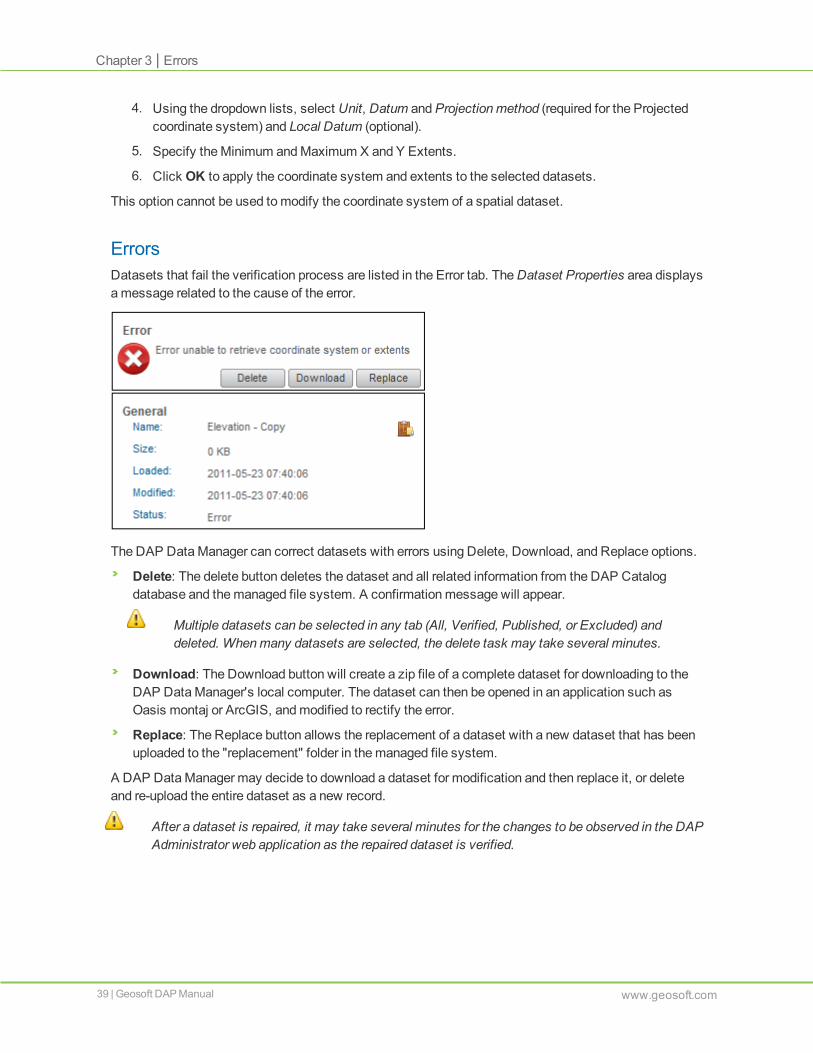
ErrorsDatasets that fail the verification process are listed in the Error tab. TheDataset Properties area displaysamessage related to the cause of the error.
The DAP DataManager can correct datasets with errors using Delete, Download, and Replace options.
Delete: The delete button deletes the dataset and all related information from the DAP Catalogdatabase and themanaged file system. A confirmationmessage will appear.
Multiple datasets can be selected in any tab (All, Verified, Published, or Excluded) anddeleted. Whenmany datasets are selected, the delete task may take several minutes.
Download: The Download button will create a zip file of a complete dataset for downloading to theDAP DataManager's local computer. The dataset can then be opened in an application such asOasis montaj or ArcGIS, andmodified to rectify the error.
Replace: The Replace button allows the replacement of a dataset with a new dataset that has beenuploaded to the "replacement" folder in themanaged file system.
A DAP DataManager may decide to download a dataset for modification and then replace it, or deleteand re-upload the entire dataset as a new record.
After a dataset is repaired, it may take several minutes for the changes to be observed in the DAPAdministrator web application as the repaired dataset is verified.
39 | Geosoft DAP Manual www.geosoft.com
Chapter 3 | Errors

Chapter 4: Creating Data Source Connectors
Some datasets, such as those from acQuire or RDBMS databases, are created with the use of aConnector. A Connector is a file that provides the connection information that enables DAP to connect toan external data source, or perform special actions as part of the publishing process.
Three types of Connectors can be added:
acQuire Selection - For a connection to a point or hole dataset defined by an acQuire Selection file.
RDBMS - For a generic connection to a table or view in a relational database, including Oracledatabases.
Esri Map Service - For a connection to an ArcGIS Server Map Service.
Connectors can be added from below the List of Datasets on the Home page, except when viewing theError tab.
Click theAdd Connector button to select one of these connection types:
For more information on dataset types, see Supported Dataset Types.
Adding an acQuire ConnectorSome organizations store certain exploration drilling and point geochemical data in acQuire databases.Without DAP, geoscientists access this data by making a direct ODBC link to the data and using theacQuire tools embedded in their applications. For example, an ArcGIS user might extract data directlyinto ArcGIS for processing with the Geosoft Target for ArcGIS system. Such applications require a high-speed connection to the database server and cumbersome procedures used to establish andmaintaindirect ODBC database links on the client systems.
When a DAP Server is used to extract the data, DAP is responsible for windowing, re-projecting, andcaching the data tomeet the user's needs. This approach simplifies the client desktop configuration andenables accessing acQuire data over slower connections, such as aWAN, or remotely, using VPN overthe Internet.
If you have an existing acQuire database hosted onMicrosoft SQL Server, there are four steps requiredto connect and catalog the contents of the database through DAP:

1. Enable SQL Server authentication on theMicrosoft SQL Server that hosts the acQuire databaseso the SQL Server can accept a login ID and password for your database.
2. Create a login ID and password for your acQuire database to use for this purpose.
3. Create anODBC System Data Source Name (DSN) on the DAP Server and DAP Administratorcomputer.
4. Create a DAP acQuire selection file to be used to catalog the acQuire dataset on the DAP server.
Creating an acQuire Selection ConnectorDAP can be used to catalog drillhole or surface sample data stored in an acQuire database. The key tothis process is the acQuire Selection (*.SEL) file, which enables DAP DataManagers to define therequired fields and data for each Drillhole or Point Sample dataset.
To create an acQuire Selection Connector for drillhole and point sample data:1. From below the List of Datasets on the Home page, click theAdd Connector button.
2. Select acQuire Selection from theAddConnectormenu.
TheAdd acQuire Selection Connector dialog is displayed.
3. In theDataset name field, type the name to appear in the DAP client for your data users.
Enter the required values for the acQuire Connection Settings including theDSN from the serverthat is hosting the DAP Administrator application, and theUser name andPassword in theacQuire SQL Server database.
User name and Password can bemodified by editing the connector. Dataset name cannotbemodified.
4. Select Drillhole Selection orPoint Sample Selection, depending on the type of acQuire
41 | Geosoft DAP Manual www.geosoft.com
Chapter 4 | Adding an acQuire Connector

Adding an acQuire Connector | Chapter 4
Selection (*.SEL) file that is being used.
5. Browse for theSelection file on your local machine.
6. Click Add and the acQuire database connection will be created and verified.
Once the connector is verified, it will appear in theVerified tab. Modify the Dataset Properties, includingHierarchy, Disclaimer, Metadata, and Stylesheet options. You can then publish the dataset.
You can edit the connection information contained in point datasets via theEdit button in theDataset Properties panel for each dataset.
The acQuire point sample dataset will be visible to your DAP clients as a point dataset type. DAPAdministrator caches the point data as aGeosoft HXYZ file.
The acQuire drillhole dataset will be visible to your DAP clients as a Drillhole Project dataset type. DAPAdministrator caches the data as a set of Geosoft GDB files.
Points and holes can be previewed in the DAP Administrator and will be available in DAP clients as well.
The connector should be updated as more samples or holes are added to the selected projects inacQuire, either manually using theUpdate Connector button, or regularly using theUpdate connectorautomatically option.
www.geosoft.com Geosoft DAP Manual | 42

Creating anODBC ConnectionacQuire connectors use anODBC DSN to connect to the acQuire database. The DSN must be aSystem DSN. BothWindows authentication and SQL authentication are supported. Windowsauthentication uses the user account that the Geosoft DAP Administrator Portal service is runningunder.
To create an ODBC connection to an acQuire server:1. Log in to the system that hosts the DAP server with administrator privileges.
2. From theC:\Windows\SysWOW64\ folder, launch odbcad32.exe.
3. Select theData Sources (ODBC) tool to add a new System DSN.
TheODBC Data Source Administrator dialog is displayed.
The connectionmust be a System DSN because the DAP server will access thisconnection using a different User ID, created specifically for the DAP server when it wasinstalled.
4. Click Add.
5. In the next dialog, select the “SQL Server” driver to access your acQuire database, and click onFinish. The system prompts you for a name for your data connection (this is the DSN name thatyou will need later), and a description.
6. Choose ameaningful name and description, and select the server computer that hosts the
43 | Geosoft DAP Manual www.geosoft.com
Chapter 4 | Creating anODBC Connection

Creating anODBC Connection | Chapter 4
database. Make a note of the DSN name as you will use it in subsequent steps.
7. Click Next. The next dialog asks you how you want to authenticate the Login ID.
8. Choose theSQLServer authentication using a login ID and password entered by the user option.
9. Enter the SQL Server Login ID and password set in theEnabling SQL Server Authenticationsection. The DAP server will also use these parameters to connect to your data.
10. The DAP Server runs under its own user, and this is the only way it can connect to SQL Server.
11. Click Next.
The next dialog prompts you to choose the acQuire database namewithin SQL Server as thedefault database for this connection.
www.geosoft.com Geosoft DAP Manual | 44

12. Select your database from the drop-down list. In the above example, the selected database is“acQuire Banksia”.
13. Click Next and accept the defaults in the next dialog, then click Finish button to complete theconnection.
14. Test your connection in the last dialog by clicking Test Data Source. Your data source willappear on theSystem Data Sources list.
15. Repeat the above process for all acQuire databases you want to make available on your DAPServer.
If you aremanaging your DAP Server from a different computer on your network (which isthe typical configuration), youmust also establish anODBC System DSN connection fromyour administration computer to the same acQuire database. This connection will be usedby DAP Administrator to manage the DAP catalog on the administration computer. Youmust use exactly the sameDSN, Login ID, and password. Once the catalog is created, theDAP Server will access the acQuire database through its ownODBC connection.
Creating an RDBMSConnectorRDBMS (Relational DatabaseManagement System) Connector publishes point data stored in relationaldatabases using ODBC (Open DataBase Connectivity) DSN (Data Source Name) connections. The useof DSN connections enables publishing of point data from relational databases.
To access ODBC, launch odbc32.exe located in the C:\Windows\SysWOW64 directory.
The RDBMS Connector can be used with Access, SQL Server, andOracle databases.
45 | Geosoft DAP Manual www.geosoft.com
Chapter 4 | Creating an RDBMS Connector

Creating an RDBMS Connector | Chapter 4
Point datamust be from a database table or a SQL view which contains X, Y (and optionally Z) columns.Data in X and Y columns must be in a single geographic or projected coordinate system. The connectoruses anODBC DSN to connect to the database. The DSN must be a System DSN. For connections toa SQL database, bothWindows authentication and SQL Server authentication are supported. Windowsauthentication uses the user account that the DAP Administrator service is running under. For MSAccess databases, user name and password are not required. Oracle connectors use a Username andPassword.
To Create an RDBMS Connector:1. From below the List of Datasets on the Home page, click theAdd Connector button.
2. Select RDBMS from theAddConnectormenu.
TheAddRDBMS Connector dialog is displayed.
3. Enter aDataset name to represent the point data in the RDBMS database. This is the name thatwill be displayed in the DAP client interface.
4. In Database Settings, select aDSN Name. The DSN list provides all the System DSNs on thecomputer running DAP Administrator web application.
5. Select a Table or SQL View from the connected database. Move fields to be published from the
www.geosoft.com Geosoft DAP Manual | 46

Available Columns list to the Selected Columns list. Selected Columns can also be re-ordered.
6. In theX, Y, Z columns fields, select X, Y and Z columns from the list of columns chosen above.(Z column is optional.)
7. In theCoordinate system section, select the coordinate system appropriate for the data in the Xand Y columns.
8. Click Add and the RDBMS connector will be created and verified.
User name, Password, Table, columns and column order, and coordinate system can all bemodified by editing the connector after it has been verified or excluded. Dataset namecannot bemodified. To change the Dataset Name, create a new connector.
DAP Administrator caches the data as aGeosoft HXYZ file. The connector should be updated when thecontent of the database changes, either manually using theUpdate Connector button, or regularly usingtheUpdate connector automatically option. See the "Updating Connectors" section in this document.
Creating an Esri Map Service ConnectorTo publish Esri Map Services, the DAP Server requires an Esri License component. The Esri MapService connector contains the parameters for connecting to the ArcGIS Server and theMap Service.
To Create an Esri Map Service Connector:1. From below the List of Datasets on the Home page, click theAdd Connector button.
2. Select Esri Map Service from theAddConnectormenu.
3. TheAdd Esri Map Service Connector dialog is displayed.
4. In theDataset name field specify the name of the connector to create. This is also the name ofthe dataset shown in DAP client interfaces.
5. In theServer box specify the name of the ArcGIS Server computer or IP address.
6. Click Retrieve List to see a list of Map Services hosted by the ArcGIS Server. Select the nameof theMap Service that you would like to publish.
7. Click Add to create the connector.
47 | Geosoft DAP Manual www.geosoft.com
Chapter 4 | Creating an Esri Map Service Connector
Updating Connectors | Chapter 4
Support of Esri Map Services by DAP Client ApplicationsEsri Server Map Services - after being published through a DAP Server - can be searched, viewed anddownloaded in all DAP client interfaces. The native data published by an ArcGIS Server Map Service isnot downloadable; instead, a raster image showing the presentation of the data is extracted and saved toDAP client computers. The raster image is normally a GeoTIFF, and can be reprojected, reformatted andresampled.
Preview of an Esri Map Service is done on-the-fly by the DAP Server with the ArcGIS Server.
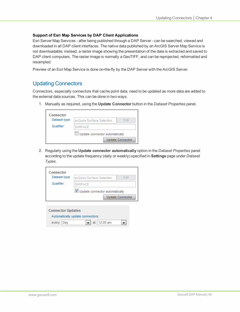
Updating ConnectorsConnectors, especially connectors that cache point data, need to be updated as more data are added tothe external data sources. This can be done in two ways.
1. Manually as required, using theUpdate Connector button in theDataset Properties panel.
2. Regularly using theUpdate connector automatically option in theDataset Properties panelaccording to the update frequency (daily or weekly) specified inSettings page underDatasetTypes.
www.geosoft.com Geosoft DAP Manual | 48

Chapter 5: Creating DAP Server Reporting
DAPServer ReportsA variety of DAP Server usage reports can be viewed in the Reports page of the DAP Administrator webapplication. A collection of reports is provided including reports on uploaded data and download activity:
Dataset Status Summary - Datasets are reported by status and count
Dataset Type Summary - Datasets are reported by type and count
Data Survey Summary - Datasets are reported by a specific metadata field such as primary theme orsubject
Documents without Specified Extents - All documents with global extents (without specifiedextents) are listed
Recent Activities - Loaded datasets are reported by last 60 days, 30 days, last week and current day
Audit Log - A detailed log of datasets downloaded in a specific time period
Download Summary by Datasets - Downloaded datasets are reported by spatial dataset type
Download Summary by User - Downloaded datasets are reported by "who downloaded"
Extraction Profile - Downloaded datasets are displayed as a profile based on extraction date
Request Type Summary - Summary of server requests types
Request Profile - Requests on datasets are displayed as a profile
Duplicates - Datasets with the same name and hierarchy and/or extents are listed here
To create a DAP Server report:1. In the DAP Administrator web application, select theReports page.
2. From theReports dropdown list, select the required report.

3. From theDate Range dropdown list, select the required timeframe.
4. The requested report is generated and displayed.
50 | Geosoft DAP Manual www.geosoft.com
Chapter 5 | DAP Server Reports

Interactive Reports | Chapter 5
5. If needed, export a CSV of the report details.
Interactive Reports
Georeference DAP DocumentsThe results of the Documents without Specified Extents can be selected and the action to Georeference
DAP Documents can be applied using the Georeference DAP Documents button ( ). The coordinatesystem and extents is taken from the first spatial file (including, in priority order, Geosoft Grid, ERmapper ERS, Geosoft GDB, image, or other spatial dataset) with the same hierarchy as the document.A log of the documents processed successfully and failures, together with the spatial dataset used foreach document processed is saved in the outgoing folder.
Update the DAP Server in order for DAP clients to see these changes.
www.geosoft.com Geosoft DAP Manual | 51

Removing Duplicate DatasetsThe results of the Duplicate reports can be selected and the action to Remove Duplicates can be applied
using the Remove Duplicate Dataset(s) button ( ). The name can be used to identify the datasetsin the Dataset List. If the hierarchy is one of the duplicate criteria then this can also be used to find theduplicate datasets. The determination of which datasets are removed is based on the status.
If one of the duplicates has been published, then this published dataset is not removed.
If none of the duplicates are published but one is verified, then this verified dataset is not removed.
If none of the duplicates are published or verified but one dataset has been excluded, then thisexcluded dataset is not removed.
Update the DAP Server in order for DAP clients to see these changes.
Dataset Outputs
Creating an Index MapAn index map is a query-able set of survey or dataset outlines with attributes. This function will create ashapefile of the selected datasets in the List of Datasets, as filtered by the Search options.
1. Use theAdvanced Search to specify a subset of datasets.
2. Select the datasets to be included in the Index Map.
3. Click Index Map.
4. Specify a local location to save the shapefile.
The Index Map shapefile includes a polygon of the dataset bounding box and attributes defined by themetadata fields specified as part of the StructuredMetadata Query.
52 | Geosoft DAP Manual www.geosoft.com
Chapter 5 | Dataset Outputs

Dataset Outputs | Chapter 5
The creation of an Index Map is a DAP Administrator task that is accessible only to the DAP DataManager. The Index Map is not available to the end users through the DAP clients unless it is publishedas a DAP dataset.
Creating a DAP Administrator Data PackagePackage is a DAP Administrator tool that can be used by the DAP DataManager to extract a subset ofdata in the same folder hierarchy as seen in the DAP client. This can be useful to share data with userswho don't have access to the DAP Server, such as contractors or consultants.
1. Use theAdvanced Search to specify the subset of datasets.
2. Select the datasets to be included in the Index Map.
3. Click Package.
A separate process will create a new file named "Package_yyyy-mm-dd_#.zip" in the outgoingfolder of the DAP Data folder.
The files in the Data Package zip file will unzip based on the presentation hierarchy that an end user of aDAP client would see.
www.geosoft.com Geosoft DAP Manual | 53


