Page 1 of 2 DATA & TOOLS Compiled by the Calumet Stormwater Collaborative The Calumet Stormwater Collaborative repository data and tools section provides accessible stormwater resources that can be useful for data analysis, mapping, and to design and calculate the benefits of stormwater BMPs. Hyperlinked names take you to each resource. Data and Imagery Name Organization Description Census data U.S. Census Bureau Online catalog of census data. CMAP Data Hub Chicago Metropolitan Agency for Planning Online catalog of data and information relevant to comprehensive planning in the seven-county metropolitan Chicago region. Datasets include urban tree canopy, land use, and green infrastructure vision, among others. CMAP Imagery Explorer: Historic Aerials (1970,1995) Chicago Metropolitan Agency for Planning Interactive web app to browse and download scanned aerial photography of the Chicago region from 1970 and 1995. Collaborative Stormwater Viewer Calumet Stormwater Collaborative in partnership with CH2M Hill and South Suburban Mayors and Managers Association Online mapping tool with several layers that are helpful for stormwater planning. It aggregates 25 different datasets at a single location and makes it readily available for anyone to access for free. Combined Sewer Overflow Waterway System map Metropolitan Water Reclamation District Online map to view combined sewer overflow (CSO) events in the reaches of the Chicago Area Waterway System (CAWS). Cook County Data Hub Cook County Online catalog of data relevant to Cook County. HistoricAerials.com NETR Online Online catalog of historical aerial imagery and topgographical maps. Imagery and maps can be purchased or viewed through an online viewer. Hydrologic Atlases U.S. Geological Survey in partnership with the Northeastern Illinois Planning Commission (NIPC) Maps providing hydrologic data on flood depth and frequency within historic floodplain areas for northeastern Illinois. The maps were prepared in the 1960s and the data dates back to the 1940s and 1950s. Illinois Flood Map Database Illinois State Water Survey Online catalog of preliminary and final digital Flood Insurance Rate Maps (dFIRMs), Discovery mapping products, and other relevant flood-related maps. Illinois Geospatial Data Clearinghouse Illinois State Geological Survey Online catalog of data for the State of Illinois, including elevation, geology, hydrology, landcover, historical imagery, among other datasets. Mitigation Action Tracker Federal Emergency Management Agency National web-based interactive mapping tool developed by FEMA to collect and track local hazard mitigation actions that have been proposed, fully funded, or completed. The Tracker is intended to help Risk MAP providers, mitigation planners, and stakeholders track flood mitigation actions to identify opportunities for implementation. Soil Survey of Cook County, Illinois U.S. Department of Agriculture National Resources Conservation Service Soil survey of Cook County that includes detailed soil maps, soil series descriptions, information on the use and management of the soils, and soil properties. Results have been incorporated into the USDA NRCS Web Soil Survey application. SSMMA Open Data Portal South Suburban Mayors and Managers Online catalog of public data relevant to SSMMA's region. Data can be previewed in a map and downloaded as a spreadsheet, shapefile, KML, or linked via Application Programming Interface (API). USGS Maps and GIS Data U.S. Geological Survey Online catalog of public data on surface water, groundwater, water quality, and other themes. Web Soil Survey U.S. Department of Agriculture National Resources Conservation Service Interactive soil mapping tool that allows users to explore the National Resources Conservation Service (NRCS) soil database, generate soil reports and maps, and download the spatial data associated with an area of interest.
Transcript
Page 1 of 2
DATA & TOOLSCompiled by the Calumet Stormwater Collaborative
The Calumet Stormwater Collaborative repository data and tools section provides accessible stormwater resources that can be useful for data analysis, mapping, and to design and calculate the benefits of stormwater BMPs. Hyperlinked names take you to each resource.
Data and ImageryName Organization Description
Census data U.S. Census Bureau Online catalog of census data.
CMAP Data Hub Chicago Metropolitan Agency for Planning
Online catalog of data and information relevant to comprehensive planning in the seven-county metropolitan Chicago region. Datasets include urban tree canopy, land use, and green infrastructure vision, among others.
Chicago Metropolitan Agency for Planning Interactive web app to browse and download scanned aerial photography of the Chicago region from 1970 and 1995.
Collaborative Stormwater Viewer
Calumet Stormwater Collaborative in partnership with CH2M Hill and
South Suburban Mayors and Managers Association
Online mapping tool with several layers that are helpful for stormwater planning. It aggregates 25 different datasets at a single location and makes it readily available for anyone to access for free.
Combined Sewer Overflow Waterway System map
Metropolitan Water Reclamation District Online map to view combined sewer overflow (CSO) events in the reaches of the Chicago Area Waterway System (CAWS).
Cook County Data Hub Cook County Online catalog of data relevant to Cook County.
HistoricAerials.com NETR Online Online catalog of historical aerial imagery and topgographical maps. Imagery and maps can be purchased or viewed through an online viewer.
Hydrologic Atlases
U.S. Geological Survey in partnership with the Northeastern
Illinois Planning Commission (NIPC)
Maps providing hydrologic data on flood depth and frequency within historic floodplain areas for northeastern Illinois. The maps were prepared in the 1960s and the data dates back to the 1940s and 1950s.
Illinois Flood Map Database Illinois State Water Survey Online catalog of preliminary and final digital Flood Insurance Rate Maps (dFIRMs), Discovery mapping products, and other relevant flood-related maps.
Illinois Geospatial Data Clearinghouse Illinois State Geological Survey Online catalog of data for the State of Illinois, including elevation, geology, hydrology, landcover, historical imagery, among
other datasets.
Mitigation Action Tracker Federal Emergency ManagementAgency
National web-based interactive mapping tool developed by FEMA to collect and track local hazard mitigation actions that have been proposed, fully funded, or completed. The Tracker is intended to help Risk MAP providers, mitigation planners, and
stakeholders track flood mitigation actions to identify opportunities for implementation.
Soil Survey of Cook County, Illinois
U.S. Department of Agriculture National Resources Conservation
Service
Soil survey of Cook County that includes detailed soil maps, soil series descriptions, information on the use and management of the soils, and soil properties. Results have been incorporated into the USDA NRCS Web Soil Survey application.
SSMMA Open Data Portal South Suburban Mayors and Managers
Online catalog of public data relevant to SSMMA's region. Data can be previewed in a map and downloaded as a spreadsheet, shapefile, KML, or linked via Application Programming Interface (API).
USGS Maps and GIS Data U.S. Geological Survey Online catalog of public data on surface water, groundwater, water quality, and other themes.
Web Soil SurveyU.S. Department of Agriculture
National Resources Conservation Service
Interactive soil mapping tool that allows users to explore the National Resources Conservation Service (NRCS) soil database, generate soil reports and maps, and download the spatial data associated with an area of interest.
DATA & TOOLSCompiled by the Calumet Stormwater Collaborative
Data and ImageryName Organization Description
Wetlands Mapper National Wetlands Inventory (NWI) Interactive wetland mapping tool that allows the user to explore the National Wetlands Inventory database and download data.
Design Tools and Benefits CalculatorsName Organization Description
Green Values Stormwater Management Calculator
Center for Neighborhood Technology
Easy-to-use calculator to quantify the difference between utilizing gray infrastructure and green infrastructure in terms of the life cycle costs, co-benefits, and peak discharge reduction. This calculator can help make the case for incorporating green
infrastructure into site design.Integrated Valuation of
Ecosystem Services and Tradeoffs (InVEST) v3.3.3
The Natural Capital Project Tool to map and value ecosystem services of natural systems.
i-TREE Streets U.S. Forest Service Free software to conduct and analyze a street tree inventory, including quantifying the environmental benefits of trees such as stormwater management.
Landscape Green Infrastructure Design Model and Participatory Modeling
Protocol
University of Illinois at Chicago
The landscape green infrastructure design model (L-GrID) is a simulation model to design and assess different green infrastructure scenarios to address urban flooding. Participatory modeling protocol was developed to help communities
collectively design, test, and resolve tradeoffs of different green infrastructure solutions. Contact Dr. Moira Zellner ([email protected]) for more information.
National Stormwater Calculator
U.S. Environmental Protection Agency
Free software used to estimate runoff volumes for a specific site and assess the level to which green infrastructure practices can be utilized to meet a stormwater retention goal.
WMO Model Templates Metropolitan Water Reclamation District WMO-compliant templates for HEC-HMS, TR-20, and Win TR-20 models.
DESIGN & IMPLEMENTATIONCompiled by the Calumet Stormwater Collaborative
The Calumet Stormwater Collaborative repository design and implementation section provides accessible stormwater resources related to green infrastructure design, implementation, and contruction. Hyperlinked names take you to each resource.
Design GuidelinesName Organization Description
Appendix C. Standard Details and Notes of WMO's
Technical Guidance Manual (TGM)
Metropolitan Water Reclamation District Webpage of standard design details for green and grey infrastructure practices that are in compliance with the WMO.
CDOT Sustainable Urban Infrastructure: Policies and
Guidelines, Vol. 1
Chicago Department of Transportation
This document establishes requirements, standards, and policies to help the City of Chicago design, build, and maintain sustainable infrastructure within the public right-of-way to address environmental issues, build resiliency, and improve quality of
life.Green Infrastructure Design
GuidelineAmerican Society of Landscape
ArchitectsWebsite describing the benefits, contexts, and types of green infrastructure and is a robust resource for links to organizations,
landscape performance research, and project examples.Green Infrastructure Designs:
Scalable Solutions to Local Challenges
Delta Institute, in partnership with the Calumet Stormwater
Collaborative
Guidance on the selection, siting, and design of green infrastructure practices and detailed design templates for bioswales, stormwater planters, rain gardens, underground storage, and pervious pavement.
Green River Pattern Book: An Illustrated Guide to
Sustainable Urban Planning and Design Principles and
Environmental Design / Energy Conservation Best
Practices
South Suburban Mayors and Managers Association, Chicago
Southland Development Corporation, Hitchcock Design
Group
The Pattern Book provides information on green infrastructure practices and other sustainable development techniques that can be applied to sites and conditions across the Calumet River Corridor in the communities of Blue Island, Burnham, Calumet
City, Calumet Park, Dolton, Riverdale, and Robbins.
Rain Gardens: A how-to manual for homeowners
Wisconsin Department of Natural Resources and University of
Wisconsin-ExtensionA guide for homeowners and professional landscapers to design and build rain gardens on residential properties.
Sustainable Sites Initiative (SITES)
SITES is a combined effort of the American Society of Landscape
Architects, The Lady Bird Johnson Wildflower Center at The
University of Texas at Austin, and the United States Botanic Garden.
It is now run by U.S. Green Building Council.
SITES is a program to guide and certify the sustainable design of sites, equivalent to LEED (system by the U.S. Green Building Council (USGBC). The USGBC has adopted its rating system and offers SITES courses.
Watershed Management Ordinance (WMO) Design
Calculators
Metropolitan Water Reclamation District
Spreadsheets to calculate stormwater runoff rates and volumes, detention storage, and hydraulic structure sizing to meet MWRD's Watershed Management Ordinance for site development or redevelopment.
DESIGN & IMPLEMENTATIONCompiled by the Calumet Stormwater Collaborative
Implementation and Construction StrategiesName Organization Description
City Green: Innovative Green Infrastructure Solutions for
Downtowns and Infill Locations
U.S. Environmental Protection Agency
A collection of case studies highlighting green infrastructure projects that overcame challenges commonly faced when working with infill sites.
Stormwater Trees U.S. Environmental Protection Agency
Technical memorandum on planting and maintaining trees adjacent to roadways or sidewalks in urban areas suffering from urban heat island impacts, stormwater management issues, shade deficits, and other issues.
Greening Vacant Lots: Planning and Implementation
Strategies
NatLab collaboration (Natural Resources Defense Council, The Nature Conservancy, and EKO
Asset Management Partners)
A collection of case studies highlighting tools various cities have employed to turn vacant lots into more productive uses such as green infrastructure for stormwater management.
Illinois Urban ManualAssociation of Illinois Soil and Water Conservation Districts
(AISWCD)
Manual outlining best management practices (BMPs) for controlling nonpoint source pollution within existing and developing urban areas through soil erosion and sediment control, stormwater management, and special area protection.
Landscape Performance Series
Landscape Architecture Foundation
Website containing green infrastructure case studies, high level statistics that are useful for green infrastructure rationale, and online calculators for estimating and planning landscape performance.
National Green Infrastructure Certification Program: Body
of Knowledge
DC Water & the Water Environment Federation
Compilation of reference materials on green infrastructure construction, inspection, and maintenance that were identified as part of the National Green Infrastructure Certification Program (NGICP).
EDUCATION & ENGAGEMENTCompiled by the Calumet Stormwater Collaborative
The Calumet Stormwater Collaborative repository education and engagement section provides accessible stormwater resources that can be useful to local government staff, homeowners, and the general public. Hyperlinked names take you to each resource.
Factsheets and PamphletsName Organization Description
Rainready Factsheets Center for Neighborhood Technology Factsheets that provide information on urban flooding, stormwater management, and other related topics.
Stream Maintenance Brochure
Metropolitan Water Reclamation District
A pamphlet for the general public that describes the importance of regular neighborhood stream maintenance to ensure natural function and prevent flooding.
Understanding Your Sewer Metropolitan Water Reclamation District This document explains how a combined sewer system works, and what causes sewer overflows and backups.
World Meteorological Organization Information
Pamphlets for Developers and Homeowners
Metropolitan Water Reclamation District
These documents provide general information for developers and homeowners regarding the need for a World Meteorological Organization permit.
World Meteorological Organization Short Summary
Metropolitan Water Reclamation District This brochure provides general information on flood prevention and stream maintenance.
Reports and ManualsName Organization Description
Banking on Green: How Green Infrastructure Can
Save Municipalities Money and Provide Economic
Benefits Community-Wide
American Society of Landscape Architects, American Rivers,
Water Environment Federation, and ECONorthwest
This easy-to-understand report is intended for local government and the general public. It focuses on the economic impacts caused by polluted urban runoff and explores how to implement green infrastructure in cost-effective ways.
City Parks, Clean Water The Trust for Public Land This document provides resources for municipalities to turn parks into green infrastructure resources.
The Southern Lake Michigan Rain Garden Manual
Purdue University, Lake Champlain Sea Grant, Great
Lakes Restoration, Illinois-Indiana Sea Grant, University of Illinois, and Northwest Indiana Regional
Planning Commission
This document is a step-by-step guide to rain gardens for homeowners, landscape architects, and city planners.
FUNDING & FINANCINGCompiled by the Calumet Stormwater Collaborative
The Calumet Stormwater Collaborative repository funding and finance section provides key resources that can help public and non-profit organizations pay for stormwater management efforts. The information below provides a brief description of each opportunity, as well as hyperlinked names to more detailed information.
Brownfield GrantsGrant Name Grant-Making
Organization Eligible Recipients Description
Brownfields Area-Wide Planning (BF AWP) Grant
Guidelines
U.S. Environmental Protection Agency Public and non-profit organizations Funding for research and/or technical assistance to develop a site-specific plan for a brownfield assessment,
cleanup, and subsequent reuse.
Technical Assistance to Brownfields Communities
(TAB)
U.S. Environmental Protection Agency Local governments Provides technical assistance to communities on brownfields issues to increase understanding and
involvement in cleanup and revitalization, and help move brownfield sites toward cleanup and reuse.
U.S. Environmental Protection Agency Local governments
Presents a model Community Based Public Private Partnership (CBP3) program, with a variety of emerging market-based tools, to help municipalities in the Chesapeake Bay region meet their stormwater management regulatory and community development program needs. While the focus is outside of the Chicago region, it provides a model for engaging and educating stakeholders on the use of P3s for stormwater management.
Green Infrastructure Designs Delta Institute Local governments A toolkit which features a decision support tool and design templates to help communities to implement scalable green infrastructure projects.
State Revolving FundIllinois
Environmental Protection Agency
Municipalities, public water service utilities, NGOs
A federal, low-interest loan program for capital improvement projects for water, wastewater, and stormwater infrastructure. Stormwater and green infrastructure projects are now eligible for funding via this source, and
NGO’s are also now eligible grantees.
Steady Streams Metropolitan Planning Council Local governments A guide to help municipalities identify avenues to reliably and consistently generate adequate funds to
manage stormwater.Tapping into Alternative
Ways to Fund Innovative and Multi-Purpose Water Projects
Stanford Woods Institute for the
EnvironmentState and local governments
A paper that identifies funding mechanisms from the electricity sector that could be applied to the water sector. The research focuses on renewable generation and electricity demand-side management (DSM)
practices in particular.
Tree Asset Management in Portland, Oregon
The Center for Neighborhood
TechnologyLocal governments A study that evaluates Portland, Oregon's approach to tree canopy cover and that offers a tree asset
management (TAM) approach for the city. The recommendations are more broadly applicable to other cities.
The Value of Green Infrastructure
The Center for Neighborhood
TechnologyLocal governments and communities A guide that informs decision-makers and planners about the multiple benefits of green infrastructure and that
helps communities determine how to assess the value of green infrastructure investments.
Water Finance Clearinghouse
U.S. Environmental Protection Agency Local governments and communities
A navigable, web-based portal to help communities locate information and resources that will assist them in making informed decisions for their drinking water, wastewater, and stormwater infrastructure needs. There
are two searchable data sets: 1) federal, state, and local funding sources for water infrastructure and 2) reports, tools, webinars, and other resources on financing mechanisms and approaches.
FUNDING & FINANCING Compiled by the Calumet Stormwater Collaborative
Flood Mitigation GrantsGrant Name Grant-Making
Organization Eligible Recipients Description
Flood Mitigation Assistance Program
Federal Emergency Management
Agency
States, Tribal, Territorial and local governments
Provides funding for projects and planning that reduces or eliminates risk of flood damage to structures insured under the NFIP, and can also cover management costs. Applicants must have an adopted hazard
mitigation plan in order to be eligible for funding.
Hazard Mitigation Grant Program
Federal Emergency Management
Agency
States, Tribal, Territorial and local governments
Offers funding to protect life and property from future natural disasters. Criteria for eligibility include: properties have experienced several flood inundation events with damage to over 50% of the property,
repetitive loss, and market loss exceeding 25%. Applicants must also have an adopted hazard mitigation plan to be eligible.
MWRD Flood-Prone Property Acquisition Program
Metropolitan Water Reclamation District Local communities Provides assistance to local communities to acquire flood-damaged and flood-prone homes on a voluntary
basis.
Pre-Disaster Mitigation Program
Federal Emergency Management
Agency
States, Tribal, Territorial and local governments
Awards planning and project grants to reduce future losses before disaster strikes. Applicants seeking funding for a project must have an adopted hazard mitigation plan in order to be eligible.
Section 205: Small Flood Risk Management Projects
U.S. Army Corps of Engineers
Local governments, State Authorized Agencies, non-profit organizations
Funding to construct site-specific local flood protection projects or improvement of flood control works. The U.S. Army Corps of Engineers oversees planning, design, and construction of flood risk management projects in
close coordination with the project sponsor.
Green and Grey Infrastructure GrantsGrant Name Grant-Making
Organization Eligible Recipients Description
Chi-Cal Rivers Fund National Fish and Wildlife Foundation
Non-profit organizations, educational institutions, and state, tribal and local
governments.
Funds on-the-ground projects that support green stormwater infrastructure, habitat enhancement, and public-use improvements within the waterways in the Chicago and Calumet regions.
Great Lakes Shoreline Cities Green Infrastructure Grants
(GLRI funds)
U.S. Environmental Protection Agency
Lake Michigan shoreline communities with population between 25,000 and
50,000Funds green infrastructure projects on public property that will improve Great Lakes water quality.
IDNR Coastal Management Grants
Illinois Department of Natural Resources
Communities, agencies, and NGO’s with projects within the Illinois Coastal
Management Zone.
Provides capital for communities within the coastal zone to fund various stormwater infrastructure projects that align with the mission of the program.
MWRD Green Infrastructure Program
Metropolitan Water Reclamation District Local communities, agencies Provides assistance to local communities and agencies to address local drainage problems and improve
water quality through green infrastructure projects.MWRD Stormwater
Management Phase II (Localized) Flood Control
Program
Metropolitan Water Reclamation District Local communities, agencies Provides assistance to local communities and agencies to address local drainage problems.
Section 14: Emergency Streambank and Shoreline
Protection
U.S. Army Corps of Engineers
Local governments, State Authorized Agencies, non-profit organizations
Funds construction for endangered highways, highway bridge approaches, and other essential, important public works, such as municipal water supply systems and sewage disposal plants, churches, hospitals,
schools, and non-profit public services and known cultural sites that are endangered by flood-caused bank or shoreline erosion.
FUNDING & FINANCINGCompiled by the Calumet Stormwater Collaborative
Green and Grey Infrastructure GrantsGrant Name Grant-Making
Organization Eligible Recipients Description
Section 219: Environmental Infrastructure Program
U.S. Army Corps of Engineers
Local governments, State Authorized Agencies, non-profit organizations
Provides technical, planning and/or design assistance to non-federal entities in Cook County, IL, as well as Benton, Jasper, Lake, Newton and Porter counties in Indiana, in water-related environmental infrastructure
and resource protection and development projects.
Sustain our Great Lakes National Fish and Wildlife Foundation
Non-profit organizations, educational institutions, and state, tribal and local
governments.
Funds restoration and protection of wildlife and habitat in the Great Lakes basin. Priority is given to projects that restore aquatic connectivity and stream, riparian, wetland, and coastal habitat. Green Stormwater
Infrastructure (GSI) was a new funding category in 2017.
Urban Waters Small Grants Program
U.S. Environmental Protection Agency
States, local governments, Indian Tribes, educational institutions, public
or private NPOs, intertribal consortia, and interstate agencies.
Assists residents and organizations in underserved communities to address urban runoff and support economic revitalization. There is an interest in projects that also support the growth and development of local
business as well as the establishment of new educational, employment, and recreational opportunities.
Planning GrantsGrant Name Grant-Making
Organization Eligible Recipients Description
Section 22 - Planning Assistance to States and
Tribes
U.S. Army Corps of Engineers
Local governments, State Authorized Agencies, non-profit organizations
Planning assistance for states, eligible Native American Indian tribes, and local governments to prepare plans and initiate actions to manage water and related land resources. Typical studies are only planning level of
detail; they do not include detailed design for project construction.
Restoration and Open Space GrantsGrant Name Grant-Making
Organization Eligible Recipients Description
Chi-Cal Rivers Fund National Fish and Wildlife Foundation
Non-profit organizations, educational institutions, and state, tribal and local
governments.
Funds on-the-ground projects that support green stormwater infrastructure, habitat enhancement, and public-use improvements within the waterways in the Chicago and Calumet regions.
ComEd Green Region Program
Openlands and ComEd
Public agencies in ComEd’s service area of northern Illinois.
Grants of up to $10,000 for open space projects that focus on planning, acquisition, and improvements to local parks, natural areas, and recreation resources. Priority is given to projects that demonstrate
partnerships and significant impact on the surrounding community by increasing public access.Community Trees Program-
Urban Forestry Annual Grant List
Morton Arboretum Multiple eligible recipients, but includes local governments
Several grant programs focused on community tree and forestry grants, corporate grants for community, state grants, and other opportunities.
Section 206: Aquatic Ecosystem Restoration
U.S. Army Corps of Engineers
Local governments, State Authorized Agencies, non-profit organizations
Supports aquatic ecosystem restoration and protection projects that improve the quality of the environment and are in the best interest of the public.
Section 506: Great Lakes Fishery & Ecosystem
Restoration
U.S. Army Corps of Engineers
Local governments, State Authorized Agencies, non-profit organizations
Assists in planning, design, and construction of projects to protect and/or restore the fishery, ecosystems, and beneficial uses of the Great Lakes.
Sustain our Great Lakes National Fish and Wildlife Foundation
Non-profit organizations, educational institutions, and state, tribal and local
governments.
Funds restoration and protection of wildlife and habitat in the Great Lakes basin. Priority is given to projects that restore aquatic connectivity and stream, riparian, wetland, and coastal habitat. Green Stormwater
Infrastructure (GSI) was a new funding category in 2017.
FUNDING & FINANCINGCompiled by the Calumet Stormwater Collaborative
Water Quality GrantsGrant Name Grant-Making
Organization Eligible Recipients Description
Community Partnership Program
Great Lakes Clean Communities
Network (GLCCN)
Recipients must be members of the GLCCN.
Small grant program that funds practice- or activity-based projects that directly improve water quality or support GLCCN's "Eco Score" indicators such as tree planting, erosion control, river cleanups, or green
infrastructure.
Five Star & Urban Waters Restoration Program
National Fish and Wildlife Foundation
Non-profit organizations, educational institutions, and state, tribal and local
governments.
Funds projects that address water quality issues in priority watersheds (e.g., stream bank erosion, stormwater runoff pollution, and degraded shorelines) through community partnerships, stewardship, outreach, education,
training, and on-the-ground restoration of coastal wetland and riparian ecosystems. There is at least a 1:1 match ratio to be competitive.
Great Lakes Restoration Initiative
U.S. Environmental Protection Agency
Eligible nonprofits, state gov. agencies, local govs, municipal
governments, Indian tribes and edu. Institutions
Funds non-federal partners to implement projects that protect and restore the Great Lakes region. The program is guided by the GLRI Action Plan II, which supports
green infrastructure and watershed management projects. Funded projects will build on work implemented under the initial GLRI Action Plan, as well as focus on: cleaning up Great Lakes Areas of Concern; preventing
and controlling invasive species; reducing nutrient runoff that contributes to harmful/nuisance algal blooms; and restoring habitat to protect native species.
Entities that have legal status to accept state funds (watershed groups,
private orgs, non-profits, land conservancies or trusts, gov. agencies, edu. institutions).
Funds local government and other organizations to implement projects that utilize cost-effective best management practices (BMPs) for non-point pollution on a watershed scale. Projects may include structural
BMPs such as detention basins and filter strips and non-structural BMPs such as construction erosion control ordinances and setback zones to protect community water supply wells. Communities that fall within the
planning boundary of an EPA-compliant watershed are eligible to receive financial assistance to support on-the-ground implementation and installation of green infrastructure and other stormwater management
projects. Applicants must be pre-qualified through the Grant Accountability and Transparency Act (GATA) Grantee Portal. See https://www.illinois.gov/sites/GATA/Grantee/Pages/default.aspx
Urban Waters Small Grants Program
U.S. Environmental Protection Agency
States, local governments, Indian Tribes, educational institutions, public
or private NPOs, intertribal consortia, and interstate agencies.
Assists residents and organizations in underserved communities to address urban runoff and support economic revitalization. There is an interest in projects that also support the growth and development of local
business as well as the establishment of new educational, employment, and recreational opportunities.
POLICIES & REGULATIONSCompiled by the Calumet Stormwater Collaborative
The Calumet Stormwater Collaborative repository policies and regulations section provides accessible resources related to stormwater regulations, policy, and ordinances. Hyperlinked names take you to each resource.
Illinois Drainage Law University of Illinois Describes the legal principles related to drainage for the entire state of Illinois, including guidelines for erosion and sediment control, requirements to obtain a permit to construct in streams or floodways, and federal wetlands provisions.
Joint Permit Application
Illinois Department of Natural Resources, Illinois Environtmental
Protection Agency, U.S. Army Corps of Engineers
Joint permit application instructions and forms for construction projects in Illinois waterways, floodplains and wetlands.
Watershed Management Ordinance
Metropolitan Water Reclamation District
The Watershed Management Ordinance (WMO) regulates qualified sewer construction, drainage and detention, volume control, floodplain management, wetland and riparian protection, and erosion and sediment control and applies to all
development within Cook County and qualified sewer construction within MWRD's boundaries or service agreement areas.WMO Technical Guidance
ManualMetropolitan Water Reclamation
DistrictThis manual provides information about MWRD's Watershed Management Permit process, including the types of permits,
information required to complete the application, and examples of successful applications.
Policy DocumentsName Organization Description
Better Site Design Center for Watershed Protection This document provides tools, exercises, and models for adapting local development rules and regulations to protect naturalresources.
Green Infrastructure Opportunities that Arise
During Municipal Operations
U.S. Environmental Protection Agency
This document outlines approaches that local governments can use to incorporate green infrastructure into capital improvements.
Green Infrastructure Portfolio Standard
American Rivers, Center for Neighborhood Technology, Great
Lakes and St. Lawrence Cities Initiative
An approach that local governments can employ to reduce runoff volumes and pollutant loads in urban or developed areas.
Local Water Policy Innovation: A Road Map for
Community Based Stormwater Solutions
American Rivers Outlines how a municipality can improve stormwater management.
Managing Wet Weather with Green Infrastructure
Municipal Handbook Series
U.S. Environmental Protection Agency A step-by-step guide to expanding green infrastructure in communities.
On the Road to Reuse: Residential Demolition Bid Specification Development
Tool Report & Factsheet
U.S. Environmental Protection Agency
Highlights environmental issues associated with residential demolitions and outlines practices to incorporate into the demolition contracting process to achieve better environmental outcomes.
POLICIES & REGULATIONSCompiled by the Calumet Stormwater Collaborative
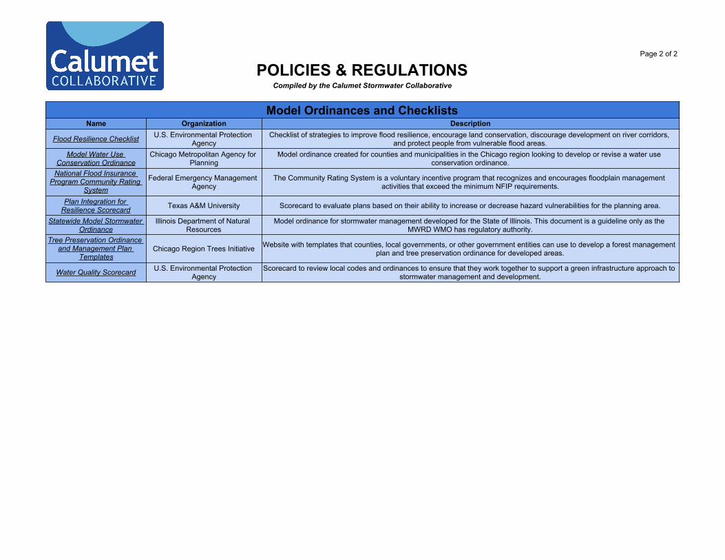
Model Ordinances and ChecklistsName Organization Description
Flood Resilience Checklist U.S. Environmental Protection Agency
Checklist of strategies to improve flood resilience, encourage land conservation, discourage development on river corridors, and protect people from vulnerable flood areas.
Model Water Use Conservation Ordinance
Chicago Metropolitan Agency for Planning
Model ordinance created for counties and municipalities in the Chicago region looking to develop or revise a water use conservation ordinance.
National Flood Insurance Program Community Rating
System
Federal Emergency Management Agency
The Community Rating System is a voluntary incentive program that recognizes and encourages floodplain management activities that exceed the minimum NFIP requirements.
Plan Integration for Resilience Scorecard Texas A&M University Scorecard to evaluate plans based on their ability to increase or decrease hazard vulnerabilities for the planning area.
Statewide Model Stormwater Ordinance
Illinois Department of Natural Resources
Model ordinance for stormwater management developed for the State of Illinois. This document is a guideline only as the MWRD WMO has regulatory authority.
Tree Preservation Ordinance and Management Plan
TemplatesChicago Region Trees Initiative Website with templates that counties, local governments, or other government entities can use to develop a forest management
plan and tree preservation ordinance for developed areas.
Water Quality Scorecard U.S. Environmental Protection Agency
Scorecard to review local codes and ordinances to ensure that they work together to support a green infrastructure approach to stormwater management and development.
STORMWATER PLANNINGCompiled by the Calumet Stormwater Collaborative
The Calumet Stormwater Collaborative repository planning section provides descriptions of plans and reports relevant to the Calumet region. Hyperlinked names take you to the document.
Municipal, County and Watershed-Based Plans, Reports, and GuidesPlan or Report Organization Description
Cal-Sag Channel Detailed Watershed Plan
Metropolitan Water Reclamation District
This detailed watershed plan provides useful information for stormwater and flood mitigation planning to address regional flooding problems along waterways within the Cal-Sag Channel watershed. The plan outlines specific stormwater
improvements for each problem area, analyzes the extent of flooding, and provides potential stormwater alternatives along with benefit-cost information for each proposed stormwater improvement.
Chicago River Watershed Discovery Report
Federal Emergency Management Agency
This report for the Chicago River Watershed documents areas at risk for flooding and solutions to reduce the associated risk. Information was gathered through a community outreach process, which consisted of public meetings and interviews with
stakeholders. Floodplain studies and mitigation projects are recommended for key areas and priority mitigation projects are outlined in more detail. Associated data and maps are also available for download via website.
Chicago Wilderness Green Infrastructure Plan for the
Millennium Reserve
Chicago Wilderness and Illinois Department of
Natural Resources
This plan is the culmination of engagement with South Cook County communities of the Calumet region in a green infrastructure mapping and planning process that documented natural assets, water connectivity, and local stormwater issues.
Identified opportunity areas are included, which allow communities and area partners to use this plan as a reference for mapping future green infrastructure implementation projects and as a reference when applying for grant funding opportunites.
Cook County Stormwater Management Plan
Metropolitan Water Reclamation District
This plan provides a framework for Cook County's stormwater program. It identifies stormwater management goals and outlines Metropolitan Water Reclamation District's approach to watershed planning.
Guidance for Developing Watershed Action Plans in
Illinois
Chicago Metropolitan Agency for Planning and
Illinois Environmental Protection Agency
This resource helps guide the creation and development of an effective watershed-planning initiative in order to produce a locally driven watershed action plan.
Little Calumet River Detailed Watershed Plan and Phase B
Report
Metropolitan Water Reclamation District
This detailed watershed plan provides useful information for stormwater and flood mitigation planning to address regional flooding problems along waterways within the Little Calumet River watershed. The plan outlines specific stormwater
improvements for each problem area, analyzes the extent of flooding, and provides potential stormwater alternatives along with benefit-cost information for each proposed stormwater improvement.
Preliminary Assessment of the Potential for Inducing Stormwater Infiltration in
Cook County, Illinois
U.S. Geological SurveyThis study uses hydrogeologic and land cover data to identify areas with the most potential for stormwater infiltration to reduce
combined sewer overflows and increase groundwater recharge. Done in cooperation with MWRD, the assessment provides general locations where infiltrating BMPXs could be sited, though field confirmation of conditions would still be required.
The Prevalence and Cost of Urban Flooding
Center for Neighborhood Technology This report documents research on the prevalence and cost of flooding to property owners in Cook County from 2007 to 2011.
STORMWATER PLANNINGCompiled by the Calumet Stormwater Collaborative
Municipal, County and Watershed-Based Plans, Reports, and GuidesPlan or Report Organization Description
RainReady Calumet Corridor Plan
Center for Neighborhood Technology
This plan outlines recommendations and strategies to strengthen homes, neighborhoods, and communities throughout the Calumet Corridor, including the communities of Blue Island, Calumet City, Calumet Park, Dolton, Riverdale, and Robbins.
Thorn Creek Watershed-Based Plan - Plan Addendum
Chicago Metropolitan Agency for Planning,
Geosyntec, and Illinois Environmental Protection
Agency
This plan provides an update to the 2005 Thorn Creek Watershed Based Plan. It contains a summary of best management practices (BMPs) recommended for implementation within the Thorn Creek Watershed to address water quality issues
idenfitied in that area. Site-specific BMPs identified in the plan could qualify for Section 319 grant funding.
Climate and Hazard Mitigation PlansPlan or Report Organization Description
Chicago Climate Action Plan City of ChicagoThis plan outlines Chicago's plan to reduce emissions and prepare for climate change, including adaptation strategies to
manage stormwater, implement green urban design, and engage the public. The plan includes a municipal climate adaptation guide that is a useful planning tool for other communities.
Cook County Multi-Jurisdictional Hazard
Mitigation Plan
Cook County Department of Homeland Security and Emergency Management
Hazard mitigation plans are important documents to consider in all planning activities, particularly plans that aim to address stormwater and flooding. This plan identifies and recommends ways to reduce risks posed by hazards, including long-term and short-term policies, programs, projects, and other activities within all incorporated and unincorporated areas of Cook County,
and is intended to be used by all local jurisdictions in Cook County.
National Climate Assessment U.S. Global Change Research Program
This document is intended for decision makers at all levels (national to local) as well as the general public. The National Climate Assessment summarizes the impacts of climate change on the United States presently and in the future. Over 300
TRAINING & MAINTENANCECompiled by the Calumet Stormwater Collaborative
The Calumet Stormwater Collaborative repository training and maintenance section provides accessible stormwater resources related to maintenance and training programs. Hyperlinked names take you to each resource.
MaintenanceName Organization Description
A Survey of Green Infrastructure maintenance
Programs in the United States
Yale: School of Forestry and Environmental Studies Presents information gained from a survey of green infrastructure maintenance programs across the United States.
Catching Rain: Key Maintenance Tips for Rain
Gardens
Washington State University Extension - Department of
EcologySuccinct resource on how to maintain a rain garden.
Elements of a Green Infrastructure Maintenance
Business Plan
U.S. Envionmental Protection Agency
A strategic business plan for successful green infrastructure maintenance programs, including ideas on potential collaborations and partnerships.
Field Guide: Maintaining Rain Gardens, Swales and Stormwater Planters
Oregon State University Stormwater Solutions
Detailed information on how to maintain rain gardens, swales, and stormwater planters to ensure long term maintenance of stormwater facilities.
Inspection and maintenance: Maintaining your rain garden.
Rutgers - New Jersey Agricultural Experiment Station Outlines weekly and annual tasks for maintaining a rain garden including common problems and solutions.
National Green Infrastructure Certification Program: Body
of Knowledge
DC Water & the Water Environment Federation
Compilation of reference materials on green infrastructure construction, inspection, and maintenance. The list encompassses resources that were identified, reviewed, and selected as reference materials for the technical basis of the National Green
Infrastructure Certification Program (NGICP).Operation and Maintenance
of Green Infrastructure Receiving Runoff from Roads
and Parking Lots
U.S. Envionmental Protection Agency
Technical memorandum on green infrastructure practices in streets and parking lots that addresses common operation and maintenance questions and provides recommendations for evaluating the need and providing maintenance.
Professional Rain Garden Maintenance
University of Rhode Island Stormwater Solutions Lists considerations for maintaining a rain garden and provides a checklist of monthly and annual activities.
Routine Maintenance for Rain Gardens Blue Water Baltimore Provides a 3 year-schedule of routine maintenance activities for rain gardens, including guidelines for plant care, trash removal,
composting, and snow removal.Stormwater Treatment:
Assessment and Maintenance
University of Minnesota / Minnesota Pollution Control
AgencyGuidance manual on BMP assessment and maintenance that serves as a supplement to the Minnesota Stormwater Manual.
TRAINING & MAINTENANCECompiled by the Calumet Stormwater Collaborative
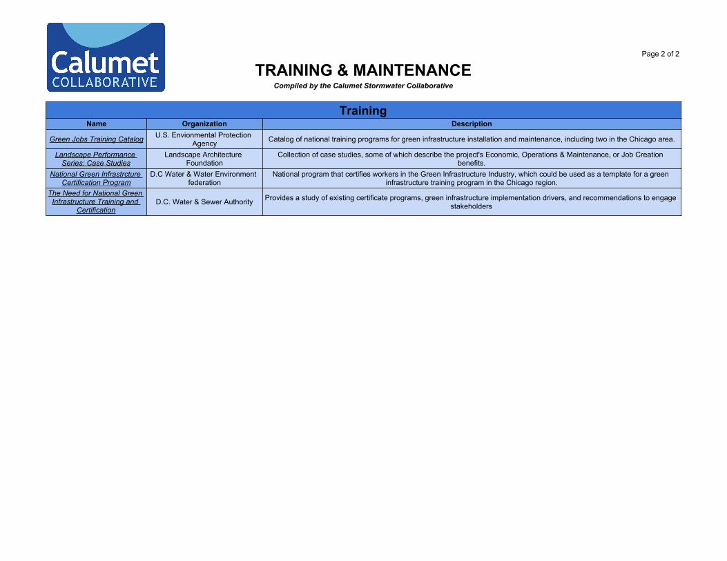
TrainingName Organization Description
Green Jobs Training Catalog U.S. Envionmental ProtectionAgency Catalog of national training programs for green infrastructure installation and maintenance, including two in the Chicago area.
Landscape Performance Series: Case Studies
Landscape Architecture Foundation
Collection of case studies, some of which describe the project's Economic, Operations & Maintenance, or Job Creation benefits.
National Green Infrastrcture Certification Program
D.C Water & Water Environmentfederation
National program that certifies workers in the Green Infrastructure Industry, which could be used as a template for a green infrastructure training program in the Chicago region.
The Need for National Green Infrastructure Training and
CertificationD.C. Water & Sewer Authority Provides a study of existing certificate programs, green infrastructure implementation drivers, and recommendations to engage