21
1 Data Collection Report – Yadkin-Pee Dee and Lumber River Basins February 2021
1
Data Collection Report –
Yadkin-Pee Dee and Lumber
River Basins
February 2021

NC Division of Water Resources
Data Collection Report – Yadkin-Pee Dee and Lumber River Basins
2
Table of Contents
Section Page
1 – Introduction 3
2 – Agricultural Water Use Data 4
3 – Municipal and Industrial Water Use Data 9
4 – Municipal and Industrial Discharge Data 11
5 – Reservoir Operations Data 12
Appendices A – Water Withdrawal and Discharge Entities 14

NC Division of Water Resources
Data Collection Report – Yadkin-Pee Dee and Lumber River Basins
3
Section 1. Introduction
The North Carolina Division of Water Resources (DWR) contracted with Hazen to develop an
OASIS model of the Yadkin-Pee Dee and Lumber River Basins. As part of that effort, Hazen
collected impairment data on water withdrawals, water discharges, and reservoir operations to
support the development of the inflows and the associated simulation run of current basin-wide
operations. The objective of the data collection effort was to provide impairment data that
spanned the hydrologic period from 1930 to 2018, the most recent year for which all impairment
data were available. This report summarizes the data collection effort. This effort has been
consistent with previous OASIS models developed for the state, including the Tar, Broad, Cape
Fear, Neuse, Roanoke, French Broad, New, and Watauga river basins. Prior data collection has
been done by other consultants, including Moffatt and Nichol and HDR, and this report
summarizes the key methodological assumptions used in all these past studies.
The objective of the data collection effort is twofold. First, to unregulate or unimpair the historic
streamflow gaging records so that the historic inflows are not influenced by past operations.
This allows the modeler and policy makers to evaluate the impacts of alternative basin-wide
operations. Second, to develop a basecase scenario for current system operations, which would
include the current level of water use and wastewater returns in the basins. For consistency,
Hazen compared and successfully matched its current estimates with those from HDR that were
prepared for the Yadkin-Pee Dee Water Management Group as part of the projection of water
needs in the Yadkin-Pee Dee (YPDWMG Long Range Water Demand Projection Updates TM_
final, HDR, July 2019). This analysis was done on a sub-basin level in the Yadkin-Pee Dee
corresponding to each of the mainstem reservoirs (from the headwaters of the basin down to Kerr
Scott, then High Rock, Tuckertown, and so on downstream beyond Blewett Falls to the North
Carolina/South Carolina border). The only key difference with the HDR study is in the
agricultural water use estimation, in which HDR used a simplified approach based on USGS
data. The method we used, as described below, is consistent with past OASIS data collection
efforts using agricultural census data and rainfall-dependent calculations. Subsequent
comparisons between the two approaches showed good overall agreement.
The summary of the data collection process was provided as a slide deck to the Technical
Review Committee (TRC_Meeting_1_Sept_01_2020.pptx, Sept. 2020 and Inflow
Development_TRC Meeting 1.pptx, Oct. 2020)

NC Division of Water Resources
Data Collection Report – Yadkin-Pee Dee and Lumber River Basins
4
Section 2. Agricultural Water Use Data
The Department of Agriculture (National Agricultural Statistics Service) publishes census data at
the federal, state, and county level every five years back to 1930. Additionally, there are surveys
conducted on a more frequent basis, but these have been shown in previous data collection
efforts by Moffatt and Nichol to be less reliable than the census data.
There are over 35 counties in the two basins combined, a few of which are in Virginia and South
Carolina. Part or all of the county drains into the basins, so we mapped the basins and allocated
the percent area of each county in the basin to estimate the amount of agriculture water use in the
basins. Additional adjustments were made as follows. In general, we assumed water use was
uniformly distributed in the county; however, if input from extension agents or other sources
suggested otherwise, we would adjust that assumption. An example is golf in Moore County
(Pinehurst), which is concentrated in the part that lies in the Lumber basin. The second
adjustment was for the ground and surface water contributions to the irrigation. The focus of the
data collection is on surface water since the stream gages that are being unregulated measure
surface water. We relied on companion USGS water use reports, published every 5 years since
the mid-1980s, to estimate the breakdown between ground and surface water use in each basin.
The census reports provide detailed information on cropping patterns (including acreage for
irrigated and non-irrigated lands) as well as livestock counts. The level of detail, both in terms
of crops and livestock, have increased over time. Electronic census data are only available since
1997, so these were downloaded into spreadsheets. Prior to then, available scanned reports were
used to identify trends using select years, including 1930 and 1969, as beginning and
intermediate points in the 90+ year inflow record from 1930 to present. These data are
summarized in the spreadsheet called “Ag summary by county_by census year.xlsx”.
From this spreadsheet, for each county, we interpolated linearly to estimate water use between
these years. These summaries for each county are captured in the spreadsheets called “Ag
summary by county_[county name].xlsx” and span the inflow record. The allocation in this
file between surface and ground water irrigation is based on the spreadsheet called “summary of
USGS data for state and county for 2015 and county for all years.xlsx”.
In general, irrigation was limited prior to the 1950s. The increased availability of lighter weight
pipe and technical developments like pivot irrigation soon followed, making irrigation more
accessible for larger areas of land. Irrigation basin-wide, however, as a percentage of all the land
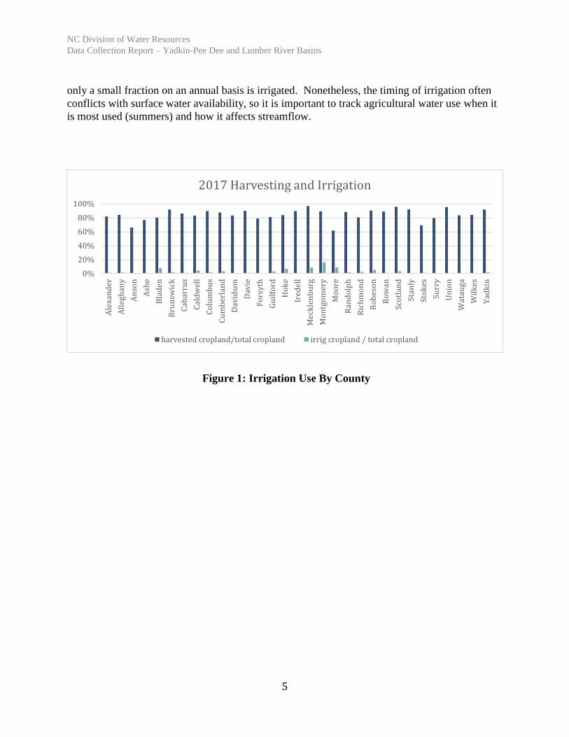
that is cropped tends to be fairly low. This is shown in Figure 1 for all the North Carolina
counties in the two basins based on the 2017 census. Of the land that is cropped and harvested,
NC Division of Water Resources
Data Collection Report – Yadkin-Pee Dee and Lumber River Basins
5
only a small fraction on an annual basis is irrigated. Nonetheless, the timing of irrigation often
conflicts with surface water availability, so it is important to track agricultural water use when it
is most used (summers) and how it affects streamflow.
Figure 1: Irrigation Use By County
0%
20%
40%
60%
80%
100%
Ale
xan
der
All
egh
any
An
son
Ash
e
Bla
den
Bru
nsw
ick
Cab
arru
s
Cal
dw
ell
Co
lum
bu
s
Cu
mb
erla
nd
Dav
idso
n
Dav
ie
Fo
rsy
th
Gu
ilfo
rd
Ho
ke
Ired
ell
Mec
kle
nb
urg
Mo
ntg
om
ery
Mo
ore
Ran
do
lph
Ric
hm
on
d
Ro
bes
on
Ro
wan
Sco
tlan
d
Stan
ly
Sto
kes
Surr
y
Un
ion
Wat
auga
Wil
kes
Yad
kin
2017 Harvesting and Irrigation
harvested cropland/total cropland irrig cropland / total cropland

NC Division of Water Resources
Data Collection Report – Yadkin-Pee Dee and Lumber River Basins
6
Consistent with other OASIS models, it is assumed that some crops like fruits are irrigated with a
fixed water amount (dependent on time of year) regardless of rainfall, while others like wheat,
corn, and cotton account for rainfall. For these crops, water use requirements (using the crop’s
evapotranspiration curves) are compared to the weekly rainfall and should there be a rainfall
deficit, then irrigation makes up the difference. Precipitation records for the historical period
from 1930 to present were collected by Hazen based on multiple stations throughout the basin
that operated for part or all of this time.
As with previous efforts, we also account for cropping patterns throughout the year. For
example, corn is assumed to be planted in mid-April in these basins and harvested in mid-
October. The water use requirement peaks in June. The crops with rainfall-dependent irrigation
are shown in Figure 2 with their ET curves.
Figure 2: Crop Water Requirements By Crop
As mentioned, the amount allocated to irrigation from surface water and ground water is
identified for each county. The total demand for crop irrigation surface water use is the number
of acres of land draining to the basin times the irrigation need times the percentage of surface
water used.
The total demand for livestock irrigation surface water use (including cattle, poultry, and pigs) is
the count of livestock in the county draining to the basin times the irrigation need times the
percentage of surface water used. Irrigation need for livestock is based on animal water use
0.00
0.05
0.10
0.15
0.20
0.25
0.30
1/1 2/1 3/1 4/1 5/1 6/1 7/1 8/1 9/1 10/1 11/1 12/1
Crop water requirements, in inches per day
Tobacco Early Soy Late Soy Peanuts Cotton Corn

NC Division of Water Resources
Data Collection Report – Yadkin-Pee Dee and Lumber River Basins
7
requirements. These water use requirements are fixed year round; for example, dairy cattle are
assumed to use 40 gallons per day per head.
Crop and livestock water use requirements (evapotranspiration curves) rely on those estimates
from prior OASIS data collection efforts, modified as needed for planting start and end dates that
vary based on regional climate differences. Also, assumptions were made consistent with
previous reports on when irrigation use started. For example, it is assumed that there was no
irrigation of tobacco prior to 1950. These assumptions are detailed in prior basin model reports,
including the Broad River Basin and Tar River Basins by Moffatt and Nichol (e.g.,
“01_TRBM_Agri_Data_Report_M&N_01-31-2011.pdf” for the Tar) and one for the French
Broad, New, and Watauga by HDR called
“01_FBRHM&NWRHM_AgIrrig_Data_HDR_Final_Report_20181108.pdf”.
The summary of agricultural water use for crops and livestock (surface water irrigation) in each
county is summarized in the previously-referenced spreadsheet called
“Ag_Use_Calculations_By_County_1929_present.xlsx”.
This county surface water use is then allocated to the basin based on the percent of land in the
basin, again generally assuming equal distribution of agriculture throughout the basin. For
consistency, the allocation percentage matches those used in the HDR water use projections
study for the Yadkin-Pee Dee (refer to the memo described earlier), in which the water use for
agriculture is assigned to the subbasins identified by HDR, starting upstream at Kerr Scott and
ending downstream of Blewett Falls.
This allocation from the county level to the subbasin level is done in the OASIS model run in the
OCL file called Agric_Allocation.ocl. As an example, agriculture water use in the Tillery
Reservoir sub-basin is set at 7% of the Davidson County demand, 20% of the Montgomery
County demand, 36% of the Randolph County demand, and 18% of the Stanly County demand.
A geographical view of the county and basin-wide allocation for both the Yadkin-Pee Dee and
Lumber basins is shown in Figure 3.

NC Division of Water Resources
Data Collection Report – Yadkin-Pee Dee and Lumber River Basins
8
Figure 3: Allocation of Water Use By County in North Carolina to Sub-Basins

NC Division of Water Resources
Data Collection Report – Yadkin-Pee Dee and Lumber River Basins
9
Section 3. Municipal and Industrial Water Use Data
DWR provided Hazen with various databases, including the Local Water Supply Plan
(LWSP) database for the municipal entities and the Water Registration (WWATR) database
for the industrial entities. The entities used in the model are limited to those that withdraw
surface water on an average day basis of 100,000 gallons per day (0.1 mgd) or more.
Exceptions are made for those with seasonal withdrawals that meet this threshold, but those
entities tend to be few in number.
The LWSPs provide monthly data every five years of surface water use starting in 1997, then
every year starting in 2007 when annual reporting became a requirement. The WWATR
database provides monthly water use data starting in 1999. LWSPs provided particularly
valuable information on how much of that water consisted of a withdrawal from the river and
how much was purchased from other systems. For inflow development, we are interested in
how much water was withdrawn from the river upstream of a gage; that amount would then
be added back to the gage flow to estimate the “natural” or unimpaired flow at the gage. We
used the purchase information to help with the model basecase run development in which we
track both withdrawals and transfers (sales/purchases) between systems.
We filled in gaps in the datasets using linear interpolation. In order to unregulate streamflows
prior to these years, we “hindcasted” the annual water use for these entities. This was done
based on population (at the county or local level) for the public water suppliers and on GDP
(at the industry level) for the industrial withdrawals. We converted the annual hindcasts to
monthly estimates by applying a monthly pattern derived from the years of available data.
We factored in start and stop dates for the facilities to accurately represent the timing of the
surface water withdrawal. For example, if a utility only began withdrawing surface water in
the 1980s and prior to that was reliant on groundwater, the hindcast of surface water
withdrawal would only extend back to the 1980s. A sample hindcast is shown in Figure 4 for
the city of Concord’s surface water withdrawal from Coddle Creek:

NC Division of Water Resources
Data Collection Report – Yadkin-Pee Dee and Lumber River Basins
10
Figure 4: Sample Hindcast of Municipal Surface Water Withdrawals
We also reached out to the utilities directly as needed to confirm or supplement the data in
the databases, including facility operational dates. These data are ultimately captured in the
inflow development files (detailed in Hazen, 2020, Appendix B - Finalized Inflow Data
Development.docx) which capture the gaging data, the impairment data, and the resulting
unimpairment of the gaging data for the 1930 to present inflow record.
Appendix A in this document provides the entities that are included in the inflow
unimpairment and model development process.

NC Division of Water Resources
Data Collection Report – Yadkin-Pee Dee and Lumber River Basins
11
Section 4. Municipal and Industrial Discharge Data
DWR also provided Hazen with the NPDES database which captures all water dischargers,
including wastewater, water treatment plant process water, and stormwater. As mentioned,
the threshold used in the inflow and model development is 0.1 mgd, with consideration for
seasonal dischargers. The database provided us with at least monthly data since the mid-
1990s. Supplemental data from entities was used as needed, including information from the
LWSP database for public entities. Many of the dischargers included in the analysis do not
have a companion surface water withdrawal (instead they draw on ground water or purchase
water), but they are included in the inflow and model development since they are discharging
to the surface water. Some of the dischargers are regional entities, collecting wastewater
from multiple systems, like Anson County and the Water and Sewer Authority of Cabarrus
County (WSACC).
For inflow development, we are interested in how much water is returned upstream of a gage;
that amount would then be subtracted from the gage flow to estimate the “natural” or
unimpaired flow at the gage. Hindcasting followed the same approach as with the
withdrawals, using either population data for the municipal discharges or GDP for the
industrial discharges, and adjusted for facility operational dates.
For consistency with HDR’s basin-wide water use projections report referenced earlier, we
treated the power plant withdrawals as a net withdrawal – that is, withdrawal less
discharge—since the two are assumed to be in close proximity.
.
These data are contained in the inflow development spreadsheets mentioned above.
Appendix A in this document provides the entities that are included in the inflow
unimpairment and model development process.
NC Division of Water Resources
Data Collection Report – Yadkin-Pee Dee and Lumber River Basins
12
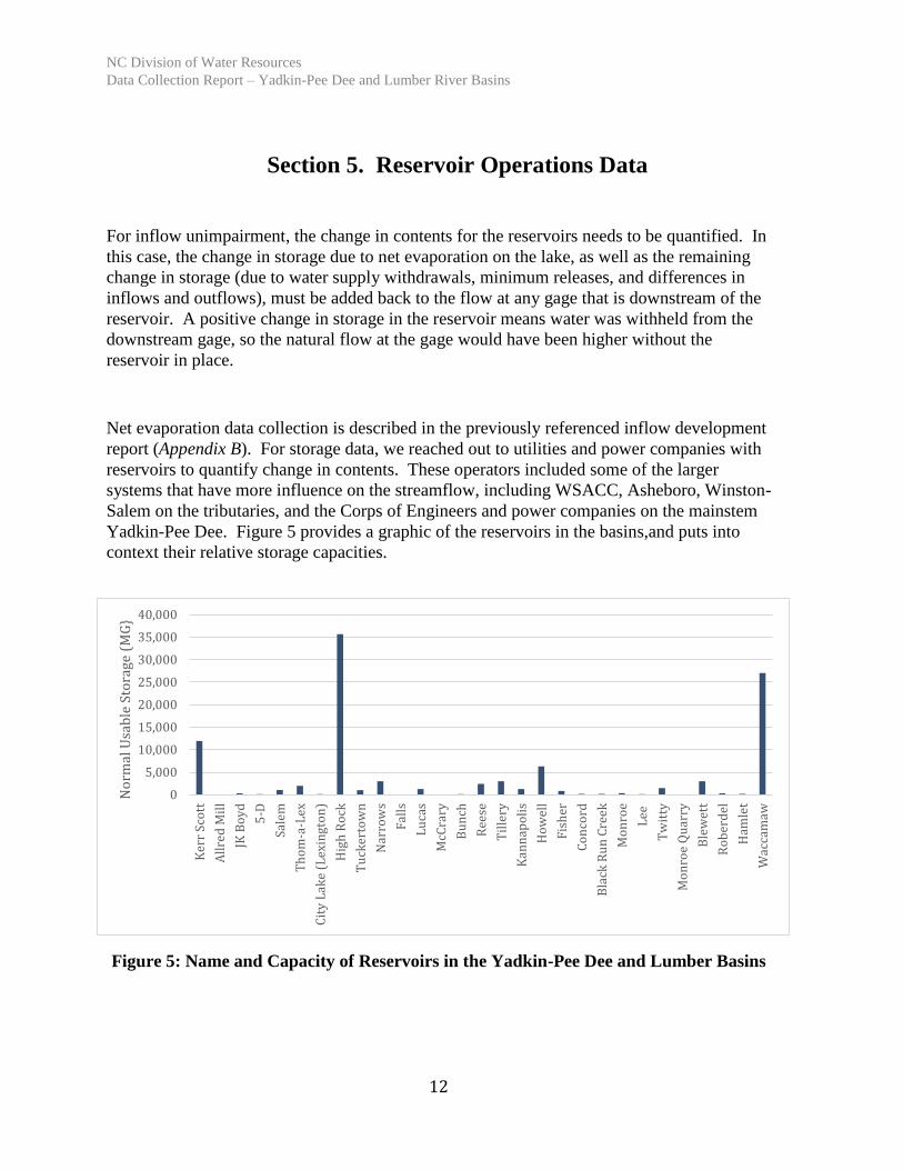
Section 5. Reservoir Operations Data
For inflow unimpairment, the change in contents for the reservoirs needs to be quantified. In
this case, the change in storage due to net evaporation on the lake, as well as the remaining
change in storage (due to water supply withdrawals, minimum releases, and differences in
inflows and outflows), must be added back to the flow at any gage that is downstream of the
reservoir. A positive change in storage in the reservoir means water was withheld from the
downstream gage, so the natural flow at the gage would have been higher without the
reservoir in place.
Net evaporation data collection is described in the previously referenced inflow development
report (Appendix B). For storage data, we reached out to utilities and power companies with
reservoirs to quantify change in contents. These operators included some of the larger
systems that have more influence on the streamflow, including WSACC, Asheboro, Winston-
Salem on the tributaries, and the Corps of Engineers and power companies on the mainstem
Yadkin-Pee Dee. Figure 5 provides a graphic of the reservoirs in the basins,and puts into
context their relative storage capacities.
Figure 5: Name and Capacity of Reservoirs in the Yadkin-Pee Dee and Lumber Basins
0
5,000
10,000
15,000
20,000
25,000
30,000
35,000
40,000
Ker
r S
cott
All
red
Mil
l
JK B
oy
d
5-D
Sale
m
Th
om
-a-L
ex
Cit
y L
ake
(Lex
ingt
on
)
Hig
h R
ock
Tu
cker
tow
n
Nar
row
s
Fal
ls
Lu
cas
McC
rary
Bu
nch
Ree
se
Til
lery
Kan
nap
oli
s
Ho
wel
l
Fis
her
Co
nco
rd
Bla
ck R
un
Cre
ek
Mo
nro
e
Lee
Tw
itty
Mo
nro
e Q
uar
ry
Ble
wet
t
Ro
ber
del
Ham
let
Wac
cam
aw
No
rmal
Usa
ble
Sto
rage
(M
G}

NC Division of Water Resources
Data Collection Report – Yadkin-Pee Dee and Lumber River Basins
13
The critical data apply to the mainstem Yadkin projects given the high level of streamflow
regulation. Kerr Scott data are available electronically from the Corps of Engineers website.
Cube Carolinas and Duke Energy were able to provide electronic data on reservoir operations
from 2000 to present. Prior to this, we were able to retrieve historic monthly change in
contents data as published in the USGS water use reports (see sample in Figure 6 below).
These data allowed us to unimpair a number of long-term mainstem gages, including the
Yadkin College and Rockingham gages on the Yadkin River.
Figure 6: USGS Water Data Reports Showing Monthly Reservoir Contents
The reservoir impairment data are included in the inflow development files as described
earlier.

NC Division of Water Resources
Data Collection Report – Yadkin-Pee Dee and Lumber River Basins
14
Appendix A - Water Withdrawal and Discharge Entities

NC Division of Water Resources
Data Collection Report – Yadkin-Pee Dee and Lumber River Basins
15
Table A-1. Municipal withdrawals (LWSP) used for inflow unimpairment and model development
Water System PWSID County OASIS Node #
OASIS Node Name OASIS WD Arc #
OASIS WD Arc Name
Albemarle 01-84-010 Stanly 625 Albermarle 01-84-010 610.622 Albemarle Jack F Neel WD
Albemarle 01-84-010 Stanly 625 Albermarle 01-84-010 640.622 Albemarle US 52 HWY WD
Anson Co 03-04-010 Anson 975 Anson Co. 03-04-010 920.966 Anson WD
Asheboro 02-76-010 Randolph 685 Asheboro 02-76-010 690.685 Asheboro Lake Bunch WD
Asheboro 02-76-010 Randolph 685 Asheboro 02-76-010 670.685 Asheboro Lake Lucas WD
Asheboro 02-76-010 Randolph 685 Asheboro 02-76-010 680.685 Asheboro Lake Reese WD
Concord 01-13-010 Cabarrus 785 Concord 01-13-010 770.779 Concord Coddle Ck WD
Concord 01-13-010 Cabarrus 785 Concord 01-13-010 780.779 Concord Hillgrove WD (Lake Fisher)
Concord 01-13-010 Cabarrus 785 Concord 01-13-010 790.779 Concord Hillgrove WD (Lake Concord)
Davidson Water 02-29-025 Davidson 425 Davidson Water 02-29-025 400.419 Davidson Water WD
Davie Co 02-30-015 Davie 375 Davie County 02-30-015 305.366 Davie Co Cooleemee WD
Davie Co 02-30-015 Davie 375 Davie County 02-30-015 365.366 Davie Co Sparks Rd WD
Denton 02-29-030 Davidson 615 Denton 02-29-030 605.615 Denton WD
Dobson 02-86-030 Surry 135 Dobson 02-86-030 130.135 Dobson WD
Elkin 02-86-020 Surry 75 Elkin 02-86-020 80.75 Elkin WD
Energy United Water 01-02-015 Alexander n/a Not included - inactive n/a n/a
Hamlet Water System 03-77-010 Richmond 985 Hamlet 03-77-010 980.982 Hamlet WD
Jonesville 02-99-010 Yadkin 115 Jonesville 02-99-010 100.115 Jonesville WD
Kannapolis 01-80-065 Rowan 775 Kannapolis 01-80-065 760.771 Kannapolis - Kann. Lake WD
Kannapolis 01-80-065 Rowan 775 Kannapolis 01-80-065 320.771 Kannapolis Back Ck WD
Kannapolis 01-80-065 Rowan 775 Kannapolis 01-80-065 770.771 Kannapolis Lake Howell WD
King 02-85-010 Stokes 345 King 02-85-010 340.345 King WD
Landis 01-80-038 Rowan n/a Not included - inactive n/a n/a
Lexington 02-29-010 Davidson 565 Lexington 02-29-010 560.565 Lake Thom-A-Lex WD
Lumberton 03-78-010 Robeson 1315 Lumberton 03-78-010 1300.1312 Lumberton WD
Mocksville 02-30-010 Davie 295 Mocksville 02-30-010 276.295 Mocksville WD

NC Division of Water Resources
Data Collection Report – Yadkin-Pee Dee and Lumber River Basins
16
Water System PWSID County OASIS Node #
OASIS Node Name OASIS WD Arc #
OASIS WD Arc Name
Monroe 01-90-010 Union 855 Monroe 01-90-010 860.849 Monroe Lake Twitty WD
Montgomery Co 03-62-010 Montgomery 705 Montgomery 03-62-010 700.705 Montgomery WD
Mount Airy 02-86-010 Surry 185 Mt Airy 02-86-010 180.185 Mt. Airy F.G. Dogget WD
Mount Airy 02-86-010 Surry 185 Mt Airy 02-86-010 170.185 Mt. Airy S.L. Spencer WD
Mt. Pleasant 01-13-020 Cabarrus 825 Mount Pleasant 01-13-020 826.825 Mount Pleasant Dutch Buffalo Ck WD
North Wilkesboro 01-97-010 Wilkes 35 North Wilkesboro 01-97-010 30.35 North Wilkesboro WD
Norwood 01-84-015 Stanly 715 Norwood 01-84-015 700.715 Norwood WD
Pilot Mountain 02-86-025 Surry 205 Pilot Moutain 02-86-025 190.205 Pilot Mountain WD
Richmond County 03-77-109 Richmond 925 Richmond Co. 03-77-109 920.924 Richmond WD
Rockingham 03-77-015 Richmond 955 Rockingham 03-77-015 960.952 Rockingham City Pond WD
Rockingham 03-77-015 Richmond 955 Rockingham 03-77-015 950.952 Rockingham Roberdel Lake WD
Salisbury 01-80-010 Rowan 465 Salisbury 01-80-010 450.462 Salisbury WD
Southern Pines 03-63-010 Moore 1025 Southern Pines 03-63-010 1014.1025 Southern Pines WD
Statesville 01-49-010 Iredell 255 Statesville 01-49-010 250.255 Statesville WD
Thomasville 02-29-020 Davidson 555 Thomasville 02-29-020 560.555 Thomasville WD
Wadesboro 03-04-020 Anson 965 Wadesboro 03-04-020 970.956 Wadesboro WD
Wilkesboro 01-97-025 Wilkes 25 Wilkesboro 01-97-025 20.22 Wilkesboro WD
Winston-Salem 02-34-010 Forsyth 395 Winston Salem 02-34-010 385.389 Winston Salem Yadkin Idols Dam WD
Winston-Salem 02-34-010 Forsyth 395 Winston Salem 02-34-010 341.389 Winston Salem Yadkin Swann Dam WD
Winston-Salem 02-34-010 Forsyth 395 Winston Salem 02-34-010 380.389 Winston Salem Salem Lake WD
Yadkinville 02-99-015 Yadkin 355 Yadkinville 02-99-015 354.355 Yadkinville WD

NC Division of Water Resources
Data Collection Report – Yadkin-Pee Dee and Lumber River Basins
17
Table A-2. Industrial withdrawals (WWATR) used for inflow unimpairment and model development
OWNER FACILITY ID County OASIS Node #
OASIS Node Name
APAC Candor Sand Plant 0865-0001 Montgomery 1005 APAC Candor Sand Plant 0865-0001
ATI Allvac Monroe Plant 0338-0001 Union 875 ATI Allvac Demand 0338-0001
Blue Ridge Tissue Corp Blue Ridge Tissue Corp - Patterson Mill 0786-0001 Caldwell 5 Blue Ridge Patterson Mill 0786-0001
BV Hedrick Aquadale Plant 0356-0003 Stanly 885 Hedrick Aquadale Quarry 0356-0003
BV Hedrick Hedrick Mine 0420-0003 Anson 945 Hedrick G&S Mine 0420-0003
BV Hedrick Norman Sand Company 0356-0004 Montgomery 915 Hedrick Norman Sand Co Demand 0356-0004
Cascades West Point Home Filter/Waste Treatment
0095-0001 Scotland 1055 Cascades Wagram Plant 0095-0001
Covia Marston Facility 0194-0004 Richmond 1205 Covia Marston Facility 0194-0004
Duke Energy Weatherspoon Steam Electric Power Plant
0033-0010 Robeson 1325 Duke Weatherspoon Plant 0033-0010
Duke Energy Buck Combined Cycle Station 0057-0021 Rowan 525 Duke Energy - Buck Comb. Cycle Station 0057-0021
Duke Energy Buck Steam Station 0057-0011 Rowan n/a Not included - inactive last 5 yrs
Durafiber Technologies
Durafiber Technologies - Salisbury 0841-0001 Rowan n/a Not included - inactive - combine w/ Performance Fibers 0383-0002 for hindcast/UIF
Flowe Farms 2 LLC Flowe Farms 2 LLC 0838-0001 Cabarrus 845 Flowe Farms 0838-0001
Interface, Inc. Interface, Inc. 0422-0001 Surry n/a Not included - inactive last 5 yrs
Invista, Sarl Invista, Sarl 0358-0001 Rowan n/a Not included - inactive last 5 yrs
Louisiana Pacific Corporation
Louisiana Pacific Corporation 0001-0001 Wilkes 55 Louisiana Pacific 0001-0001
Performance Fibers, Inc.
Performance Fibers - Salisbury Facility 0383-0002 Rowan n/a combined w/ Durafiber 0841-0001 for hindcast/UIF
The Fork LLC The Fork, LLC 0007-0001 Stanly 905 The Fork Farm & Stables 0007-0001
True Textiles, Inc. True Elkin, Inc. 0705-0001 Surry 65 True Textiles Elkin 0705-0001

NC Division of Water Resources
Data Collection Report – Yadkin-Pee Dee and Lumber River Basins
18
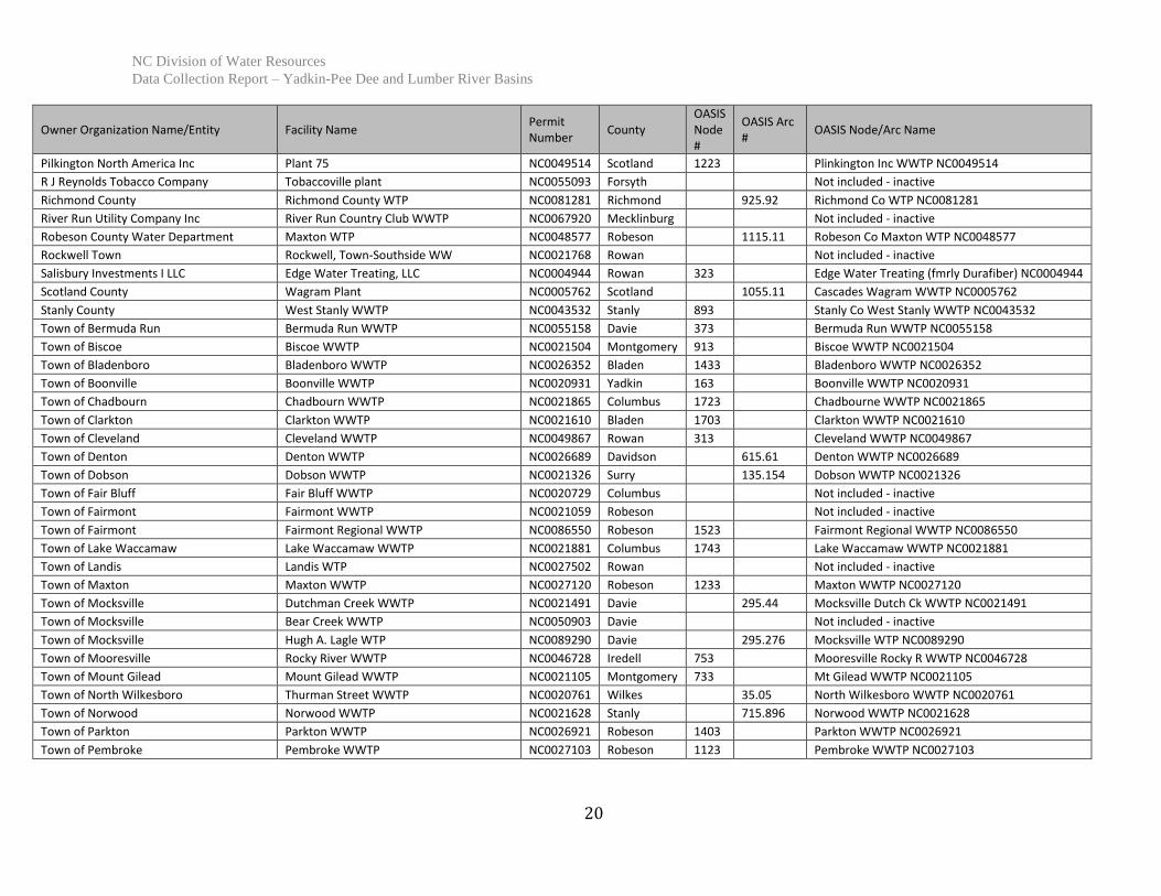
Table A-3. Municipal and Industrial Discharges (NPDES) used for inflow unimpairment and model development
Owner Organization Name/Entity Facility Name Permit Number
County OASIS Node #
OASIS Arc #
OASIS Node/Arc Name
Allegheny Technologies Inc ATI Specialty Materials - Monroe Plant NC0045993 Union 875.857 ATI Allvac WWTP NC0045993
Anson County Anson County Regional WWTP NC0041408 Anson 973 Anson Co. Regional WWTP NC0041408
Anson County Anson County WTP NC0074390 Anson 975.92 Anson Co. WTP NC0074390
Aqua North Carolina Inc Country Wood WWTP NC0065684 Union 853 AquaNC Country Wood WWTP NC0065684
B V Hedrick Gravel & Sand Company Aquadale Quarry NC0028169 Stanly 885.88 Hendrick Aquadale Quarry WW NC0028169
Badin Business Park LLC Badin Business Park NC0004308 Stanly 653 Badin Business Park WW NC0004308
Blue Ridge Tissue Corporation Patterson Mill NC0006254 Caldwell 5 Blue Ridge Patterson Mill 0786-0001
Boyle Company John Boyle & Company (John) NC0005282 Iredell Not included - inactive
Brunswick County Carolina Shores WWTP NC0044873 Brunswick 1773 Carolina Shores WWTP NC0044873
Burlington Industries LLC Richmond Plant NC0043320 Richmond 963 Burlington Ind WW NC0043320
Carolina Mirror Company LLC Carolina Mirror WWTP NC0006696 Wilkes Not included - inactive
Carolina Stalite Company Carolina Stalite Company NC0080586 Rowan 823 Carolina Stalite Co WW NC0080586
Carolina Water Service Inc of NC Hemby Acres WWTP NC0035041 Union 873 Carolina WS - Hemby WWTP NC0035041
Carolina Water Service Inc of NC Bradfield Farms WWTP NC0064734 Cabarrus 813 Carolina WS - Bradfield Farms WWTP NC0064734
Charlotte Water Mallard Creek WWTP NC0030210 Mecklenburg 763 Charlottle Mallard Creek WWTP NC0030210
City of Albemarle Long Creek WWTP NC0024244 Stanly 625.836 Albemarle WWTP NC0024244
City of Albemarle Highway 52 WTP NC0044024 Stanly 625.64 Albemarle Hwy 52 WTP NC0044024
City of Albemarle Tuckertown WTP NC0075701 Stanly 625.61 Albemarle Tuckertown WTP NC0075701
City of Charlotte Cabarrus Woods WWTP NC0035033 Mecklinburg 803 Charlotte Cabarrus Woods WWTP NC0035033
City of Concord Coddle Creek WTP NC0083119 Cabarrus 785.784 Concord Coddle Ck WTP NC0083119
City of Hamlet Hamlet WWTP NC0047562 Richmond 985.983 Hamlet WWTP NC0047562
City of High Point Westside WWTP NC0024228 Davidson 573 High Point Westside WWTP NC0024228
City of Kannapolis Kannapolis WTP NC0006220 Rowan 775.822 Kannapolis WTP NC0006220
City of King King WTP NC0088897 Forsyth 345.34 King WTP NC0088897
City of Laurinburg Leith Creek WWTP NC0020656 Scotland 1213 Laurinburg Leith Ck WWTP NC0020656
City of Lexington Lexington WTP #1 & 2 NC0028037 Davidson 565.574 Lexington WTP NC0028037
City of Lexington Lexington Regional WWTP NC0055786 Davidson 565.577 Lexington WWTP NC0055786
City of Lumberton Lumberton WWTP NC0024571 Robeson 1315.132 Lumberton WWTP NC0024571
City of Monroe Monroe WWTP NC0024333 Union 855.857 Monroe WWTP NC0024333
City of Monroe John Glenn WTP NC0080381 Union 855.86 Monroe WTP NC0080381
City of Mount Airy Mount Airy WWTP NC0021121 Surry 185.188 Mt Airy WWTP NC0021121
City of Rockingham Rockingham WWTP NC0020427 Richmond 955.962 Rockingham WWTP NC0020427

NC Division of Water Resources
Data Collection Report – Yadkin-Pee Dee and Lumber River Basins
19
Owner Organization Name/Entity Facility Name Permit Number
County OASIS Node #
OASIS Arc #
OASIS Node/Arc Name
City of Salisbury City of Salisbury WWTP NC0023884 Rowan 465.5 Salisbury WWTP NC0023884
City of Salisbury Town Creek WWTP NC0023892 Rowan Not included - inactive
City of Salisbury Sowers Ferry Road WWTP NC0025593 Rowan Not included - inactive
City of Southport Southport WWTP NC0021334 Brunswick Not included - inactive
City of Statesville Third Creek WWTP NC0020591 Iredell 255.319 Statesville Third Ck WWTP NC0020591
City of Statesville Fourth Creek WWTP NC0031836 Iredell 255.32 Statesville Fourth Ck WWTP NC0031836
City of Thomasville Hamby Creek WWTP NC0024112 Davidson 555.574 Thomasville WWTP NC0024112
City of Thomasville City of Thomasville WTP NC0088200 Davidson 555.56 Thomasville WTP NC0088200
City of Whiteville Whiteville WRF NC0021920 Columbus 1713 Whiteville WRF NC0021920
City of Winston-Salem Archie Elledge WWTP NC0037834 Forsyth 395.39 Winston Salem Archie E WWTP NC0037834
City of Winston-Salem Muddy Creek WWTP NC0050342 Forsyth 395.394 Winston Salem Mud Ck WWTP NC0050342
City of Winston-Salem R.A. Thomas WTP NC0079821 Forsyth 395.38 Winston Salem R.A. Thomas WTP NC0079821
City of Winston-Salem R.W. Neilson WTP NC0086011 Forsyth 395.385 R.W. Neilson WTP NC0086011
City of Winston-Salem P.W. Swann WTP NC0086762 Forsyth 395.341 Winston Salem P.W. Swann WTP NC0086762
Color/Tex Finishing Corp Color Tex Finishing Corporation NC0005487 Rowan Not included - inactive
Davidson Water Inc Davidson Water WTP NC0084425 Davidson 425.4 Davidson Water WTP NC0084425
Davie County Cooleemee WWTP NC0024872 Davie 375.31 Davie Co WWTP NC0024872
Davie County Sparks Road WTP NC0084212 Davie 375.365 Davie Co Sparks Rd WTP NC0084212
Duke Energy Carolinas LLC Buck Steam Station NC0004774 Rowan 525.5 Duke Combined Cycle St. WW NC0004774
Duke Energy Progress LLC Weatherspoon Steam Electric Plant NC0005363 Robeson 1325.133 Duke Weatherspoon WW NC0005363
Duvaltex US Inc Duvaltex NC0005312 Surry 65.12 Duvaltex (fmrly TrueText) WWTP NC0005312
Electric Glass Fiber America LLC PPG Industries Fiber Glass Products, Inc. NC0004626 Davidson 513 PPG WWTP NC0004626
Georgia-Pacific Wood Products LLC Whiteville Plywood Plant NC0005801 Columbus Not included - plant closed
Greater Badin Water & Sewer District Badin WWTP NC0074756 Stanly 663 Badin W&S WWTP NC0074756
Laurinburg-Maxton Airport Commission Laurinburg Industrial WWTP NC0044725 Scotland 1093 Laurinburg-Maxton Airport WWTP NC0044725
Louisiana-Pacific Corporation LP Roaring River WWTP NC0005266 Wilkes 55.06 Louisiana Pacific WWTP NC000526
Lumberton Cellulose LLC Lumberton Mill NC0005321 Robeson Not included - inactive
Lumberton Energy Holdings LLC Lumberton Energy Holdings LLC NC0004618 Robeson 1323 Lumberton Energy Holdings LLC NC0004618
Moore County Moore County WPCF NC0037508 Moore 1023 Moore County WPCF NC0037508
Mountaire Farms of North Carolina Corp Mountaire Farms - Lumber Bridge WWTF NC0040185 Robeson Not included - inactive
NC Department of Public Safety McCain Correctional Hospital WWTP NC0035904 Hoke 1033 McCain Correctional Hospital WWTP NC0035904
Norfolk Southern Railway Company Linwood Yard NC0029246 Davidson 503 Norfolk Southern WW NC0029246
North Carolina Granite Corp North Carolina Granite Corporation NC0006483 Surry Not included - inactive
NC Division of Water Resources
Data Collection Report – Yadkin-Pee Dee and Lumber River Basins
20
Owner Organization Name/Entity Facility Name Permit Number
County OASIS Node #
OASIS Arc #
OASIS Node/Arc Name
Pilkington North America Inc Plant 75 NC0049514 Scotland 1223 Plinkington Inc WWTP NC0049514
R J Reynolds Tobacco Company Tobaccoville plant NC0055093 Forsyth Not included - inactive
Richmond County Richmond County WTP NC0081281 Richmond 925.92 Richmond Co WTP NC0081281
River Run Utility Company Inc River Run Country Club WWTP NC0067920 Mecklinburg Not included - inactive
Robeson County Water Department Maxton WTP NC0048577 Robeson 1115.11 Robeson Co Maxton WTP NC0048577
Rockwell Town Rockwell, Town-Southside WW NC0021768 Rowan Not included - inactive
Salisbury Investments I LLC Edge Water Treating, LLC NC0004944 Rowan 323 Edge Water Treating (fmrly Durafiber) NC0004944
Scotland County Wagram Plant NC0005762 Scotland 1055.11 Cascades Wagram WWTP NC0005762
Stanly County West Stanly WWTP NC0043532 Stanly 893 Stanly Co West Stanly WWTP NC0043532
Town of Bermuda Run Bermuda Run WWTP NC0055158 Davie 373 Bermuda Run WWTP NC0055158
Town of Biscoe Biscoe WWTP NC0021504 Montgomery 913 Biscoe WWTP NC0021504
Town of Bladenboro Bladenboro WWTP NC0026352 Bladen 1433 Bladenboro WWTP NC0026352
Town of Boonville Boonville WWTP NC0020931 Yadkin 163 Boonville WWTP NC0020931
Town of Chadbourn Chadbourn WWTP NC0021865 Columbus 1723 Chadbourne WWTP NC0021865
Town of Clarkton Clarkton WWTP NC0021610 Bladen 1703 Clarkton WWTP NC0021610
Town of Cleveland Cleveland WWTP NC0049867 Rowan 313 Cleveland WWTP NC0049867
Town of Denton Denton WWTP NC0026689 Davidson 615.61 Denton WWTP NC0026689
Town of Dobson Dobson WWTP NC0021326 Surry 135.154 Dobson WWTP NC0021326
Town of Fair Bluff Fair Bluff WWTP NC0020729 Columbus Not included - inactive
Town of Fairmont Fairmont WWTP NC0021059 Robeson Not included - inactive
Town of Fairmont Fairmont Regional WWTP NC0086550 Robeson 1523 Fairmont Regional WWTP NC0086550
Town of Lake Waccamaw Lake Waccamaw WWTP NC0021881 Columbus 1743 Lake Waccamaw WWTP NC0021881
Town of Landis Landis WTP NC0027502 Rowan Not included - inactive
Town of Maxton Maxton WWTP NC0027120 Robeson 1233 Maxton WWTP NC0027120
Town of Mocksville Dutchman Creek WWTP NC0021491 Davie 295.44 Mocksville Dutch Ck WWTP NC0021491
Town of Mocksville Bear Creek WWTP NC0050903 Davie Not included - inactive
Town of Mocksville Hugh A. Lagle WTP NC0089290 Davie 295.276 Mocksville WTP NC0089290
Town of Mooresville Rocky River WWTP NC0046728 Iredell 753 Mooresville Rocky R WWTP NC0046728
Town of Mount Gilead Mount Gilead WWTP NC0021105 Montgomery 733 Mt Gilead WWTP NC0021105
Town of North Wilkesboro Thurman Street WWTP NC0020761 Wilkes 35.05 North Wilkesboro WWTP NC0020761
Town of Norwood Norwood WWTP NC0021628 Stanly 715.896 Norwood WWTP NC0021628
Town of Parkton Parkton WWTP NC0026921 Robeson 1403 Parkton WWTP NC0026921
Town of Pembroke Pembroke WWTP NC0027103 Robeson 1123 Pembroke WWTP NC0027103
NC Division of Water Resources
Data Collection Report – Yadkin-Pee Dee and Lumber River Basins
21
Owner Organization Name/Entity Facility Name Permit Number
County OASIS Node #
OASIS Arc #
OASIS Node/Arc Name
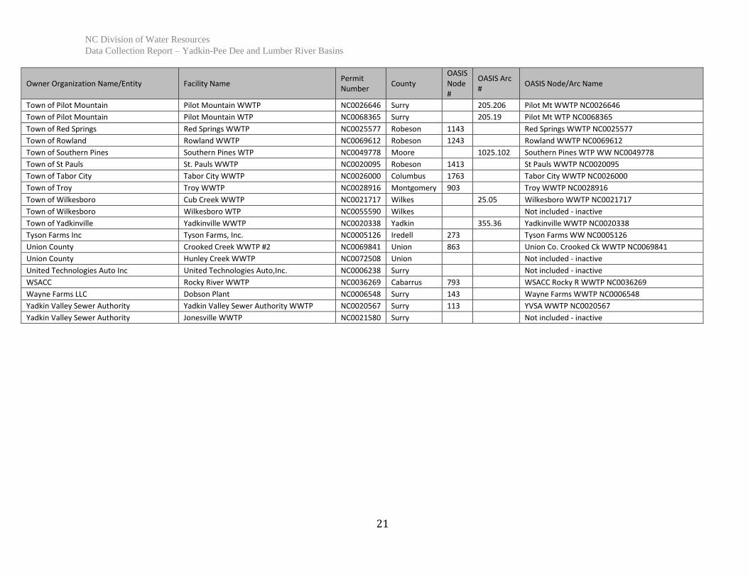
Town of Pilot Mountain Pilot Mountain WWTP NC0026646 Surry 205.206 Pilot Mt WWTP NC0026646
Town of Pilot Mountain Pilot Mountain WTP NC0068365 Surry 205.19 Pilot Mt WTP NC0068365
Town of Red Springs Red Springs WWTP NC0025577 Robeson 1143 Red Springs WWTP NC0025577
Town of Rowland Rowland WWTP NC0069612 Robeson 1243 Rowland WWTP NC0069612
Town of Southern Pines Southern Pines WTP NC0049778 Moore 1025.102 Southern Pines WTP WW NC0049778
Town of St Pauls St. Pauls WWTP NC0020095 Robeson 1413 St Pauls WWTP NC0020095
Town of Tabor City Tabor City WWTP NC0026000 Columbus 1763 Tabor City WWTP NC0026000
Town of Troy Troy WWTP NC0028916 Montgomery 903 Troy WWTP NC0028916
Town of Wilkesboro Cub Creek WWTP NC0021717 Wilkes 25.05 Wilkesboro WWTP NC0021717
Town of Wilkesboro Wilkesboro WTP NC0055590 Wilkes Not included - inactive
Town of Yadkinville Yadkinville WWTP NC0020338 Yadkin 355.36 Yadkinville WWTP NC0020338
Tyson Farms Inc Tyson Farms, Inc. NC0005126 Iredell 273 Tyson Farms WW NC0005126
Union County Crooked Creek WWTP #2 NC0069841 Union 863 Union Co. Crooked Ck WWTP NC0069841
Union County Hunley Creek WWTP NC0072508 Union Not included - inactive
United Technologies Auto Inc United Technologies Auto,Inc. NC0006238 Surry Not included - inactive
WSACC Rocky River WWTP NC0036269 Cabarrus 793 WSACC Rocky R WWTP NC0036269
Wayne Farms LLC Dobson Plant NC0006548 Surry 143 Wayne Farms WWTP NC0006548
Yadkin Valley Sewer Authority Yadkin Valley Sewer Authority WWTP NC0020567 Surry 113 YVSA WWTP NC0020567
Yadkin Valley Sewer Authority Jonesville WWTP NC0021580 Surry Not included - inactive


