Macroscale Modelling of the Hydrosphere (Proceedings of the Yokohama Symposium, July 1993). IAHSPubl.no. 214,103. 139 Data requirements for macroscale modelling of the hydrosphere NIGEL W. ARNELL Institute of Hydrology, Wallingford, Oxfordshire OX10 8BB, UK Abstract The paper provides a review of the data requirements of macroscale hydrological models. Data are needed for model development, model operation and model validation. Highly detailed data are required for model development, whilst model operation requires data over a very large spatial domain; ideally, this domain is the entire world. The need for data over such a large region places severe constraints on the development of macroscale hydrological models. A compromize needs to be made between using enough parameters to ensure that physical processes are represented realistically, and using just those parameters which can be determined reliably from global or continental data sets. INTRODUCTION Macroscale models of the hydrosphere are designed to simulate components of the hydrological cycle at scales up to that of a continent. The aims of this paper are to define the data needed for such macromodels, and to summarize the data that currently exist. There are several major programs concerned with macroscale hydrological modelling. The WMO GEWEX Continental Scale International Project (GCIP) has the development of such models as one of its objectives using, in the first instance, data from the Mississippi Basin. The IGBP Biospheric Aspects of the Hydrological Cycle (BAHC) project is concerned with the inclusion of vegetation characteristics and dynamics in continental scale hydrological models. In the United Kingdom, the Natural Environment Research Council TIGER programme (Terrestrial Initiative in Global Environmental Research) is supporting a coordinated investigation into macroscale modelling and associated data requirements, involving researchers from the Institute of Hydrology, Imperial College of Science and Technology, London, the University of Newcastle-upon-Tyne, and University College, London. This paper benefits from experiences gained both during participation in GCIP science committees and through macroscale modelling studies at the Institute of Hydrology for the TIGER project. MACROSCALE MODELLING In the most general sense, macroscale hydrological modelling (or "macromodelling") is simply the application of hydrological models over a large spatial domain, ranging from a "large" basin (over 10 4 km 2 ), through a continent to the entire land surface of the globe. There are two basic reasons why hydrologists have become interested in modelling at such scales, which are well above that at which the processes of runoff generation are conventionally studied and modelled.
Transcript
Macroscale Modelling of the Hydrosphere (Proceedings of the Yokohama Symposium, July 1993). IAHSPubl.no. 214,103. 139
Data requirements for macroscale modelling of the hydrosphere
NIGEL W. ARNELL Institute of Hydrology, Wallingford, Oxfordshire OX10 8BB, UK
Abstract The paper provides a review of the data requirements of macroscale hydrological models. Data are needed for model development, model operation and model validation. Highly detailed data are required for model development, whilst model operation requires data over a very large spatial domain; ideally, this domain is the entire world. The need for data over such a large region places severe constraints on the development of macroscale hydrological models. A compromize needs to be made between using enough parameters to ensure that physical processes are represented realistically, and using just those parameters which can be determined reliably from global or continental data sets.
INTRODUCTION
Macroscale models of the hydrosphere are designed to simulate components of the hydrological cycle at scales up to that of a continent. The aims of this paper are to define the data needed for such macromodels, and to summarize the data that currently exist.
There are several major programs concerned with macroscale hydrological modelling. The WMO GEWEX Continental Scale International Project (GCIP) has the development of such models as one of its objectives using, in the first instance, data from the Mississippi Basin. The IGBP Biospheric Aspects of the Hydrological Cycle (BAHC) project is concerned with the inclusion of vegetation characteristics and dynamics in continental scale hydrological models. In the United Kingdom, the Natural Environment Research Council TIGER programme (Terrestrial Initiative in Global Environmental Research) is supporting a coordinated investigation into macroscale modelling and associated data requirements, involving researchers from the Institute of Hydrology, Imperial College of Science and Technology, London, the University of Newcastle-upon-Tyne, and University College, London. This paper benefits from experiences gained both during participation in GCIP science committees and through macroscale modelling studies at the Institute of Hydrology for the TIGER project.
MACROSCALE MODELLING
In the most general sense, macroscale hydrological modelling (or "macromodelling") is simply the application of hydrological models over a large spatial domain, ranging from a "large" basin (over 104 km2), through a continent to the entire land surface of the globe. There are two basic reasons why hydrologists have become interested in modelling at such scales, which are well above that at which the processes of runoff generation are conventionally studied and modelled.
Firstly, hydrologists have wanted to correct perceived weaknesses in the representation of hydrological processes in regional and global atmospheric models. Two areas are recognized as being particularly important, namely the explicit treatment of variability within an atmospheric model grid cell (the aggregated response of actual evaporation, for example, over all land surface properties within a grid cell may be rather different to the response of the average land surface, due to spatial variation in soil moisture) and the routing of water along a river network within and between grid cells. This routing is important because water can be imported into a grid cell, and hence provide a source for evaporation, and because the timing of freshwater inflows into the ocean affects salinity patterns, and hence currents and the rate of freezing and thawing of sea ice.
Secondly, hydrologists have developed an interest in simulating river flows in large river basins for a variety of operational and planning purposes. These include regional water resources planning, flow forecasting and estimating the implications for river flow regimes, throughout a basin, of changes in water use, land cover or climate. Such models need not be incorporated into an atmospheric model, but might be designed to be able to use "off-line" climatic data simulated by an atmospheric model.
Two different approaches to macroscale modelling have evolved in recent years. The first involves the application of a simple conceptual hydrological model to coarse scale gridded data over a large study region. Each grid cell is treated as a single lumped catchment, with a small number of model parameters representing soil and vegetation characteristics, and coarsely-gridded climate data as input. A simple procedure is used to route water between cells. This can be seen as a "top-down" approach. Vorosmarty et al. (1989; 1991), for example, applied monthly water balance models and a simple routing procedure to simulate flows in the Amazon and Zambesi basins, using climate data and model parameters on a grid resolution of 0.5 x 0.5° (36 x 55 km at 50°N). Such simple models can be used for "operational" hydrological investigations and could be incorporated into atmospheric models.
The second approach involves the use of highly-detailed models, working at a high spatial and temporal resolution but over a large spatial domain. In a sense, these macromodels are basically conventional physically-based hydrological models applied to all the catchments in a large area: they follow a "bottom-up" approach. The main technical issues involve the identification of the most appropriate scale of the
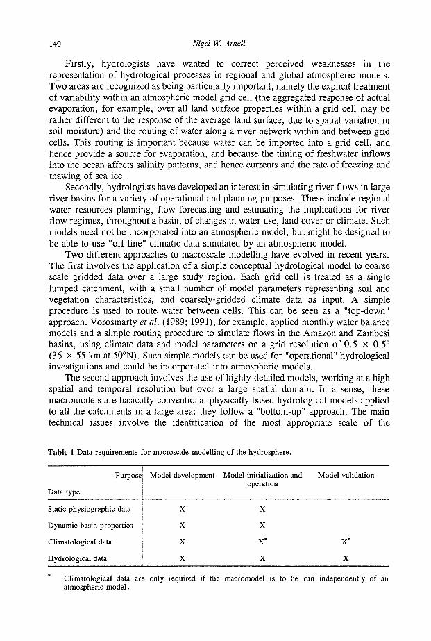
Table 1 Data requirements for macroscale modelling of the hydrosphere.
Purpose
Data type
Static physiographic data
Dynamic basin properties
Climatological data
Hydrological data
Model development
X
X
X
X
Model initialization and operation
X
X
X*
X
Model validation
X*
X
Climatological data are only required if the macromodel is to be run independently of an atmospheric model.
Data requirements for macroscale modelling of the hydrosphere 141
fundamental unit of study (of the order of 1-10 km2) and the development of procedures to generalize across a large region in order to minimize computing demands. These models will operate at a rather higher spatial resolution than will be feasible for atmospheric models in the short term at least, and it is therefore important to develop procedures for adding spatial detail to the coarse resolution rainfall and other climatic data provided by atmospheric models: this is necessary even if the models are to be run off-line from an atmospheric model.
The two approaches to macromodelling have different data requirements. Ideally neither should require data for site-specific calibration, as each uses physically-based parameters which it should be possible to derive from regional or global data sets.
DATA REQUIREMENTS
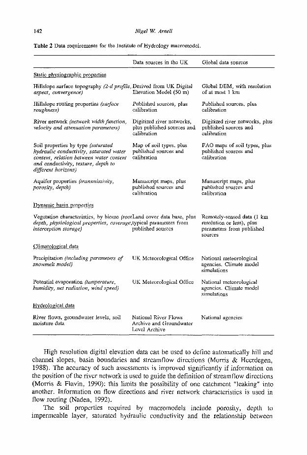
Data are required for three purposes — model development, model initialization and operation, and model validation — and there are four basic types of data — static physiographic properties, dynamic basin characteristics, climatological data and hydrological data (Table 1). It is also important to consider the spatial domain of the data required and, for dynamic data, the necessary temporal resolution; these depend on the use to which the data will be put. Table 2 reviews the requirements of the Institute of Hydrology macromodel (which follows the high-resolution, bottom-up approach), and Table 3 summarizes data availability.
Static physiographic properties
Static physiographic properties are, as their name implies, constant over time, and include topography and most soil properties. It is impossible to develop or operate a macromodel without such data.
The basic source of topographic data for a macromodel is a database of digitized elevations, known as a Digital Elevation Model (DEM). A DEM can be derived in three different ways, namely by digitizing contours from topographic maps, by analysis of stereo aerial photographs or satellite images, or by estimating altitudes directly from satellite altimetric or interferometric data. High resolution DEMs, with a grid spacing of 50 m or less, are currently available for several countries. Global digital elevation data sets based on the digitization of contours from small-scale topographic maps include the US Navy 10 arc-minute data set (12 x 18 km at 50°N), the NOAA ET0PO5 5 arc-minute data set (6 x 9 km at 50°N), and the Digital Chart of the World (Denko, 1992). The first two data sets are probably too coarse for high-resolution macromodelling purposes, but are valuable for providing baseline data for coarse-scale macromodelling. The Digital Chart of the World set is the most detailed. Unlike the first two, it consists of digitized contours, and work is currently underway to use these data a s the basis of a global 1 km gridded data set (Muller, 1992, personal communication). Higher resolution data for the entire globe can only be derived from satellite data, using Synthetic Aperture Radar (SAR) measurements. This can give a resolution down to a few metres; data from several sources should become available in the public domain in the short term, but data volumes will be huge.
142 Nigel W. Arnell
Table 2 Data requirements for the Institute of Hydrology macromodel.
Data sources in the UK Global data sources
Static physiographic properties
Hillslope surface topography (2-d profile, Derived from UK Digital aspect, convergence) Elevation Model (50 m)
Hillslope routing properties (surface roughness)
Published sources, plus calibration
Global DEM, with resolution of at most 1 km
Published sources, plus calibration
River network (network width function, Digitized river networks, Digitized river networks, plus velocity and attenuation parameters) plus published sources and published sources and
calibration calibration
Soil properties by type (saturated hydraulic conductivity, saturated water content, relation between water content and conductivity, texture, depth to different horizons)
Map of soil types, plus published sources and calibration
Manuscript maps, plus published sources and calibration
FAO maps of soil types, plus published sources and calibration
Manuscript maps, plus published sources and calibration
Vegetation characteristics, by biome (roothand cover data base, plus Remotely-sensed data (1 km depth, physiological properties, coverage,typical parameters from resolution or less), plus interception storage) published sources parameters from published
Climatological data
Precipitation (including parameters of UK Meteorological Office snowmelt model)
Potential evaporation (temperature, humidity, net radiation, wind speed)
Hydrological data
River flows, groundwater levels, soil moisture data
UK Meteorological Office
National River Flows Archive and Groundwater Level Archive
National meteorological agencies. Climate model simulations
National meteorological agencies. Climate model simulations
National agencies
High resolution digital elevation data can be used to define automatically hill and channel slopes, basin boundaries and streamflow directions (Morris & Heerdegen, 1988). The accuracy of such assessments is improved significantly if information on the position of the river network is used to guide the definition of streamflow directions (Morris & Flavin, 1990): this limits the possibility of one catchment "leaking" into another. Information on flow directions and river network characteristics is used in flow routing (Naden, 1992).
The soil properties required by macromodels include porosity, depth to impermeable layer, saturated hydraulic conductivity and the relationship between
Data requirements for macroscale modelling of the hydrosphere
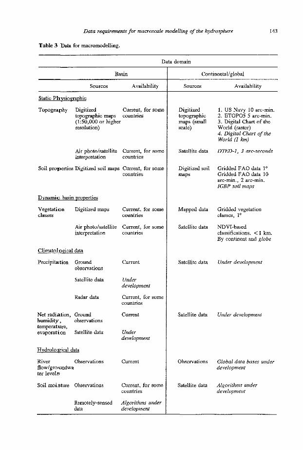
Table 3 Data for macromodelling.
143
Data domain
Basin
Sources
Static Phvsioerachic
Availability
Topography Digitized Current, for some topographic maps countries (1:50,000 or higher resolution)
Air photo/satellite interpretation
Soil properties Digitized soil maps
Dynamic basin properties
Vegetation Digitized maps classes
Air photo/satellite interpretation
Climatoloeical data
Precipitation Ground observations
Satellite data
Radar data
Net radiation, Ground humidity, observations temperature, evaporation Satellite data
Hvdroloeical data
River Observations flow/groundwa ter levels
Soil moisture Observations
Remotely-sensed data
Current, for some countries
Current, for some countries
Current, for some countries
Current, for some countries
Current
Under development
Current, for some countries
Current
Under development
Current
Current, for some countries
Algorithms under development
Continental/global
Sources
Digitized topographic maps (small scale)
Satellite data
Digitized soil maps
Mapped data
Satellite data
Satellite data
Satellite data
Observations
Satellite data
Availability
1. US Navy 10 arc-min. 2. BTOP05 5 arc-min. 3. Digital Chart of the World (raster) 4. Digital Chart of the World (1 km)
DTED-1, 3 arc-seconds
Gridded FAO data 1° Gridded FAO data 10 arc-min., 2 arc-min. IGBP soil maps
Gridded vegetation classes, 1°
NDVI-based classifications. < 1 km. By continent and globe
Under development
Under development
Global data bases under development
Algorithms under development
144 Nigel W. Arnell
conductivity and water content. Macromodels linking directly with atmospheric models also require albedo, heat capacity and thermal conductivity, in order to determine energy exchanges and hence energy available for evaporation. Some of these properties — particularly albedo — might be derived through remote sensing, but a more feasible and widely-used approach is to define typical values of each soil property for different soil types, and determine the spatial pattern of soil properties from maps of soil type. Typical values might be based on field measurements, or can be inferred by calibrating a physically-based soil moisture simulation model using high-resolution field data.
At the global scale, the FAO/UNESCO Soil Map of the World (FAO/UNESCO, 1974) shows the distributions of a number soil types, each of which can be assigned typical values for a range of soil properties (including field capacity and saturation capacity). The FAO/UNESCO Soil Map and associated soil properties have been generalized onto a 1 x 1° grid (70 x 110 km at 50°N) by both Wilson & Henderson-Sellers (1985) and Staub & Rosenzweig (1987); this scale of data is appropriate for coarse-scale macromodelling, but is not fine enough for high-resolution modelling. FAO soils data are also available from the NOAA Geophysical Data Center at a resolution of up to 2 arc-minutes (2.5 x 3.6 km at 50°N), and an IGBP project is currently deriving a new global soil data base using modelling techniques to combine existing information on soil classification with soil property relationships. Both these data bases will be more useful to high-resolution macromodels.
The final set of static physiographic properties required by macromodels concerns the characteristics of aquifers. As with soil properties, the most feasible approach is to assume typical values of properties such as transmissivity and storativity for a set of defined aquifer types. Unfortunately, "typical" values of such properties may vary over two orders of magnitude for a given rock type. Calibration will therefore be very important, which requires data on groundwater levels (as discussed below).
Dynamic basin properties
The most important dynamic basin properties are associated with basin vegetation, but some soil properties also vary with time.
Macroscale hydrological models require information on vegetation interception storage capacity - which depends on plant characteristics and spatial coverage — on rooting depths, and on aspects of plant physiology such as leaf area index, stomatal conductance, aerodynamic roughness and albedo. Most models use a limited classification of plant types or biomes, each of which has associated "typical" values, by season or month, for vegetation properties of interest (Dolman, 1992). Representative values can be determined by laboratory and field measurements, or inferred through the use of physically-based plant evaporation and energy balance models calibrated with high-resolution observational data.
The spatial distributions of biomes can be determined by digitizing or gridding published maps: examples of global data sets are the 1 x 1 ° classifications into over 50 vegetation classes prepared by both Wilson & Henderson-Sellers (1985) and Matthews (1983). These data sets are appropriate for coarse-scale macromodelling, but are not of sufficiently high resolution for detailed macromodelling.
Spatial distributions can also be derived through remote sensing, which can give very high resolution data (less than 100 m). The most commonly used indices are based
Data requirements for macroscale modelling of the hydrosphere 145
on radiance data collected in the visible and near-infrared spectral regions, and include the Normalized Difference and Simple Ratio Vegetation Indices (NDVI and SRVI respectively: Sellers et al., 1990). Both these indices are strongly related to the amount of illuminated chlorophyll in the surface vegetation cover and the amount of Absorbed Photosynthetically-Active Radiation (APAR) absorbed by the plant canopy. Additional relationships can be used to determine other plant parameters such as canopy resistance, biomass and leaf-area index. Three satellite systems currently provide NDVI data: the Advanced Very High Resolution Radiometer (AVHRR) carried on the NOAA satellites, the Multispectral Scanner and Thematic Mapper carried on LANDSAT, and the SPOT satellite (Sellers et al, 1990). Under the IGBP, weekly vegetation cover maps are currently being produced for the entire globe at a resolution of 1 km, using the AVHRR data: these data will be necessary for high-resolution macromodelling.
In the medium term, physically-based hydrological models will incorporate the dynamic simulation of vegetation growth and decline associated with changes in water and nutrient status, and macroscale hydrological models will only require data on vegetation distribution for validation purposes (vegetation data will, of course, be required for the development of phenological vegetation models).
Most soil properties are constant through time, but some, such as infiltration capacity and conductivity rates are variable due to cracking or crusting. In the short term these dynamic properties can be included as time-variable boundary conditions (the Institute of Hydrology macromodel can allow saturated hydraulic conductivity to vary through the year, for example); in the longer term, dynamic soil models should be able to simulate cracks, crusts and changes in conductivity associated with changes in soil moisture content.
Climatological data
Climatological data are the inputs that make a hydrological model run. They include precipitation (as rain or snow), temperature, net radiation, wind speed and humidity. These last parameters are used to determine potential evaporation. The key issue with respect to macromodelling is to provide the input climate data at the temporal and, more particularly, spatial scales desired. High-resolution macromodelling will require input data at a scale of 10-100 km2, whilst coarse-resolution macromodelling uses basic inputs at a scale of 1000-2000 km2 (although these data may be distributed statistically across the grid cell). It is important to distinguish between macromodels which use observed climate data as input, and macromodels which use data generated from an atmospheric model, whether on-line or off-line.
High time resolution observational data tends to be available only at a few localized points, and some means needs to be found to interpolate between measurement sites. The simplest approach interpolates just on the basis of distance between sites. More complicated procedures consider the spatial correlation structure (through the technique of kriging) or take advantages of known relationships between the characteristic to be interpolated and some controlling factor such as topography. Martinez-Cob & Cuenca (1992) provide an example of methods to interpolate potential evaporation data.
Spatial fields of input climate data can be provided by radar and by remote sensing, but these spatial fields need calibrating using ground-based data. Weather radar is being increasingly used to estimate spatial rainfall fields, and can provide data at a spatial
146 Nigel W. Arnell
resolution of as little as 2 X 2 km and at time steps of as short as 5 minutes. Rainfall fields can also be estimated, with ground calibration, from satellite-based estimates of cloud top temperatures or by passive microwave sensors. Snow-covered areas have long been mapped using satellite images, and techniques are also being developed to determine snow water equivalent using airborne gamma ray spectrometry and empirical relationships between radiance and snow water equivalents for different vegetation types (Kuittenen, 1989).
Evaporation fields can be determined through remotely-sensed energy budget data, or via empirical relationships with other remotely-sensed parameters. Choudhury (1989), for example, showed that it was possible - at a coarse space and time scale — to estimate actual evaporation using satellite-estimated brightness temperature to determine vegetation productivity and an empirical relationship between productivity and evaporation.
Spatial fields of input climate data can also be produced by combining observed and model-predicted data through a 4-dimensional data assimilation procedure. Such a procedure uses a meso-scale weather forecasting model, updated with new observational data every 6, 12 or 24 hours, to simulate atmospheric characteristics at high temporal and spatial (as fine as 10 X 10 km) scales; the continual state-updating ensures that the model does not drift too far from observed experience. In a sense, 4-dimensional data assimilation can be seen as a very sophisticated data interpolation procedure.
A different set of challenges are posed when the macroscale hydrological model is to be used with an atmospheric model, whether off-line or on-line. The atmospheric model will produce climate data at a high time resolution but, in the short and medium term at least, the spatial scale will be far too coarse for hydrological modelling. Current global models operate at a spatial resolution of the order of 105 km2, and it is unlikely that scales will be reduced to less than 104 km2 (1 x 1°) within a decade. There are two ways in which spatial detail could be added to coarse resolution atmospheric model output. The first, which is currently adopted in most atmospheric models, is to distribute the climatic variable across the grid cell according to some probability distribution. However, the greater the number of climatic variables assumed to be distributed statistically, the more complicated the joint probability distribution becomes. Also, the approach does not allow the land surface to build up a "memory": the effect of a given amount of rainfall on soil moisture status in a portion of the grid cell should depend on the preceding status, but statistical models cannot account for this. The second approach would be to try to generate realistic spatial patterns, with some form of spatial memory. This is considerably more difficult, but would make the interface with the geographically-distributed hydrological model easier. Both approaches can only be developed using high resolution spatial data sets.
Hydrological data
Hydrological data, which include river flows, groundwater levels and soil moisture contents, are used for model development, initialization and validation. They should not be required when the model is running, unless the macromodel is to be used as part of an operational flow forecasting system.
Data requirements for macroscale modelling of the hydrosphere 147
Model development and validation requires river flow data — for catchments at all scales — groundwater level data, and soil moisture data. The ability of a macromodel to simulate flows and groundwater levels at different points in a basin can be assessed using data from several flow gauges and well records, but spatial validation can also use maps of streamflow, runoff and groundwater recharge characteristics. Isoline maps of average annual runoff and monthly runoff are widely available, but have several weaknesses. Most importantly, runoff is an areal not a point phenomenon, and smoothed isoline maps - designed for point data — may be misleading. "Mosaic" maps, showing runoff in each catchment area, and grid maps showing runoff generalized onto a grid framework are more appropriate, and also provide validation data in digital form. Several methods for generalizing runoff data onto a grid have been developed, ranging from statistical interpolation between observations from small catchments, through estimates derived from gridded climate data to methods involving the superimposition of a grid onto a catchment "mosaic" map (Arnell, 1993; WMO, 1992).
Soil moisture data are less widely available. Point observational data tend to be available for only a few sites in a basin, and are difficult to interpret to provide information on the spatial distribution of soil moisture contents: the ability of a model to simulate spatial patterns in soil moisture contents should be a good guide to its skill in representing realistically runoff generation processes. Spatial soil moisture fields can in principle be determined by remote sensing but although there have been some successes which show the potential of the approach (Engman et al., 1989; Sellers et ah, 1990), there are several major problems. The method involves using a microwave radiometer to measure soil brightness temperature and calibration with observed ground truth data; calibrations depend on soil type and vegetation cover. Current procedures, however, can only estimate soil moisture contents in the top few centimetres of soil, and are affected by the presence and characteristics of vegetation. Neither global nor regional data sets of observed soil moisture data are currently available, and spatial data are only available for a small number of specific, small locations (such as the FIFE experimental area in Kansas). Indeed, soil moisture data are only very rarely collected routinely, and long time series necessary for model validation are few and far between.
Both soil moisture content and groundwater level data are also required for model initialization. The length of time that the effects of the initial soil moisture status can be seen in simulated river flows depends on soil characteristics, and in soils with a high storage capacity may be seen for several months (Wood & Calver, 1992). The more realistic the initial soil moisture characteristics, the shorter the initialization period needed to produce realistic river flows. In practice, the poor availability of spatial soil moisture data for model initialization means that initial soil moisture status has to be based on model parameters (all stores are assumed full, for example), and a long initialization period is necessary.
Groundwater characteristics change more slowly over time than soil moisture characteristics, so the influence of initial conditions lasts for much longer. It is therefore important to initialize the macromodel with a realistic set of groundwater levels, groundwater fluxes and local hydraulic gradients. In practice, groundwater level data - from which fluxes and gradients are calculated - will only be available for a very few points in a catchment, so a long wind-up period may be required in catchments with a strong groundwater component.
148 Nigel W. Arnell
CONCLUSIONS
This paper has attempted to summarize the data requirements of macroscale modelling, remembering the differing needs of different types of macromodel. It has not provided a catalogue of data sets — such catalogues are being produced through the BAHC and GCIP programmes, amongst others — but has given an indication of the sources of data.
There are two main points to make in conclusion. Firstly, macroscale model development needs observational data at a very high spatial and temporal resolution (perhaps every 15 minutes at a resolution of less than 1 km). These data, however, are only needed for a small number of case study sites. Mesoscale field experiments -such as FIFE and the HAPEX experiments — provide important sources of high resolution observational data for model development and validation. Secondly, model operation requires data on basin boundary conditions (essentially physical and vegetation characteristics) over a very large spatial domain, and ideally over the entire globe. This requirement places severe constraints on the form of macromodels, and in particular on their detailed parameterization. Modellers must reach a compromize between having enough parameters to characterize realistically all the relevant physical properties of a basin, whilst using only those parameters which can be reliably estimated from continental or global data sets. This, in fact, is the largest challenge facing the development and use of macroscale hydrological models.
Acknowledgements The review in this paper has been based on experience gained in the Macroscale Hydrological Modelling project at the Institute of Hydrology. The author acknowledges the financial support provided by the Natural Environment Research Council through its TIGER (Terrestrial Initiative in Global Environmental Research) programme, award number T91/83. Much of the information has been gleaned from unpublished sources and lists, acquired through participation in GCIP and BAHC meetings. The author thanks in particular Dr Pam Naden, Dr James Christley, Dr Jon Finch, David Morris and Eleanor Blyth, from the Institute of Hydrology, for their comments.
REFERENCES
Arnell, N. W. (1993) Developing grid-based estimates of hydrological characteristics in northern and western Europe using the FRIEND data base. In: Opportunities for Hydrological Data in Support of Climate Change Studies (in press) (Proc. NATO Advanced Research Workshop, Lahnstein, Germany, August 1991).
Choudhury, B. (1989) Relating Nimbus-7 Ghz data to land surface evaporation. In: Remote Sensing andLarge-Scale Global Processes (ai. by A. Rango) (Proc. Baltimore Symp., May 1989), 59-66. IAHS Publ. no. 186.
Denko, D. (1992) The Digital Chart of the World. GeoData. Dolman, A. J. (1992) The representation of vegetation in large-scale models of the atmosphere. In: Plant Responses
to Water Deficits: from Cell to Community (ed. by J. A. C. Griffiths & A. Smith). BIOS, Oxford. Engman,E. T., Angus, G. &Kustas, W. (1989) Relationships between the hydrologie balance of a small watershed
and remotely-sensed soil moisture. In: Remote Sensing andLarge-Scale Global Processes (ed. by A. Rango) (Proc. Baltimore Symp., May 1989), 75-84. IAHS Publ. no. 186.
FAO/UNESCO (1974) Soil Map of the World. 1:5,000,000. FAO, Paris. Kuittinen, R. (1989) Determination of snow water equivalents by using NOAA-satellite images, gamma ray
spectrometry and field measurements. In: Remote Sensing andLarge-Scale Global Processes (ed. by A. Rango) (Proc. Baltimore Symp., May 1989), 151-159. IAHS Publ. no. 186.
Data requirements for macroscale modelling of the hydrosphere 149
Martinez-Cob, A. & Cuenca, R. H. (1992) Influence of elevation on regional évapotranspiration using multivariate geostatics for various climatic regions in Oregon. J. Hydro!. 136, 353-380.
Matthews, E. (1983) Global vegetation and land use: new high-resolution data bases for climate studies. J. Clim. Appl. Meteor. 22, 474-487.
Morris, D. G. & Heerdegen, R. G. (1988) Automatically-derived catchment boundaries and channel networks, and their hydrological applications. Geomorphology 1, 131-141.
Morris, D. G. & Flavin, R. W. (1990) A digital terrain model for hydrology. In: Proceedings of the 4th International Symposium on Spatial Data Handling (Zurich). 1, 250-262.
Naden, P. S. (1992) Spatial variability in flood estimation for large catchments: the exploitation of channel network structure. Hydrol. Sci. J. 37, 53-71.
Sellers, P. L, Rasool, S. I. & Bolle, H.-J. (1990) A review of satellite data algorithms for studies of the land surface. Bull. Am. Met. Soc. 71, 1429-1447.
Staub, B . & Rosenzweig, C. (1987) Global digital data sets of soil type, soil texture, surface slope, and other properties. NASA Technical Memorandum 100685.
Vorosmarty, C. J., Moore, B., Grace, A. L., Gildea, M. P., Melillo, J. L., Peterson, B. J., Rastetter, E. B. & Steudler, P. A. (1989) Continental scale models of water balance and fluvial transport: an application to South America. Global Biogeochem. Cycles 3, 241-265.
Vorosmarty, C. J., Moore, B., Grace, A. L., Peterson, E. B. & Melillo, J. (1991) Distributed parameter models to analyse the impact of human disturbance on the surface hydrology of a large tropical drainage basin in southern Africa. In: Hydrology for the Water Management ofLarge River Basins (ed. by F. H. M. VandeVen, D. Gutknecht, D. P. Loucks&K. A. Salewicz) (Proc. ViennaSymp., August 1991), 233-244. IAHS Publ. no. 2 0 1 .
Wilson, M. F. & Henderson-Sellers, A. (1985) A global archive of land cover and soils data for use in general circulation climate models. J. Climatology 5, 119-143.
WMO (1992) Second Planning Meeting on Grid Estimation of Runoff Data. Warsaw, April 1992. WMO, Geneva. Wood, \V. L. & Calver, A. (1992) Initial conditions for hillslope hydrology modelling. / . Hydrol. 130, 379-397.