13


DAVID G. LUBAR
David Lubar is a spectrum management specialist and serves as senior project leader in The Aerospace Corporation’s Civil Systems Technology Department within the Civil Systems Group. He has more than 34 years of experience with spectrum topics, with particular focus on meteorological satellites and space systems.
DR. DAVID B. KUNKEE
Dr. David Kunkee is currently a senior project leader in The Aerospace Corporation’s Sensor Systems Subdivision within the Electronics and Sensors Division in the Engineering and Technology Group. He has provided his expertise on many microwave-based sensor payloads including the Defense Weather Satellite System, the Joint Polar Satellite System, and its predecessors. Dr. Kunkee is an officer in the IEEE Geoscience and Remote Sensing Society and has served on the National Academies’ Committee on Radio Frequencies.
LINA M. CASHIN
Lina Cashin is a senior project engineer in The Aerospace Corporation’s Defense Systems Group where she analyzes requirements for spaced-based capabilities and serves as a policy analyst for the Center for Space Policy and Strategy. She has more than 30 years of experience in national security, including 24 years in the Air Force as an expert in space operations and policy where she led a team to establish the U.S. space situational awareness data sharing program to ensure safety of spaceflight and pioneer international transparency for improved spaceflight operations.
DR. SUSAN K. AVERY
Dr. Susan Avery is an atmospheric physicist and president emerita of the Woods Hole Oceanographic Institute, and a professor emeritus at the University of Colorado in Boulder. Avery’s research interests include studies of atmospheric circulation and precipitation, climate variability and water resources, and the development of new radar techniques and instruments for remote sensing.
ABOUT THE CENTER FOR SPACE POLICY AND STRATEGY
The Center for Space Policy and Strategy is dedicated to shaping the future by providing nonpartisan research and strategic analysis to decisionmakers. The center is part of The Aerospace Corporation, a nonprofit organization that advises the government on complex space enterprise and systems engineering problems.
The views expressed in this publication are solely those of the author(s), and do not necessarily reflect those of The Aerospace Corporation, its management, or its customers.
Contact us at www.aerospace.org/policy or [email protected]

1
Summary
Fifth-generation (5G) wireless networks bring expectations of very fast, data intensive connectivity, with new capabilities that exceed today’s 4G cellular networks. These 5G systems are the future of data connectivity, providing faster download speeds and more capacity to facilitate realtime general consumer and industrial applications. Implementation of 5G wireless networks will require the use of additional swaths of the radio spectrum.a Although 5G will utilize multiple frequency bands, the United States is working to permit new communications system uses of the spectrum in millimeter wave bands above 24 gigahertz (GHz) that are adjacent to key satellite remote sensing bands, making measurements of signals in that part of the electromagnetic spectrum critical for weather forecasts difficult to detect without comprehensive regulatory protection.
Introduction Timely and accurate weather forecasts are essential for many sectors of the economy and help protect life and property. Meteorologists and hydrologists generate weather forecasts after reviewing observations and consulting outputs from numerical weather prediction (NWP) models running on supercomputers. Satellites provide over 90 percent of the input data for these NWP models.1
Weather monitoring and communication applications (i.e., measurements from weather satellites and [high band] 5G signals) are about to become neighbors in the radio spectrum. Some new 5G frequencies are adjacent to the bands where weather data for temperature, water vapor, and humidity are measured. It is important to avoid having extraneous signals generated by 5G infrastructure because these extraneous signals can
a See FCC’s FAST plan and the discussion of high-, mid-, and low-band spectrum:
https://docs.fcc.gov/public/attachments/DOC-354326A1.pdf
contaminate neighboring remote sensing bands used to detect natural emissions of the atmosphere that contribute to the computer model outputs for the forecast. The current U.S. domestic limit2 at 24 GHz of –13 dBm/MHz presents a significant potential risk as this value was designed to protect other terrestrial systems and not the sensitive measurements needed for passive sensing. This interference impact has yet to manifest as a problem because 5G infrastructure in this millimeter wave band has yet to deploy to a significant extent within the Americas to produce an upwelling component.
Regulators are not proposing to reallocate the same spectrum frequency the passive sensors use to make measurement of temperature and water vapor. Rather, the frequency being reallocated is so close that unwanted interference signals could result in

2
contamination of the weather information from the 5G signal. This 5G out-of-band signal that can result in contamination does not contribute to the transmission of information for 5G users. It is a by-product of generating the main signal that is working to allow mobile and fixed users to communicate. World experts disagree on the threshold limits for out-of-band signals beyond which measurements taken by the passive weather bands would be degraded and no longer able to serve their purpose to inform weather forecasts. Frequency regulators will include limits in their rules to constrain the level of the interference. How to arrive at the right limit is the issue in question.
To foster understanding of this complex issue, this paper describes 5G, weather passive remote sensing, and usage of adjacent electromagnetic spectrum. A companion technical paper from The Aerospace Corporation will discuss many of these topics in more depth to facilitate further understanding.
A Few Questions and Answers Are Necessary to Describe the Issue What are weather satellites measuring and why can’t they simply move elsewhere in the radio spectrum? Microwave-based measurements from instruments on orbiting weather satellites measure natural properties of Earth and the atmosphere. Instruments
may measure the amount of water vapor at different heights or may detect weak signals emitted by the atmosphere that can be used to determine the temperature or the humidity at different altitudes. The signals originate from the natural physical properties of the atmosphere and do not exist at different frequencies.
Do satellite instruments work like the receivers in our smartphones? Aren’t they performing a similar function? Actually, the type of signal being received with 5G to convey information to and from a user is quite different from the weak natural signal being detected with the weather satellite. Any detection system encounters a level of noise (primarily thermal in nature) that establishes a lower level for a receiving system. A communications signal rides above that “noise floor,” where it may be captured by a communications receiver (e.g., a smartphone or outdoor fixed receiver for 5G), which then separates and processes the voice, video, or email (information content) for the user. Any unwanted by-products from generating the communications signal, if they fall below the noise floor, are ignored by the receiver and do not impact the information transfer to a user.
A passive microwave instrument on a weather satellite is actually a radiometer, which is not a communications signal receiver. It detects weak power levels emitted from Earth or the atmosphere. These signals manifest themselves as variations of noise floor. Unwanted by-products from a 5G signal that falls within the frequency range detected by the weather satellite could raise the noise floor, masking the values of interest to the satellite or confusing the sensor. There is no current method to separate the unwanted interfering signals from the desired natural signal. The microwave sensor, which measures the total power received, would not know the data had been contaminated by the operations of the 5G communications infrastructure.
Figure 1: Natural phenomena sensed by weather satellite. (Source: American Meteorological Society, courtesy of Joshua K. Roundy.3)

3
Can’t the satellite simply filter out the undesired signal or predict what the measured value should be? The atmosphere is always changing, and the satellite sensor has no idea what specific level it may measure in any particular passive band of the spectrum at a given time. If a value is dramatically out of range, it will likely be discarded during data processing, providing a gap in the data. Otherwise, the sensor cannot determine that the measured value has been altered from the natural state by the neighboring 5G signal. Filtering out unwanted signals within the contaminated bandwidth is not feasible to the precision required by the passive sensor data applications. Unwanted signals increase the noise measured by the weather sensor.
Why would 5G transmitters cause contamination if other existing services using the radio spectrum do not? Don’t 5G towers point downward as they communicate with users? How can they impact a satellite? The proposed 5G infrastructure, which communicates data reliably and quickly for end users, will require closely spaced small cell transmitters. Since millimeter wave signals cannot directly penetrate building walls, glass, leaves, or human bodies, and the signal attenuates over a short distance on the ground, the communications equipment and transmitters are spaced closely, perhaps every 100 meters apart,b and installed to avoid blockages. 5G towers are likely to use antenna arrays with multiple beams steered electronically. Although the tower antennas are tilted below the horizon, the 5G signals will bounce off the ground,
b The uncertainty in the actual density of the 5G infrastructure, contributes to the challenges in determining the
necessary protection value for the passive bands. Significant increases in 5G tower density could increase the economic investment by the industry in order to achieve levels of service.
c ECMWF is the European Centre for Medium-Range Weather Forecasts, the home of the Integrated Forecasting System, the “so-called” Euro model cited by U.S. broadcast meteorologists. See https://www.ecmwf.int/sites/default/files/elibrary/2019/19026-radio-frequency-interference-rfi-workshop-final-report.pdf.
buildings, or terrain such that some of the energy of the unwanted out-of-band signal will move in an upward direction. An impact of the component of the 5G communications signals that propagate in an upward direction can change signals measured by the satellite instrument.
Figure 2 illustrates the upwelling effect of unwanted 5G out-of-band emissions. A hyperlink in the electronic version of this paper will play a video of this scenario.
Figure 2: Upwelling adjacent band emissions and the natural upwelling signals from Earth and the atmosphere.
What impact would interference have on the products created from the satellite data? Estimates of temperature and water vapor derived from passive microwave measurements are used in conjunction with numerical weather prediction (NWP), either as input to the models or as a quality control or data correction value. Per the European Centre for Medium-Range Weather Forecasts (ECMWF)c and the National Aeronautics and Space Administration’s (NASA’s) Global Modeling and

4
Assimilation Office (GMAO)d, the largest contributor to the reduction in forecast error is microwave-based passive remote sensing measurements from weather satellites.
Forecasters use the outputs of NWP models for situational awareness and guidance as they create nearly all meteorological or hydrological forecasts, warning, or advisory products. This includes products that warn of severe weather phenomena such as (but not limited to) hurricanes, flooding, severe thunderstorms, snow, ice, and fog. Forecast products are used by industry segments (e.g., air, land, and sea transportation; energy exploration and production; and others).
ECMWF, the organization that creates the 10-day medium range model (commonly referred to as the “Euro” model on U.S. television) said:
“The degradation in the forecasts without microwave observations means a loss of average forecast skill of around 3–6 hours for most centres, for a 72-hour (i.e. 3 day) forecast. In other words, without microwave observations, the same level of forecast guidance could only be given
d NASA’s Global Modeling and Assimilation Office (GMAO) supports NASA’s Earth Science mission and aims to
maximize the impact of satellite observations on analyses and predictions of the atmosphere, ocean, land, and cryosphere. Observation Impact Monitoring is shown at https://gmao.gsfc.nasa.gov/forecasts/systems/fp/obs_impact/
3–6 hours later than it is today. This means a significant loss of time to issue warnings, for instance, in the case of severe weather events.”4
Impacts of 5G operations from contamination of out-of-band signals into the nearby passive microwave band will not cause the total elimination of using microwave data in weather models. However, disruption of one or more microwave bands over diverse geographic areas would adversely impact the starting conditions of the NWP models. It is not practical to implement a meteorological experiment that would precisely emulate the impacts to NWP from 5G infrastructures that do not currently exist and whose properties are not well known.
Another product that could be impacted within the United States is a blended Total Precipitable Water (bTPW) operational product that provides imagery information overlaid on a global map to help forecasters analyze and forecast heavy rain and flooding and understand the transfer of moisture from ocean to land.5 This product uses both microwave-sensed and other satellite information in its creation.
Figure 3: Spectrum frequency ranges proposed for 5G and other services shown with passive spectrum (21–24 GHz) used for weather forecasting.

5
Spectrum Regulatory Considerations The Federal Communications Commission (FCC) determines what frequencies to auction for domestic 5G operations and the relevant protection values for adjacent Earth Exploration Satellite Service (EESS) passive services. The FCC may be advised by changes to the international radio regulations. The International Telecommunication Union’s (ITU’s) World Radiocommunication Conference 2019 (WRC-19)e updates the international radio regulations, which are a treaty obligation of the United States. WRC-19, which just concluded in late November 2019, considered a number of services in proximity to the passive bands used, with the 26 GHz 5G band and the adjacent passive band shown in Figure 3. Note the bands that were considered for 5G applications are denoted in ITU terminology as International Mobile Telephony-2020 (IMT-2020). Current domestic U.S. bands are shown in blue and labeled “FCC” (Federal Communications Commission).
Table 1 shows the band results from WRC-19 for 5G use internationally and the out-of-band
e WRC-19, held October 28 to November 22, 2019, in Sharm El-Sheikh, Egypt, determined revisions to the ITU
Radio Regulations. Adoption of the Radio Regulations is a treaty obligation of the United States, subject to the conditions and governing policy of the agreement.
f Those bands were associated with Agenda Item 1.13. g Some 5G bands that were not selected from the list of candidates at WRC-19 are not listed in Table 1. h The 24 GHz band base station emission level shall become –39 dBWatts/200 MHz after September 1, 2027, in the
ITU Radio Regulations i The 24 GHz band user equipment emission level shall become –35 dBWatts/200 MHz after September 1, 2027, in
the ITU Radio Regulations.
protection limits for bands where specified. The values in the yellow rows signify those bands that WRC-19 selectedf for 5G and are adjacent to passive weather bands.
Spectrum Policy Considerations, Challenges and Mitigations Considerable discussion ensued before the protection levels were selected for the 24 GHz passive band. Despite years of study and technical assessment, little is certain about the 5G equipment out-of-band signal characteristics and the number and density of such transmitters. This information is necessary for a more accurate determination of the impacts of 5G transmissions at a given protection level on measurements used by the weather community.
Subsequently, the specific impact of contamination to a given band in a geographic region and what that contamination will do to weather forecasting models is difficult to precisely quantify. It is clear that inadequate levels of protection will have a negative
Table 1: Selected 5G Band Results from ITU (Source: ITU WRC-19 Provisional Final Acts6)
5G Frequency Proposalg
Selected at WRC-19 for 5G
(Yes/No) Adjacent Passive
Weather Band
Base Station Protection Level (in 200 MHz
Bandwidth)
User Equipment Protection Level (in 200 MHz Bandwidth)
24.24–27.5 GHz Yes 23.6–24.0 GHz –33 dBWattsh -29 dBWattsi
31.3–31.8 GHz No 31.3–31.5 GHz Not selected for 5G use at this WRC
36.0–40.5 GHz Yes 37–43.5 GHz
36–37 GHz –43 dBWatts/MHz and –23 dBWatts/GHz within the 36–37 GHz band [COM4/9]7
45.5–47 GHz Yes None
47.2–48.2 GHz Yes None
50.4–52.6 GHz No 50.2–50.4 GHz Not selected for 5G use at this WRC
66–71 GHz Yes None
81–92 GHz No 86–92 GHz Not selected for 5G use at this WRC

6
impact on the use of this data. In respect to the results from WRC-19, ECMWF stated, “regarding the important 24 GHz observations is a big disappointment.”8 The WMO Secretary-General Petteri Taalas stated, “This WRC-19 decision has the potential to significantly degrade the accuracy of data collected in this frequency band which would jeopardize the operation of existing Earth observation satellite systems essential for all weather forecasting and warning activities of the national weather services.”9 More analysis is needed to determine the impact that ITU WRC-19 values of –33/–39 dBWatts for this band may have on forecasting. However, determining the correct protection value would require understanding some of the unknown issues mentioned above. More testing and transparency across the two science fields, radio communication and passive remote sensing for weather, would promote more solutions.
The ramifications of a stricter limit applied to the 5G infrastructure, could drive additional transmitter sites operating with lower power or a different beamforming scheme to install more sites, driving up 5G costs or reducing performance. The promulgation of an inadequate limit would impact the passive data sensed by weather satellites, with ramifications on how well products derived from that data provide accurate and advance guidance to forecast professionals.
Other mitigation approaches should be studied, including time sharing, where the 5G infrastructure changes frequency or switches back to 4G for a few seconds while 5G transmitters are within the footprint of orbiting passive sensing weather satellites. Carriers already have discussed sharing schemes between 5G and 4G systems.
j Emission limits for the Upper Microwave Flexible Use Service are stated in 47 CFR §30.203. k There were eleven frequency ranges evaluated internationally for 5G, and as a result the ITU announced five new
frequency ranges for 5G. Of those new bands, only two were directly adjacent to passive bands (24.25-27.5 GHz, and 37–43.5 GHz). See https://news.itu.int/wrc-19-agrees-to-identify-new-frequency-bands-for-5g/.
As another option, changes to modulation schemes or optimization of beamforming methods could also be examined to determine if that would reduce the unwanted adjacent band emissions.
Past and Future Domestic Spectrum Actions The FCC already auctioned the 24.25 to 24.45 and 24.75 to 25.25 GHz bands in May 2019. The stated emission limit for the adjacent passive band of –20 dBWatts/200 MHz was apparently identical to the existing terrestrial out-of-band limit stated in different units.j However, the terms associated with the auction indicate that the FCC can revise provisions for license holders if changed in an FCC rulemaking. This provision could be used to revise the emission limits in accordance with the new ITU Radio Regulations resulting from WRC-19.
There is nothing constraining the FCC from offering additional millimeter wave bands for use by 5G, even if those bands are not in compliance with the ITU Radio Regulations, as long as such use would not adversely impact an adjoining administration whose systems are operating in compliance with the Radio Regulations. Since this WRC did not recommend any usage change to other bands near other passive spectrums,k the FCC would not be prevented from a domestic regulatory change to add further 5G bands. Finding 5G Radio Access Nodes and handsets that would operate in different frequency bands from the remainder of the world could complicate any potential action.
One significant passive frequency range that is critical to weather forecasting is from approximately 50 GHz to 58 GHz, where atmospheric vertical
7
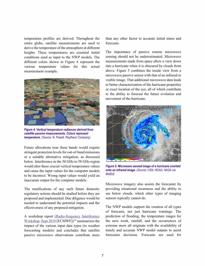
temperature profiles are derived. Throughout the entire globe, satellite measurements are used to derive the temperature of the atmosphere at different heights. These temperatures are essential initial conditions used as input to the NWP models. The different colors shown in Figure 4 represent the various temperature values for this actual measurement example.
Figure 4: Vertical temperature radiances derived from satellite passive measurements. Colors represent temperature. (Source: N. Powell, Raytheon Company)
Future allocations near these bands would require stringent protection levels for out-of-band emissions or a suitable alternative mitigation, as discussed below. Interference in the 50 GHz to 58 GHz region would alter these crucial vertical temperature values and cause the input values for the computer models to be incorrect. Wrong input values would yield an inaccurate output for the computer models.
The ramifications of any such future domestic regulatory actions should be studied before they are proposed and implemented. Due diligence would be needed to understand the potential impacts and the effectiveness of any proposed mitigation.
A workshop report (Radio-frequency Interference Workshop–Sept 2018 [ECMWF])10 summarizes the impact of the various input data types (to weather forecasting models) and concludes that satellite passive microwave observations contribute more
than any other factor to accurate initial states and forecasts.
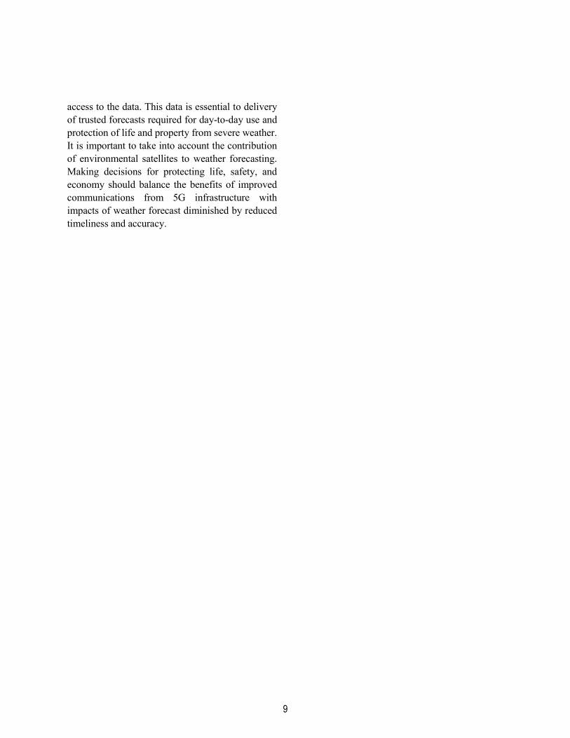
The importance of passive remote microwave sensing should not be underestimated. Microwave measurements made from space allow a view down into a hurricane when it is obscured by clouds from above. Figure 5 combines the inside view from a microwave passive sensor with that of an infrared or visible image. That additional microwave data leads to better characterization of the hurricane properties or exact location of the eye, all of which contribute to the ability to forecast the future evolution and movement of the hurricane.
Figure 5: Microwave sensed image of a hurricane overlaid onto an infrared image. (Source: USN, NOAA, NASA via MetEd)
Microwave imagery also assists the forecaster by providing situational awareness and the ability to see below clouds, which other types of imaging sensors typically cannot do.
The NWP models support the creation of all types of forecasts, not just hurricane warnings. The prediction of flooding, the temperature ranges for the next week, rainfall, and the occurrences of extreme snow all originate with the availability of timely and accurate NWP model outputs to assist forecaster decisions. Forecasts are used for

8
emergency response, industry operations, insurance valuation, city management, military operations, and by the public for decisionmaking. No area of our planet is immune from the impacts of severe weather.
Therefore, the necessary due diligence and evaluation of potential impacts to weather forecasts, from adjacent band interference caused by future 5G infrastructure should be undertaken. The risk of interference to forecast accuracy has significant consequences, both to safety of life and property and economic impact to segments of the economy.
In 2018 and as of October 2019, large-event weather-related disaster costs in the U.S. totaled $100.8 billion.l,11 These were just the events that met the National Centers for Environmental Information (NCEI) reporting criteria for Consumer Price Index (CPI)-adjusted $1 billion or greater disasters.m These numbers do not account for every severe weather event in the country. An assessment of projected economic impacts from all categories of severe weather is warranted. Subsequently, a determination of further impacts to the safety of life and property and for recovery from such events should be made if significant diminished forecast accuracy manifests from the spectrum contamination. The results from both efforts could be compared to the cost of applying mitigations to the 5G infrastructure. The focus on the economic impacts should not ignore the potential impact to safety of life.
Conclusion Implementing a 5G communications infrastructure in select millimeter wave bands (above 24 GHz) could result in significant unintended consequences for critical measurements of temperature and water
l All amounts stated are in U.S. dollars. m CPI-adjusted costs of billion-dollar events from 1980 to 2019 (to date) are $1.714 trillion as of October 8, 2019.
vapor used in weather forecasting. Prior to any spectrum allocation decision, policymakers should carefully consider the protection of incumbent use of the spectrum for passive remote sensing. Applying the existing U.S. domestic value at 24 GHz of –13 dBm/MHz presents a significant risk because this value was designed to protect other terrestrial systems and not the extremely sensitive measurements needed for passive microwave sensing of temperature and water vapor measurements. More analysis is needed to determine whether the ITU WRC-19 values of –33/–39 dBWatts (for the 24 GHz band) are adequate to protect environmental forecasting.
Selecting the appropriate threshold values for noninterference operations requires understanding of how passive microwave sensing measurements are made. The operations of satellite microwave remote sensing instruments are considerably different than communications receivers, and protections suited for one are not appropriate for both services. Moreover, consideration of alternative mitigation processes, such as time sharing, is warranted if more stringent protection criteria is not applied to the appropriate millimeter wave bands.
Other bands, such as the lower portion of the 37 GHz and the lower and mid portions of the 50 GHz band, are the source of concerns similar to the 24 GHz band. Policy decisions should also adequately protect these passive bands from unwanted interference as well.
International and domestic regulators must issue regulations that provide adequate protection between weather forecasting data frequencies and other spectrum users in order to ensure forecasters’
9
access to the data. This data is essential to delivery of trusted forecasts required for day-to-day use and protection of life and property from severe weather. It is important to take into account the contribution of environmental satellites to weather forecasting. Making decisions for protecting life, safety, and economy should balance the benefits of improved communications from 5G infrastructure with impacts of weather forecast diminished by reduced timeliness and accuracy.

1 Bormann, N., et.al., “Global observing system experiments in the ECMWF assimilation system,” Technical Memorandum 839, ECMWF January 2019, page 3.
2 47 CFR § 30.203 3 http://hydrology.faculty.ku.edu/index.html 4 Ibid, ECMWF final report cited in Footnote a. 5 https://www.star.nesdis.noaa.gov/portfolio/detail_bT
PW.php 6 https://www.itu.int/en/ITU-
R/conferences/wrc/2019/Documents/PFA-WRC19-E.pdf
7 WRC-19 Provisional Final Acts, CMR 19/2000-E, pages 394–396.
8 https://www.ecmwf.int/en/about/media-centre/news/2019/ecmwf-statement-outcomes-itu-wrc-2019-conference
9 https://public.wmo.int/en/media/news/wmo-expresses-concern-about-radio-frequency-decision
10 ECMWF Sep 2018 Newsletter. Retrieved November 2019. https://www.ecmwf.int/en/newsletter/159/news/forecast-performance-2018.
11 https://www.ncdc.noaa.gov/billions/summary-stats
References


