Drilled by: H i SCore Size: NQMaterial left in hole NX CASING- pulledCore Location: Upper Canada Site lLogged by: FR Ploeger
From To (m.) (m.)
Geology Sample No.
From To (m.) (m.)
Len (m.)
Sul AU OZ/T
AU l OZ/T
AU2ppb
SUMMARY LOG
.00 1.50 OVERBURDEN
1.50 62.00 TUFF TRACHYTE
62.00 68.64 TRACHYTE
68.64 152.00 TUFF TRACHYTE
152.00 152.63 MUDSTONE
152.63 247.82 TUFF GREYWACKE
32D04NW2043 2.26715 LEBEL 010
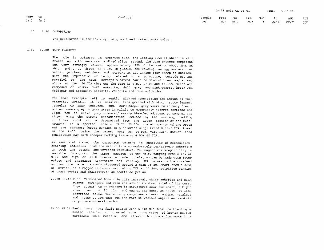
Drill Hole GL-03-01 Page: 3 of 25
From To Geology Sample From To Len Sul AU AU1 AU2 (m.) (m.) No. (m.) (m.) (m.) % OZ/T OZ/T ppb
.00 1.50 OVERBURDEN
The overburden is shallow comprising soil and broken rock/ talus.
1.50 62.00 TUFF TRACHYTE
The hole is collared in trachyte tuff, the leading 0.5m of which is well broken up with numerous oxidized slips. Beyond, the core becomes competant but very strongly veined, approximately 25% of the host to about 20m, at which point it drops to 2-3%. In places, the veining, an agglomeration of veins, patches, veinlets and streaks at all angles from steep to shallow, give the impression of being related to a structure, outside of, but parallel to, the hole, perhaps a parent fault to several branches/ strong slips at 10- 20 TGA that cut the core at 9.83, 17.00 and 18.43m. Veins are composed of white/ buff ankerite, dull grey and pink quartz, brick red feldspar and accessory sericite, chlorite and rare sulphides.
The host trachyte tuff is weakly altered considering the amount of vein material. Overall, it is massive, fine grained with minor gritty lenses, granular to ashy textured, and, dark purple grey where relatively fresh, medium mauve grey to grey green in mildly to moderately altered sections and light tan to olive grey coloured/ weakly bleached adjacent to some of the slips. With the strong contamination induced by the veining, bedding attitudes could not be determined from the upper section of the tuff, however, in a spotted lense at 19.70- 20.80m, the elongation of the spots and the contacts (upper contact on a chlorite slip) trend S 35+/-TCA. Lower in the tuff, below the veined zone at 24.90m, very faint darker lines (chloritic) may mark steeper bedding features @ SO/ 60 TGA.
As mentioned above, the carbonate veining is ankeritic in composition; staining indicates that the matrix is also moderately pervasively ankeritic in both the veined and unveined corridors. The magnetic susceptibility is variable throughout the upper section of the hole, ranging from a low of 0.17 and high of 26.0, however a crude correlation can be made with lower values and increased alteration and veining. MS values in the unveined section are more narrowly clustered around a mean of 20. Apart from a nest of pyrite in a ragged carbonate vein along TGA at 17.88m, sulphides consist of trace pyrite and chalcopyrite as scattered grains.
29.70 36.37 Tuff Carbonated Zone - In this interval, white ankerite and pink quartz stringers and veinlets amount to about S-10% of the core. They appear to be related to structures near the start, a tight shear fault 8 30 TCA, and end of the zone, at 35.00- 35.16m, described below. The veining comprises streaks, whisps, veinlets and veins to 2cm that cut the core at various angles and contain only trace mineralization.
35.00 35.16 Fault Zone - The fault starts with a 4mm mud seam, followed by ahealed cataclastic/ crushed zone consisting of broken quartzcarbonate vein material and altered host rock fragments in a
Drill Hole GL-03-01 Page: 4 of 25
From To Geology Sample From To Len Sul AU AU1 AU2 (m.) (m.) No. (m.) (m.) (m.) l OZ/T OZ/T ppb
fine to medium grained chlorite and granulated rock matrix, and end with a lcm chloritic zone. When combined, the structure could be considered a Strong Chlorite Carbonate Cataclastic Fault @ 70 TCA. MS values seem to take a dip through this interval dropping to a low of 1.07 near the start and rising back up to 18.3 close to the end.
36.37 42.15 Tuff - The fine grained, granular textured, dark brownish grey, massive tuff takes on a weakly spotted aspect through this interval. When stained with ferricyanide solution, the spots turned blue indicating an ankeritic composition; l-2% white veining is also ankeritic, however, fine pinkish coloured veins proved to be calcitic. In fact, beyond this interval, the matrix and veining become calcitic, with very minor late white ankerite veinlets .
42.15 62.00 Tuff (calcitic) - A continuation of the tuff as described above but the matrix is now pervasively calcitic; veining is a mix of calcite and ankerite. Although the tuff is massive in nature, a crude bedding angle was determined @ about 20 TCA from the contact between fine grained and gritty lenses at 49.70m. The colours of the tuff are variable, beginning with a creamy medium maroon/ brown grey and gradually changing to dark greenish grey. The granular nature is best recognized through fine pinkish coloured trachyte chips/ grains. MS values generally undulate between 7 and 32 with a spike to 41.4 at 55.0m and an estimated average of 22.
56.92 57.05 Carbonated Zone - The zone of shreddy/ elongate white ankerite forms an unmineralized Carbonate Shear Fault 8 18 TCA.
61.80 62.00 Carbonated Zone - Ending the tuff horizon is a 4cm thick creamy white to pale orange ankerite vein O 15 TCA.
62.00 68.64 TRACHYTE
With the upper contact lost in the carbonate vein, the hole enters a fine grained, massive trachyte flow. It is distinguished from the tuff by the loss of the granular texture which is replaced by a fine grained, featureless texture that coarsens slightly near the centre to reveal fine, tabular, dark green mafic laths and masses in a fine grained, grey groundmass. MS values become elevated into a higher range of 23.7 to 38.8, average about 30. The matrix is strongly calcitic as is a whispy to patchy/ streaky pink vein system that follows the core axis from 66.60 to 67.50m; other crackle/ fracture type white veinlets are ankeritic. Sulphides are trace. The trailing contact is sharp, natural, irregular 9 12 TCA; a sliver of another flow forms an arc in the side of the core further down the hole at 69m.
Drill Hole GL-03-01 Page: 5 of 25
From To Geology Sample From To Len Sul AU AU1 AU2 (m.) (m.) No. (m.) (m.) (m.) k OZ/T OZ/T ppb
68.64 152.00 TUFF TRACHYTE
There is a return to massive, fine grained trachytic tuff similar to that described above the flow. Overall, it is massive with no obvious bedding but with gradations into minor gritty sections and rare dark green clasts. At around 113.30m, a series of very faint dark trains 8 20 TGA, may highlight very weak bedding planes. Local losses of the granular texture, and irregular but sharp contacts as at 90.50/ 90.63m, may indicate nodes or tongues of flows. As with the previous tuffaceous units, there are subtle changes in colour from medium grey to green grey to brown grey, depending on the grain size, composition and alteration, veining continues to average l-2% with local concentrations to 5% over a couple of metres in places, mostly as fine pink calcite veinlets s high core angles. The matrix is strongly calcitic to 120.60m, at which point it becomes weakly ankeritic as does the veining; some pink calcite veiinlets persist to about 131m. The susceptibility continues to range between 15 and 30 to 88m and then climbs to an average of 40 to 96.50m before dropping to the lower range again.
116.60 116.93 Fault Zone - Another Strong Quartz Carbonate Mud Fault @ 40 TGA, it is characterized by 50% pink quartz and calcite veining within a section of broken core and a trailing lcm seam of mud/ gouge. The tuff is dark chocolate brown altered and moderately fractured for about 1.5m down hole. Only a few very fine specks of sulphide were observed in the FAZ or altered zone.
122.47 122.56 Quartz-Carbonate Vein Zone - Light grey alteration starts about 1.5m up hole from the vein and continues down hole for another 3m, becoming light grey brown. The vein itself is a mix of pink quartz and white ankerite with a few minor splashes of chalcopyrite. It trends @ 45 TGA.
128.00 130.20 Carbonated Zone - Veining is concentrated over the leading metre, about 15- 20% squiggly/ irregular dull white ankerite veinlets, and again at the end from 129.50- 130.20m (7510 . The former is associated with a central Carbonate Chlorite Hematite (purple) Slip ® 42 TGA and a the latter, with a Crush Sericite Oxidized Fault s 30 TCA that ends the interval. Both zones contain halos of lime green sericite around parts of the veins. There is only trace fine sulphides in the interval.
130.20 131.00 Tuff (crystal) - Although enhanced by dull white spots, often with pink rims (dolomite with calcite), that resemble crystals/ phenocrysts, the matrix also contains pale pink/ orange, pale green and waxy dark green euhedral, partly flattened crystals resembling the spots in 'spotted' trachyte flows. With an indistict, somewhat foliated gradational/ serated contact instead of a sharp contact, the unit was interpreted as a crystal tuff rather than flow. Very fine specks of pyrite occur in the rims of the white carbonateSDOtS.
Drill Hole GL-03-01 Page: 6 of 25
From (m.)
To (m.)
Geology Sample NO.
From (m.)
To (m.)
Len (m.)
Sul AU OZ/T
AU1 OZ/T
AU2 ppb
131.00 151.90 Tuff - This is a continuation of the trachyte tuff with many of the textures described above, but, there is a persistent alteration spotting, 2-4mm scale, flattened buff to buff pink coloured streaks/ spots, that are aligned along the bedding fabrics about 30+/-TCA. Bedding is also defined by very fine grained to aphanitic bands of mudstone as well as gritty lenses and elongate rip up clasts and pebbles. Many of the coarser sections contain eroded crystals from the spotted trachytes. The overall colour lightens to a medium slate grey with local brown and green washes. Alteration spots and matrix, as well as veinlets, are ankeritic, and, the susceptibility, lower, averaging approxinately 14 within a range of 8 to 27. Mineralization remains trace.
133.40 134.45 Broken Blocky Core - The section here is broken along oxidized slips that cut the core low angles, about 10-15 TGA.
144.00 147.50 Fault Zone - Not really a fault but rather a series of weak slips that meander along TGA or cut the core at low angles.
152.00 152.63 MUDSTONE
A short section of mudstone here indicates a hiatus in the deposition of tuffs and the start of normal sedimentation. The mudstone is very fine grained, medium greyish olive coloured and massive to bedded a 35/ 25 TGA. Both contacts are partly obscurred by ragged carbonate streaks/ veinlets but natural and sharp at the indicated angles. MS values drop steeply to a consistent 0.50 and the sulphide content remains trace.
152.63 247.82 TUFF GREYWACKE
There is a distinctive change here to a more sedimentary looking protolith but the lack of jasper and the higher MS values would indicate that the host is dominantly trachytic. Three major differences between the previous tuffs and the current host were noted: there is an overall colour change to medium to dark greenish grey and a total dirth of the brown, mauve or purplish shades; although spotted with light grey alteration specks, there are no primary pebbly or gritty sections, only rare scattered rip up clasts; and, the bedding attitudes shallow to the point where they follow the core axis. Apart from these features, the tuffwacke is fine grained, massive to weakly bedded with susceptibilities in the 5 to 15 range, slightly higher than greywacke and lower than most tuffs in the hole. At about 177m, there is a transition from ankerite to calcite in the matrix, beginning weak, and becoming more pervasive and stronger down hole. Veins continue to be weakly ankeritic to about 182m, from which point they are totally composed of pink calcite. In total, the calcite/ ankerite veining over the interval aggregates <0.5%. Mineralization consists of fine pinprick size sulphides amounting to trace overall.
180.25 180.29 Fault Zone - This is a Shear Carbonate Fault ® 30 TGA with no significant alteration and a thin mud seam on a central slip.
190.89 190.92 Fault Zone - Another weak structure, it comprises a carbonate slip @ 30 TGA, also with mud, and an enrichment of pink calcite stringers to about 8% over a metre up and down hole.
190.92 217.00 Tuff Greywacke - The overall features and textures remain thesame but the susceptibilities start to rise as high as 29 andthen undulate to a low of 3 by 212m, only to rise again to thehigh 20's near the end. Dips start to steepen slightly toabout 15-20 TGA.
213.00 213.01 Contact Zone (Kirkland Lake Gold) - At this point, the hole crosses the boundary from the Kirkland Lake Gold property to Queenston ground.
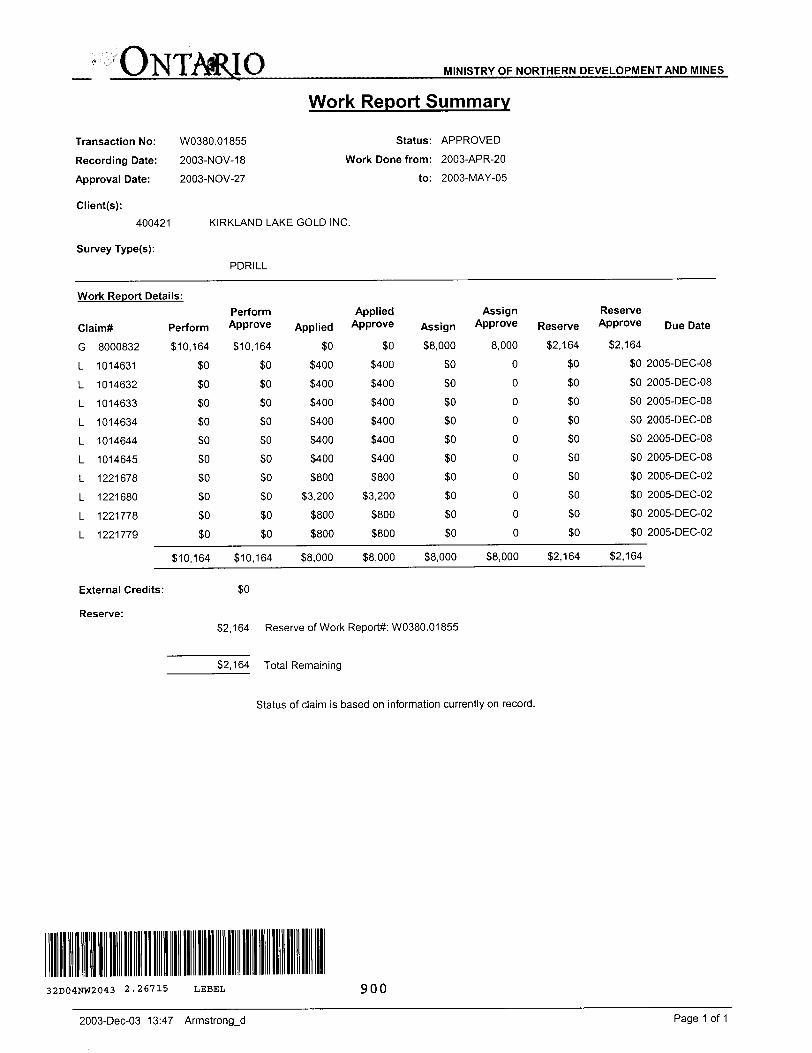
ONTARIO MINISTRY OF NORTHERN DEVELOPMENT AND MINES
Transaction No:
Recording Date:
Approval Date:
Client(s):
400421
Survey Type(s):
W0380.01855
2003-NOV-18
2003-NOV-27
Work Report Summary
Status: APPROVED
Work Done from: 2003-APR-20
to: 2003-MAY-05
KIRKLAND LAKE GOLD INC.
PDRILL
Work Report Details:
Claim*
G
L
L
L
L
L
L
L
L
L
L
8000832
1014631
1014632
1014633
1014634
1014644
1014645
1221678
1221680
1221778
1221779
Perform
510,164
50
50
50
50
SO
SO
SO
SO
SO
SO
510,164
External Credits:
Perform Approve
510,164
SO
50
SO
SO
SO
SO
SO
SO
SO
SO
510,164
50
Applied
soS400
S400
5400
S400
S400
S400
S800
S3.200
5800
5800
58,000
Applied Approve
SO
S400
5400
S400
5400
5400
S400
S800
53,200
S800
S800
S8.000
Assign
58,000
SO
SO
SO
SO
so50
50
50
SO
so
S8.000
Assign Approve
8,000
0
0
0
0
0
0
0
0
0
0
58,000
Reserve
S2.164
SO
SO
SO
SO
SO
SO
SO
SO
50
50
52,164
Reserve Approve
S2.164
SO
SO
SO
SO
SO
SO
SO
50
50
SO
S2.164
Due Date
2005-DEC-08
2005-DEC-08
2005-DEC-08
2005-DEC-08
2005-DEC-08
2005-DEC-08
2005-DEC-02
2005-DEC-02
2005-DEC-02
2005-DEC-02
Reserve:52,164 Reserve of Work Report*: W0380.01855
S2.164 Total Remaining
Status of claim is based on information currently on record.
32D04NW2043 2.26715 LEBEL 900
2003-Dec-03 13:47 Armstrong-d Page 1 of 1
Ministry ofNorthern Developmentand Mines
Date: 2003-NOV-27
Ministere du Developpement du Nord etdes Mines Ontario
We have approved your Assessment Work Submission with the above noted Transaction Number(s). The attached Work Report Summary indicates the results of the approval.
At the discretion of the Ministry, the assessment work performed on the mining lands noted in this work report may be subject to inspection and/or investigation at any time.
If you have any question regarding this correspondence, please contact STEVEN BENETEAU by email at [email protected] or by phone at (705) 670-5855.
Yours Sincerely,
/f.Ron C. Gashinski
Senior Manager, Mining Lands Section
Cc: Resident Geologist
Michael William Sutton (Agent)
Assessment File Library
Kirkland Lake Gold Inc. (Claim Holder)
Kirkland Lake Gold Inc. (Assessment Office)
Visit our website at http://www.gov.on.ca/MNDM/LANDS/mlsmnpge.htm Page: 1 Correspondence 10:18913
Thoee wishing to stake mining claims should consult with the Provincial Mining Recorders' Office of the Ministry of Northern Development and Minea for additional General Information and Limitations This map may not show unregistered land tenure and interests in
information on the status of the lands shown hereon. This map Is not Intended for navigational, survey, or land title determination purposes as the Information Contact Information: Toll Free Map Datum: NAD 83 'and including certain patents, leases, easements, right of ways,
shown on this map Is compiled from various sources. Completeness and accuracy are not guaranteed. Additional Information may also be obtained through the Provincial Mining Recorders' Office Tel: 1 (888) 415-9846 ext 57Wbjection: UTM (6 degree) flooding rights, licences, or other forms of disposition of rights and
local Land Titles or Registry Office, or the Ministry of Natural Resources, Willet Green Miller Centre 833 Ramaey Lake Road Fax: 1 (877) 670-1444 Topographic Data Source: Land Information Ontario Interest from the Crown. Also certain land tenure and land uses
Sudbury ON P3E BBS Mining Land Tenure Source: Provincial Mining Recorders' Office that restrict or prohibit free entry to stake mining claims may not be
The Information shown it derived from digital data available in the Provincial Mining Recorders' Office at the time of downloading from the Ministry of Northern Home Page: www.mndm.oov.on.ca/MNDM/MINESfl-ANDS/mlsmnpaeJitm Illustrated.
Development and Mines web site.
ONTARIOCANADA
MNMTKV OF NO*THIRN DEVELOPMENT MD MINES
PROVINCIAL MININORfcoRDtrt orrice
Mining Land Tenure Map
Date; Time of Issue: Thu Nov 27 13:80:06 EST 2003
TOWNSHIP l AREA PLAN LEBEL G-0639
ADMINISTRATIVE DISTRICTS l DIVISIONS
Mining DivisionLand Titles/Registry DivisionMinistry of Natural Resources District
Larder Lake TIMISKAMING KIRKLAND LAKE
TOPOGRAPHIC
; ' Administrative Boundaries
f """l Township
- Concession. Lot
Provincial Park
Indian Reserve
emr, Pit t pile
IS.!]m
Land Tenure
Freehold Patent
f Tl Surface And Mining Right*
j.' Surface Rlghta Only
t";,* Mining Righto Only
r\
i
Contour
MntShalte
Mira Headframe
Railway
Road
Trail
Natural OBI Pipeline
UiiliUos
Tower
F||l Surface And Mining Rights
rg l Surface Righti Only
fjn Mining Right! Only
Licence of Occupation
m Urn Not Specified
nn Surface And Mining Rigtiti
fS") Surface Rights Only
B[3 rsi
Mining Right! Only
Land Use Permit
Order in Council (Not open for staking)
Mining en
Hied Only Mining Claims 1234687
LAND TENURE WITHDRAWALS
i 1234. j Amm Withdrawn from Dtejvwltinn
Wwn Surtflcs And Mining RloWfWIMrwmWl SuHeonijMtOrf, WWrtmwWm Mining ngnkOtilyWnMrawn
Order In Council Withdrawal TypesW'snt Surface An) MnlngRighlaWltillrtwnW*s SiXaoRlgliliOnlyWIIhdnmtWm Mir*B HHK*OrilyWilMrm(ri
IMPORTANT NOTICES
UNO TENURE WITHDRAWAL DESCRIPTIONSIdentifier Type Date Description
3888 Ws Jan 1,2001 20/11/89 S.R.0.188484
W 20/79 Wsm Jan 1, 2001 SECTION 38/80 NR W 20/79 5-3-79 SR 4 MR 180705
W 20/79 Wsm Mar 5, 2001 SECTION 36/80 NR W 20/79 5-3-78 SR i MR 160705
W 56/80 Wm Jan 3. 1980 SECTION 38/80 NR W 58/80 3-1-80 M,R.O. 160705