D&R Canal Commission Application November 2013 Safety Improvements for Bull’s Island Recreation Area DELAWARE AND RARITAN CANAL COMMISSION APPLICATION for INDIVIDUAL APPROVAL and WAIVER SAFETY IMPROVEMENTS to BULL’S ISLAND RECREATION AREA Delaware & Raritan Canal State Park Delaware and Kingwood Townships, Hunterdon County New Jersey Prepared for: Delaware and Raritan Canal Commission 33 Risler Street Stockton, NJ 08559 November 2013 Prepared by: NJ DEP – Natural and Historic Resources with Civil Dynamics, Inc. P.O. Box 760 109A Route 515 Stockholm, NJ 07460‐0760
Transcript
D&R Canal Commission Application November 2013 Safety Improvements for Bull’s Island Recreation Area
DELAWARE AND RARITAN CANAL COMMISSION APPLICATION
for INDIVIDUAL APPROVAL and WAIVER
SAFETY IMPROVEMENTS
to BULL’S ISLAND RECREATION AREA Delaware & Raritan Canal State Park
Delaware and Kingwood Townships, Hunterdon County New Jersey
Prepared for: Delaware and Raritan Canal Commission
33 Risler Street Stockton, NJ 08559
November 2013
Prepared by: NJ DEP – Natural and Historic Resources
with Civil Dynamics, Inc.
P.O. Box 760 109A Route 515
Stockholm, NJ 07460‐0760
D&R Canal Commission Application November 2013 Safety Improvements for Bull’s Island Recreation Area
Table of Contents
1. APPLICATION
2. BACKGROUND
3. PROJECT DESCRIPTION & METHODOLOGY
4. MASTER PLAN OF THE DELAWARE & RARITAN STATE PARK CONFORMANCE
5. TYPES OF IMPACT a. STORMWATER RUNOFF AND WATER QUALITY IMPACT b. STREAM CORRIDOR IMPACT c. VISUAL, HISTORIC AND NATURAL QUALITY IMPACT d. TRAFFIC IMPACT
6. WAIVER OF STRICT ADHERENCE TO REVIEW STANDARDS
7. NATURAL HERITAGE DATA
8. PHOTOS
D&R Canal Commission Application November 2013 Safety Improvements for Bull’s Island Recreation Area
1. APPLICATION
D&R Canal Commission Application November 2013 Safety Improvements for Bull’s Island Recreation Area
2. BACKGROUND
Bull’s Island Recreation Area is a very popular piece of the D&R Canal State Park administered
by the New Jersey Department of Environmental Protection – Division of Parks & Forestry. It is located in Kingwood and Delaware Townships in Hunterdon County, and is bounded by the Delaware River and the Delaware and Raritan (D & R) Canal. The island marks the beginning of the feeder section of the canal which provides water into the primary canal, and is divided into northern and southern areas by a road connecting Route 29 to a pedestrian bridge that crosses the Delaware to Pennsylvania. The island is highly utilized for a wide variety of passive and active recreational activities from picnicking to boating. The southern portion of the island is a natural area with a boat launch. This project is located in the wooded northern portion of the island which has been used as a campground.
In June 2011, an American sycamore (Platanus occidentalis) tree approximately 42 inches at diameter at breast height (dbh) failed causing a human fatality. In response to this tragedy, DEP contracted with F.A. Bartlett Tree Expert Company to perform a tree risk assessment (July 2011) in the 6 acre up‐river campground area (map 1) in order to determine why a tree, which to the untrained eye appeared to be healthy, ultimately failed in the early morning of a calm, sunny day. A tree risk assessment bases its determinations not only on the condition of the tree, but the potential targets and use of the space surrounding the tree. The species composistion of this area is a mix of American sycamore, maple species (Acer spp. – silver, saccharinum; red, rubrum; boxelder, negundo), black walnut (Juglans nigra), and black locust (Robinia pseudoacacia). Evidence revealed that the root systems of the sycamore as well as the majority of the trees in the upper campground area were compromised as a result of siltation from past flooding events, structural defects and susceptibility to decay pathogens in the soil. Of the 180 trees assessed greater than 50 percent were determined to pose high to critical risk of failure.
NJ DEP determined that no matter what action would be taken, if the site was going to be open to the public an additional tree risk assessment would be required in the down river section of the campground. The evaluation (August 2012) of this 14 acre area revealed 12 different species including 28% maple (boxelder, silver, sugar, saccharum), 19% American sycamore, and 15% hackberry (Celtus occidentalis). Results of the second tree risk assessment indicated the same compromised root systems were present in the down river campsite area as the up river area. Seventy‐five percent (75%) of the sampled trees were determined to pose high to critical risk of failure. Consistent with the first tree risk assessment, roots were found to be buried under built up siltation from repeated flooding at a minimum of 6‐ 18 inches and up to 2 feet or more (picture 1). Buttress roots, the structural support for a tree were rarely detectable and adventitious roots which serve to feed and not stabilize the trees had appeared (Picture 2). Nine of the twenty six highest flooding events have occurred in the last ten years and four of those events occurred in 2011. Three years of consecutive flooding occurred in 2004, 2005, and 2006. Root system health and integrity is a primary concern.
It should be noted that in the period between their first tree risk assessment in July 2011 and the third tree risk assessment in November 2012, at least 30 trees failed or had significant failures throughout the entire former campground area
NJ DEP developed two alternatives as a result of the second tree risk assessment:
D&R Canal Commission Application November 2013 Safety Improvements for Bull’s Island Recreation Area
1) Completely close the campground area to all public access precluding access to and from the Delaware River and wing dam (weir), or 2) Establish a safe corridor for limited public access to and from the Delaware River and wing dam that would allow most of the existing trees to remain while simultaneously addressing public safety and access concerns.
In order to continue the recreational use of the northern portion of the island, the decision was made to move forward with the establishment of a safe, passive recreation corridor along the southern end of this area extending west to the Delaware River. This application is for the execution of that project.
D&R Canal Commission Application November 2013 Safety Improvements for Bull’s Island Recreation Area
Map 1 . Up river campground and down river campground tree risk assessment areas. Park officePedestrian Bridge
Park office
Pedestrian Bridge
D&R Canal Commission Application November 2013 Safety Improvements for Bull’s Island Recreation Area
Picture 1. Soil removed 24 inches down a tree stem and no buttress roots were found.
Picture 2. Adventitious roots present at the soil surface.
D&R Canal Commission Application November 2013 Safety Improvements for Bull’s Island Recreation Area
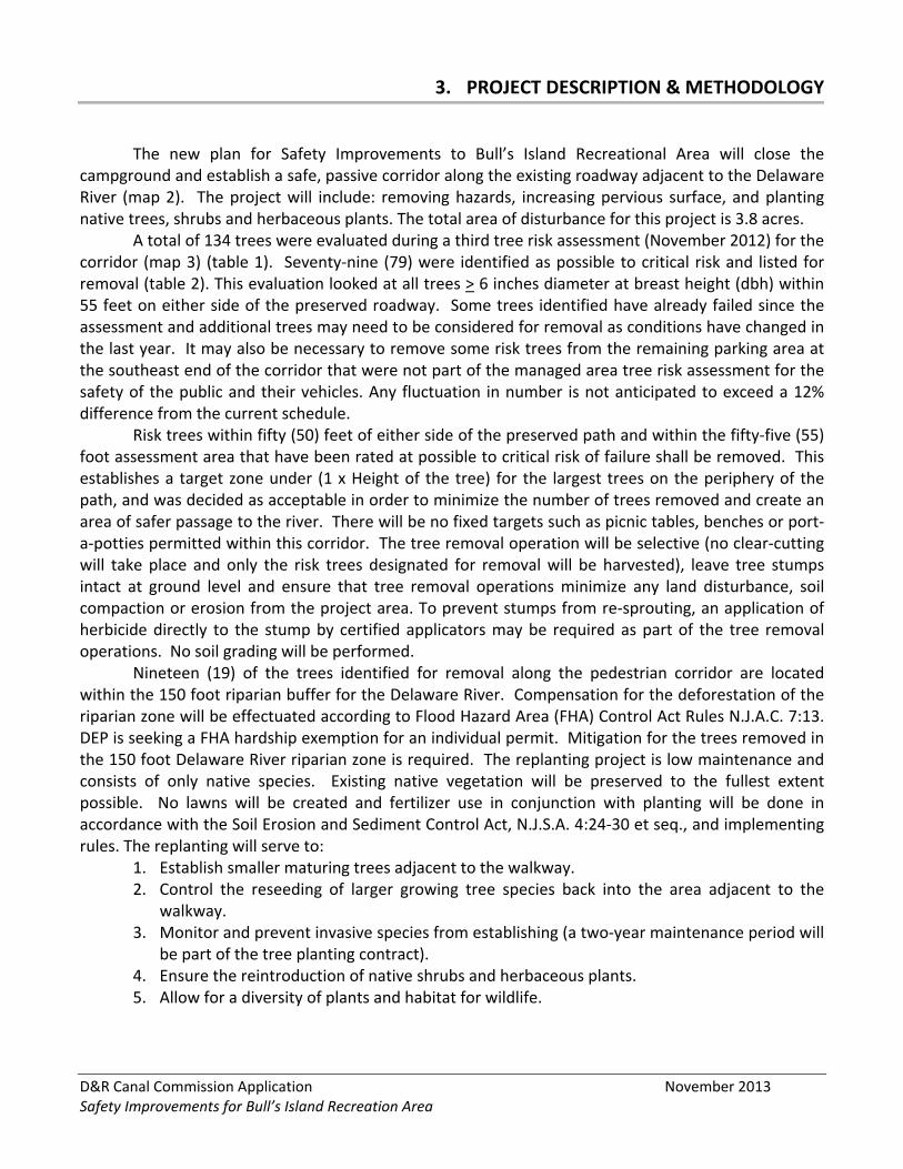
3. PROJECT DESCRIPTION & METHODOLOGY
The new plan for Safety Improvements to Bull’s Island Recreational Area will close the
campground and establish a safe, passive corridor along the existing roadway adjacent to the Delaware River (map 2). The project will include: removing hazards, increasing pervious surface, and planting native trees, shrubs and herbaceous plants. The total area of disturbance for this project is 3.8 acres.
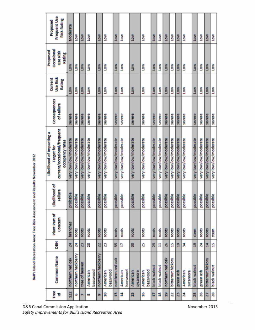
A total of 134 trees were evaluated during a third tree risk assessment (November 2012) for the corridor (map 3) (table 1). Seventy‐nine (79) were identified as possible to critical risk and listed for removal (table 2). This evaluation looked at all trees > 6 inches diameter at breast height (dbh) within 55 feet on either side of the preserved roadway. Some trees identified have already failed since the assessment and additional trees may need to be considered for removal as conditions have changed in the last year. It may also be necessary to remove some risk trees from the remaining parking area at the southeast end of the corridor that were not part of the managed area tree risk assessment for the safety of the public and their vehicles. Any fluctuation in number is not anticipated to exceed a 12% difference from the current schedule.
Risk trees within fifty (50) feet of either side of the preserved path and within the fifty‐five (55) foot assessment area that have been rated at possible to critical risk of failure shall be removed. This establishes a target zone under (1 x Height of the tree) for the largest trees on the periphery of the path, and was decided as acceptable in order to minimize the number of trees removed and create an area of safer passage to the river. There will be no fixed targets such as picnic tables, benches or port‐a‐potties permitted within this corridor. The tree removal operation will be selective (no clear‐cutting will take place and only the risk trees designated for removal will be harvested), leave tree stumps intact at ground level and ensure that tree removal operations minimize any land disturbance, soil compaction or erosion from the project area. To prevent stumps from re‐sprouting, an application of herbicide directly to the stump by certified applicators may be required as part of the tree removal operations. No soil grading will be performed.
Nineteen (19) of the trees identified for removal along the pedestrian corridor are located within the 150 foot riparian buffer for the Delaware River. Compensation for the deforestation of the riparian zone will be effectuated according to Flood Hazard Area (FHA) Control Act Rules N.J.A.C. 7:13. DEP is seeking a FHA hardship exemption for an individual permit. Mitigation for the trees removed in the 150 foot Delaware River riparian zone is required. The replanting project is low maintenance and consists of only native species. Existing native vegetation will be preserved to the fullest extent possible. No lawns will be created and fertilizer use in conjunction with planting will be done in accordance with the Soil Erosion and Sediment Control Act, N.J.S.A. 4:24‐30 et seq., and implementing rules. The replanting will serve to:
1. Establish smaller maturing trees adjacent to the walkway. 2. Control the reseeding of larger growing tree species back into the area adjacent to the
walkway. 3. Monitor and prevent invasive species from establishing (a two‐year maintenance period will
be part of the tree planting contract). 4. Ensure the reintroduction of native shrubs and herbaceous plants. 5. Allow for a diversity of plants and habitat for wildlife.
D&R Canal Commission Application November 2013 Safety Improvements for Bull’s Island Recreation Area
The majority of the existing structures including bathhouses, a playground and paved roadways will be removed totaling 0.9 acres of impervious surface. The roadway for the new corridor as well as the path for NJ Water Supply Authority access will remain. “No Public Access” signs will be posted along the area of concern, and a gate will be installed at the entrance to the NJ Water Supply Authority access road. Existing structures and roadway pavement will be removed with no additional disturbance. The limit of disturbance for the demolition will be consistent with the footprint of the impervious structures and pavement. All grading will remain consistent with existing conditions.
D&R Canal Commission Application November 2013 Safety Improvements for Bull’s Island Recreation Area
Map 2. . Proposed Site Plan for Safety Improvements.
Paved driveway to remain
D&R Canal Commission Application November 2013 Safety Improvements for Bull’s Island Recreation Area
Map 3. Location of trees in the proposed pedestrian corridor.
D&R Canal Commission Application November 2013 Safety Improvements for Bull’s Island Recreation Area
Table 1. Inventory and analysis of 134 trees evaluated in the proposed managed corridor.
D&R Canal Commission Application November 2013 Safety Improvements for Bull’s Island Recreation Area
D&R Canal Commission Application November 2013 Safety Improvements for Bull’s Island Recreation Area
D&R Canal Commission Application November 2013 Safety Improvements for Bull’s Island Recreation Area
D&R Canal Commission Application November 2013 Safety Improvements for Bull’s Island Recreation Area
D&R Canal Commission Application November 2013 Safety Improvements for Bull’s Island Recreation Area
D&R Canal Commission Application November 2013 Safety Improvements for Bull’s Island Recreation Area
D&R Canal Commission Application November 2013 Safety Improvements for Bull’s Island Recreation Area
Table 2. Bull's Island safe corridor tree removal summary.
Tree ID Tag # Tree Species (common name) Diameter at Breast Height (DBH)
1 Juglans nigra (black walnut) 18”
2 Acer saccharinum (silver maple) 48”
7 Ailanthus altissima (tree of heaven) 23”
10 Tilia americana (American basswood) 23”
13 Quercus rubra (northern red oak) 35”
14 Tilia americana (American basswood) 17”
15 Platanus occidentalis (American sycamore) 30”
20 Quercus velutina (black oak) 39”
21 Platanus occidentalis (American sycamore) 24”
23 Fraxinus pennsylvanica (green ash) 19”
24 Platanus occidentalis (American sycamore) 24”
25 Juglans nigra (black walnut) 19”
29 Platanus occidentalis (American sycamore) 22”
30 Quercus rubra (northern red oak) 19”
31 Quercus rubra (northern red oak) 24”
32 Fraxinus pennsylvanica (green ash) 21”
33 Juglans nigra (black walnut) 14”
34 Juglans nigra (black walnut) 13”
37 Juglans nigra (black walnut) 12”
38 Juglans nigra (black walnut) 14”
39 Tilia americana (American basswood) 20”
41 Juglans nigra (black walnut) 13”
42 Juglans nigra (black walnut) 25”
44 Juglans nigra (black walnut) 24”
45 Juglans nigra (black walnut) 24’
46 Platanus occidentalis (American sycamore) 25”
47 Juglans nigra (black walnut) 20”
49 Fraxinus pennsylvanica (green ash) 29”
50 Platanus occidentalis (American sycamore) 24”
51 Platanus occidentalis (American sycamore) 30”
53 Platanus occidentalis (American sycamore) 29”
54 Juglans nigra (black walnut) 27”
55 Acer negundo (boxelder maple) 24”
56 Juglans nigra (black walnut) 28”
57 Juglans nigra (black walnut) 29”
58 Quercus rubra (northern red oak) 39”
59 Juglans nigra (black walnut) 22”
60 Platanus occidentalis (American sycamore) 13”
61 Platanus occidentalis (American sycamore) 39”
D&R Canal Commission Application November 2013 Safety Improvements for Bull’s Island Recreation Area
Tree ID Tag # Tree Species (common name) Diameter at Breast Height (DBH)
62 Platanus occidentalis (American sycamore) 26”
63 Platanus occidentalis (American sycamore) 22”
64 Platanus occidentalis (American sycamore) 28”
65 Platanus occidentalis (American sycamore) 25”
66 Platanus occidentalis (American sycamore) 23”
67 Fraxinus pennsylvanica (green ash) 31”
68 Juglans nigra (black walnut) 29”
75 Platanus occidentalis (American sycamore 34”
76 Acer saccharinum (silver maple) 48”
77 Platanus occidentalis (American sycamore) 41”
78 Platanus occidentalis (American sycamore) 35”
91 Platanus occidentalis (American sycamore) 30”
92 Platanus occidentalis (American sycamore) 32”
93 Acer negundo (boxelder maple) 19”
94 Acer negundo (boxelder maple) 18”
95 Acer saccharum (sugar maple) 26”
98 Acer saccharum (sugar maple) 19”
99 Juglans nigra (black walnut) 21”
100 Juglans nigra (black walnut) 23”
101 Carya cordiformis (bitternut hickory) 26”
103 Juglans nigra (black walnut) 23”
104 Juglans nigra (black walnut) 24”
106 Juglans nigra (black walnut) 23”
109 Platanus occidentalis (American sycamore) 28”
110 Juglans nigra (black walnut) 27”
111 Gleditsia triacanthos (honey locust) 23”
112 Juglans nigra (black walnut) 12”
114 Fraxinus pennsylvanica (green ash) 16”
115 Juglans nigra (black walnut) 16”
117 Juglans nigra (black walnut) 17”
121 Juglans nigra (black walnut) 14”
122 Quercus rubra (northern red oak) 24”
127 Fraxinus pennsylvanica (green ash) 19”
130 Tilia americana (American basswood) 20”
131 Acer negundo (boxelder maple) 24”
132 Acer negundo (boxelder maple) 19”
133 Acer negundo (boxelder maple) 21”
134 Acer saccharinum (silver maple) 33”
3 Platanus occidentalis (American sycamore) 44”
35 Fraxinus Americana (green ash) 21”
D&R Canal Commission Application November 2013 Safety Improvements for Bull’s Island Recreation Area
Four‐hundred twenty‐five (425) trees will be planted. Native tree species that do not exceed 40 feet in height have been selected to avoid creation of a future risk situation. The planting list was developed in cooperation among the NJDEP’s Office of Natural Lands Management, naturalists from the State Park Service, biologists from the endangered and non‐game species program, and foresters from the State Forestry Service. Planting will be done according to the Cluster Planting Layout (figure 1) to give the planting a random, naturalized appearance. The replanting has been prioritized in the following way (map 4):
1. Riparian Corridor – reforestation in the area along the east site of the existing path within
the 150’ riparian zone where harvesting will occur. 2. Woodland Corridor – reforestation in the area along the path outside the 150’ riparian
buffer where harvesting will occur. 3. Riparian Woodland – enrichment planting in the area within the 150’ riparian buffer where
no harvesting will occur, but where an impervious roadway will be removed. 4. Campground Enrichment – enrichment planting in the area outside the 150’ riparian buffer
where no harvesting will occur, but where existing structures and impervious roadways will be removed.
The planting will primarily consist of 2 – 2.5 inch balled and burlap (B&B) material. Two native
species pussy willow (Salix discolor) and smooth alder (Alnus serrulata) are not available in caliper inch sizes and will be procured in containers. These two species represent 45 of the 425 trees that will be planted and will be planted where existing roadways are being removed. In addition to the trees, 540 native shrubs and 900 herbaceous perennials will be planted (table 3).
D&R Canal Commission Application November 2013 Safety Improvements for Bull’s Island Recreation Area
below
Figure 1. Cluster Layout Planting Method diagram and planting community description.
D&R Canal Commission Application November 2013 Safety Improvements for Bull’s Island Recreation Area
Table 3. Bull’s Island replanting list species, quantities and sizes.
D&R Canal Commission Application November 2013 Safety Improvements for Bull’s Island Recreation Area
Map 3. Replanting communities and priority areas.
D&R Canal Commission Application November 2013 Safety Improvements for Bull’s Island Recreation Area
4. MASTER PLAN OF THE DELAWARE & RARITAN CANAL STATE PARK COMPLIANCE
This project strives to conform as nearly as possible to the Master Plan of the Delaware & Raritan Canal State Park adopted by the Commission in that the development plan for Bull’s Island, “calls for maintaining and upgrading the present facilities, with clearer distinctions made among areas directed toward river uses, camping and picnicking, and the natural area.” This project is consistent with the Master Plan objectives as follows:
1. The Delaware and Raritan Canal is a water supply system. This project does not take place directly on or along the canal itself. The removal of impervious surfaces and structures will actually provide a net benefit to water quality by reducing overall peak flow for the 2, 10, and 100‐year events by 13%, 8%, and 5% respectively. There will also be an overall decrease in the runoff volume for the 2, 10, and 100‐year events by 8%, 5%, and 3% respectively.
2. The Park is a site for recreational activities.
The primary goal of this project is to ensure that the northern portion of Bull’s Island is safe and open for recreational activity that is compatible with the flood plain environment and provides for the enjoyment of the Delaware River and wing dam. This project directly seeks to ensure that access is “allocated to all parts of the park in order to avoid concentrating use at a few locations” by keeping the northern portion of the island open to the public to access the Delaware River and wing dam and to enjoy the wooded space.
3. The Park is a historic resource.
The NJ State Historic Preservation Office (SHPO) has state that, “the project does not have the potential to affect the historic character of the Canal.” Please refer to the letter included with this submission.
4. The Park is an area that should be maintained in its natural state.
The decision to pursue the establishment of a corridor to the Delaware River and wing dam was done with consideration of preserving the wildlife habitat and natural vegetative communities to the maximum extent possible while facilitating safe public access to the site. This course of action minimizes the amount of disturbance to the existing landscape, and seeks to mitigate and enrich the site through the planting and maintenance of 1,865 native trees, shrubs and herbaceous plants. All plants have been identified and vetted as appropriate for the floodplain. The island will continue to serve as a migratory route for plants and animals.
D&R Canal Commission Application November 2013 Safety Improvements for Bull’s Island Recreation Area
This project will not adversely impact any rare, threatened or endangered species. Included with this application are the natural heritage data for the site as well as a letter from the NJDEP Division of Fish and Wildlife. NJ State Threatened and Endangered Plants: Broad‐leaf Waterleaf (Hydrophyllum canadense) – One sub‐population is located on the island and it is not in the area of the proposed work. Missouri Gooseberry (Ribes missouriense) – Two sub‐populations have been identified on the island. Neither one is in the area of the proposed work. NJ State Threatened and Endangered Wildlife: Wood Turtle (Glyptemys insculpta) – There is no record of nesting turtles on the island. There will be no adverse impact on turtles as long as there is still forest cover. Bald Eagle (Haliaeetus leucocephalus) – There are no significant impacts for the species as sufficient perch trees for resting or hunting will remain. Tree removal and all other identifies timing restricted activities will take place outside of wildlife breeding and roosting seasons. Swift replanting will ensure habitat is reestablished quickly. Restoration will maintain native plant communities to provide habitat.
5. The park is a means of enhancing urban areas. Bull’s Island has been identified as a rural environmental type based upon the character of this section of the Park and its adjoining corridor and is defined as such in the Park’s Master Plan.
D&R Canal Commission Application November 2013 Safety Improvements for Bull’s Island Recreation Area
5. TYPES OF IMPACT
As a major project (a disturbance of 1 acre or more of land) in Zone A this project is subject to impact reviews for stormwater runoff and water quality, stream corridor impact, traffic impact, and visual, historic and natural impact.
A. Stormwater Runoff and Water Quality Impact
The removal of impervious surfaces and structures will actually provide a net benefit to water quality by reducing overall peak flow for the 2, 10, and 100‐year events by 13%, 8%, and 5% respectively. There will also be an overall decrease in the runoff volume for the 2, 10, and 100‐year events by 8%, 5%, and 3% respectively. Refer to enclosed signed and sealed Stormwater Management Report for Safety Improvements to Bull’s Island Recreation Area prepared by Civil Dynamics, Inc. and the checklist enclosed.
D&R Canal Commission Application November 2013 Safety Improvements for Bull’s Island Recreation Area
B. Stream Corridor Impact
Historically, stream corridor impact has not been attributed as applicable to the Bull’s Island
area of the park by the Delaware and Raritan Canal State Park Commission.
D&R Canal Commission Application November 2013 Safety Improvements for Bull’s Island Recreation Area
C. Visual, Historic and Natural Quality Impact
Map 3 of this application shows the location of the existing trees in the project area. Table 1 details the all the species inventoried in the project area at > 6 inches diameter at breast height. Fifty‐five of those trees will remain and seventy‐nine probable to critical risk trees are to be removed and are detailed in Table 2. Although visual impact is inherent in the removal of any tree, this project has planned for extensive compensatory planting with 1,865 native trees, shrubs and herbaceous plants. The natural quality of the area will be enhanced with the removal of existing structures (photo 3) and impervious surfaces (photo 2). The natural terrain, soil, stones, and vegetation will be preserved wherever possible. The project has been assessed to have no impact on any historic resource by the State Historic Preservation Office (letter enclosed).
D&R Canal Commission Application November 2013 Safety Improvements for Bull’s Island Recreation Area
D. Traffic Impact This project will not generate any additional traffic and will serve to reduce traffic in the park
through the elimination of the campground sites and the access roads to them.
D&R Canal Commission Application November 2013 Safety Improvements for Bull’s Island Recreation Area
6. WAIVER OF STRICT ADHERENCE TO REVIEW STANDARDS
A waiver of review standards is being sought due to compelling public need. The impetus for this project was the fatality of a camper due to the failure of an otherwise seemingly healthy tree in the early morning of a clear, still and sunny day. It was determined that the cause of the lethal failure was compromised root health and integrity caused by repeated siltation upon the root system from flood events. Nine of the twenty‐six highest flooding events have occurred in the last ten years and four of those events occurred in 2011. Three years of consecutive flooding occurred in 2004, 2005, and 2006. After three tree risk assessments by an independent tree expert company this condition was revealed to be affecting the majority of the trees in the campground area. In the tree risk assessment for the up‐river campground where the fatality occurred, greater than 50% of the 180 trees analyzed were stated to pose high to critical risk of failure at the roots. In the tree risk assessment for the down‐river portion of the campground, 75% of the trees in the sample plots were stated to pose high to critical risk of failure at the roots. With this knowledge and given that in the period from July 2011 to November 2012 at least 30 trees failed or had significant failures throughout the entire former campground area the NJDEP was left with two choices: 1) completely close the northern area of Bull’s Island Recreation Area to the public, or 2) develop an alternative that would meet the safety needs of the public while continuing to satisfy the objectives of the Park’s Master Plan by providing for passive recreational activities, and ensuring the natural condition of the rural environment type. The project detailed in this application to close the campground and establish a 100’ wide safe pedestrian corridor through the removal of risk trees along an existing driveway providing access to and from the Delaware River and wing dam is a comprehensive solution to serve an essential public safety need while providing public access. A waiver from the visual impact standard is also sought. It is understood that visual impact is inherent in the removal of any tree. The site currently has a rather open view both under the existing overstory of the proposed corridor and once the Delaware River is reached. There will be no change in land use, and this project has planned for extensive compensatory planting with 1,865 native trees, shrubs and herbaceous plants (figure 1, table 3, map 4). The visual aesthetic will be altered due to a reduction in the number of overstory trees; however, a forested view will still remain composed of a distribution of diverse understory trees.
D&R Canal Commission Application November 2013 Safety Improvements for Bull’s Island Recreation Area
7. NATURAL HERITAGE DATA
D&R Canal Commission Application November 2013 Safety Improvements for Bull’s Island Recreation Area
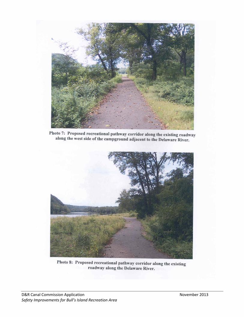
8. PHOTOS Provided by Jess Bergman, Civil Dynamics, Inc.
D&R Canal Commission Application November 2013 Safety Improvements for Bull’s Island Recreation Area
D&R Canal Commission Application November 2013 Safety Improvements for Bull’s Island Recreation Area
D&R Canal Commission Application November 2013 Safety Improvements for Bull’s Island Recreation Area
D&R Canal Commission Application November 2013 Safety Improvements for Bull’s Island Recreation Area
D&R Canal Commission Application November 2013 Safety Improvements for Bull’s Island Recreation Area