52
DELTA BREEZE DELTA BREEZE …MAKES ME FEEL FINE…
| Date post: | 17-Dec-2015 |
| Category: |
Documents |
| Upload: | david-lawson |
| View: | 215 times |
| Download: | 1 times |
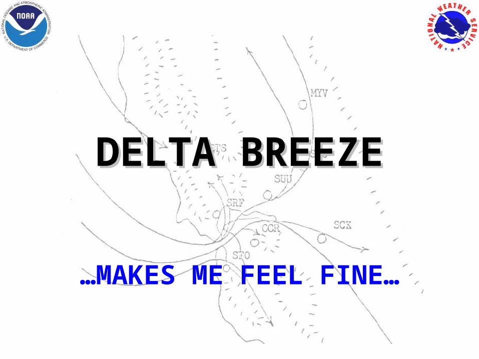
DELTA BREEZEDELTA BREEZE
…MAKES ME FEEL FINE…

“Between the two poles of simplicity and diversity, the
searching mind of man remains caught…No matter what he does
or what he invents, there is always nature to teach him a
lesson in ............
~ H. Riehl
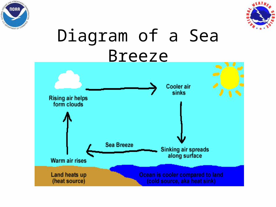
Diagram of a Sea Breeze
Wallington’s (1961) factors for inland penetration of the sea breeze
• Strength of solar radiation• Direction/Strength of
general wind flow• Depth of marine layer• Sea temperature

As land-sea temp gradients press gradients Schmidt (1947)…
•Sea breeze…accelerates as long as a land-sea temp gradient exists.• Max sea breeze occurs well after the max temp difference between land-sea….EXCEPT… the effects of Friction…………..
The “Self-Regulating” Sea Breeze
•The stronger the breeze…more marine air is advected inland•This reduces the difference in temp/density between land/sea•This contrast reduces the pressure gradient….and weakens the sea breeze
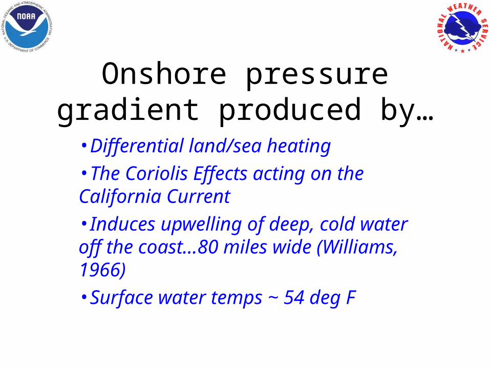
Onshore pressure gradient produced by…
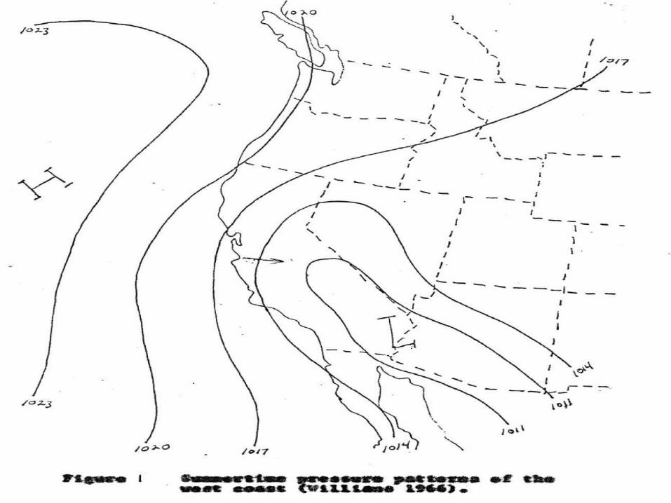
•Differential land/sea heating•The Coriolis Effects acting on the California Current•Induces upwelling of deep, cold water off the coast…80 miles wide (Williams, 1966)•Surface water temps ~ 54 deg F
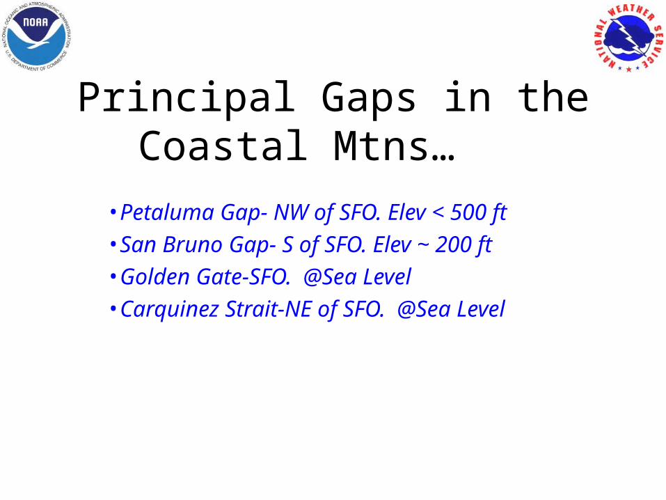
Principal Gaps in the Coastal Mtns…
•Petaluma Gap- NW of SFO. Elev < 500 ft•San Bruno Gap- S of SFO. Elev ~ 200 ft•Golden Gate-SFO. @Sea Level•Carquinez Strait-NE of SFO. @Sea Level
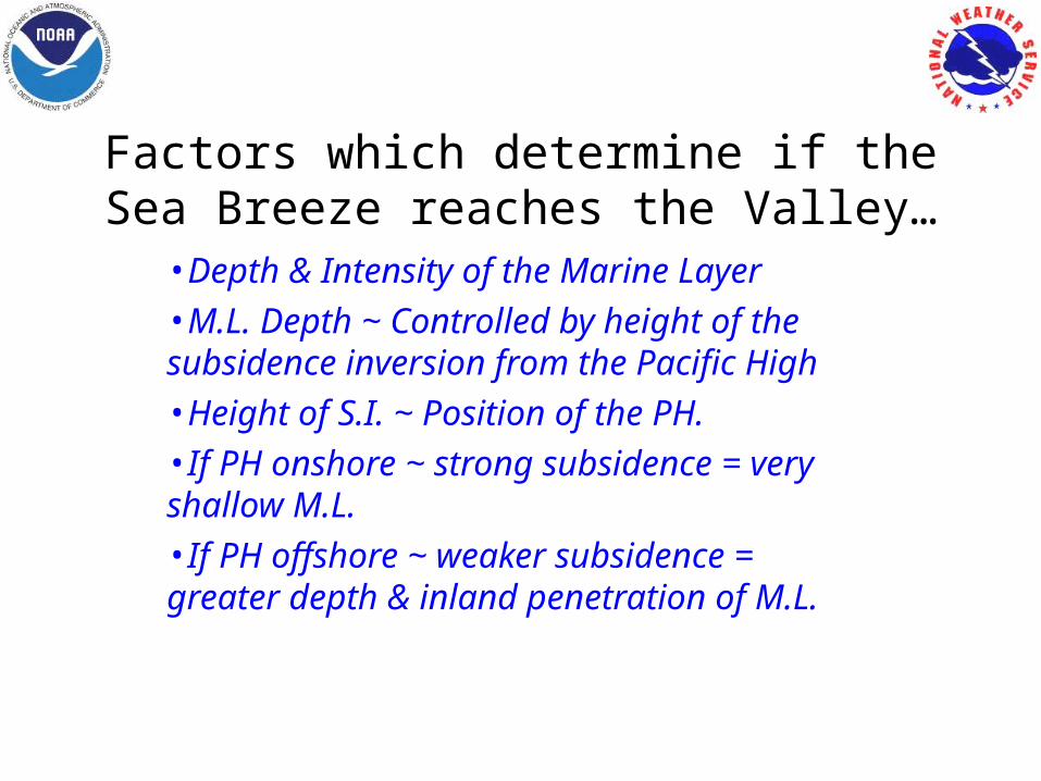
Factors which determine if the Sea Breeze reaches the Valley…
•Depth & Intensity of the Marine Layer•M.L. Depth ~ Controlled by height of the subsidence inversion from the Pacific High•Height of S.I. ~ Position of the PH. •If PH onshore ~ strong subsidence = very shallow M.L.•If PH offshore ~ weaker subsidence = greater depth & inland penetration of M.L.
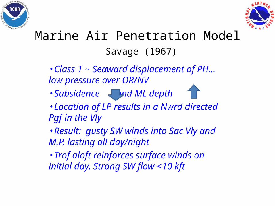
Marine Air Penetration Model Savage (1967)
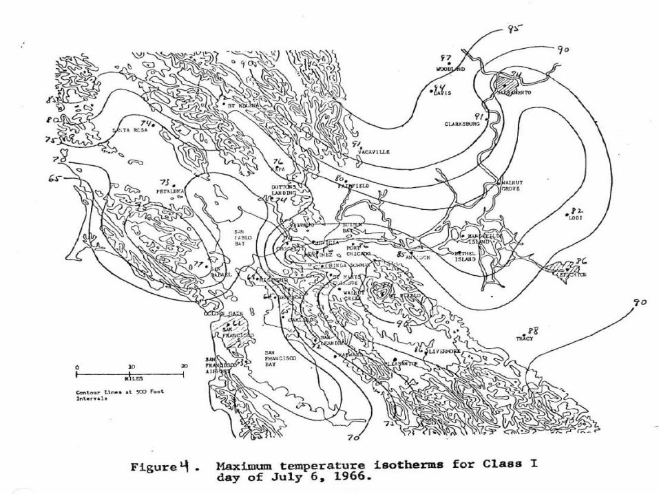
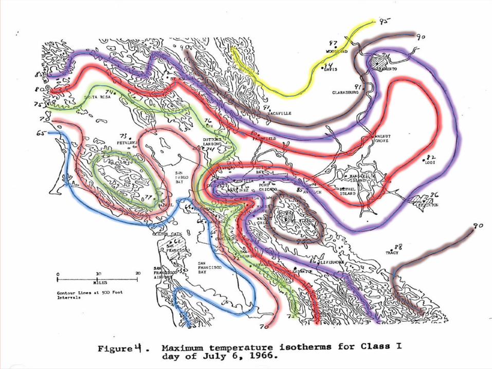
•Class 1 ~ Seaward displacement of PH…low pressure over OR/NV•Subsidence and ML depth •Location of LP results in a Nwrd directed Pgf in the Vly•Result: gusty SW winds into Sac Vly and M.P. lasting all day/night•Trof aloft reinforces surface winds on initial day. Strong SW flow <10 kft

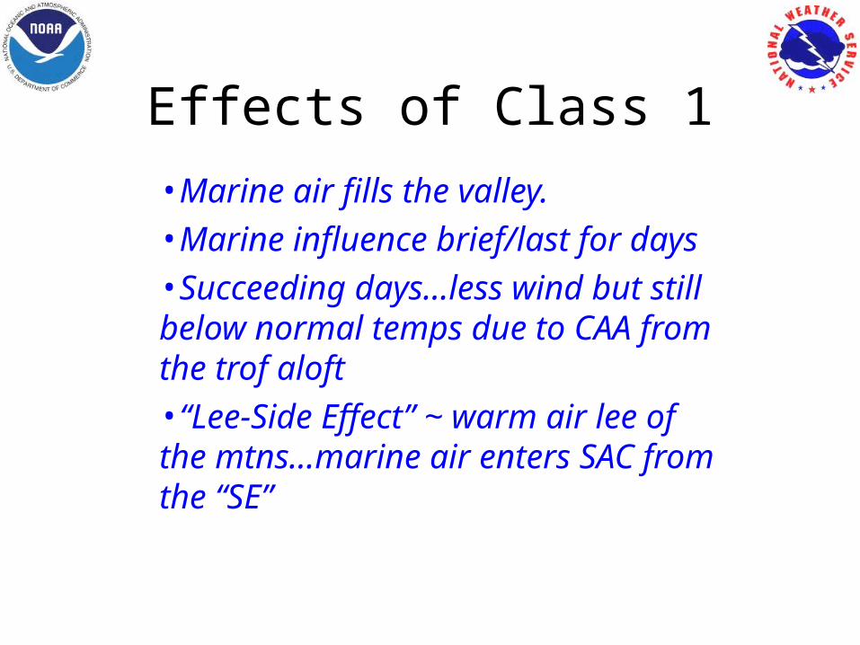
Effects of Class 1•Marine air fills the valley. •Marine influence brief/last for days •Succeeding days…less wind but still below normal temps due to CAA from the trof aloft •“Lee-Side Effect” ~ warm air lee of the mtns…marine air enters SAC from the “SE”
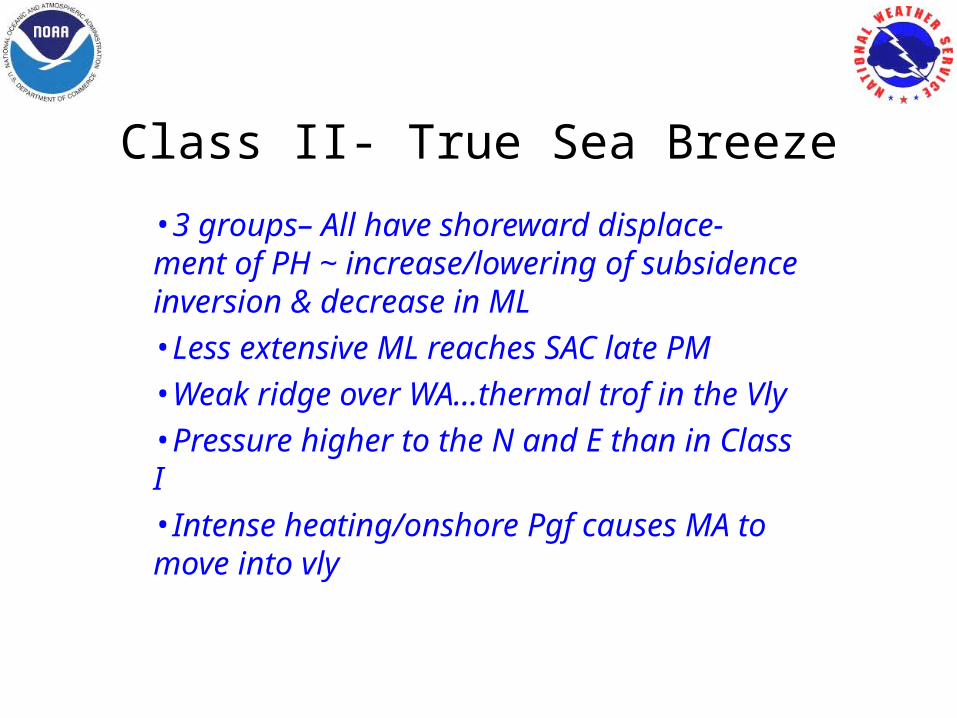
Class II- True Sea Breeze
•3 groups– All have shoreward displace- ment of PH ~ increase/lowering of subsidence inversion & decrease in ML •Less extensive ML reaches SAC late PM•Weak ridge over WA…thermal trof in the Vly•Pressure higher to the N and E than in Class I•Intense heating/onshore Pgf causes MA to move into vly
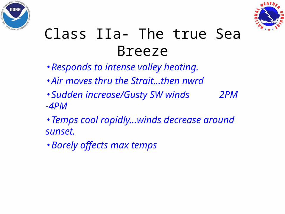
Class IIa- The true Sea Breeze
•Responds to intense valley heating.•Air moves thru the Strait…then nwrd•Sudden increase/Gusty SW winds 2PM -4PM •Temps cool rapidly…winds decrease around sunset. •Barely affects max temps
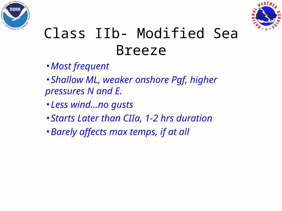
Class IIb- Modified Sea Breeze
•Most frequent•Shallow ML, weaker onshore Pgf, higher pressures N and E. •Less wind…no gusts•Starts Later than CIIa, 1-2 hrs duration•Barely affects max temps, if at all
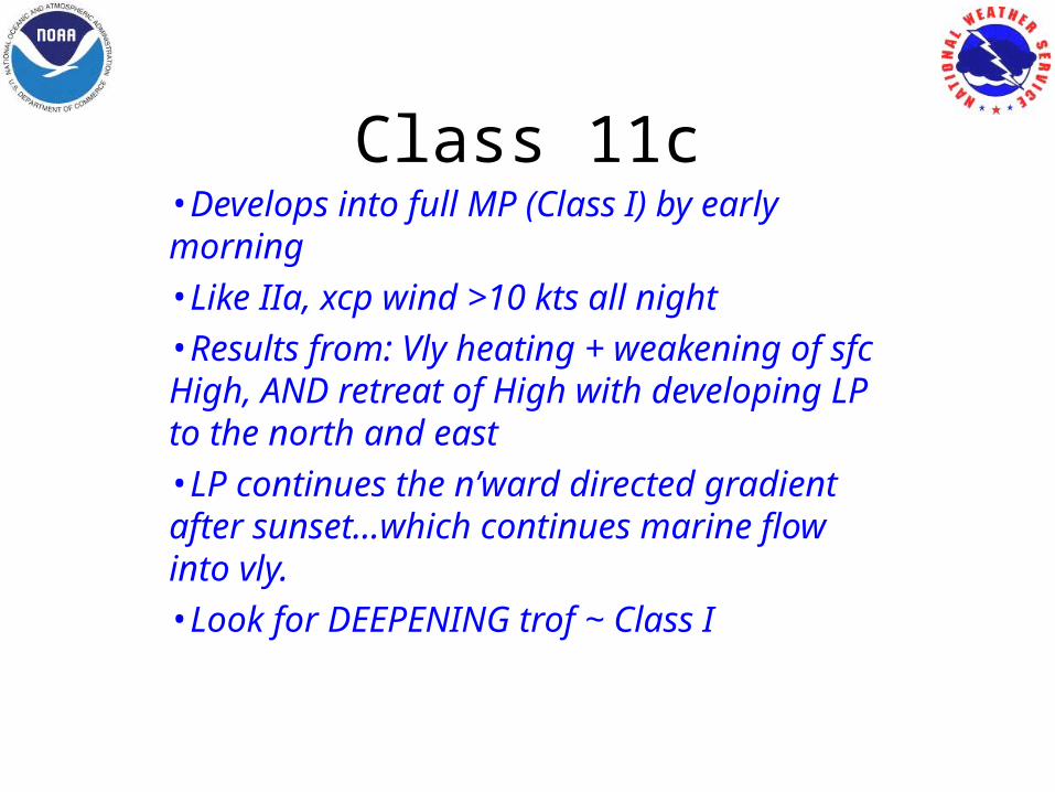
Class 11c•Develops into full MP (Class I) by early morning•Like IIa, xcp wind >10 kts all night•Results from: Vly heating + weakening of sfc High, AND retreat of High with developing LP to the north and east •LP continues the n’ward directed gradient after sunset…which continues marine flow into vly. •Look for DEEPENING trof ~ Class I
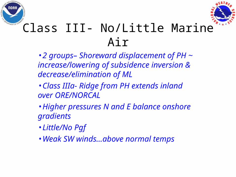
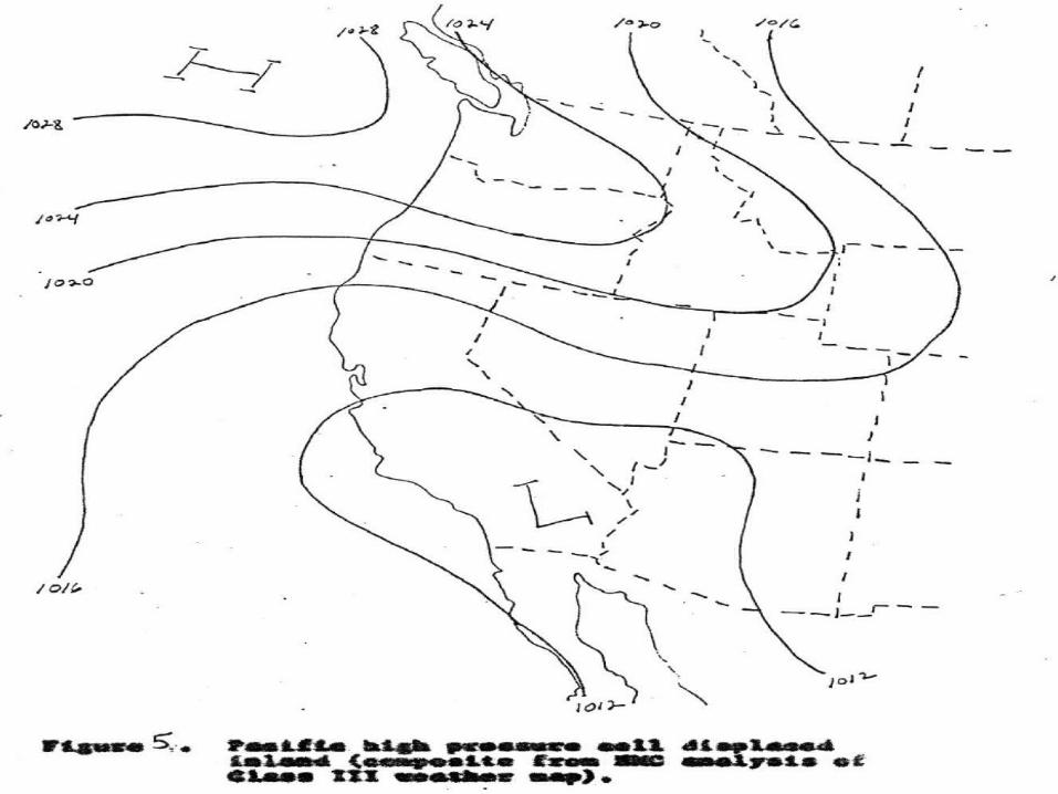
Class III- No/Little Marine Air
•2 groups– Shoreward displacement of PH ~ increase/lowering of subsidence inversion & decrease/elimination of ML •Class IIIa- Ridge from PH extends inland over ORE/NORCAL•Higher pressures N and E balance onshore gradients•Little/No Pgf•Weak SW winds…above normal temps
Class III- No/Little Marine Air
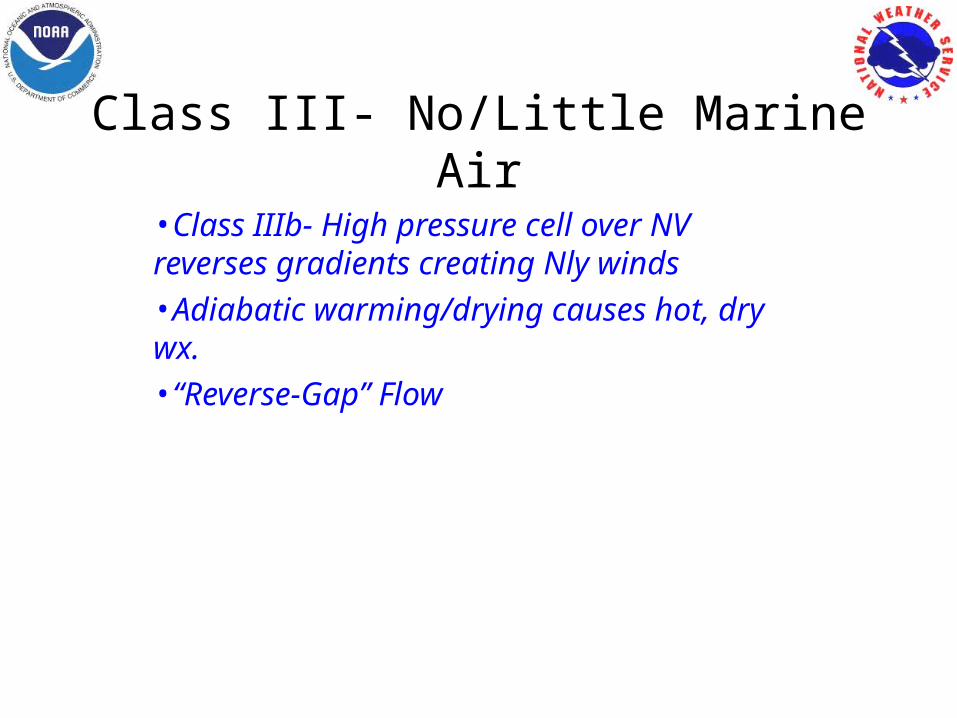
•Class IIIb- High pressure cell over NV reverses gradients creating Nly winds •Adiabatic warming/drying causes hot, dry wx. •“Reverse-Gap” Flow
6 Forecasting Parameters
•PDX-SFO & RNO-SAC Pgfs: + values = no marine penetration. Indicate presence/lack of a ridge over ORE/NV•Depth of the ML (Oak raob) and SUU wind speed (rate of flow)•RBL-SAC Pgf & 24hr 1000-700 mb thickness change: Valley Pgf and potential for CAA (trof aloft)•Calculated # correlates to type of marine intrusion, if any.
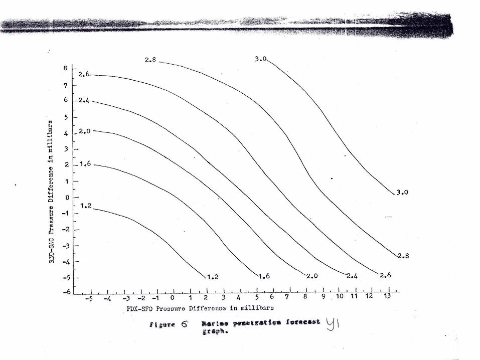
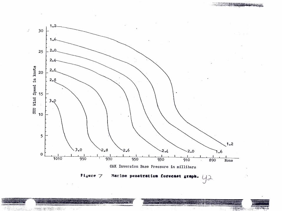
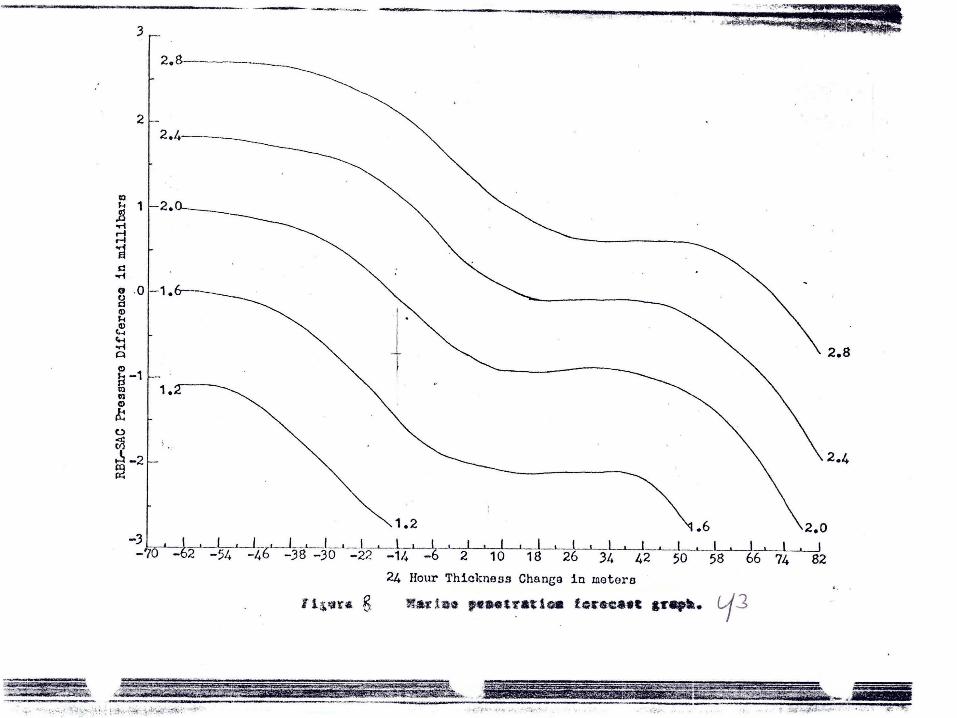
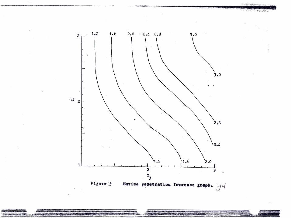
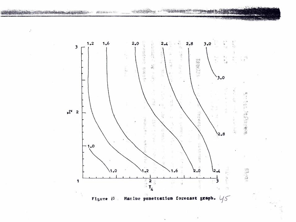
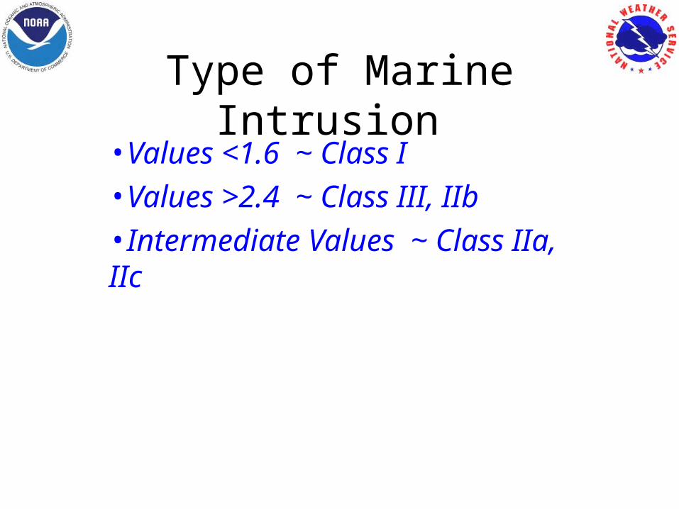
Type of Marine Intrusion •Values <1.6 ~ Class I•Values >2.4 ~ Class III, IIb•Intermediate Values ~ Class IIa, IIc

Some (Forecast) Rules of …….
•“Delta Breeze” begins with >= 1.8 mbs SFO-SAC gradient.•ML depth must be >= 2000 ft to make inland penetration into the valley.•For inland penetration of ML ~ Upper level trof must be “inside” 130W.• Use NAM 925 mbs wind prog, BUFKIT forecast soundings, KDAX VWP to approximate gust potential. •OTHERS??????

“Between the two poles of simplicity and diversity, the searching mind of man remains caught…No matter what he does or what he
invents, there is always nature to teach him a lesson in ............
HUMILITY”
~ H. Riehl

DELTA BREEZE DELTA BREEZE STRATUS STRATUS
INTRUSIONINTRUSION
CASE STUDYCASE STUDY
4-6 AUG 20074-6 AUG 2007

4 AUG 2007 12Z
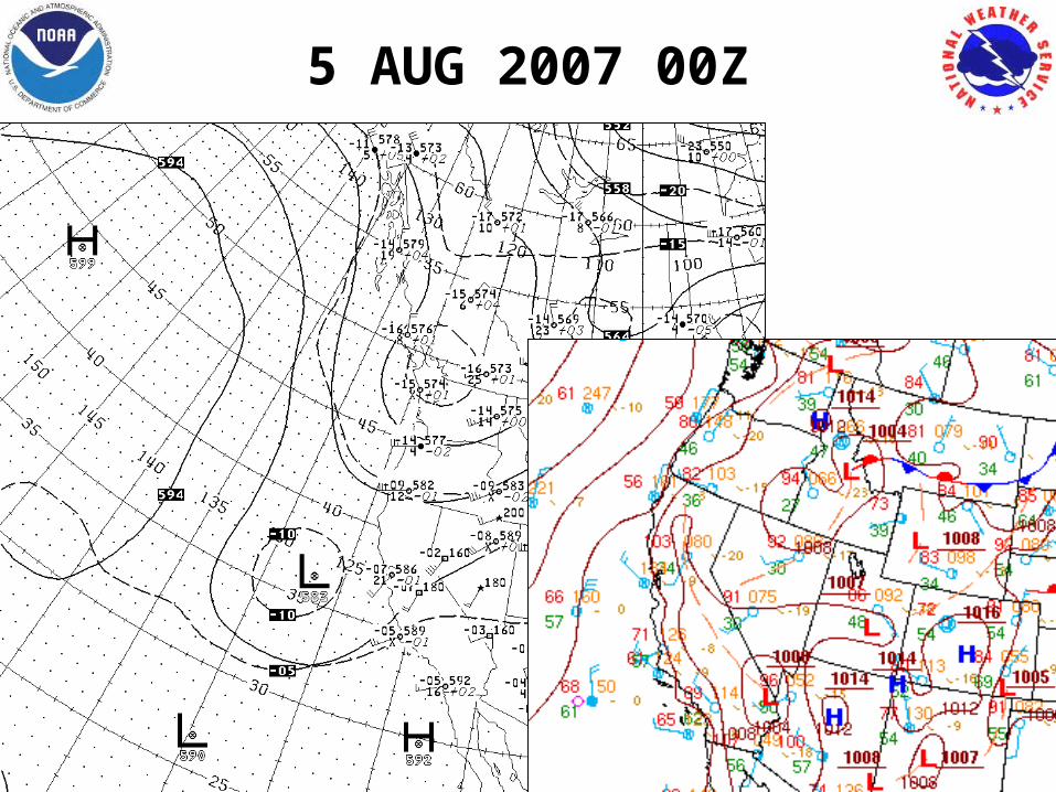
5 AUG 2007 00Z
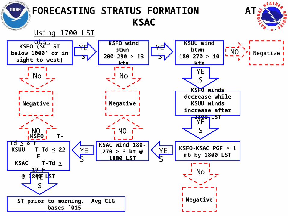
FORECASTING STRATUS FORMATION AT KSAC
Using 1700 LST obs:
KSFO (SCT ST below 1000’ or in sight to west)
YES KSFO wind btwn 200-290 > 13 kts
YES KSUU wind btwn 180-270 > 10 kts
NO Negative
NegativeKSFO winds decrease
while KSUU winds increase after 1800 LST
No YES
YES
KSFO-KSAC PGF > 1 mb by 1800 LST
No
Negative
No
Negative
KSAC wind 180-270 > 3 kt @ 1800 LST
NO
YES YES KSFO T-Td < 8 F
KSUU T-Td < 22 FKSAC T-Td < 19 F
@ 1800 LST
YES
ST prior to morning. Avg CIG bases `015
NO
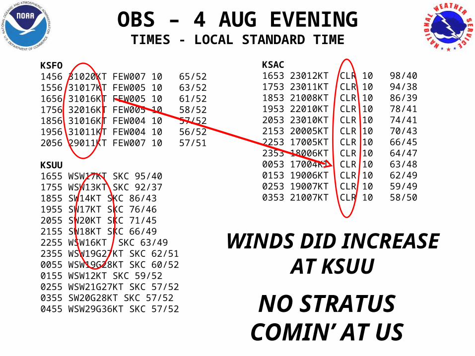
KSFO1456 31020KT FEW007 10 65/52 1556 31017KT FEW005 10 63/52 1656 31016KT FEW005 10 61/52 1756 32016KT FEW005 10 58/52 1856 31016KT FEW004 10 57/52 1956 31011KT FEW004 10 56/52 2056 29011KT FEW007 10 57/51
KSUU1655 WSW17KT SKC 95/401755 WSW13KT SKC 92/371855 SW14KT SKC 86/431955 SW17KT SKC 76/462055 SW20KT SKC 71/452155 SW18KT SKC 66/492255 WSW16KT SKC 63/492355 WSW19G27KT SKC 62/510055 WSW19G28KT SKC 60/520155 WSW12KT SKC 59/520255 WSW21G27KT SKC 57/520355 SW20G28KT SKC 57/52 0455 WSW29G36KT SKC 57/52
OBS – 4 AUG EVENINGTIMES - LOCAL STANDARD TIME
KSAC1653 23012KT CLR 10 98/401753 23011KT CLR 10 94/381853 21008KT CLR 10 86/391953 22010KT CLR 10 78/412053 23010KT CLR 10 74/412153 20005KT CLR 10 70/432253 17005KT CLR 10 66/452353 18006KT CLR 10 64/470053 17004KT CLR 10 63/480153 19006KT CLR 10 62/490253 19007KT CLR 10 59/490353 21007KT CLR 10 58/50
NO STRATUS COMIN’ AT US
WINDS DID INCREASE AT KSUU
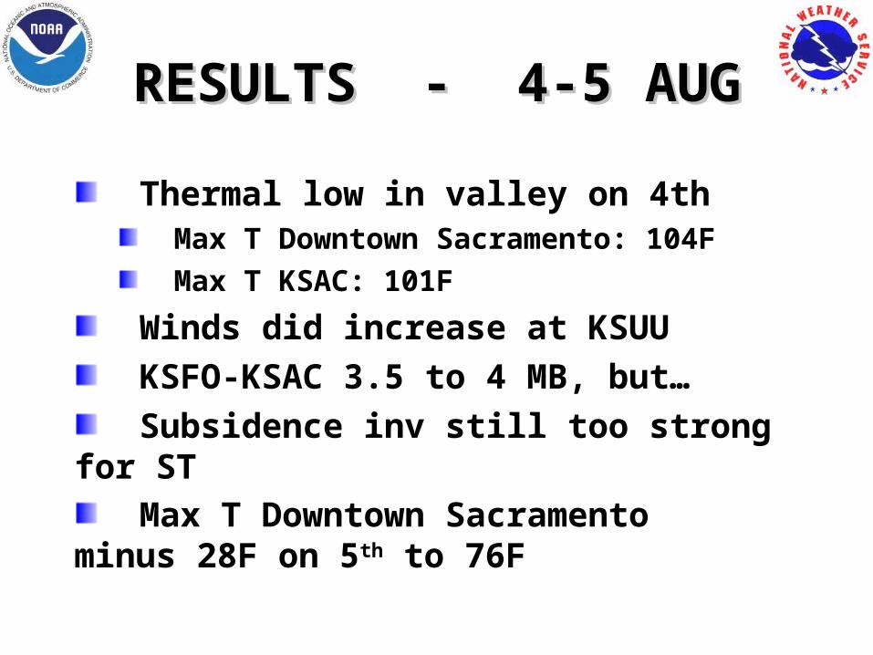
RESULTS - 4-5 AUGRESULTS - 4-5 AUG
Thermal low in valley on 4th Max T Downtown Sacramento: 104F Max T KSAC: 101F
Winds did increase at KSUU KSFO-KSAC 3.5 to 4 MB, but… Subsidence inv still too strong for ST Max T Downtown Sacramento
minus 28F on 5th to 76F
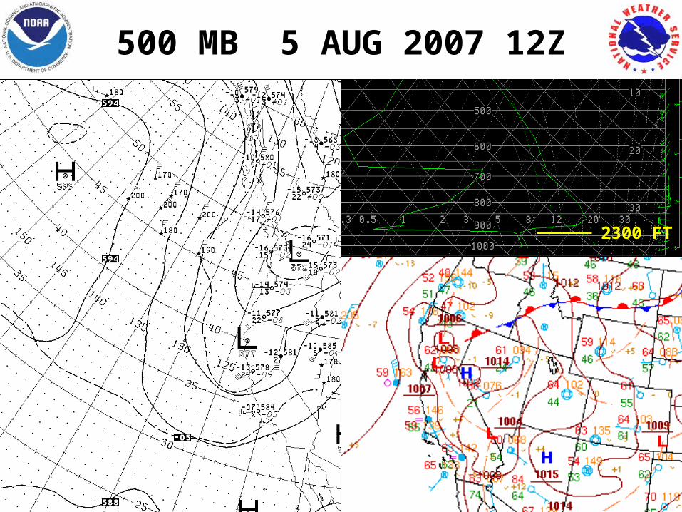
500 MB 5 AUG 2007 12Z
2300 FT
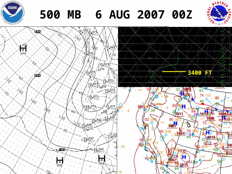
500 MB 6 AUG 2007 00Z
3400 FT

UPPER AIR SOUNDINGS
OAK 6 AUG 12Z
3400 FT

FORECASTING STRATUS FORMATION AT KSAC
Using 1700 LST obs:
KSFO (SCT ST below 1000’ or in sight to west)
YES KSFO wind btwn 200-290 > 13 kts
YES KSUU wind btwn 180-270 > 10 kts
NO Negative
NegativeKSFO winds decrease
while KSUU winds increase after 1800 LST
No YES
YES
KSFO-KSAC PGF > 1 mb by 1800 LST
No
Negative
No
Negative
KSAC wind 180-270 > 3 kt @ 1800 LST
NO
YES YES KSFO T-Td < 8 F
KSUU T-Td < 22 FKSAC T-Td < 19 F
@ 1800 LST
YES
ST prior to morning. Avg CIG bases `015
NO
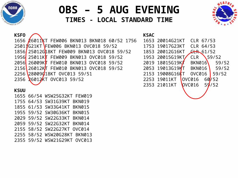
KSFO1656 26011KT FEW006 BKN013 BKN018 60/52 1756 25011G21KT FEW006 BKN013 OVC018 59/52 1856 25012G18KT FEW009 BKN013 OVC018 59/52 1956 25011KT FEW009 BKN013 OVC018 59/52 2056 26009KT FEW010 BKN013 OVC018 59/52 2156 26012KT FEW010 BKN013 OVC018 59/52 2256 28009G18KT OVC013 59/51 2356 26012KT OVC013 59/52
KSUU1655 66/54 WSW25G32KT FEW019 1755 64/53 SW31G39KT BKN019 1855 61/53 SW33G41KT BKN015 1955 59/52 SW30G36KT BKN015 2029 59/52 SW22G33KT BKN014 2059 59/52 SW22G32KT BKN014 2155 58/52 SW22G27KT OVC0142255 58/52 WSW20G28KT BKN0132355 59/52 WSW21G29KT OVC013
KSAC1653 20014G21KT CLR 67/531753 19017G23KT CLR 64/531853 20012G16KT CLR 61/521953 20015G19KT CLR 59/522019 18015G19KT BKN016 59/522053 19013G19KT BKN016 59/522153 19008G16KT OVC016 59/522253 19011KT OVC016 60/522353 21011KT OVC016 59/52
OBS – 5 AUG EVENINGTIMES - LOCAL STANDARD TIME
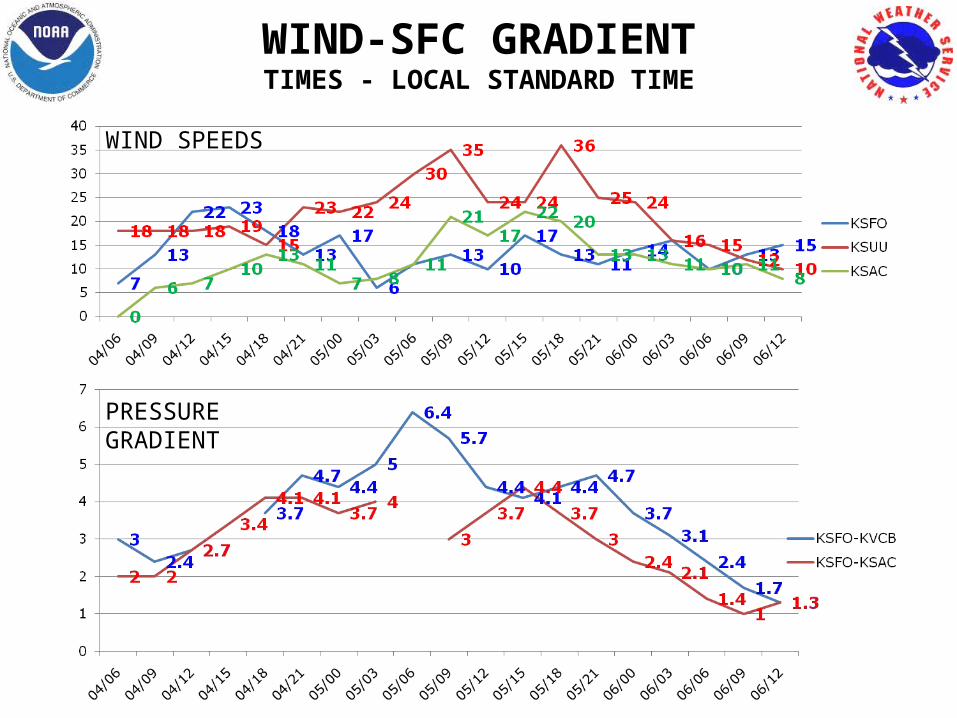
WIND-SFC GRADIENTTIMES - LOCAL STANDARD TIME
WIND SPEEDS
PRESSURE GRADIENT
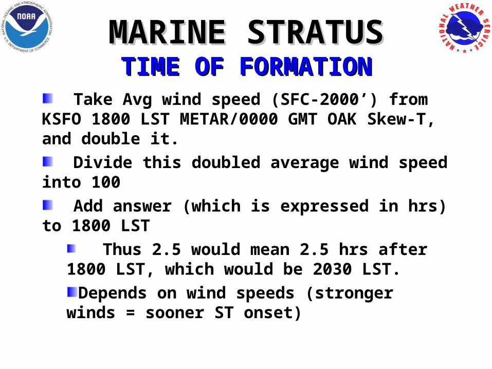
MARINE STRATUSMARINE STRATUSTIME OF FORMATIONTIME OF FORMATION
Take Avg wind speed (SFC-2000’) from KSFO 1800 LST METAR/0000 GMT OAK Skew-T, and double it.
Divide this doubled average wind speed into 100
Add answer (which is expressed in hrs) to 1800 LST
Thus 2.5 would mean 2.5 hrs after 1800 LST, which would be 2030 LST.
Depends on wind speeds (stronger winds = sooner ST onset)
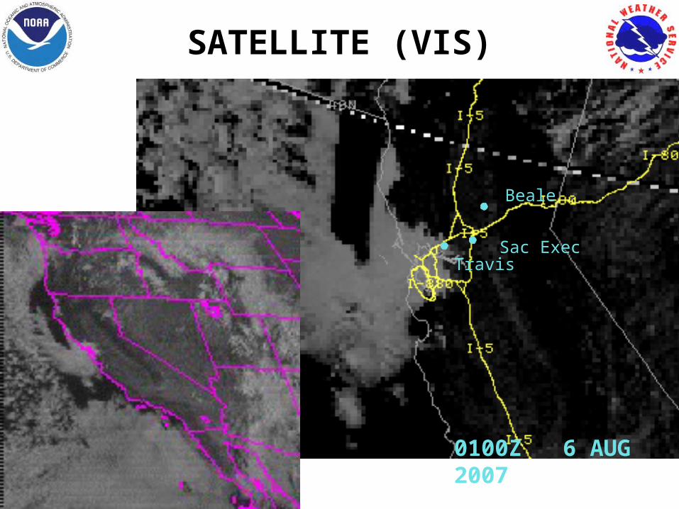
SATELLITE (VIS)
0100Z 6 AUG 2007
Beale
Sac ExecTravis
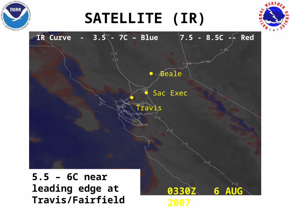
SATELLITE (IR)
0330Z 6 AUG 2007
Sac Exec
Beale
Travis
IR Curve - 3.5 - 7C – Blue 7.5 - 8.5C -- Red
5.5 – 6C near leading edge at Travis/Fairfield
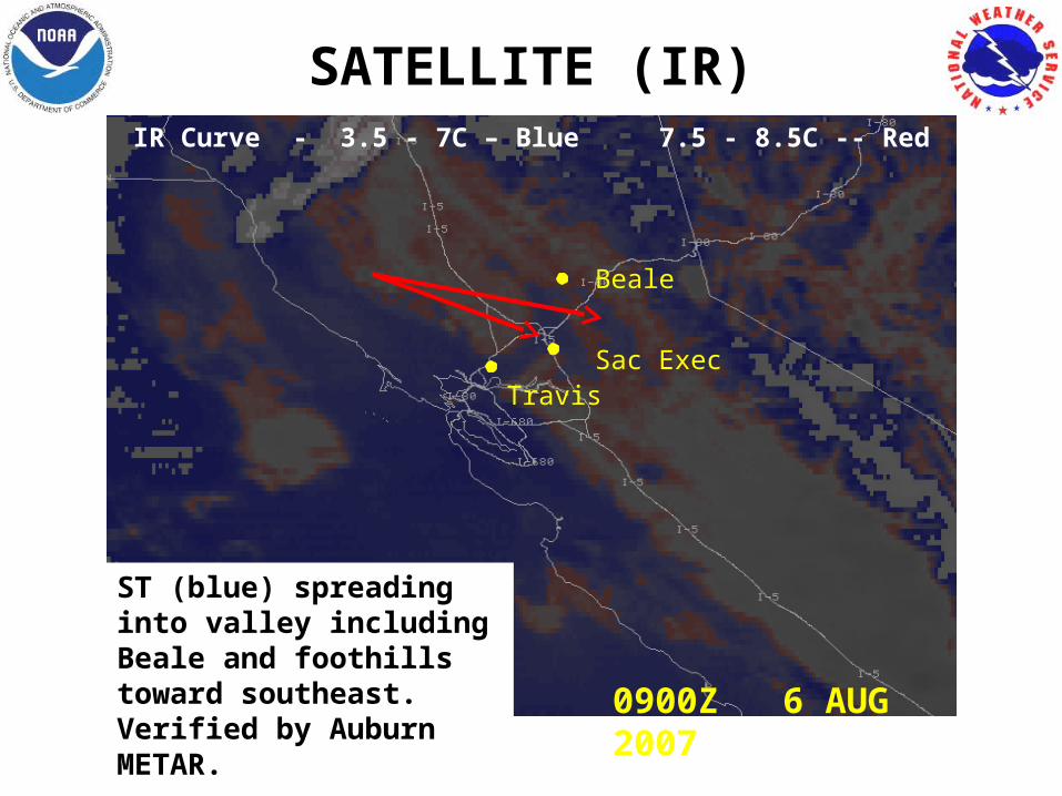
SATELLITE (IR)
0900Z 6 AUG 2007
Sac Exec
Beale
Travis
IR Curve - 3.5 - 7C – Blue 7.5 - 8.5C -- Red
ST (blue) spreading into valley including Beale and foothills toward southeast. Verified by Auburn METAR.
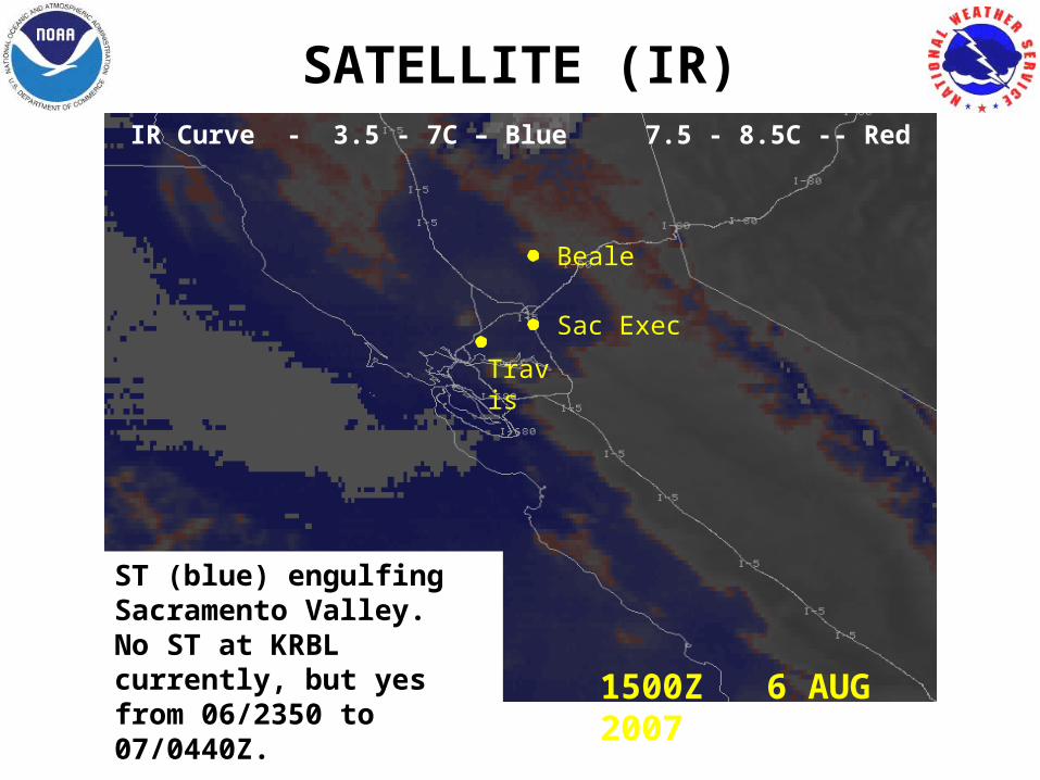
SATELLITE (IR)
1500Z 6 AUG 2007
Travis
Sac Exec
Beale
IR Curve - 3.5 - 7C – Blue 7.5 - 8.5C -- Red
ST (blue) engulfing Sacramento Valley. No ST at KRBL currently, but yes from 06/2350 to 07/0440Z.

SATELLITE (VIS)
1500Z 6 AUG 2007
Beale
Sac ExecTravis
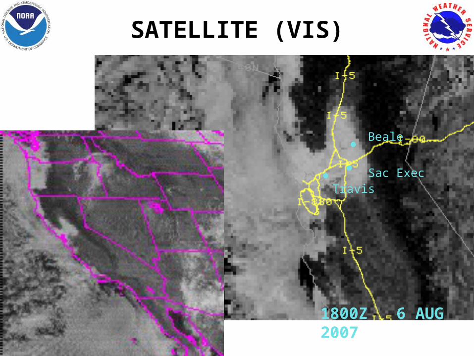
SATELLITE (VIS)
1800Z 6 AUG 2007
Beale
Sac ExecTravis
THAT IS ALLTHAT IS ALL
CASE STUDYCASE STUDY
4-6 AUG 20074-6 AUG 2007


