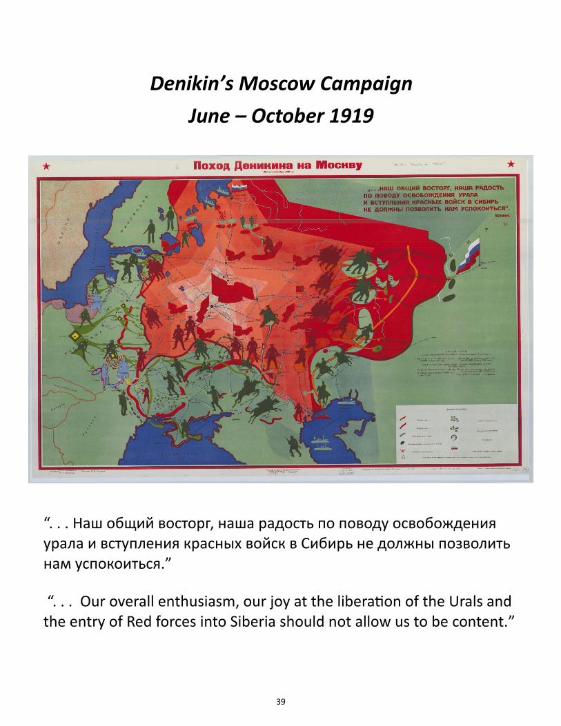
39 “. . . Наш общий восторг, наша радость по поводу освобождения урала и вступления красных войск в Сибирь не должны позволить нам успокоиться.” “. . . Our overall enthusiasm, our joy at the liberaon of the Urals and the entry of Red forces into Siberia should not allow us to be content.” Denikin’s Moscow Campaign June – October 1919
Transcript
39
“. . . Наш общий восторг, наша радость по поводу освобождения урала и вступления красных войск в Сибирь не должны позволить нам успокоиться.”
“. . . Our overall enthusiasm, our joy at the liberation of the Urals and the entry of Red forces into Siberia should not allow us to be content.”
Denikin’s Moscow Campaign
June – October 1919
40
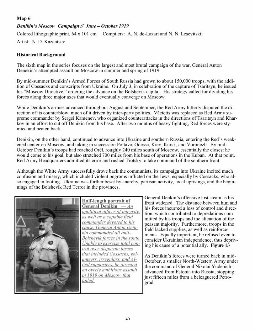
Map 6
Denikin’s Moscow Campaign // June – October 1919
Colored lithographic print, 64 x 101 cm. Compilers: A. N. de-Lazari and N. N. Lesevitskii
Artist: N. D. Kazantsev
Historical Background The sixth map in the series focuses on the largest and most brutal campaign of the war, General Anton Denekin’s attempted assault on Moscow in summer and spring of 1919. By mid-summer Denikin’s Armed Forces of South Russia had grown to about 150,000 troops, with the addi-tion of Cossacks and conscripts from Ukraine. On July 3, in celebration of the capture of Tsaritsyn, he issued his “Moscow Directive,” ordering the advance on the Bolshevik capital. His strategy called for dividing his forces along three major axes that would eventually converge on Moscow. While Denikin’s armies advanced throughout August and September, the Red Army bitterly disputed the di-rection of its counterblow, much of it driven by inter-party politics. Vācietis was replaced as Red Army su-preme commander by Sergei Kamenev, who organized counterattacks in the directions of Tsaritsyn and Khar-kov in an effort to cut off Denikin from his base. After two months of heavy fighting, Red forces were sty-mied and beaten back. Denikin, on the other hand, continued to advance into Ukraine and southern Russia, entering the Red’s weak-ened center on Moscow, and taking in succession Poltava, Odessa, Kiev, Kursk, and Voronezh. By mid-October Denikin’s troops had reached Orël, roughly 240 miles south of Moscow, essentially the closest he would come to his goal, but also stretched 700 miles from his base of operations in the Kuban. At that point, Red Army Headquarters admitted its error and rushed Trotsky to take command of the southern front. Although the White Army successfully drove back the communists, its campaign into Ukraine incited much confusion and misery, which included violent pogroms inflicted on the Jews, especially by Cossacks, who al-so engaged in looting. Ukraine was further beset by anarchy, partisan activity, local uprisings, and the begin-nings of the Bolshevik Red Terror in the provinces.
General Denkin’s offensive lost steam as his front widened. The distance between him and his forces incurred a loss of control and direc-tion, which contributed to depredations com-mitted by his troops and the alienation of the peasant majority. Furthermore, troops in the field lacked supplies, as well as reinforce-ments. Equally important, he refused even to consider Ukrainian independence, thus depriv-ing his cause of a potential ally. Figure 13 As Denikin’s forces were turned back in mid-October, a smaller North-Western Army under the command of General Nikolai Yudenich advanced from Estonia into Russia, stopping just fifteen miles from a beleaguered Petro-grad.
Half-length portrait of General Denikin — An apolitical officer of integrity, as well as a capable field commander devoted to his cause, General Anton Deni-kin commanded all anti-Bolshevik forces in the south. Unable to exercise total con-trol over disparate forces that included Cossacks, vol-unteers, irregulars, and Al-lied supporters, he directed an overly ambitious assault in 1919 on Moscow that failed.
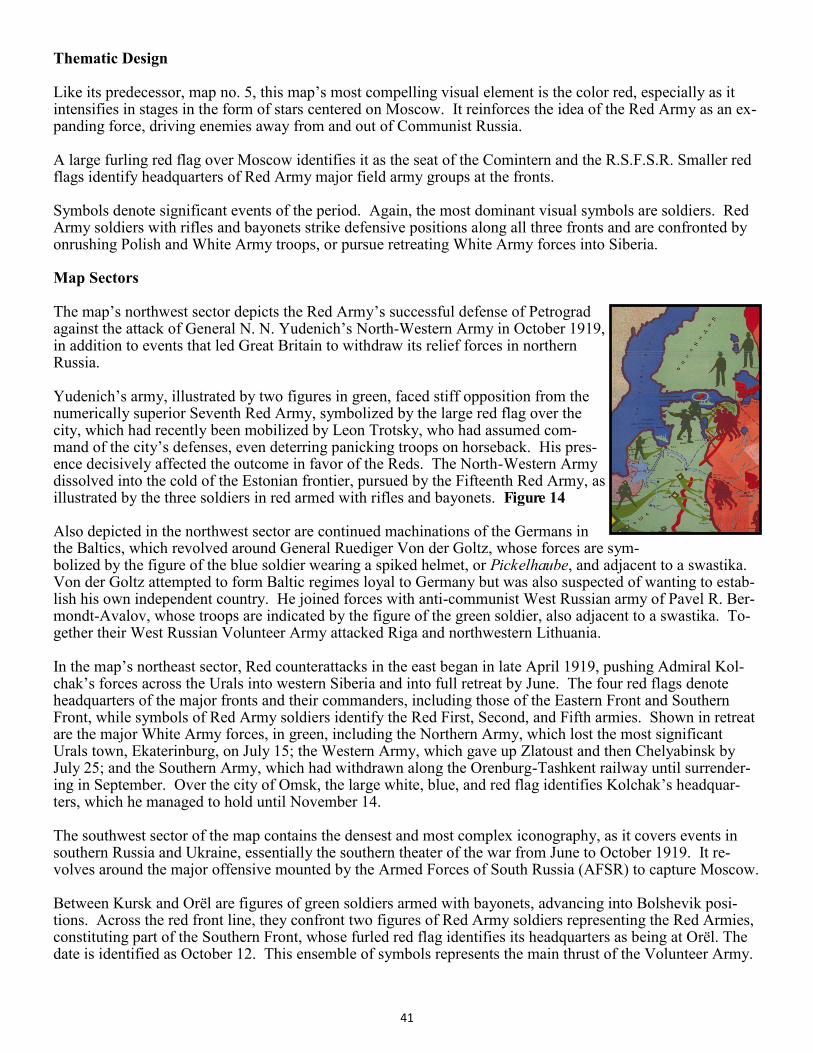
Thematic Design Like its predecessor, map no. 5, this map’s most compelling visual element is the color red, especially as it intensifies in stages in the form of stars centered on Moscow. It reinforces the idea of the Red Army as an ex-panding force, driving enemies away from and out of Communist Russia. A large furling red flag over Moscow identifies it as the seat of the Comintern and the R.S.F.S.R. Smaller red flags identify headquarters of Red Army major field army groups at the fronts. Symbols denote significant events of the period. Again, the most dominant visual symbols are soldiers. Red Army soldiers with rifles and bayonets strike defensive positions along all three fronts and are confronted by onrushing Polish and White Army troops, or pursue retreating White Army forces into Siberia. Map Sectors The map’s northwest sector depicts the Red Army’s successful defense of Petrograd against the attack of General N. N. Yudenich’s North-Western Army in October 1919, in addition to events that led Great Britain to withdraw its relief forces in northern Russia. Yudenich’s army, illustrated by two figures in green, faced stiff opposition from the numerically superior Seventh Red Army, symbolized by the large red flag over the city, which had recently been mobilized by Leon Trotsky, who had assumed com-mand of the city’s defenses, even deterring panicking troops on horseback. His pres-ence decisively affected the outcome in favor of the Reds. The North-Western Army dissolved into the cold of the Estonian frontier, pursued by the Fifteenth Red Army, as illustrated by the three soldiers in red armed with rifles and bayonets. Figure 14 Also depicted in the northwest sector are continued machinations of the Germans in the Baltics, which revolved around General Ruediger Von der Goltz, whose forces are sym-bolized by the figure of the blue soldier wearing a spiked helmet, or Pickelhaube, and adjacent to a swastika. Von der Goltz attempted to form Baltic regimes loyal to Germany but was also suspected of wanting to estab-lish his own independent country. He joined forces with anti-communist West Russian army of Pavel R. Ber-mondt-Avalov, whose troops are indicated by the figure of the green soldier, also adjacent to a swastika. To-gether their West Russian Volunteer Army attacked Riga and northwestern Lithuania. In the map’s northeast sector, Red counterattacks in the east began in late April 1919, pushing Admiral Kol-chak’s forces across the Urals into western Siberia and into full retreat by June. The four red flags denote headquarters of the major fronts and their commanders, including those of the Eastern Front and Southern Front, while symbols of Red Army soldiers identify the Red First, Second, and Fifth armies. Shown in retreat are the major White Army forces, in green, including the Northern Army, which lost the most significant Urals town, Ekaterinburg, on July 15; the Western Army, which gave up Zlatoust and then Chelyabinsk by July 25; and the Southern Army, which had withdrawn along the Orenburg-Tashkent railway until surrender-ing in September. Over the city of Omsk, the large white, blue, and red flag identifies Kolchak’s headquar-ters, which he managed to hold until November 14. The southwest sector of the map contains the densest and most complex iconography, as it covers events in southern Russia and Ukraine, essentially the southern theater of the war from June to October 1919. It re-volves around the major offensive mounted by the Armed Forces of South Russia (AFSR) to capture Moscow. Between Kursk and Orël are figures of green soldiers armed with bayonets, advancing into Bolshevik posi-tions. Across the red front line, they confront two figures of Red Army soldiers representing the Red Armies, constituting part of the Southern Front, whose furled red flag identifies its headquarters as being at Orël. The date is identified as October 12. This ensemble of symbols represents the main thrust of the Volunteer Army.
Figure 12
42
Over right and left bank of the Dnieper River, between Crimea and Chernigov, are an ensemble of symbols, primarily green figures of soldiers, that depict the White attack that took Kiev and Chernigov, as well as part of Ukraine west of the Dnieper, during the summer-fall campaign of 1919. From near Rostov, they proceed-ed rapidly over vast stretches of territory, thus overextending their lines and exposing gaps in the front. Though Denikin selected the Dnieper as a barrier to protect his left flank, it was crossed by one of his generals in an effort to capture Ekaterinoslav. Consequently, White forces advanced into western Ukraine, only to be-come tied up with the hostile partisans, represented by the small green arrows circling in a disoriented fashion. Whites from the Crimea took Kherson, while other forces, green figures of soldiers with bayonets, took Polta-va on July 31, then the Ukrainian capital of Kiev at the end of August, and finally Chernigov and Orel, their furthest point of advance, on October 12. By the end of August, the Ukrainian national army was surrounded by Bolsheviks, Poles, and Whites. Its de-fenses appear as six blue and yellow rectangles, besieged by six red arrows. The Ukrainian formation faced certain defeat after the allied Ukrainian Galician Army formed a separate alliance with Denikin’s Volunteers. Concentrations of Polish power are symbolized by diamond-shaped figures with yellow centers and green bor-ders, accompanied by green figures of armed soldiers. They appear ready to assault right-bank Ukraine, which constituted a significant portion of the former Polish-Lithuanian Commonwealth, which also included present-day Lithuania and Belarus. Polish and Soviet forces clashed over the region throughout 1919-20. Also in Ukraine are a suite of light blue symbols outlined in red: the city of Lviv; the figure of a soldier iden-tified as a Galician; and an arrow advancing towards the figure of Semyon Petliura. These represent elements of the Ukrainian Galician Army, which had been fighting the Poles throughout 1919. In the second half of 1919, it fought against both the Red Army and Denikin’s forces. It became forcibly absorbed into the Red Army in February 1920, when it became the Red Ukrainian Galician Army, which may explain the red out-line. Caught between the green and red front lines in southwestern Ukraine there is a red figure of a soldier firing into the midst of disoriented small green arrows, as well as blue and yellow rectangles. That represents Iona E. Yakir, who became commander of the Southern Group of the Twelfth Red Army in August 1919. In one of the more remarkable episodes of the War, his forces managed to breach the encirclement at Odessa and march 400 kilometers to Zhitomir to fight Petliura’s army and assist in suppressing Makhno’s anarchists. A decorat-ed Soviet officer and innovator in military operations, he was arrested and executed in 1937. In the south, we see a green figure of the lone soldier behind a series of green rectangles along the right bank of the Dniester River. Until the beginning of August 1919, the Romanians faced two communist adversaries: Bolshevik Russia, which threatened its occupation of Bessarabia, and Hungary, with which it had been at war since April. Having invaded and defeated Kun’s communist forces in Hungary, Romania placed forces along the Dniester to prevent the mayhem in southern Ukraine from entering its lands. The southeast sector of the map contains primarily a key to the symbols and statistics. However, it also de-picts British naval operations in the Caspian Sea, as illustrated by three green ships, with the inscription “English material aid to the Ural Cossacks”; a single red ship; three green figures of Cossack cavalrymen de-scending from Uralsk to the north shore of the Caspian; and a line of four circles leading from Gur’ev towards Ural’sk, with the accompanying inscription, “Ural’sk army of Tolstoy.” As part of its Caspian mission, the British navy furnished weapons, and munitions to the roughly 15,000 Cossacks, under the command of V. C. Tolstoy, who had fled from Orenburg to Gur’ev at the entrance of the Ural River on the north Caspian shore. The British had also converted an oil tanker into a makeshift aircraft carrier, from which seaplanes could at-tack the Bolshevik-occupied Russian Fort Alexandrovsk in May. Sorties flown damaged several ships and port facilities, as well as a Red destroyer.
43
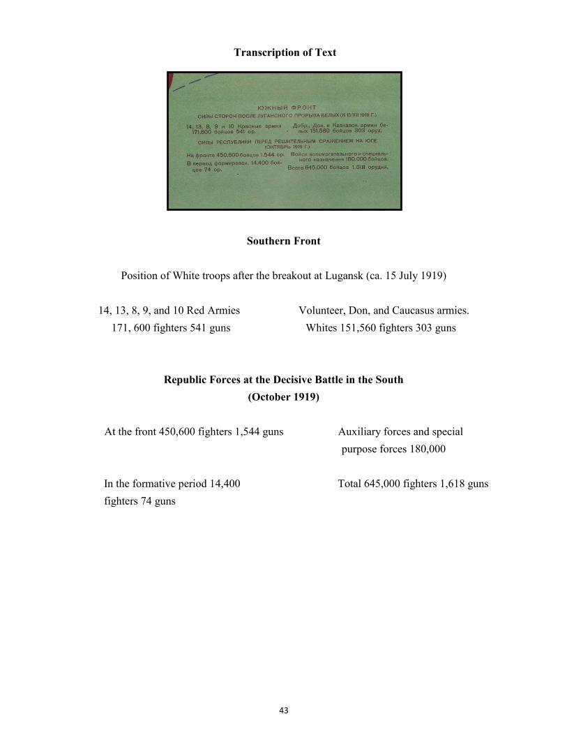
Transcription of Text
Southern Front
Position of White troops after the breakout at Lugansk (ca. 15 July 1919)
14, 13, 8, 9, and 10 Red Armies Volunteer, Don, and Caucasus armies.
Republic Forces at the Decisive Battle in the South
(October 1919)
At the front 450,600 fighters 1,544 guns Auxiliary forces and special
purpose forces 180,000
In the formative period 14,400 Total 645,000 fighters 1,618 guns
fighters 74 guns
44
Conventional Symbols
1. Situation in May. 2. Situation in July. 3. White front lines in August. 4. Red front lines and White situation in October. 5. Rebellions for Soviet power. 6. 25 November The death of many communists in a house explosion arranged by anarchists (on Leontif Lane). 7. Kulak-bandit uprising. 8. Uprising of Orenburg Cossacks. 9. Mamantov’s raid. 10. Transfer of power in the north to General Miller.