Department of Commerce • National Oceanic & Atmospheric Administration • National Weather Service NATIONAL WEATHER SERVICE INSTRUCTION 10-311 January 3, 2018 Operations and Services Marine and Coastal Weather Services, NWSPD 10-3 OFFSHORE, NAVTEX, HIGH SEAS, AND MARINE FORECAST SERVICES NOTICE: This publication is available at: http://www.nws.noaa.gov/directives/. OPR: W/AFS26 (W. Weeks) Certified by: W/AFS26 (A. Allen) Type of Issuance: Routine SUMMARY OF REVISIONS: This instruction supersedes NWSI 10-311, “Offshore, NAVTEX, High Seas, and Marine Forecast Services,” dated December 19, 2014. Changes made to reflect the NWS Headquarters reorganization effective April 1, 2015. Additional changes include: 1. Removed “AFC” in (previous) page A-6. 2. Modified in Appendix A "120 Hour Sea Ice Forecast" to "5-Day Sea Ice Forecast." 3. Added 36 Hour Wind/Wave forecast to page A-3, 00Z section. 4. Removed “OPC/PAC Tropical Cyclone Danger Area” from page A-5. 5. Removed “Sea State Surface Analysis” from pg A-1, 00Z section; changed pg 1, 12Z section to “Full Basin Sea State Surface Analysis.” 6. Page A-2, changed “Sea State Analysis” to “Full Basin Sea State Analysis.” 7. Added “24 Hour 500 mb Forecast” to pg A-2 for 00Z cycle & pg A-3, for 12Z cycle. 8. Added “Surface Analysis” and “Wind / Wave Analysis” for 18Z cycle on page A-3. 9. 5.3.3.b.1, changed “tropical and subtropical cyclones” to “tropical warnings.” 10. 5.3.3.b.1, line 2, changed to “potential, subtropical or tropical cyclone, or tropical storm, or hurricane…” 11. 5.3.3.b.1, line 2, changed “cyclone’s strength” to, “system type.” 12. 5.3.3.b.1, Tropical Storm and Hurricane changed to “Tropical Storm or Hurricane warning.” 13. 5.3.3.b.1, tropical cyclone “category” changed to tropical cyclone “warning type.” 14. 5.3.3b.7, added “per forecaster discretion,” and sentence that begins “Tropical warnings associated with Potential Tropical Cyclones (TCs) should be ranked based on the severity…” 15. Updated 5.4 - figure 4 to put the CCODE below the date/time line (as shown in 5.5.1). 16. Added an extra-tropical hurricane force section to 5.5.1. 17. Remove mention of HSFEP3 from 5.4 - figure 4, 5.5.1, and 5.5.2. 18. Adjusted the CCODE in the EPI example in Appendix B (page B-15). Signed 12/20/2017 Andrew D. Stern Date Director Analyze, Forecast and Support Office
Transcript
Department of Commerce • National Oceanic & Atmospheric Administration • National Weather Service NATIONAL WEATHER SERVICE INSTRUCTION 10-311
January 3, 2018
Operations and Services Marine and Coastal Weather Services, NWSPD 10-3
OFFSHORE, NAVTEX, HIGH SEAS, AND MARINE FORECAST SERVICES
NOTICE: This publication is available at: http://www.nws.noaa.gov/directives/.
OPR: W/AFS26 (W. Weeks) Certified by: W/AFS26 (A. Allen) Type of Issuance: Routine
SUMMARY OF REVISIONS: This instruction supersedes NWSI 10-311, “Offshore, NAVTEX, High Seas, and Marine Forecast Services,” dated December 19, 2014. Changes made to reflect the NWS Headquarters reorganization effective April 1, 2015. Additional changes include: 1. Removed “AFC” in (previous) page A-6. 2. Modified in Appendix A "120 Hour Sea Ice Forecast" to "5-Day Sea Ice Forecast." 3. Added 36 Hour Wind/Wave forecast to page A-3, 00Z section. 4. Removed “OPC/PAC Tropical Cyclone Danger Area” from page A-5. 5. Removed “Sea State Surface Analysis” from pg A-1, 00Z section; changed pg 1, 12Z section
to “Full Basin Sea State Surface Analysis.” 6. Page A-2, changed “Sea State Analysis” to “Full Basin Sea State Analysis.” 7. Added “24 Hour 500 mb Forecast” to pg A-2 for 00Z cycle & pg A-3, for 12Z cycle. 8. Added “Surface Analysis” and “Wind / Wave Analysis” for 18Z cycle on page A-3. 9. 5.3.3.b.1, changed “tropical and subtropical cyclones” to “tropical warnings.” 10. 5.3.3.b.1, line 2, changed to “potential, subtropical or tropical cyclone, or tropical storm, or
hurricane…” 11. 5.3.3.b.1, line 2, changed “cyclone’s strength” to, “system type.” 12. 5.3.3.b.1, Tropical Storm and Hurricane changed to “Tropical Storm or Hurricane warning.” 13. 5.3.3.b.1, tropical cyclone “category” changed to tropical cyclone “warning type.” 14. 5.3.3b.7, added “per forecaster discretion,” and sentence that begins “Tropical warnings
associated with Potential Tropical Cyclones (TCs) should be ranked based on the severity…” 15. Updated 5.4 - figure 4 to put the CCODE below the date/time line (as shown in 5.5.1). 16. Added an extra-tropical hurricane force section to 5.5.1. 17. Remove mention of HSFEP3 from 5.4 - figure 4, 5.5.1, and 5.5.2. 18. Adjusted the CCODE in the EPI example in Appendix B (page B-15). Signed 12/20/2017 Andrew D. Stern Date Director Analyze, Forecast and Support Office
NWSI 10-311 JANUARY 3, 2018
2
Offshore, NAVTEX, High Seas, and Marine Forecast Services Table of Contents Page
Appendix A NWS Official Graphic Products and Valid Times ............................................ A-1 Appendix B : Examples of NWS Offshore, MIM, NAVTEX, and High Seas Forecasts ..... B-1
Figure 1: Offshore Waters Forecast (OFF) Format ..................................................................... 13 Figure 2: Unscheduled Offshore Waters Forecast (OFF) Format ............................................... 14 Figure 3: NAVTEX Forecast Format .......................................................................................... 18 Figure 4: High Seas Forecast (HSF) Format ................................................................................ 24
NWSI 10-311 JANUARY 3, 2018
5
Introduction 1This procedural instruction provides product specifications for the main alphanumeric and graphical offshore and high seas weather products issued by four National Weather Service (NWS) Weather Forecast Offices (WFOs), and the National Centers for Environmental Prediction (NCEP), including the Ocean Prediction Center (OPC), and the Tropical Analysis and Forecast Branch (TAFB) of the National Hurricane Center (NHC). The WFOs which prepare text offshore forecasts are: WFO Honolulu, HI (HFO), WFO Anchorage, AK (AFC), WFO Fairbanks (AFG), and WFO Juneau, AK (AJK).
2 Offshore Waters Forecast (product category OFF)
2.1 Mission Connection The Offshore Waters Forecast (OFF) provides forecast and warning information to mariners who travel on the oceanic waters adjacent to the U.S., its territorial coastal waters and the Caribbean Sea. The OFF, produced in both graphic and alphanumeric format, serves users who operate from the coastal waters out several hundred nautical miles from shore. OPC and TAFB also produce the OFF in gridded format.
2.2 Issuance Guidelines
2.2.1 Creation Software WFOs will produce the OFF using the Advanced Weather Interactive Processing System (AWIPS) software formatters. The Interactive Forecast Preparation System (IFPS) Graphical Forecast Editor (GFE) application formatting tools will be used for generation of product content.
2.2.2 Issuance Criteria The Alaska Region will issue the OFF at least twice a day with updates as necessary. TAFB, OPC, and WFO HFO, will issue the OFF four times daily at regular intervals, with updates as necessary.
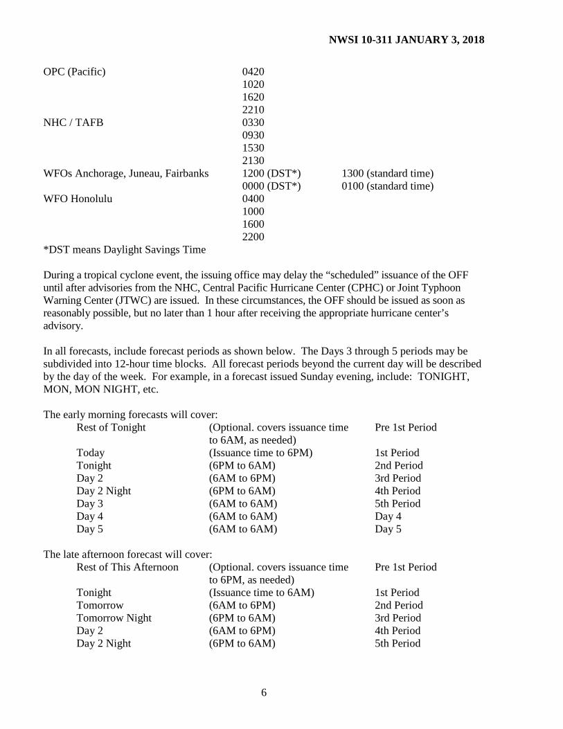
2.2.3 Issuance Time OFFs are routinely-scheduled products. Forecasters should make the OFF available to users by the scheduled issuance time, but no earlier than one (1) hour before this issuance time. In the communications header, list the issuance time in Coordinated Universal Time (UTC), but in the mass media header, list the valid time in local time. National Centers and WFOs should issue OFFs based on the following, except during tropical cyclone events, when the routine issuance time may be delayed: Responsible Office Issuance Times (UTC) Scheduled Scheduled Issuance Issuance OPC (Atlantic) 0320 0920 1520 2120
*DST means Daylight Savings Time During a tropical cyclone event, the issuing office may delay the “scheduled” issuance of the OFF until after advisories from the NHC, Central Pacific Hurricane Center (CPHC) or Joint Typhoon Warning Center (JTWC) are issued. In these circumstances, the OFF should be issued as soon as reasonably possible, but no later than 1 hour after receiving the appropriate hurricane center’s advisory. In all forecasts, include forecast periods as shown below. The Days 3 through 5 periods may be subdivided into 12-hour time blocks. All forecast periods beyond the current day will be described by the day of the week. For example, in a forecast issued Sunday evening, include: TONIGHT, MON, MON NIGHT, etc. The early morning forecasts will cover:
Rest of Tonight (Optional. covers issuance time Pre 1st Period to 6AM, as needed)
Today (Issuance time to 6PM) 1st Period Tonight (6PM to 6AM) 2nd Period Day 2 (6AM to 6PM) 3rd Period Day 2 Night (6PM to 6AM) 4th Period Day 3 (6AM to 6AM) 5th Period Day 4 (6AM to 6AM) Day 4 Day 5 (6AM to 6AM) Day 5 The late afternoon forecast will cover: Rest of This Afternoon (Optional. covers issuance time Pre 1st Period to 6PM, as needed) Tonight (Issuance time to 6AM) 1st Period Tomorrow (6AM to 6PM) 2nd Period Tomorrow Night (6PM to 6AM) 3rd Period Day 2 (6AM to 6PM) 4th Period Day 2 Night (6PM to 6AM) 5th Period
NWSI 10-311 JANUARY 3, 2018
7
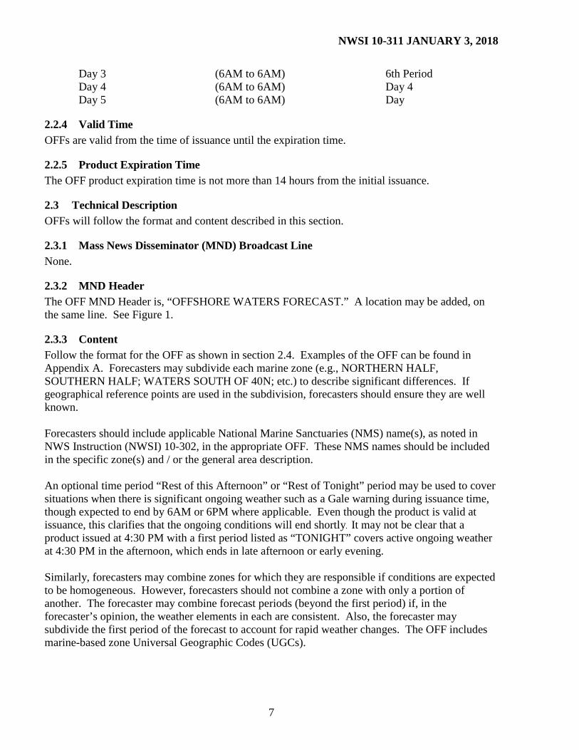
Day 3 (6AM to 6AM) 6th Period Day 4 (6AM to 6AM) Day 4 Day 5 (6AM to 6AM) Day
2.2.4 Valid Time OFFs are valid from the time of issuance until the expiration time.
2.2.5 Product Expiration Time The OFF product expiration time is not more than 14 hours from the initial issuance.
2.3 Technical Description OFFs will follow the format and content described in this section.
2.3.1 Mass News Disseminator (MND) Broadcast Line None.
2.3.2 MND Header The OFF MND Header is, “OFFSHORE WATERS FORECAST.” A location may be added, on the same line. See Figure 1.
2.3.3 Content Follow the format for the OFF as shown in section 2.4. Examples of the OFF can be found in Appendix A. Forecasters may subdivide each marine zone (e.g., NORTHERN HALF, SOUTHERN HALF; WATERS SOUTH OF 40N; etc.) to describe significant differences. If geographical reference points are used in the subdivision, forecasters should ensure they are well known. Forecasters should include applicable National Marine Sanctuaries (NMS) name(s), as noted in NWS Instruction (NWSI) 10-302, in the appropriate OFF. These NMS names should be included in the specific zone(s) and / or the general area description. An optional time period “Rest of this Afternoon” or “Rest of Tonight” period may be used to cover situations when there is significant ongoing weather such as a Gale warning during issuance time, though expected to end by 6AM or 6PM where applicable. Even though the product is valid at issuance, this clarifies that the ongoing conditions will end shortly. It may not be clear that a product issued at 4:30 PM with a first period listed as “TONIGHT” covers active ongoing weather at 4:30 PM in the afternoon, which ends in late afternoon or early evening. Similarly, forecasters may combine zones for which they are responsible if conditions are expected to be homogeneous. However, forecasters should not combine a zone with only a portion of another. The forecaster may combine forecast periods (beyond the first period) if, in the forecaster’s opinion, the weather elements in each are consistent. Also, the forecaster may subdivide the first period of the forecast to account for rapid weather changes. The OFF includes marine-based zone Universal Geographic Codes (UGCs).
NWSI 10-311 JANUARY 3, 2018
8
Above the synopsis, OFF products will include a statement that explains the seas forecast as the significant wave height which is the average of the highest 1/3 of the waves, and that individual waves may be more than twice as high. Offices issuing OFFs for areas with significant sea ice coverage may choose to cease forecasts when the zone becomes mostly covered. The threshold for determining when the zone forecast should be started and ended will be determined by the WFO and Regional headquarters according to partner and user needs.
2.3.4 Synopsis The synopsis for the OFF should be a concise, understandable description of the significant surface weather features that may cause significant winds and seas over the forecast area during the forecast period. Areas in the tropics often have significant upper level features which are the dominant cause of the weather, e.g., TUTTs (Tropical Upper Tropospheric Troughs) and upper level lows. The synopsis may mention these features. Forecasters should concentrate on the first 48 hours. At a minimum, the synopsis should identify major weather systems and the strength, trend, and movement of each. After 48 hours, less detail is needed; include a general description of systems impacting the area especially if they are expected to generate gale force, storm force, or hurricane force winds. Such systems do not necessarily have to be located within the forecast area. Marine synopses for the high seas and offshore forecasts and Marine Weather Discussions (MIMs) may use descriptive terms for winds and seas consistent with the Beaufort scale as shown in the NWS glossary (http://www.weather.gov/glossary/). For tropical cyclones expected to impact the forecast area, forecasters should include forecast positions out to 72 hours with a generalized position description at 96 and 120 hours. In accordance with NWSI 10-601, it is highly recommended the following caveat be included in the synopsis: “Forecast winds in and near active tropical cyclones should be used with caution due to uncertainty in forecast track, size, and intensity.” When a volcano near an offshore zone has a confirmed eruption, or is in a heightened active state, it should be briefly mentioned in the synopsis. The volcano should be identified by name and location (example: the latitude / longitude position, and / or mountain range, and / or a distance from a major population center). If the volcano is in a heightened level of unrest, the specific threat level may be included. If the volcano has recently erupted, state the most recent eruption time and if ash or debris have been reported or are suspected on the ocean surface in the offshore area. Confirmation of eruption or threat level attribution may be given to the appropriate volcano observatory (example: Alaska Volcano Observatory or Cascades Volcano Observatory). Forecasters may also include the appropriate office name and phone number or High Frequency (HF) radio frequency to request mariner reports. It is imperative that any mention about volcanic activity in an offshore product first be coordinated with the WFO responsible for neighboring coastal waters areas.
NWSI 10-311 JANUARY 3, 2018
9
Examples: MOUNT RAINIER VOLCANO [AT POSITION 46.8N 121.7W] [IN THE CASCADE MOUNTAIN RANGE OF WASHINGTON] [60 NM SE OF TACOMA] IS CURRENTLY IN A STATE OF UNREST AND COULD ERUPT WITH LITTLE NOTICE. MARINERS TRAVELING IN THE VICINITY OF MOUNT RAINIER ARE URGED TO EXERCISE CAUTION. IF MARINERS ENCOUNTER VOLCANIC ASH OR FLOATING VOLCANIC DEBRIS…YOU ARE ENCOURAGED TO REPORT THE OBSERVATION WITH THE OCEAN PREDICTION CENTER BY CALLING 301-683-1520. THE ALASKA VOLCANO OBSERVATORY CONFIRMED OKMOK VOLCANO [AT POSITION 53.4N 168.2W] [IN THE CENTRAL ALEUTIAN ISLANDS] [70 NM SW OF DUTCH HARBOR] HAS ERUPTED AT 1437 UTC 9 FEBRUARY. VOLCANIC ASH MAY BE REACHING THE SURFACE NEAR/IN THE VICINITY OF UMNAK ISLAND. ASH HAS BEEN REPORTED ON THE SURFACE OF THE OCEAN 30 NM S OF UMNAK ISLAND. MARINERS SHOULD EXERCISE CAUTION. IF MARINERS ENCOUNTER VOLCANIC ASH OR FLOATING VOLCANIC DEBRIS…YOU ARE ENCOURAGED TO REPORT THE OBSERVATION TO THE KODIAK WEATHER SERVICE OFFICE AT 907-487-9730 OR HF RADIO CALL SIGN KWL38.
2.3.5 Headlines Use headlines to emphasize weather events likely to have a significant impact on mariners or marine operations. In each headline, indicate the severity of the event in the priority order given below. The most significant headline should generally stand alone. However, forecasters may include more than one headline to indicate multiple hazards or worsening conditions. Do not include a headline that downgrades a current condition in later periods (e.g., a storm warning in effect improving to a gale warning). Refer to the NWS definitions in NWSI 10-303 for appropriate definitions of gale, storm, and hurricane force wind warnings. In the headline, forecasters should include a general statement of the threat, the time period, and, if necessary, the specific area impacted. Do not include headlines for severe local storm watches and warnings, tropical cyclone watches, and small craft advisories in the OFF. However, forecasters may use other headlines, such as “WARNING POSSIBLE WED” or “GALE FORCE WINDS POSSIBLE WED”, especially for stronger storms in later forecast periods. a. Non-Tropical Cyclone Related Headlines. In the OFF, forecasters should use the following headlines, in the priority order given, if appropriate criteria are occurring or are expected to be met. For Gale, Storm and Hurricane Force Wind Warnings, NWS offices responsible for the OFF will issue warnings when wind criteria are forecast for the first two twelve (12) hour periods (for the first 24 hours), and may issue warnings through the fourth period when forecaster confidence is high. In addition, when forecaster confidence is high, marine offices may include a headline in the
NWSI 10-311 JANUARY 3, 2018
10
OFF such as “GALE FORCE (or GALE FORCE CONDITIONS or STORM FORCE or HURRICANE FORCE WINDS) POSSIBLE xxxDAY,” for the remaining periods of the forecast. 1. Hurricane Force Wind Warning 2. Storm Warning 3. Gale Warning 4. Heavy Freezing Spray Warning 5. Volcanic Ashfall Advisory In accordance with NWSI 10-310, in situations where winds gust frequently above advisory / warning thresholds, forecasters should use discretion in issuing advisories or warnings, as appropriate, to alert users and partners to hazardous marine conditions. Gusts occurring on a time-scale greater than two hours are considered frequent. Gusts should not be included in the forecast unless they are expected to be at least 15 knots (KT) greater than the sustained wind. Based on event significance, forecasters may include headlines for events expected to impact the forecast area such as freezing spray, restrictions lowering visibilities below 1/4 nautical mile (NM), or ashfall from volcanoes. b. Tropical Cyclone Related Headlines. For Tropical Storm and Hurricane Warnings, NWS offices responsible for the OFF will issue appropriate warnings when wind criteria are forecast for the first 36 hours (if forecaster confidence is high, 48 hours) based on forecast information contained in the appropriate tropical cyclone advisories. c. Volcanic Ash Headlines. Forecasters should include an Ashfall Advisory headline without the word “WARNING” if a confirmed volcanic eruption could significantly impact marine operations in the given offshore zone.
2.3.6 1-3 Day Forecast Periods In the OFF product, include specific wind and sea states for all periods in the 1 through 3 Day forecasts. Forecasters should also include major precipitation events, ice accretion, ashfall, and low visibility conditions as conditions warrant. The preferred wording uses the GFE and the text formatters. The formatters will create probabilistic wording for the specific forecast periods in the body of the forecast when appropriate. Example: .TUE...TROPICAL STORM CONDITIONS POSSIBLE. W WINDS 25 TO 30 KT. SEAS 10 TO 15 FT.
2.3.7 4-5 Day Forecast Periods Include the wind and sea height information in the 4 through 5 Day forecast periods. Forecasters may also note other major events such as ice accretion and low visibility. When a tropical cyclone threatens to impact an OFF zone, forecasters should include an indication of the tropical cyclone, based on NHC, CPHC, and / or Weather Prediction Center (WPC)
NWSI 10-311 JANUARY 3, 2018
11
guidance, for the specific day(s) impacted. Because large positional and intensity errors are possible in these cases, forecasts should not use specific wind and sea values. The preferred way to accomplish the wording is through the use of the GFE and the text formatters. The formatters will create probabilistic wording for the specific forecast periods in the body of the forecast when appropriate. Example: .SUN…HURRICANE CONDITIONS POSSIBLE.
2.3.8 OFF - Forecast Parameters a. Winds. Winds represent predominant conditions at 10 meters above the surface of the water. Forecasters should give directions to eight points of the compass and speeds rounded to the nearest 5 KT. Forecast changes in wind direction should be for changes of 45 degrees or more, and forecast changes in wind speed should be for changes of 10 knots or more. Wind speed transition terms such as “INCREASING” and “DIMINISHING” and direction transition terms such as “BECOMING” and “SHIFTING” should be used to add clarity to the forecast trends. The terms “VEERING, BACKING, BECOMING, SHIFTING,” or “RISING” may be used when appropriate, but not “DECREASING.” Transition terms will end in an “-ing,” e.g., Do not use the term “BECOME,” “INCREASE,” or “SHIFT.” When there are significant differences expected between sustained winds and gusts, the OFF should contain either a specific wind gust speed or a more generic phrase to describe the gusty condition of the winds, e.g., “E WINDS TO 70 KT WITH GUSTS TO 85 KT.”; “WITH HIGHER GUSTS.” Gusts should not be included in the forecast unless they are expected to be at least 15 KT greater than the sustained wind. Note significant changes (i.e., at a minimum, those changes denoting a change in warning category) in the winds during the forecast period. b. Seas. Give sea state as significant wave height or broken into appropriate components (e.g., “WIND WAVES 2 TO 4 FT”, “NORTHEAST SWELL TO 10 FT”, “SEAS 12 FT”). Whenever a SWELL is specified, include the direction from which the swell is propagating, to 8 points of the compass. NCEP marine centers will provide a range of seas in their OFFs, i.e., 4 TO 6 FT or 10 TO 15 FT. When upper values in the range exceed double the lower value of the sea heights, a qualifier may be added to express the region where the highest seas are located. Example: SEAS 10 TO 22 FT...HIGHEST SEAS N OF 28N BETWEEN 50W AND 65W. Forecasters should not use descriptive terms, such as MODERATE or ROUGH. Sea state forecasts should be included for marine areas or portions of marine areas not covered by ice. For other marine areas where coverage of 7/10 or more of sea ice is expected, forecasts of sea
NWSI 10-311 JANUARY 3, 2018
12
state are usually omitted; however, if the area has at least 10% contiguous open water, sea state forecasts may be given. In these cases, use the phrase “SEAS IN ICE FREE WATERS.” c. Significant Weather / Visibility. When it is expected, forecasters should include significant weather posing a hazard to navigation (i.e., widespread fog or other restriction lowering visibilities to 1/4 NM or less, or thunderstorms). Based on forecaster discretion, and/or expected impact to users, forecasters may include obstructions to visibility ranging between 1 ½ NM to 5 NM. Forecasters may use areal coverage terms like “patchy,” “widespread,” or “areas of” to describe fog or other significant weather. Forecasters may use precipitation probability terms “CHANCE”, “OCCASIONAL”, etc., as defined in NWSI 10-204, and may include specific visibility distances. However, forecasters should not include sky cover. d. Icing. The forecaster should include freezing spray in the body of the forecast whenever ice accretion on exposed surfaces is likely. When freezing spray is forecast to meet warning thresholds, a headline should also be included (e.g., HEAVY FREEZING SPRAY WARNING...). An ice accretion rate of 2 centimeters (cm) / hour or greater is considered heavy freezing spray. See definitions in NWSI 10-303.
2.3.9 Coordination and Collaboration Offices and centers with adjoining or overlapping areas of responsibility should coordinate and collaborate to ensure products are consistent and compatible. This effort includes communication with appropriate governmental forecast agencies outside the United States. Forecasters should refer to Section 5, Digital Forecast Collaboration, of NWSI 10-201, National Digital Forecast Database and Local Database Description and Specifications, for detailed information on the coordination and collaboration processes for gridded forecasts and analyses, available at: http://www.nws.noaa.gov/directives/sym/pd01002001curr.pdf.
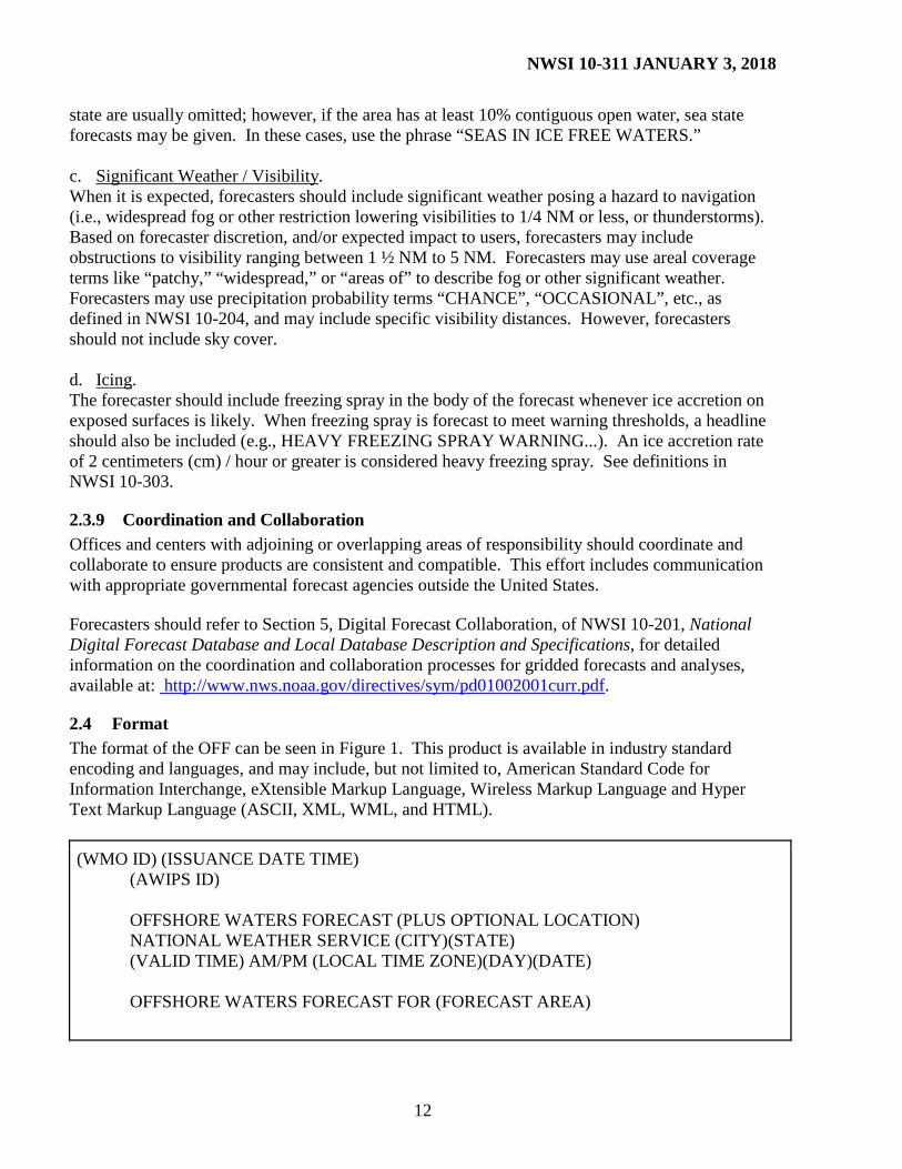
2.4 Format The format of the OFF can be seen in Figure 1. This product is available in industry standard encoding and languages, and may include, but not limited to, American Standard Code for Information Interchange, eXtensible Markup Language, Wireless Markup Language and Hyper Text Markup Language (ASCII, XML, WML, and HTML).
(WMO ID) (ISSUANCE DATE TIME) (AWIPS ID) OFFSHORE WATERS FORECAST (PLUS OPTIONAL LOCATION) NATIONAL WEATHER SERVICE (CITY)(STATE) (VALID TIME) AM/PM (LOCAL TIME ZONE)(DAY)(DATE) OFFSHORE WATERS FORECAST FOR (FORECAST AREA)
NWSI 10-311 JANUARY 3, 2018
13
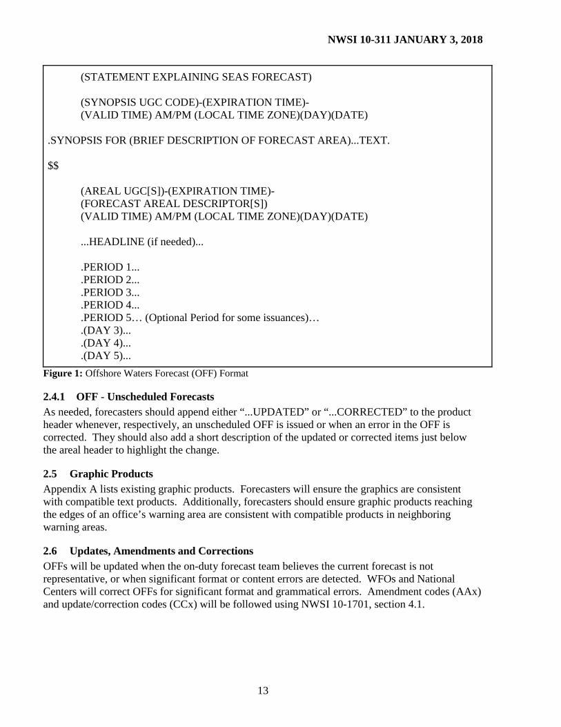
(STATEMENT EXPLAINING SEAS FORECAST) (SYNOPSIS UGC CODE)-(EXPIRATION TIME)- (VALID TIME) AM/PM (LOCAL TIME ZONE)(DAY)(DATE) .SYNOPSIS FOR (BRIEF DESCRIPTION OF FORECAST AREA)...TEXT. $$ (AREAL UGC[S])-(EXPIRATION TIME)- (FORECAST AREAL DESCRIPTOR[S]) (VALID TIME) AM/PM (LOCAL TIME ZONE)(DAY)(DATE) ...HEADLINE (if needed)... .PERIOD 1... .PERIOD 2... .PERIOD 3... .PERIOD 4... .PERIOD 5… (Optional Period for some issuances)… .(DAY 3)... .(DAY 4)... .(DAY 5)...
Figure 1: Offshore Waters Forecast (OFF) Format
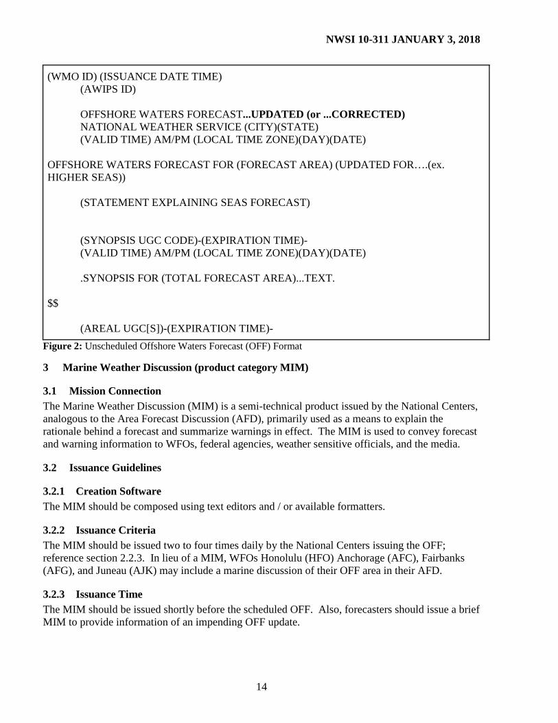
2.4.1 OFF - Unscheduled Forecasts As needed, forecasters should append either “...UPDATED” or “...CORRECTED” to the product header whenever, respectively, an unscheduled OFF is issued or when an error in the OFF is corrected. They should also add a short description of the updated or corrected items just below the areal header to highlight the change.
2.5 Graphic Products Appendix A lists existing graphic products. Forecasters will ensure the graphics are consistent with compatible text products. Additionally, forecasters should ensure graphic products reaching the edges of an office’s warning area are consistent with compatible products in neighboring warning areas.
2.6 Updates, Amendments and Corrections OFFs will be updated when the on-duty forecast team believes the current forecast is not representative, or when significant format or content errors are detected. WFOs and National Centers will correct OFFs for significant format and grammatical errors. Amendment codes (AAx) and update/correction codes (CCx) will be followed using NWSI 10-1701, section 4.1.
NWSI 10-311 JANUARY 3, 2018
14
(WMO ID) (ISSUANCE DATE TIME) (AWIPS ID) OFFSHORE WATERS FORECAST...UPDATED (or ...CORRECTED) NATIONAL WEATHER SERVICE (CITY)(STATE) (VALID TIME) AM/PM (LOCAL TIME ZONE)(DAY)(DATE) OFFSHORE WATERS FORECAST FOR (FORECAST AREA) (UPDATED FOR….(ex. HIGHER SEAS)) (STATEMENT EXPLAINING SEAS FORECAST) (SYNOPSIS UGC CODE)-(EXPIRATION TIME)- (VALID TIME) AM/PM (LOCAL TIME ZONE)(DAY)(DATE) .SYNOPSIS FOR (TOTAL FORECAST AREA)...TEXT. $$ (AREAL UGC[S])-(EXPIRATION TIME)-
Figure 2: Unscheduled Offshore Waters Forecast (OFF) Format
3.1 Mission Connection The Marine Weather Discussion (MIM) is a semi-technical product issued by the National Centers, analogous to the Area Forecast Discussion (AFD), primarily used as a means to explain the rationale behind a forecast and summarize warnings in effect. The MIM is used to convey forecast and warning information to WFOs, federal agencies, weather sensitive officials, and the media.
3.2 Issuance Guidelines
3.2.1 Creation Software The MIM should be composed using text editors and / or available formatters.
3.2.2 Issuance Criteria The MIM should be issued two to four times daily by the National Centers issuing the OFF; reference section 2.2.3. In lieu of a MIM, WFOs Honolulu (HFO) Anchorage (AFC), Fairbanks (AFG), and Juneau (AJK) may include a marine discussion of their OFF area in their AFD.
3.2.3 Issuance Time The MIM should be issued shortly before the scheduled OFF. Also, forecasters should issue a brief MIM to provide information of an impending OFF update.
NWSI 10-311 JANUARY 3, 2018
15
3.2.4 Valid Time MIMs are valid from time of release until the next complete update.
3.2.5 Product Expiration Time MIMs do not contain a product expiration time.
3.3 Technical Description The MIM will follow the format and content described in this section.
3.3.1 UGC Type There is no UGC coding associated with the MIM product.
3.3.2 MND Broadcast Line None.
3.3.3 MND Header The MND Header is “MARINE WEATHER DISCUSSION”.
3.3.4 Content The MIM should describe synoptic and mesoscale features expected to affect areas in and adjacent to offshore waters in both the Atlantic and Pacific Oceans. This narrative describes weather, wind speeds, and seas through the next five days. The MIM should emphasize timing and issuance of warnings; include future trends of wind and sea conditions, effects of currents such as the Gulf Stream in the Atlantic Ocean, and how the latest computer model guidance is handling features of significance to the mariner. The MIM may include the degree of confidence for any forecast element which would benefit coastal WFOs and other users’ decision making. MIMs may use descriptive terms for winds and seas consistent with the Beaufort scale as shown in the NWS glossary: (http://www.weather.gov/glossary/).
3.4 Format The MIM should be consistent with instructions for the AFD contained in NWSI 10-503. Examples of the MIM can be found in Appendix A. This product is available in industry standard encoding and languages, and may include, but not limited to, ASCII, XML, WML and HTML.
3.5 Updates, Amendments and Corrections MIMs will be updated when the on-duty forecast team believes the current forecast is not representative, or when format or content errors are detected. Issuing offices will correct MIMs for format and grammatical errors when discovered.
4 NAVTEX Forecasts
4.1 Mission Connection The NAVTEX acronym is derived from NAVigational information TEleprinter EXchange. NAVTEX forecasts support the international SOLAS (Safety of Life At Sea) convention of the
NWSI 10-311 JANUARY 3, 2018
16
International Maritime Organization (IMO). The NAVTEX forecast is a text forecast issued to accommodate broadcast restrictions of the U.S. Coast Guard NAVTEX transmitters. NAVTEX forecasts provide forecast and warning information to mariners who travel on the oceanic waters adjacent to the U.S. and its territorial coastal waters, and serves users who operate from the coastal waters up to 200 NM from shore. The NAVTEX should include the highest winds and seas, and associated warnings for the respective broadcast area.
4.2 Issuance Guidelines
4.2.1 Creation Software WFOs and National Center offices should use text editors and/or available formatters to compose the NAVTEX forecast.
4.2.2 Issuance Criteria The NAVTEX forecast represents a combination of the Coastal Waters Forecast (CWF) and the OFF. However, those offices issuing the CWF and the OFF will retain full responsibility for those products.
4.2.3 Issuance Time The NAVTEX forecast will be issued immediately following the OFF transmittal.
4.2.4 Valid Time NAVTEX Forecasts are valid from the time of issuance until the expiration time.
4.2.5 Product Expiration Time The NAVTEX forecast expiration time is not more than 14 hours from the initial issuance.
4.3 Technical Description NAVTEX forecasts will follow the format and content described in this section.
4.3.1 MND Broadcast Line None.
4.3.2 MND Header The NAVTEX marine products are broadcast via U.S. Coast Guard (USCG) NAVTEX stations. Refer to NWSI 10-302, section 4, NAVTEX Forecast Areas of Responsibility, for detailed description of areas. For the NAVTEX first MND line use: NAVTEX MARINE FORECAST [+ optional area description] The 2nd line should be one line only, in accordance with NWSI 10-1701, section 4.2.3: Issuing Office
NWSI 10-311 JANUARY 3, 2018
17
The 3rd line should be in accordance with NWSI 10-1701, section 4.2.4: Time / Date No extraneous lines, e.g., "INCLUDING THE STELLWAGEN BANK NATIONAL MARINE SANCTUARY.” A general area description should not be included immediately below the MND lines.
4.3.3 Content NAVTEX forecasts will include the same content as the CWF and the OFF. Exceptions: Do not include UGCs. In each NAVTEX forecast, match the broadcast areas of the appropriate USCG transmitters as listed in NWSI 10-302. Forecasters may combine forecast periods if weather features are similar. No NAVTEX forecast will be longer than 89 lines including blank lines. Include the phrase: “...PLEASE REFER TO DETAILED COASTAL WATERS FORECASTS (CWF) AVAILABLE THROUGH NOAA WEATHER RADIO AND OTHER SOURCES” before the synopsis.
4.3.4 Synopsis The synopsis should be consistent with synopses contained in the CWF and the OFF.
4.3.5 Headlines Forecasters should list applicable headlines from both CWFs and OFFs in the NAVTEX forecast, including those involving the extended portion of the forecast. Exception: Forecasters should not include headlines for small craft advisories or for severe local storm watches and warnings. Append the annotation ‘WITHIN XX NM OF SHORE’ for items restricted to coastal waters areas, where XX is the appropriate distance of the restricted item.
4.3.6 1-2 Day Forecast Periods Include conditions representing values found throughout the entire forecast area.
4.3.7 3-5 Day Forecast Periods Include winds and seas only. Local policy may include significant weather (i.e., thunderstorms, freezing spray) in days 3-5.
4.3.8 NAVTEX - Forecast Parameters In the NAVTEX forecast, include the same forecast parameters as forecast in the OFF and the CWF.
4.4 Format This product is available in industry standard encoding and languages, which may include, but are not limited to, ASCII, XML, WML and HTML. To ensure proper dissemination of the NAVTEX forecast, follow the following format:
NWSI 10-311 JANUARY 3, 2018
18
(WMO ID) (ISSUANCE DATE TIME) (AWIPS ID) NAVTEX MARINE FORECAST (PLUS OPTIONAL LOCATION) NATIONAL WEATHER SERVICE (CITY)(STATE) -example of alternative text for line 2: NWS OCEAN PREDICTION CENTER WASHINGTON DC (See NWSI 10-1701) (SCHEDULED ISSUANCE TIME) AM/PM (LOCAL TIME ZONE)(DAY)(DATE) ... PLEASE REFER TO DETAILED COASTAL WATERS FORECASTS (CWF) AVAILABLE THROUGH NOAA WEATHER RADIO AND OTHER SOURCES... .SYNOPSIS...(TEXT). (FORECAST AREA[S]) ...HEADLINE(S) (if necessary)... .PERIOD 1... .PERIOD 2... .PERIOD 3... .PERIOD 4... .PERIOD 5… (Optional Period for some issuances)… .(DAY 3)… .(DAY 3 NIGHT)… .(DAY 4)... .(DAY 4 NIGHT)… .(DAY 5)... .(DAY 5 NIGHT)... $$ FORECASTER NAME (Optional)
Figure 3: NAVTEX Forecast Format
4.4.1 NAVTEX - Unscheduled Forecasts. Update NAVTEX forecasts only in the rare circumstance when a major modification is required. During a tropical cyclone event, the issuing office may delay the “scheduled” issuance of the NAVTEX until after advisories from the NHC, CPHC or JTWC are issued. In these circumstances, the NAVTEX should be issued as soon as reasonably possible, but no later than 1 hour after receiving the appropriate hurricane center’s advisory.
NWSI 10-311 JANUARY 3, 2018
19
4.5 Updates, Amendments and Corrections As NAVTEX is a single frequency system, each NAVTEX station and content provider takes measures to prevent mutual interference with other stations. To avoid such mutual interference, each NAVTEX station is assigned specific time slots. When a NAVTEX broadcast may exceed the assigned broadcast period, or broadcast a warning at an unscheduled time, the NAVTEX station schedules arrangements with nearby stations to prevent potential mutual interference. Such rescheduling of broadcasts may result in an undesirable cascade effect, inhibiting the fundamental purpose of the NAVTEX system. Therefore, unscheduled broadcasts, and lengthy forecasts should be avoided. When changes are necessary, amendment codes (AAx) and update/correction codes (CCx) will be followed using NWSI 10-1701, section 4.1.
5 High Seas Forecast (product category HSF) The areas of high seas forecasts are explicitly defined by the World Meteorological Organization (WMO) and will not be modified without prior coordination with NWS Headquarters Analyze, Forecast, and Support Office. The OPC, TAFB, and WFO Honolulu (HFO) are the HSF issuing offices of the NWS.
5.1 Mission Connection The HSF provides warning and forecast information to mariners who travel on the oceanic waters. The NWS provides forecasts in our area of responsibility for mariners of the High Seas in both graphic and alphanumeric format.
5.2 Issuance Guidelines
5.2.1 Creation Software OPC, TAFB and WFO HFO should produce the HSF using text editors where automated software formatters are not yet available.
5.2.2 Issuance Criteria The HSF will be issued every six hours, including any marine warnings for gale, storm, and tropical cyclone conditions. Refer to NWSI 10-302, section 5, for a description of the areas covered in these forecasts.
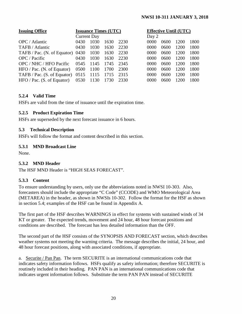
5.2.3 Issuance Time HSFs are routinely-scheduled products. OPC, TAFB and WFO HFO should issue HSFs based on the following:
NWSI 10-311 JANUARY 3, 2018
20
Issuing Office Issuance Times (UTC) Effective Until (UTC) Current Day Day 2 OPC / Atlantic 0430 1030 1630 2230 0000 0600 1200 1800 TAFB / Atlantic 0430 1030 1630 2230 0000 0600 1200 1800 TAFB / Pac. (N. of Equator) 0430 1030 1630 2230 0000 0600 1200 1800 OPC / Pacific 0430 1030 1630 2230 0000 0600 1200 1800 OPC / NHC / HFO Pacific 0545 1145 1745 2345 0000 0600 1200 1800 HFO / Pac. (N. of Equator) 0500 1100 1700 2300 0000 0600 1200 1800 TAFB / Pac. (S. of Equator) 0515 1115 1715 2315 0000 0600 1200 1800 HFO / Pac. (S. of Equator) 0530 1130 1730 2330 0000 0600 1200 1800
5.2.4 Valid Time HSFs are valid from the time of issuance until the expiration time.
5.2.5 Product Expiration Time HSFs are superseded by the next forecast issuance in 6 hours.
5.3 Technical Description HSFs will follow the format and content described in this section.
5.3.1 MND Broadcast Line None.
5.3.2 MND Header The HSF MND Header is “HIGH SEAS FORECAST”.
5.3.3 Content To ensure understanding by users, only use the abbreviations noted in NWSI 10-303. Also, forecasters should include the appropriate “C Code” (CCODE) and WMO Meteorological Area (METAREA) in the header, as shown in NWSIs 10-302. Follow the format for the HSF as shown in section 5.4; examples of the HSF can be found in Appendix A. The first part of the HSF describes WARNINGS in effect for systems with sustained winds of 34 KT or greater. The expected trends, movement and 24 hour, 48 hour forecast positions and conditions are described. The forecast has less detailed information than the OFF. The second part of the HSF consists of the SYNOPSIS AND FORECAST section, which describes weather systems not meeting the warning criteria. The message describes the initial, 24 hour, and 48 hour forecast positions, along with associated conditions, if appropriate. a. Securite / Pan Pan. The term SECURITE is an international communications code that indicates safety information follows. HSFs qualify as safety information; therefore SECURITE is routinely included in their heading. PAN PAN is an international communications code that indicates urgent information follows. Substitute the term PAN PAN instead of SECURITE
NWSI 10-311 JANUARY 3, 2018
21
whenever winds of 64 KT or greater are in the forecast within 48 hours. The wind speed of 64 KT is the determining factor, not the phenomenon (i.e., a hurricane or non-tropical storm) generating them. b. Warnings. Forecasters should include individual paragraphs listed by category of warning (hurricane, tropical storm, hurricane force wind, storm, gale, freezing spray, or volcano). In each paragraph, include a synopsis taken from, as applicable, the latest synoptic surface analysis or the latest tropical cyclone forecast/advisory from the NHC or CPHC showing the following:
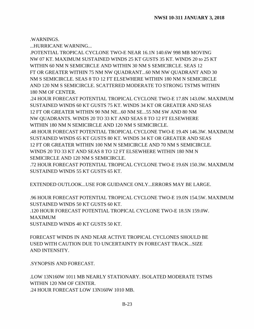
1. For tropical warnings, forecasters should provide the appropriate warning headline (i.e., HURRICANE WARNING...), the cyclone’s system type (potential, subtropical or tropical cyclone, or tropical storm, or hurricane), and its identifier (name or number). The HSF will not include headlines for Tropical Depressions. Tropical Depressions will be included in the Synopsis and Forecast section if the initial, 24, and 48 hour forecast are below Tropical Storm or Hurricane warning status.
The headline will be the highest tropical cyclone warning type for the 48 hour forecast. Forecasters may include forecast points out to 120 hours for tropical cyclones when conditions warrant and for which consistent guidance is available. In accordance with NWSI 10-601, it is highly recommended the following caveat be included in the warning section: “Forecast winds in and near active tropical cyclones should be used with caution due to uncertainty in forecast track, size, and intensity.”
2. For all extratropical cyclones,
a. Location of the center (in whole degrees of latitude and longitude); b. Central pressure (in millibars (mb)); c. For each quadrant, the areal coverage (in NM from the center) of the various wind
categories (storm, gale, etc.) and associated seas greater than 12 feet; d. Direction (eight points of the compass), speed of movement (KT), and trend in
movement and / or intensity.
3. The central pressure (in mb) expected at 24 hours; include the tropical cyclone name.
4. The central pressure (in mb) expected at 48 hours; include the tropical cyclone name.
5. For non-tropical systems, initial and forecast locations of fronts and troughs associated with such warnings.
6. For Icing. When appropriate, include a headline for HEAVY FREEZING SPRAY in the HSF. An ice accretion rate of 2 cm / hour or greater is considered heavy freezing spray. See definitions in NWSI 10-303.
7. For Volcanic Ashfall Advisories. Forecasters should include an Ashfall Advisory headline
without the word “WARNING” if there is a confirmed volcanic eruption or a volcano is in
NWSI 10-311 JANUARY 3, 2018
22
a state of heightened unrest which could significantly impact marine operations. If issued, include in the paragraph the name of the volcano, its location (the latitude / longitude position, and / or mountain range, and / or a distance from a major population center). If there was an eruption, state, “Xxxxx Volcano erupted” (where “Xxxxx” is the name of the volcano) and the most recent eruption time. If volcanic ash or debris has been reported on the surface of the ocean, include this in the advisory text, as well as the appropriate office name and phone number for further reports. It is imperative that any high seas headlines and statements about volcanic activity are coordinated with the WFO responsible for overlapping coastal waters areas.
Example: …ASHFALL ADVISORY… OKMOK VOLCANO AT POSITION 53.4N 168.2W IN THE CENTRAL ALEUTIAN ISLANDS 70 NM SW OF DUTCH HARBOR HAS ERUPTED AT 1437 UTC 9 FEBRUARY 2009. VOLCANIC ASH MAY BE REACHING THE SURFACE NEAR/IN THE VICINITY OF UMNAK ISLAND. ASH HAS BEEN REPORTED ON THE SURFACE OF THE OCEAN 30 NM S OF UMNAK ISLAND. MARINERS SHOULD EXERCISE CAUTION. IF MARINERS ENCOUNTER VOLCANIC ASH OR FLOATING VOLCANIC DEBRIS…YOU ARE ENCOURAGED TO REPORT THE OBSERVATION TO THE OCEAN PREDICTION CENTER BY CALLING 301- 683-1520. These paragraphs are hierarchical in order listing the most intense system first followed by other systems in descending order of intensity:
a. Hurricane(s) b. Hurricane Force Wind c. Tropical Storm(s) d. Storm(s) e. Gale(s) f. Freezing Spray g. Volcano
If two or more storms have equal intensity categories, forecasters should list the areas in descending order of importance or threat, at their discretion. Do not include severe local storm watches and warnings, and do not include small craft advisories in HSFs. Tropical warnings associated with Potential Tropical Cyclones (TCs) should be ranked based on the severity of the event (i.e., a hurricane warning from a potential TC is ranked higher than a tropical storm warning for a tropical storm, etc.)
5.3.4 Synopsis and Forecast In this part of the HSF, provide a brief description of the most significant synoptic-scale features found in the forecast area for which warnings are not needed. The format is similar to that used in the warning areas. The most recent surface analysis should be used as the Synopsis Valid Time. Use 48 hours from that Synopsis Valid Time as the Forecast Valid Time. Marine synopses for the high seas and offshore forecasts and MIMs may use descriptive terms for winds and seas consistent with the Beaufort scale as shown in the NWS glossary (http://www.weather.gov/glossary/).
NWSI 10-311 JANUARY 3, 2018
23
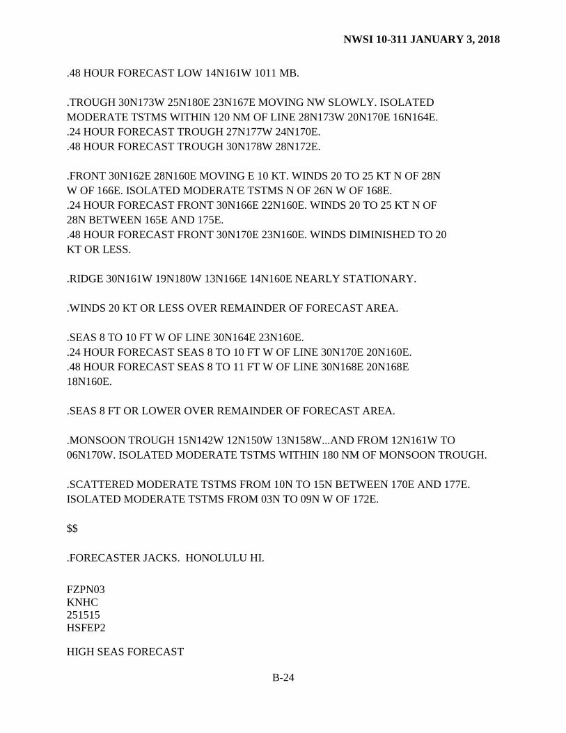
5.3.5 HSF Forecast Parameters a. Winds. Winds represent sustained conditions at 10 meters above the surface of the water. Forecasters should describe forecast wind speeds with either one representative value or, when significant differences are expected, with a small (i.e., 5 to 10 KT) range of values for the affected area. Forecasters may give these in terms of distances from the low pressure center, distances from the front or trough, or by a polygon based description using latitude / longitude points. Differences in the radial extent of forecast winds around a low pressure center are usually distinguished by quadrant or semicircle. Forecasters need not include wind direction. Forecasters should usually limit the description of winds to areas in which they are greater than 20 KT. They may use a statement such as WINDS 20 KT OR LESS for conditions elsewhere in the forecast area. These thresholds may be adjusted to account for climatology. The disclaimer for the remainder of the forecast reads: REMAINDER AREA WINDS 20 KT OR LESS. SEAS LESS THAN 8 FT. For the High Seas forecasts, forecasters should NOT use the term “WIND” in the singular. They should use “WINDS” instead. b. Seas.
1. Describe significant wave heights with either one representative value or, when a large variation is expected, with an appropriate range of values for the affected area. Forecasters may give these in terms of distances from the low pressure center, distances from the front or trough, or by latitude / longitude. Differences in the radial extent of forecast seas around a low pressure center are usually distinguished by quadrant or semicircle.
2. Forecasters should usually limit the description of seas to areas in which they are 8 feet or
higher. They may use a statement such as SEAS LESS THAN 8 FT for conditions elsewhere in the forecast area. These thresholds may be adjusted to account for climatology.
3. HSF products will include a statement that explains the seas forecast as the significant wave
height which is the average of the highest 1/3 of the waves, and that individual waves may be more than twice as high. This statement may be included after the forecast heading and before the safety message (ex., SECURITE, PAN PAN).
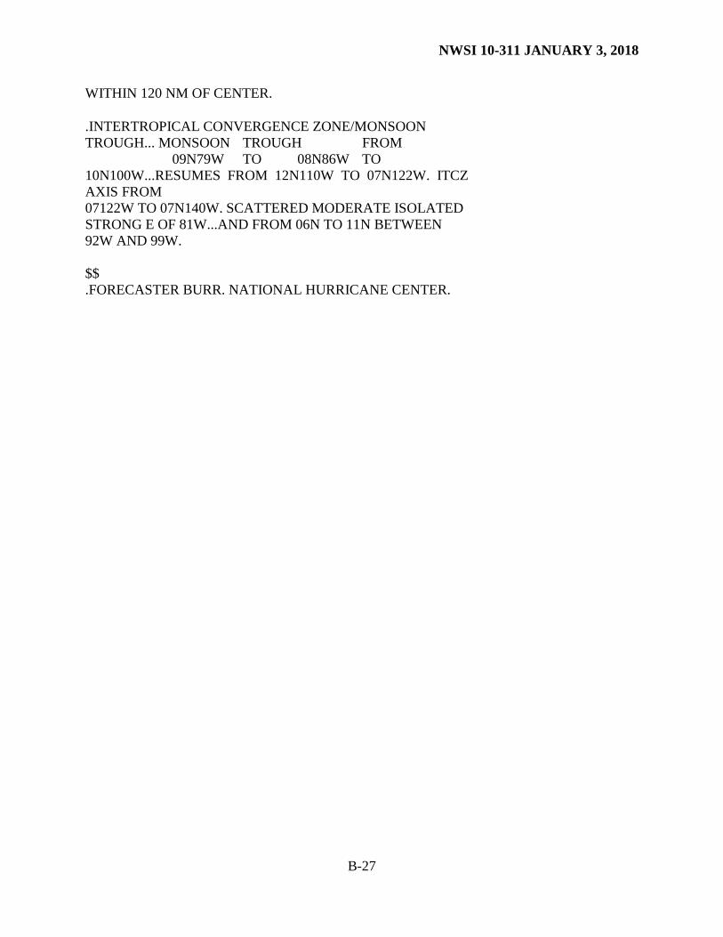
c. Significant Weather / Visibility. Forecasters should include significant weather such as obstructions to visibility, thunderstorms, squalls, and ship icing. For those HSFs covering areas south of 30°N, forecasters may include thunderstorm information associated with the Inter-tropical Convergence Zone (ITCZ) and monsoon trough. Forecasters should emphasize visibilities expected to be less than 1 NM in the HSF. They should mention obstructions to vision below 1 NM if the condition is widespread enough to affect a
NWSI 10-311 JANUARY 3, 2018
24
significant portion of the forecast area. They may include specific distances. However, do not include cloud conditions in the HSF. d. Icing. When appropriate, include a headline for HEAVY FREEZING SPRAY in the HSF. An ice accretion rate of 2 cm / hour or greater is considered heavy freezing spray. See definitions in NWSI 10-303.
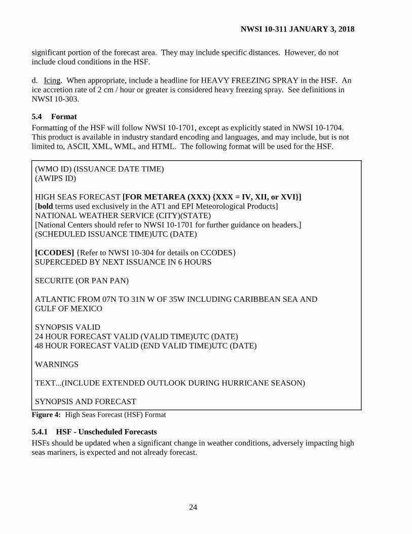
5.4 Format Formatting of the HSF will follow NWSI 10-1701, except as explicitly stated in NWSI 10-1704. This product is available in industry standard encoding and languages, and may include, but is not limited to, ASCII, XML, WML, and HTML. The following format will be used for the HSF.
(WMO ID) (ISSUANCE DATE TIME) (AWIPS ID) HIGH SEAS FORECAST [FOR METAREA (XXX) {XXX = IV, XII, or XVI}] [bold terms used exclusively in the AT1 and EPI Meteorological Products] NATIONAL WEATHER SERVICE (CITY)(STATE) [National Centers should refer to NWSI 10-1701 for further guidance on headers.] (SCHEDULED ISSUANCE TIME)UTC (DATE) [CCODES] {Refer to NWSI 10-304 for details on CCODES} SUPERCEDED BY NEXT ISSUANCE IN 6 HOURS SECURITE (OR PAN PAN) ATLANTIC FROM 07N TO 31N W OF 35W INCLUDING CARIBBEAN SEA AND GULF OF MEXICO SYNOPSIS VALID 24 HOUR FORECAST VALID (VALID TIME)UTC (DATE) 48 HOUR FORECAST VALID (END VALID TIME)UTC (DATE) WARNINGS TEXT...(INCLUDE EXTENDED OUTLOOK DURING HURRICANE SEASON) SYNOPSIS AND FORECAST
Figure 4: High Seas Forecast (HSF) Format
5.4.1 HSF - Unscheduled Forecasts HSFs should be updated when a significant change in weather conditions, adversely impacting high seas mariners, is expected and not already forecast.
NWSI 10-311 JANUARY 3, 2018
25
5.5 SafetyNET Inmarsat-C SafetyNET is an internationally-adopted, automated satellite system for disseminating weather forecasts and warnings, marine navigational warnings and other safety related information to all types of vessels. Along with NAVTEX, it is part of the Global Maritime Distress and Safety System (GMDSS).
5.5.1 “C CODES” To control product dissemination of high seas forecasts broadcast via SafetyNET, a system of “C codes” is used. It is vital this format be followed explicitly. “C codes” take the following form and are located as in the following example: FZNT01 KWBC 111613 HSFAT1 HIGH SEAS FORECAST FOR METAREA IV NWS OCEAN PREDICTION CENTER WASHINGTON DC 1630 UTC FRI JUL 11 2008 CCODE/C1:C2:C3:C4:C5/SAT/NWS/CCODE SUPERSEDED BY NEXT ISSUANCE IN 6 HOURS (TEXT) For routine HSFs: HSFAT1 - CCODE/1:31:04:01:00/AOW/NWS/CCODE HSFEPI - CCODE/1:31:12:01:00/AOW+POR/NWS/CCODE For HSFs containing extra-tropical hurricane force warnings: HSFAT1 - CCODE/2:31:04:01:00/AOW/NWS/CCODE HSFEPI - CCODE/2:31:12:01:00/AOW+POR/NWS/CCODE For HSFs containing hurricane/typhoon warnings within 48 hours of the synoptic time: HSFAT1 - CCODE/2:31:04:11:00/AOW+AOE/NWS/CCODE HSFEPI - CCODE/2:31:12:11:00/AOW+POR+AOE/NWS/CCODE HSFs: HSFSP, HSFNP, HSFEP1, HSFEP2, and HSFAT2 are not broadcast individually over SafetyNET and will not contain CCODES, or the notation of METAREA.
5.5.2 Issuance Times HSFs issued by OPC, are broadcast via SafetyNET as shown below: METAREA Product ID Satellite(s) Broadcast Time (UTC)* IV (Atlantic) HSFAT1 AOW 0430, 1030, 1630, 2230 XII (Pacific) HSFEPI AOW+POR 0545, 1145, 1745, 2345
NWSI 10-311 JANUARY 3, 2018
26
* For proper operation of the SafetyNET “HIGHSEAS” transmission and monitoring system within the NWS Telecommunications Gateway (TG), these products should be issued no earlier than 1 hour before the scheduled broadcast time or later than the scheduled broadcast time.
5.6 Graphic Products Appendix A lists graphic high seas products. Forecasters should ensure these products are consistent with information contained in neighboring offices’ compatible text and graphic products. These products are available in industry standard encoding and languages, and may include, but not limited to, “.tif,” “.gif,” and “.jpeg”.
5.7 Updates, Amendments and Corrections HSFs will be updated or corrected when the forecaster believes the current forecast is not representative, or when, in the forecaster’s judgment, significant format or content errors are detected. If necessary, append either “...UPDATED” or “...CORRECTED” to the product header when disseminating a correction or amendment. Amendment codes (AAx) and update/correction codes (CCx) will be followed using NWSI 10-1701, section 4.1.
NWSI 10-311 JANUARY 3, 2018
A-1
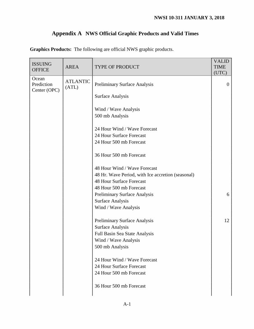
Appendix A NWS Official Graphic Products and Valid Times
Graphics Products: The following are official NWS graphic products.
* Tropical Cyclone Danger Area chart is prepared from May 15 to November 30. ** High Wind and Associated Seas chart is prepared from December 1 to May 14.
NWSI 10-311 JANUARY 3, 2018
B-1
Appendix B Examples of NWS Offshore, MIM, NAVTEX, and High Seas Forecasts
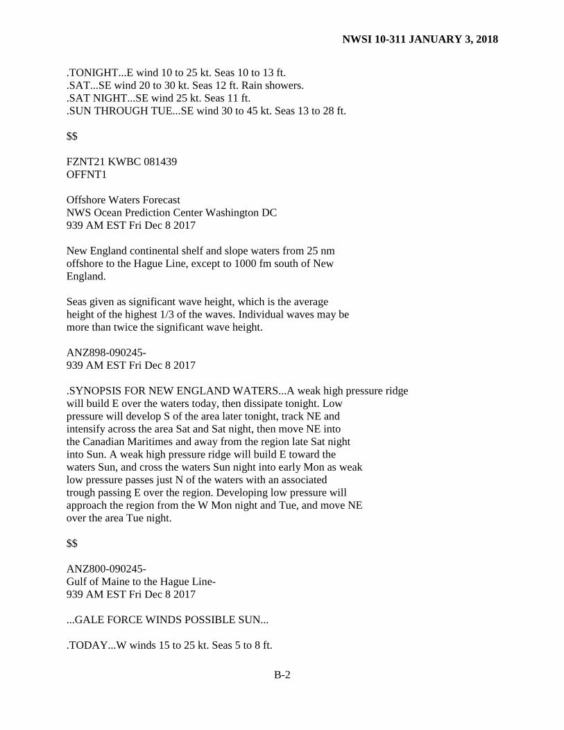
Offshore Waters Forecast (OFF) FZAK61 PAFC 081233 OFFAER Offshore Waters Forecast National Weather Service Anchorage AK 333 AM AKST Fri Dec 8 2017 Offshore waters forecast for the Gulf of Alaska West of 144W Wind forecasts reflect the predominant speed and direction expected. Sea forecasts represent an average of the highest one-third of the combined wind wave and swell height. PKZ399-090200- 333 AM AKST Fri Dec 8 2017 .SYNOPSIS FOR THE WESTERN GULF OF ALASKA... A 980 mb low at 47N 158W moves to 49N 155W at 982 mb Fri night. The low then moves to 53N 160W at 988 mb Sat night. A strong front remains nearly stationary in the eastern Gulf through Sat night. $$ PKZ351-090200- Gulf of Alaska Offshore North of 57N and West of 144W- 333 AM AKST Fri Dec 8 2017 .TODAY...SW wind 10 kt becoming E in the afternoon. Seas 12 ft. .TONIGHT...E wind 10 to 20 kt. Seas 11 ft. .SAT...E wind 15 to 30 kt. Seas 11 ft. Rain. .SAT NIGHT...SE wind 25 kt. Seas 12 ft. .SUN THROUGH MON...S wind 30 to 45 kt. Seas 14 to 29 ft. .TUE...SE wind 20 to 30 kt. Seas 14 to 19 ft. $$ PKZ352-090200- Gulf of Alaska Offshore South of 57N North of 55N and West of 144W- 333 AM AKST Fri Dec 8 2017 .TODAY...SE wind 10 to 20 kt. Seas 10 to 13 ft.
NWSI 10-311 JANUARY 3, 2018
B-2
.TONIGHT...E wind 10 to 25 kt. Seas 10 to 13 ft.
.SAT...SE wind 20 to 30 kt. Seas 12 ft. Rain showers.
.SAT NIGHT...SE wind 25 kt. Seas 11 ft.
.SUN THROUGH TUE...SE wind 30 to 45 kt. Seas 13 to 28 ft. $$ FZNT21 KWBC 081439 OFFNT1 Offshore Waters Forecast NWS Ocean Prediction Center Washington DC 939 AM EST Fri Dec 8 2017 New England continental shelf and slope waters from 25 nm offshore to the Hague Line, except to 1000 fm south of New England. Seas given as significant wave height, which is the average height of the highest 1/3 of the waves. Individual waves may be more than twice the significant wave height. ANZ898-090245- 939 AM EST Fri Dec 8 2017 .SYNOPSIS FOR NEW ENGLAND WATERS...A weak high pressure ridge will build E over the waters today, then dissipate tonight. Low pressure will develop S of the area later tonight, track NE and intensify across the area Sat and Sat night, then move NE into the Canadian Maritimes and away from the region late Sat night into Sun. A weak high pressure ridge will build E toward the waters Sun, and cross the waters Sun night into early Mon as weak low pressure passes just N of the waters with an associated trough passing E over the region. Developing low pressure will approach the region from the W Mon night and Tue, and move NE over the area Tue night. $$ ANZ800-090245- Gulf of Maine to the Hague Line- 939 AM EST Fri Dec 8 2017 ...GALE FORCE WINDS POSSIBLE SUN... .TODAY...W winds 15 to 25 kt. Seas 5 to 8 ft.
NWSI 10-311 JANUARY 3, 2018
B-3
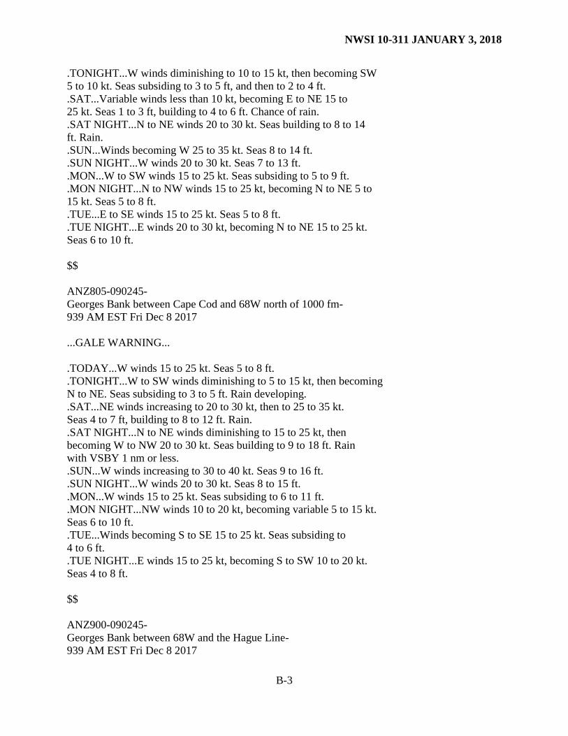
.TONIGHT...W winds diminishing to 10 to 15 kt, then becoming SW 5 to 10 kt. Seas subsiding to 3 to 5 ft, and then to 2 to 4 ft. .SAT...Variable winds less than 10 kt, becoming E to NE 15 to 25 kt. Seas 1 to 3 ft, building to 4 to 6 ft. Chance of rain. .SAT NIGHT...N to NE winds 20 to 30 kt. Seas building to 8 to 14 ft. Rain. .SUN...Winds becoming W 25 to 35 kt. Seas 8 to 14 ft. .SUN NIGHT...W winds 20 to 30 kt. Seas 7 to 13 ft. .MON...W to SW winds 15 to 25 kt. Seas subsiding to 5 to 9 ft. .MON NIGHT...N to NW winds 15 to 25 kt, becoming N to NE 5 to 15 kt. Seas 5 to 8 ft. .TUE...E to SE winds 15 to 25 kt. Seas 5 to 8 ft. .TUE NIGHT...E winds 20 to 30 kt, becoming N to NE 15 to 25 kt. Seas 6 to 10 ft. $$ ANZ805-090245- Georges Bank between Cape Cod and 68W north of 1000 fm- 939 AM EST Fri Dec 8 2017 ...GALE WARNING... .TODAY...W winds 15 to 25 kt. Seas 5 to 8 ft. .TONIGHT...W to SW winds diminishing to 5 to 15 kt, then becoming N to NE. Seas subsiding to 3 to 5 ft. Rain developing. .SAT...NE winds increasing to 20 to 30 kt, then to 25 to 35 kt. Seas 4 to 7 ft, building to 8 to 12 ft. Rain. .SAT NIGHT...N to NE winds diminishing to 15 to 25 kt, then becoming W to NW 20 to 30 kt. Seas building to 9 to 18 ft. Rain with VSBY 1 nm or less. .SUN...W winds increasing to 30 to 40 kt. Seas 9 to 16 ft. .SUN NIGHT...W winds 20 to 30 kt. Seas 8 to 15 ft. .MON...W winds 15 to 25 kt. Seas subsiding to 6 to 11 ft. .MON NIGHT...NW winds 10 to 20 kt, becoming variable 5 to 15 kt. Seas 6 to 10 ft. .TUE...Winds becoming S to SE 15 to 25 kt. Seas subsiding to 4 to 6 ft. .TUE NIGHT...E winds 15 to 25 kt, becoming S to SW 10 to 20 kt. Seas 4 to 8 ft. $$ ANZ900-090245- Georges Bank between 68W and the Hague Line- 939 AM EST Fri Dec 8 2017
NWSI 10-311 JANUARY 3, 2018
B-4
...GALE WARNING... .TODAY...W to SW winds 15 to 25 kt. Seas 6 to 10 ft, subsiding to 5 to 7 ft. .TONIGHT...W to SW winds diminishing to 5 to 15 kt, then becoming N to NE. Seas subsiding to 3 to 5 ft. Rain developing. .SAT...NE winds increasing to 20 to 30 kt, then to 25 to 35 kt. Seas 4 to 7 ft, building to 8 to 12 ft. Rain. .SAT NIGHT...Winds becoming S to SW 30 to 40 kt early, then becoming W to SW 20 to 30 kt. Seas building to 11 to 21 ft. Rain. VSBY 1 nm or less. .SUN...W winds 25 to 35 kt. Seas becoming 12 to 16 ft. .SUN NIGHT...W winds 20 to 30 kt. Seas 9 to 15 ft. .MON...W winds 15 to 25 kt. Seas subsiding to 8 to 12 ft. .MON NIGHT...W to NW winds 10 to 20 kt, becoming variable 5 to 15 kt. Seas 6 to 10 ft. .TUE...Winds becoming S to SE 15 to 25 kt. Seas 5 to 7 ft. .TUE NIGHT...S winds 20 to 30 kt. Seas building to 7 to 11 ft. $$ ANZ810-090245- South of New England between the Great South Channel and Montauk Point to 1000 fm- 939 AM EST Fri Dec 8 2017 ...GALE FORCE WINDS POSSIBLE SUN... .TODAY...W winds 10 to 20 kt. Seas 4 to 8 ft. Rain developing. .TONIGHT...W to NW winds diminishing to 5 to 10 kt, then becoming N to NE 5 to 15 kt. Seas subsiding to 2 to 4 ft. Rain. .SAT...NE winds increasing to 20 to 30 kt. Seas 3 to 6 ft, building to 8 to 12 ft. Rain. .SAT NIGHT...N winds 15 to 25 kt, becoming W to NW 20 to 30 kt. Seas becoming 8 to 16 ft. Rain with VSBY 1 nm or less. .SUN...W winds increasing to 30 to 40 kt. Seas 10 to 15 ft. .SUN NIGHT...W winds diminishing to 15 to 25 kt. Seas 8 to 14 ft. .MON...W winds 20 to 30 kt. Seas subsiding to 6 to 10 ft. .MON NIGHT...W to NW winds diminishing to 5 to 15 kt, then becoming variable. Seas subsiding to 4 to 7 ft. .TUE...S to SE winds 10 to 20 kt. Seas 4 to 5 ft. .TUE NIGHT...S to SW winds 5 to 15 kt, becoming N to NW 10 to 20 kt. Seas 4 to 7 ft.
NWSI 10-311 JANUARY 3, 2018
B-5
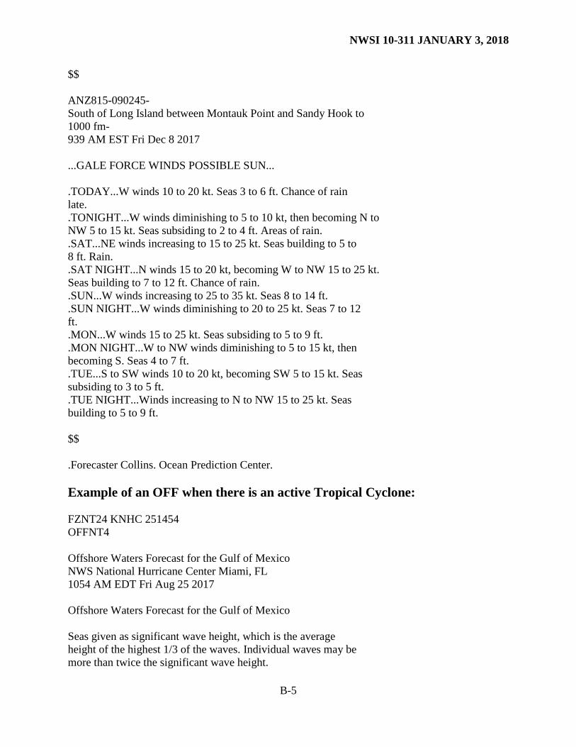
$$ ANZ815-090245- South of Long Island between Montauk Point and Sandy Hook to 1000 fm- 939 AM EST Fri Dec 8 2017 ...GALE FORCE WINDS POSSIBLE SUN... .TODAY...W winds 10 to 20 kt. Seas 3 to 6 ft. Chance of rain late. .TONIGHT...W winds diminishing to 5 to 10 kt, then becoming N to NW 5 to 15 kt. Seas subsiding to 2 to 4 ft. Areas of rain. .SAT...NE winds increasing to 15 to 25 kt. Seas building to 5 to 8 ft. Rain. .SAT NIGHT...N winds 15 to 20 kt, becoming W to NW 15 to 25 kt. Seas building to 7 to 12 ft. Chance of rain. .SUN...W winds increasing to 25 to 35 kt. Seas 8 to 14 ft. .SUN NIGHT...W winds diminishing to 20 to 25 kt. Seas 7 to 12 ft. .MON...W winds 15 to 25 kt. Seas subsiding to 5 to 9 ft. .MON NIGHT...W to NW winds diminishing to 5 to 15 kt, then becoming S. Seas 4 to 7 ft. .TUE...S to SW winds 10 to 20 kt, becoming SW 5 to 15 kt. Seas subsiding to 3 to 5 ft. .TUE NIGHT...Winds increasing to N to NW 15 to 25 kt. Seas building to 5 to 9 ft. $$ .Forecaster Collins. Ocean Prediction Center. Example of an OFF when there is an active Tropical Cyclone: FZNT24 KNHC 251454 OFFNT4 Offshore Waters Forecast for the Gulf of Mexico NWS National Hurricane Center Miami, FL 1054 AM EDT Fri Aug 25 2017 Offshore Waters Forecast for the Gulf of Mexico Seas given as significant wave height, which is the average height of the highest 1/3 of the waves. Individual waves may be more than twice the significant wave height.
NWSI 10-311 JANUARY 3, 2018
B-6
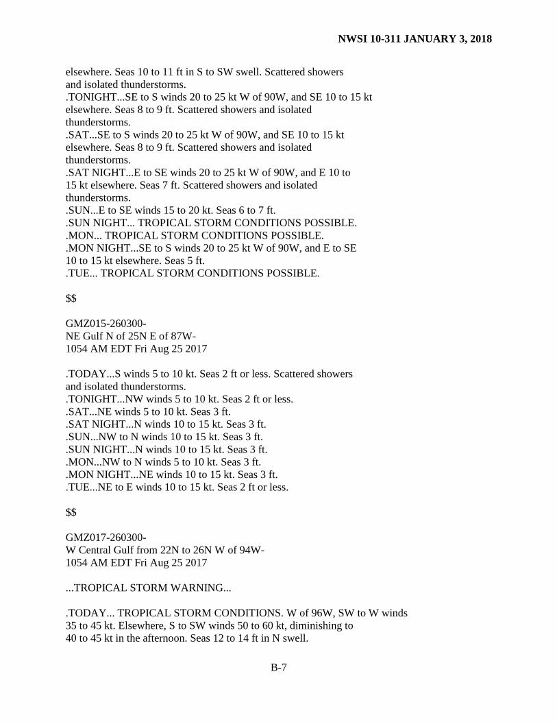
GMZ001-260300- Synopsis for the Gulf of Mexico 1054 AM EDT Fri Aug 25 2017 .SYNOPSIS...Hurricane Harvey is centered near 26.7N 96.0W at 25/1500 UTC, moving NW, or 315 degrees at 9 kt. Estimated minimum central pressure is 947 mb. Maximum sustained winds are 95 kt gusting to 115 kt. Harvey is forecast to reach near 27.6N 96.8W this evening, reaching a position inland near 28.4N 97.3W Saturday morning. Harvey is then likely to stall near or just inland of the middle Texas coast through the remainder of the weekend. $$ GMZ011-260300- NW Gulf including Stetson Bank- 1054 AM EDT Fri Aug 25 2017 ...HURRICANE WARNING... .TODAY... HURRICANE CONDITIONS. SE winds 65 to 85 kt. Seas 25 to 26 ft in SE to S swell. Scattered showers and isolated thunderstorms. VSBY 1 NM or less. .TONIGHT... TROPICAL STORM CONDITIONS EXPECTED. SE to S winds 50 to 60 kt, diminishing to 40 to 45 kt late. Seas 14 to 16 ft. Scattered showers and isolated thunderstorms. VSBY 1 NM or less. .SAT... TROPICAL STORM CONDITIONS EXPECTED. S winds 30 to 35 kt. Seas 12 to 13 ft in S swell. Scattered showers and isolated thunderstorms. .SAT NIGHT... TROPICAL STORM CONDITIONS POSSIBLE. SE winds 20 to 25 kt. Seas 8 to 9 ft. Scattered showers and isolated thunderstorms. .SUN... TROPICAL STORM CONDITIONS POSSIBLE. SE to S winds 20 to 25 kt. Seas 7 to 8 ft. .SUN NIGHT... HURRICANE CONDITIONS POSSIBLE. .MON... HURRICANE CONDITIONS POSSIBLE. .MON NIGHT... TROPICAL STORM CONDITIONS POSSIBLE. .TUE... TROPICAL STORM CONDITIONS POSSIBLE. $$ GMZ013-260300- N Central Gulf including Flower Garden Banks Marine Sanctuary- 1054 AM EDT Fri Aug 25 2017 .TODAY...SE to S winds 25 to 30 kt W of 90W, and SE 10 to 15 kt
NWSI 10-311 JANUARY 3, 2018
B-7
elsewhere. Seas 10 to 11 ft in S to SW swell. Scattered showers and isolated thunderstorms. .TONIGHT...SE to S winds 20 to 25 kt W of 90W, and SE 10 to 15 kt elsewhere. Seas 8 to 9 ft. Scattered showers and isolated thunderstorms. .SAT...SE to S winds 20 to 25 kt W of 90W, and SE 10 to 15 kt elsewhere. Seas 8 to 9 ft. Scattered showers and isolated thunderstorms. .SAT NIGHT...E to SE winds 20 to 25 kt W of 90W, and E 10 to 15 kt elsewhere. Seas 7 ft. Scattered showers and isolated thunderstorms. .SUN...E to SE winds 15 to 20 kt. Seas 6 to 7 ft. .SUN NIGHT... TROPICAL STORM CONDITIONS POSSIBLE. .MON... TROPICAL STORM CONDITIONS POSSIBLE. .MON NIGHT...SE to S winds 20 to 25 kt W of 90W, and E to SE 10 to 15 kt elsewhere. Seas 5 ft. .TUE... TROPICAL STORM CONDITIONS POSSIBLE. $$ GMZ015-260300- NE Gulf N of 25N E of 87W- 1054 AM EDT Fri Aug 25 2017 .TODAY...S winds 5 to 10 kt. Seas 2 ft or less. Scattered showers and isolated thunderstorms. .TONIGHT...NW winds 5 to 10 kt. Seas 2 ft or less. .SAT...NE winds 5 to 10 kt. Seas 3 ft. .SAT NIGHT...N winds 10 to 15 kt. Seas 3 ft. .SUN...NW to N winds 10 to 15 kt. Seas 3 ft. .SUN NIGHT...N winds 10 to 15 kt. Seas 3 ft. .MON...NW to N winds 5 to 10 kt. Seas 3 ft. .MON NIGHT...NE winds 10 to 15 kt. Seas 3 ft. .TUE...NE to E winds 10 to 15 kt. Seas 2 ft or less. $$ GMZ017-260300- W Central Gulf from 22N to 26N W of 94W- 1054 AM EDT Fri Aug 25 2017 ...TROPICAL STORM WARNING... .TODAY... TROPICAL STORM CONDITIONS. W of 96W, SW to W winds 35 to 45 kt. Elsewhere, S to SW winds 50 to 60 kt, diminishing to 40 to 45 kt in the afternoon. Seas 12 to 14 ft in N swell.
NWSI 10-311 JANUARY 3, 2018
B-8
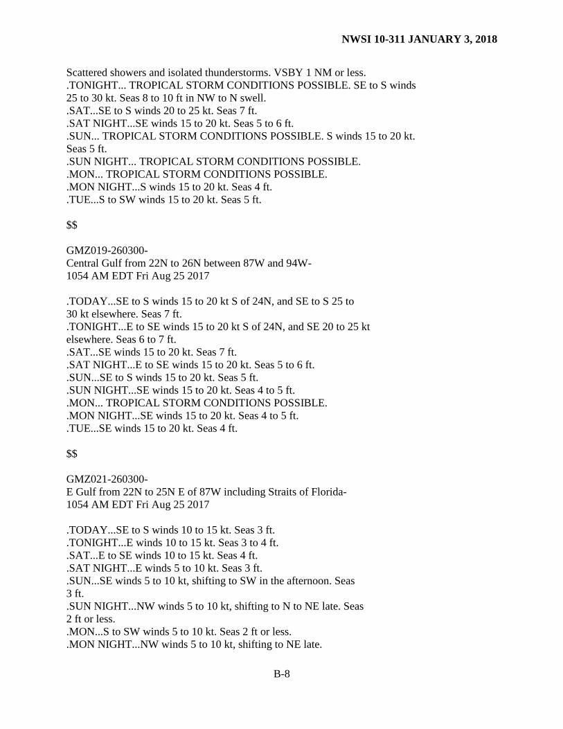
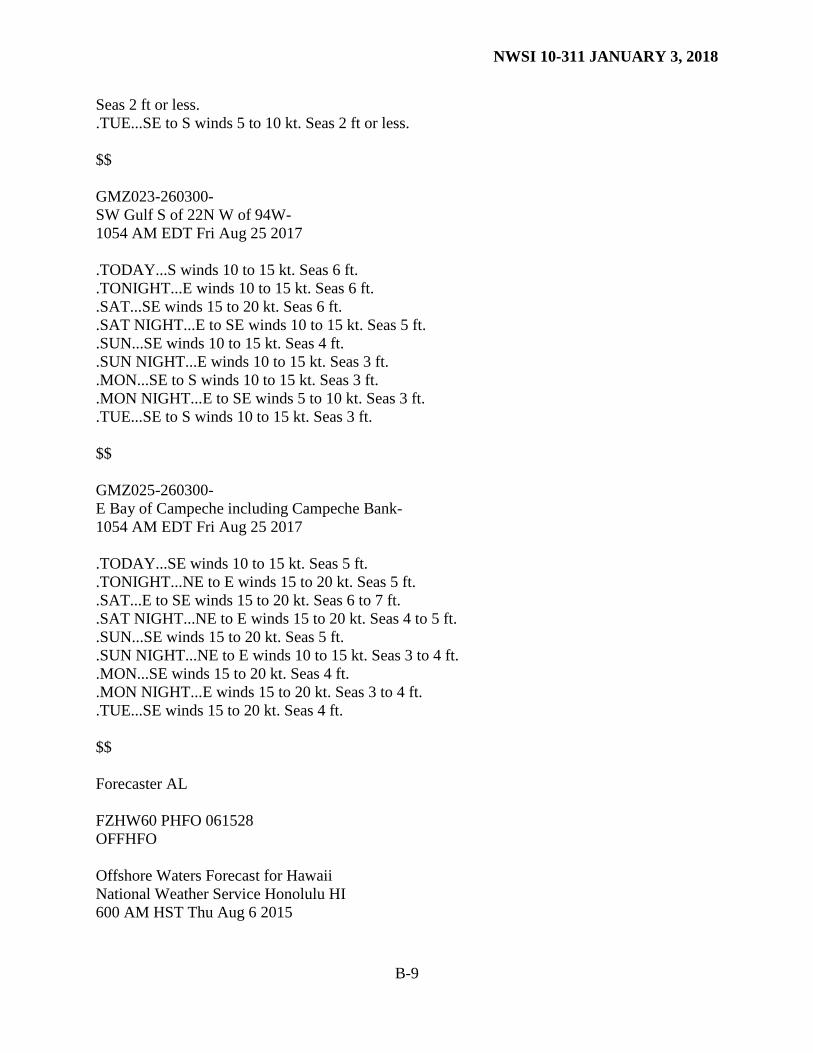
Scattered showers and isolated thunderstorms. VSBY 1 NM or less. .TONIGHT... TROPICAL STORM CONDITIONS POSSIBLE. SE to S winds 25 to 30 kt. Seas 8 to 10 ft in NW to N swell. .SAT...SE to S winds 20 to 25 kt. Seas 7 ft. .SAT NIGHT...SE winds 15 to 20 kt. Seas 5 to 6 ft. .SUN... TROPICAL STORM CONDITIONS POSSIBLE. S winds 15 to 20 kt. Seas 5 ft. .SUN NIGHT... TROPICAL STORM CONDITIONS POSSIBLE. .MON... TROPICAL STORM CONDITIONS POSSIBLE. .MON NIGHT...S winds 15 to 20 kt. Seas 4 ft. .TUE...S to SW winds 15 to 20 kt. Seas 5 ft. $$ GMZ019-260300- Central Gulf from 22N to 26N between 87W and 94W- 1054 AM EDT Fri Aug 25 2017 .TODAY...SE to S winds 15 to 20 kt S of 24N, and SE to S 25 to 30 kt elsewhere. Seas 7 ft. .TONIGHT...E to SE winds 15 to 20 kt S of 24N, and SE 20 to 25 kt elsewhere. Seas 6 to 7 ft. .SAT...SE winds 15 to 20 kt. Seas 7 ft. .SAT NIGHT...E to SE winds 15 to 20 kt. Seas 5 to 6 ft. .SUN...SE to S winds 15 to 20 kt. Seas 5 ft. .SUN NIGHT...SE winds 15 to 20 kt. Seas 4 to 5 ft. .MON... TROPICAL STORM CONDITIONS POSSIBLE. .MON NIGHT...SE winds 15 to 20 kt. Seas 4 to 5 ft. .TUE...SE winds 15 to 20 kt. Seas 4 ft. $$ GMZ021-260300- E Gulf from 22N to 25N E of 87W including Straits of Florida- 1054 AM EDT Fri Aug 25 2017 .TODAY...SE to S winds 10 to 15 kt. Seas 3 ft. .TONIGHT...E winds 10 to 15 kt. Seas 3 to 4 ft. .SAT...E to SE winds 10 to 15 kt. Seas 4 ft. .SAT NIGHT...E winds 5 to 10 kt. Seas 3 ft. .SUN...SE winds 5 to 10 kt, shifting to SW in the afternoon. Seas 3 ft. .SUN NIGHT...NW winds 5 to 10 kt, shifting to N to NE late. Seas 2 ft or less. .MON...S to SW winds 5 to 10 kt. Seas 2 ft or less. .MON NIGHT...NW winds 5 to 10 kt, shifting to NE late.
NWSI 10-311 JANUARY 3, 2018
B-9
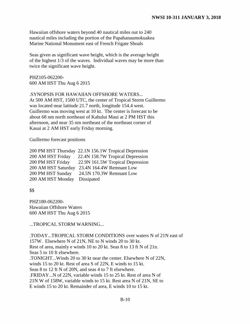
Seas 2 ft or less. .TUE...SE to S winds 5 to 10 kt. Seas 2 ft or less. $$ GMZ023-260300- SW Gulf S of 22N W of 94W- 1054 AM EDT Fri Aug 25 2017 .TODAY...S winds 10 to 15 kt. Seas 6 ft. .TONIGHT...E winds 10 to 15 kt. Seas 6 ft. .SAT...SE winds 15 to 20 kt. Seas 6 ft. .SAT NIGHT...E to SE winds 10 to 15 kt. Seas 5 ft. .SUN...SE winds 10 to 15 kt. Seas 4 ft. .SUN NIGHT...E winds 10 to 15 kt. Seas 3 ft. .MON...SE to S winds 10 to 15 kt. Seas 3 ft. .MON NIGHT...E to SE winds 5 to 10 kt. Seas 3 ft. .TUE...SE to S winds 10 to 15 kt. Seas 3 ft. $$ GMZ025-260300- E Bay of Campeche including Campeche Bank- 1054 AM EDT Fri Aug 25 2017 .TODAY...SE winds 10 to 15 kt. Seas 5 ft. .TONIGHT...NE to E winds 15 to 20 kt. Seas 5 ft. .SAT...E to SE winds 15 to 20 kt. Seas 6 to 7 ft. .SAT NIGHT...NE to E winds 15 to 20 kt. Seas 4 to 5 ft. .SUN...SE winds 15 to 20 kt. Seas 5 ft. .SUN NIGHT...NE to E winds 10 to 15 kt. Seas 3 to 4 ft. .MON...SE winds 15 to 20 kt. Seas 4 ft. .MON NIGHT...E winds 15 to 20 kt. Seas 3 to 4 ft. .TUE...SE winds 15 to 20 kt. Seas 4 ft. $$ Forecaster AL FZHW60 PHFO 061528 OFFHFO Offshore Waters Forecast for Hawaii National Weather Service Honolulu HI 600 AM HST Thu Aug 6 2015
NWSI 10-311 JANUARY 3, 2018
B-10
Hawaiian offshore waters beyond 40 nautical miles out to 240 nautical miles including the portion of the Papahanaumokuakea Marine National Monument east of French Frigate Shoals Seas given as significant wave height, which is the average height of the highest 1/3 of the waves. Individual waves may be more than twice the significant wave height. PHZ105-062200- 600 AM HST Thu Aug 6 2015 .SYNOPSIS FOR HAWAIIAN OFFSHORE WATERS... At 500 AM HST, 1500 UTC, the center of Tropical Storm Guillermo was located near latitude 21.7 north, longitude 154.4 west. Guillermo was moving west at 10 kt. The center is forecast to be about 68 nm north northeast of Kahului Maui at 2 PM HST this afternoon, and near 35 nm northeast of the northeast corner of Kauai at 2 AM HST early Friday morning. Guillermo forecast positions 200 PM HST Thursday 22.1N 156.1W Tropical Depression 200 AM HST Friday 22.4N 158.7W Tropical Depression 200 PM HST Friday 22.9N 161.5W Tropical Depression 200 AM HST Saturday 23.4N 164.4W Remnant Low 200 PM HST Sunday 24.5N 170.3W Remnant Low 200 AM HST Monday Dissipated $$ PHZ180-062200- Hawaiian Offshore Waters 600 AM HST Thu Aug 6 2015 ...TROPICAL STORM WARNING... .TODAY...TROPICAL STORM CONDITIONS over waters N of 21N east of 157W. Elsewhere N of 21N, NE to N winds 20 to 30 kt. Rest of area, mainly e winds 10 to 20 kt. Seas 8 to 13 ft N of 21n. Seas 5 to 10 ft elsewhere. .TONIGHT...Winds 20 to 30 kt near the center. Elsewhere N of 22N, winds 15 to 20 kt. Rest of area S of 22N, E winds to 15 kt. Seas 8 to 12 ft N of 20N, and seas 4 to 7 ft elsewhere. .FRIDAY...N of 22N, variable winds 15 to 25 kt. Rest of area N of 21N W of 158W, variable winds to 15 kt. Rest area N of 21N, SE to E winds 15 to 20 kt. Remainder of area, E winds 10 to 15 kt.
NWSI 10-311 JANUARY 3, 2018
B-11
Seas N of 23N W of 156W, 8 TO 12 ft. Rest of area, seas 5 to 8 ft. .FRIDAY NIGHT...Area N of 23N W of 160W, SE winds 10 to 20 kt. Rest of area N of 20N, E winds 10 to 15 kt. Remainder of area, E winds 15 to 20 kt. Seas 5 to 8 ft. .SATURDAY AND SUNDAY...N of 20N, E winds 10 to 15 kt. Rest of Area, E winds 15 to 20 kt. Seas 5 to 8 ft. .MONDAY...NE to E winds 10 to 15 kt. Seas 5 to 7 ft. $$
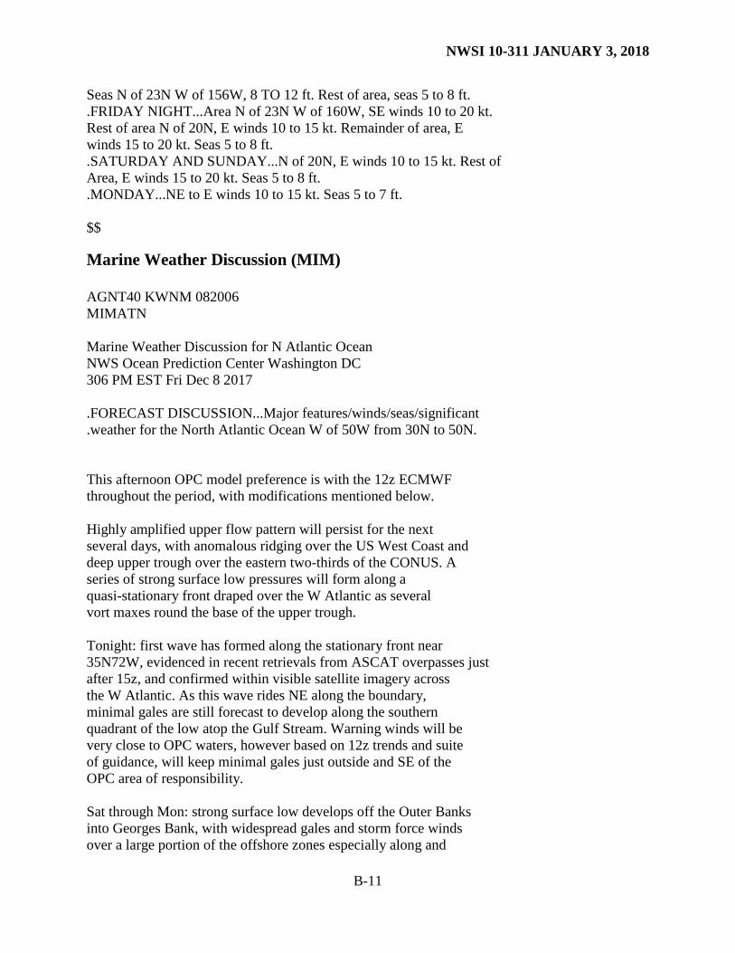
Marine Weather Discussion (MIM) AGNT40 KWNM 082006 MIMATN Marine Weather Discussion for N Atlantic Ocean NWS Ocean Prediction Center Washington DC 306 PM EST Fri Dec 8 2017 .FORECAST DISCUSSION...Major features/winds/seas/significant .weather for the North Atlantic Ocean W of 50W from 30N to 50N. This afternoon OPC model preference is with the 12z ECMWF throughout the period, with modifications mentioned below. Highly amplified upper flow pattern will persist for the next several days, with anomalous ridging over the US West Coast and deep upper trough over the eastern two-thirds of the CONUS. A series of strong surface low pressures will form along a quasi-stationary front draped over the W Atlantic as several vort maxes round the base of the upper trough. Tonight: first wave has formed along the stationary front near 35N72W, evidenced in recent retrievals from ASCAT overpasses just after 15z, and confirmed within visible satellite imagery across the W Atlantic. As this wave rides NE along the boundary, minimal gales are still forecast to develop along the southern quadrant of the low atop the Gulf Stream. Warning winds will be very close to OPC waters, however based on 12z trends and suite of guidance, will keep minimal gales just outside and SE of the OPC area of responsibility. Sat through Mon: strong surface low develops off the Outer Banks into Georges Bank, with widespread gales and storm force winds over a large portion of the offshore zones especially along and
NWSI 10-311 JANUARY 3, 2018
B-12
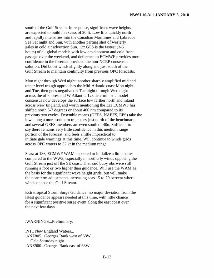
south of the Gulf Stream. In response, significant wave heights are expected to build in excess of 20 ft. Low lifts quickly north and rapidly intensifies into the Canadian Maritimes and Labrador Sea Sat night and Sun, with another parting shot of westerly gales in cold air advection Sun. 12z GFS is the fastest (3-6 hours) of all global models with low development and cold front passage over the weekend, and deference to ECMWF provides more confidence in the forecast provided the non-NCEP consensus solution. Did boost winds slightly along and just south of the Gulf Stream to maintain continuity from previous OPC forecasts. Mon night through Wed night: another sharply amplified mid and upper level trough approaches the Mid-Atlantic coast Mon night and Tue, then goes negative tilt Tue night through Wed night across the offshores and W Atlantic. 12z deterministic model consensus now develops the surface low farther north and inland across New England, and worth mentioning the 12z ECMWF has shifted north 5-7 degrees or about 400 nm compared to its previous two cycles. Ensemble means (GEFS, NAEFS, EPS) take the low along a more southern trajectory just north of the benchmark, and several GEFS members are even south of 40n. Suffice it to say there remains very little confidence in this medium range portion of the forecast, and feels a little impractical to initiate gale warnings at this time. Will continue to winds grids across OPC waters to 32 kt in the medium range. Seas: at 18z, ECMWF WAM appeared to initialize a little better compared to the WW3, especially in northerly winds opposing the Gulf Stream just off the SE coast. That said buoy obs were still running a foot or two higher than guidance. Will use the WAM as the basis for the significant wave height grids, but will make the near term adjustments increasing seas 15 to 20 percent where winds oppose the Gulf Stream. Extratropical Storm Surge Guidance: no major deviation from the latest guidance appears needed at this time, with little chance for a significant positive surge event along the east coast over the next few days. .WARNINGS...Preliminary. .NT1 New England Waters... .ANZ805...Georges Bank west of 68W... Gale Saturday night. .ANZ900...Georges Bank east of 68W...
NWSI 10-311 JANUARY 3, 2018
B-13
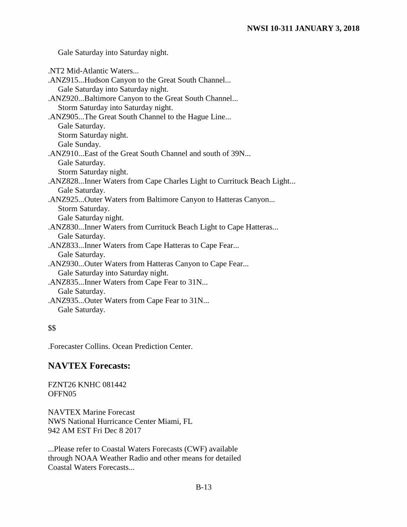
Gale Saturday into Saturday night. .NT2 Mid-Atlantic Waters... .ANZ915...Hudson Canyon to the Great South Channel... Gale Saturday into Saturday night. .ANZ920...Baltimore Canyon to the Great South Channel... Storm Saturday into Saturday night. .ANZ905...The Great South Channel to the Hague Line... Gale Saturday. Storm Saturday night. Gale Sunday. .ANZ910...East of the Great South Channel and south of 39N... Gale Saturday. Storm Saturday night. .ANZ828...Inner Waters from Cape Charles Light to Currituck Beach Light... Gale Saturday. .ANZ925...Outer Waters from Baltimore Canyon to Hatteras Canyon... Storm Saturday. Gale Saturday night. .ANZ830...Inner Waters from Currituck Beach Light to Cape Hatteras... Gale Saturday. .ANZ833...Inner Waters from Cape Hatteras to Cape Fear... Gale Saturday. .ANZ930...Outer Waters from Hatteras Canyon to Cape Fear... Gale Saturday into Saturday night. .ANZ835...Inner Waters from Cape Fear to 31N... Gale Saturday. .ANZ935...Outer Waters from Cape Fear to 31N... Gale Saturday. $$ .Forecaster Collins. Ocean Prediction Center. NAVTEX Forecasts: FZNT26 KNHC 081442 OFFN05 NAVTEX Marine Forecast NWS National Hurricance Center Miami, FL 942 AM EST Fri Dec 8 2017 ...Please refer to Coastal Waters Forecasts (CWF) available through NOAA Weather Radio and other means for detailed Coastal Waters Forecasts...
NWSI 10-311 JANUARY 3, 2018
B-14
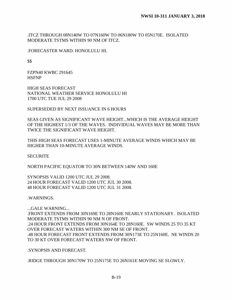
.SYNOPSIS...Moderate to fresh trade winds will affect the waters through the weekend, diminishing early next week as the pressure gradient weakens. Large northerly swell will dominate area seas before beginning to subside Sat night. San Juan Atlantic Waters .TODAY...E winds 15 to 20 kt. Seas 9 to 10 ft in N to NE swell. Isolated showers. .TONIGHT...E winds 15 to 20 kt. Seas 9 to 10 ft in N to NE swell. Isolated showers. .SAT AND SAT NIGHT...E winds 15 to 20 kt. Seas 7 to 10 ft in NE swell. Isolated showers. .SUN THROUGH MON...NE to E winds 10 to 15 kt. Seas 5 to 7 ft. .TUE...S winds 5 to 10 kt. Seas 5 to 6 ft in N swell. San Juan Caribbean Waters .TODAY...E winds 20 kt. Seas 7 to 9 ft in NE to E swell. Isolated showers. .TONIGHT...E winds 20 kt. Seas 7 to 9 ft in NE to E swell. Isolated showers. .SAT AND SAT NIGHT...NE to E winds 15 to 20 kt. Seas 6 to 9 ft. Isolated showers. .SUN THROUGH MON...NE to E winds 10 to 15 kt. Seas 4 to 6 ft. .TUE...E to SE winds 5 to 10 kt. Seas 3 ft. $$ High Seas Forecasts: FZPN02 KWBC 291700 HSFEPI HIGH SEAS FORECAST FOR METAREA XII NWS OCEAN PREDICTION CENTER WASHINGTON DC 1745 UTC TUE JUL 29 2008 CCODE/2:31:12:01:00/AOW+POR/NWS/CCODE SUPERSEDED BY NEXT ISSUANCE IN 6 HOURS SEAS GIVEN AS SIGNIFICANT WAVE HEIGHT...WHICH IS THE AVERAGE HEIGHT OF THE HIGHEST 1/3 OF THE WAVES. INDIVIDUAL WAVES MAY BE MORE THAN TWICE THE SIGNIFICANT WAVE HEIGHT.
NWSI 10-311 JANUARY 3, 2018
B-15
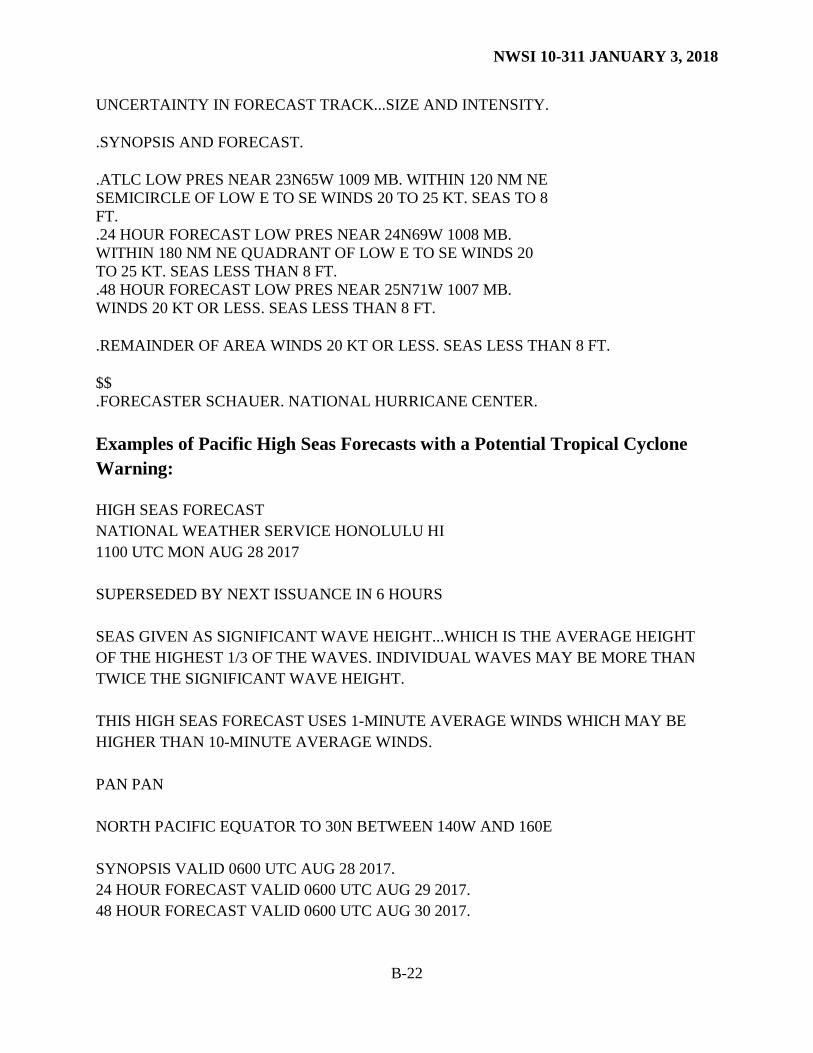
PAN PAN PACIFIC N OF 30N AND S OF 67N E OF A LINE FROM BERING STRAIT TO 50N 160E SYNOPSIS VALID 1200 UTC JUL 29. 24 HOUR FORECAST VALID 1200 UTC JUL 30. 48 HOUR FORECAST VALID 1200 UTC JUL 31. .WARNINGS. ...HURRICANE FORCE WIND WARNING... .LOW 57N147W 980 MB MOVING E 15 KT...WITH A FRONT FROM 59N146W TO 58N138W TO 49N130W TO 43N132W TO 40N134W. WITHIN 240 NM S AND SW QUADRANTS...WINDS 45 TO 65 KT. SEAS 18 TO 32 FT. ELSEWHERE WITHIN 480 NM W AND 900 NM S QUADRANTS...WINDS 30 TO 45 KT. SEAS 14 TO 26 FT. WITHIN 120 NM E OF FRONT BETWEEN 47N AND 55N...WINDS 35 TO 50 KT. SEAS 14 TO 23 FT. ELSEWHERE WITHIN 180 NM N AND E OF FRONT...WINDS 25 TO 40 KT. SEAS 10 TO 18 FT. ALSO N OF A LINE FROM 53N163W TO 39N140W TO 40N130W TO 47N124W...WINDS 20 TO 30 KT. SEAS 10 TO 18 FT. .24 HOUR FORECAST LOW 58N138W 1000 MB. WITHIN 360 NM S QUADRANT...AND FROM 46N TO 52N BETWEEN 129W AND 137W...WINDS 25 TO 35 KT. SEAS 15 TO 28 FT. ELSEWHERE E OF A LINE FROM 57N147W TO 45N139W TO 43N125W...WINDS 20 TO 30 KT. SEAS 10 TO 18 FT. .48 HOUR FORECAST LOW INLAND AND CONDITIONS DIMINISHED. ...STORM WARNING... .LOW 43N177E 980 MB MOVING NE 30 KT. COLD FRONT EXTENDS FROM 46N176W TO 40N176W TO 31N172E. FROM 34N TO 39N BETWEEN 168E AND 180W...WINDS 35 TO 50 KT. SEAS 15 TO 28 FT. ELSWHERE FROM 32N TO 41N BETWEEN 163E AND W OF 177W...WINDS 25 TO 40 KT. SEAS 10 TO 18 FT. WITHIN 120 NM N QUADRANT...AND WITHIN 120 NM N OF A FRONT FROM 44N177E TO 46N176W...ALSO WITHIN 240 NM E OF COLD FRONT N OF 39N...WINDS 35 TO 50 KT. SEAS 13 TO 22 FT. ELSEWHERE WITHIN 420 NM E OF FRONT AND WITHIN 420 NM E QUADRANT...ALSO WITHIN 240 NM N AND NW SEMICIRCLES...WINDS 25 TO 40 KT. SEAS 10 TO 18 FT. .24 HOUR FORECAST LOW 51N167W 957 MB. FRONT EXTENDS FROM 52N170W TO 51N160W TO 48N155W TO 37N164W. FROM 42N TO 49N BETWEEN 160W AND 174E...WINDS 40 TO 60 KT. SEAS 18 TO 30 FT. ELSEWHERE WITHIN 600 NM SW AND 720 NM SE QUADRANTS W OF FRONT...WINDS 30 TO 45 KT. SEAS 14 TO 23 FT. WITHIN 180 NM N AND E OF FRONT N OF 41N...WINDS 40 TO 60 KT. SEAS 14 TO 25 FT. ELSEWHERE WITHIN 480 NM W AND N QUADRANTS...ALSO WITHIN 300 NM NE AND 480 NM E OF FRONT...WINDS 25 TO 40 KT. SEAS 10 TO 18 FT. .48 HOUR FORECAST LOW 56N160W 962 MB. FROM 50N TO 55N BETWEEN 153W AND 170W...WINDS 40 TO 60 KT. SEAS 20 TO 35 FT. ELSEWHERE WITHIN 480 NM W...480 NM S AND 240 NM N QUADRANTS...ALSO N OF A LINE FROM 48N160W TO 39N138W TO 40N130W TO 44N127W...WINDS 30 TO 45 KT. SEAS 14 TO 23 FT.
NWSI 10-311 JANUARY 3, 2018
B-16
...GALE WARNING...
.FROM 30N TO 37N BETWEEN 119W AND 125W...WINDS 25 TO 35 KT. SEAS 10 TO 18 FT. .24 HOUR FORECAST FROM 30N TO 42N BETWEEN 120W AND 130W...WINDS 20 TO 30 KT. SEAS 9 TO 14 FT. .48 HOUR FORECAST FROM 30N TO 38N BETWEEN 118W AND 125W...N TO NW WINDS 25 TO 35 KT. SEAS 10 TO 16 FT. ...GALE WARNING... .LOW 59N179E 1002 MB MOVING NE 20 KT. FROM 53N TO 57N BETWEEN 171W AND 176W...WINDS 25 TO 35 KT. SEAS TO 12 FT. .24 HOUR FORECAST LOW 63N172W 997 MB. N OF 60N E OF 170W...WINDS 20 TO 30 KT. SEAS TO 10 FT. .48 HOUR FORECAST LOW MOVED OVER ICE WITH CONDITIONS DIMINISHED. ...GALE WARNING... .24 HOUR FORECAST LOW 32N169E 1005 MB. S OF 34N W OF 173E...WINDS 25 TO 40 KT. SEAS 10 TO 16 FT. .48 HOUR FORECAST LOW 42N168W 1001 MB. WITHIN 420 NM S AND SE QUADRANTS...WINDS 30 TO 45 KT. SEAS 12 TO 20 FT. ...GALE WARNING... .24 HOUR FORECAST LOW 44N167E 1007 MB. FROM 38N TO 45N W OF 170E...WINDS 20 TO 30 KT. SEAS 8 TO 14 FT. .48 HOUR FORECAST LOW 46N177E 997 MB. FROM 40N TO 46N BETWEEN 176E AND 174W...WINDS 25 TO 40 KT. SEAS 10 TO 17 FT. FROM 40N TO 48N W OF 173W...WINDS 20 TO 30 KT. SEAS 8 TO 13 FT. ...HEAVY FREEZING SPRAY WARNING... .N OF 60N W OF ALASKA...AREA OF MODERATE TO HEAVY FREEZING SPRAY. .24 HOUR FORECAST W AND NW OF A LINE FROM 55N177E TO 61N174W...AREA OF LIGHT TO MODERATE FREEZING SPRAY. .48 HOUR FORECAST W AND NW OF A LINE FROM 51N166E TO 62N171W...AREA OF LIGHT TO MODERATE FREEZING SPRAY. .SYNOPSIS AND FORECAST. .HIGH 40N151W 1039 MB MOVING E 15 KT. .24 HOUR FORECAST HIGH 38N139W 1039 MB. .48 HOUR FORECAST HIGH 33N137W 1033 MB. .FORECASTER FEIT. OCEAN PREDICTION CENTER. HIGH SEAS FORECAST NWS NATIONAL HURRICANE CENTER MIAMI FL 1030 UTC TUE APR 03 2012 SUPERSEDED BY NEXT ISSUANCE IN 6 HOURS
NWSI 10-311 JANUARY 3, 2018
B-17
SEAS GIVEN AS SIGNIFICANT WAVE HEIGHT...WHICH IS THE AVERAGE HEIGHT OF THE HIGHEST 1/3 OF THE WAVES. INDIVIDUAL WAVES MAY BE MORE THAN TWICE THE SIGNIFICANT WAVE HEIGHT. SECURITE E PACIFIC FROM THE EQUATOR TO 30N E OF 140W. SYNOPSIS VALID 0600 UTC TUE APR 03. 24 HOUR FORECAST VALID 0600 UTC WED APR 04. 48 HOUR FORECAST VALID 0600 UTC THU APR 05. .WARNINGS. .NONE. .SYNOPSIS AND FORECAST. .N OF 27N BETWEEN 120W AND 125W NW TO N WINDS 20 TO 25 KT. SEAS 12 TO 16 FT IN NW SWELL. ELSEWHERE WITHIN AREA BOUNDED BY 23N110W TO 18N105W TO 00N105W TO 00N125W TO 23N120W TO 23N110W WINDS LESS THAN 20 KT. SEAS 8 TO 12 FT IN NW SWELL EXCEPT 10 TO 15 FT N OF 20N BETWEEN 112W AND 123W. .18 HOUR FORECAST COLD FRONT FROM 30N133W TO 29N140W. N OF FRONT NE WINDS 20 KT. SEAS TO 9 FT IN NW SWELL. ELSEWHERE IN AREA BOUNDED BY 23N110W TO 17N102W TO 04N102W TO 04N130W TO 23N130W TO 23N110W WINDS LESS THAN 20 KT. SEAS 8 TO 11 FT IN NW SWELL. .24 HOUR FORECAST WEAKENING COLD FRONT FROM 30N126W TO 28N140W. N OF FRONT NE WINDS 20 KT. SEAS 8 TO 10 FT IN MIXED NE AND NW SWELL. FROM 14N TO 23N W OF 135W NE TO E WINDS 20 KT. SEAS 8 TO 10 FT IN NW SWELL. ELSEWHERE N OF 06N W OF LINE FROM 23N110W TO 16N102W TO 06N102W AND S OF 06N W OF 110W WINDS LESS THAN 20 KT. SEAS 8 TO 10 FT IN NW SWELL. .48 HOUR FORECAST DISSIPATING COLD FRONT 30N114W TO 25N115W TO 22N122W. W OF LINE FROM 30N114W TO 17N140W NE TO E WINDS 20 KT EXCEPT N TO NW WINDS 20 TO 25 KT E OF 123W. SEAS 8 TO 12 FT IN NW SWELL. ELSEWHERE W OF LINE FROM 23N110W TO 13N100W TO 00N100W WINDS LESS THAN 20 KT. SEAS TO 9 FT IN NW SWELL. .GULF OF CALIFORNIA FROM 24N TO 29N NW TO N WINDS 20 KT. SEAS LESS THAN 8 FT. .06 HOUR FORECAST WINDS LESS THAN 20 KT. SEAS LESS THAN 8 FT. .REMAINDER OF AREA WINDS LESS THAN 20 KT. SEAS LESS THAN 8 FT. CONVECTION VALID AT 0630 UTC TUE APR 03... .SCATTERED MODERATE FROM 15N TO 18N BETWEEN 115W AND 120W. .INTERTROPICAL CONVERGENCE ZONE/MONSOON TROUGH...
NWSI 10-311 JANUARY 3, 2018
B-18
ITCZ AXIS EXTENDS FROM 08N112W TO 05N127W TO 05N140W. SCATTERED MODERATE WITHIN 90 NM N OF AXIS BETWEEN 114W AND 127W. $$ .FORECASTER COBB. NATIONAL HURRICANE CENTER. NATIONAL WEATHER SERVICE HONOLULU HI NORTH PACIFIC EQUATOR TO 30N BETWEEN 140W AND 160E THIS SEGMENT OF THE HIGH SEAS FORECAST USES 1-MINUTE AVERAGE WINDS WHICH MAY BE HIGHER THAN 10-MINUTE AVERAGE WINDS. SYNOPSIS VALID 1200 UTC JUL 29 2008. 24 HOUR FORECAST VALID 1200 UTC JUL 30 2008. 48 HOUR FORECAST VALID 1200 UTC JUL 31 2008. .WARNINGS. ...GALE WARNING... .FRONT EXTENDS FROM 30N169E TO 28N160E NEARLY STATIONARY. ISOLATED MODERATE TSTMS WITHIN 90 NM N OF TROUGH. .24 HOUR FRONT EXTENDS FROM 30N164E TO 28N160E. SW WINDS 25 TO 35 KT OVER FORECAST WATERS WITHIN 300 NM SE OF FRONT. .48 HOUR FORECAST FRONT EXTENDS FROM 30N173E TO 25N160E. NE WINDS 20 TO 30 KT OVER FORECAST WATERS NW OF FRONT. .SYNOPSIS AND FORECAST. .RIDGE THROUGH 30N170W TO 25N175E TO 26N161E MOVING SE SLOWLY. .E WINDS 25 TO 30 KT IN AREA BOUNDED BY 28N140W TO 08N140W TO 08N170E TO 15N170E TO 18N170W TO 25N160W TO 28N140W. .24 HOUR FORECAST E WINDS 25 TO 30 KT IN AREA FROM 10N TO 25N E OF 165W. .48 HOUR FORECAST E WINDS 25 TO 30 KT IN AREA FROM 10N TO 25N E OF 170W. .SEAS 12 TO 14 FT OVER WATERS N OF 08N E OF 165E. SEAS 9 TO 12 FT ELSEWHERE OVER WATERS N OF 05N. .24 HOUR FORECAST SEAS 12 TO 15 FT OVER WATERS N OF 08N E OF 165W. SEAS 12 TO 14 FT IN AREA N OF 28N W OF 177E. SEAS 9 TO 12 FT ELSEWHERE OVER WATERS N OF 04N. .48 HOUR FORECAST SEAS 12 TO 15 FT OVER WATERS FROM 10N TO 28N E OF 170W. SEAS 12 TO 14 FT IN AREA N OF 26N W OF 168E. SEAS 9 TO 12 FT ELSEWHERE OVER WATERS N OF 04N. .WINDS 20 KT OR LESS AND SEAS 9 FT OR LESS OVER REMAINDER OF FORECAST AREA.
NWSI 10-311 JANUARY 3, 2018
B-19
.ITCZ THROUGH 08N140W TO 07N160W TO 06N180W TO 05N170E. ISOLATED MODERATE TSTMS WITHIN 90 NM OF ITCZ. .FORECASTER WARD. HONOLULU HI. $$ FZPN40 KWBC 291645 HSFNP HIGH SEAS FORECAST NATIONAL WEATHER SERVICE HONOLULU HI 1700 UTC TUE JUL 29 2008 SUPERSEDED BY NEXT ISSUANCE IN 6 HOURS SEAS GIVEN AS SIGNIFICANT WAVE HEIGHT...WHICH IS THE AVERAGE HEIGHT OF THE HIGHEST 1/3 OF THE WAVES. INDIVIDUAL WAVES MAY BE MORE THAN TWICE THE SIGNIFICANT WAVE HEIGHT. THIS HIGH SEAS FORECAST USES 1-MINUTE AVERAGE WINDS WHICH MAY BE HIGHER THAN 10-MINUTE AVERAGE WINDS. SECURITE NORTH PACIFIC EQUATOR TO 30N BETWEEN 140W AND 160E SYNOPSIS VALID 1200 UTC JUL 29 2008. 24 HOUR FORECAST VALID 1200 UTC JUL 30 2008. 48 HOUR FORECAST VALID 1200 UTC JUL 31 2008. .WARNINGS. ...GALE WARNING... .FRONT EXTENDS FROM 30N169E TO 28N160E NEARLY STATIONARY. ISOLATED MODERATE TSTMS WITHIN 90 NM N OF FRONT. .24 HOUR FRONT EXTENDS FROM 30N164E TO 28N160E. SW WINDS 25 TO 35 KT OVER FORECAST WATERS WITHIN 300 NM SE OF FRONT. .48 HOUR FORECAST FRONT EXTENDS FROM 30N173E TO 25N160E. NE WINDS 20 TO 30 KT OVER FORECAST WATERS NW OF FRONT. .SYNOPSIS AND FORECAST. .RIDGE THROUGH 30N170W TO 25N175E TO 26N161E MOVING SE SLOWLY.
NWSI 10-311 JANUARY 3, 2018
B-20
.E WINDS 25 TO 30 KT IN AREA BOUNDED BY 28N140W TO 08N140W TO 08N170E TO 15N170E TO 18N170W TO 25N160W TO 28N140W. .24 HOUR FORECAST E WINDS 25 TO 30 KT IN AREA FROM 10N TO 25N E OF 165W. .48 HOUR FORECAST E WINDS 25 TO 30 KT IN AREA FROM 10N TO 25N E OF 170W. .SEAS 12 TO 14 FT OVER WATERS N OF 08N E OF 165E. SEAS 9 TO 12 FT ELSEWHERE OVER WATERS N OF 05N. .24 HOUR FORECAST SEAS 12 TO 15 FT OVER WATERS N OF 08N E OF 165W. SEAS 12 TO 14 FT IN AREA N OF 28N W OF 177E. SEAS 9 TO 12 FT ELSEWHERE OVER WATERS N OF 04N. .48 HOUR FORECAST SEAS 12 TO 15 FT OVER WATERS FROM 10N TO 28N E OF 170W. SEAS 12 TO 14 FT IN AREA N OF 26N W OF 168E. SEAS 9 TO 12 FT ELSEWHERE OVER WATERS N OF 04N. .WINDS 20 KT OR LESS AND SEAS 9 FT OR LESS OVER REMAINDER OF FORECAST AREA. .ITCZ THROUGH 08N140W TO 07N160W TO 06N180W TO 05N170E. ISOLATED MODERATE TSTMS WITHIN 90 NM OF ITCZ. $$ .FORECASTER EVANS. HONOLULU HI.
Example of an Atlantic High Seas Forecast with Potential Tropical Cyclone Warnings. FZNT02 KNHC 270256 HSFAT2 HIGH SEAS FORECAST NWS NATIONAL HURRICANE CENTER MIAMI FL 0430 UTC SAT AUG 27 2016 SUPERSEDED BY NEXT ISSUANCE IN 6 HOURS SEAS GIVEN AS SIGNIFICANT WAVE HEIGHT...WHICH IS THE AVERAGE HEIGHT OF THE HIGHEST 1/3 OF THE WAVES. INDIVIDUAL WAVES MAY BE MORE THAN TWICE THE SIGNIFICANT WAVE HEIGHT. SECURITE ATLANTIC FROM 07N TO 31N W OF 35W INCLUDING CARIBBEAN SEA AND GULF OF MEXICO
NWSI 10-311 JANUARY 3, 2018
B-21
SYNOPSIS VALID 0000 UTC SAT AUG 26. 24 HOUR FORECAST VALID 0000 UTC SUN AUG 27. 48 HOUR FORECAST VALID 0000 UTC MON AUG 28. .WARNINGS. ...TROPICAL STORM WARNING... .POTENTIAL TROPICAL CYCLONE SEVEN NEAR 27.0N 75.8W 1007 MB AT 0300 UTC AUG 26 MOVING W OR 270 DEG AT 13 KT. MAXIMUM SUSTAINED WINDS 35 KT GUSTS 45 KT. TROPICAL STORM FORCE WINDS WITHIN 90 NM NE QUADRANT...80 NM SE QUADRANT...40 NM SW QUADRANT...AND 70 NM NW QUADRANT. SEAS 12 FT OR GREATER WITHIN 120 NM NE SEMICIRCLE AND 60 NM SW SEMICIRCLE WITH SEAS TO 14 FT. ELSEWHERE WITHIN 210 NM NE AND 90 NM SW SEMICIRCLES WINDS 20 TO 33 KT. SEAS 8 TO 11 FT. REMAINDER OF AREA N OF 22N BETWEEN 70W AND 80W WINDS 20 KT OR LESS. SEAS TO 10 FT IN MIXED SWELL. .24 HOUR FORECAST POTENTIAL TROPICAL CYCLONE SEVEN NEAR 27.2N 78.1W. MAXIMUM SUSTAINED WINDS 50 KT GUSTS 60 KT. TROPICAL STORM FORCE WINDS WITHIN 100 NM NW AND SE QUADRANTS...130 NM NE QUADRANT AND 60 NM SW QUADRANT. SEAS 12 FT OR GREATER WITHIN 180 NM NW AND 90 NM SE SEMICIRCLES WITH SEAS TO 17 FT. ELSEWHERE WITHIN 240 NM OF CENTER WINDS 20 TO 33 KT. SEAS 8 TO 11 FT. REMAINDER OF AREA N OF 22N W OF 72W WINDS 20 KT OR LESS. SEAS TO 9 FT IN MIXED SWELL. .48 HOUR FORECAST POTENTIAL TROPICAL CYCLONE SEVEN INLAND NEAR 27.5N 80.0W. MAXIMUM SUSTAINED WINDS 45 KT GUSTS 55 KT. TROPICAL STORM FORCE WINDS OVER FORECAST WATERS WITHIN 140 NM NE QUADRANT...120 NM SE QUADRANT...90 NM SW QUADRANT...AND 100 NM NW QUADRANT. SEAS 12 FT OR GREATER WITHIN 210 NM NW AND 150 NM SE SEMICIRCLES WITH SEAS TO 15 FT. ELSEWHERE N OF 25N W OF 77W WINDS 20 TO 33 KT. SEAS 8 TO 11 FT. REMAINDER OF AREA N OF 24N W OF 74W WINDS 20 KT OR LESS. SEAS TO 8 FT IN MIXED SWELL. .72 HOUR FORECAST POTENTIAL TROPICAL CYCLONE SEVEN NEAR 28.8N 83.0W. MAXIMUM SUSTAINED WINDS 35 KT GUSTS 45 KT. EXTENDED OUTLOOK...USE FOR GUIDANCE ONLY...ERRORS MAY BE LARGE. .96 HOUR FORECAST POTENTIAL TROPICAL CYCLONE SEVEN NEAR 29.0N 85.0W. MAXIMUM SUSTAINED WINDS 45 KT GUSTS 55 KT. .120 HOUR FORECAST POTENTIAL TROPICAL CYCLONE SEVEN INLAND NEAR 33.0N 85.5W. MAXIMUM SUSTAINED WINDS 25 KT GUSTS 35 KT. FORECAST WINDS IN AND NEAR ACTIVE TROPICAL CYCLONES SHOULD BE USED WITH CAUTION DUE TO
NWSI 10-311 JANUARY 3, 2018
B-22
UNCERTAINTY IN FORECAST TRACK...SIZE AND INTENSITY. .SYNOPSIS AND FORECAST. .ATLC LOW PRES NEAR 23N65W 1009 MB. WITHIN 120 NM NE SEMICIRCLE OF LOW E TO SE WINDS 20 TO 25 KT. SEAS TO 8 FT. .24 HOUR FORECAST LOW PRES NEAR 24N69W 1008 MB. WITHIN 180 NM NE QUADRANT OF LOW E TO SE WINDS 20 TO 25 KT. SEAS LESS THAN 8 FT. .48 HOUR FORECAST LOW PRES NEAR 25N71W 1007 MB. WINDS 20 KT OR LESS. SEAS LESS THAN 8 FT. .REMAINDER OF AREA WINDS 20 KT OR LESS. SEAS LESS THAN 8 FT. $$ .FORECASTER SCHAUER. NATIONAL HURRICANE CENTER. Examples of Pacific High Seas Forecasts with a Potential Tropical Cyclone Warning:
HIGH SEAS FORECAST NATIONAL WEATHER SERVICE HONOLULU HI 1100 UTC MON AUG 28 2017 SUPERSEDED BY NEXT ISSUANCE IN 6 HOURS SEAS GIVEN AS SIGNIFICANT WAVE HEIGHT...WHICH IS THE AVERAGE HEIGHT OF THE HIGHEST 1/3 OF THE WAVES. INDIVIDUAL WAVES MAY BE MORE THAN TWICE THE SIGNIFICANT WAVE HEIGHT. THIS HIGH SEAS FORECAST USES 1-MINUTE AVERAGE WINDS WHICH MAY BE HIGHER THAN 10-MINUTE AVERAGE WINDS. PAN PAN NORTH PACIFIC EQUATOR TO 30N BETWEEN 140W AND 160E SYNOPSIS VALID 0600 UTC AUG 28 2017. 24 HOUR FORECAST VALID 0600 UTC AUG 29 2017. 48 HOUR FORECAST VALID 0600 UTC AUG 30 2017.
NWSI 10-311 JANUARY 3, 2018
B-23
.WARNINGS. ...HURRICANE WARNING... .POTENTIAL TROPICAL CYCLONE TWO-E NEAR 16.1N 140.6W 998 MB MOVING NW 07 KT. MAXIMUM SUSTAINED WINDS 25 KT GUSTS 35 KT. WINDS 20 to 25 KT WITHIN 60 NM N SEMICIRCLE AND WITHIN 30 NM S SEMICIRCLE. SEAS 12 FT OR GREATER WITHIN 75 NM NW QUADRANT...60 NM NW QUADRANT AND 30 NM S SEMICIRCLE. SEAS 8 TO 12 FT ELSEWHERE WITHIN 180 NM N SEMICIRCLE AND 120 NM S SEMICIRCLE. SCATTERED MODERATE TO STRONG TSTMS WITHIN 180 NM OF CENTER. .24 HOUR FORECAST POTENTIAL TROPICAL CYCLONE TWO-E 17.8N 143.0W. MAXIMUM SUSTAINED WINDS 60 KT GUSTS 75 KT. WINDS 34 KT OR GREATER AND SEAS 12 FT OR GREATER WITHIN 90 NM NE...60 NM SE...55 NM SW AND 80 NM NW QUADRANTS. WINDS 20 TO 33 KT AND SEAS 8 TO 12 FT ELSEWHERE WITHIN 180 NM N SEMICIRCLE AND 120 NM S SEMICIRCLE. .48 HOUR FORECAST POTENTIAL TROPICAL CYCLONE TWO-E 19.4N 146.3W. MAXIMUM SUSTAINED WINDS 65 KT GUSTS 80 KT. WINDS 34 KT OR GREATER AND SEAS 12 FT OR GREATER WITHIN 100 NM N SEMICIRCLE AND 70 NM S SEMICIRCLE. WINDS 20 TO 33 KT AND SEAS 8 TO 12 FT ELSEWHERE WITHIN 180 NM N SEMICIRCLE AND 120 NM S SEMICIRCLE. .72 HOUR FORECAST POTENTIAL TROPICAL CYCLONE TWO-E 19.6N 150.3W. MAXIMUM SUSTAINED WINDS 55 KT GUSTS 65 KT. EXTENDED OUTLOOK...USE FOR GUIDANCE ONLY...ERRORS MAY BE LARGE. .96 HOUR FORECAST POTENTIAL TROPICAL CYCLONE TWO-E 19.0N 154.5W. MAXIMUM SUSTAINED WINDS 50 KT GUSTS 60 KT. .120 HOUR FORECAST POTENTIAL TROPICAL CYCLONE TWO-E 18.5N 159.0W. MAXIMUM SUSTAINED WINDS 40 KT GUSTS 50 KT. FORECAST WINDS IN AND NEAR ACTIVE TROPICAL CYCLONES SHOULD BE USED WITH CAUTION DUE TO UNCERTAINTY IN FORECAST TRACK...SIZE AND INTENSITY. .SYNOPSIS AND FORECAST. .LOW 13N160W 1011 MB NEARLY STATIONARY. ISOLATED MODERATE TSTMS WITHIN 120 NM OF CENTER. .24 HOUR FORECAST LOW 13N160W 1010 MB.
NWSI 10-311 JANUARY 3, 2018
B-24
.48 HOUR FORECAST LOW 14N161W 1011 MB. .TROUGH 30N173W 25N180E 23N167E MOVING NW SLOWLY. ISOLATED MODERATE TSTMS WITHIN 120 NM OF LINE 28N173W 20N170E 16N164E. .24 HOUR FORECAST TROUGH 27N177W 24N170E. .48 HOUR FORECAST TROUGH 30N178W 28N172E. .FRONT 30N162E 28N160E MOVING E 10 KT. WINDS 20 TO 25 KT N OF 28N W OF 166E. ISOLATED MODERATE TSTMS N OF 26N W OF 168E. .24 HOUR FORECAST FRONT 30N166E 22N160E. WINDS 20 TO 25 KT N OF 28N BETWEEN 165E AND 175E. .48 HOUR FORECAST FRONT 30N170E 23N160E. WINDS DIMINISHED TO 20 KT OR LESS. .RIDGE 30N161W 19N180W 13N166E 14N160E NEARLY STATIONARY. .WINDS 20 KT OR LESS OVER REMAINDER OF FORECAST AREA. .SEAS 8 TO 10 FT W OF LINE 30N164E 23N160E. .24 HOUR FORECAST SEAS 8 TO 10 FT W OF LINE 30N170E 20N160E. .48 HOUR FORECAST SEAS 8 TO 11 FT W OF LINE 30N168E 20N168E 18N160E. .SEAS 8 FT OR LOWER OVER REMAINDER OF FORECAST AREA. .MONSOON TROUGH 15N142W 12N150W 13N158W...AND FROM 12N161W TO 06N170W. ISOLATED MODERATE TSTMS WITHIN 180 NM OF MONSOON TROUGH. .SCATTERED MODERATE TSTMS FROM 10N TO 15N BETWEEN 170E AND 177E. ISOLATED MODERATE TSTMS FROM 03N TO 09N W OF 172E. $$ .FORECASTER JACKS. HONOLULU HI. FZPN03 KNHC 251515 HSFEP2 HIGH SEAS FORECAST
NWSI 10-311 JANUARY 3, 2018
B-25
NWS NATIONAL HURRICANE CENTER MIAMI FL 1630 UTC FRI MAY 25 2012 SUPERSEDED BY NEXT ISSUANCE IN 6 HOURS SEAS GIVEN AS SIGNIFICANT WAVE HEIGHT...WHICH IS THE AVERAGE HEIGHT OF THE HIGHEST 1/3 OF THE WAVES. INDIVIDUAL WAVES MAY BE MORE THAN TWICE THE SIGNIFICANT WAVE HEIGHT. PAN PAN E PACIFIC FROM THE EQUATOR TO 30N E OF 140W AND 34S TO THE EQUATOR E OF 120W SYNOPSIS VALID 1200 UTC FRI MAY 25. 24 HOUR FORECAST VALID 1200 UTC SAT MAY 26. 48 HOUR FORECAST VALID 1200 UTC SUN MAY 27. .WARNINGS. ...HURRICANE WARNING... .POTENTIAL TROPICAL CYCLONE TWO-E NEAR 18.4N 105.6W 975 MB AT 1500 UTC MAY 25 MOVING N OR 010 DEG AT 6 KT. MAXIMUM SUSTAINED WINDS 40 KT GUSTS 50 KT. TROPICAL STORM FORCE WINDS WITHIN 90 NM NE...60 NM SE...30 NM SW AND 45 NM NW QUADRANTS. SEAS 12 FT OR GREATER WITHIN 90 NM W SEMICIRCLE...120 NM NE AND 100 NM SE QUADRANTS WITH SEAS TO 14 FT. ELSEWHERE WITHIN 180 NM OF CENTER OF POTENTIAL TROPICAL CYCLONE TWO-E EXCEPT 240 NM SE QUADRANT WINDS 20 TO 33 KT. SEAS 8 TO 12 FT. .24 HOUR FORECAST POTENTIAL TROPICAL CYCLONE TWO-E NEAR 18.6 107.4W. MAXIMUM SUSTAINED WINDS 50 KT GUSTS 60 KT. TROPICAL STORM FORCE WINDS WITHIN 120 NM N SEMICIRCLE...90 NM SE AND 70 NM SW QUADRANTS. SEAS TO 12 FT WITHIN 60 NM SW SEMICIRCLE. ELSEWHERE WITHIN 90 NM SW SEMICIRCLE OF POTENTIAL TROPICAL CYCLONE TWO-E WINDS 20 TO 33 KT. SEAS 8 TO 12 FT.
NWSI 10-311 JANUARY 3, 2018
B-26
.48 HOUR FORECAST POTENTIAL TROPICAL CYCLONE TWO-E NEAR 19.0N 108.8W. MAXIMUM SUSTAINED WINDS 65 KT GUSTS 80 KT. TROPICAL STORM FORCE WINDS WITHIN 120 NM N SEMICIRCLE...90 NM SE AND 70 NM SW QUADRANTS. SEAS TO 12 FT WITHIN 60 NM SW SEMICIRCLE. ELSEWHERE WITHIN 90 NM SW SEMICIRCLE OF POTENTIAL TROPICAL CYCLONE TWO-E WINDS 20 TO 33 KT. SEAS 8 TO 12 FT. .72 HOUR FORECAST POTENTIAL TROPICAL CYCLONE TWO-E INLAND NEAR 21.0N 109.5W. MAXIMUM SUSTAINED WINDS 45 KT GUSTS 55 KT. EXTENDED OUTLOOK...USE FOR GUIDANCE ONLY...ERRORS MAY BE LARGE. .96 HOUR FORECAST POTENTIAL TROPICAL CYCLONE TWO-E NEAR 23.5N 110.0W. MAXIMUM SUSTAINED WINDS 25 KT GUSTS 35 KT. .120 HOUR FORECAST POTENTIAL TROPICAL CYCLONE TWO-E NEAR 25.0N 110.0W. MAXIMUM SUSTAINED WINDS 20 KT GUSTS 25 KT. FORECAST WINDS IN AND NEAR ACTIVE TROPICAL CYCLONES SHOULD BE USED WITH CAUTION DUE TO UNCERTAINTY IN FORECAST TRACK…SIZE AND INTENSITY. .SYNOPSIS AND FORECAST. .N OF 24N BETWEEN 116W AND 128W NW TO N WINDS 20 TO 25 KT. SEAS 8 TO 12 FT IN NW SWELL. ELSEWHERE N OF LINE 22N115W TO 17N140W WINDS 20 KT OR LESS. SEAS TO 9 FT IN N TO NE SWELL. .24 HOUR FORECAST N OF 24N BETWEEN 115W AND 127W WINDS 20 KT OR LESS. SEAS TO 10 FT IN NW SWELL. .48 HOUR FORECAST N OF 24N E OF 121W NW WINDS 20 TO 25 KT. SEAS TO 9 FT IN NW SWELL. .REMAINDER OF AREA WINDS 20 KT OR LESS. SEAS LESS THAN 8 FT. CONVECTION VALID AT 1500 UTC FRI MAY 25... .POTENTIAL TROPICAL CYCLONE TWO-E...NUMEROUS MODERATE TO STRONG
NWSI 10-311 JANUARY 3, 2018
B-27
WITHIN 120 NM OF CENTER. .INTERTROPICAL CONVERGENCE ZONE/MONSOON TROUGH... MONSOON TROUGH FROM 09N79W TO 08N86W TO 10N100W...RESUMES FROM 12N110W TO 07N122W. ITCZ AXIS FROM 07122W TO 07N140W. SCATTERED MODERATE ISOLATED STRONG E OF 81W...AND FROM 06N TO 11N BETWEEN 92W AND 99W. $$ .FORECASTER BURR. NATIONAL HURRICANE CENTER.