Wednesday, September 11, 2002 Part II Department of the Interior Fish and Wildlife Service 50 CFR Part 17 Endangered and Threatened Wildlife and Plants; Designation of Critical Habitat for the Northern Great Plains Breeding Population of the Piping Plover; Final Rule VerDate Sep<04>2002 15:39 Sep 10, 2002 Jkt 197001 PO 00000 Frm 00001 Fmt 4717 Sfmt 4717 E:\FR\FM\11SER2.SGM 11SER2
Transcript
Wednesday,
September 11, 2002
Part II
Department of the InteriorFish and Wildlife Service
50 CFR Part 17Endangered and Threatened Wildlife and Plants; Designation of Critical Habitat for the Northern Great Plains Breeding Population of the Piping Plover; Final Rule
57638 Federal Register / Vol. 67, No. 176 / Wednesday, September 11, 2002 / Rules and Regulations
DEPARTMENT OF THE INTERIOR
Fish and Wildlife Service
50 CFR Part 17
RIN 1018–AH96
Endangered and Threatened Wildlife and Plants; Designation of Critical Habitat for the Northern Great Plains Breeding Population of the Piping Plover
AGENCY: Fish and Wildlife Service, Interior.ACTION: Final rule.
SUMMARY: We, the U.S. Fish and Wildlife Service (Service), designate critical habitat for the northern Great Plains breeding population of the piping plover (Charadrius melodus), pursuant to the Endangered Species Act of 1973, as amended. The designation includes 19 critical habitat units containing prairie alkali wetlands, inland and reservoir lakes, totaling approximately 183,422 acres (ac) (74,228.4 hectares (ha)) and portions of 4 rivers totaling approximately 1,207.5 river miles (rm) (1,943.3 kilometers (km)) in the States of Minnesota, Montana, Nebraska, North Dakota, and South Dakota.
Critical habitat includes prairie alkali wetlands and surrounding shoreline, including 200 feet (ft) (61 meters (m)) of uplands above the high water mark; river channels and associated sandbars, and islands; reservoirs and their sparsely vegetated shorelines, peninsulas, and islands; and inland lakes and their sparsely vegetated shorelines and peninsulas. Section 7 of the Endangered Species Act requires Federal agencies to ensure that actions they authorize, fund, or carry out are not likely to destroy or adversely modify critical habitat. As required by section 4 of the Endangered Species Act, we considered economic and other relevant impacts before making a final decision on what areas to designate as critical habitat.
DATES: This designation becomes effective on October 11, 2002.ADDRESSES: The complete administrative record for this rule, including comments and materials received, as well as the supporting documentation used in the preparation of this final rule, will be available for public inspection, by appointment, during normal business hours at the South Dakota Ecological Services Field Office, U.S. Fish and Wildlife Service, 420 South Garfield Avenue, Suite 400, Pierre, SD 57501.
FOR FURTHER INFORMATION CONTACT: Nell McPhillips, at the above address (telephone 605–224–8693, extension 32; facsimile 605–224–9974).SUPPLEMENTARY INFORMATION:
Background
Description
The piping plover (Charadrius melodus) is a small (approximately 6.7 to 7.1 inches (17 to 18 centimeters) long and 1.5 to 2.2 ounces (43 to 63 grams) in weight (Haig 1992)), migratory member of the shorebird family (Charadriidae). It is one of six species of belted plovers in North America. During the breeding season adults have single black bands across both the forehead and breast, orange legs and bill, and pale tan upper parts and are white below. The adults lose the black bands and their bill becomes grayish-black during the winter. The plumage of juveniles is similar to that of wintering adults.
Geographic Range
The breeding range of the piping plover extends throughout the northern Great Plains, the Great Lakes, and the Atlantic Coast in the United States and Canada. Three breeding populations of piping plovers have been described—the northern Great Plains, Great Lakes population, and Atlantic Coast populations.
Great Lakes piping plovers formerly nested throughout much of the Great Lakes region in the north-central United States and in south-central Canada, but currently nest only in northern Michigan and at two sites in northern Wisconsin. On the Atlantic Coast, piping plovers nest from Newfoundland, southeastern Quebec, and New Brunswick to North Carolina. Sixty-eight percent of all Atlantic nesting pairs breed in Massachusetts, New York, New Jersey, and Virginia (Service 1999).
The northern Great Plains population’s breeding range includes southern Alberta, southern Saskatchewan, and southern Manitoba, south to eastern Montana, North Dakota, South Dakota, southeastern Colorado, Iowa, Nebraska, and east to Lake of the Woods in north-central Minnesota. Most of the United States’ pairs are in the Dakotas, Nebraska, and Montana (Service 1994). Fewer birds nest in Minnesota, Iowa, and Colorado, with occasional nesting in Oklahoma and Kansas. This rule refers only to the United States’ portion of the northern Great Plains population.
Historic data on the distribution of northern Great Plains piping plovers are
scarce, with regular surveying efforts beginning after 1980. More recent breeding records exist for most North Dakota counties (Service and North Dakota Game and Fish Department 1997); Lake of the Woods County, in Minnesota (Service 2000b); counties along the Missouri River, as well as Codington, Day, and Miner Counties in South Dakota (South Dakota Ornithologists’ Union 1991); and counties along the Missouri, Loup, Niobrara, Elkhorn, and Platte Rivers in Nebraska (Ridgeway 1874, Moser 1942, Heinemann 1944, Ducey 1983, Dinan et al. 1993, Nebraska Game and Parks Commission 1995, Nebraska Game and Parks Commission 2001). Plovers were first reported in Montana in 1967 in Phillips County and were observed in Sheridan and Valley Counties during the 1970s (Carlson and Skaar 1976). Nesting was first observed in Colorado in 1949 and a few reports of non-nesting birds occurred during the 1950s and 1960s (Bailey and Niedrich 1965), but there are no reports of nesting between 1949 and 1989 (Colorado Department of Natural Resources 1994). In Iowa, nesting plovers were observed in Pottawattamie and Harrison Counties during the 1940s, 1950s, and 1960s (Stiles 1940, Brown 1971). Incidental records exist for Wyoming, as well as Eddy County, New Mexico, in 1964 (Bailey and Niedrich 1965). A record is reported for Douglas County, Kansas in 1909. (Ridgeway 1919).
The current breeding range of the northern Great Plains population is similar to the previous records, with the following exceptions—piping plovers have not been reported in Wyoming or New Mexico since their initial records, and since 1996, Kansas has reported nesting activity along the Kansas River due to newly available habitat after scouring flows in 1993 (Busby et al. 1997). Additionally, in 1987 and 1988 piping plovers nested at Optima Reservoir, Oklahoma (these are the only known nesting records for Oklahoma) (Boyd 1991). In North Dakota, plovers nest at various prairie alkali wetlands in Benson, Burke, Burleigh, Divide, Eddy, Emmons, Kidder, Logan, McHenry, McIntosh, McLean, Mountrail, Pierce, Renville, Sheridan, Stutsman, Ward, and Williams Counties, as well as sandbars and reservoir shorelines along the Missouri River (Service and North Dakota Game and Fish Department 1997, K. Kreil, Service, pers. comm.). South Dakota nesting has generally been limited to the Missouri River, primarily below the Gavins Point and Fort Randall Dams and on Lake Oahe (C.D. Kruse, U.S. Army Corps of Engineers, pers.
57639Federal Register / Vol. 67, No. 176 / Wednesday, September 11, 2002 / Rules and Regulations
comm.). Occasionally plovers have nested on Lake Sharpe (Missouri River), and have additionally been sighted on Lake Francis Case (Missouri River) during the nesting season but nesting has not been documented. In Colorado, nesting has been observed on various reservoirs of the Arkansas River during the 1990s (Plissner and Haig 1997, Nelson unpubl. report). In Montana, plovers currently nest along the Missouri River, on Duck Creek Bay, Bear Creek Bay, Skunk Coulee, and the Big Dry Creek Arm of Fort Peck Reservoir, and alkali wetlands and reservoirs in Phillips and Sheridan Counties (G. Pavelka, U.S. Army Corps of Engineers, pers. comm., H. Pac, Montana Fish, Wildlife, and Parks, pers. comm.).
In Nebraska, piping plovers can still be found on sandbars along the Niobrara, Loup, and Platte Rivers, but habitat has been reduced on the Platte River. Before Kingsley Dam became fully operational in 1941, Platte River sandbar habitat dynamics had already been affected by upstream impoundments and diversions (Peake et al. 1985). By 1938, 30 percent of the in channel habitats were woody vegetated increasing to 57 percent in 1957 and close to 70 percent in 1983 (Peake et al. 1985). Williams (1978) found channel widths also changed from wide-open channels to multiple narrow channels and attributed these changes to flow reductions from upstream dams and water withdrawals. These changes have resulted in degraded piping plover nesting habitat on the Central Platte with better conditions occurring on the Lower Platte (Ziewitz et al. 1992). Along the central reach of the Platte, this loss of habitat has resulted in most plovers nesting on sand and gravel mining spoil piles (Sidle and Kirsch 1993). However, since 1982 the Platte River Whooping Crane Maintenance Trust, Inc., has been reclaiming river habitat (sandbar restoration) on their property and on areas owned by the National Audubon Society, The Nature Conservancy, and numerous individual landowners (Platte River Whooping Crane Maintenance Trust 2002). Most nesting on the Platte River currently occurs on the lower Platte, where encroachment is least advanced (Ziewitz et al. 1992). Lake McConaughy in Nebraska also supports nesting plovers on its sandy beaches (Peyton and Matteson 1999). In Iowa, Missouri River habitat has been lost due to channelization below Sioux City, leaving piping plovers to nest on industrial fly ash ponds in Woodbury and Pottawattamie Counties (D. Howell, Iowa Dept. of Natural Resources, pers. comm.). Plovers continue to nest in low
numbers at Lake of the Woods, Minnesota (Minnesota Department of Natural Resources 1999).
Population StatusHistorical piping plover population
trend data are generally nonexistent. However, Audubon and Wilson described plovers as a common resident of the Atlantic coast during the 1800s (Bent 1929). On September 21, 1804, the Lewis and Clark expedition was present in the area of present day Lake Sharpe on the Missouri River, where William Clark wrote, ‘‘* * * we observed an immense number of plover of Different kind Collecting and taking their flight southerly * * ’’ (Moulton 1987). By 1900, the piping plover had been greatly reduced by over-harvesting. With the Federal protection of the Migratory Bird Treaty Act, the plover recovered by the 1920s and was reported as common (Bent 1929). Since then, plover populations again declined throughout most of their range and have been extirpated from many States. Breeding surveys in the early 1980s reported 2,137 to 2,684 adult plovers in the northern Great Plains/Prairie region, 28 adults in the Great Lakes region, and 1,370 to 1,435 adults along the Atlantic Coast (Haig and Oring 1985). In 1991 the first International Piping Plover Census was carried out, with 2,032 adult piping plovers observed in the United States’ portion of the northern Great Plains (Haig and Plissner 1993). In 1996, during the second International Census, 1,599 adult piping plovers were observed in the same area (Plissner and Haig 1997; numbers revised S. Haig pers. comm. 2002); a reduction of just more than 21 percent from 1991. Part of this reduction was likely an artifact of increased numbers of piping plovers nesting in Canada in 1996, due to high water levels in the United States (Plissner and Haig 1997). In 2001, during the third International Census, 1,981 adult piping plovers were observed in the same area (S. Haig pers. comm. 2002). Between 1991 and 2001 there was a reduction of 2.5 percent in the U.S. northern Great Plains population. Between 1996 and 2001 there was a 23.9 percent increase in the population. Again the fluctuations in numbers between 1996 and 2001 appear to reflect a relationship with the birds in prairie Canada, but this time the relationship was inverse. Prairie Canada birds may have temporarily dispersed to recent unusually good habitat conditions in the United States northern Great Plains—particularly on the Missouri River.
Current estimates of piping plover survival rates are limited. Root et al.
(1992) estimated a mean annual survival rate of 0.664 for adults in the northern Great Plains population from 1984 to 1990 using recapture and re-sighting data from plovers in North Dakota. Larson et al. (2000) reevaluated survival from this study, including some additional years of banding and resights. The new mean local annual survival rate was 0.737 for adults (Larson et al. 2000). Most plover mortality was thought to occur during migration or on wintering grounds (Root et al. 1992); however, a recent study on Padre Island, Texas, showed overwintering survival can be very high (Drake 1999).
Ryan et al. (1993) developed a random population growth model using empirical, demographic data, which showed the northern Great Plains plover population was declining 7 percent annually. They also used the simulation model to predict reproductive and survival rates necessary to stabilize and increase the population. Ryan et al. (1993) stated that if adult (0.66) and immature (0.60) survival rates were held constant, a 31 percent increase, from 0.86 to 1.13 chicks fledged per pair, was needed to stabilize the population. Annual population increases of 1 and 2 percent required 1.16 and 1.19 chicks per pair, respectively. Such growth would result in the northern Great Plains population reaching the level needed for recovery and delisting from the Endangered Species Act in 53 and 30 years respectively. One- and 5-year delays in the initiation of 1 percent population growth caused 13- and 67-year delays respectively in reaching recovery. Model (Ryan et al. 1993) results suggested that the northern Great Plains population is declining substantially. However, using more recent survival estimates (Larson et al. (2000)) in the random population growth model has shown that the feasibility of recovering the northern Great Plains population may be more likely than previously determined (Ryan et al. 1993, Plissner and Haig 2000). Larson (Larson, University of Missouri-Columbia pers. comm.) recommends based on his research (Larson et al. 2000) that reproductive rates 1.25 fledglings per pair per year is now necessary to stabilize the population.
A population viability model, developed by Plissner and Haig (2000), used the metapopulation viability analysis package, VORTEX. Plissner and Haig (2000) found in the northern Great Plains and Great Lakes populations, if the adult and immature survival rates were held constant, it would require a 36 percent higher mean fecundity, or an increase from 1.25 to 1.7 chicks fledged per pair, to reach a significant
57640 Federal Register / Vol. 67, No. 176 / Wednesday, September 11, 2002 / Rules and Regulations
probability of persisting for the next 100 years.
Ecology Piping plover breeding habitat
consists of open, sparsely vegetated areas with alkali or unconsolidated substrates. Piping plovers primarily breed in four habitat types in the northern Great Plains—alkali lakes and wetlands, inland lakes (Lake of the Woods), reservoirs, and rivers. Based on the first two International Piping Plover Censuses, most breeding occurs along alkali lakes and wetlands, with 59.6 percent and 78 percent of breeding adults observed on those sites in 1991 (Haig and Plissner 1993) and 1996 (Plissner and Haig 1997), respectively. However, that percentage dropped to 34 percent in the 2001 International Census (S. Haig pers.com. 2002). For these alkali lakes and wetlands, nesting sites are generally wide, gravelly, salt-encrusted beaches with minimal vegetation (Prindiville, Gaines and Ryan 1988).
Piping plovers use barren to sparsely vegetated islands, beaches, and peninsulas at inland lake habitats (Nordstrom and Ryan 1996), such as Lake of the Woods, Minnesota. Sandbars and reservoir shorelines with similar features are the preferred nesting habitats of piping plovers along riverine systems (Schwalbach 1988, Kruse 1993). In 1991, approximately 38 percent of the population was observed on reservoirs, river shores, and sandbars. In 1996, 15.1 percent was observed at those areas; this was a high-water year and much of the habitat along rivers was inundated, likely forcing birds to nest elsewhere. These data suggest that habitat use by piping plovers is dynamic and that the habitat necessary to support the northern Great Plains population is diverse.
Although the preference of piping plovers for open areas has been repeatedly noted in the literature, quantitative data on habitat characteristics, evidence of habitat selection, and information on the relative quality of inland habitats remain scarce. A survey of the research literature suggests that this lack of quantitative and qualitative data is a result of the dynamic nature of the habitat, climate, and hydrologic cycles of the northern Great Plains. Several studies have suggested that beach width may affect habitat use by piping plovers breeding on inland lakes. Whyte (1985) recorded minimum nest-to-water distances of 131.2 ft (40 m) in Saskatchewan and suggested that beaches less than 65.6 to 98.4 ft wide (20 to 30 m wide) were not likely to be
used by piping plovers. However, in Alberta, Weseloh and Weseloh (1983) calculated a mean beach width of only 38.4 ft (11.7 m) at nest sites. However, they noted that these seemed to be the widest beaches available. Prindiville, Gaines, and Ryan (1988) reported mean beach width to be larger in occupied territories (x = 108.3 ft (33 m)) than in unoccupied sites (x = 44.6 ft (13.6 m)) in North Dakota. It is important to note that piping plovers in the Great Lakes region have nested on beaches much narrower than those reported by the above authors; therefore, narrower beaches may still provide suitable nesting habitat and primary constituent elements (L. Wemmer, pers. comm.). The amount and distribution of beach vegetation affect piping plover habitat selection and reproductive success. Prindiville, Gaines, and Ryan (1988) found no difference in vegetative cover between territories (x = 3.4 percent) and unoccupied sites (x = 3.8 percent). However, vegetation was more clumped in territories than in unoccupied sites. Furthermore, territories in which nests were successful had either less vegetation or more clumped vegetation than territories with unsuccessful nests (Prindiville 1986).
Substrate composition also may affect habitat selection by piping plovers and influence nest success. Cairns (1977) found 31 of 38 nests in Nova Scotia on mixed sand and gravel and stated that those nests were less conspicuous than those on sand alone. Whyte (1985) reported that piping plovers were more likely to establish nests on gravel than was expected by chance alone. In North Dakota, gravel was generally more evenly distributed and in greater concentration on piping plover territories than at unoccupied sites (Prindiville 1986).
Piping plovers nesting on the Missouri, Platte, Niobrara, Loup Rivers, and other rivers, use reservoir shorelines and large dry, barren sandbars in wide, open channel beds. Along these rivers, plovers often nest near endangered interior least terns (Sterna antillarum). Vegetative cover on nesting islands is usually less than 25 percent (Ziewitz et al. 1992). Twenty-eight Platte River sandbars, occupied by nesting piping plovers, averaged 938 ft (286 m) in length and 180 ft (55 m) in width (Faanes 1983). Vegetative cover on those sandbars averaged 25.4 percent. Armbruster (1986) estimated the optimum range for vegetative cover on nesting habitat from 0–10 percent, and Schwalbach (1988) found that 89 percent of the plovers nested in areas of less than 5 percent vegetative cover. On the Missouri River, Schwalbach (1988)
found that the average vegetation height ranged from 2 to 11 in (6 to 29 cm) and the majority of the plovers (63 percent) nested in areas where vegetation was less than 4 in (10 cm).
Average elevation of nests (least terns and piping plovers) above river level ranges from 7.4 in (19 cm) below Gavins Point Dam to 12 in (30 cm) below Garrison Dam (Schwalbach 1988, Dirks 1990). Schwalbach (1988) and Ziewitz et al. (1992) suggested that birds select a higher nest site, away from the water’s edge, when available. For nesting, piping plovers evidently seek habitats with wide horizontal visibility, protection from terrestrial predators, isolation from human disturbance, low likelihood of inundation, and nearby feeding habitat.
Open, wet, sandy areas provide feeding habitat for plovers on river systems and throughout most of the species’ nesting range. Piping plovers feed primarily on exposed substrates by pecking for invertebrates at or just below the surface (Cairns 1977, Whyte 1985). In Saskatchewan, Whyte (1985) noted that adults concentrated foraging efforts within 16.4 ft (5 m) of the water’s edge. He found broods also fed most often near the shore, but their use of upland beach habitats was greater than that of adults. Cairns (1977) reported that chicks tended to feed on firmer sand at greater distances from the shoreline than adults. At Lake of the Woods, Minnesota, and on Long Island-Chequamegon Point, Wisconsin, adult piping plovers seemed to prefer shoreline or beach pool edges (wet sand) over open beach (dry sand) as feeding sites although time spent foraging at these sites may be influenced by changing habitat conditions and prey availability (Wiens 1986, S. Matteson, Wisconsin Department of Natural Resources, pers. comm.). Studies suggest that forage areas include the nesting island itself, as well as adjacent sandbar flats (Cairns 1977, Whyte 1985, Corn and Armbruster 1993). Spring/fen areas on the peripheries of some alkali lakes also are important feeding sites for plover chicks (Rabenberg et al. 1993).
Upland areas surrounding wetlands, such as the spring/fen areas, also have been noted in the scientific literature to be important to maximizing the effective period of time wetlands can provide critical functions (i.e., water quality, flood control, groundwater recharge, nutrient recycling, primary productivity, and wildlife habitat) within the agricultural landscape (Gleason and Eulis 1998). This is particularly important when considering wetlands within the agricultural landscape in the northern
57641Federal Register / Vol. 67, No. 176 / Wednesday, September 11, 2002 / Rules and Regulations
Great Plains. In addition appropriate upland widths are based on several variables, including—existing wetland functions, values, and sensitivity to disturbance; land-use impacts; and desired upland functions (Castelle et al. 1992). Critical functions to consider for piping plovers nesting on wetlands in the northern Great Plains include water quality, invertebrate abundance, and the lifespan of the wetland. To maintain water quality and maximize the effective period of time the wetland maintains critical functions, available research suggests upland buffers of 100 to 300 ft (30.5 to 91.4 m) (Castelle et al. 1992, Lee et al. 1997, Gleason and Eulis 1998, D. Dewald pers. comm. 2000).
Conditions for nesting are highly variable in the Great Plains. Therefore, local population estimates may not always give an accurate description of the population as a whole, and success may depend on the availability of alternative habitat types (Plissner and Haig 1997). In addition to primary nesting habitat types, piping plovers also may use sand pits and ash ponds, which often mimic natural habitats (Service 1988b, Corn and Ambruster 1993, Lackey 1994). These areas are only suitable for a limited period of time after their initial creation, as vegetation encroachment generally reduces habitat quality after a few years (Sidle and Kirsch 1993).
Breeding site fidelity (rate at which adults return to the same breeding sites in subsequent years) for piping plovers ranged from 4.5 percent in two studies combined in South Dakota (Schwalbach 1988, Dirks 1990) to 87.5 percent in Lake of the Woods, Minnesota (Haig and Oring 1987). Wiens (1986) found return patterns to specific breeding sites did not seem to be influenced by previous reproductive success. In Manitoba, Haig and Oring (1988) observed two patterns of return by adults—(1) those that hatched chicks the year before returned to the same breeding site but changed territories, and (2) adults that experienced nest failure the year before generally changed sites. Adults have been known to use breeding sites as far as 339.1 miles (mi) (546 km) apart in consecutive years (Haig 1987). The varying rates of site fidelity reported in these studies suggest that piping plovers need a variety of available nest sites. Sites used in one year may not be used in subsequent years; conversely, sites unoccupied by piping plovers may be used in the future.
Similar observations of chick returns further show the need for many nest areas in the Great Plains. The percentage of observed chicks returning to natal sites has ranged from 4.7 percent in
New York (Wilcox 1959) to 1.3 to 50 percent in South Dakota (Schwalbach et al. 1993, Niver 2000) and 70 percent at Lake of the Woods, Minnesota (Haig and Oring 1987). Chick dispersal (movement from natal sites to first breeding site) is difficult to characterize and few banding studies have been carried out in the Great Plains. But, long-range dispersal distances (3.1 to 169.5 mi (5 to 273 km)) have been documented in piping plovers (Haig and Oring 1988) and similar distances were observed in two plovers on the Missouri River (R. Niver, Service, and C.D. Kruse, U.S. Army Corps of Engineers, pers. comm.).
The nesting season typically begins in late March to early April when plovers arrive on the breeding grounds. Breeding activities, including courtship flights, nest bowl scraping, territorial interactions, egg laying, incubating, and chick rearing, can be observed throughout the summer. Nests are shallow scrapes and are often lined with shell fragments, pebbles, or small sticks. Typical clutch size is 3 to 4 eggs and incubation lasts 27 to 31 days. Chicks can feed themselves after hatching (i.e., are precocial), and fledge at 18 to 25 days of age (Service 1988b). Fledging success varies by site and year. For example, between 1986 and 1999 along the Missouri River, there were 0.06 to 1.61 fledged chicks/pair (G. Pavelka pers. comm.). Between 1982 and 1987 Haig and Oring (1987) reported fledge ratios between 0.3 to 2.1 or 0.4 to 3.0 fledged chicks/pair, depending on 1987 data, for Lake of the Woods, Minnesota. In the United States Alkali Lake Core region, which includes parts of northwest North Dakota and northeast Montana, annual fledge ratios varied between 0.60 to 1.49 fledged chicks/pair from 1994 to 2000 (J. Knetter, University of Wisconsin-Madison, pers. comm.).
Nest and chick predation, weather, human disturbance, and hydrologic cycles influence fledging success. If nest loss occurs early in the season, piping plovers will often renest. After later nest loss, chick loss, or fledging chicks, plovers begin their southerly migration from mid-July through early September. Piping plovers that breed in the Great Plains generally winter along the Gulf Coast from Mexico to Florida, but some occasionally winter along the southern Atlantic Coast from North Carolina to Florida (Haig and Plissner 1993).
Previous Federal Actions On December 30, 1982, we published
a notice of review in the Federal Register (47 FR 58454) identifying native vertebrate taxa being considered for addition to the List of Endangered and Threatened Wildlife. We included
the piping plover in that review list as a category two species, indicating that we believed the species might warrant listing as threatened or endangered, but that we had insufficient data to support a proposal to list then. Subsequent review of additional data showed that the piping plover warranted listing, and in November 1984 we published a proposal in the Federal Register (49 FR 44712) to list the piping plover as endangered in the Great Lakes watershed and as threatened along the Atlantic Coast, the northern Great Plains, and elsewhere in their ranges. The proposed listing was based on the decline of the species and existing threats, including habitat destruction, disturbance by humans and pets, high levels of predation, and contaminants.
After a review of the best scientific data available and all comments received in response to the proposed rule, we published the final rule (50 FR 50726) on December 11, 1985, designating the Great Lakes population (Illinois, Indiana, Michigan, northeastern Minnesota, New York, Ohio, Pennsylvania, Wisconsin, and Ontario) as endangered; and listing piping plovers along the Atlantic coast (Quebec, New foundland, Maritime Provinces, and States from Maine to Florida), and in the northern Great Plains (Iowa, northwestern Minnesota, Montana, Nebraska, North Dakota, South Dakota, Alberta, Manitoba, and Saskatchewan) as threatened. All piping plovers on migratory routes outside of the Great Lakes watershed or on their wintering grounds are considered threatened. The Service did not designate critical habitat for the species at that time.
After 1986, we formed two recovery teams, the Great Lakes/Northern Great Plains Piping Plover Recovery Team and the Atlantic Coast Piping Plover Recovery Team. In 1988 the Great Lakes and northern Great Plains (Service 1988b) and Atlantic Coast (Service 1988a) Recovery Plans were published. In 1994 the Great Lakes/Northern Great Plains Recovery Team began to revise the Recovery plan for the Great Lakes/Northern Great Plains populations (Service 1994). The 1994 draft included updated information on the species and was distributed for public comment. Subsequently, we decided that the recovery of these two inland populations would benefit from separate recovery plans. Separate recovery plans for the Great Lakes and northern Great Plains populations are presently under development.
The final listing rule for the piping plover indicated that designation of critical habitat was not determinable.
57642 Federal Register / Vol. 67, No. 176 / Wednesday, September 11, 2002 / Rules and Regulations
Thus, designation was deferred. No further action was taken to designate critical habitat for piping plovers. On December 4, 1996, Defenders of Wildlife (Defenders) filed a suit (Defenders of Wildlife and Piping Plover v. Babbitt, Case No. 96CV02965) against the Department of the Interior and the Service over the lack of designation of critical habitat for the Great Lakes population of the piping plover. Defenders filed a similar suit (Defenders of Wildlife and Piping Plover v. Babbitt, Case No. 97CV000777) for the northern Great Plains piping plover population in 1997. During November and December 1999 and January 2000, we began negotiating with Defenders on a schedule for piping plover critical habitat designation. On February 7, 2000, before the settlement negotiations were concluded, the U.S. District Court for the District of Columbia issued an order directing us to publish a proposed critical habitat designation for nesting and wintering areas of the Great Lakes breeding population of the piping plover by June 30, 2000, and for nesting and wintering areas of the northern Great Plains population of the piping plover by May 31, 2001. A subsequent order, after we requested the court to reconsider its original order relating to final critical habitat designation, directed us to complete the critical habitat designations for the Great Lakes population by April 30, 2001, and for the northern Great Plains population by March 15, 2002. For biological and practical reasons, we chose to propose critical habitat for the Great Lakes breeding birds and for all wintering birds in two separate documents; the Great Lakes breeding birds final critical habitat was published on May 7, 2001 (66 FR 22938), and the final rule for wintering habitat was published on July 10, 2001 (66 FR 36038).
On June 12, 2001, we published a proposed determination for the designation of critical habitat for the northern Great Plains breeding population of the piping plover (66 FR 31760). A total of approximately 196,576.5 ac (79,553.1 ha) and 1,338 rm (2,153 km) were proposed as critical habitat for this piping plover population in 75 counties in Minnesota, Montana, North Dakota, South Dakota, and Nebraska. The comment period was open until August 13, 2001. During this 60-day comment period, we held five public meetings (Glasgow, Montana on July 10, 2001; Bismarck, North Dakota on July 12, 2001; Pierre, South Dakota on July 16, 2001; Yankton, South Dakota on July 17, 2001; and Grand Island, Nebraska on July 18, 2001). On July 6,
2001, we published a notice in the Federal Register (66 FR 35880) announcing the availability of the draft Environmental Assessment for the proposed determination. On December 28, 2001, we published a notice in the Federal Register (66 FR 67165) announcing the reopening of the comment period and a notice of the availability of the draft Economic Analysis on the proposed rule. This comment period was open until January 28, 2002. However, before that reopening the Service’s web sites and electronic mail were disconnected in response to a court order in an unrelated lawsuit. In response to comments received during the December-January comment period the Service sought relief from the courts and the court took action extending the time for the final rule. On March 21, 2002, we again published a notice in the Federal Register (67 FR 13123) extending the comment period until May 20, 2002.
Critical HabitatCritical habitat is defined in section 3
(5) (A) of the Endangered Species Act as (i) the specific areas within the geographic area occupied by a species, at the time it is listed in accordance with the Endangered Species Act, on which are found those physical or biological features (I) essential to conserve the species and (II) that may require special management considerations or protection; and (ii) specific areas outside the geographic area occupied by a species at the time it is listed, upon determination that such areas are essential to conserve the species. ‘‘Conservation’’ means the use of all methods and procedures that are necessary to bring an endangered or threatened species to the point at which listing under the Endangered Species Act is no longer necessary. Critical habitat receives protection under section 7 of the Endangered Species Act through the prohibition against destruction or adverse modification of critical habitat with regard to actions carried out, funded, or authorized by a Federal agency. Section 7 also requires conferences with the Service on Federal actions that are likely to result in the destruction or adverse modification of proposed critical habitat. In our regulations at 50 CFR 402.02, we define destruction or adverse modification as ‘‘* * * a direct or indirect alteration that appreciably diminishes the value of critical habitat for both the survival and recovery of a listed species. Such alterations include, but are not limited to, alterations adversely modifying any of those physical or biological features that were the basis for determining the
habitat to be critical.’’ Aside from the added protection that may be provided under section 7, the Endangered Species Act does not provide other forms of protection to lands designated as critical habitat. Because consultation under section 7 of the Endangered Species Act does not apply to activities on private or other non-Federal lands that do not involve a Federal nexus, critical habitat designation would not afford any additional protections under the Endangered Species Act for such activities.
To be included in a critical habitat designation, the habitat must first be ‘‘essential to the conservation of the species.’’ Critical habitat designations identify, to the extent known using the best scientific and commercial data available, habitat areas that provide essential life cycle needs of the species (i.e., areas on which are found the primary constituent elements, as defined at 50 CFR 424.12(b)).
Within the geographic area occupied by the species (or, in this case, a breeding population), we designate only areas currently known to be essential. Essential areas should already have the features and habitat characteristics that are necessary to conserve the species. We will not speculate about what areas might be found to be essential if better information became available, or what areas may become essential over time. If the information available at the time of designation does not show that an area provides essential life cycle needs of the species, then the area should not be included in the critical habitat designation. Within the geographic area occupied by the species, we will not designate areas that do not have the primary constituent elements, as defined at 50 CFR 424.12(b), that provide essential life cycle needs of the species.
Our regulations state, ‘‘The Secretary shall designate as critical habitat areas outside the geographical area presently occupied by a species only when a designation limited to its present range would be inadequate to ensure the conservation of the species,’’ (50 CFR 424.12(e)). Accordingly, we do not designate critical habitat in areas outside the geographic area occupied by the species unless the best scientific and commercial data demonstrate that the unoccupied areas are essential for the conservation needs of the species.
Our Policy on Information Standards Under the Endangered Species Act, published in the Federal Register on July 1, 1994 (59 FR 34271), provides criteria, procedures, and guidance to ensure decisions made by the Service represent the best scientific and
57643Federal Register / Vol. 67, No. 176 / Wednesday, September 11, 2002 / Rules and Regulations
commercial data available. It requires Service biologists, to the extent consistent with the Endangered Species Act and with the use of the best scientific and commercial data available, to use primary and original sources of information as the basis for recommendations to designate critical habitat. When determining which areas are critical habitat, a primary source of information should be contained in the listing package for the species. Additional information may be obtained from a recovery plan, articles in peer-reviewed journals, conservation plans developed by States, Tribes, and counties, scientific status surveys and studies, and biological assessments or other unpublished materials, and expert opinion or personal knowledge.
Habitat is often dynamic, and species may move from one area to another over time. Furthermore, we recognize designation of critical habitat may not include all habitat eventually determined as necessary to recover the species. For these reasons, all should understand that critical habitat designations do not signal that habitat outside the designation is unimportant or may not be required for recovery. Areas outside the critical habitat designation will continue to be subject to conservation actions that may be implemented under section 7(a)(1), and the regulatory protections afforded by the section 7(a)(2) jeopardy standard and the section 9 take prohibition, as determined on the basis of the best available information at the time of the action. Federally funded or assisted projects affecting listed species outside their designated critical habitat areas may still result in likely-to-jeopardize findings in some cases. Similarly, critical habitat designations made on the basis of the best available information at the time of designation will not control the direction and substance of future recovery plans, habitat conservation plans, or other species conservation planning efforts if new information available to these planning efforts calls for a different outcome.
Methods In determining areas essential to
conserve the northern Great Plains breeding population of piping plovers, we used the best scientific and commercial data available. We have reviewed the overall approach to the conservation of the northern Great Plains breeding population of piping plovers undertaken by the local, State, Tribal, and Federal agencies operating within the species’ range since its listing in 1986, and the identified steps necessary for recovery outlined in the
Great Lakes and Northern Great Plains Piping Plover Recovery Plan (Service 1988b).
We also have reviewed available information that pertains to the habitat requirements of this species, including material received since completion of the recovery plan. The material included data in reports submitted during section 7 consultations and by biologists holding section 10(a)(1)(A) recovery permits; the 1994 Technical/Agency Review Draft Revised Recovery Plan for Piping Plovers Breeding on the Great Lakes and Northern Great Plains (Service 1994); research published in peer-reviewed articles and presented in academic theses and agency reports; annual survey reports; regional Geographic Information System (GIS) coverages; and personal communications with knowledgeable biologists.
Primary Constituent Elements In accordance with section 3(5)(A)(i)
of the Endangered Species Act and regulations at 50 CFR 424.12, in determining which areas to propose as critical habitat, we are required to base critical habitat determinations on the best scientific and commercial data available and to consider physical and biological features (primary constituent elements) that are essential to conservation of the species, and that may require special management considerations and protection. These include, but are not limited to—(1) Space for individual and population growth, and for normal behavior; (2) food, water, air, light, minerals, or other nutritional or physiological requirements; (3) cover or shelter; (4) sites for breeding, reproduction, rearing (or development) of offspring; and (5) habitats protected from disturbance or that are representative of the historic geographical and ecological distributions of a species.
Primary constituent elements for the northern Great Plains population of piping plovers are those habitat components (physical and biological) essential for the biological needs of courtship, nesting, sheltering, brood-rearing, foraging, roosting, intraspecific communication, and migration. The one overriding primary constituent element (biological) that must be present at all sites is the dynamic ecological processes that create and maintain piping plover habitat. Without this biological process the physical components of the primary constituent elements would not be able to develop. These processes develop a mosaic of habitats on the landscape that provide the essential combination of prey, forage, nesting, brooding and
chick-rearing areas. The annual, seasonal, daily, and even hourly availability of the habitat patches is dependent on local weather, hydrological conditions and cycles, and geological processes.
The biological primary constituent element, i.e., dynamic ecological processes, creates different physical primary constituent elements on the landscape. These physical primary constituent elements exist on different habitat types found in the northern Great Plains, including mixosaline to hypersaline wetlands (Cowardin et al. 1979), rivers, reservoirs, and inland lakes. These habitat types or physical primary constituent elements that sustain the northern Great Plains breeding population of piping plovers are described as follows:
On prairie alkali lakes and wetlands, the physical primary constituent elements include—(1) Shallow, seasonally to permanently flooded, mixosaline to hypersaline wetlands with sandy to gravelly, sparsely vegetated beaches, salt-encrusted mud flats, and/or gravelly salt flats; (2) springs and fens along edges of alkali lakes and wetlands; and (3) adjacent uplands 200 ft (61 m) above the high water mark of the alkali lake or wetland.
On rivers the physical primary constituent elements include—sparsely vegetated channel sandbars, sand and gravel beaches on islands, temporary pools on sandbars and islands, and the interface with the river.
On reservoirs the physical primary constituent elements include—sparsely vegetated shoreline beaches, peninsulas, islands composed of sand, gravel, or shale, and their interface with the water bodies.
On inland lakes (Lake of the Woods) the physical primary constituent elements include—sparsely vegetated and windswept sandy to gravelly islands, beaches, and peninsulas, and their interface with the water body.
It is the interactive nature of the biological primary constituent element or the dynamic ecological processes that create the physical primary constituent elements. On the northern Great Plains, the suitability of beaches, sandbars, shoreline, and flats as piping plover habitat types also is dependent on a dynamic hydrological system of wet-to-dry cycles. Habitat area, abundance and availability of insect foods, brood and nesting cover, and lack of vegetation are all linked to these water cycles. On rivers, one site becomes flooded and erodes away as another is created. More importantly the high flows on rivers create a complex of habitats for feeding, nesting, and brooding (Pavelka 2002 and
57644 Federal Register / Vol. 67, No. 176 / Wednesday, September 11, 2002 / Rules and Regulations
Vander Lee et al. 2002). This dynamic nature of rivers, as well as flow-management of rivers is important to long-term habitat creation and maintenance for piping plovers. On alkali lakes, the complex of different wetland types is especially important for providing areas for plovers feeding, nesting, and brooding in all years, as site availability cannot be predicted or selected at a given time, due to varying water cycles.
Biologists have noted a relationship appears to exist between availability of breeding habitat and wet-to-dry cycles. For example, in dry years nesting areas on alkali wetlands lacking water may be unsuitable for piping plovers. In subsequent years as the basins refill there is an abundance of habitat. However, when the wet cycle peaks, there may be a lack of exposed shoreline habitats for nesting piping plovers. It is the dynamics of the changing cycles and the fact that these cycles can occur differently across the landscape that provides piping plover habitat over the long term.
Additionally, droughts on the Missouri River can produce more available habitat as reservoir levels drop. However, by the time the nesting season ends, vegetation has encroached on shoreline habitats. Subsequent high water years are necessary for the long-term vegetative maintenance of shoreline habitats.
Continued reduced flows on rivers like the Platte and Missouri Rivers, either due to management or climatic conditions can result in vegetative encroachment on exposed sandbars limiting available piping plover nesting habitat. However, increased flows or high flows during subsequent years provides for the long term maintenance of piping plover nesting habitat by scouring vegetation from sandbars and creating high sandbars.
These cycles are most likely interrelated throughout the northern Great Plains landscape. For example, if Nebraska rivers or alkali wetlands are flooded during the early part of the breeding season, there is some evidence that piping plovers move to other rivers like the Missouri River, to renest. Similarly the abundance of piping plovers using the Missouri River (1988–1997) correlates strongly with alkali wetland piping plover populations during periods of below-average water levels in the riverine system (Licht 2002, in press). Licht (2002 in press) also found that once water levels on the Missouri River reached a certain point the relationship turned negative with river populations decreasing and alkali wetland populations increasing.
Because piping plovers evolved in this dynamic and complex system, and because they are dependent on it for their continued survival and eventual recovery, critical habitat boundaries incorporate natural processes inherent in the system and include sites that might not exhibit all appropriate habitat components in all years but have a documented history of such components over time and maintain the ability to develop and support those components.
Critical habitat for the northern Great Plains breeding population of piping plovers must meet the biological and physical primary constituent element requirements as defined above and are found on areas that—(1) Are currently or recently used for breeding, or (2) were documented to have been occupied historically, or (3) are not specifically documented to have been occupied, but are deemed potential breeding habitat since these areas are part of a riverine system with documented nesting, and are within the historic geographic range, or (4) include habitat complexes, including wetland and adjacent upland areas, essential to the conservation of this species (50 CFR 424.13(d)). The critical habitat designation is effective year-round in order to conserve habitats. Therefore, an area that contains primary constituent elements is considered to be critical habitat even if these elements are temporarily obscured by snow, ice, or other temporary features. Areas found within the critical habitat boundaries that do not conform with the above discussion and the elements of this paragraph are not critical habitat. However, it is important to keep in mind that, because of the nature of the northern Great Plains, some of these designated habitats will not have these components every year but must have them over time to be considered critical habitat.
Criteria Used To Identify Critical Habitat
The Recovery Plan for the Great Lakes and Northern Great Plains Piping Plover (Service 1988) and the Technical/Agency Review Draft Revised Recovery Plan for Piping Plovers Breeding on the Great Lakes and Northern Great Plains (1994) identified the specific recovery needs of the northern Great Plains breeding population of the piping plover, and serve as starting points for identifying areas essential to its conservation.
Piping plovers are found in a variety of ecologically and geographically distinct areas within the northern Great Plains. To recover the northern Great
Plains breeding population of the piping plover to the point where it can be delisted, it is essential to preserve the population’s genetic diversity as well as the habitat on which it persists. The areas identified in the recovery plans as necessary to achieve recovery of the population are generally reflected in this designation.
However, the recovery plans did not include the most recent comprehensive breeding survey data for the northern Great Plains and did not identify all possible areas essential to the survival and recovery of the species. Thus, we identified additional areas in this proposal from surveys conducted throughout the U.S. portion of the northern Great Plains. Data availability varied between States. Data was obtained from surveys conducted in North Dakota from 1987 to 2001, in Montana from 1986 to 2001, in Minnesota from 1982 to 2001, on the Missouri River from 1986 to 2001, in Nebraska from 1986 to 2001, in Kansas from 1996 to 2001, in Colorado from 1990 to 2001, and in Iowa from 1986 to 2001; and from the 1991, 1996, and 2001 International Piping Plover Censuses. We also removed some sites included in the 1994 draft recovery plan due to existing protection from current management practices or plans. Based on the primary constituent elements, we divided the habitat types used by the northern Great Plains breeding population of piping plovers into alkali lakes and wetlands, rivers, reservoirs, and inland lakes. We discuss our inclusions and exclusions of habitat below.
Alkali Lakes and Wetlands—We mapped Montana/North Dakota alkali lakes and wetlands where breeding piping plovers have been observed in more than 1 year for the period of survey record (1987–2001 for North Dakota and 1986–2001 for Montana). The survey period encompassed both wet and dry cycles; therefore, the dynamic nature of prairie alkali lakes and wetlands, and the resulting shift in use by piping plovers of different habitat types, is reflected in the mapping. All alkali lakes and wetlands mapped exhibit one or more of the primary constituent elements. We did not include many areas that exhibited all of the primary constituent elements but breeding piping plovers were only observed once or were never observed. Our legal descriptions include all sections in which alkali lakes and wetlands and associated 200-ft (61-m) upland habitat are found.
We had proposed the inclusion of Nelson Reservoir in the proposed rule. Nelson Reservoir, Bureau of
57645Federal Register / Vol. 67, No. 176 / Wednesday, September 11, 2002 / Rules and Regulations
Reclamation (BOR) project, is a 4,559-ac (1845-ha) irrigation reservoir. During the comment period we received comments from the irrigation district and BOR requesting that Nelson Reservoir be withdrawn from the final designation of critical habitat. Both the BOR and the Glasgow Irrigation District recognize the Memorandum of Understanding (MOU) between the Malta and Glasgow Irrigation districts, U.S. Department of the Interior, BOR, the Service, and Bowdoin National Wildlife Refuge that is in place and provides for protecting the piping plover and maintaining Nelson reservoir for its project purpose (irrigation) and recommended that consideration be given to not listing Nelson Reservoir as critical habitat.
We have reviewed the current MOU for Nelson Reservoir between the agencies. We also are aware that each of the signatory agencies has worked toward and implemented management actions that are helping with the recovery of piping plovers in Montana. Many of the necessary recovery actions have been the result of the BOR’s implementation of a 1990 biological opinion issued to the BOR on the operation of Nelson Reservoir. The BOR believes that the adaptive management strategies identified in the MOU, along with their current management actions that includes the construction of several islands that they are meeting the conservation and recovery needs of the piping plover on Nelson Reservoir. We concur with the BOR and are not proposing Nelson Reservoir for this designation. Since such management actions provide a benefit to the species, include implementation assurances and are adaptable to future management changes at Nelson Reservoir then this area is removed from the piping plover critical habitat designation.
The North Dakota Army National Guard (NDNG) owns portions of Lake Coe in North Dakota mapped as critical habitat in the proposed rule. The NDNG has completed the Camp Grafton Integrated Natural Resources Management Plan that includes Lake Coe. This plan provides a benefit for piping plovers on Lake Coe; includes implementation assurances and includes an opportunity for adaptive management. Therefore, the Camp Grafton portion of Lake Coe is not in need of special management and at the request of the NDNG, we have excluded the NDNG property on Lake Coe from critical habitat designation.
Missouri River and Reservoirs—We mapped the Missouri River from Fort Peck Reservoir, Montana, to Ponca State Park, Nebraska. We identified two riverine reaches (a portion of Fort Peck
riverine reach and the reach from Ponca State Park, Nebraska, to Plattsmouth, Nebraska), two reservoir reaches (Lake Sharpe and Lake Francis Case), and a portion of another reservoir (Fort Peck) on the Missouri River that we are not designating as critical habitat, because they did not meet the definition of critical habitat. See discussion to follow.
The Fort Peck riverine reach of the Missouri River from the Fort Peck Dam to the confluence of the Milk River (river mile 1712) is highly degraded and contains few sandbars due to sediments trapped behind the Fort Peck Dam. Sandbar formation begins further downstream due to sediments transported from the Milk River. The upstream section that we have not included does not contain, and is not likely to develop, the primary constituent elements needed for piping plover survival and recovery in the near future.
Although piping plovers have been documented as far south as Plattsmouth, Nebraska, on the Missouri River, very limited habitat currently exists for piping plovers below Ponca State Park, Nebraska. The Missouri River has little sandbar habitat in this reach due to the channelization of the river and bank stabilization projects created to support navigation. We are aware of efforts to restore some backwater areas along this reach that will likely create suitable habitat for the piping plover. We will continue to monitor these areas and may consider proposing them as critical habitat if they obtain the primary constituent elements needed for the piping plover in the future. Along the Iowa reach of the Missouri River, plovers exist on fly ash sites adjacent to the river. Nevertheless, these temporary habitats support few birds (about 0.6 percent) and have poor productivity; therefore, these habitats are not considered essential and do not meet the definition of critical habitat.
Lake Sharpe was not included because this reservoir reach has only supported a few pairs of birds on one beach since listing and, therefore, is not considered essential and does not meet the definition of critical habitat. However, a small peninsula/island within the Lower Brule Sioux Tribe Reservation boundary is considered an area in need of special management. The Tribe and the Service believe this area if managed could help restore piping plovers to this reservation. Although this site is an area in need of special management, we cannot designate this area at this time because it was not in the proposed rule and thus was not subject to public comment. However, this area could be considered
in a future amendment to the critical habitat designation.
In Montana, piping plovers have been found on the Dry Arm, Duck Creek Bay, Bear Creek Bay, and Skunk Coulee of Fort Peck Reservoir. We are not proposing the entire Fort Peck Reservoir as plovers have never been reported on the western arm.
Including portions of the Missouri River that may not be occupied at this time is necessary because of the dynamic nature of the river. Sandbar/island habitats migrate up and down the riverine sections of the river resulting in shifts in the location of primary constituent elements. Mainstem reservoir areas also change depending on water level management. Piping plovers opportunistically respond to these shifts from year to year. The entire length of mainstem reservoirs was included though small areas of reservoirs may never contain the primary constituent elements due to high banks and steep slopes. We did not exclude these areas because the court ordered deadlines and staff and budget limitations did not allow the time or funding to undertake the work necessary to provide the appropriate detail and accuracy of such an endeavor. However, Federal actions limited to these areas that do not contain the primary constituent elements would not trigger a section 7 consultation, unless they affect the species and/or the primary constituent elements in or adjacent to critical habitat.
In South Dakota, a 107.5-mi (172.9-km) stretch from Big Bend Dam to Fort Randall on the Missouri River (Lake Francis Case) was included in the proposed rule although nesting piping plovers have not been documented in this reach in recent times. Nesting surveys of this reach had not been conducted since the appearance of sand habitats. Based on comments received and information obtained during the comment period we have decided not to include Lake Francis Case in the designation. The South Dakota Department of Game, Fish, and Parks provided supporting information for the removal of Lake Francis Case from the designation. This information primarily indicated that nesting piping plovers have not been documented in this reach in recent times. We reviewed additional information from the results of the 2001 International Piping Plover Census that found no plovers in this reach despite the new formation of some habitat. We further interviewed Corps of Engineers (Corps) staff concerning the operations of Lake Francis Case and the availability of habitat during the nesting season.
57646 Federal Register / Vol. 67, No. 176 / Wednesday, September 11, 2002 / Rules and Regulations
Natural Resource staff at the Corps’ Ft. Randall Project office, indicated that while habitat is developing in Lake Francis Case just above the mouth of the White River, the flows on the river do not allow for sufficient exposure time for nesting plovers (C. Wilson, pers. comm.). Based on this information Lake Francis Case apparently does not now provide significant nesting habitat for the piping plover, nor has it in the last 10 years, nor is it likely to in the near future. Based on a review of all of the information reviewed we have removed Lake Francis Case from consideration since there is limited data reported to support designation of critical habitat. If habitat conditions at Lake Francis Case change over time then critical habitat designation can be reassessed.
Inland Lakes (Lake of the Woods)—In Minnesota, piping plovers key in on sandy points or spits in large lakes. Although many sandy beach/large lakes exist, piping plovers are attracted to the rare combination of windswept islands or peninsulas with a lack of adjacent tree cover. Incidental observations have never yielded nesting observations on large lakes such as Upper and Lower Red Lakes or Lake Winnibigoshish. Therefore, we have limited our critical habitat designation in Minnesota to three known sites on Lake of the Woods where the species has been observed nesting in more than 1 year. Zippel Bay on Lake of the Woods and Agassiz National Wildlife Refuge were not included because breeding pairs were only observed in 1 out of 20 years at these sites. In addition, habitat conditions have changed since those observations which generally prevent piping plovers from using these areas (K. Haws, pers. comm.).
Nebraska Rivers—Portions of the Platte, Niobrara, and Loup Rivers were designated where piping plover nesting has been consistently documented since listing.
Similar to the Missouri River, portions of the Platte River included in the critical habitat designation may not be occupied in a given year, but designation is necessary because of the dynamic nature of the river. Sandbar habitats migrate up and down the rivers resulting in shifts in the location of primary constituent elements. Based on comments received during the comment period the length of the Platte River included in the designation was reduced from the proposed rule.
The Elkhorn River was considered for this rule but was not included because there is limited documented nesting on this river. We do not consider the Elkhorn River to be essential at this time to the conservation and recovery of the
northern Great Plains breeding population of the piping plover.
The shoreline along Lake McConaughy, Nebraska, was not included as critical habitat due to the existence of two draft conservation management plans developed by the Central Nebraska Public Power and Irrigation District to satisfy a Federal Energy Regulatory Commission (FERC) relicensing requirement for Project No. 1417. The ‘‘Land and Shoreline Management Plan’’ and the ‘‘Management Plan for Least Terns and Piping Plovers Nesting on the Shore of Lake McConaughy’’ were developed in coordination and in agreement with the Service and the Nebraska Game and Parks Commission. Both plans are being implemented on an interim basis while awaiting FERC approval. We believe that implementation of these conservation management plans is consistent with piping plover recovery. Therefore, this area is not in need of special management and does not meet the definition of critical habitat. If conservation management plans are in place and meet the following three criteria, then we may exclude these areas from critical habitat. These conservation plans must—(1) Provide a benefit to the species; (2) include implementation assurances; and (3) include features, such as an adaptive management plan, that will assure effectiveness. Therefore, despite the presence of nesting piping plovers at this site, it is eligible for exclusion from critical habitat on the basis of having conservation management plans that specifically address the conservation and recovery of the piping plover. We have been informed that FERC will be finalizing the plans in the near future.
Sand Pit Nesting Sites We have thoroughly reviewed the best
available and scientific information available in regard to sandpits. Through the comment period we were provided additional information from the Nebraska Game and Parks Commission and various agencies that manage the sandpit areas. We have concluded that sandpits do not support the primary biological constituent element of dynamic ecological processes. Because sandpits are artificial and temporary in nature, not all of the necessary biological and physical features that are essential to the conservation of the species are present at sandpits. We agree that sandpits have produced piping plovers over the years but it has not been without significant resource actions from managing agencies. Some biologists believe that the sandpits have been successful because of their location
adjacent to the Platte River (Corn and Armbruster 1983 and E. Kirsch pers. comm. 2001). ‘‘Birds nesting on sandpits appear to forage on river channel sites as well as on the sandpit shoreline, and occasionally appear to fly up to a mile between the sandpit nest site and the river channel foraging site (Corn and Armbruster 1993). Because sandpits are man-made, the sand environment is machine shifted regularly affecting vegetative growth and soil moisture. Soil moisture at sandpit sites is lower than on river channel sites and declines dramatically from the shoreline edge on sandpits. Corn and Armbruster (1983) found that soil moisture was the key factor in explaining the difference in invertebrate catch rates between rivers and sandpits. They also found invertebrate catch rates and densities are higher on river channel sites than on sandpits and invertebrate catch rates increased more dramatically over the summer on river channel sites than on sandpits. Without the dynamic ecological processes sandpit habitats are only temporary and marginal habitats for piping plovers. Once sandpits are abandoned, they become vegetated and too dense for piping plovers and the physical primary constituent elements are eliminated. Because sandpits do not meet the primary constituent elements and are not likely to meet the primary constituent elements in the future we have excluded them from designation.
Furthermore not all sand and gravel substrates at sand pits can be used by piping plovers. According to Sidle and Kirsch (1993) piping plovers will not nest on sand pits where the sand is steep sloped, near sieves, below slurry runoff, on roads, areas frequently used by heavy equipments, or in small areas covered by dense vegetation. Sidle and Kirsch (1993) further speculate that where sandbar habitat is available that plovers prefer sandbar habitats over sand pits. The percentage of birds using sand pits was slightly lower in 1988 than in other years because much sandbar habitat was available due to extremely low flows from May through late July of that year (Lingle 1993).
In addition to the lack of the primary constituent elements, the nature of sandpits is not conducive to long-term management and recovery of the piping plover. We expect that mining will continue in areas of Nebraska as it has for years. However, eventually the mined areas are abandoned and usually sold for residential development. Usually within 1 and 3 years the abandoned mines re-vegetate and all value for piping plover nesting habitat is lost. Therefore, sandpits do not
57647Federal Register / Vol. 67, No. 176 / Wednesday, September 11, 2002 / Rules and Regulations
provide for piping plover recovery in the long term. This was recognized by the recovery plan as sandpits are not listed as essential habitat.
We do recognize that sand pits have provided alternative nesting areas for piping plovers when other river sites were not available. We further recognize the Tern and Plover Conservation Partnership in the Lower Platte River reach has the sand and gravel mining industry working with conservation groups and researchers to conserve the plovers that choose to nest on their sand pits. However, we have decided that sand pits as nesting areas for the piping plover currently do not meet the definition and requirements of critical habitat.
Colorado and Kansas Nesting Sites—Nesting areas on the Kansas River in Kansas were considered for possible inclusion as critical habitat but were not included because currently these sites are not considered essential for reasons discussed below and, therefore, do not meet the requirements of critical habitat. The Kansas River nesting occurred for the first time in 1996 and is suspected to have occurred because of habitat created by historical flood events (1993 and 1995). We believe that a return to more normal flows will eliminate nesting habitat on this river. In 4 years of documented nesting on the Kansas River there was one pair of plovers the first year and never more than four pairs. Additionally, productivity has been very limited. However, the Corps and the Service will be monitoring the Kansas River for piping plovers during the nesting season (Service 2000a). If nesting birds persist on the Kansas River, then we may reevaluate this river’s contribution to conservation and recovery of the northern Great Plains breeding population of piping plovers and the need to designate critical habitat in the future.
Six different reservoirs (Neenoshe, Neegrande, Neeskah, John Martin, Adobe Creek, and Verhoeff) in Bent, Otero, and Kiowa Counties, Colorado, have been monitored for 10 years (1990–2000) and have not been able to sustain a stable population. Although there was a high of nine pairs in 1994 and 1995 and only four pairs in 2000, these sites have not contributed significantly to the population. Predation and water level fluctuations are limiting factors affecting reproductive success. The Colorado Division of Wildlife is likely to continue monitoring the nesting plovers on the reservoir sites. In addition, the Colorado Department of Natural Resources approved a recovery plan for both the piping plover and interior least tern in 1994. Therefore, we are not proposing to
include these areas in the critical habitat designation because currently we do not consider them essential and, therefore, do not meet the requirements of critical habitat.
Tribal Land—Eight Tribes have critical habitat designated within the boundary of their reservations on the Missouri River including—the Assiniboine and Sioux Tribes of Ft. Peck, Montana; the Standing Rock Sioux Tribe, and the Three Affiliated Tribes (Mandan, Hidatsa, and Arikara Tribes) of the Ft. Berthold Reservation in North Dakota; the Standing Rock Sioux Tribe, Cheyenne River Sioux Tribe, and Yankton Sioux Tribe in South Dakota; and the Santee Sioux Tribe of Nebraska. Additionally, eight Tribes have land or Tribal trust land on submerged sites or sandbars/islands of the Missouri River. These Tribes include—the Assiniboine and Sioux Tribes of Ft. Peck, Montana; the Standing Rock Sioux Tribe, and the Three Affiliated Tribes (Mandan, Hidatsa, and Arikara Tribes) of the Ft. Berthold Reservation in North Dakota; the Standing Rock Sioux Tribe, Cheyenne River Sioux Tribe, and the Yankton Sioux Tribe in South Dakota; and the Santee Sioux Tribe of Nebraska. Indian trust lands are lands held by the United States in trust for either a Tribe or an individual Indian. The Submerged Lands Act, 43 U.S.C. 1301–1356, states that lands beneath navigable water held by the United States for the benefit of any Tribe, band, or of Indians or for individual Indians is excepted from the confirmation and establishment of the States’ rights confirmed by 43 U.S.C. 1311. Therefore, the Service recognizes that there are Tribal lands within the areas designated as critical habitat on the Missouri River. These habitats on the Missouri River within the boundary of a Tribe, or held by the Tribe, individual Indian, or held in Trust by the United States with the primary constituent elements, as discussed in the Missouri River sections, are essential to the recovery of the piping plover. Additionally, the Turtle Mountain Tribe has mineral rights to land along the Missouri River in North Dakota that was taken by the Corps for the Missouri River mainstem system. We also coordinated with three additional Tribes with interest in lands on the Missouri River because of past treaties or other issues including the Rosebud Sioux and Oglala Sioux Tribes of South Dakota and the Winnebago Tribe of Nebraska.
The Lower Brule and Crow Creek Tribes also were consulted on the critical habitat designation. These reservation boundaries include areas on Lake Sharpe and Lake Francis Case.
Both Reservoirs were excluded from designation. However, a small peninsula/island within the Lower Brule Sioux Tribe Reservation boundary is considered an area in need of special management. The Tribe and the Service believe this area if managed could help restore piping plovers to this reservation. Although this site is an area in need of special management, we cannot designate this area at this time because it was not in the proposed rule and thus was not subject to public comment. However, this area could be considered in a future amendment to the critical habitat designation.
The Ponca Tribe reservation boundary includes critical habitat designated along the Niobrara River, but there are no trust lands within the critical habitat designation.
Piping plovers nest on sandbars and islands of the Assiniboine and Sioux Tribes of Ft. Peck. We believe that these Tribal lands are essential for the conservation of the piping plover and we have designated critical habitat for the piping plover on these lands of the Assiniboine and Sioux Tribes of Ft. Peck. However, the Ft. Peck Tribes have expressed concerns over designation of critical habitat on their lands because—(1) perception of burdens from the designation; (2) their view that it has never been established that the Endangered Species Act applies to Indian Tribes and their natural resources, and (3) their plan to develop a Habitat Conservation Plan (HCP) for species along the Missouri River including the piping plover. The Ft. Peck Tribal land within the high banks of the Missouri River will remain in the critical habitat designation. When the Ft. Peck Tribes have completed a HCP the Service will review the plan for removal of their Tribal lands from the critical habitat designation.
We initiated coordination with all Tribes on this designation under the guidance of the President’s memorandum of April 29, 1994, ‘‘Government-to-Government Relations with Native American Tribal Governments’’ (59 FR 22951), Executive Order 13175, and 512 DM 2, which requires us to coordinate with federally recognized Tribes on a Government-to-Government basis.
We understand that some Tribes have concerns for the Service’s government to government consultation responsibilities. We acknowledge the Tribes concerns but we believe we have carried out our responsibilities as best as we could under the constraints of limited staff and budgets and as court ordered time frames allowed. With the exception of the Turtle Mountain Tribe,
57648 Federal Register / Vol. 67, No. 176 / Wednesday, September 11, 2002 / Rules and Regulations
which we only recently learned has mineral rights along the Missouri River, we have previously corresponded with Tribes by letters to Tribal Chairs and heads of Tribal Game and Fish Agencies on five different occasions and also facsimiles when the proposed rule was published.
Further information and communication have occurred with various Tribal and BOR staffs at meetings to discuss piping plover critical habitat, including the 2001 Native American Fish and Wildlife Society Meeting in Billings, Montana, two Inter-Tribal Great Plains Fish and Wildlife Commission Meetings, and follow-up meetings with Yankton, Lower Brule, Fort Peck, Assiniboine, and Sioux, and Cheyenne River Tribes. Telephone communication also has taken place between Service Field staff and Tribal Game and Fish field staff.
To identify and map areas essential to the conservation of the species, we used the characteristics of essential habitat described above, data on known piping plover locations, and criteria in the recovery plans for reclassification of the species. We then evaluated areas based on survey and research data and the primary constituent elements, including hydrology, influences of ecological processes, and topographic features.
To map areas of critical habitat, we used the Service’s National Wetland Inventory (NWI) digitized data and U.S. Geological Survey public land surveys to develop regional GIS coverages; Environmental Systems Research Institute wetland data (where NWI data was unavailable); 1984 digital ortho quarter quads for all Nebraska river reaches, and Statewide and county maps for Nebraska; Central Public Power and Irrigation District Species Protection Zone maps of Lake McConaughy; and data from known piping plover breeding locations. Tribal boundary and Tribal trust information were interpreted and provided to us by the Bureau of Indian Affairs (BIA) Great Plains regional Office. We also solicited information from knowledgeable biologists and reviewed the available information pertaining to habitat requirements of the species.
We could not depend solely on federally owned lands for critical habitat designation as these lands are limited in geographic location, size, and habitat quality within the current range of the northern Great Plains breeding population of the piping plover. In addition to the federally owned lands, we are designating critical habitat on non-Federal public lands and privately owned lands, including land owned by the States of Minnesota, Montana,
Nebraska, North Dakota, and South Dakota.
All non-Federal lands designated as critical habitat meet the definition of critical habitat under section 3 of the Endangered Species Act in that they are within the geographical area occupied by the species, are essential to the conservation of the species, and may require special management considerations or protection.
We described critical habitat as Township, Range, and Sections (TRS) for the legal descriptions because these are used and recognized locally. The maps depicted the alkali lakes and wetlands and associated uplands, and showed the TRS boundaries. We also added Universal Transverse Mercator (UTM) coordinates at the center point of each site. Due to court ordered time constraints, budget and staffing constraints, and the use of TRS as our minimum mapping unit, in defining critical habitat boundaries, we were unable to exclude developed areas such as mainstem dam structures, buildings, marinas, boat ramps, bank stabilization and breakwater structures, row cropped or plowed agricultural areas, mines, roads and other lands (e.g., high bank bluffs along Missouri River reservoirs) unlikely to contain primary constituent elements essential for northern Great Plains piping plover conservation. In addition we included the entire length of mainstem reservoirs even though small areas of reservoirs may never contain the primary constituent elements due to high banks and steep slopes. We did not exclude these areas because it would require a minimum of 2 years to collect data necessary to map at that detail and the necessary staffing and funding to complete such an effort. These features will not themselves contain one or more of the primary constituent elements. Federal actions limited to those features, therefore, would not trigger a section 7 consultation, unless they affect species and/or primary constituent elements in adjacent critical habitat.
In summary, in determining areas that are essential to the conservation of the northern Great Plains breeding population of the piping plover, we used the best scientific and commercial information available to us. The critical habitat areas described below constitute our best assessment of areas needed for the species’ conservation and recovery.
Critical Habitat Designation At this time, the critical habitat
contained within units discussed below constitutes our best evaluation of areas needed to conserve the northern Great Plains breeding population of piping
plovers. Critical habitat designations may be subsequently revised if new information becomes available after this final rule is published. A formal proposal and opportunity for public comment would occur before any changes made to this designation, including the addition of any areas as critical habitat.
Table 1 provides a summary of land ownership and approximate acreage or river miles of critical habitat for each State. Critical habitat for the northern Great Plains breeding population of the piping plover includes approximately 183,422 ac (74,228.4 ha) of habitat in Minnesota, Montana, and North Dakota, and approximately 1,207.5 mi (1,943.3 km) of river in Montana, North Dakota, South Dakota, and Nebraska. Table 2 provides land ownership and approximate acreage or river miles of critical habitat for each critical habitat unit. Lands designated as critical habitat are under private, Federal, Tribal, and State ownership. Estimates reflect the total area or river miles within critical habitat unit boundaries, without regard to the presence of primary constituent elements. Therefore, the area included within the designation is less than indicated in Tables 1 and 2.
Lands designated as critical habitat are divided into 19 critical habitat units containing one or more of the primary constituent elements for the northern Great Plains population of piping plovers. A brief description of each piping plover critical habitat unit is provided below and in Table 2.
Minnesota Unit MN–1, Rocky Point, Pine and
Curry Island, and Morris Point—This unit includes approximately 235.2 ac (95.1 ha) of unique habitat, including sparsely vegetated windswept islands, peninsulas, and sandy points or spits that interface with Lake of the Woods in Lake of the Woods County. Although this unit is small in size, there have been up to 50 plovers found during the breeding season. Numbers have declined since the mid-1980s and there is a continued need for habitat and predator management. This unit represents the most eastern portion of the northern Great Plains population of breeding piping plovers and may be an important link between the Great Lakes and northern Great Plains breeding populations. It is the only remaining breeding site for piping plovers in Minnesota. Approximately 100.4 ac (40.6 ha) are designated within the 697-ac (282.3-hectare) Rocky Point Wildlife Management Area, which is in public ownership, managed by the Minnesota Department of Natural Resources. Rocky
57649Federal Register / Vol. 67, No. 176 / Wednesday, September 11, 2002 / Rules and Regulations
Point is located just east of Arneson on Lake of the Woods. Unit 1 also includes approximately 134.8 ac (54.5 ha) within the Pine and Curry Island Scientific and Natural Area which is in public ownership, managed by the Minnesota Department of Natural Resources. Pine and Curry Island Scientific and Natural Area includes approximately 112.6 ac (45.6 ha) of a sandy barrier island (Pine and Curry Island) and 22.2 ac (8.9 ha) of an adjacent peninsula (Morris Point) located at the mouth of the Rainy River on Lake of the Woods.
MontanaUnit MT–1, Sheridan County—This
unit includes approximately 19,222.9 ac (7,779.4 ha) of 20 alkali lakes and wetlands in Sheridan County, located in the extreme northeast corner of Montana. These alkali lakes and wetlands are characterized as follows—shallow, seasonally to permanently flooded; mixosaline to hypersaline chemistry; sandy to gravelly, sparsely vegetated beaches, salt-encrusted mud flats, and/or gravelly salt flats; 200 ft (61 m) of uplands above the wetlands’ high water mark including springs and fens, which provide foraging and protective habitat for piping plovers. Sites included in this unit are occupied by piping plovers. This unit requires special management including increasing reproductive success through predator exclusion devices, such as nest cages and electric fences, and reducing vegetation encroachment on nesting beaches through prescribed burning or grazing. Essential breeding habitat is dispersed throughout this unit which represents the largest portion (approximately 66 percent) of the plovers surveyed in Montana. This unit also links similar habitat in Canada and North Dakota. Approximately 5,571 ac (2,254.5 ha) are in private ownership and 13,651.9 ac (5,524.8 ha) are in public ownership. Of the lands in public ownership, 13,356.8 ac (5,405.4 ha) are in Federal ownership and 295.1 ac (119.4 ha) are in State ownership. Federal lands designated include piping plover populations on Medicine Lake National Wildlife Refuge and several Waterfowl Production Areas, both owned and managed by the Service. State lands designated include land owned and managed by the Montana Department of Natural Resources and Conservation.
Unit MT–4, Bowdoin National Wildlife Refuge—This unit encompasses approximately 3,294.5 ac (1,333.2 ha) on Bowdoin National Wildlife Refuge with sparsely vegetated shoreline beaches, peninsulas, and islands composed of sand gravel, or shale that interface with
these water bodies. The site is located in east-central Phillips County, approximately 170.8 mi (275 km) west of the North Dakota border and 37.3 mi (60 km) south of Canada. This unit represents the western edge of the northern Great Plains breeding population of the piping plover and requires special management including water level and predator management. Bowdoin National Wildlife Refuge is in public ownership (Federal) and managed by the Service. Lake Bowdoin is an off stream facility receiving water from the Milk River.
Nebraska Unit NE–1, Platte, Loup, and Niobrara
Rivers—This unit encompasses approximately 440 mi (707.9 km) of river. The river habitat includes sparsely vegetated channel sandbars, sand and gravel beaches on islands within the high bank for nesting, temporary pools on sandbars and islands, and the interface of sand and river where plovers forage. All three of these rivers are occupied by and provide essential habitat for the piping plover.
Niobrara River—The Niobrara River is a tributary of the Missouri River, originating in Wyoming and flowing through the northern part of the Nebraska Sandhills region. The portion of the Niobrara included in as Critical Habitat starts at the bridge south of Norton, Nebraska, and extends downstream 120 mi (193 km) to its confluence with the Missouri River. The Niobrara River is one of the most undeveloped rivers in the northern Great Plains and represents one of the last rivers with largely untouched piping plover habitats. The source of water for this river is largely groundwater discharge which helps to provide a year-round base flow with few flood events which are essential to successful plover nesting. Essential nesting habitat is dispersed throughout this unit and this unit represents about 36 percent of Nebraska’s plover population. Five miles of the Niobrara are within the Ponca Tribe reservation boundary.
In 1991, Congress designated 76 mi (122.3 km) of the Niobrara River as a ‘‘National Scenic River,’’ 50 mi (80.5 km) of which are included in the Critical Habitat designation. The National Scenic River reach ends where Highway 137 crosses the river. The Nature Conservancy owns and manages 9.5 mi (15.3 km) along the Niobrara River that falls within both the National Scenic River reach and the piping plover Critical Habitat. Other ownership and interests are principally private. The primary land use along the Niobrara
River is farming (east along the river) and ranching (west along the river).
Loup River—The Loup River flows 68 mi (109.4 km) to its confluence with the Platte River near Columbus. Ownership interests within this reach of Critical Habitat are primarily private. Habitat on the Loup River designation is part of the larger Platte River watershed and provides productive habitat for piping plovers. The Loup River is one of the Platte River’s principal tributaries.
Platte River—The North and Middle Platte Rivers each originate in the Rocky Mountains of Colorado with snow melt, and flow east into Nebraska where they join forming the Platte River near the town of North Platte. The reach included in the piping plover Critical Habitat begins at the Lexington bridge and extends to the Platte’s confluence with the Missouri River 252 mi (405.5 km) downstream. About one-fourth of this part of the Platte is already designated as critical habitat for the whooping crane (Grus americana), including a 3-mi wide (4.8-km) north-south buffer starting at a western boundary south of Lexington east to south of Shelton. Ownership is primarily private, including 28.5 mi (45.9 km) which is managed as conservation land by The Nature Conservancy, Platte River Whooping Crane Habitat Maintenance Trust, Central Nebraska Public Power and Irrigation District, Nebraska Public Power District, and the National Audubon Society’s Lillian Annette Rowe Sanctuary. The State of Nebraska owns 8 mi (12.9 km) along the Platte River, which is primarily under the jurisdiction of the Nebraska Game and Parks Commission. Essential nesting habitat is dispersed throughout this unit.
North Dakota Units 1–10 in North Dakota (described
below) include prairie alkali lakes and wetlands. These alkali lakes and wetlands are characterized as follows—shallow; seasonally to permanently flooded; mixosaline to hypersaline chemistry; sandy to gravelly, sparsely vegetated beaches, salt-encrusted mudflats, and/or gravelly salt flats; 200 ft (61 m) of uplands above the wetlands’ high water mark, including springs and fens which provide foraging and protective habitat for piping plovers. Sites included in this unit are occupied (determined to have nesting piping plovers in more than 1 year) by piping plovers. This unit requires special management including increasing reproductive success through predator exclusion devices, such as nest cages and electric fences, and reducing
57650 Federal Register / Vol. 67, No. 176 / Wednesday, September 11, 2002 / Rules and Regulations
vegetation encroachment on nesting beaches through prescribed burning or grazing.
These essential breeding habitats in North Dakota can support more than 50 percent of the current known population of the northern Great Plains Piping Plover. The proximity of Units 1–10 to the Missouri River provides an important ecological link that may allow birds extra protection from a severe drought that results in dry wetlands basins. As birds experience drought in these units biologists believe birds move to the river. Conversely, birds may move to these units when Missouri River flows are high.
Unit ND–1—This unit encompasses approximately 7,456.9 ac (3,017.7 ha) of 13 alkali lakes and wetlands in Divide and Williams Counties, located in the extreme northwestern corner of North Dakota. Approximately 1,765.2 ac (714.3 ha) are in public ownership and 5,691.7 ac (2,303.4 ha) are in private ownership. Of the lands in public ownership 1,337.9 ac (541.4 ha) are in Federal ownership (Waterfowl Production Areas managed by the Service) and 427.2 ac (172.9 ha) are in State ownership. State lands designated include 3.1 ac (1.2 ha) of Wildlife Management Areas owned and managed by the North Dakota Game and Fish Department and 424.1 ac (171.6 ha) of school lands owned and managed by the North Dakota Land Department.
Unit ND–2—This unit encompasses approximately 20,683.8 ac (8,370.6 ha) of 14 alkali lakes and wetlands in Burke, Renville, and Mountrail Counties, in northwestern North Dakota. Approximately 13,986.5 ac (5,660.2 ha) are in public ownership and 6,697.3 ac (2,710.3 ha) are in private ownership. Of the lands in public ownership, 13,251.8 ac (5,362.9 ha) are in Federal ownership and 734.6 ac (297.3 ha) are in State ownership. Federal lands designated include Lostwood and Upper Souris National Wildlife Refuges and Waterfowl Productions Areas, both owned and managed by the Service. State lands designated include 320.1 ac (129.5 ha) of Wildlife Management Areas owned and managed by the North Dakota Game and Fish Department and 414.4 ac (167.7 ha) of school lands owned and managed by the North Dakota Land Department.
Unit ND–3—This unit encompasses approximately 2,524.5 ac (1,021.6 ha) of 11 alkali lakes and wetlands in Mountrail and Ward Counties in northwestern North Dakota. Approximately 615.9 ac (249.2 ha) are in public ownership and 1,908.5 ac (772.3 ha) are in private ownership. Of the lands in public ownership, 615.7 ac
(249.2 ha) are in Federal ownership (Waterfowl Production Areas managed by the Service) and 0.2 ac (0.08 ha) are in State ownership. State lands designated are owned and managed by the North Dakota Game and Fish Department as a Wildlife Management Area.
Unit ND–4—This unit encompasses approximately 5,150.7 ac (2,084.4 ha) of eight alkali lakes and wetlands in McLean County in north-central North Dakota. Approximately 1,292.6 ac (523.1 ha) are in public ownership and 3,858 ac (1,561.3 ha) are in private ownership. Of the lands in public ownership, 752.1 ac (304.3 ha) are in Federal ownership (Waterfowl Production Areas managed by the Service) and 540.5 ac (218.7 ha) are in State ownership. State lands designated include 435.5 ac (176.2 ha) of Wildlife Management Areas owned and managed by the North Dakota Game and Fish Department and 104.9 ac (42.4 ha) of school lands owned and managed by the North Dakota Land Department. The John E. Williams Preserve, owned and managed by The Nature Conservancy (private), also is included in this unit.
Unit ND–5—This unit encompasses approximately 3,925.6 ac (1,588.7 ha) of 10 alkali lakes and wetlands in McHenry and Sheridan Counties in north-central and central North Dakota. Approximately 406.8 ac (164.6 ha) are in public ownership and 3,518.8 ac (1,424 ha) are in private ownership. All public lands are in Federal ownership with 34.4 ac (13.9 ha) owned and managed by the Service as Waterfowl Production Areas and 372.4 ac (150.7 ha) owned by the BOR and managed by the North Dakota Game and Fish Department as a Wildlife Management Area.
Unit ND–6—This unit encompasses approximately 6,075.2 ac (2,458.6 ha) of 11 alkali lakes and wetlands in Benson and Pierce Counties, in northeastern North Dakota. Approximately 767.3 ac (310.5 ha) are in public ownership and 5,307.9 ac (2,148 ha) are in private ownership. Of the lands in public ownership, 724.8 ac (293.3 ha) are in Federal ownership and 42.5 ac (17.2 ha) are in State ownership. State lands designated include 20.7 ac (8.4 ha) of Wildlife Management Areas owned and managed by the North Dakota Game and Fish Department and 21.7 ac (8.79 ha) of school lands owned and managed by the North Dakota Land Department.
Unit ND–7—This unit encompasses approximately 30,125.7 ac (12,191.7 ha) of nine alkali lakes and wetlands in Burleigh and Kidder Counties, in south-central North Dakota. Approximately 20,012.1 ac (8,089.8 ha) are in public
ownership and 10,113.5 ac (4,092.9 ha) are in private ownership. Of the lands in public ownership, 18,113.1 ac (7,330.3 ha) are in Federal ownership (Waterfowl Production Areas managed by the Service) and 1,898.9 ac (768.5 ha) are in State ownership. State lands designated include 1,247.9 ac (505 ha) of Wildlife Management Areas owned and managed by the North Dakota Game and Fish Department and 650.9 ac (263.4 ha) of school lands owned and managed by the North Dakota Land Department. Federal lands designated include Long Lake National Wildlife Refuge and Waterfowl Production Areas owned and managed by the Service.
Unit ND–8—This unit encompasses approximately 4,056.7 ac (1,641.7 ha) of three alkali lakes and wetlands in Stutsman County, in south-central North Dakota. Approximately 3,593.6 ac (1,454.3 ha) are in public ownership and 463.1 ac (187.4 ha) are in private ownership. Of the lands in public ownership, 3,583.8 ac (1,450.3 ha) are in Federal ownership and 9.7 ac (3.9 ha) are in State ownership. Federal lands designated include Chase Lake and Arrowwood National Wildlife Refuges and Waterfowl Production Areas owned and managed by the Service. State lands designated include 7.9 ac (3.2 ha) of school lands owned and managed by the North Dakota Land Department and 1.8 ac (0.7 ha) of Wildlife Management Areas owned and managed by the North Dakota Game and Fish Department.
Unit ND–9—This unit encompasses approximately 2,658 ac (1,075.6 ha) of six alkali lakes and wetlands in Logan and McIntosh Counties in south-central North Dakota. Approximately 732.5 ac (296.4 ha) are in public ownership and 1,925.5 ac (779.2 ha) are in private ownership. Of the lands in public ownership, 497.7 ac (201.4 ha) are in Federal ownership (Waterfowl Production Areas managed by the Service) and 234.7 ac (95 ha) are in State ownership (Wildlife Management Areas managed by the North Dakota Game and Fish Department.
Unit ND–10—This unit encompasses approximately 641.6 ac (259.6 ha) of one alkali lake in Eddy County in northeastern North Dakota. Approximately 6.8 ac (2.7 ha) are in public ownership as a Waterfowl Production Area managed by the Service and 634.7 ac (256.8 ha) are in private ownership.
Missouri River Units Missouri River Units—Missouri River
units consist of riverine and reservoir (Fort Peck Lake, Lake Sakakawea and Lake Audubon, Lake Oahe, and Lewis and Clark Lake) reaches. All reservoirs
57651Federal Register / Vol. 67, No. 176 / Wednesday, September 11, 2002 / Rules and Regulations
except Lake Audubon are mainstem impoundments, constructed by dams, and regulated by the Corps. Lake Audubon is a sub-impoundment of Lake Sakakawea and is regulated by the BOR through operation of the Snake Creek Pumping Plant. Overall the Missouri River has accounted for up to 31 percent of the northern Great Plains population of piping plovers. All of the units are occupied.
Piping plover habitat within reservoir reaches is composed of shorelines, peninsulas, and islands, below the top of the maximum operating pool and is owned by the Federal government. These reservoir habitats include sparsely vegetated shoreline beaches, peninsulas, islands composed of sand, grave, or shale, and their interface with the water. These reservoir reaches provide habitat for about 42 percent of the piping plovers on the Missouri River.
Piping plover habitat within riverine reaches consists of inter-channel islands and sandbars including their temporary pools and interface with the river. These habitats are sparsely vegetated and consist of sand and gravel substrates. Riverine reaches provide habitat for about 58 percent of the piping plovers on the Missouri River. Ownership of these sites varies by State. In Montana, islands and sandbars are recognized as owned by the State except along the reservation boundaries of the Assiniboine and Sioux Tribes of Fort Peck. The Assiniboine and Sioux Tribes of Fort Peck own land to the mid-channel of the Missouri River adjacent to the Reservation boundary.
In North Dakota and South Dakota, islands and sandbars are recognized as owned by the State. Four Tribes along the Missouri River in North Dakota and South Dakota have critical habitat designated within the boundary of their reservation including the Standing Rock Sioux Tribe, and the Three Affiliated Tribes (Mandan, Hidatsa, and Arikara Tribes) of the Ft. Berthold Reservation, the Cheyenne River Sioux Tribe, and the Yankton Sioux Tribe. Additionally, these Tribes have land or Tribal trust land on submerged sites or sandbars/islands within the critical habitat
designation of the Missouri River in North and South Dakota. In Nebraska, islands and sandbars are owned by the adjacent landowner including the Santee Sioux Tribe.
Montana Unit MT–2—This unit encompasses
approximately 125.4 mi (201.8 km) from just west of Wolf Point, McCone County, Montana, at RM 1712.0 downstream to the Montana/North Dakota border, Richland County, Montana, and McKenzie County, North Dakota, at RM 1586.6. The Missouri River in this unit flows through reservation land of the Assiniboine and Sioux Tribes of Fort Peck (81.7 mi (131.5 km)), State land, and privately owned land.
Unit MT–3, Fort Peck Reservoir—This unit encompasses approximately 77,370 ac (31,311 ha) of Fort Peck Reservoir, located entirely within the Charles M. Russell National Wildlife Refuge which is in Federal ownership, managed by the Service.
North Dakota Unit ND–11, Missouri River—
Approximately 354.6 mi (570.6 km) from the Montana/North Dakota border just west of Williston, McKenzie County, North Dakota, at RM 1586.6 downstream to the North Dakota/South Dakota border in Sioux and Emmons Counties, North Dakota, and Corson and Campbell Counties, South Dakota, at RM 1232.0. Lake Sakakawea, Lake Audubon, and Lake Oahe are included in this unit, along with a free-flowing stretch of the Missouri River from RM 1389 to 1302 (Garrison Reach). The North Dakota Game and Fish Department manages the north half of Audubon Reservoir and the Service manages the south half of Audubon Reservoir. The Missouri River and associated reservoirs in this unit include 6.83 mi (11 km) of shoreline (right and left bank) of trust land and 77 liner rm (123.9 km) within the reservation boundary of the Three Affiliated Tribes of Fort Berthold and 23.22 mi (37.37 km) of shoreline on trust land and 38 linear rm (61.16 km) within the reservation boundary of Standing Rock Sioux Tribe and 20 mi (32.19 km) of
shoreline on trust land. A mix of State and privately owned lands also are included in this unit.
South Dakota
Unit SD–1 Missouri River—Approximately 159.7 mi (257 km) from the North Dakota/South Dakota border northeast of McLaughlin, Corson County, South Dakota, at RM 1232.0 downstream to RM 1072.3, just north of Oahe Dam (Oahe Reservoir). The Missouri River and associated reservoirs in this unit include 3.22 mi (5.18 km) of shoreline (right bank) on trust land and 41 linear mi (65.98 km) within the reservation boundary of the Standing Rock Sioux and 23.44 mi (37.72 km) of shoreline (right bank) on trust land and 77 linear mi (123.92 km) within the reservation boundary of Cheyenne River Sioux Tribe. A mix of State and privately owned lands also are included in this unit.
Unit SD–2, Missouri River—Approximately 127.8 mi (204.4 km) from RM 880.0, at Fort Randall Dam, Bon Homme and Charles Mix Counties, South Dakota, downstream to RM 752.2 near Ponca, Dixon County, Nebraska. One mainstem Missouri River reservoir, Lewis and Clark Lake, and two riverine reaches (Fort Randall and Gavins Point) are included in this unit. In addition to the 127.8 mi (204.4 km) that border South Dakota on the left bank there are approximately 7.8 mi (12.4 km) of river bordering South Dakota on the right bank. All islands and sandbars in South Dakota are in State ownership with the exception of 60.36 mi (97.14 km) of shoreline (left bank) on trust land and 34 linear miles (54.72 km) within the reservation boundary of the Yankton Sioux Tribe. Approximately 120 mi (192 km) (right bank) of river border Nebraska. Sandbars and islands in Nebraska (State line extends to mid-channel) belong to the adjacent landowner. Approximately 16 linear mi (25.75 km) (right bank) of river below Ft. Randall Dam are within the boundary of the Santee Sioux Reservation, including 0.05 mi (0.08 km) of shoreline on trust land.
57652 Federal Register / Vol. 67, No. 176 / Wednesday, September 11, 2002 / Rules and Regulations
TABLE 1.—CRITICAL HABITAT UNITS FOR THE PIPING PLOVER IN UNITED STATES GREAT PLAINS STATES SUMMARIZED BY FEDERAL, STATE, COUNTY, PRIVATE, AND OTHER OWNERSHIP
[Ownership—linear river miles and acres] (Percentage within each State)
Federal State Tribal
(Reservation boundary)
Private Total
Minnesota .................................................................................... 0 235.2 ac (95.2 ha) (100%)
0 0 235.2 ac (95.2 ha)
Montana ....................................................................................... 94,021.4 ac (38,049.2 ha) (94.1%)
295.1 ac (119.4 ha) (0.3%)
0 5,571.0 ac (2,254.5 ha) (5.6%)
99,887.5 ac (40,423.1 ha)
—Ft. Peck Reservoir (Missouri River) ......................................... 77,370.0 ac (31,310.6 ha)
—All other habitat ........................................................................ 16,651.4 ac 6,738.6 ha)
North Dakota ............................................................................... 39,291.2. ac (15,900.95
ha) (47.2%)
3,888.7 ac (1,573.8 ha) (4.7%)
0 40,119.4 ac (16,236.1 ha) (48.1%)
83,299.3 ac (33,710.8 ha)
Missouri River 1 2 ......................................................................... 460.2 mi (740.6 km)
307.3 mi (494.6 km)
503.7 mi 2 (810.6 km)
0 767.5 mi (1,235.2 km)
Nebraska ..................................................................................... 0 13.0 mi (20.9 km) (2.8%)
5.0 (8.05 km) (0.01%)
427.0 mi (687.2 km) (97%)
440.0 mi (708.1 km)
1 The Missouri River includes portions of Montana, North Dakota, South Dakota, and Nebraska. Ownership of these sites varies by State. The Federal government owns the reservoir shorelines below the maximum operating pool. In Montana, islands and sandbars are recognized as owned by the State except along the reservation boundaries of the Assiniboine and Sioux Tribes of Fort Peck. The Assiniboine and Sioux Tribes of Fort Peck own land to the mid-channel of the Missouri River adjacent to the Reservation boundary. In North Dakota and South Dakota, islands and sandbars are recognized as owned by the State. However, Tribal trust lands in these States under the Submerged Lands Act (43 U.S.C. 1301–1356) are recognized as held by the United States for benefit of the Tribe In Nebraska, islands and sandbars are owned by the adjacent landowner.
2 Missouri River uses linear miles and opposite banks can be shared by States or Tribes. The overall total miles of river (767.5) is correct but percentages were not calculated because of the shared linear mileage.
TABLE 2.—LOCATION, OWNERSHIP, AND ESTIMATED LENGTH (OR AREA) OF PIPING PLOVER CRITICAL HABITAT AREAS MAPPED WITHIN THE UNITED STATES GREAT PLAINS
Unit and Location County Land ownership Est length (mi) or area(ac)
MN–1: Rocky Point ............................................ Lake of the Woods ..................... State ........................................... 112.6 ac (45.6 ha) Morris Point ............................................ .................................................... State ........................................... 22.2 ac (9.0 ha) Pine & Curry Island ................................ .................................................... State ........................................... 100.4 ac (40.6 ha)
MT–1: Sheridan 1 .............................................. Sheridan ..................................... State, Private ............................. 734.0 ac (297.0 ha) Sheridan 2 .............................................. .................................................... Private ........................................ 270.9 ac (109.6 ha) Sheridan 3 .............................................. .................................................... State, Private ............................. 280.9 ac (113.7 ha) Sheridan 4 .............................................. .................................................... Private ........................................ 452.9 ac (183.3 ha) Sheridan 5 .............................................. .................................................... Private, Federal .......................... 107.1 ac (43.4 ha) Sheridan 6 .............................................. .................................................... State, Private ............................. 507.1 ac (205.2 ha) Sheridan 7 .............................................. .................................................... Private, Federal .......................... 100.1 ac (40.5 ha) Sheridan 8 .............................................. .................................................... State, Private, Federal ............... 500.2 ac (202.4 ha) Sheridan 9 .............................................. .................................................... Private, Federal .......................... 88.1 ac (35.7 ha) Sheridan 10 ............................................ .................................................... State, Private, Federal ............... 562.1 ac (227.5 ha) Sheridan 11 ............................................ .................................................... Private ........................................ 431.4 ac (174.6 ha) Sheridan 12 ............................................ .................................................... State, Private ............................. 375.8 ac (152.1 ha) Sheridan 13 ............................................ .................................................... State, Private, Federal ............... 1,327.2 ac (537.1 ha) Sheridan 14 ............................................ .................................................... Private, Federal .......................... 482.7 ac (195.4 ha) Sheridan 15 ............................................ .................................................... Private ........................................ 362.7 ac (146.8 ha) Sheridan 16 ............................................ .................................................... Federal ....................................... 112.1 ac (45.4 ha) Sheridan 17 ............................................ .................................................... Private, Federal .......................... 565.7 ac (228.9 ha) Sheridan 18 ............................................ .................................................... State, Federal ............................ 388.9 ac (157.4 ha) Sheridan 19 ............................................ .................................................... Federal ....................................... 151.9 ac (61.5 ha) Sheridan 20 ............................................ .................................................... Private, Federal .......................... 11,421 ac (4,622 ha)
MT–2: Missouri River ......................................... McCone, Richland, Roosevelt ... State, Tribal ................................ 125.4 mi (201.8 km)
MT–3: Fort Peck Reservoir ............................... Garfield, McCone, Valley ........... Federal ....................................... 77,370.0 ac (31,311.0
MT–4: Bowdoin NWR ........................................ Phillips ........................................ Federal ....................................... 3,294.5 ac (1,333.3 ha)
57653Federal Register / Vol. 67, No. 176 / Wednesday, September 11, 2002 / Rules and Regulations
TABLE 2.—LOCATION, OWNERSHIP, AND ESTIMATED LENGTH (OR AREA) OF PIPING PLOVER CRITICAL HABITAT AREAS MAPPED WITHIN THE UNITED STATES GREAT PLAINS—Continued
Unit and Location County Land ownership Est length (mi) or area(ac)
ND–1: Divide 1 .................................................. Divide ......................................... Private ........................................ 429.1 ac (173.6 ha) Divide 2 .................................................. .................................................... Private, Federal .......................... 355.0 ac (143.6 ha) Divide 3 .................................................. .................................................... Private, Federal .......................... 485.2 ac (196.4 ha) Divide 4 .................................................. .................................................... Private ........................................ 526.7 ac (213.2 ha) Divide 5 .................................................. .................................................... Private ........................................ 421.9 ac (170.7 ha) Divide 6 .................................................. .................................................... Private, Federal .......................... 1,278.0 ac (517.2 ha) Divide 7 .................................................. .................................................... Private ........................................ 543.1 ac (219.8 ha) Divide 8 .................................................. .................................................... Private, Federal .......................... 130.1 ac (52.7 ha) Divide 9 .................................................. .................................................... Private, Federal .......................... 1,028.8 ac (416.3 ha) Divide 10 ................................................ .................................................... Private ........................................ 855.5 ac (346.2 ha) Williams 1 ............................................... Williams ...................................... Private ........................................ 149.0 ac (60.3 ha) Williams 2 ............................................... .................................................... State, Private ............................. 586.1 ac (237.2 ha) Williams 3 ............................................... .................................................... Private, Federal .......................... 668.4 ac (270.5 ha)
ND–2: Burke 1 ................................................... Burke .......................................... Private, Federal .......................... 505.6 ac (204.6 ha) Burke 2 ................................................... .................................................... Private, Federal .......................... 1,017.5 ac (411.8 ha) Burke 3 ................................................... .................................................... Federal ....................................... 61.4 ac (24.8 ha) Mountrail 1 .............................................. Mountrail .................................... Private, Federal .......................... 726.2 ac (293.9ha) Mountrail 2 .............................................. .................................................... State, Private, Federal ............... 1,633.9 ac (661.2 ha) Mountrail 3 .............................................. .................................................... Private ........................................ 2,829.0 ac (1,144.9 ha) Mountrail 4 .............................................. .................................................... Private, Federal .......................... 227.1 ac (91.9 ha) Mountrail 5 .............................................. .................................................... Private, Federal .......................... 475.4 ac (192.4 ha) Mountrail 6 .............................................. .................................................... State, Private, Federal ............... 1,122.9 ac (454.4 ha) Mountrail 7 .............................................. .................................................... State, Private, Federal ............... 457.5 ac (185.1 ha) Mountrail 8 .............................................. .................................................... Private, Federal .......................... 362.8 ac (146.8 ha) Mountrail 9 .............................................. .................................................... Private, Federal .......................... 503.0 ac (203.6 ha) Mountrail 10 ............................................ .................................................... Private, Federal .......................... 289.2 ac (117.0 ha) Renville 1 ................................................ Renville ...................................... Federal ....................................... 10,472.4 ac (4,238.1 ha)
ND–3: Mountrail 11 ............................................ Mountrail .................................... Private, Federal .......................... 436.5 ac (176.7 ha) Ward 1 .................................................... Ward ........................................... Private, Federal .......................... 270.6 ac (109.5 ha) Ward 2 .................................................... .................................................... Private ........................................ 287.1 ac (116.2 ha) Ward 3 .................................................... .................................................... Private ........................................ 69.7 ac (28.2 ha) Ward 4 .................................................... .................................................... Private ........................................ 138.2 ac (55.9 ha) Ward 5 .................................................... .................................................... State, Private, Federal ............... 135.5 ac (54.8 ha) Ward 6 .................................................... .................................................... Private ........................................ 446 ac (180.5 ha) Ward 7 .................................................... .................................................... Private ........................................ 56.9 ac (23.0 ha) Ward 8 .................................................... .................................................... Private, Federal .......................... 235.1 ac (95.2 ha) Ward 9 .................................................... .................................................... Federal ....................................... 134.7 ac (54.5 ha) Ward 10 .................................................. .................................................... Private, Federal .......................... 314.2 ac (127.2 ha)
ND–4: McLean 1 ................................................ McClean ..................................... Private, Federal .......................... 310.9 ac (125.8 ha) McLean 2 ................................................ .................................................... Private ........................................ 245.2 ac (99.2 ha) McLean 3 ................................................ .................................................... State, Private, Federal ............... 542.5 ac (219.5 ha) McLean 4 ................................................ .................................................... Private, Federal .......................... 476.7 ac (192.9 ha) McLean 5 ................................................ .................................................... State, Private, Federal ............... 2,705.2 ac (1,094.8 McLean 6 ................................................ .................................................... State, Private, Federal ............... 620 ac (250.9 ha) McLean 7 ................................................ .................................................... State, Private ............................. 62.1 ac (25.1 ha) McLean 8 ................................................ .................................................... Private, Federal .......................... 188.3 ac (76.2 ha)
ND–5: McHenry 1 .............................................. McHenry ..................................... Private ........................................ 690.9 ac (279.6 ha) McHenry 2 .............................................. .................................................... Private ........................................ 400.0 ac (161.9 ha) McHenry 3 .............................................. .................................................... Private ........................................ 149.5 ac (60.5 ha) McHenry 4 .............................................. .................................................... Private ........................................ 238.8 ac (96.6ha) Sheridan 1 .............................................. Sheridan ..................................... Private ........................................ 488.2 ac (197.6 ha) Sheridan 2 .............................................. .................................................... Private, Federal .......................... 466.6 ac (188.8 ha) Sheridan 3 .............................................. .................................................... Private, Federal .......................... 1,119.3 ac (453 ha) Sheridan 4 .............................................. .................................................... Federal ....................................... 231.5 ac (93.7 ha) Sheridan 5 .............................................. .................................................... Federal ....................................... 22.8 ac (9.2 ha) Sheridan 6 .............................................. .................................................... Federal ....................................... 118.1 ac (47.8 ha)
ND–6: Benson 1 ................................................ Benson ....................................... State, Private, Federal ............... 500.4 ac (202.5 ha) Benson 2 ................................................ .................................................... Private, Federal .......................... 172.0 ac (69.6 ha) Benson 3 ................................................ .................................................... Private, Federal .......................... 282.9 ac (114.5 ha) Benson 4 ................................................ .................................................... State, Private, Federal ............... 474.5 ac (192.0 ha) Benson 5 ................................................ .................................................... Private, Federal .......................... 92.9 ac (37.6 ha) Benson 6 ................................................ .................................................... Private, Federal .......................... 254.5 ac (103.0 ha) Benson 7 ................................................ .................................................... Private, Federal .......................... 1,899.6 ac (768.7 ha) Pierce 1 .................................................. .................................................... Private, Federal .......................... 323.9 ac (131.1 ha)
57654 Federal Register / Vol. 67, No. 176 / Wednesday, September 11, 2002 / Rules and Regulations
TABLE 2.—LOCATION, OWNERSHIP, AND ESTIMATED LENGTH (OR AREA) OF PIPING PLOVER CRITICAL HABITAT AREAS MAPPED WITHIN THE UNITED STATES GREAT PLAINS—Continued
Unit and Location County Land ownership Est length (mi) or area(ac)
Pierce 2 .................................................. .................................................... Private ........................................ 546.5 ac (221.2 ha) Pierce 3 .................................................. .................................................... Private ........................................ 443.2 ac (179.4 ha) Pierce 4 .................................................. .................................................... Private, Federal .......................... 1,084.9 ac (439.1 ha)
ND–7: Burleigh 1 ............................................... Burleigh ...................................... State, Private, Federal ............... 1,061 ac (429.4 ha) Burleigh 2 ............................................... .................................................... Private, Federal .......................... 285.4 ac (115.5 ha) Burleigh 3 ............................................... .................................................... State, Private, Federal ............... 2,162.1 ac (875.0 ha) Burleigh 4 ............................................... .................................................... State, Private ............................. 10,558.7 ac (4273.1 Kidder 1 .................................................. Kidder ......................................... State, Private ............................. 5,375.1 ac (2,175.3 Kidder 2 .................................................. .................................................... State, Private, Federal ............... 629.2 ac (254.6 ha) Kidder 3 .................................................. .................................................... Private, Federal .......................... 1,251 ac (506.3 ha) Kidder 4 .................................................. .................................................... Private ........................................ 11,44.2 ac (463.1 ha) Kidder 5 .................................................. .................................................... Private, Federal .......................... 7,658.9 ac (3099.5 ha)
ND–8: Stutsman 1 ............................................. Stutsman .................................... Federal ....................................... 1,117.6 ac (452.3 ha) Stutsman 2 ............................................. .................................................... Federal ....................................... 2,370.2 ac (959.2 ha) Stutsman 3 ............................................. .................................................... State, Private, Federal ............... 569 ac (230.3 ha)
ND–9: Logan 1 .................................................. Logan ......................................... Private ........................................ 295.1 ac (119.4 ha) Logan 2 .................................................. .................................................... Private, Federal .......................... 998.6 ac (404.1 ha) Logan 3 .................................................. .................................................... Private, Federal .......................... 254.4 ac (103.0 ha) Logan 4 .................................................. .................................................... State, Private ............................. 250.8 ac (101.5 ha)
ND–10: McIntosh 1 .............................................. McIntosh ..................................... Private, Federal .......................... 501.9 ac (203.1 ha) McIntosh 2 .............................................. .................................................... Private ........................................ 357.2 ac (144.5 ha) Eddy 1 .................................................... Eddy ........................................... Private, Federal .......................... 641.6 ac (259.7 ha)
ND–11: Missouri River: Fort Peck Reach .................................... McKenzie, Williams .................... State ........................................... 18.6 mi (29.9 km) Lake Sakakawea & Lake Audubon ........ Dunn, McKenzie, McLean, Mer-
cer, Mountrial, Williams.Federal, Tribal ............................ 179.0 mi (288.0 km)
—Garrison Reach ................................... Burleigh, Mercer, Morton, Oliver State ........................................... 87.0 mi (140.0 km) —Lake Oahe .......................................... Emmons, Morton, Sioux ............ Federal, Tribal ............................ 70.0 mi (112.6 km)
NE–1: Platte River ............................................. Buffalo, Butler, Cass, Colfax,
Gregory.State, Tribal,2 Private ................. 36.0 mi (57.9 km)
—Lewis and Clark Lake ......................... Bon Homme, Yankton ................ Federal, Tribal,2 Private ............. 32.9 mi (52.9 km) —Gavins Point Reach ............................ Clay, Yankton ............................. State, Private ............................. 58.9 mi (94.8 km)
1 Approximately 120.0 mi (193.1 km) of river border Nebraska; of that approximately 87.0 mi (140.0 km) have shared ownership of sandbars and islands with adjacent private landowners in Nebraska (the other 33.0 mi (53.1 km) are Lewis and Clark Lake).
2 Tribal land details can be found in Unit descriptions.
Effect of Critical Habitat Designation
Designating critical habitat does not, in itself, lead to the recovery of a listed species. The designation does not establish a reserve, create a management plan, establish numerical population goals, prescribe specific management practices (inside or outside of critical habitat), or directly affect areas not
designated as critical habitat. Specific management recommendations for areas designated as critical habitat are most appropriately addressed in recovery and management plans, and through section 7 consultation and section 10 permits.
However, designation of critical habitat can help focus conservation activities for listed species by identifying areas essential to conserve
the species. Designation of critical habitat also alerts the public, as well as land-managing agencies, to the importance of these areas. As a result of critical habitat designation, Federal agencies can prioritize landowner incentive programs such as Conservation Reserve Program enrollment, grassland and wetland easements, and private landowner
57655Federal Register / Vol. 67, No. 176 / Wednesday, September 11, 2002 / Rules and Regulations
agreements that benefit piping plovers. Critical habitat designation also may help States and Tribes in prioritizing their conservation and land-management programs.
Section 7 Consultation Section 7(a)(2) of the Endangered
Species Act requires Federal agencies, including the Service, to ensure that actions they fund, authorize, or carry out are not likely to jeopardize the continued existence of a threatened or endangered species, or result in the destruction or adverse modification of critical habitat to the extent that the action appreciably diminishes the value of the critical habitat for the survival and recovery of the species. Individuals, organizations, States, Tribes, local governments, and other non-Federal entities are affected by the designation of critical habitat only if their actions occur on Federal lands, require a Federal permit, license, or other authorization, or involve Federal funding or activities carried out by a Federal agency.
Section 7(a) of the Endangered Species Act requires Federal agencies, including the Service, to evaluate their actions with respect to any species that is proposed or listed as endangered or threatened and with respect to its critical habitat, if any is designated or proposed. Regulations implementing this interagency cooperation provision of the Endangered Species Act are codified at 50 CFR part 402. Section 7(a)(4) requires Federal agencies to confer with us on any action that is likely to jeopardize the continued existence of a proposed species or result in destruction or adverse modification of proposed critical habitat. Conference reports provide conservation recommendations to assist the agency in eliminating conflicts that may be caused by the proposed action. The conservation recommendations in a conference report are advisory. We may issue a formal conference report, if requested by the Federal action agency. Formal conference reports include an opinion that is prepared according to 50 CFR 402.14, as if the species was listed or critical habitat designated. We may adopt the formal conference report as the biological opinion when the species is listed or critical habitat designated, if no substantial new information or changes in the action alter the content of the opinion (see 50 CFR 402.10(d)). If a species is listed or critical habitat is designated, section 7(a)(2) requires Federal agencies to ensure that actions they authorize, fund, or carry out are not likely to jeopardize the continued existence of such a species or to destroy
or adversely modify its critical habitat. If a Federal action may affect a listed species or its critical habitat, the responsible Federal agency (action agency) must enter into consultation with us. Through this consultation, the Federal action agency would ensure that the permitted actions do not destroy or adversely modify critical habitat.
When we issue a biological opinion concluding that a project is likely to result in the destruction or adverse modification of critical habitat, we also provide reasonable and prudent alternatives to the project, if any are identifiable. ‘‘Reasonable and prudent alternatives’’ are defined at 50 CFR 402.02 as alternative actions identified during consultation that can be implemented in a manner consistent with the intended purpose of the action, which are consistent with the scope of the Federal agency’s legal authority and jurisdiction, that are economically and technologically feasible, and that the Director believes would avoid resulting in the destruction or adverse modification of critical habitat. Reasonable and prudent alternatives can vary from slight project modifications to extensive redesign or relocation of the project. Costs associated with implementing a reasonable and prudent alternative are similarly variable.
Regulations at 50 CFR 402.16 require Federal agencies to reinitiate consultation on previously reviewed actions in instances where critical habitat is subsequently designated and the Federal agency has retained discretionary involvement or control over the action or such discretionary involvement or control is authorized by law. Consequently, some Federal agencies may request reinitiation of consultation or conference with us on actions for which formal consultation has been completed, if those actions may affect designated critical habitat, or adversely modify or destroy proposed critical habitat. Further, some Federal agencies may have conferenced with us on proposed critical habitat. We may adopt the formal conference report as the biological opinion when critical habitat is designated, if no significant new information or changes in the action alter the content of the opinion (see 50 CFR 402.10(d)).
Activities on Federal lands that may affect the northern Great Plains breeding population of piping plovers or its critical habitat will require section 7 consultation. Activities that, when carried out, funded, or authorized by a Federal agency, may destroy or adversely modify critical habitat include, but are not limited to:
(1) Any activity that results in changes in the hydrology of the unit, including activities associated with drainage activities, flowage control (e.g., changes in releases) and operations, flooding, hydropower, irrigation, sediment transfer changes or removal, construction or maintenance of dams, construction of bridges and marinas, dredging, and bank stabilization;
(2) Any activity that results in development or alteration of the landscape within or immediately adjacent to a hydrologic component of the unit including activities associated with construction for urban and industrial development, roads, marinas, bridges, or bank stabilization; agricultural activities (e.g., plowing adjacent to prairie wetland); off-road vehicle activity; mining; sale, exchange, or lease of Federal land that contains suitable habitat that is likely to result in the habitat being destroyed or appreciably degraded;
(3) Any activity that results in introducing significant amounts of emergent vegetation into the unit;
(4) Any activity that significantly and detrimentally alters water quality in the unit;
(5) Any activity that significantly and detrimentally alters the inputs of sediment and nutrients necessary for the maintenance of geomorphic and biologic processes that ensure appropriately configured and productive systems; and
(6) Any activity that may reduce the value of a site by significantly and detrimentally disturbing plovers from such activities as foraging, brooding, and nesting.
Federal actions not affecting listed species or critical habitat and actions on non-Federal lands that are not federally funded or authorized or carried out by a Federal agency do not require section 7 consultation.
Section 4(b)(8) of the Endangered Species Act requires us to briefly evaluate and describe in any proposed or final regulation that designates critical habitat those activities involving a Federal action that may adversely modify such habitat, or that may be affected by such designation. Activities that may destroy or adversely modify critical habitat include those that appreciably reduce the value of critical habitat for the survival and recovery of the northern Great Plains piping plover. Within critical habitat, this pertains only to those areas containing primary constituent elements. We note that such activities also may jeopardize the continued existence of the species.
To properly portray the effects of critical habitat designation, we must
57656 Federal Register / Vol. 67, No. 176 / Wednesday, September 11, 2002 / Rules and Regulations
first compare the section 7 requirements for actions that may affect critical habitat with the requirements for actions that may affect a listed species. Section 7 prohibits actions funded, authorized, or carried out by Federal agencies from likely jeopardizing the continued existence of a listed species or destroying or adversely modifying the listed species’ critical habitat. Actions likely to ‘‘jeopardize the continued existence’’ of a species are those that would appreciably reduce the likelihood of the species’ survival and recovery. Actions likely to ‘‘destroy or adversely modify’’ critical habitat are those that would appreciably reduce the value of critical habitat for the survival and recovery of the listed species.
Given the similarity of these definitions, actions likely to destroy or adversely modify critical habitat would usually result in jeopardy to the species concerned, particularly when the area of the proposed action is occupied by the species concerned. In those cases, critical habitat provides little additional protection to a species, and the ramifications of its designation are few or none. Designation of critical habitat in areas occupied by the northern Great Plains piping plover is not likely to result in a regulatory burden above that already in place due to the presence of the listed species.
Federal agencies already consult with us on activities in areas currently occupied by the species to ensure that their actions are not likely to jeopardize the continued existence of the species. These actions include, but are not limited to:
(1) Regulations of activities affecting waters of the United States by the Corps under section 404 of the Clean Water Act, and Section 10 of the Rivers and Harbors Act;
(2) Road and bridge construction and maintenance, right of way designation, and regulation of agricultural activities;
(3) Activities on Federal lands including but not limited to the Corps, the BOR, NPS, and Bureau of Land Management;
(4) Licensing of construction of communication sites by the Federal Communications Commission;
(5) Operations and maintenance of dams by the Corps and the BOR;
(6) Licensing/Relicensing of dams by the Federal Energy and Regulatory Commission;
(7) Funding of activities by the U.S. Environmental Protection Agency, Natural Resource Conservation Service, or any other Federal agency; and
(8) Water development projects by Federal agencies including the BOR, BIA, and other Federal agencies.
All lands designated as critical habitat are within the geographic range of the species. In addition, all sites are considered occupied by the species and are likely to be used by the piping plover whether for foraging, breeding, chick rearing, dispersal, migration, genetic exchange, and sheltering. Thus, we do not anticipate additional regulatory protection will result from critical habitat designation.
This section serves in part as a general guide to clarify activities that may affect or destroy or adversely modify critical habitat. However, specific Federal actions should be reviewed by the action agency. If the agency determines the activity may affect critical habitat, they will consult with us under section 7 of the Endangered Species Act. We will work with the agencies and affected public early in the consultation process to avoid or minimize potential conflicts and, whenever possible, find a solution that protects listed species and their habitat in a manner consistent with the project’s intended purpose.
Section 10(a) of the Endangered Species Act authorizes us to issue permits for private actions which result in the taking of listed species incidental to otherwise lawful activities. Incidental take permit applications must be supported by a HCP that identifies conservation measures that the permittee agrees to implement for the species to minimize and mitigate the impacts of the requested incidental take. Currently, no approved HCPs cover the northern Great Plains piping plover or its habitat. In the event that HCPs covering the northern Great Plains piping plover are developed in the future within the designated critical habitat, we will work with applicants to ensure the HCPs provide for protection and management of habitat areas essential for the conservation of the piping plover, while directing development and habitat modification to nonessential areas of lower habitat value. The HCP development process provides an opportunity for more intensive data collection and analysis regarding the use of particular habitat areas by the piping plover. The process also enables us to conduct detailed evaluations of the importance of such lands to the long-term survival of the species.
During the comment period the South Dakota Department of Game Fish and Parks and the Ft. Peck Assiniboine and Sioux Tribes of Montana expressed an interest in the development of HCPs. We are working with both agencies in the development of these plans. When these plans are completed, the critical habitat designation could be revisited.
Peer Review
In accordance with our policy published on July 1, 1994 (59 FR 34270), we solicited independent expert opinions from nine persons who are familiar with this species and its habitats, to peer-review the proposed critical habitat designation. Five responded by the end of the comment periods. They provided support for scientific credibility of the proposed rule, valuable information about piping plovers, their habitats, population biology, and ecology, editorial comments, concerns for habitats left out of designation, and editorial comments. These comments are addressed in the following section, and relevant data provided by the reviewers have been incorporated throughout the rule.
Summary of Comments and Recommendations
In the June 12, 2001, proposed rule (66 FR 31760), we requested all interested parties to submit comments on the specifics of the proposal including information, policy, and proposed critical habitat boundaries a provided in the proposed rule. The first comment period closed August 13, 2001, allowing for 60 days for review and comment. The comment period was reopened for 30 days, from December 28, 2001, to January 28, 2002 (Federal Register 66 FR 67165), to allow for additional comments on the draft Economic Analysis of the proposed critical habitat. However, before that reopening the Service’s web sites and electronic mail were disconnected in response to a court order in an unrelated lawsuit. In response to comments received during the December-January comment period the Service sought relief from the courts and the court took action extending the time for the final rule. On March 21, 2002, we again published a notice in the Federal Register (67 FR 13123) extending the comment period for another 60 days until May 20, 2002. The total time available for comments totaled 150 days in an 11-month time period.
We contacted all appropriate State and Federal agencies, Tribes, County governments, elected officials, and other interested parties and invited them to comment during all three comment periods. In addition, we invited public comments through the publication of notices in newspapers in Montana, North Dakota, South Dakota, Nebraska, Minnesota, and in a Tribal newspaper, Indian Country Today. In these notices and the proposed rule, we announced the dates and times of five public meetings to be held on the proposed
57657Federal Register / Vol. 67, No. 176 / Wednesday, September 11, 2002 / Rules and Regulations
rule. Their dates and locations are specified above in the section ‘‘Previous Federal Action.’’ We posted copies of the proposed rule, draft Environmental Assessment, draft Economic Analysis, associated Federal Register notices, fact sheets, and questions and answers concerning critical habitat on our internet site http://mountain-prairie.fws.gov/pipingplover.
We received a total of 395 comments during the three public comment periods. Several people submitted comments more than once. In total, written comments were received from 6 Federal agencies, 19 State agencies, 6 Tribal groups, 1 elected official, 36 local governments, 45 organizations, and 282 private individuals. Comments were received from residents in nine States, with Nebraska sources submitting the most of any one State. Four comments were received between comment periods but before the end of the final comment period including—one Federal, one State, one local government, and comments from Congressional Field Hearings in Nebraska. These comments were all considered in the final rule.
All comments received were reviewed for substantive issues and new data regarding critical habitat and the biology and status of the northern Great Plains breeding population of the piping plover, and economic information. We address all relevant comments received during the comment periods in the following summary of issues. Comments of a similar nature are grouped into a single issue. Comments that we incorporated into this final rule are discussed in the ‘‘Summary of Changes from Proposed Rule’’ section of this document.
Issue 1—Biological Justification and Methodology
(1A) Comment—Many commenters made reference to the broad scale of the proposed critical habitat making the designation vague because it includes areas that do not contain the primary constituent elements for the Northern Great Plains population of piping plovers. Further comments were made that designated areas considered not only areas where piping plovers were never observed but excluded areas where piping plovers have been observed. Additional commenters said the maps were not specific enough for comment.
Response—We recognize that not all land within designated critical habitat mapped units contains habitat components essential to piping plover conservation. Because they do not contain the primary constituent
elements these lands are not being designated as critical habitat.
We are required to designate critical habitat based on the best available information and to describe the critical habitat with specific reference points and specific definable boundaries (50 CFR 424.12(c)). Because landowners in the northern Great Plains are most familiar in the use of township, range, and section descriptions, we used this method in the legal descriptions to help landowners identify their lands in relationship to the mapped critical habitat designation. Further description and clarification are provided in the final rule through better descriptions of mapped habitat units; the addition of township, range, and sections on the alkali lakes and wetlands maps; the addition of UTM coordinates placed in the center of alkali lakes and wetlands; and better location descriptions (i.e., bridge names) on the Platte and Niobrara Rivers.
We also used information gathered during the public comment period to more accurately define the written critical habitat boundaries. We evaluated this new information, especially information concerning site locations or missing locations, and made appropriate changes. We also evaluated new data from the 2001 International Piping Plover Census to further document occurrences in different areas.
Despite our efforts to exclude all areas from critical habitat unit boundaries that do not contain the primary constituent elements for the piping plover, it is not practical to develop unit boundaries and provide maps and legal descriptions that exclude all developed areas such as towns, housing developments, or other developed lands unlikely to provide for the piping plover. We defined critical habitat unit boundaries as specific as practical given the time constraints imposed by the Court, workforce and time limitations, the absence of detailed Geographic Information System coverage in all areas and the dynamic nature of piping plover habitat. However, some areas not essential to conservation of piping plovers were included within critical habitat boundaries but they are not critical habitat.
However, developed areas such as main stem dam structures, buildings, marinas, paved areas, boat ramps, piers, bridges, bank stabilization and breakwater structures, regularly row cropped or plowed agricultural areas, mines, roads and other lands included in the textural description (e.g., high bank bluffs along Missouri River reservoirs) which do not contain the
primary constituent elements are not being designated as critical habitat.
Most important, the habitats used by the piping plover in the northern Great Plains, as explained in this rule, are highly dynamic. By using a coarser approach to the mapping effort and refining the critical habitat boundaries by describing those habitat features (primary constituent elements) essential to the plover’s life-history requirements, critical habitat designation will accommodate the dynamic nature of the habitat changing through time as primary constituent elements form in one area while disappearing in another. We believe this approach is the only scientifically credible way to ensure the critical habitat designation reflects the species habitat’s naturally ephemeral character.
All maps are footnoted with the following clarifying statement, ‘‘Critical habitat is designated only in areas where the primary constituent elements are present.’’ This statement reinforces our regulations at 50 CFR 17.94(c), which indicate critical habitat focuses only on the biological and physical constituent elements within the defined area of critical habitat.
In regard to the presence or absence of piping plovers in designated areas, we reviewed all the available survey data since the mid-1980s when the species was listed. Because piping plover breeding habitats are highly variable, use of these areas by piping plovers also is highly variable. Both the definition of critical habitat in the Endangered Species Act and the implementing regulations indicate that critical habitat is a specific geographic area(s) that is essential for the conservation of a threatened or endangered species and that may require special management. The term ‘‘conservation’’ is defined under section 3(3) of the Endangered Species Act as the measures necessary to bring a species to the point that its protection under the Endangered Species Act is no longer necessary. The northern Great Plains breeding populations of piping plovers current site distribution from a range perspective is adequate to achieve recovery but piping plover numbers are not adequate to achieve recovery. However, areas designated contain enough of the primary constituent elements to ensure the recovery of the species can be met within the broad delineated areas. Despite the presence of plovers, areas were excluded from designation based on one or more of the following—(1) a management plan exists for those areas that would ensure the species conservation; (2) areas we could not determine whether the sites
57658 Federal Register / Vol. 67, No. 176 / Wednesday, September 11, 2002 / Rules and Regulations
were a sink (i.e., areas that attract birds but do not contribute to population productivity) or source for population growth (Kansas River and Colorado Reservoirs); (3) areas where previous breeding was considered an anomaly and insignificant to the species conservation (e.g., parking lots and roads); (4) areas that could not support plovers in the long term (e.g., sites with limited history or minimal potential because of their temporary nature; this includes fly-ash pits and sandpits); and (5) areas consistently surveyed but did not have more than 1 year of nesting (e.g., some alkali wetlands).
We also conducted additional evaluation of the selection criteria used for designation of alkali wetlands in North Dakota and Montana. We included an area in the proposed critical habitat designation if data showed birds at sites in 2 out of 10 years. The 10-year period was chosen because in the northern Great Plains most 10-year periods encompass both wet and dry cycles. These cycles are the basis for the dynamic nature of prairie alkali lakes and wetlands, and the resulting shift in use by piping plovers from 1 year to the next and to different habitat types. The critical habitat criteria were designed to reflect the dynamic nature of water regimes in alkali lakes and wetlands that provide suitable shoreline habitat. The 2-year period was chosen because it demonstrated a consistent pattern of use by breeding piping plovers over a 10-year period. We also had supporting data that most of the sites used by breeding piping plovers also were used as nesting, foraging, and/or brood rearing habitat. Sites where plovers were observed in only 1 year generally had few birds and no records of nesting. Further, this criteria is consistent with criteria established for identifying habitat in Minnesota on the Lake of the Woods.
Our review of the data found plover use of alkali wetlands is evenly distributed among the number of years birds were observed at a site. Thus plover use on alkali lakes breeding grounds is not standard and reflects the natural variation of the northern Great Plains ecosystem. Our review also indicated we did not apply the alkali lakes criteria consistently during our initial review for the proposed rule. For example, several sites were proposed as critical habitat that do not meet the criteria. This sites have been eliminated from the final critical habitat designation. Also, our habitat mapping criteria was further refined and are reflected in this final rule.
(1B) Comment—Designating critical habitat for the piping plover will result
in such high public animosity that the designation will cause more harm to the species than benefit.
Response—We agree that public support is a vital component of protection of federally listed species and their habitat, but, by statute and court order, we must designate critical habitat. We believe most concerns are based on misunderstanding of critical habitat. To clear up these misunderstanding and to increase public support for piping plovers, we expanded out outreach programs to address those issues.
(1C) Comment—Many expressed general concerns about the lack of data to support the proposed designation of critical habitat, making the proposed rule seem arbitrary.
Response—In accordance with section 3(5)(A)(i) of the Endangered Species Act and regulations at 50 CFR 424.12, we based this critical habitat determination on the best scientific and commercial data available at the time of designation. The designation identifies areas essential to the conservation of the species. As discussed below, peer reviewers concurred that the most current biological information was used for the designation.
The data upon which the designation was made is available for review at the South Dakota Ecological Services Field Office (see ADDRESSES section).
(1D) Comment—There were many comments about unoccupied habitat being designated as critical habitat on the Platte River. Specifically, some were opposed to the blanket coverage of the Platte River, and recommended that only colony sites be identified.
Response—Based on comments received both from commenters and peer reviewers, adjustments have been made. The Platte River unit now extends from near the town of Lexington to Plattsmouth. In the proposed rule the Platte River reach started from near the town of Cozad. This change shortens the Platte River reach by 14 mi. Habitats used by the piping plover in the northern Great Plains are highly dynamic. Designating such a long reach of the Platte River is necessary because of the highly ephemeral nature of shifting sandbars and river channels. Because habitats shifts, nesting does not always occur in the same location year after year. Birds may relocate within a given nesting season, and will utilize a variety of habitats during the course of the nesting season. The concept of critical habitat is to identify critical portions of the functioning habitat as a whole rather than individual fragments which do not function as a whole. Therefore, our approach has identified
larger areas, portions of which have the potential to support nesting and foraging in any given year. This approach will accommodate the dynamic nature of the habitat. The extent of actual critical habitat within the broad area is further defined and limited by the primary constituent elements. We believe this approach is the only scientifically credible way to ensure that the critical habitat designation reflects the plovers’ naturally ephemeral habitat.
(1E) Comment—One commenter stated that in the Service’s attempt to identify site specific areas, we overlooked the larger picture of areas essential to the conservation of the species. In effect this commenter believes that areas were excluded from critical habitat because of a narrow focus of the primary constituent elements that falls to address the ‘‘dynamic nature of the habitat.’’
Response—The Service disagrees that our focus on habitat is narrow. The ‘‘dynamic nature’’ of piping plover critical habitats was considered in the proposed rule. However, changes have been made in the final rule to use the ‘‘dynamic ecological process’’ that create and maintain habitat as an overriding primary constituent element that must be present at all sites. These processes develop a mosaic of habitats that provide the essential combination of prey, forage, nesting, brooding and chick-rearing for the long term. Without these dynamic processes, sites would not be able to develop and support the other constituent elements.
(1F) Comment—Piping plover habitat has increased since historic times, why put on added restrictions?
Response—The historic and current record for the piping plover indicates the range of the piping plover may have slighlty expanded as birds have pioneered new sites, but the amount of habitat has significantly decreased. However, biologists are not certain the new site locations are range expansions as the historic record for this species is limited. Habitat loss was one of the primary reasons for listing the piping plover and is most apparent on our river systems. Many of the river systems that were historically occupied by piping plovers have been altered resulting in significant decline in the acreage of sparsely vegetated sandbar nesting habitat. Some documentation of the historic record is in the background section of this final rule. Additional historic information that formed the basis for this critical habitat designation is available in our files at the South Dakota Ecological Services Field Office (see ADDRESSES section).
57659Federal Register / Vol. 67, No. 176 / Wednesday, September 11, 2002 / Rules and Regulations
(1G) Comment—One commenter suggested identifying instream flow requirements in the primary constituent elements specifically as they relate to riverine habitats.
Response—We did not identify specific instream flows in the primary constituent elements because of the complexity of identifying the specific instream flow needed for each river system, and that instream flow requirements should be adaptive, not codified as a rule. Instream flow needs would have to change as the nature and the character of the channel changes with time, accounting for climate seasonality and changes. Identifications of such instream needs are better settled on a location by location basis. However, we do consider instream flows as a component of the dynamic ecological processes that occur in all piping plover habitats and as an overriding primary constituent element. Riverine habitats are maintained by dynamic processes of continuous bank erosion and deposition that constantly reshape the channel and create unvegetated sandbars and islands. These dynamic processes rely on instream flows in riverine systems. Therefore, instream flows are part of the primary constituent elements.
(1H) Comment—The Great Lakes and Northern Great Plains Recovery Plan is not a final document and should not be referenced.
Response—The Great Lakes and Northern Great Plains Recovery Plan was finalized in 1988. A 1994 revised draft plan with updated information on the species was distributed for public comment. Subsequently, we decided that the recovery of these two inland populations would benefit from separate recovery plans. Although individual recovery plans are in development for these two populations, they have not been completed. The 1994 revised draft plan and our current workings on a new plan contain the best information available. We are required to include the most current scientific and commercial information when designating critical habitat. Therefore, we believe it is important to use the best available information regardless of whether a final recovery plan has been approved.
(1I) Comment—The majority of the critical habitat proposed for designation is unsuitable for the plover and contains no primary constituent elements.
Response—We do not agree. The primary constituent elements are defined at 50 CFR 424.12(b) as ‘‘principal biological or physical constituent elements within the defined area that are essential to conservation of the species.’’ Primary constituent
elements may include but are not limited to ‘‘roost sites, nesting grounds, spawning sites, feeding sites, seasonal wetland or dryland, water quality or quantity, host species or plant pollinator, geological formation, vegetation type, tide, and specific soil types’’ (50 CFR 424.12(b)). However, we have modified the primary constituent elements in this final rule to provide better understanding. The sites selected for critical habitat are suitable for piping plovers and have the primary constituent elements.
(1J) Comment—You cannot define critical habitat by using ephemeral reference points.
Response—We agree, critical habitat must be defined by specific limits using reference points and lines as found on standard topographic maps of the area. We have done this using river miles, township, range, and section, and UTM coordinates depending on the different habitat types. In fact the designations as mapped are inclusive because we could not designate ephemeral reference points like sandbars.
(1K) Comment—Designation of piping plover critical habitat ignores the requirement that the Service limit the geographic scope of the designation. The Service must designate with precision or violate applicable law.
Response—We have limited the geographic scope to include only occupied areas within the present range of the species. Furthermore, we believe we have designated within as precise a manner as possible within the law and given the ephemeral nature of piping plover critical habitat and time constraints by the court.
(1L) Comment—Dynamic ‘‘processes’’ cannot be primary element elements.
Response—We disagree. The dynamic ecological processes are essential to the conservation of the piping plover. These processes are the basis for the formation of plover habitat. When considering critical habitat, we are to focus on the principal and physical constituent elements that are essential to the conservation of the species. A list of primary constituent elements is included at 50 CFR 424.12(b). This list is noted in the regulations as not being inclusive and includes the example of ‘‘tide’’ as a primary constituent element. Tides are an ecological process. While it is not the process as we define it here as a primary constituent element for the piping plover it does establish within the regulation that processes can be included as primary constituent elements. In the final rule, we have clarified the discussion of the primary constituent elements.
(1M) Comment—The Service has failed to provide any evidence that any given reach of the rivers with potential habitat will ever become suitable for nesting, e.g., does not contain the physical or biological features for the conservation of the species.
Response—The Service has documented nesting for piping plovers on sandbars in all rivers designated as critical habitat. We did not break each river up by reach except for the Missouri River which has a series of river and reservoir habitats. We acknowledge that not all areas in the designated stretches of river will have nesting piping plovers every year. Riverine habitats are maintained by dynamic processes of continuous bank erosion and deposition that constantly reshape the channel and create unvegetated sandbars and islands. In flood years sandbars are eroded and created at higher levels. In drier years some sandbars are lower in elevation and subject to rain events while higher sandbars become vegetated.
We acknowledge the commenter’s concerns particularly for the central Platte River. The central Platte River is presently characterized by high elevation sandbars that are characterized by woody vegetation and low elevation sparsely vegetated sandbars that are subject to seasonal flooding while the other Platte River habitats more often have sandbars of elevation that can survive localized flooding events. Therefore, at this time plover habitats on other sections of the Platte River may supply more reliable nesting habitat for piping plovers. Nonetheless, birds continue to be attracted to sandbars in the central Platte River despite their having been unsuccessful in much of the past 10 years. Plovers have been recorded on the central Platte River in all International Piping Plover Censuses (1991, 1996, and 2001) and in survey years between and before the census (1982–2001).
Again the dynamic nature of the northern Great Plains is such that habitats may be better in one place for a few years and inferior the next few years. Ten years is not a significant period of time on the northern Great Plains when considering wet and dry cycles. Based on experiences in other prairie rivers with sandbar habitat (e.g., Missouri River 1996–1997 (Pavelka 2002), central Platte River 1980, 1983, 1984 (Service 2002) and Lower Platte River 1983, 1984, 1990 (Sidle et al. 1992), and 1993) we believe that flood or flow events will occur on the central Platte that will encourage the movement, migration and building up of
57660 Federal Register / Vol. 67, No. 176 / Wednesday, September 11, 2002 / Rules and Regulations
sandbars so that nesting habitat for piping plovers will again be created. We also have consulted with hydrologists and sedimentologists who have concurred that peak flows that create sandbars/islands will again occur on the central Platte (P. Murphy and D. Anderson pers. comm. 2002).
It also is prudent to include a contiguous stretch of rivers to accommodate the dynamic nature of the habitat, changing through time as the habitat features (primary constituent elements sparsely vegetated channel sandbars, sand and gravel beaches on islands, temporary pools on sandbars and islands, the interface with the river and the dynamic processes that create these features) form in one area while disappearing in another. We believe this is the only scientifically credible way to ensure that critical habitat designation is compatible with the species’ habitats’ naturally ephemeral character.
(1N) Comment—The Service does not describe the relative potential of a given reach’s potential for suitability and this commenter questions whether river reaches are currently capable of the formation of sand bars and islands.
Response—The Service has records on file documenting piping plover use on rivers. A review of this data on rivers shows that nesting locations on rivers can change. Over the years the dynamics of rivers has been documented in detail (Leopold 1992). However, the integration of river dynamics and piping plover habitat suitability has only been touched on by researchers. The Corps is currently conducting research on the Missouri River to track sandbar habitats in relation to flows. Over the years several studies have been completed on the Platte and Niobrara Rivers to look at sandbar habitats (Peake et al. 1985, Ziewitz, Sidle, and Dinan 1992, Sidle, Carlson, Kirsch, and Dinan 1993, Lingle 1993, Adolf 1998). Unfortunately, we have insufficient knowledge of the characteristics of most rivers and the effects of our actions over the years that alter their form and function. Therefore, predicting habitat suitability specifically would be a task beyond this critical habitat designation process. However, we do know enough about the rivers designated that there is a history of piping plovers nesting on sandbar habitats on these rivers and that they will continue to do so, so long as river dynamics continue. As noted in the previous response we believe the dynamic nature of piping plover habitats on rivers and the importance of these dynamic processes will be essential to the conservation and recovery of this species.
(1O) Comment—The rationale for excluding the portion of the Missouri River from Ft. Peck Dam to the Milk River could be applied to the central Platte River.
Response—We do not agree. Piping plovers have not been documented since listing in the reach of the Missouri River from Ft. Peck Dam to the Milk River. Additionally, the aggradation problem is severe in this reach and sandbars do not occur. However, in the central Platte piping plovers continue to be documented and sandbars are present.
(1P) Comment—Absence of historic information makes it impossible for the Service to determine what if any habitat meets the definition of critical habitat.
Response—We do not agree. ‘‘Critical habitat means (1) the specific areas within the geographical area currently occupied by a species, at the time it is listed in accordance with the Endangered Species Act, on which are found those physical or biological features (i) essential to the conservation of the species and (ii) that may require special management considerations or protection,’’ (50 CFR 424.02 (d)). All of the areas designated meet this definition. Furthermore, historic information is available on the piping plover that provides us a good picture of the historic range of this species. Historic information can be found in the Geographic Range section of this rule or in the Recovery Plan ( Service 1988).
(1Q) Comment—The Service failed to include a summary of what distribution and abundance data it did consider; this should be included in the final rule.
Response—Different aspects of the piping plover’s population dynamics are discussed but we do not believe that this rule provides a forum or location for specific distribution and abundance data. Distribution is covered in the ‘‘Geographic Range’’ section and abundance data is referred to by reference. Abundance data used in our review is on file and is available from the South Dakota Ecological Services Field Office (see ADDRESSES section).
(1R) Comment—The Service should provide relevant data regarding the magnitude and frequency of flow necessary to create and destroy habitat, and regarding any other factor which can influence the primary constituent elements.
Response—It is not within the scope of critical habitat designation for us to determine the magnitude and frequency of flows on each river that affects the primary constituent elements. However, we do consider the dynamic ecological processes that occur in all piping plover habitats as an overriding primary
constituent element. Riverine habitats are maintained by dynamic processes of continuous bank erosion and deposition that constantly reshape the channel and create unvegetated sandbars and islands. These dynamic processes rely on instream flows in riverine systems. Therefore, we have considered instream flows as part of the primary constituent elements. We have worked with cooperative parties on the Platte and Missouri Rivers to identify based on the best available information what the starting point of managing flows might be on those systems through section 7 consultations on Federal projects affecting those rivers. However, the dynamic nature of rivers would potentially require periodic adaptive revisions of flows to reflect changes in habitat conditions thus effectively making the designation of permanent specific flows impossible.
(1S) Comment—Plovers were not in the Dakotas until recent years.
Response—While it is true that historic data on the distribution of the northern Great Plains is somewhat scarce there is a historic record for the piping plover in the Dakotas that does not agree with the commenter. The first exploration of the Missouri River, the Lewis and Clark expedition passed up the river in 1804 and 1805 and journeyed back down the river in 1806 on their return to St. Louis. On September 21, 1804, the expedition reached the Big Bend of the Missouri River (now beneath the waters of Lake Sharpe) in present day central South Dakota. On that date William Clark wrote, ‘‘* * * we observed an immense number of Plover of Different kind Collecting and taking flight Southerly * * *’’ (Moulton 1987). Visher (1911) also reported the piping plover in Harding County, South Dakota, on the North Dakota border. Piping plovers have been reported from South Dakota in subsequent decades since the earliest sightings (South Dakota Ornithologists Union 1991).
In North Dakota piping plovers were observed breeding as early as 1898 on Devils Lake (Rolfe 1899). Breeding continued to be identified in the 1960s (Stewart 1975) and has been documented in 25 North Dakota counties (Stewart 1975 and Service 1988).
(1T) Comment—The Service has incorrectly interpreted ‘‘occupied.’’
Response—We do not agree. The definition of critical habitat states that critical habitat may be designated within geographic areas occupied by a species at the time of listing or specific areas outside the geographic area occupied by a species at the time it was
57661Federal Register / Vol. 67, No. 176 / Wednesday, September 11, 2002 / Rules and Regulations
listed. In this designation all areas are considered occupied. The difficulty of understanding occupation may be because of a myopic view of occupation. Piping plovers on the northern Great Plains are not unique in that many species on the northern Great Plains depend on ephemeral yet stable habitats. For example sandbar/island complexes on rivers are ephemeral but the river is stable. The nature of defining an area of critical habitat as occupied means that the species is known to be present in the critical habitat area. In the example the river segment of the designated critical habitat would be considered occupied when birds were using sandbars anywhere in the reach.
(1U) Comment—The Service cannot designate all areas which may be occupied by a species.
Response—We disagree. We did not list all occupied areas although it is allowed by regulation. Critical habitat means ‘‘(1) the specific areas within the geographical area currently occupied by a species, at the time it is listed in accordance with the Endangered Species Act, on which are found those physical or biological features (i) essential to the conservation of the species and (ii) that may require special management considerations or protection, and (2) specific areas outside the geographical area occupied by a species at the time it is listed upon a determination of the Secretary that such areas are essential for the conservation of the species’’ (50 CFR 424.02 (d)). Areas considered but not designated included areas that—(1) had a specific management plan for the conservation of the species (e.g., Lake McConaughy); (2) areas we could not determine whether the sites were a sink (i.e., areas that attract birds but do not contribute to population productivity) or source for population growth (Kansas River and Colorado Reservoirs); (3) areas where previous breeding was considered an anomaly and insignificant to the species conservation (e.g., parking lots and roads); (4) areas that could not support plovers in the long term (e.g., sites with limited history and/or minimal potential because of its temporary nature; this includes fly-ash pits and sandpits); and (5) areas consistently surveyed but did not have more than 1 year of nesting (e.g., some alkali wetlands).
(1V) Comments—Potentially numerous areas of piping plover critical habitat were unlawfully excluded.
Response—We disagree. Areas considered but not designated included areas that had a specific management plan for the conservation of the species
(e.g., Lake McConaughy), areas we could not determine whether the sites were a sink (artificially draws birds in but they fail to reproduce resulting in potential declines in population) or source (productivity contributes to population growth) for population growth (Kansas River and Colorado Reservoirs (Colorado also under State recovery and management plan)), areas where previous breeding was considered an anomaly (e.g., parking lots and roads), areas that could not support plovers in the long term (e.g., fly-ash pits and sandpits), and areas consistently surveyed but did not have more than 1 year of nesting (e.g., some alkali wetlands).
(1W) Comment—There is a concern that piping plover critical habitat designation is not being done with sound science.
Response—Sound science was used to designate critical habitat. Our biologists reviewed the available scientific literature, conferred with local, regional scientists, researchers, and State and Tribal Game and Fish Agencies. The proposed rule was peer reviewed by scientists familiar with the species and its habitat. Many of the comments were favorable to the content of the proposed rule and modifications were made where necessary in line with the peer reviewers and other commenters.
(1X) Comment—Lake Sharpe on the Missouri River should be proposed as critical habitat.
Response—This comment from the Lower Brule Sioux Tribe reflects a concern by the Tribe that land along the Missouri River on Lake Sharpe is in need of special management if the Tribe is ever to see the return of this species to their reservation. In particular the Tribe refers to a peninsula adjacent to their land and within the Tribal reservation boundary. We cannot disagree that the area of concern by the Tribe on Lake Sharpe is an area in need of special management and meets the definition of critical habitat. Unfortunately because we cannot include it at this time because the public was not given opportunity to comment since Lake Sharpe was not included in the proposed rule. Because of the court-ordered deadline, we cannot repropose critical habitat at this time to include Lake Sharpe. However, we would like to include it later in an amendment if funding allows.
(1Y) Comment—The proposed critical habitat is not in their primary range.
Response—We disagree. The critical habitat designation does consider the primary range of the northern Great Plains piping plover. Apparently, this commenter was confused with
references to piping plovers found in other populations along the Atlantic Coast and Great Lakes.
(1Z) Comment—The proposed critical habitat area includes highways, farmsteads, cities, forested areas, etc., that are not habitat for the plover.
Response—The commenter is correct in stating that highways, farmsteads, cities, forested areas etc. are not habitat for the plover. These types of areas may occur within the critical habitat boundary but were excluded in the area descriptions and by the lack of primary constituent elements.
Issue 2—Policy and Regulations(2A) Comment.—Why are lands
covered by management plans for the piping plover included in the designated critical habitat area. Specific references were made to the Platte River Cooperative Agreement, the NPS Management Plans on the Niobrara River, the John Williams Preserve in North Dakota, and the National Wildlife Refuge lands in North Dakota.
Response—As implied by these commenters, areas not in need of special management do not meet the definition of critical habitat and, therefore, are not included in a critical habitat designation. We used the following three criteria to determine if a management plan provides adequate special management or protection—(1) A current plan or agreement must be complete and provide sufficient conservation benefit specific to the species; (2) the plan must provide assurances that the conservation management strategies will be implemented; and (3) the plan must provide assurances that the conservation management strategies will be effective, i.e., provide for periodic monitoring and provisions as necessary. If all of these criteria are met, then the lands covered under the plan would no longer meet the definition of critical habitat.
On January 3, 2001, the Service’s Region 6 Deputy Regional Director sent letters to States, Tribes, Federal agencies, non-governmental organizations, and others involved with the management of the northern Great Plains breeding population of the piping plover, informing them how habitat management plans are considered when designating critical habitat. The Service letter further invited entities to have sites under their jurisdiction with management plans to be submitted for consideration of exclusion during the critical habitat designation process. The only party that expressed interest in review of a management plan for potential exclusion from critical habitat
57662 Federal Register / Vol. 67, No. 176 / Wednesday, September 11, 2002 / Rules and Regulations
was the Central Nebraska Public Power and Irrigation District (District). The District has completed a conservation management plan to satisfy a FERC re-licensing requirement. The ‘‘Land and Shoreline Management Plan’’ and the ‘‘Management Plan for Least Terns and Piping Plovers Nesting on the Shore of Lake McConaughy’’ are being implemented on an interim basis while awaiting FERC approval. The Plan meets the Service’s criteria for conservation plans as mentioned above. Therefore, despite the presence of nesting plovers, this site, is eligible for exclusion from critical habitat on the basis of having conservation management plans that specifically address the conservation and recovery of the piping plover. We determined that these plans, developed in coordination with the Nebraska Game and Parks Commission and the Service, were consistent with piping plover recovery and met our criteria for exclusion from critical habitat.
We received no other information from other public or private landowners requesting review of land management plans for consideration of exclusion from critical habitat designation. Therefore, no additional lands were excluded based on ‘‘not [being] in need of special management.’’
The Service is a partner in the Platte River Cooperative Agreement. Cooperative Agreement participants are in the process of developing a basin-wide Platte River Recovery Implementation Program. Habitat goals and flow changes will likely be part of any final plan implemented on the Platte River. However, presently, there is no Platte River Recovery Implementation Program. We cannot rely on something that is not in place. Even though the Platte River Cooperative Agreement is in the process of developing a management plan, the geographic scope may not be sufficient to cover all the proposed habitat. Therefore, this plan as yet does not meet our three criteria. When a Platte River Recovery Implementation Plan is in place, we can reconsider the designation of critical habitat.
The NPS in O’Neill, Nebraska, which manages the Wild and Scenic River and Recreational River designations on the Niobrara and Missouri Rivers, sent a letter of support for the designation on the Niobrara River but did not submit management plans for consideration during the critical habitat designation process.
The Service decided not to seek exclusions for our lands in the critical habitat designation process. We determined that the success of piping
plover recovery on Service and private lands was intertwined such that there would be no recovery benefit nor regulatory relief in excluding Service lands from the critical habitat designation. The Service does not intend to undertake any management on Service lands that would adversely affect piping plovers or their critical habitat. Therefore, undergoing formal section 7 consultation is unlikely. The Service intends that none of their management actions adversely affect a listed species nor their critical habitat.
(2B) Comment—One commenter questioned the manner in which the Service excluded from critical habitat areas covered by ‘‘current management practices or plans,’’ noting that these practices or plans are untested, not based on the Endangered Species Act or drafted with the primary purpose of avoiding critical habitat designation. Reference was specifically made to the Lake McConaughy plan.
Response—The ‘‘Land and Shoreline Management Plan’’ and the ‘‘Management Plan for Least Terns and Piping Plovers Nesting on the Shore of Lake McConaughy’’ has been in the development for several years. Both plans are specific to the plover and are being implemented on an interim basis while awaiting FERC approval. The management actions are actions that have proven to be effective. The plans meet the Service’s criteria for conservation plans as mentioned above. Therefore, Lake McConaughy, is eligible for exclusion from critical habitat on the basis of conservation management plans that specifically address conservation and recovery of the piping plover.
(2C) Comment—Several commenters contended that the benefits of exclusion outweigh the biological benefits of critical habitat.
Response—Section 4(b)(2) of the Act and 50 CFR 424.19 require us to consider the economic impact, and any other relevant impact, of specifying any particular area as critical habitat. We may exclude any area from critical habitat if we determine that the benefits of exclusion outweigh the benefits of designating the area as critical habitat, unless that exclusion will lead to extinction of the species. As we have determined that no significant adverse economic effects will result from this critical habitat designation, we have not excluded any lands based on economic impacts.
(2D) Comment—Many requested an extension of the comment period for the proposed designation primarily to comment on the Economic Analysis completed.
Response—Following publication of the proposed critical habitat designation on June 12, 2001, we opened a 60-day public comment period that closed on August 13, 2001, held five public meetings in July 2001, and conducted outreach notifying elected officials, local jurisdictions, States, Tribes, interest groups, and private land owners. We conducted most of this outreach through legal notices in regional newspapers, telephone calls, letters, and news releases mailed to affected elected official, local jurisdictions, and interest groups, and publication of the proposed determination and associated materials on our internet site. We published a document in the Federal Register on December 28, 2001, announcing the availability of the draft Economic Analysis and reopening the comments period until January 28, 2002. Because of the court-ordered ten month time frame for completing the designation, we were not able to extend or open an additional public comment period beyond the three months provided. Subsequently, because of the numerous concerns expressed about the lack of access to Service internet sites and delays due to the Christmas/New Year’s holidays the Service was able to secure relief from the court ordered March 15, 2002, and got the publication deadline postponed until August 19, 2002, the deadline for final rule publication. Upon receiving relief through the courts, the Service reopened the comment period from March 21, 2002, until May 20, 2002.
(2E) Comment—Many commenters referred to the lack of an Economic Analysis which made it impossible to fully evaluate all of the implications of the proposed designation and draft Environmental Assessment.
Response—We published a notice in the Federal Register on December 28, 2001, announcing the availability of the Economic Analysis and reopening the comment period until January 28, 2002, and again from March 21, 2002, until May 20, 2002. The Service acknowledges that the Economic Analysis was delayed by workload issues and changes that needed to be made according to a 10th Circuit decision (New Mexico Cattle Growers Association v. U.S. Fish and Wildlife Service, 248 F.3d 1277). Additional changes to the Economic Analysis were compiled in an addendum to the Economic Analysis. This addendum addresses comments made during the comment period.
(2F) Comment—There was a question whether there were sufficient data to designate critical habitat or to accurately
57663Federal Register / Vol. 67, No. 176 / Wednesday, September 11, 2002 / Rules and Regulations
evaluate, the social, environmental, and economic impacts associated with the designation as required by the National Environmental Policy Act (NEPA).
Response—In accordance with section 3(5)(A)(i) of the Endangered Species Act and regulations at 50 CFR 424.12, we are basing this critical habitat determination on the best scientific and commercial data available at the time of designation. The designation indicates areas we believe are essential to conservation of the species. The data used in making this designation is available at the South Dakota Ecological Services Field Office (see ADDRESSES section).
The Service prepared a draft Environmental Assessment and a notice of availability was published in the Federal Register July 6, 2001, opening a comment period until August 13, 2001. A final Environmental Assessment and Finding of No Significant Impact have been prepared with this final rule. All impacts from critical habitat designation are expected to be indirect, as critical habitat designation does not in itself directly result in any alteration of the environment. Further, the Economic Analysis concluded that critical habitat designation for the plover will lead to minimal economic benefits or impacts separate from the benefits or impacts associated with the listing of the species.
(2G) Comment—The draft Environmental Assessment is deficient. The Environmental Assessment fails to address management plans as alternatives to designation and understates the adverse economic impacts of the designation on private activities.
Response—An explanation of how the Service addressed management plans as alternatives to critical habitat designation are addressed in Response (2A) above. The Service has made changes in the final Environmental Assessment to better reflect the information from the Economic Analysis.
(2H) Comment—Many commenters believed that economic impacts would affect farmers, ranchers, irrigators, and recreational businesses. Additional comments were made that this designation would cause the decline of property values and would infringe on private property rights.
Response—A critical habitat designation does not affect a landowner undertaking a project on private land that involves no Federal funding, authorization, or activity carried out by a Federal agency. Critical habitat designation does not impose any new
regulatory burdens on private land in addition to any imposed by the species’ original listing. Private actions on private property are exempted from the regulatory provisions of the Endangered Species Act unless the actions involve Federal funds, Federal authorizations, or other Federal nexus, or if the activity is likely to result in the take of piping plovers. The term ‘‘take’’ means to harass, harm, pursue, hunt, shoot, wound, kill, trap, capture, collect, or attempt to engage in any such conduct. Prohibitions against the take of the species under section 9 of the Endangered Species Act are present despite whether or not critical habitat is designated. Although the legal definition of harm includes habitat modification, this applies only to the species and not to critical habitat. Critical habitat is not protected under the take prohibitions of section 9.
The Economic Analysis attempts to identify all potential Federal nexuses on private lands and their associated activities to assess the likelihood of additional section 7 consultations because of the proposed designation. The Economic Analysis identified different Federal agencies having potential nexuses on some private property activities. The analysis also considered the likelihood that critical habitat could trigger additional section 7 consultations based on the historical record of whether any of these nexuses or associated activities have triggered consultations in the past. In most cases involving river habitats, section 7 consultations for the piping plover, interior least tern, bald eagle, and pallid sturgeon, which occupy a significant portion of the river habitats being designated as critical habitat for the piping plover, involve many of the same activities that may affect piping plover habitat. The Platte River already has critical habitat for the whooping crane. For alkali lakes/wetlands, inland reservoirs, and lakes a limited number of section 7 consultations have been completed that considered effects to the piping plover. In cases of both river or alkali lakes/wetland habitats we estimated that a very small number of consultations would be due solely to designation of critical habitat. The Economic Analysis estimated that a maximum of $58,000 per year in consultation costs would be due solely to designation of critical habitat.
In addition to costs associated with the consultation process itself, costs also may be associated with the conservation measures suggested by the Service in the consultation. These costs may include the costs of modifying the design of a project, costs associated with
delays in project implementation, the costs changes in ongoing operations of projects (such as Federal dams) necessary to protect a species. While only a subset of past consultations involving the plover included requested conservation or mitigation measures, such measures can impose significant additional costs on projects or operators.
These costs can range from $500 to $4,000 for minor water depletions on the Platte River and other habitat mitigation or improvement actions to minor modifications of project timing. However, the Economic Analysis concluded that the vast majority of any future costs will be due to the listing and subsequent consultation requirements, rather than designation of critical habitat.
We have no data indicating designation of critical habitat for the piping plover will cause declines in property values. The designation is not expected to have a significant economic impact on a substantial number of small entities and landowners because it imposes very little, if any, additional restrictions on land use beyond those that may be required as a result of listing the piping plover. Only activities taking place on their property having some sort of Federal nexus could potentially be affected and experience has shown that most of those activities are easily modified or rarely warrant enough concern to trigger formal section 7 consultation. Because the piping plover is a federally protected species, landowners are prohibited from taking the species under the Endangered Species Act. Non-Federal activities occurring on private property that could result in the ‘‘take’’ of a species would still be subject to coordination with the Service under the HCP provisions in section 10 of the Endangered Species Act. Such requirements remain unaffected by the designation of critical habitat.
(2I) Comment—Several State Departments of Transportation commented that the critical habitat designation would place an unacceptable burden on these agencies because construction, upgrade, and maintenance activities would be delayed because of additional section 7 consultation paper work and schedule delays caused by the designation. Several counties expressed similar concerns for activities such as road and bridge construction and maintenance, bank stabilization projects, dredging, construction of dwellings, roads, marinas, and other structures and associated impacts such as staging equipment and materials, certain types and levels of recreational activities and
57664 Federal Register / Vol. 67, No. 176 / Wednesday, September 11, 2002 / Rules and Regulations
water development projects including groundwater withdrawal, municipal, industrial, and agricultural water.
Response—Section 7(a) of the Endangered Species Act requires Federal agencies to ensure that actions they fund, authorize, or carry out do not destroy or adversely modify critical habitat to the extent that the action appreciably diminishes the value of critical habitat for the survival and recovery of the species. Federal actions not affecting the species or its critical habitat, as well as actions on non-Federal lands that are not federally funded or permitted, will not require section 7 consultation and will not be affected by critical habitat designation. Federal agencies will need to review their actions to determine if the species or its designated critical habitat would be affected. If the Federal action agency determines the proposed activity may affect the species or critical habitat, the agency will consult with us under section 7 of the Endangered Species Act. This process is already in place and is implemented by Federal agencies, and will not change with this designation.
The implications of the consultation process on agencies will vary according to the nature of the project. If during the consultation process, the Federal agency determined that the activity is likely to adversely modify critical habitat, we will work with the agency to minimize negative impacts to critical habitat. We will work with agencies and the affected public early in the process to avoid or minimize potential conflicts and wherever possible find a solution which protects listed species and their habitat while allowing the action to proceed. It has been our experience when working with numerous Federal agencies over the years that involving the Service early on in the planning process is the best way to avoid and minimize project delays.
(2J) Comment—Several commenters had concerns about the impacts of critical habitat designation on recreation and in some instances, tourism. The majority of concerns were from air boaters and all-terrain vehicle (ATVs) users.
Response—Most recreational activities have no Federal nexus and, therefore, will not be impacted by critical habitat designation. Use of piping plover critical habitat would only be affected if a Federal agency funds, authorizes, or carries out an action that will result in a level of human use that precludes successful piping plover breeding. In those cases we will work with the Federal agency (and the applicant) involved to protect potential breeding habitat while having
as minimal an effect as possible on people’s enjoyment of the areas. On non-Federal lands recreational activities will not be affected by the critical habitat designation. Access to private property is at the discretion of the landowners and critical habitat designation will have no effect upon property access issues. However, some recreational activities in active breeding areas have the potential to take birds as defined in section 9 of the Endangered Species Act. This provision of the Endangered Species Act was initiated upon listing of the species not the designation of critical habitat.
(2K) Comment—A couple of commenters expressed concerns about human safety related to State Department of Transportation projects that could be delayed by critical habitat designation.
Response—No delays should occur solely due to critical habitat designation. Ongoing projects should have already initiated section 7 consultations based on the listing of the species. Since unoccupied areas have not been designated then critical habitat would not be the sole basis for section 7 consultation initiation. Furthermore, projects initiated since the proposed critical habitat rule should have initiated conferencing (50 CFR 402.10) actions on any proposed project. Conferencing resolves potential conflicts between the time of the action and proposed critical habitat at an early point in the decision making process. Therefore, projects should not be delayed due to critical habitat designation. Early consultations (50 CFR 402.11) and emergency consultations (50 CFR 402.05) also are allowed so that delays can be avoided and human safety issues addressed.
(2L) Comment—One commenter was concerned that the draft Environmental Assessment failed to adequately address social impacts to Nebraska landowners. This commenter further claims a disproportionate impact on private landowners in Nebraska because of the high percentage of private land versus Federal land designated.
Response—We do not agree that private landowners are disproportionally affected by critical habitat designation. As previously mentioned, critical habitat only affects Federal actions. Therefore, actions on Federal land would require a section 7 consultation. Actions on private land will only involve section 7 consultation if there is a Federal action or authorization such as funding or permitting. The Service has made some changes to the final Environmental Assessment and Economic Analysis to
make social issues associated with critical habitat more understandable.
(2M) Comment—Several State Departments of Transportation were concerned that the critical habitat designation creates redundancy in how projects are reviewed.
Response—We disagree that critical habitat designation is redundant with other project review processes. Critical habitat benefits species conservation by identifying important areas, describing the features within those areas that are essential to the conservation of the species (primary constituent elements), and by alerting public and private entities to the area’s importance. This type of information is not always readily available to Federal agencies designing or revising projects. Critical habitat is an additional layer of information that can facilitate the section 7 review process.
(2N) Comment—State management is adequate without Federal government intervention. The rules already in effect adequately protect the piping plover.
Response—Management for the piping plover varies by State. This management has yet to lead to the recovery of the piping plover. While critical habitat designations usually add only marginal protections above those already afforded a listed species, its designation is required under the Endangered Species Act if any benefits would accrue to the species at hand. Furthermore, there is a court order that says we will designate critical habitat. As discussed in this rule critical habitat does provide some benefit to the northern Great Plains breeding piping plover population.
(2O) Comment—Management plans are a better solution than critical habitat.
Response—We agree that management plans are an alternative to designation of critical habitat. On January 3, 2001, the Service’s Region 6 Deputy Regional Director sent letters to States, Tribes, Federal Agencies, non-governmental organizations, and others involved with the management of the northern Great Plains breeding population of the piping plover, explaining how habitat management plans can be considered when designating critical habitat. The Service letter further invited entities to submit management plans for consideration. Only one party expressed interest in using a management plan for potential exclusion from critical habitat (see response to 2A above).
(2P) Comment—The draft Environmental Assessment is deficient because it failed to consider the Platte River Recovery Implementation Program as an alternative and the Economic Analysis was not considered in the draft Environmental Assessment.
57665Federal Register / Vol. 67, No. 176 / Wednesday, September 11, 2002 / Rules and Regulations
Response—The Platte River Recovery Implementation Plan was not considered as an alternative to designating critical habitat because it does not meet the requirements of a management plan as noted in (2A) above. The final Environmental Assessment does consider the Economic Analysis.
(2Q) Comment—Some commenters stated that designation of critical habitat is not beneficial to the piping plover nor its recovery.
Response—Designating critical habitat does not, in itself, lead to the recovery of a listed species. The designation does not establish a reserve, create a management plan, establish numerical population goals, prescribe specific management practices (inside or outside of critical habitat), or directly affect areas not designated as critical habitat. Specific management recommendations for areas designated as critical habitat are most appropriately addressed in recovery and management plans, and through section 7 consultation and section 10 permits.
However, designation of critical habitat can help focus conservation and recovery activities for listed species by identifying areas essential to conserve the species. Designation of critical habitat also alerts the public, as well as land-managing agencies, to the importance of these areas.
As a result of critical habitat designation, Federal agencies may be able to prioritize landowner incentive programs such as Conservation Reserve Program enrollment, grassland easements, and private landowner agreements that benefit piping plovers. Critical habitat designation also may assist States and Tribes in prioritizing their conservation and land-management programs. Designating critical habitat also may provide educational and informational benefits by alerting private individuals and organizations to the importance of these areas to the conservation of the species.
(2R) Comment—Timeframe for comments on the proposed rule and the Economic Analysis was insufficient and should be extended.
Response—On June 12, 2001, we published a proposed determination for the designation of critical habitat for the northern Great Plains breeding population of the piping plover (66 FR 31760). The comment period was open until August 13, 2001. On December 28, 2001, we published a notice in the Federal Register (66 FR 249) announcing the reopening of the comment period and a notice of the availability of the draft Economic Analysis on the proposed rule. This
comment period was open until January 28, 2002. However, before that reopening the Service’s web sites and electronic mail were disconnected in response to a court order in an unrelated lawsuit. In response to comments received during the December-January comment period the Service sought relief from the courts and the court took action extending the time for the final rule. On March 21, 2002, we again published a notice in the Federal Register (67FR55) extending the comment period until May 20, 2002. In total, 150 days were allowed for comment on the proposed rule and draft Environmental Assessment and 90 days were allowed for comment on the Economic Analysis.
(2S) Comment—The proposed designation will adversely impact the ability of natural resource managers to efficiently manage those natural resources in the future.
Response—Other natural resource management activities, e.g., backwater restoration projects on the Missouri River already undergo section 7 consultation under the Endangered Species Act, and as previously mentioned, the designation of critical habitat only adds additional review of the project in regard to its impacts to critical habitat. In most if not all situations the initial review of the project, by virtue of the listing of the piping plover will provide the appropriate review and action recommendations such that additional recommendations for critical habitat will not be necessary. This is because impacts to the piping plover are significantly tied to impacts to this species’ habitat.
(2T) Comment—When the Service listed the piping plover, the ‘‘ephemeral’’ nature of the piping plover’s nesting habitat was listed as a reason for not designating habitat and now the Service wants to use the same reason to designate everything as critical habitat.
Response—The Service had stated in the original proposed rule (49 FR 44712) for listing the piping plover that critical habitat designation would not be prudent because of the often ephemeral nature of the plover’s nesting habitat. However, in the final listing rule (50 FR 238), in response to public comments the Service chose to review the determinability of areas submitted during the original listing process and other potential areas as potential critical habitat. We further stated that ‘‘the prudence of such a determination will be reviewed within 1 year, as allowed under section 4(b) (6)(C) of the Endangered Species Act.’’
Subsequently, we did not propose critical habitat within 1 year and the court has required us to list critical habitat for the northern Great Plains piping plover population by August 2002.
(2U) Comment—What is the authority the Services uses to declare man-made habitat as critical?
Response—We have not designated man-made habitats as critical. However, it appears there are different interpretations of what are man-made habitats. Dams have been placed on rivers and are man-made but the dams have not been designated as critical habitat. Some commenters interpret that reservoirs are man made and by including reservoirs behind the dam we have included man-made habitats. Yet, the rivers are still in place and flow through the reservoir and dams. Now instead of islands there are reservoir shorelines and peninsulas instead of islands.
On rivers, land managing agencies have manipulated islands and sandbars (e.g., cleared vegetation) to provide habitat for piping plovers. Some consider these areas to be man-made habitats; we do not. The dynamic nature of rivers formed the sandbar/islands and man has enhanced them to provide habitats for plovers where dams or other flow related activities have altered the river dynamics changing the sandbar/island migration process. Therefore, we do not agree that we have listed man-made habitats as critical. A review of the primary constituent elements shows we have tried to clarify the issue of man-made habitats by avoiding the listing of artificial or short term habitats critical to the conservation of this species (e.g., sand and fly-ash pits). Man-made habitats in absence of the primary constituent elements are not critical habitat.
Issue 3—Site Specific Issues (3A) Comment—A concern was
expressed over the use of the term ‘‘high water mark’’ in reference to the mapping of prairie alkali wetlands, because the term implies that the area considered as critical habitat may change over time.
Response—The Service acknowledges- that ‘‘high water mark’’ lines may change over time. However, the Service used photos taken during the highest water period, in the spring, to create the National Wetland Inventory (NWI) maps that form the base for the critical habitat maps. Most of the NWI maps used were created from photos from the early 1980s (1982, 1983) and are the most recent maps available. The critical habitat is further defined by the primary constituent
57666 Federal Register / Vol. 67, No. 176 / Wednesday, September 11, 2002 / Rules and Regulations
elements. Our mapping methods are described in the final rule and discussed in response to comment 1A above.
(3B) Comment—The BOR corrected site descriptions for land owned by the United States and administered by the BOR in Units ND–3 and ND–4.
Response—The Service has reviewed the information and made the appropriate modifications.
(3C) Comment—We received a request to exclude the portion of Lewis and Clark Lake on the Missouri River from the Chief Standing Bear Memorial Bridge east to Gavins Point Dam.
Response—Unfortunately, this request did not provide information to support the withdrawal of this section of the Missouri River. Previous evaluations (Service 2000) made of data collected more than 14 years on the Missouri River showed that Lewis and Clark Lake supports more than 6 percent of the Missouri River plovers. While plovers currently concentrate at this time in the upper part of this reach, the majority of nesting sites are located 3 mi above and below the Chief Standing Bear Memorial bridge. With continued sediment aggradation in this reach we expect that habitat for piping plovers will continue to be created especially downstream of the bridge. Therefore, using the best scientific information available for this reach of river we have kept this reach in the final critical habitat designation.
(3D) Comment—The South Dakota Department of Game, Fish and Parks (SDGFP) and one other commenter recommended that Lake Francis Case not be included in the piping plover critical habitat designation.
Response—We reviewed the information provided by the SDGFP supporting the removal of Lake Francis Case from the designation. This information indicated that nesting piping plovers have not been documented nesting in this reach in recent times. We reviewed additional information from the 2001 International Piping Plover Census which found no plovers in this reach despite the recent formation of some new habitat. We further interviewed Corps staff concerning the operations of Lake Francis Case and the availability of habitat during the nesting season. Natural Resource staff at the Corps’ Ft. Randall Project office indicated that while habitat is developing in Lake Francis Case just above the mouth of the White River, the flows on the river do not allow for sufficient exposure time for nesting plovers. Based on this information it is apparent that Lake Francis Case does not now and is not likely in the near future to provide significant nesting habitat for the piping
plover. Based on a review of all of this information we removed Lake Francis Case from consideration as critical habitat.
(3E) Comment—The Glasgow Irrigation District, recognizing the MOU between the U.S. Department of Interior, BOR, the Service, and Bowdoin National Wildlife Refuge that protects the piping plovers and maintains Nelson reservoir for irrigation, recommended that Nelson Reservoir not be included as critical habitat.
Response—As discuss above, we have reviewed the current MOU for Nelson Reservoir and removed this area from the piping plover critical habitat designation.
(3F) Comment—One commenter proposed including fly ash settlement ponds at two Iowa coal-fired plants as critical habitat.
Response—The two fly ash pits are presently managed by MidAmerica Energy for both the coal-fired power plants and for nesting piping plovers. As modified, disturbed, and temporary habitats which support few birds, and do not need special management at this time we believe that these sites do not meet the requirements of critical habitat. Additionally, the Iowa Department of Natural Resources does not consider these areas essential to piping plovers.
(3G) Comment—One commenter was concerned that certain areas have been excluded from the proposed critical habitat designation. Specifically this commenter expressed concerns that any occupied habitat could be excluded for a species as imperiled as the northern Great Plains piping plover. The commenter specifically referred to exclusions on the Missouri River, Colorado, Kansas, Oklahoma, and exclusions for areas with management plans, i.e., Lake McConaughy.
Response—Lake McConaughy was excluded because we determined that a sufficient long-term management plan is in place (see reply to item (2A) above) that provides for the conservation and recovery of piping plovers. The Lake Sharpe and Lake Francis Case reaches of the Missouri River were excluded from designation because they presently do not support nesting birds and do not contain the primary constituent elements. Lake Sharpe under current operations is a flow-through reservoir and has a very small amount of carryover and multiple-use storage space. This limits any sandbar or shoreline habitat. Lake Francis Case also is a small reservoir reach which remains filled into the annual flood control zone throughout most of the piping plover nesting season, limiting sandbar or shoreline habitat. The greatest
variability on Lake Francis Case occurs in the fall after the birds have migrated. The Service acknowledges that at some time in the future these areas may be important piping plover recovery by virtue of their being a part of the Missouri River and our decision can be reevaluated at such a time.
Sites in Kansas, Colorado, and Oklahoma do not have a history of successful nesting piping plovers. Piping plovers at these areas are nesting in artificial situations. In Kansas, habitat was created as a result of an historic flood event followed by favorable flows. The flood events that created and supported the habitat are expected infrequently. Therefore, the dynamic ecological processes on the Kansas River do not support the long-term habitat needs for piping plovers. At Colorado birds are nesting on man-made reservoirs in small numbers and are dependent on intensive management efforts by State biologists. At Oklahoma the use of this site was a man-made reservoir and a one time occurrence. At Oklahoma and Colorado the long-term presence of dynamic ecological processes necessary to maintain long-term habitats is suspect. The Service recommends continued monitoring of these areas, to determine if these sites are a source for population productivity or artificial situations that may attract birds only to have them be unsuccessful in their long-term persistence at these sites. Therefore, at this time these sites are not considered essential to the conservation and recovery of the piping plover and should not be designated as critical habitat. Should information become available to the contrary the Service can reevaluate these sites.
(3H) Comment—Four State Departments of Transportation requested that highway projects, including easements, and fee-title lands for roads and bridges, be exempted from critical habitat designation because they believed an extra regulatory burden would be placed on their agencies for section 7 consultation.
Response—We have responded to their concerns about section 7 consultations in item (2H) above. Highways and bridges already built do not meet the definition of critical habitat and are already excluded. We do not agree that any additional regulatory burden will be put on future highway projects in addition to what already exists now as a result of the listing of the species. Not one highway project has been stopped since the piping plover was listed. All projects have proceeded with no more adjustments made for the piping plover than are made for other Federal regulatory
57667Federal Register / Vol. 67, No. 176 / Wednesday, September 11, 2002 / Rules and Regulations
issues, such as the Historic Preservation Act.
(3I) Comments—The NDNG requested that Camp Grafton, which includes Lake Coe, be exempted from critical habitat designation because the NDNG has an active Integrated Natural Resources Management Plan in place for management of piping plovers.
Response—The NDNG owns portions of Lake Coe in North Dakota which were mapped as critical habitat in the proposed rule. The NDNG has completed the Camp Grafton Integrated Natural Resources Management Plan which includes Lake Coe. This plan provides a benefit for piping plovers on Lake Coe; includes implementation assurances and includes an opportunity for adaptive management. Therefore, this area of Lake Coe on Camp Grafton is not in need of special management and at the request of the NDNG, we have excluded the NDNG property on Lake Coe from critical habitat designation.
(3J) Comment—One commenter claimed that today’s flows on the Missouri River provide much improved habitat for shorebirds and provided graphs of historic flows.
Response—We have reviewed the historic flow information from the Missouri River and do not agree that habitat today is much improved by current operations. The Service addresses the impacts of the operations of the Missouri River on the piping plover in detail in our November 30, 2000, biological opinion to the Corps (Service 2000) at >http://www.nwd-mr.usace.army.mil/mmanual/opinion.html<. The commenter provided graphs showing mean discharges on the Missouri River at Bismarck. These graphs show high flows peaking in June that the commenter equates with eliminating habitat for shorebirds like the piping plover. We know two things for sure about the Missouri River—(1) piping plovers used the Missouri River historically and (2) the Missouri River had hundreds of thousands of acres of sandbars at various elevations and sizes (Service 2000a). The current thinking by scientists is that piping plovers experienced and adapted to the dynamic ecological processes of the Missouri River. There were years when production was great because of the habitat provided by Missouri River sandbars, or production was poor because of flooding or production was somewhere between. Essentially productivity of the birds was linked to habitat conditions on the river much like it is today. Yet historically the population of plovers was greater in number and able to adapt to such
fluctuations. On the Missouri River piping plovers most likely cued their nest initiation to declining flows in the river. As experienced in recent floods on the Missouri River in the 1990s, flooding creates high elevation sandbars that can be used successfully in subsequent years. Historically, plovers also nested on tributaries to the Missouri River plus prairie alkali wetlands. Tributaries and prairie wetlands offered alternative nesting areas for Missouri River birds affected by long-term flooding. Therefore, though historic mean daily discharges appear to some to preclude any historic use of the Missouri River by piping plovers it only portrays one aspect of the ecological picture. We do not believe that historic mean daily discharges accurately portray Missouri River piping plover nesting from all the historic and scientific information available.
(3K) Comment—The City of Bismarck requested removing the critical habitat designation for all lands along the Missouri River between a point 3 mi north of the Grant Marsh bridge and a point 3 mi south of the Bismarck Expressway bridge because of concerns for potential restrictions on the construction of a new bridge north of Bismarck.
Response—There are sandbar/islands in the vicinity of the bridges on the Missouri River that contain the primary constituent elements. This rule maintains the critical habitat designation in the vicinity of the bridges. However, since the City of Bismarck is just beginning planning for this bridge there is plenty of time for coordination with the Service’s North Dakota Field Office to evaluate bridge locations that would avoid or reduce any potential impacts to piping plovers and their habitats on the Missouri River. The Service does not anticipate that the critical habitat designation will affect the bridge planning process beyond what project planners should already expect because of the presence of plovers nesting in this reach of river. Furthermore, the Service has a history of working through projects like this so that the species is conserved and the project proceeds.
Issue 4—Nebraska River Issues (4A) Comments—Several commenters
from Nebraska expressed concern that the general critical habitat boundaries along the Platte, Niobrara, and Loup Rivers and the location of excluded areas were not sufficiently detailed to easily ascertain which areas are covered critical habitat and which are not. Others commented on the confusion
between noted exclusions and sandpits which exhibit primary constituent elements.
Response—Our response is similar to our response to Comment (1A) above. The necessity of designating a long reach of the Platte River is caused by the highly ephemeral habitat and the fact that nesting does not always occur in the same location year after year. In addition, birds may relocate within a nesting season, and will use a variety of habitats during the course of the nesting season. The marking of individual colonies is not always possible, and when done, marking only identifies the actual nesting location and does not acknowledge foraging habitat. The concept of critical habitat is to identify critical portions of the functioning habitat as a whole rather than individual fragments which do not function as a whole. Therefore, the ‘‘blanket’’ approach has been used to identify large areas, which in any given year have the potential to support nesting, as well as foraging.
For the Nebraska rivers we tried to better define the areas by adding better descriptions of locations. We also tried to better explain the role of primary constituent elements in further defining the critical habitat.
Although sandpits were discussed in the draft Environmental Assessment, the proposed rule was short on how sandpits were considered. Commenters have provided much data on sandpits and have discussed the need to include them and exclude them. We have thoroughly reviewed the information provided and additional information from the Nebraska Game and Parks Commission and various agencies that manage the sandpit areas. We have concluded that sandpits do not support the primary biological constituent element of dynamic ecological processes. Because sandpits are artificial and temporary, not all of the necessary biological and physical features that are essential to the conservation of the species are present at sandpits. We agree that sandpits have produced piping plovers over the years but it has not been without significant resource actions from managing agencies. Some biologists believe that the sandpits have been successful because of their location adjacent to the Platte River (Corn and Armbruster 1983 and Kirsch pers. comm. 2001). ‘‘Birds nesting on sandpits appear to forage on river channel sites as well as on the sandpit shoreline, and in some cases appear to fly up to a mile between the sandpit nest site and the river channel foraging site (Corn and Armbruster 1993). Because sandpits are man-made, the
57668 Federal Register / Vol. 67, No. 176 / Wednesday, September 11, 2002 / Rules and Regulations
sand environment is machine shifted regularly affecting vegetative growth and soil moisture. Soil moisture at sandpit sites is lower than on river channel sites and declines dramatically from the shoreline edge on sandpits. Corn and Armbruster (1983) found that soil moisture was the key factor in explaining the difference in invertebrate catch rates between rivers and sandpits. They also found Invertebrate catch rates and densities are higher on river channel sites than on sandpits and invertebrate catch rates increased more dramatically over the course of the summer on river channel sites than on sandpits. Without the dynamic ecological processes sandpit habitats are only temporary for piping plovers. Once sandpits are abandoned, they become vegetated and too dense for piping plovers and the physical primary constituent elements are eliminated. Because sandpits do not meet the primary constituent element and are not likely to meet the primary constituent element in the future, we have excluded them from designation.
In addition to the lack of the primary constituent element, the nature of sandpits is not conducive to long-term management and recovery of the piping plover. We expect that mining will continue in areas of Nebraska as it has for years. However, eventually the mined areas are abandoned and usually sold for residential development. Usually within 1 and 3 years the abandoned mines re-vegetate and all value for piping plover nesting habitat is lost. Therefore, sandpits do not provide for piping plover recovery in the long term. This was recognized the recovery plan as sandpits are not listed as essential habitat. We have made changes in the final rule to clarify the exclusion of sandpits.
(4B) Comment—Many commenters requested exclusion of the Loup River between Genoa, Nebraska, and Columbus, Nebraska. Thirty-two form letters were received expressing concern over disruption of recreational activities along the Loup River. The form letters state that as a result of the operations of Loup Power District’s canal west of Genoa, Nebraska, and the electrical generating plant by Columbus, Nebraska, the reach of the Loup River between Genoa and Columbus is either dry or inundated. Commenters contend that this would preclude successful nesting, and, therefore, this reach be excluded from critical habitat designation and left open to the public for recreation. Many commenters also expressed belief that if an area is designated as critical habitat it is essentially closed to public use.
Response—The Service agrees that flood events hamper nesting in this reach, but does not agree that the area is unworthy of inclusion in the critical habitat designation. Periodic flooding can be beneficial because it scours vegetation and encourages sandbar movement and regeneration, which results in wide sandy channels with little to no in-channel vegetation. The critical habitat designation does not limit or change existing recreational access on private property. Access will continue to be at the discretion of the landowner, and as stated earlier in this section, harassment or take of a threatened species will continue to be prohibited under the Endangered Species Act, as it has been since the species was listed, despite whether a critical habitat designation is in place or not.
(4C) Comment—One commenter requested that islands within the Platte River, within and adjoining the boundaries of the County of Saunders (but outside of county, State, or Federal rights of way, roads, highways, and bridges) be designated as critical habitat and that the wetlands located within the Metropolitan Utilities District of Omaha well fields and the City of Lincoln’s well fields within Saunders County be designated as critical habitat for piping plovers.
Response—Islands within the Platte River along Saunders County were previously proposed for designation as critical habitat for the piping plover (66 FR 31760) and that designation remains in the final rule. The wetlands within the well fields were not proposed as critical habitat as they have no record of supporting nesting piping plovers and are not considered essential habitat for the recovery of this species.
(4D) Comment—The vast majority of Nebraska river reaches do not contain the physical or biological features (primary constituent elements) suitable for plover nesting.
Response—We disagree. Nebraska’s rivers still have dynamic ecological processes that create and maintain sandbar habitats for piping plovers. We recognize that sandbars can migrate, appear, and reappear depending on flows and hydrologic cycles. However, as long as those processes continue on these rivers we believe that these rivers will continue to support critical habitat for piping plovers. We have further clarified the primary constituent elements of the final rule in order to bring clarity to this issue.
(4E) Comment—The Service has failed to explain why more than 500 mi of Nebraska’s rivers are essential for the conservation of the species.
Response—We have reviewed the designation of rivers in Nebraska and have made some changes based on additional information provided during the comment period and there are now 440 rm designated in Nebraska. We believe based on our review of the available scientific information including but not limited to the historic and present nesting information in Nebraska that the riverine habitats proposed in Nebraska meet the definition of critical habitat, are essential to the conservation of the species, and are essential to meeting the recovery goals for the northern Great Plains population of the piping plover.
(4F) Comment—Use, nesting and census data do not support the entire Platte River is essential for the conservation of the species.
Response—First the entire Platte River has not been designated. The Platte River upstream of Cozad was not proposed for designation. We have since further modified the designation from the proposed rule based on information received during the comment period. The Platte River portion of critical habitat now runs from the Lexington bridge and extends to the Platte’s confluence with the Missouri River. We believe the available nesting and census information does support listing the river as designated in this rule. Ridgeway (1874) documented piping plovers on what he called the ‘‘Loup Fork of the Platte’’ as early as 1874. The Nebraska Game and Parks Commission and others including the Service, Nebraska Public Power District, Central Public Power and Irrigation District, Platte River Trust, and the Tern and Plover conservation partnership, have been surveying piping plovers most years since the species was listed and have participated in the 1991, 1996, and 1997 International Piping Plover Census (Nebraska Game and Parks Commission 2001). Piping plovers have been counted every year since 1982 on the Platte River (J. Dinan pers. comm. 2002). The numbers of plovers on the Platte has varied over the years as birds take advantage of migrating sandbar habitats. Because sandbars are ephemeral and migrate, we chose to be inclusive in our designation to include the stretch of river that has a history of piping plovers and sandbar presence and contains the constituent elements. In this case that stretch of the Platte River runs from the Lexington bridge and extends to the Platte’s confluence with the Missouri River. We believe that the Platte River as designated is essential to the conservation and recovery of this species.
57669Federal Register / Vol. 67, No. 176 / Wednesday, September 11, 2002 / Rules and Regulations
(4G) Comment—In regard to the Niobrara and Loup Rivers in Nebraska it is impossible for the Service to determine that an area is ‘‘essential’’ for nesting when it has little to no data as to whether nesting even occurs.
Response—We disagree. These two rivers have been considered as essential habitats since the first recovery plan was written in 1988. These rivers also have been surveyed and found to have birds in all three International Piping Plover Censuses (1991, 1996, 2001). Plovers were documented on the Loup River as early as 1874 (Ridgeway 1874). Brunei, Walked, and Swank (1904) report that the piping plover ‘‘breeds about the lakes in the sand-hill region, along the Niobrara River, in northern Nebraska, on the Loup at Dannebrog, along the Platte, and perhaps on any of the rivers of the State where are the sand-bars on which it nests.’’ Bruner, Wolcott, and Swenk (1904) also report that Aughey recorded plovers breeding in Dakota County in July 1866, along the Missouri River. On the Niobrara River the habitat was thought to be so unique it was studied in 1996–1997 as one of the least modified prairie rivers with breeding piping plovers that still exhibits somewhat of a natural hydrograph (Adolf 1998). The Corps initiated this study to assist in their habitat and flow modeling efforts on the Missouri River.
(4H) Comment—The Service does not provide evidence that habitat quality or quantity in Nebraska rivers is currently a limiting factor in plover abundance.
Response—There have been numerous studies in Nebraska to document the quality of habitat necessary for piping plover nesting success (Faanes 1983, Scwalbach 1988, Sidle et al. 1992, Ziewitz 1992, Corn and Armbruster 1993, Adolph 1998). The ‘‘Ecology’’ section of this rule also discusses habitat quality. Habitat quality on Nebraska rivers is related to flows as many of the previously identified studies suggest. In regard to quantity, the carrying capacity of habitat on rivers to support breeding plovers is subject to fluctuation with the dynamic ecological processes that affect sandbar/island formation, vegetation and other habitat characteristics. These fluctuations can be affected by natural factors, such as climate/rainfall events and by human intervention through such actions as flow regulation and water withdrawal. For this reason any estimates of carrying capacity or habitat quantity, especially on a local basis, may be subject to change over time and would require periodic revision to reflect changes in habitat conditions. In regard to critical habitat designation the Service
considered the amount of habitat we have seen over time on Nebraska rivers, the characteristics and changing of that habitat over time, the numbers of birds using those habitats, the recovery goals for those rivers, and the overall recovery of the northern Great Plains population. All of these things were considered before habitat designation. We concluded that all sites in Nebraska that had a history of piping plover nesting and met the primary constituent elements was necessary for the conservation of this species. Inclusion of all of the data upon which the designation is based in its entirety within the proposed or final rule would be impractical. However, the data upon which the designation was made is available from the South Dakota Ecological Services Field Office (see ADDRESSES section).
(4I) Comment—The Service fails to acknowledge or analyze other possible effects of modified flows on the Platte River.
Response—We have acknowledged the effects of modified flows on the Platte River but it is not the purpose of critical habitat designation to analyze these effects. The Service along with others over the years have analyzed the effects of modified flows on the Platte River and recognize the need to address the flow issues on the Platte. However, the critical habitat designation process is not the appropriate place to address flow issues.
(4J) Comment—The description of the primary constituent elements for rivers in Nebraska is inadequate; there is a need to define with precision.
Response—We have modified the primary constituent elements to better define all breeding habitat areas throughout the northern Great Plains. However, because of the broad range and types of habitats we defined one over-riding element for all habitats and more precisely defined how that element manifests itself in each habitat type.
(4K) Comment—The Service has failed to show that plover nesting has been ‘‘consistently’’ documented on the Platte, Loup, and Niobrara Rivers since listing.
Response—Not all of the data we reviewed and considered during this designation was printed in this document. Piping plover data from Nebraska has been collected for all of these rivers during each of the three International Piping Plover census in 1991, 1996, and 2001 (Nebraska Game and Parks Commission 2001). In each year piping plovers were documented as present. Additional years of surveys that were conducted by various partners
over the years also were reviewed, which indicate that plovers use the river. Therefore, we believe that piping plover presence on these rivers have been appropriately documented.
(4L) Comment—Piping plover nesting habitat is not likely to exist on the central Platte River without flows in the 12k-20kcfs range.
Response—This commenter refers to a Platte River article by Paul Currier (2001). We believe the commenter misrepresents Currier’s paper. Currier refers to ‘‘Flows in the 12,000–20,000 cubic feet per second range once occurred every 2 to 3 years, but there were only two such events during the last 20 years (1983–84 and 1995).’’ Currier also acknowledges that ‘‘the biggest challenge [to managing sandbar habitats on the Platte] has been a lack of high water flows to rework the river bed.’’ We acknowledge that the river is currently in a low-flow period but we remain optimistic that another high-flow event will occur as it has done historically, albeit in the last 20 years probably not as often. Unfortunately, the central Platte River did not experience any significant high-flow events in the 1990s that were comparable to what occurred during the preceding decade in order to sufficiently redistribute sandbars and provide extensive nesting areas for piping plovers. We believe hydrological conditions will again enter a wet cycle with high peak flows, resulting in redistributed sandbars that have elevations conducive to nesting. As long as those high flows and associated processes continue we believe that the Platte River, including the central Platte River, will continue to support critical habitat for piping plovers.
(4M) Comment—This critical habitat designation proposal appears to be an effort to supercede the cooperative efforts to provide habitat for threatened and endangered species recovery on the Platte River.
Response—We do not agree. The critical habitat designation was prompted and ordered through the courts and is not being used to supercede any cooperative efforts for the conservation and recovery of threatened and endangered species on the Platte River. We remain committed to the cooperative efforts on the Platte River.
(4N) Comment—Check the accuracy of Table 2 in the proposed rule in regard to Platte, Loup, and Niobrara River counties.
Response—These data have been re-verified and modified where appropriate.
(4O) Comment—Some commenters used a letter written by Gary Lingle to
57670 Federal Register / Vol. 67, No. 176 / Wednesday, September 11, 2002 / Rules and Regulations
the Service on March 22, 2000, as a reason to exclude the central Platte River from critical habitat designation since commenters believed the letter showed that there has been no documented successful reproduction of piping plovers on the central Platte River.
Response—The letter was written to the Service and we are well aware of its contents. While successful reproduction has not been documented recently, the central Platte River provides important habitat for piping plovers. Plovers that nest on sandpits along the central Platte River rely primarily on the river for food, and they abandon the sand pits at the end of the nesting season and reside on the river until they migrate. We have data showing plovers used the river and even nested in some years on the central Platte River, but the lack of follow-up monitoring on some of these areas is another reason for the lack of documentation. As mentioned in previous responses, there are records of successful production on the central Platte River during the 1980s and records of plover nests and plovers using sandbar/island habitats during the 1990s and into the 2000s. A standardized survey protocol for piping plovers has been developed by the Technical Committee of the Platte River Cooperative Agreement, and was carried out on an annual basis for the first time in 2001. The future use of this survey protocol should provide consistent, long-term monitoring information on piping plover occurrences and reproduction on the central Platte River.
(4P) Comment—One commenter listed all of the active management actions on the Platte, Loup, Niobrara, and Missouri Rivers that involve management actions for the piping plover including the Platte River Cooperative Agreement; the Tern and Plover Conservation Partnership; Central Platte Natural Resources District’s instream flow rights for macroinvertebrates; Nebraska Game and Parks Commission’s Nongame Wildlife program; the Service’s Partners for Wildlife Program; management actions by the National Audubon Society, and Platte River Whooping Crane Habitat Maintenance Trust, Inc.; the Loup Public Power District’s conservation work; the Central Nebraska Public Power and Irrigation District and Nebraska Public Power District’s management in accordance with their Federal Energy Regulatory Commission licenses, the Corps’ conservation efforts on the Missouri River and the Niobrara River; and the Loup Public Power District and Nebraska Game and Parks Commission Habitat Management Plan
as reasons that the Service should consider avoiding the designation of critical habitat on these rivers.
Response—As implied by this commenter, areas not in need of special management do not meet the definition of critical habitat and can be excluded from a critical habitat designation. As mentioned in (2A) above we used three criteria to determine if a management plan provides adequate special management or protection—(1) A current plan or agreement must be complete and provide sufficient conservation benefit specific to the species; (2) the plan must provide assurances that the conservation management strategies will be implemented; and (3) the plan must provide assurances that the conservation management strategies will be effective, i.e., provide for periodic monitoring and provisions as necessary. If all of these criteria are met, then the lands covered under the plan would no longer meet the definition of critical habitat.
The list of management actions provided by this commenter could be the beginning of an effort to design a Statewide piping plover management and recovery plan for Nebraska. However, a specific plan to address each of the rivers in Nebraska is not in place. A plan should contain funding and assurance that management actions are in place that will allow for the recovery of the piping plover in Nebraska, in addition to a monitoring program that will ensure success. If the many conservation partners in Nebraska get together and create such a program then the critical habitat designation can be reassessed.
requested the final rule include a more thorough discussion of the positive impacts of critical habitat.
Response—We have reviewed the document and added additional discussion where warranted in the rule and in the Environmental Assessment. s
(5B) Comment—The Endangered Species Act is flawed and has created and/or supported a state of lawlessness.
Response—The Endangered Species Act is a complex law; one that not everyone likes. The purposes of the Endangered Species Act are to protect threatened and endangered species and to provide a means to conserve their habitat. As an administrator of the Endangered Species Act, the Service has worked to achieve its purposes. In doing so the Service has found flexibility in the Endangered Species Act that has brought successful recovery to some
species and kept many species from extinction all while conserving the ecosystems upon which those species are dependent. Therefore, we do not agree that the Endangered Species Act is flawed nor that it creates or supports lawlessness.
(5C) Comment—The use of the word ecosystem should not be used.
Response—We disagree with this commenter. This commenter did not provide any rationale for eliminating the use of the word ‘‘ecosystem.’’ However, this term is widely used and accepted among the professional biological community and is mentioned in the purposes of the Endangered Species Act (see definition of the purposes of the Endangered Species Act as noted above).
(5D) Comment—The citation of Ziewitz et al. 1992, does not support the statement in the proposed rule, ‘‘After upstream dams were built, reduced flows allowed the establishment of woody vegetation on most islands, due to the lack of scouring, high spring flows (Ziewitz et al. 1992).’’
Response—This statement has been modified and more appropriately cited.
(5E) Comment—This proposed designation is not in line with the 10th Circuit Court decision on the southwest willow flycatcher.
Response—The commenter did not speak to any particular finding in this case. However, we believe that this designation is consistent with the findings of the subject case.
(5F) Comment—The designation of critical habitat is an ‘‘about face’’ from the decision made in the listing rule not to list critical habitat.
Response—We were required by the court to designate critical habitat for the northern Great Plains breeding population of the piping plover. The final listing rule for the piping plover indicated that designation of critical habitat was not determinable. Thus, designation was deferred. No further action was taken to designate critical habitat for piping plovers. On December 4, 1996, Defenders of Wildlife (Defenders) filed a suit (Defenders of Wildlife and Piping Plover v. Babbitt, Case No. 96CV02965) against the Department of the Interior and the Service over the lack of designation of critical habitat for the Great Lakes population of the piping plover. Defenders filed a similar suit (Defenders of Wildlife and Piping Plover v. Babbitt, Case No. 97CV000777) for the northern Great Plains piping plover population in 1997. During November and December 1999 and January 2000, we began negotiating with Defenders on a schedule for piping plover critical
57671Federal Register / Vol. 67, No. 176 / Wednesday, September 11, 2002 / Rules and Regulations
habitat designation. On February 7, 2000, before the settlement negotiations were concluded, the U.S. District Court for the District of Columbia issued an order directing us to publish a proposed critical habitat designation for nesting and wintering areas of the Great Lakes breeding population of the piping plover by June 30, 2000, and for nesting and wintering areas of the northern Great Plains population of the piping plover by May 31, 2001. A subsequent order, after we requested the court to reconsider its original order relating to final critical habitat designation, directed us to finalize the critical habitat designations for the Great Lakes population by April 30, 2001, and for the northern Great Plains population by March 15, 2002. In response to comments received during the December-January comment period, the Service sought relief from the courts and the court took action extending the time for the final rule until August 19, 2002.
(5G) Comments—Since the Service and local management authorities have no control of the flows on the Missouri River the result of the designation will be to circumvent this obstacle by transferring the impact analysis to neighboring landowners.
Response—We do not agree. The Corps is ultimately responsible for the operations of the Missouri River. Like all Federal agencies the Corps has a responsibility for recovery and conservation of federally listed species. We issued a biological opinion to the Corps in November 2000 for operation of the Missouri River on piping plovers and other federally listed species and the Missouri River ecosystem. The Corps has been working toward meeting their Endangered Species Act responsibilities. The designation of critical habitat for the piping plover on the Missouri River may not significantly change what the Service has already recommended to the Corps in the November 2000 biological opinion since many of the recommendations were habitat based. So we believe the Corps is responsible for a large portion of the piping plover conservation and recovery effort. We do not see that this impact has been transferred to neighboring landowners. Neighboring landowners will only be impacted in so far as they engage in actions on Missouri River sandbars/islands/reservoir shoreline that may require a Federal permit, authorization or funding. The findings of the Economic Analysis are that the impacts of designation are not significant and that most impacts would have occurred with the listing of the species and not due to the incremental effect of critical habitat designation.
(5H) Comment—Bridge construction and maintenance will be significantly impacted by prohibiting work during the nesting season, costing travelers and shippers.
Response—Bridge construction and maintenance within .25 mi of any piping plover nesting area is already required to avoid work during the nesting season. Since the piping plover was listed, this condition has been used for bridge construction and other maintenance of project actions. Therefore, it is unlikely there will be significant extra costs beyond what already occur.
(6A) Comment—The Service should prepare an Environmental Impact Statement (EIS).
Response—The commenters did not provide sufficient rationale for their belief that an EIS is required. An EIS is only required if we find that the proposed action is expected to have significant impact on the human environment. To make that determination we prepared an Environmental Assessment which analyzed the probable effects of the designation as well as several alternatives to the proposed action. The Environmental Assessment was made available to the public for review and comment on July 6, 2001. In addition we conducted an Economic Analysis that was made available to the public for review and comment on December 28, 2001. An addendum to the Economic Analysis also is being completed prior to this rule. Based on these analyses and comments received from the public, we prepared a final Environmental Assessment and made a Finding of No Significant Impact, which negated the need for preparing an Environmental Impact Statement. The final Environmental Assessment, final Economic Analysis, and the Finding of No Significant Impact provide our rationale for determining that critical habitat designation would not have a significant effect on the human environment. Those documents are available for public review at the South Dakota Ecological Services Field Office (see ADDRESSES section).
(6B) Comment—The Service should consider a broader range of alternatives; e.g., excluding areas of potential habitat.
Response—We disagree with the commenter. We considered a no-action alternative and three action alternatives. Two of the action alternatives that were not chosen had greater amounts of habitat than the proposed alternative. The final designation has even excluded
additional habitat from the original proposal. Therefore, we have provided a sufficient range of alternatives and actually chose the alternative that was most exclusive.
(6C) Comment—The draft Environmental Assessment is inadequate and ignores the lack of tax considerations and social and human impacts, e.g., loss of crop land because of the lack of water.
Response—We disagree. The final Environmental Assessment has been revised to include information from the Economic Analysis and the addendum to the Economic Analysis. However, we do not agree that crop land will be lost solely because of the designation of critical habitat. Water supply or lack there of is a much broader issue that critical habitat designation.
(6D) Comment—The draft Environmental Assessment fails to include cumulative impacts and connected actions.
Response—We disagree. We did consider cumulative impacts in the draft and final Environmental Assessment, but since we determined the impacts to be relatively small we believe only minimal incremental impacts will occur when added to other past, present, and reasonably foreseeable future actions. If we had determined significant impacts then we would have either prepared an Environmental Impact Statement which would have considered more detail in regard to cumulative impacts and connection actions or deleted sites with significant impacts.
(6E) Comment—There is a disagreement with a statement in the Environmental Assessment that states that recreational impacts are significant on the entire 80-mi stretch of Lake Sharpe.
Response–We have changed the text of the Environmental Assessment and the final rule to better reflect the nature of recreational impacts on Lake Sharpe.
Issue 7—Tribal Issues (7A) Comment—There are Tribal trust
lands within the proposed designation that were not identified as Tribal lands.
Response—We have made the correction and appropriately identified both reservation boundaries and Tribal trust land. Although, we had made preliminary contacts with the Tribes, new information after the proposed rule was published was provided that showed the details and extent of Indian trust lands. Based on the data provided some of the islands and sandbars along the Missouri River are adjacent or formed over flooded Indian trust land. Indian trust lands are lands held by the United States in trust for either a Tribe
57672 Federal Register / Vol. 67, No. 176 / Wednesday, September 11, 2002 / Rules and Regulations
or an individual Indian. Initially, the proposed rule reported that lands in the Missouri River belonged in Montana to the States of Montana and the Ft. Peck Sioux and Assiniboine Tribes; in North Dakota to the State; and in Nebraska to the adjacent landowner. Subsequently, we have been informed that the Submerged Lands Act, 43 U.S.C. sections 1301–1356, states that ‘‘* * * land beneath navigable water held by the United States for the benefit of any tribe, band, or of Indians or for individual Indians is excepted from the confirmation and establishment of the States’’ rights confirmed by 43 U.S.C. section 1311. Therefore, these modifications to recognize Tribal trust lands have been made.
The Turtle Mountain Tribe was not previously recognized in the proposed rule as having lands within the proposed critical habitat designation but information provided during the comment period revealed that the Turtle Mountain Tribe has mineral rights on land outside their reservation boundary on the Missouri River. The final rule reflects this change.
Concerning reservation boundaries we have made modifications in the final rule to reflect that designated critical habitat does lie within reservation boundaries.
(7B) Comment—There is a need to recognize the Ft. Peck Tribes (Assiniboine and Sioux) water rights in relationship to the critical habitat designation and associated management decisions resulting from this designation.
Response—We respect the Ft. Peck Tribes’ water rights as well as the 28 Tribes claiming water rights to the Missouri River. We further acknowledge our role to manage natural resources in a way that protects natural resource that the Federal government holds in trust for Tribes. However, the designation of critical habitat cannot and does not legally affect any Tribal water rights. Critical habitat designation does not create a water right on the river and does not create a property right. Critical habitat is a designation only. The Service will continue to work with the Ft. Peck Tribes to ensure that we work toward managing natural resources in a way that protects natural resources that the Federal government holds in trust for Tribes. The Service is presently working with the Ft. Peck Tribe on an endangered species management plan for the Missouri River within their reservation.
(7C) Comment—The Ft. Peck Tribes are interested in developing their own management plan for the piping plover and least tern.
Response—We have communicated with and agreed to work with the Tribe on this effort to further the conservation and recovery of these species.
(7D) Comment—The Ft. Peck Tribes believe there is a burden from designating critical habitat such as limitations on the area’s use, access protocols and the Endangered Species Act prohibitions against jeopardy and destruction.
Response—As noted in this rule we believe that critical habitat is not an additional burden with limitation’s on areas nor access nor is it necessarily additive to habitat destruction that rises to the level of jeopardy. First critical habitat designation is a formal delineation of habitat essential to the species recovery. It does not create or exercise a property right or access rights. Further, we believe future Endangered Species Act section 7 consultations involving Tribes (section 7 of the Endangered Species Act requires Federal agencies to consult with us whenever actions they fund, authorize, or carry out may affect a listed species or its critical habitat) will take place because such actions have the potential to adversely affect a federally listed species. We believe that planned projects would require a section 7 consultation regardless of the critical habitat designation.
We understand that we have a fiduciary responsibility to Indian Tribes to protect their lands and resources, including threatened and endangered species. We would not be designating critical habitat on Tribal lands unless it was determined essential to conserve a listed species. The Service believes that this is consistent with the special trust responsibility the Federal government has to Indian people to preserve and protect their lands and resources. Both the Service and Tribes have acknowledged that species conservation could be best achieved through government-to-government collaboration and communication and to that end we will continue to work with the Ft. Peck Tribes to ensure the conservation of the piping plover.
expressed concern over the fact that they did not believe that our draft Economic Analysis evaluated the potential economic effects of the designation consistently with the recent 10th Circuit Court ruling on the southwestern willow flycatcher critical habitat.
Response—On May 11, 2001, the U.S. Court of Appeals in the 10th Circuit issued a ruling that addressed the
analytical approach used by the Service to estimate the economic impacts associated with the critical habitat designation for the southwestern willow flycatcher. Specifically, the court rejected the approach used by the Service to define and characterize baseline conditions. Defining the baseline is a critical step within an Economic Analysis, as the baseline in turn identifies the type and magnitude of incremental impacts attributed to the policy or change under scrutiny. In the flycatcher analysis, the Service defined baseline conditions to include the effects associated with the listing of the flycatcher and, as is typical of many regulatory analyses, proceeded to present only the incremental effects of the rule.
We believe this analysis complies with the decision by revising the approach to defining baseline conditions within the areas of proposed critical habitat. This approach to baseline definition employed in the analysis of the designation of critical habitat for the northern Great Plains piping plover is similar to that employed in previous approaches in that the goal is to understand the incremental effects of a designation. However, it does provide more extensive discussion of pre-existing baseline conditions than previous critical habitat economic analyses. Typical economic analyses concentrate mostly on identifying and measuring, to the extent feasible, economic effects most likely to occur because of the action being considered. Baseline conditions, while identified and discussed, are rarely characterized or measured in any detailed manner because, by definition, these conditions remain unaffected by the outcome of the decision being contemplated. While the goal of this analysis remains the same as previous critical habitat economic analyses that are to identify and measure the estimated incremental effects of the proposed rulemaking, the information provided in this analysis concerning baseline conditions is more detailed than that presented in previous studies. The final addendum to this analysis provided further information concerning the baseline and potential incremental effects of the designation of critical habitat for the northern Great Plains piping plover.
(8B) Comment—The Service is obligated to consider ‘‘other relevant impacts’’ in our analysis pursuant to section 4(b)(2) of the Endangered Species Act for potential exclusions from critical habitat.
Response—As previously discussed in this final rule, section 4(b)(2) of the
57673Federal Register / Vol. 67, No. 176 / Wednesday, September 11, 2002 / Rules and Regulations
Endangered Species Act and 50 CFR 424.19 require us to consider the economic impact, and any other relevant impact, of specifying any particular area as critical habitat. We may exclude an area from critical habitat if we determine that the benefits of exclusion outweigh the benefits of designating the area as critical habitat, unless that exclusion will lead to extinction of the species. We are aware that some areas that we have designated as critical habitat for the northern Great Plains piping plover are subject to activities that have the potential to change the hydrology of the habitat areas (e.g., dam construction, changes in releases and dam operations, dredging and draining). We also recognize that many of these activities are subject to a Federal nexus. As a result, we expect that future consultations will, in part, include planned and future dam operations relating to river flow. However, we believe that these resulting consultations will not take place solely with respect to critical habitat issues. While it is true that altered flows can adversely affect designated critical habitat, we believe that our future consultations regarding such activities will take place because such actions have the potential to adversely affect a federally listed species. We believe that such planned projects would require a section 7 consultation despite the critical habitat designation. Again, as we have previously mentioned, section 7 of the Endangered Species Act requires Federal agencies to consult with us whenever actions they fund, authorize, or carry out may affect a listed species or its critical habitat.
(8C) Comment—Many commenters, including 22 counties that passed resolutions against critical habitat designation, were concerned that the critical habitat designation would have significant adverse economic impacts to particular projects, agencies, and/or the economic recovery of the entire region.
Response—During the development of critical habitat for the northern Great Plains piping plover, we conducted an analysis of the economic impacts that were likely to occur as a result of the designation. The results of our analysis are contained in our draft Economic Analysis and the final Addendum to the Economic Analysis. Because the areas being designated are primarily occupied, our Economic Analysis concluded that the designation would not result in significant economic impacts to the lands being designated as critical habitat or the economic recovery of the region as a whole.
(8D) Comment—The Draft Economic Analysis of Critical Habitat Designation
for the northern Great Plains piping plover is flawed, inaccurate, contains numerous errors, and makes improper assumptions.
Response—As previously discussed, section 4(b)(2) of the Endangered Species Act and 50 CFR 424.19 requires us to consider the economic impact, and any other relevant impact, of specifying any particular area as critical habitat. We published our proposed designation of critical habitat for the northern Great Plains piping plover in the Federal Register on June 12, 2001 (66 FR 31759). At that time, our Division of Economics and their consultants Industrial Economics, Inc., and Bioeconomics, Inc., initiated the draft Economic Analysis. We made the draft Economic Analysis of the proposed critical habitat designation available for review and public comment during a 30-day public comment period beginning on December 28, 2001 (66 FR 67165). Subsequently, on March 21, 2002 (67 FR 13123), we reopened the public comment period for an additional 60 days because the Service’s internet electronic mail was inoperable during the initial 30-day comment period due to a court order in an unrelated case. Based on the public comments received during the open comment periods, a final Addendum to the Economic Analysis of critical habitat for the northern Great Plains piping plover was drafted. This final Addendum addressed the concerns raised through the comment period and considered new data and a revised methodology to better quantify coextensive, future section 7 impacts. Please refer to the Economic Analysis section of this final rule for a more detailed discussion of these documents. Copies of both the draft Economic Analysis and the final Addendum constitute the final economic analysis and are in the supporting record for this rulemaking. They can be inspected by contacting the South Dakota field office staff of the Service (refer to the ADDRESSES section of this rule).
(8E) Comment—The Economic Analysis failed to estimate various potential economic impacts adequately.
Response—In the Addendum to the Economic Analysis of Critical Habitat Designation for the northern Great Plains piping plover we conducted a revised analysis to address all concerns that were brought up during the public comment process. We obtained additional data and increased our estimates and in other instances we addressed the concerns mentioned by particular commenters by explaining why our estimate might be more accurate/appropriate. Please refer to the Addendum to the Economic Analysis
for a more thorough discussion regarding potential economic impacts.
(8F) Comment—No monetary benefits for the survival of the species were included in the draft Economic Analysis.
Response—While we have acknowledged the potential for society to experience such benefits in our economic analyses for critical habitat rulemakings, our ability to measure these benefits in any meaningful way is difficult and imprecise at best. While we are aware of many studies that attempt to identify the value (in monetary units) of listed species, open space, the use of public lands for recreational purposes, the cost of sprawl, etc.; few of these studies provide any meaningful information that can be used to develop estimates associated with a critical habitat designation.
The designation of critical habitat will not necessarily affect the management of the river systems through dam operations, which makes it difficult to draw upon the literature of economic values of such eco-friendly activities such as eco-tourism and birdwatching. Also, while some economic studies attempt to measure the social value of protecting endangered species, the species that are often valued are well known and easy to identify in contrast to other species. Furthermore, the values identified in these studies would be most closely associated with the listing of a species as endangered or threatened because the listing serves to provide the majority of protection and conservation benefits under the Endangered Species Act.
While we will continue to explore ways that will allow us to provide more meaningful descriptions of the potential benefits associated with a critical habitat designation, we believe that due to the current lack of available data specific to these rulemakings, along with the time and resource constraints imposed upon the Service, the benefits of a critical habitat designation are best expressed in biological terms that can then be weighed against the expected social costs of the rulemaking.
Summary of Changes From Proposed Rule
Changes on Alkali Lakes and Wetlands
Based on a review of public comments received on the proposed determination of critical habitat for the northern Great Plains breeding population of the piping plover, we re-evaluated our proposed designation of critical habitat for the piping plover. In addition, we discovered some potential errors in the alkali lakes that were
57674 Federal Register / Vol. 67, No. 176 / Wednesday, September 11, 2002 / Rules and Regulations
included or excluded from the proposed rule in our reevaluation. This re-evaluation resulted in the following changes that are reflected in this final determination.
Our review also indicated we did not apply the alkali lakes criteria consistently during our initial review for the proposed rule. We included an area in the proposed critical habitat
designation if data showed birds at sites in 2 out of 10 years. For example, several sites were proposed as critical habitat that do not meet the criteria. These sites have been eliminated from the final critical habitat designation.
The NDNG has completed the Camp Grafton Integrated Natural Resources Management Plan which includes Lake Coe. This plan provides a benefit for
piping plovers on Lake Coe; includes implementation assurances and includes an opportunity for adaptive management. Therefore, the area is not in need of special management and at the request of the NDNG, we have excluded the NDNG property on Lake Coe from critical habitat designation.
Those alkali lakes and wetlands eliminated are reported in Table 3.
TABLE 3.—SITES PROPOSED AS CRITICAL HABITAT, BUT DO NOT MEET THE CRITERIA
Map No. Common name Survey data
McLean 1 .............................................................. Blue Hill WPA ....................................................... Surveyed 4 years; 2 adults in 1996. McLean 9 .............................................................. Fisher Lake ........................................................... Surveyed 6 years; no birds. McHenry 1, Pierce 2 ............................................. Smokey Lake ........................................................ Surveyed 2 years; 1 adult in 1994. Pierce 1 ................................................................. Meyer WPA .......................................................... Surveyed 6 years; 6 adults in 1994. Burleigh 1 .............................................................. Hysterical 02 ......................................................... Surveyed 2 years; no birds. Burleigh 3 .............................................................. Hertz Lake ............................................................ Surveyed 5 years; 7 adults in 1993. Burleigh 6 .............................................................. Trusty .................................................................... Surveyed 8 years; 4 adults in 1995. Buleigh 8, Kidder 6 ............................................... Stoney Slough ...................................................... Surveyed 1 year; 2 adults in 1995. Kidder 5 ................................................................. McPhail WMA ....................................................... Surveyed 6 years; 4 adults in 1993. Kidder 8 ................................................................. Lake Etta .............................................................. Surveyed 4 years; no birds. Kidder 9 ................................................................. Lake George ......................................................... Surveyed 5 years; 5 adults in 1993. Kidder 10 ............................................................... Mud Lake South ................................................... Surveyed 2 years; no birds. Emmons 1 ............................................................. Sisco-Fallgatter WPA ........................................... Surveyed 4 years; 1 adult in 1994. Burleigh 2 .............................................................. Salt Lake .............................................................. Surveyed 6 years; 43 adults in 1992. Eddy 1 ................................................................... Lake Coe .............................................................. Exclusion Request from NDNG. Sheridan 11 (MT) .................................................. Peterson Lake ...................................................... Surveyed 1 year; 1 adult in 1988.
Four sites originally proposed as critical habitat were re-described because of—(1) a name change; or (2) the site was included in the proposed rule, but was not identified as a separate wetland basin because it was part of a complex of wetlands, with wetlands located adjacent to each other. The four sites include—Unit ND–1, Divide 4; Unit ND–2, Burke 3; Unit ND–4, McLean 1, McLean 8.
Missouri River Changes
Lake Francis Case, Missouri River (107.5 mi or 172.9 km), and Nelson Reservoir (4,559-ac 1,845-ha) were excluded from critical habitat designation as described above in the Missouri River and Reservoir section and comment (3D). Lake Sharpe was not included because this reservoir reach has only supported a few pairs of birds on one beach since listing and, therefore, is not considered essential and do not meet the definition of critical habitat. However, a small peninsula/island within the Lower Brule Sioux Tribe Reservation boundary is considered an area in need of special management. The Tribe and the Service believe this area if managed could help restore piping plovers to this reservation. Although this site is an area in need of special management, we cannot designate this area at this time because it was not in the proposed rule and thus was not subject to public
comment. However, this area could be considered in a future amendment to the critical habitat designation.
Mapping Changes
Mapping changes were made for alkali lakes and wetlands. All of the alkali lakes and wetlands were mapped to include a UTM coordinate at the center point of each site. This was done to provide a better legal description for these sites. Unit description changes also were made to clarify understanding of all units. These changes include adding county names, acreages, and river miles or river locators (i.e., bridges). Maps were changed for clarity and thus the mapping units increased in number.
Primary Constituent Element Changes
Some people had trouble understanding the primary constituent elements. We re-wrote this section to try and make this section more readable. We also identified the primary constituent elements into biological and physical components. We are required to base critical habitat determinations on the best scientific and commercial data available and to consider physical and biological features (primary constituent elements) that are essential to conservation of the species, and that may require special management considerations and protection. These include, but are not limited to—(1)
space for individual and population growth, and for normal behavior; (2) food, water, air, light, minerals, or other nutritional or physiological requirements; (3) cover or shelter; (4) sites for breeding, reproduction, rearing (or development) of offspring; and (5) habitats protected from disturbance or that are representative of the historic geographical and ecological distributions of a species. We defined one overriding primary constituent element as biological component that must be present at all sites. That biological component is the dynamic ecological processes that create and maintain piping plover habitat. Without this biological process the physical component of the primary constituent elements would not be able to develop. The biological primary constituent element, i.e., dynamic ecological processes, creates different physical primary constituent elements on the landscape. These physical primary constituent include mixosaline to hypersaline wetlands (Cowardin et al. 1979), rivers, reservoirs, and inland lakes.
Nebraska Changes
The reach of the Platte River was reduced by 23 mi and the Niobrara River was reduced by 9 mi based on new information provided during the comment period by a peer reviewer. This information indicated that survey
57675Federal Register / Vol. 67, No. 176 / Wednesday, September 11, 2002 / Rules and Regulations
information for the excluded areas were historical and not recent (since listing).
Tribal Changes
We have modified all Tribal sections of the rule to recognize reservation boundaries and Tribal trust lands. This designation does not and cannot make any legal conclusions on ownership of lands, including any submerged lands or determine which lands are held in trust. Previously in the proposed rule this information had not been provided. Tables 1 and 2 also have been modified to reflect Tribal information.
Economic Analysis
Section 4(b)(2) of the Endangered Species Act requires us to designate critical habitat on the basis of the best scientific and commercial information available, and to consider the economic and other relevant impacts of designating these areas as critical habitat. We may exclude areas from critical habitat upon a determination that the benefits of such exclusions outweigh the benefits of designating these areas as critical habitat. We cannot exclude areas from critical habitat when the exclusion will result in the extinction of the species.
The Economic Analysis must examine the incremental economic effects of the critical habitat designation above those effects of the listing. Economic effects are measured as changes in national income, regional jobs, and household income. A draft analysis of the economic effects of the critical habitat designation for the northern Great Plains breeding population of the piping plover was prepared (Bioeconomics, Inc., 2001) and made available for
public review (December 28, 2001 to January 28, 2002, 66 FR 67165). We also completed the Economic Analysis that incorporated public comments, information gathered since the draft analysis, and changes to the critical habitat designation in an addendum. This analysis finds that over the next 10 years, total annual Endangered Species Act Section 7 consultation costs associated with activities potentially affecting piping plover due to designation of critical habitat would be a maximum of approximately $58,000 per year. This cost estimate is based on the number of anticipated informal and formal consultations generated because of the critical habitat designation. It also acknowledges that there might be some project delays because of the consultation requirement. Overall, the report finds that all associated impacts would be minimal.
The analysis found that critical habitat designation for the plover will result in minimal economic impacts. We have determined that these economic impacts do not warrant excluding any areas from the designation.
A copy of the final Economic Analysis is included in our administrative record and may be obtained by contacting our office (see ADDRESSES section).
Required Determinations
Regulatory Planning and Review In accordance with Executive Order
12866, this document is a significant rule and has been reviewed by the Office of Management and Budget (OMB), under Executive Order 12866.
(a) This rule will not have an annual economic effect of $100 million or more or adversely affect an economic sector,
productivity, jobs, the environment, or other units of government.
The northern Great Plains breeding population of piping plover was listed as a threatened species in 1986. In Fiscal Years 1992 through 2000, we conducted 90 formal section 7 consultations with other Federal agencies (88 of these included minor water depletion work done in Nebraska, Colorado, and Wyoming, which involved the Platte River) to ensure that their actions are not likely to jeopardize the continued existence of the piping plover. Approximately 1,207.5 mi (1,943.3 km) and 183,422 ac (74,228.4 ha) of the areas encompassing critical habitat for the northern Great Plains breeding population of piping plovers are currently unoccupied by nesting piping plovers.
Under the Endangered Species Act, critical habitat may not be adversely modified or destroyed by a Federal agency action; the Endangered Species Act does not impose any restrictions through critical habitat designations on non-Federal persons unless they are conducting activities funded or otherwise sponsored or permitted by a Federal agency (see Table 4). Section 7 requires Federal agencies to ensure that they are not likely to jeopardize the continued existence of the species. Based upon our experience with the northern Great Plains breeding population of the piping plover, we concluded that any Federal action or authorized action that could potentially cause adverse modification of the proposed critical habitat would almost always be considered as ‘‘jeopardy’’ under the Endangered Species Act.
TABLE 4.—ACTIVITIES POTENTIALLY IMPACTED BY PIPING PLOVER LISTING AND CRITICAL HABITAT DESIGNATION
Categories of activities Activities potentially affected by species listing only 1 Additional activities potentially affected by critical habitat designation 2
Federal activities poten-tially affected 3.
Direct take and activities such as removing or destroying piping plover breeding habitat, whether by mechanical, chemical, or other means (e.g., construction, wetland drainage (subsurface or surface) road building, boat launch and marina construction or maintenance, dam construction and management, bank sta-bilization); regulation of water flows, damming, diversion, and channelization; recreational activities that significantly deter the use of suitable habitat areas by piping plovers or alter habitat through associated maintenance activities (e.g., recreational vehicle access, walking paths); any activity that results in changing the hydrology of habitat areas (e.g., dam construc-tion, changes in releases and dam operations, dredging, drain-ing); sale, exchange, or lease of Federal land that contains suitable habitat that may result in the habitat being destroyed or appreciably degraded (e.g., shoreline development, building of recreational facilities, road building); activities that may result in increased human activity and disturbance).
None in occupied habitat. In unoccupied habitat, no additional types of activities will be affected but consultation will be required on these ac-tivities in additional areas.
57676 Federal Register / Vol. 67, No. 176 / Wednesday, September 11, 2002 / Rules and Regulations
TABLE 4.—ACTIVITIES POTENTIALLY IMPACTED BY PIPING PLOVER LISTING AND CRITICAL HABITAT DESIGNATION—Continued
Categories of activities Activities potentially affected by species listing only 1 Additional activities potentially affected by critical habitat designation 2
Private and other non-Federal activities po-tentially affected 4.
Direct take and activities such as removing or destroying piping plover habitat, whether by mechanical, chemical or other means (e.g., construction, wetland drainage (subsurface and surface) road building, boat launch and marina construction or maintenance, dam construction and management, bank sta-bilization); any activity that results in changing the hydrology of habitat areas (e.g., dam construction, changes in releases and dam operations, dredging, draining) regulation of water flows, damming, diversion, and channelization; recreational activities that significantly deter the use of suitable habitat areas by pip-ing plovers and appreciably decreasing habitat value or quality (e.g., increased predation, invasion of exotic species, increased human presence or disturbance) that require a Federal action (permit, authorization, or funding).
None in occupied habitat. In unoccupied habitat, no additional types of activities will be affected but consultation will be required on these ac-tivities in additional areas.
1 This column represents impacts of the final rule listing the piping plover (December 11, 1985) (50 FR 50726) under the Endangered Species Act.
2 This column represents impact of the critical habitat designation above and beyond those impacts resulting from listing the species. 3 Activities initiated by a Federal agency. 4 Activities initiated by a private entity that may need Federal authorization or funding.
Accordingly, the designation of currently occupied areas as critical habitat is not anticipated to have any incremental impacts on what actions may or may not be conducted by Federal agencies or non-Federal persons that receive Federal authorization or funding. Non-Federal persons who do not have a Federal connection to their actions are not restricted by the designation of critical habitat; however, they continue to be bound by the provisions of the Endangered Species Act concerning ‘‘take’’ of the species.
(b) This rule will not create inconsistencies with other agencies’ actions. As discussed above, Federal agencies have been required to ensure that their actions are not likely to jeopardize the continued existence of piping plovers since the listing in 1986. The prohibition against adverse modification of critical habitat is not expected to impose any restriction in addition to those that currently exist in occupied areas of critical habitat. Because of the potential for impacts on other Federal agency activities, we will continue to review this action for any inconsistencies with other Federal agency actions.
(c) This rule will not materially affect entitlements, grants, user fees, loan programs, or the rights and obligations of their recipients. Federal agencies are currently required to ensure that their activities are not likely to jeopardize the continued existence of the species, and, as discussed above, we do not anticipate that the adverse modification prohibition (resulting from critical habitat designation) will have any additional effects in areas of occupied habitat.
(d) The OMB has determined that this rule may raise novel legal or policy issues and, as a result, this rule has undergone OMB review.
Regulatory Flexibility Act (5 U.S.C. 601 et seq.)
Under the Regulatory Flexibility Act (5 U.S.C. 601 et seq., as amended by the Small Business Regulatory Enforcement Fairness Act (SBREFA) of 1996), whenever an agency is required to publish a notice of rulemaking for any proposed or final rule, it must prepare and make available for public comment a regulatory flexibility analysis that describes the effect of the rule on small entities (i.e., small businesses, small organizations, and small government jurisdictions). However, no regulatory flexibility analysis is required if the head of an agency certifies the rule will not have a significant economic impact on a substantial number of small entities. The SBREFA amended the Regulatory Flexibility Act to require Federal agencies to require a certification statement. In this rule, we are certifying that the critical habitat designation for northern Great plains breeding population of piping plovers will not have a significant effect on a substantial number of small entities. The following discussion explains our rationale.
Small entities include small organizations, such as independent non-profit organizations, small governmental jurisdictions, including school boards and city and town governments that serve fewer than 50,000 residents, as well as small businesses. Small businesses include manufacturing and mining concerns with fewer than 500
employees, wholesale trade entities with fewer than 100 employees, retail and service businesses with less than $5 million in annual sales, general and heavy construction businesses with less than $27.5 million in annual business, special trade contractors doing less than $11.5 million in annual business, and agricultural businesses with annual sales less than $750,000. To determine if potential economic impacts to these small entities are significant, we consider the types of activities that might trigger regulatory impacts under this rule as well as the types of project modifications that may result. In general, the term ‘‘significant economic impact’’ is meant to apply to a typical small business firm’s business operations.
To determine if the rule could significantly affect a substantial number of small entities, we consider the number of small entities affected within particular types of economic activities (e.g., housing development, grazing, oil and gas production). We apply the ‘‘substantial number’’ test individually to each industry to determine if certification is appropriate. While the SBREFA does not explicitly define ‘‘substantial number,’’ the Small Business Administration, as well as other federal agencies, have interpreted this to represent an impact on 20 percent or greater of the number of small entities in any industry. In some circumstances, especially with critical habitat designations of limited extent, we may aggregate across all industries and consider whether the total number of small entities affected is substantial. In estimating the numbers of small
57677Federal Register / Vol. 67, No. 176 / Wednesday, September 11, 2002 / Rules and Regulations
entities potentially affected, we also consider whether their activities have any Federal involvement. Designation of critical habitat only affects activities conducted, funded, or permitted by Federal agencies. Some kinds of activities are unlikely to have any Federal involvement and so will not be affected by critical habitat designation. In areas where the species is present, Federal agencies already are required to consult with us under section 7 of the Act on activities that they fund, permit, or implement that may affect northern Great Plains piping plovers. Federal agencies also must consult with us if their activities may affect critical habitat. Designation of critical habitat therefore, could result in an additional economic impact on small entities due to the requirement to reinitiate consultation for ongoing Federal activities.
Therefore, the estimated impacts due solely to the designation of critical habitat for the plover are examined in the context of the SBREFA analysis. Of the projects that are potentially affected by section 7 implementation for the plover, a few occur exclusively on land managed by the Service, and thus do not have any third-party involvement. Small entities should not be affected by section 7 implementation for affected projects with the Fish and Wildlife Service (activities associated with National Wildlife Refuges).
Of the projects that are potentially affected by section 7 implementation for the plover that do not occur exclusively on Federal lands, many are expected to involve no project modifications, or very minor ones (e.g., minor delays in project timing, installing informational signs, or requiring relatively minor contributions to fish and wildlife conservation funds). Overall, less than 56 percent of formal plover consultations and only 8 percent of informal consultations are anticipated to have any third party costs associated with them beyond administrative costs. The greatest share of the costs associated with the consultation process stems from project modifications and mitigation (as opposed to the consultation itself). Indeed, costs associated with the consultation itself are relatively minor, with third party costs estimated to range from $1,200 to $4,100 per consultation. Therefore, small entities are unlikely to be significantly affected by consultations that do not involve costly project modifications.
The draft Economic Analysis and final Addendum contain the factual bases for this certification and contain a complete analysis of the potential
economic effects of this designation. Copies of these documents are in the supporting record for this rulemaking and are available at the Service’s South Dakota Field Office (refer to ADDRESSES section).
In summary, we have considered whether this rule could result in significant economic effects on a substantial number of small entities. We have determined, for the above reasons, that it will not affect a substantial number of small entities. Therefore, we are certifying that the designation of critical habitat for the northern Great Plains breeding population of the piping plover will not have a significant economic impact on a substantial number of small entities. Accordingly, a regulatory flexibility analysis is not required.
Small Business Regulatory Enforcement Fairness Act (5 U.S.C. 804(2))
This rule is not a major rule under 5 U.S.C. 804(2), the Small Business Regulatory Enforcement Fairness Act. This final designation of critical habitat: (a) Does not have an annual effect on the economy of $100 million; (b) will not cause a major increase in costs or prices for consumers, individual industries, Federal, State, or local government agencies, or geographic regions; and (c) does not have significant adverse effects on competition, employment, investment, productivity, innovation, or the ability of U.S.-based enterprises to compete with foreign-based enterprises. As discussed in the economic analysis, future potential section 7 costs in areas that we are designating as critical habitat for the northern Great Plains breeding population of the piping plover are anticipated to have a total estimated economic effect ranging between approximately $3.5 million and $6.0 million over 10 years. Furthermore, because all the areas that we are designating as critical habitat in this rule currently support populations of the northern Great Plains breeding population of the piping plover, the Service would consult on the same range of activities in the absence of this critical habitat designation and the above costs are most appropriately attributable to the section 7 jeopardy provisions of the Act due to the listing of the species (see ‘‘Effects of Critical Habitat’’ section).
Proposed and final rules designating critical habitat for listed species are issued under the authority of the Endangered Species Act of 1973, as amended (16 U.S.C. 1531 et seq.). Competition, employment, investment, productivity, innovation, or the ability of U.S.-based enterprises to compete
with foreign-based enterprises will not be affected by the final rule designating critical habitat for this species. Therefore, we anticipate that this final rule will not place significant additional burdens on any entity.
Executive Order 13211 On May 18, 2001, the President issued
an Executive Order (E.O. 13211) which applies to regulations that significantly affect energy supply, distribution, and use. Executive Order 13211 requires agencies to prepare Statements of Energy Effects when undertaking certain actions. The primary land uses within designated critical habitat include agricultural and recreational. Significant energy production, supply, and distribution facilities are not included within designated critical habitat. Therefore, this action does not represent a significant action affecting energy production, supply, and distribution facilities; and no Statement of Energy Effects is required. Additionally, all of the areas designated as critical habitat for the northern Great Plains breeding population of the piping plover are considered to be occupied by this listed species. Therefore, any consultation required pursuant to section 7 of the Act by a Federal agency undertaking an action in these areas would likely be triggered by the presence of the listed species, whether or not critical habitat for the species was designated.
Unfunded Mandates Reform Act (2 U.S.C. 1501 et seq.)
In accordance with the Unfunded Mandates Reform Act (2 U.S.C. 1501 et seq.):
(a) This rule, will not ‘‘significantly or uniquely’’ affect small governments. A Small Government Agency Plan is not required. Small governments will be affected only to the extent that any of their actions involving Federal funding or authorization must not destroy or adversely modify the critical habitat.
(b) This rule, will not produce a Federal mandate of $100 million or greater in any year, that is, it is not a ‘‘significant regulatory action’’ under the Unfunded Mandates Reform Act. The designation of critical habitat for the piping plover imposes no obligations on State or local governments.
Takings In accordance with Executive Order
12630, this rule does not have significant takings implications, and a takings implication assessment is not required. This determination will not ‘‘take’’ private property and will not alter the long-term value of private
57678 Federal Register / Vol. 67, No. 176 / Wednesday, September 11, 2002 / Rules and Regulations
property. As discussed above, the designation of critical habitat affects only Federal agency actions. The rule will not increase or decrease the current restrictions on private property concerning take of piping plovers as defined in section 9 of the Endangered Species Act and its implementing regulations (50 FR 17.31). Due to current public knowledge of the species’ protection, the prohibition against take of piping plovers both within and outside of the designated areas, and the fact that critical habitat provides no incremental restrictions, we do not anticipate that property values will be affected by the critical habitat designation. While real estate market values may temporarily decline following designation, due to the perception that critical habitat designation may impose additional regulatory burdens on land use, we expect any such impacts to be short term. Additionally, critical habitat designation does not preclude development of habitat conservation plans and issuance of incidental take permits. Landowners in areas that are included in the designated critical habitat will continue to utilize their property in ways consistent with the conservation of the piping plover.
Federalism In accordance with Executive Order
13132, the rule does not have significant Federalism effects. A Federalism assessment is not required. In keeping with Department of the Interior and Department of Commerce policy, the Service requested information from and coordinated development of this critical habitat determination with appropriate State and Tribal resource agencies in Minnesota, Montana, North Dakota, South Dakota, Nebraska, Iowa, Kansas, and Colorado as well as during the listing process. We will continue to coordinate any future designation of critical habitat for the northern Great Plains piping plover with the appropriate State and Tribal agencies. The designation of critical habitat for the piping plover imposes few additional restrictions to those currently in place and, therefore, has little incremental impact on State, Tribal, and local governments and their activities. The designation may have some benefit to these governments in that the areas essential to the conservation of the species are more clearly defined and the primary constituent elements of the habitat necessary to the conservation of the species are specifically identified. While making this definition and identification does not alter where and what federally sponsored activities may
occur, doing so may assist these local governments in long-range planning (rather than waiting for case-by-case section 7 consultations to occur).
Civil Justice Reform In accordance with Executive Order
12988, the Office of the Solicitor has determined that the rule does not unduly burden the judicial system and meets the requirements of sections 3(a) and 3(b)(2) of the Order. We designate critical habitat in accordance with the provisions of the Endangered Species Act. The determination uses standard property descriptions and identifies the primary constituent elements within the designated areas to assist the public in understanding the habitat needs of the northern Great Plains breeding population of piping plover.
Paperwork Reduction Act of 1995 (44 U.S.C. 3501 et seq.)
This rule does not contain any information collection requirements for which Office of Management and Budget approval under the Paperwork Reduction Act is required. An agency may not conduct or sponsor, and a person is not required to respond to a collection of information unless it displays a valid OMB control number.
National Environmental Policy Act Our position is that, outside the 10th
Circuit, we do not need to prepare environmental analyses as defined by the NEPA in connection with designating critical habitat under the Endangered Species Act of 1973, as amended. We published a notice outlining our reasons for this determination in the Federal Register on October 25, 1983 (48 FR 49244). This assertion was upheld in the courts of the Ninth Circuit (Douglas County v. Babbitt, 48 F.3d 1495 (9th Cir. Ore. 1995), cert. denied 116 S. Ct. 698 (1996)). However, when the range of the species includes States within the 10th Circuit, pursuant to the 10th Circuit ruling in Catron County Board of Commissioners v. U.S. Fish and Wildlife Service, 75] F.3d 1429 (10th Cir. 1996), we will complete a NEPA analysis with an Environmental Assessment. The range of the northern Great Plains breeding population of the piping plover includes States within the 10th Circuit; therefore, we completed a draft Economic Analysis and announced its availability in the Federal Register on July 6, 2001 (66 FR 35580). After reviewing comments on the draft Economic Analysis, we completed an Environmental Assessment and Finding of No Significant Impact on the designation of critical habitat for the
northern Great Plains breeding population of the piping plover.
Government-to-Government Relationship With Tribes
In accordance with the President’s memorandum of April 29, 1994, ‘‘Government-to-Government Relations with Native American Tribal Governments’’ (59 FR 22951), Executive Order 13175, and 512 DM 2, we readily acknowledge our responsibility to communicate meaningfully with recognized Federal Tribes on a government-to-government basis. We believe certain Tribal trust resources are essential for the conservation of the piping plover because they support essential populations and habitat. In Montana, plovers have nested on alkali wetlands within the Blackfeet Reservation. However, nesting on the Blackfeet Reservation is rare and none of this habitat was proposed for critical habitat.
Many Native American people live along the Missouri River and are dependent on the natural resources of the Missouri River Basin. Eight Tribes along the Missouri River have critical habitat designated within the boundary of their reservation including the Assiniboine and Sioux Tribes of Ft. Peck, Montana; the Standing Rock Sioux Tribe, and the Three Affiliated Tribes (Mandan, Hidatsa, and Arikara Tribes) of the Ft. Berthold Reservation, in North Dakota; the Standing Rock Sioux Tribe, the Cheyenne River Sioux Tribe, the Lower Brule Sioux Tribe, the Crow Creek Sioux Tribe, and the Yankton Sioux Tribe in South Dakota; and the Santee Sioux Tribe of Nebraska. Additionally, eight Tribes have land or Tribal trust land on submerged sites or sandbars/islands within the critical habitat designation of the Missouri River. These Tribes include—the Assiniboine and Sioux Tribes of Ft. Peck, Montana; the Standing Rock Sioux Tribe, and the Three Affiliated Tribes (Mandan Hidatsa and Arikara Tribes) of the Ft. Berthold Reservation, in North Dakota; the Standing Rock Sioux Tribe, the Cheyenne River Sioux Tribe, the Lower Brule Sioux Tribe, the Crow Creek Sioux Tribe, and the Yankton Sioux Tribe in South Dakota and the Santee Sioux Tribe of Nebraska. The Turtle Mountain Tribe has mineral rights to land along the Missouri River in North Dakota that was taken by the Corps for the Missouri River mainstem system. These habitats on the Missouri River within the boundary of a Tribe, or held by the Tribe, individual Indian or held in Trust by the United States are essential to the recovery of the piping plover. We also coordinated with three
57679Federal Register / Vol. 67, No. 176 / Wednesday, September 11, 2002 / Rules and Regulations
additional Tribes, including the Rosebud Sioux and Oglala Sioux Tribes of South Dakota and the Winnebago Tribe of Nebraska, with interest in lands on the Missouri River because of their recognition of the Ft. Laramie Treaty of 1868 or other issues.
The Assiniboine and Sioux Tribes of Ft. Peck have ownership of sandbars and islands of the Missouri River from the north shoreline of the Missouri River to the mid-channel of the river where their Reservation borders the river. The Reservation borders the Missouri River for 81.7 mi (131.5 km) in Missouri River Unit MT–3. Piping plovers nest on sandbars and islands of the Assiniboine and Sioux Tribes of Ft. Peck. We believe that these Tribal lands are essential for the conservation of the piping plover and we have designated critical habitat for the piping plover on these lands of the Assiniboine and Sioux Tribes of Ft. Peck. However, the Ft. Peck Tribes have expressed concerns over designation of critical habitat on their lands because—(1) perception of burdens from the designation; (2) their view that it has never been established that the Endangered Species Act applies to Indian Tribes and their natural resources, and (3) their plan to develop a HCP for species along the Missouri River including the piping plover. The Ft. Peck Tribal land within the high banks of the Missouri river will remain in the critical habitat designation. When the Ft. Peck Tribes have completed a HCP the Service will review the plan for removal from the critical habitat designation.
Five miles of the Niobrara River in the critical habitat designation is within the
reservation boundary of the Ponca Tribe in Nebraska. No Tribal trust lands have been identified for the Niobrara River.
In 1999 the ‘‘Cheyenne River Sioux Tribe, Lower Brule Sioux Tribe, State of South Dakota Terrestrial Wildlife Habitat Restoration’’ was passed into law under Title VI of the Water Resources Development Act. This Act has transferred much of the Federal land and recreation areas in South Dakota managed by the Corps to the State and the BIA (for the Cheyenne River and Lower Brule Sioux Tribes). Although land to be transferred in fee title is above the top of the maximum operating pool on Missouri River reservoirs, and not likely to have the primary constituent elements for piping plover critical habitat, under this legislation the BIA will obtain, via easement, the management authority to the water’s edge, an area which is likely to contain the primary constituent elements. Land adjacent to the Cheyenne River Sioux Tribe along Lake Oahe, Missouri River, South Dakota, and Lower Brule Sioux Tribe along Lakes Sharpe and Francis Case, Missouri River, South Dakota, will be transferred to the BIA in the near future.
Relationship to CanadaIn the 1988 Recovery Plan, one of our
criteria for recovery and delisting of the piping plover is that the Canadian Recovery Objective must be met for the prairie region. Because of this, we have some joint conservation projects ongoing with Canada. However, according to CFR 402.12(h), ‘‘Critical habitat shall not be designated with foreign countries or in other areas outside of the United States
jurisdiction.’’ Since the areas of joint conservation do not fall within the United States jurisdiction, they are not included in this critical habitat designation.
References Cited
A complete list of all references cited in this final rule is available upon request from the South Dakota Ecological Services Field Office (see ADDRESSES).
Authors
The primary author of this rule is Nell McPhillips, Biologist, of the South Dakota Ecological Services Field Office (see ADDRESSES).
List of Subjects in 50 CFR Part 17
Endangered and threatened species, Exports, Imports, Reporting and record-keeping requirements, Transportation.
Accordingly, we amend part 17, subchapter B of chapter I, title 50 of the Code of Federal Regulations as set forth below:
PART 17—[AMENDED]
1. The authority citation for part 17 continues to read as follows:
57680 Federal Register / Vol. 67, No. 176 / Wednesday, September 11, 2002 / Rules and Regulations
Species Historic range
Vertebrate popu-lation where endan-gered or threatened
Status When listed Critical habi-tat
Special rules Common name Scientific name
Do ..................... ......do ...................... ......do ...................... Entire, except those areas where listed as endangered above.
T 211 NA NA
* * * * * * *
3. Amend § 17.95(b) by adding critical habitat for the piping plover (Charadrius melodus)—Northern Great Plains Breeding Population in the same alphabetical order as the species occurs in § 17.11(h) to read as follows:
§ 17.95 Critical habitat—fish and wildlife.
* * * * *(b) Birds.
* * * * *Piping Plover (Charadrius melodus)—
Northern Great Plains Breeding Population 1. Critical habitat units are depicted for
Minnesota, Montana, Nebraska, North Dakota, and South Dakota, on the maps and as described below.
2. The one overriding primary constituent element (biological) required to sustain the northern Great Plains breeding population of piping plovers that must be present at all sites is the dynamic ecological processes that create and maintain piping plover habitat. Without this biological process the physical component of the primary constituent elements would not be able to develop. These processes develop a mosaic of habitats on the landscape that provide the essential combination of prey, forage, nesting, brooding and chick-rearing areas. The annual, seasonal, daily, and even hourly availability of the habitat patches is dependent on local weather, hydrological conditions and cycles, and geological processes. The biological primary constituent
element, i.e., dynamic ecological processes, creates different physical primary constituent elements on the landscape. These physical primary constituent elements exist on different habitat types found in the northern Great Plains, including mixosaline to hypersaline wetlands (Cowardin et al. 1979), rivers, reservoirs, and inland lakes. These habitat types or physical primary constituent elements that sustain the northern Great Plains breeding population of piping plovers are described as follows:
i. On prairie alkali lakes and wetlands, the physical primary constituent elements include—(1) shallow, seasonally to permanently flooded, mixosaline to hypersaline wetlands with sandy to gravelly, sparsely vegetated beaches, salt-encrusted mud flats, and/or gravelly salt flats; (2) springs and fens along edges of alkali lakes and wetlands; and (3) adjacent uplands 200 ft (61 m) above the high water mark of the alkali lake or wetland.
ii. On rivers the physical primary constituent elements include—sparsely vegetated channel sandbars, sand and gravel beaches on islands, temporary pools on sandbars and islands, and the interface with the river.
iii. On reservoirs the physical primary constituent elements include—sparsely vegetated shoreline beaches, peninsulas, islands composed of sand, gravel, or shale, and their interface with the water bodies.
iv. On inland lakes (Lake of the Woods) the physical primary constituent elements
include—sparsely vegetated and windswept sandy to gravelly islands, beaches, and peninsulas, and their interface with the water body.
3. Critical habitat does not include existing developed areas such as mainstem dam structures, buildings, marinas, boat ramps, bank stabilization and breakwater structures, row cropped or plowed agricultural areas, roads and other lands (e.g., high bank bluffs along Missouri River) unlikely to contain primary constituent elements essential for northern Great Plains piping plover conservation.
Minnesota
Projection: UTM Zone 15, NAD83, GRS 1980, Meters.
Unit MN–1: Rocky Point, Morris Point, and Pine and Curry Island.
This unit consists of sparsely vegetated and windswept sandy to gravelly islands, beaches, and peninsulas, and their interface with the water body (as defined in item 2 i-iv above) located in Lake of the Woods County in the following Township, Range, and Section(s):
Pine and Curry Islands: T. 162 N., R. 31 W., Sec. 1; T. 162 N., R. 32 W., Sec. 6, 10–12; Morris Point: T. 162 N., R. 32 W., Sec. 15–16; Rocky Point: T. 163 N., R. 34 W.; Sec. 4–5, 9. BILLING CODE 4310–55–P
57681Federal Register / Vol. 67, No. 176 / Wednesday, September 11, 2002 / Rules and Regulations
VerDate Sep<04>2002 15:39 Sep 10, 2002 Jkt 197001 PO 00000 Frm 00045 Fmt 4701 Sfmt 4725 E:\FR\FM\11SER2.SGM 11SER2 ER
11S
E02
.000
</G
PH
><
FN
P>
57682 Federal Register / Vol. 67, No. 176 / Wednesday, September 11, 2002 / Rules and Regulations
Montana Projection: UTM Zone 13, NAD27,
Clarke 1866, Meters. Unit MT–1: Sheridan 1–20. This unit consists of 20 alkali lakes
and wetlands (as defined in item 2. i–iv. above) located in Sheridan County in the following Township, Range, and Section(s). The description that follows includes site map number; common name in parentheses; Township, Range, and Section(s); and UTM coordinate (X, Y) of the center point:
Sheridan 1 (Salt Lake); T. 37 N., R. 56 E., Sec. 1, 2, 12; T. 37 N., R. 57 E., Sec. 7; 551735.070, 5426228.954; Sheridan 2 (Galloway Lake); T. 37 N., R. 57 E., Sec. 7, 8, 17; 18; 555270.876, 5423341.594; Sheridan 3 (Lake North Of Espen); T. 37 N., R. 57 E., Sec. 7, 8, 17; 560733.568, 5420004.719; Sheridan 4 (Throntveit Lake); T. 37 N., R. 58 E., Sec. 28–33; 565501.589, 5419571.004; Sheridan 5
(Dog Leg WPA); T. 37 N., R. 58 E., Sec. 20; 566167.080, 5421711.910; Sheridan 6 (Anderson Lake); T. 37 N., R. 58 E., Sec. 15, 16, 21, 22, 27, 28; 567829.681, 5421938.009; Sheridan 7 (Gjesda; East WPA); T. 37 N., R. 58 E., Sec. 27, 28, 33; 568018.405, 5419742.779; Sheridan 8 (Flat Lake); T. 37 N., R. 58 E., Sec. 28, 32, 33; T. 36 N., R. 58 E., Sec. 2, 3; 566825.455, 5418175.594; Sheridan 9 (Lake North Of Stateline); T. 37 N., R. 58 E., Sec. 33, 34, T. 36 N., R. 58 E., Sec. 1; 568493.188, 5417985.314; Sheridan 10 (Round/Westby Lake); T. 36 N., R. 58 E., Sec. 1, 12, 13; 568830.499, 5415144.074; Sheridan 11 (Upper Goose Lake); T. 36 N., R. 58 E., Sec. 24, 25; 568964.588, 5411105.524; Sheridan 12 (West Goose Lake); T. 36 N., R. 58 E., Sec. 22, 23, 25–27; 567098.230, 5410658.484; Sheridan 13 (Goose Lake); T. 36 N., R. 58 E., Sec. 25, 36; T. 35 N., R. 58 E., Sec. 1, 2, 11–14; 568569.535,
5406908.114; Sheridan 14 (Big Slough WPA); T. 35 N., R. 58 E., Sec. 35; T. 34 N., R. 58 E., Sec. 1, 3, 11; 566846.207, 5397179.894; Sheridan 15 (Clear Lake); T. 34 N., R. 58 E., Sec. 32, 33; T. 33 N., R. 58 E., Sec. 4, 5; 563265.689, 5389005.274; Sheridan 16 (Erickson WPA); T. 33 N., R. 58 E., Sec. 24, 25; 569395.858, 5382318.164; Sheridan 17 (Parry Lake); T. 33 N., R. 58 E., Sec. 22, 26, 27, 34, 35; 566648.805, 5381422.559; Sheridan 18 (Katy’s Lake); T. 32 N., R. 58 E., Sec. 8, 16–18; 558661.047, 5375001.119; Sheridan 19 (Deep Lake); T. 32 N., R. 57 E., Sec. 32; 548829.097, 5370424.894; Sheridan 20 (Medicine Lake); T. 31 N., R. 56 E., Sec. 1–6, 8–12, 13–15, 23, 24; T. 31 N., R. 57 E., Sec. 4–8, 18; T. 32 N., R. 55 E., Sec. 36, T. 32 N., R. 56 E., Sec. 25, 31–36; T. 32 N., R. 57 E., Sec. 28–34; 544469.013, 5368031.399.
57683Federal Register / Vol. 67, No. 176 / Wednesday, September 11, 2002 / Rules and Regulations
VerDate Sep<04>2002 15:39 Sep 10, 2002 Jkt 197001 PO 00000 Frm 00047 Fmt 4701 Sfmt 4725 E:\FR\FM\11SER2.SGM 11SER2 ER
11S
E02
.001
</G
PH
>
57684 Federal Register / Vol. 67, No. 176 / Wednesday, September 11, 2002 / Rules and Regulations
Unit MT–2: Missouri River—approximately 125.4 mi (201.8 km) from just west of Wolf Point, McCone County, Montana, at RM 1712.0 downstream to the Montana/North Dakota border, Richland County, Montana, and McKenzie County, North Dakota, at RM 1586.6 including TRS listed below. The Missouri River in this unit flows through reservation lands of the Assiniboine and Sioux Tribes of Fort
Peck (81.7 mi (131.5 km), State, and privately owned land.
T. 26 N., R. 58 E., Sec. 1–6, T. 26 N., R. 59 E., Sec. 3–6, 9, 10, 13–16, 22–24; T. 27 N., R. 47 E., Sec. 21–24, 27–28, 33–34; T. 27 N., R. 48 E., Sec. 13–16, 19–22, 28–29, T. 27 N., R. 49 E., Sec. 13–18, 24; T. 27 N., R. 50 E., Sec. 14–21, 23–26; T. 27 N., R. 51 E., Sec. 7–8, 17–27, 30; T. 27 N., R. 52 E., Sec. 10–16, 19, 21–23, 27–32; T. 27 N., R. 53 E.,
Sec. 1–3, Sec. 6–7, 18; T. 27 N., R. 54 E., Sec. 1–6, 9–12; T. 27 N., R. 55 E., Sec. 1–5, 7–11; T. 27 N., R. 56 E., Sec. 2–6, 8–9, 11, 13–14, 24; T. 27 N., R. 57 E., Sec. 18–21, 27–28, 33–36; T. 27 N., R. 58 E., Sec. 23, 25–27, 31–32, 34–36; T. 27 N., R. 59 E., Sec. 29–32; T. 28 N., R. 53 E., Sec. 27–31, 33–34; T. 28 N., R. 54 E., Sec. 31–33; T. 28 N., R. 55 E., Sec. 33–35.
57685Federal Register / Vol. 67, No. 176 / Wednesday, September 11, 2002 / Rules and Regulations
VerDate Sep<04>2002 15:39 Sep 10, 2002 Jkt 197001 PO 00000 Frm 00049 Fmt 4701 Sfmt 4725 E:\FR\FM\11SER2.SGM 11SER2 ER
11S
E02
.002
</G
PH
><
FN
P>
57686 Federal Register / Vol. 67, No. 176 / Wednesday, September 11, 2002 / Rules and Regulations
Unit MT–3, Fort Peck Reservoir—This unit encompasses approximately 77,370 acres (31,311 ha) of Fort Peck Reservoir, located entirely within the Charles M. Russell National Wildlife Refuge in Garfield, McCone, and Valley Counties. This unit consists of the following TRS:
T. 22 N., R.42E., Sec. 1–3, 10–15, 24; T. 22 N., R. 43 E., Sec. 6–8, 18–20; T. 23 N., R. 42 E., Sec. 10–15; T. 23 N., R. 42 E., Sec. 22–27, 34–36; T. 23 N., R. 43 E., Sec. 18–19, 30–31; T. 24 N., R. 41 E., Sec. 1–3, 10–13, 24; T. 24 N., R. 42 E., Sec. 5–8, 16–21, 25–36; T. 25 N., R. 39
E., Sec. 1–2, 11–12; T. 25 N., R. 40 E., Sec. 1–17, 20–24; T. 25 N., R. 41 E., Sec. 1–36; T. 25 N., R. 42 E., Sec. 5–6; T. 26 N., R. 39 E., Sec. 35–36; T. 26 N., R. 40 E., Sec. 31–36; T. 26 N., R. 41 E., Sec. 13–17, 19–36; T. 26 N., R. 42 E., Sec. 17–19, 29–32.
57689Federal Register / Vol. 67, No. 176 / Wednesday, September 11, 2002 / Rules and Regulations
VerDate Sep<04>2002 15:39 Sep 10, 2002 Jkt 197001 PO 00000 Frm 00053 Fmt 4701 Sfmt 4725 E:\FR\FM\11SER2.SGM 11SER2 ER
11S
E02
.004
</G
PH
><
FN
P>
57690 Federal Register / Vol. 67, No. 176 / Wednesday, September 11, 2002 / Rules and Regulations
1 Sections T. 17 N., R. 01 E., sec. 32 and T. 17 N., R. 01 E., sec. 33 are designated CH for both Platte and Loup Rivers. 2 See footnote 1.
Nebraska Projection: UTM Zone 14, NAD83. Unit NE–1: Platte, Loup, and Niobrara
Rivers. a. Platte River 1 Begins at the
Lexington bridge over the main channel in Dawson County and extends downstream to its confluence with the Missouri River in Sarpy County and includes area within the river banks in the following Townships, Ranges, and Sections:
T. 08 N., R. 13 W., Sec. 4–7; T. 08 N., R. 14 W., Sec. 9–12, 15–18; T. 08 N., R. 15 W., Sec. 13–21; T. 08 N., R. 16 W., Sec. 7,8, 13–18, 23, 24; T. 08 N., R. 17 W., Sec. 7,8,10–18; T. 08 N., R. 18 W., Sec. 2–12; T. 08 N., R. 19 W., Sec. 1–12; T. 08 N., R. 20 W., Sec. 1–12; T. 08 N., R. 21 W., Sec. 1,2, 12; T. 09 N., R. 10 W., Sec. 3–7; T. 09 N., R. 11 W., Sec. 1, 11, 12, 14–19; T. 09 N., R. 12 W., Sec. 13, 22–24; 26–31; T. 09 N., R. 13 W., Sec. 25–27, 31, 33–36; T. 09 N., R. 21 W., Sec. 20, 21, 27–29, 34–36; T. 10 N., R. 08 W., Sec. 6; T. 10 N., R. 09 W., Sec. 1, 11, 12, 14, 15, 21, 22, 28, 29; T. 10 N., R. 10 W., Sec. 25, 33, 34, 35, 36; T. 11 N., R. 07 W., Sec. 6; T. 11 N., R. 08 W., Sec. 1, 2, 10, 11, 15, 16, 20, 21, 29 30, 31; T. 11 N., R. 09 W., Sec.36; T. 12 N., R. 06 W., Sec. 6; T. 12 N., R. 07 W., Sec. 1, 2, 10–12, 14–16, 20–22, 29–31; T. 12 N., R. 08 W., Sec. 36; T. 13 N., R. 05 W., Sec. 5–7; T. 13 N., R. 06 W., Sec. 12–15, 21–23, 28, 29, 31, 32; T. 14 N., R. 04 W., Sec. 4, 5, 7–9, 18; T. 14 N., R. 05 W., Sec. 13, 14, 22, 23, 24, 27, 28, 32, 33; T. 14 N., R. 39 W., Sec. 2–5, 11; T. 15 N., R. 03 W., Sec. 3–5, 7–9, 17–19; T. 15 N., R. 04 W., Sec. 12–14, 23,
24, 26, 27, 33, 34; T. 15 N., R. 38 W., Sec. 19, 20, 21, 28–30, 33; T. 15 N., R. 39 W., Sec. 24, 25, 30, 31, 32, 33, 34; T. 15 N., R. 40 W., Sec. 10, 23, 24, 25, 26, 36; T. 16 N., R. 01 W., Sec. 1–4, 7–10, 17, 18; T. 16 N., R. 02 W., Sec. 10–16, 19–21 29, 30; T. 16 N., R. 03 W., Sec. 25, 26, 33–36; T. 17 N., R. 01 W., Sec. 36; T. 12 N., R. 10 E., Sec. 3–5, 9–13, 24; T. 12 N., R. 11 E., Sec. 1, 11, 12, 14–16, 18–21; T. 12 N., R. 12 E., Sec. 06; T. 13 N., R. 10 E., Sec. 4, 5, 7–9, 17–19, 29, 30, 32, 33; T. 13 N., R. 12 E., Sec. 25–28, 31–34, 36; T. 13 N., R. 13 E., Sec. 25, 26, 30–36; T. 14 N., R. 09 E., Sec. 1,12; T. 14 N., R. 10 E., Sec. 6–8, 17, 18, 20, 29, 32; T. 15 N., R. 09 E., Sec. 1–3, 11–13, 24, 25, 36; T. 15 N., R. 10 E., Sec. 19; T. 16 N., R. 01 E., Sec. 1, 2,4–6, 12; T. 16 N., R. 02 E., Sec. 1–12; T. 16 N., R. 03 E., Sec. 4–6; T. 16 N., R. 08 E., Sec. 1, 2, 12; T. 16 N., R. 09 E., Sec. 6–9, 16, 17, 21, 22, 27, 28, 33, 34; T. 17 N., R. 01 E., Sec. 31, 32, 33, 34, 35, 36, T. 17 N., R. 03 E., Sec. 25, 26, 27, 31, 32, 33, 34; T. 17 N., R. 04 E., Sec. 9–12, 14–17, 20, 21, 29, 30; T. 17 N., R. 05 E., Sec. 7–10, 13–15; T. 17 N., R. 06 E., Sec. 7–9, 14–18, 22–24; T. 17 N., R. 07 E., Sec. 13–24; T. 17 N., R. 08 E., Sec. 20, 21, 27–29, 34–36.
b. Loup River 2 Entire river beginning at the confluence of the North and Middle Loup Rivers to form the Loup River in Howard County, to its confluence with the Platte River in Platte County and includes area within the river banks in the following Townships, Ranges, and Sections:
T. 15 N., R. 06 W., Sec. 06; T. 15 N., R. 07 W., Sec. 1–5, 7–10; T. 15 N., R. 08 W., Sec. 07, 8, 12–18; T. 15 N., R. 09 W., Sec. 7–18; T. 16 N., R. 04 W., Sec.
5, 6; T. 16 N., R. 05 W., Sec. 1–5, 7–10, 18; T. 16 N., R. 06 W., Sec. 13; 14, 22–24, 27–29, 31, 32; T. 16 N., R. 07 W., Sec. 36; T. 17 N., R. 01 W., Sec. 16, 17,.18, 21–23, 25, 26; T. 17 N., R. 02 W., Sec. 3, 4, 7–10, 13–15, 22–24; T. 17 N., R. 03 W., Sec. 10–21, 30; T. 17 N., R. 04 W., Sec. 24–28, 32–35; T. 17 N., R. 05 W., Sec. 35, 36; T. 17 N., R. 01 E., Sec. 29, 30, 32, 33.
c. Niobrara River: Begins at the bridge south of Norden in Keya Paha County and extends downstream to its confluence with the Missouri River in Knox County and includes area within the river banks in the following Townships, Ranges, and Sections:
T. 31 N., R. 06 W., Sec. 6; T. 31 N., R. 07 W., Sec. 01–4; T. 32 N., R. 06 W., Sec. 17–20, 29–31; T. 32 N., R. 07 W., Sec. 29–34, 36; T. 32 N., R. 08 W., Sec. 7, 8, 15–17, 22–25; T. 32 N., R. 09 W., Sec. 2–6, 8–12; T. 32 N., R. 10 W., Sec. 1–6, 9–12; T. 32 N., R. 11 W., Sec. 1–3; T. 32 N., R. 17 W., Sec. 5, 6; T. 32 N., R. 18 W., Sec. 1–4, 8–10, 16–19; T. 32 N., R. 19 W., Sec. 19, 20, 22–24, 26–30; T. 32 N., R. 20 W., Sec. 19–26; T. 32 N., R. 21 W., Sec. 7, 16, 17, 18, 20–24; T. 32 N., R. 22 W., Sec. 2–6, 8–14; T. 32 N., R. 23 W., Sec. 1, 2; T. 33 N., R. 11 W., Sec. 29, 30, 32–34; T. 33 N., R. 12 W., Sec. 17–21, 25–28, 36; T. 33 N., R. 13 W., Sec. 7–10, 14–18, 23, 24; T. 33 N., R. 14 W., Sec. 1, 12; T. 33 N., R. 15 W., Sec. 2–5, 7–9, 18; T. 33 N., R. 16 W., Sec. 11–16, 19–22, 29, 30; T. 33 N., R. 17 W., Sec. 25–27, 31, 33, 34; T. 33 N., R. 17 W., Sec. 35, 36; T. 33 N., R. 18 W., Sec. 36; T. 33 N., R. 23 W., Sec. 33, 34, 35; T. 34 N., R. 14 W., Sec. 26–31, 34, 35; T. 34 N., R. 15 W., Sec. 25, 35, 36.
57691Federal Register / Vol. 67, No. 176 / Wednesday, September 11, 2002 / Rules and Regulations
VerDate Sep<04>2002 15:39 Sep 10, 2002 Jkt 197001 PO 00000 Frm 00055 Fmt 4701 Sfmt 4725 E:\FR\FM\11SER2.SGM 11SER2 ER
11S
E02
.005
</G
PH
>
57692 Federal Register / Vol. 67, No. 176 / Wednesday, September 11, 2002 / Rules and Regulations
North Dakota Projection: UTM Zone 14, NAD27,
Clarke 1866, Meters. Unit ND–1: Divide 1–10, Williams 1–
3. This unit consists of 13 alkali lakes
and wetlands (as defined in item 2 i–iv above) located in Divide and Williams Counties in the following Township, Range, and Section(s). The description that follows includes site map number; common name in parenthesis; Township, Range, and Section(s); and UTM coordinate (X,Y) of the center point:
Divide 1 (McCone Lake); T. 163 N., R. 103 W., Sec. 11, 13, 14, 23, 24;
132483.986, 5432552.457; Divide 2 (Radar WPA); T. 163 N., R. 101 W., Sec. 19, T. 163 N., R. 102 W., Sec. 13, 14, 23, 24; 143450.351, 5431765.782; Divide 3 (Westby Lake); T. 162 N., R. 103 W., Sec. 2, 3, 10, T. 163 N., R. 103 W., Sec. 34, 35; 130664.334, 5426964.175; Divide 4 (North Lake); T. 162 N., R. 102 W., Sec. 5, 7, 8, 17; 136194.956, 5424819.822; Divide 5 (No-Name 01); T. 162 N., R. 103 W., Sec. 11, 13–15, 22–24; 131550.101, 5423562.595; Divide 6 (Miller Lake) T. 162 N., R. 102 W., Sec. 19–21, 28–30; 136221.252, 5420997.659; Divide 7 (Daneville Lake); T. 161 N., R. 103 W., Sec. 13, 14, 23–26; 131145.927, 5412367.023; Divide 8 (Johnson WPA);
T. 161 N., R. 103 W., Sec. 22, 27; 129454.347, 5411841.319; Divide 9 (Camp Lake); T. 160 N., R. 103 W., Sec. 10, 15–17, 20, 21, 28; 132345.880, 5403610.519; Divide 10 (Africa Lake); T. 160 N., R. 103 W., Sec. 28, 29, 32–34; 131067.961, 5399853.506; Williams 1 (Africa Lake); T. 159 N., R. 103 W., Sec. 4; 131252.336, 5398158.780; Williams 2 (Twin Lake); T. 159 N., R. 103 W., Sec. 8, 9, 16, 17; 130274.523, 5395507.964; Williams 3 (Appam Lake); T. 159 N., R. 100 W., Sec. 14, 15, 21–23, 27; 161534.618, 5390959.346.
57693Federal Register / Vol. 67, No. 176 / Wednesday, September 11, 2002 / Rules and Regulations
VerDate Sep<04>2002 15:39 Sep 10, 2002 Jkt 197001 PO 00000 Frm 00057 Fmt 4701 Sfmt 4725 E:\FR\FM\11SER2.SGM 11SER2 ER
11S
E02
.006
</G
PH
>
57694 Federal Register / Vol. 67, No. 176 / Wednesday, September 11, 2002 / Rules and Regulations
Unit ND–2: Burke 1–2, Mountrail 1–10, Renville 1.
This unit consists of 14 alkali lakes and wetlands (as defined in item 2 i–iv above) located in Burke, Renville, and Mountrail Counties in the following Township, Range, and Section(s). The description that follows includes site map number; common name in parenthesis; Township, Range, and Section(s); and UTM coordinate (X,Y) of the center point:
Burke 1 (Thompson Lake); T. 160 N., R. 91 W., Sec. 23, 25–27, 34, 35; 249736.234, 5394198.422; Burke 2 (Knudson Slough); T. 159 N., R. 91 W., Sec. 16, 21, 27, 28, 33, 34; 245951.025, 5385634.794; Burke 3 (Salt Wetland); T. 159 N., R. 91 W., Sec. 33,34, T. 158 N., R. 91 W., Sec. 4; 246764.949,
5382725.766; Mountrail 1 (Lower Lostwood Lake); T. 158 N., R. 91 W., Sec. 4, 5, 8, 17, T. 159 N., R. 91 W., Sec. 33; 244500.547, 5380906.195; Mountrail 2 (Cottonwood Lake); T. 157 N., R. 92 W., Sec. 5–9, 16, 17; 234663.178, 5370756.188; Mountrail 3 (White Lake); T. 156 N., R. 91 W., Sec. 5, 6, T. 157 N., R. 91 W., Sec. 19, 20, 27–35, T. 157 N., R. 92 W., Sec. 25; 244128.820, 5364745.652; Mountrail 4 (BLM 01); T. 156 N., R. 91 W., Sec. 13; 254103.216, 5358673.926; Mountrail 5 (Halvorson WPA); T. 156 N., R. 90 W., Sec. 4, 8–10, 16, 17; 2588354.936, 5359918.409; Mountrail 6 (Redmond Lake); T. 157 N., R. 89 W., Sec. 8, 9, 16, 17, 20, 21, 28, 29, 32, 33; 263839.454, 5366646.371; Mountrail 7 (Redmond Lake Southeast); T. 157 N., R. 89 W., Sec. 15, 16, 21, 22,
27, 28; 265502.148, 5366251.040; Mountrail 8 (Palermo SW); T. 156 N., R. 90 W., Sec. 19–21, 29; 257212.039, 5356658.356; Mountrail 9 (Piping Plover WPA); T. 156 N., R. 89 W., Sec. 6, 7, 18, T. 156 N., R. 90 W., Sec. 1, 12, 13; 264548.981, 5359978.921; Mountrail 10 (USA 01); T. 156 N., R. 89 W., Sec. 4, 5, 8, 9; 267688.206, 5360; Renville 1 T. 157 N., R. 84 W., Sec. 6, T. 157 N., R. 85 W., Sec. 1, T. 158 N., R. 84 W., Sec. 5–9, 16, 17, 20, 21, 28–32, T. 158 N., R. 85 W., Sec. 1, 36, T. 159 N., R. 84 W., Sec. 30, 31, T. 159 N., R. 85 W., Sec. 2–4, 10, 11, 14, 15, 24–26, 36, T. 160 N., R. 85 W., Sec. 18–20, 29, 30, 32, 33, 34, T. 160 N., R. 86 W., Sec. 1, 2, 11–13, 24, T. 161 N., R. 85 W., Sec. 31, 32; 307279.646, 5385022.925;
57695Federal Register / Vol. 67, No. 176 / Wednesday, September 11, 2002 / Rules and Regulations
VerDate Sep<04>2002 15:39 Sep 10, 2002 Jkt 197001 PO 00000 Frm 00059 Fmt 4701 Sfmt 4725 E:\FR\FM\11SER2.SGM 11SER2 ER
11S
E02
.007
</G
PH
><
FN
P>
57696 Federal Register / Vol. 67, No. 176 / Wednesday, September 11, 2002 / Rules and Regulations
Unit ND–3: Mountrail 11, Ward 1–10. This unit consists of 11 alkali lakes
and wetlands (as defined in item 2 i-iv above) located in Mountrail and Ward Counties in the following Township, Range, and Section(s). The description that follows includes site map number; common name in parenthesis; Township, Range, and Section(s); and UTM coordinate (X, Y) of the center point:
Mountrail 11 (USA 03); T. 155 N., R. 87 W., Sec. 19, 30, T. 155 N., R. 88 W.,
Sec. 24–26, 35, 36; 282515.422, 5344702.765; Ward 1 (Wheeler Lake); T. 153 N., R. 86 W., Sec. 6, 7; 292853.430, 5330725.995; Ward 2 (Schaefer Lake); T. 153 N., R. 86 W., Sec. 4, 5, T. 154 N., R. 86 W., Sec. 33; 295503.020, 5331528.170; Ward 3 (Simonson Lake); T. 153 N., R. 86 W., Sec. 3; 297540.190, 5330903.772; Ward 4 (Weltikot WPA); T. 153 N., R. 87 W., Sec. 22; 287595.875, 5326568.445; Ward 5 (Galusha WPA); T. 153 N., R. 87 W., Sec. 26, 27, 35; 288918.535, 5324257.230; Ward 6
(LGFR); T. 152 N., R. 86 W., Sec. 5, 6, T. 152 N., R. 87 W., Sec. 1, T. 153 N., R. 86 W., Sec. 34; 296191.685, 5321732.495; Ward 7 (Roberts Lake); T. 152 N., R. 86 W., Sec. 5, 8; 298162.740, 5320754.445; Ward 8 (Orlein WPA); T. 152 N., R. 87 W., Sec. 4, 5, 8, 9; 289443.885, 5320877.280; Ward 9 (Foss Lake); T. 151 N., R. 84 W., Sec. 17–20; 315877.075, 5307516.530; Ward 10 (Danielson WPA); T. 151 N., R. 84 W., Sec. 15, 21, 22; 319713.809, 5306604.459.
57697Federal Register / Vol. 67, No. 176 / Wednesday, September 11, 2002 / Rules and Regulations
VerDate Sep<04>2002 15:39 Sep 10, 2002 Jkt 197001 PO 00000 Frm 00061 Fmt 4701 Sfmt 4725 E:\FR\FM\11SER2.SGM 11SER2 ER
11S
E02
.008
</G
PH
><
FN
P>
57698 Federal Register / Vol. 67, No. 176 / Wednesday, September 11, 2002 / Rules and Regulations
Unit ND–4: McLean 1–8. This unit consists of eight alkali lakes
and wetlands (as defined in item 2 i-iv above) located in McLean County in the following Township, Range, and Section(s). The description that follows includes site map number; common name in parenthesis; Township, Range, and Section(s); and UTM coordinate (X, Y) of the center point:
McLean 1 (Crystal Lake); T. 150 N., R. 84 W., Sec. 26, 27, 34; 319688.770, 5294525.701; McLean 2 (Engel Lake); T. 149 N., R. 84 W., Sec. 12, 13; 322716.750, 5288701.540; McLean 3 (Lake Nettie); T. 148 N., R. 81 W., Sec. 20, 21, 28, 29; 348624.522, 5275584.490; McLean 4 (Cherry Lake); T. 147 N., R. 81 W., Sec. 23–26, 36; 353837.658, 5265184.800; McLean 5 (Lake Williams); T. 147 N., R. 79 W., Sec. 19–
21, 28–30, 32, 33, T. 147 N., R. 80 W., Sec. 22–27, 34, 36; 364083.475, 5265192.285; McLean 6 (Blue Lake); T. 147 N., R. 79 W., Sec. 16, 17, 20, 21; 367727.830, 5266869.230; McLean 7 (Tractor Lake); T. 146 N., R. 80 W., Sec. 1, 2, 35, 36; 362857.085, 5262620.315; McLean 8 (Koeing WDA); T. 145 N., R. 80 W., Sec. 1, 12; 363258.729, 5250887.545.
57699Federal Register / Vol. 67, No. 176 / Wednesday, September 11, 2002 / Rules and Regulations
VerDate Sep<04>2002 15:39 Sep 10, 2002 Jkt 197001 PO 00000 Frm 00063 Fmt 4701 Sfmt 4725 E:\FR\FM\11SER2.SGM 11SER2 ER
11S
E02
.009
</G
PH
><
FN
P>
57700 Federal Register / Vol. 67, No. 176 / Wednesday, September 11, 2002 / Rules and Regulations
Unit ND–5: McHenry 1–4, Sheridan 1–6.
This unit consists of 10 alkali lakes and wetlands (as defined in item 2 i-iv above) located in McHenry and Sheridan Counties in the following Township, Range, and Section(s). The description that follows includes site map number; common name in parenthesis; Township, Range, and Section(s); and UTM coordinate (X, Y) of the center point:
McHenry 1 (Lake Lemer); T. 153 N., R. 75 W., Sec. 7, 8, 17, 18, 20; 400056.197, 5325316.812; McHenry 2 (Bromley Lake); T. 153 N., R. 75 W., Sec. 20, 21, 28; 402047.786, 5323231.640; McHenry 3 (Crooked Lake); T. 153 N., R. 75 W., Sec. 31, T. 153 N., R. 76 W., Sec. 36; 398136.708, 5320218.780; McHenry 4 (Spiche WPA); T. 151 N., R. 78 W., Sec. 13, 14, 23, 24; 380388.750, 5304863.342; Sheridan 1 (Kandt Lake); T. 150 N., R. 76 W., Sec. 7, 18, T. 150 N., R. 77 W., Sec. 12–14; 390437.732,
5296427.775; Sheridan 2 (Moesner Lake); T. 150 N., R. 77 W., Sec. 17–21, 28; 384577.857, 5294515.153; Sheridan 3 (Krueger Lake); T. 149 N., R. 77 W., Sec. 2, 3, 11, T. 150 N., R. 77 W., Sec. 26, 27, 34, 35; 387560.771, 5291126.275; Sheridan 4 (New Lake); T. 149 N., R. 76 W., Sec. 1; 399759.605, 5289417.669; Sheridan 5 (Plover Pond); T. 149 N., R. 75 W., Sec. 7; 401849.925, 5287906.865; Sheridan 6 (Gadwall Lake); T. 149 N., R. 75 W., Sec. 7; 401439.445, 5287735.436.
57701Federal Register / Vol. 67, No. 176 / Wednesday, September 11, 2002 / Rules and Regulations
VerDate Sep<04>2002 15:39 Sep 10, 2002 Jkt 197001 PO 00000 Frm 00065 Fmt 4701 Sfmt 4725 E:\FR\FM\11SER2.SGM 11SER2 ER
11S
E02
.010
</G
PH
><
FN
P>
57702 Federal Register / Vol. 67, No. 176 / Wednesday, September 11, 2002 / Rules and Regulations
Unit ND–6: Benson 1–7, Pierce 1–4. This unit consists of 11 alkali lakes
and wetlands (as defined in item 2 i–iv above) located in Benson and Pierce Counties in the following Township, Range, and Section(s). The description that follows includes site map number; common name in parenthesis; Township, Range, and Section(s); and UTM coordinate (X, Y) of the center point:
Benson 1 (Horseshoe Lake); T. 156 N., R. 71 W., Sec. 16, 17, 20, 21; 440518.660, 5353030.147; Benson 2
(Shively WPA); T. 156 N., R. 71 W., Sec. 20, 29; 439353.229, 5350282.062; Benson 3 (Pfeifer Lake); T. 155 N., R. 71 W., Sec. 5, T. 156 N., R. 71 W., Sec. 32; 439370.542, 5348281.846; Benson 4 (Long Lake WPA) T. 155 N., R. 71 W., Sec. 4, 9, 10, 15, 16; 441621.551, 5345274.731; Benson 5 (Volk WPA West); T. 155 N., R. 70 W., Sec. 17, 18; 448265.688, 5344009.988; Benson 6 (Simon WPA); T. 154 N., R. 71 W., Sec. 9, 10, 15, 16; 442022.195, 5335513.405; Benson 7 (Cranberry Lake); T. 154 N., R.
71 W., Sec. 14, 15, 21–23, 26–28, 34; 442842.177, 5331453.343; Pierce 1 (Sandhill Crane WPA); T. 153 N., R. 72 W., Sec. 3, 4, T. 154 N., R. 72 W., Sec. 33, 34; 431750.466, 5328861.394; Pierce 2 (Petrified Lake); T. 153 N., R. 72 W., Sec. 7, 8; 428853.027, 5326213.903; Pierce 3 (Orrin Lake); T. 152 N., R. 74 W., Sec. 5–9; 413060.595, 5317206.795; Pierce 4 (Little Antelope Lake); T. 151 N., R. 73 W., Sec. 5, 6, T. 152 N., R. 73 W., Sec. 31–33; 421895.100, 5309374.573.
57703Federal Register / Vol. 67, No. 176 / Wednesday, September 11, 2002 / Rules and Regulations
VerDate Sep<04>2002 15:39 Sep 10, 2002 Jkt 197001 PO 00000 Frm 00067 Fmt 4701 Sfmt 4725 E:\FR\FM\11SER2.SGM 11SER2 ER
11S
E02
.011
</G
PH
><
FN
P>
57704 Federal Register / Vol. 67, No. 176 / Wednesday, September 11, 2002 / Rules and Regulations
Unit ND–7: Burleigh 1–4, Kidder 1–5. This unit consists of nine alkali lakes
and wetlands (as defined in item 2 i–iv above) located in Burleigh and Kidder Counties in the following Township, Range, and Section(s). The description that follows includes site map number; common name in parenthesis; Township, Range, and Section(s); and UTM coordinate (X, Y) of the center point:
Burleigh 1 (Rath WPA); T. 143 N., R. 75 W., Sec. 16, 21, 22, 27–29, 33; 410335.925, 522591.163; Burleigh 2
(Rachel Hoff); T. 142 N., R. 75 W., Sec. 3, 4, T. 143 N., R. 75 W., Sec. 33, 34; 411135.195, 5222640.220; Burleigh 3 (Lake Arena); T. 142 N., R. 75 W., Sec. 11–15, 22–24, 26, 27; 413457.835, 5218315.984; Burleigh 4 (Long Lake NWR); T. 137 N., R. 75 W., Sec. 1–12, 17–20, 30, 31, T. 138 N., R. 75 W., Sec. 25–27, 33–36, T. 137 N., R. 76 W., Sec. 9, 10, 13, 15–17, 21–27, 35, 36; 409304.489, 5171717.886; Kidder 1 (Horsehead Lake); T. 141 N., R. 72 W., Sec. 2–4, 9–11, 14–16, 21–24, 26–28, T. 142 N., R. 72 W., Sec. 33, 34;
440436.505, 5209889.760; Kidder 2 (Spring Lake); T. 140 N., R. 71 W., Sec. 5–7, T. 141 N., R. 71 W., Sec. 33; 448424.870, 5202157.335; Kidder 3 (Sibley Lake); T. 140 N., R. 72 W., Sec. 1, 2, 10–12, 14, 15; 444092.995, 5200289.957; Kidder 4 (Big Muddy Lake); T. 140 N., R. 72 W., Sec. 22–24, 26, 27; 443892.205, 5196747.645; Kidder 5 (Long Lake NWR); T. 137 N., R. 74 W., Sec. 4–6, T. 138 N., R. 73 W., Sec. 16–20, T. 138 N., R. 74 W., Sec. 13–15,21–35; 423970.257, 5176976.647.
57705Federal Register / Vol. 67, No. 176 / Wednesday, September 11, 2002 / Rules and Regulations
VerDate Sep<04>2002 15:39 Sep 10, 2002 Jkt 197001 PO 00000 Frm 00069 Fmt 4701 Sfmt 4725 E:\FR\FM\11SER2.SGM 11SER2 ER
11S
E02
.012
</G
PH
><
FN
P>
57706 Federal Register / Vol. 67, No. 176 / Wednesday, September 11, 2002 / Rules and Regulations
Unit ND–8: Stutsman 1–3. This unit consists of three alkali lakes
and wetlands (as defined in item 2 i–iv above) located in Stutsman County in the following Township, Range, and Section(s). The description that follows includes site map number; common
name in parenthesis; Township, Range, and Section(s); and UTM coordinate (X, Y) of the center point:
Stutsman 1 (Jim Lake); T. 143 N., R. 64 W., Sec. 18–20, 28–30, 33, 34, T. 143 N., R. 65 W., Sec. 24; 513814.853, 5224895.395; Stutsman 2 (Chase Lake);
T. 141 N., R. 69 W., Sec. 16, 17, 19–21, 28–30, 32, 33; 466386.425, 5205713.905; Stutsman 3 (Stink Lake 01); T. 139 N., R. 69 W., Sec. 5–8; 467714.455, 5191874.900.
57707Federal Register / Vol. 67, No. 176 / Wednesday, September 11, 2002 / Rules and Regulations
VerDate Sep<04>2002 15:39 Sep 10, 2002 Jkt 197001 PO 00000 Frm 00071 Fmt 4701 Sfmt 4725 E:\FR\FM\11SER2.SGM 11SER2 ER
11S
E02
.013
</G
PH
><
FN
P>
57708 Federal Register / Vol. 67, No. 176 / Wednesday, September 11, 2002 / Rules and Regulations
Unit ND–9: Logan 1–4, McIntosh 1–2. This unit consists of six alkali lakes
and wetlands (as defined in item 2 i–iv above) located in Logan and McIntosh Counties in the following Township, Range, and Section(s). The description that follows includes site map number; common name in parenthesis; Township, Range, and Section(s); and
UTM coordinate (X, Y) of the center point:
Logan 1 (Eberie Lake); T. 135 N., R. 69 W., Sec. 28, 29, 32, 33; 471236.510, 5146008.575; Logan 2 (Schweigert WPA); T. 134 N., R. 69 W., Sec. 2, 3, 10, 11, 14, 15; 474875.710, 5141918.770; Logan 3 (Baltzer WPA); T. 134 N., R. 70 W., Sec. 23, 26, 27; 465722.478,
5137658.555; Logan 4 (Logan County WMA); T. 134 N., R. 70 W., Sec. 34, 35; 465577.090, 5135812.195; McIntosh 1 (Turkey Island WPA); T. 130 N., R. 69 W., Sec. 2, 3, T. 131 N., R. 69 W., Sec. 34, 35; 476990.724, 5106836.450; McIntosh 2 (McIntosh 02); T. 130 N., R. 68 W., Sec. 13, 14, 23, 24; 488392.570, 5101297.805.
57709Federal Register / Vol. 67, No. 176 / Wednesday, September 11, 2002 / Rules and Regulations
VerDate Sep<04>2002 15:39 Sep 10, 2002 Jkt 197001 PO 00000 Frm 00073 Fmt 4701 Sfmt 4725 E:\FR\FM\11SER2.SGM 11SER2 ER
11S
E02
.014
</G
PH
><
FN
P>
57710 Federal Register / Vol. 67, No. 176 / Wednesday, September 11, 2002 / Rules and Regulations
Unit ND–10: Eddy 1. This unit consists of one alkali lake
and wetland (as defined in item 2 i–iv above) located in Eddy County in the following Township, Range, and
Section(s). The description that follows includes site map number; common name in parenthesis; Township, Range, and Section(s); and UTM coordinate (X, Y) of the center point:
Eddy 1 (Lake Coe); T. 149 N., R. 63 W., Sec. 21, 22, 26–28; 522343.035, 5282341.250.
57711Federal Register / Vol. 67, No. 176 / Wednesday, September 11, 2002 / Rules and Regulations
VerDate Sep<04>2002 15:39 Sep 10, 2002 Jkt 197001 PO 00000 Frm 00075 Fmt 4701 Sfmt 4725 E:\FR\FM\11SER2.SGM 11SER2 ER
11S
E02
.015
</G
PH
><
FN
P>
57712 Federal Register / Vol. 67, No. 176 / Wednesday, September 11, 2002 / Rules and Regulations
Unit ND–11: Missouri River. Approximately 354.6 mi (570.6 km)
from the Montana/North Dakota border just west of Williston, McKenzie County, North Dakota, at RM 1586.6 downstream to the North Dakota/South Dakota border in Sioux and Emmons Counties, North Dakota, and Corson and Campbell Counties, South Dakota, at RM 1232.0. Lake Sakakawea, Lake Audubon, and Lake Oahe are included in this unit, along with a free-flowing stretch of the Missouri River from RM 1389 to 1302 (Garrison Reach). This unit consists of the following TRS:
T. 129 N., R. 78 W., Sec. 19, 29–32 ; T. 129 N., R. 79 W., Sec. 3–6, 8–11, 13–16, 21–27, 35–36, T. 129 N., R. 80 W., Sec. 1, T. 130 N., R. 79 W., Sec. 3–9, 17–21, 27–34, T. 130 N., R. 80 W., Sec. 1–3, 10–14, 23–26, 36; T. 131 N., R. 79 W., Sec. 4–9,17–20, 29–32, T. 131 N., R. 80 W., Sec. 1, 11–15, 22–26, 35–36; T. 132 N., R. 78 W., Sec. 15–22; T. 132 N., R. 79 W., Sec. 3–5, 8–10, 13–16, 21–24, 26–29, 32–36. T. 133 N., R. 78 W., Sec. 5–8, 18–19, 30; T. 133 N., R. 79 W., Sec. 1–2, 11–13, 23–28, 34–36; T. 134 N., R. 78 W., Sec. 31; T. 134 N., R. 79 W., Sec. 2–3, 10–16, 22–26, 35–36, T. 135 N., R. 78 W., Sec. 6–7, T. 135 N., R. 79 W., Sec. 1–2, 11–15, 22–24, Sec. 26–27, 34–35; T. 136 N., R. 78 W., Sec. 18–19, 30–31; T. 136 N., R. 79 W., Sec. 1–3, 5–6, 8–16, 22–27, 35–36, T. 137 N., R. 79 W., Sec. 8, 14–23, 26–36, T. 137 N., R. 80 W., Sec. 3–5, T. 8–11, 13–17, 22–26, 36, T. 138 N., R. 80 W., Sec. 5–7, 18–19, 28–34, T. 138 N., R. 81 W., Sec. 13, 24–25; T. 139 N., R. 80 W., Sec. 30–31, T. 139 N., R. 81 W., Sec. 3–4, Sec. 10–11, 14, 23–26; T. 140 N., R. 81 W., Sec. 5, 8–9, 16, 21, 27–28, 33, T. 141 N., R. 80 W., Sec. 7, 18; T. 141 N., R. 81 W., Sec. 1–
3, 11–13, 24–27, 33–35, T. 142 N., R. 81 W., Sec. 4–5, 9–10, 15–16, 21–22, 27–28, 34–35, T. 143 N., R. 81 W., Sec. 5–8, 18–19, 29–33, T. 144 N., R. 81 W., Sec. 30–32, T. 144 N., R. 82 W., Sec. 14–18, 23–25, T. 144 N., R. 83 W., Sec. 13–14, 21–24, 27–34, T. 144 N., R. 84 W., Sec. 5–9, 14–17, 22–25, T. 145 N., R. 84 W., Sec. 5, 8–9, 15–16, 21, 22, 27,. 34–35; T. 146 N., R. 84 W., Sec. 4–7, 18–20, 29–30, Sec. 32; T. 146 N., R. 85 W., Sec. 12–13, 24; T. 146 N., R. 86 W., Sec. 3, T. 146 N., R. 86 W., Sec. 6–7, T. 146 N., R. 87 W., Sec. 1–10, 18, T. 146 N., R. 88 W., Sec. 1–14, 16–18, 20–21, 24; T. 146 N., R. 89 W., Sec. 1–2, 10–12, T. 147 N., R. 82 W., Sec. 2–6, 8–11, 15–18, T. 147 N., R. 83 W., Sec. 1–9, Sec. 16–20, T. 147, N., R. 84 W., Sec. 1–24, T. 147 N., R. 85 W., Sec. 1–27, 28–35, 29–31, 34–36, T. 147 N., R. 86 W., Sec. 1–3, 7, 9–36; T. 147 N., R. 87 W., Sec. 7–36, T. 147 N., R. 88 W., Sec. 6–11, 13–36; T. 147 N., R. 89 W., Sec. 1–29, 34–36; T. 147 N., R. 90 W., Sec. 1–18, 20, 23–27; T. 147 N., R. 91W., Sec. 1–7, 11–12; T. 147 N., R. 92 W., Sec. 1–9, 12–13, 16–20, 29–30, 32; T. 147 N., R. 93 W., Sec. 1–2, 12–13, T. 148 N., R. 82 W., Sec. 7–8, 17–20, 28–34; T. 148 N., R. 83 W., Sec. 11–15, 19–36, T. 148 N., R. 84 W., Sec. 18–19, 22–27, 29–36; T. 148 N., R. 85 W., Sec. 19–20, 24–25, 27, T 29–36; T. 148 N., R. 86 W., Sec. 23–28, 33–36; T. 148 N., R. 89 W., Sec. 30–32, T. 148 N., R. 90 W., Sec. 6, 19–21, 25–36; T. 148 N., R. 91 W., Sec. 1–12, 14–17, 19–36, T. 148 N., R. 92 W., Sec. 13, 20–22, 24–36; T. 148 N., R. 93 W., Sec. 24–25, 35–36, T. 149 N., R. 89 W., Sec. 7, 18; T. 149 N., R. 90 W., Sec. 3–24, 27–33; T. 149 N., R. 91 W., Sec. 1–4, 6, 9–15, 23–26, 34–36; T. 149 N., R. 92 W., Sec. 1–6, 10–12, 14–16; T. 149 N., R. 93
W., Sec. 1–2, T. 150 N., R. 90 W., Sec. 18–19, 29–31; T. 150 N., R. 91 W., Sec. 1–36, T. 150 N., R. 92 W., Sec. 13–14, 19–20, 23–36; T. 150 N., R. 93 W., Sec. 6–9, 13–36, T. 150 N., R. 94 W., Sec. 1–2, 12–15, 22, 24; T. 151 N., R. 91 W., Sec. 1–11, 14–23, 26–35, T. 151 N., R. 92 W., Sec. 1–3, 10–14, 23–26, 36; T. 151 N., R. 93 W., Sec. 5–8, 16–21, 30–31, T. 151 N., R. 94 W., Sec. 1–3, 10–15, 24–26, 35–36; T. 152 N., R. 91W., Sec. 19, 22–28, 30–35, T. 152 N., R. 92 W., Sec. 18–19, 21–28, 34–36; T. 152 N., R. 93 W., Sec. 1–16, 20–23, 27–34, T. 152 N., R. 94 W., Sec. 1, 36, T. 152 N., R. 99 W., Sec. 2–6, T. 152 N., R. 100 W., Sec. 1–12, T. 152 N., R. 100 W., Sec. 14–18, T. 152 N., R. 100 W., Sec. 20, 22; T. 152 N., R. 101 W., Sec. 1–2, 12–13; T. 152 N., R. 102 W., Sec. 6–7, T. 152 N., R. 103 W., Sec. 3–4, 9–16, 20–23, 28–30, T. 152 N., R. 104 W., Sec. 7–8, 13–15, 17–18, 20–25, 28–29; Sec. 32–33, T. 153 N., R. 92 W., Sec. 31–33, T. 153 N., R. 93 W., Sec. 5–9, 15–23, 26–30, 32–36; T. 153 N., R. 94 W., Sec. 1–14, 16, 24; T. 153 N., R. 95 W., Sec. 5–6, T. 153 N., R. 96 W., Sec. 1, 4–5; T. 153 N., R. 97 W., Sec. 1–2, 4–7, 11; T. 153 N., R. 98 W., Sec. 1–3, 11–15, 19–35, T. 153 N., R. 99 W., Sec. 22–29, 31–36, T. 153 N., R. 100 W., Sec. 4–9, 16–21, 27–30, 32–35; T. 153 N., R. 101 W., Sec. 1–11, 15–20, 30; T. 153 N., R. 102 W., Sec. 1, 12–13, 21–28, 33–36; T. 154 N., R. 93 W., Sec. 31, T. 154 N., R. 94 W., Sec. 15, 19–23, 25–36; T. 154 N., R. 95 W., Sec. 11, 13–14, 17–36, T. 154 N., R. 96 W., Sec. 2–3, 10–11, 13–16, 18–36; T. 154 N., R. 97 W., Sec. 13–16, 19–36; T. 154 N., R. 98 W., Sec. 25, 35–36; T. 154 N., R. 100 W., Sec. 19, 29–33, T. 154 N., R. 101 W., Sec. 22–29, 31–36.
57713Federal Register / Vol. 67, No. 176 / Wednesday, September 11, 2002 / Rules and Regulations
VerDate Sep<04>2002 15:39 Sep 10, 2002 Jkt 197001 PO 00000 Frm 00077 Fmt 4701 Sfmt 4725 E:\FR\FM\11SER2.SGM 11SER2 ER
11S
E02
.016
</G
PH
><
FN
P>
57714 Federal Register / Vol. 67, No. 176 / Wednesday, September 11, 2002 / Rules and Regulations
3 Undefined—These are ‘‘lands’’ which were not surveyed during the original Government Land Office survey of South Dakota. They are now inundated and appear to fall in what was the described river channel at that time.
4 See footnote 3.5 See footnote 3.
6 See footnotes 1 and 3.7 See footnote 3.
South Dakota Projection: UTM Zone 14, NAD 27,
Clarke 1866, Meters. Unit SD–1: Missouri River. Approximately 159.7 mi (257 km)
from the North Dakota/South Dakota border northeast of McLaughlin, Corson County, South Dakota, at RM 1232.0 downstream to RM 1072.3, just north of Oahe Dam (Oahe Reservoir) including the following TRS:
T. 6 N., R. 29 E., Sec. 1–6, 8–11, 14–16, 21–23, 25–27, 35–36; T. 6 N., R. 30 E., Sec. 22–34; T. 6 N., R. 31 E., Sec. 19; T. 7 N., R. 28 E., Sec. 1,T. 7 N., R. 28 E., Sec. 12–13, 36; T. 7 N., R. 29 E., Sec. 5–9, 15–17, 20–28, 31–32, 34–36,3; T. 7 N., R. 30 E., Sec. 19–20, 29–32; T. 8 N., R. 23 E., Sec. 1; T. 8 N., R. 24 E., Sec. 4–6; T. 8 N., R. 26 E., Sec. 4; T. 8 N., R. 28 E., Sec. 1, 11–14, 23–25; T. 8 N., R. 29 E., Sec. 4–9, 16–20, 29–31; T. 9 N., R. 23 E., Sec. 36; T. 9 N., R. 24 E., Sec. 12–15, 22–28, 31–34, T. 9 N., R. 25 E., Sec. 1–2, 7–18, 20–25, 27; T. 9 N., R. 26 E., Sec. 1–9, 10–23, 26, 28–30, 32–33; T. 9 N., R. 27 E., Sec. 1–12; T. 9 N., R. 28 E., Sec. 3–9, 13–20, 22–26, 35–36; T. 9 N., R. 29 E., Sec. 1–4, 18–20, 29–32; T. 9 N., R. 30 E., Sec. 6; T. 10 N., R. 26 E., Sec. 10, 13, 15–16, 19–20, 22–29, 32–36; T. 10 N., R. 27 E., Sec. 9, 15–16, 21–36; T. 10 N., R. 28 E., Sec. 1–6, 8–17, 19–21, 24, 29–33; T. 10 N., R. 29 E., Sec. 1, 4–9, T. 10 N., R. 29 E., Sec. 12–13, 16–22, 24–25, 27–30, 32–36; T. 10 N., R. 30 E., Sec. 1–12, 14–19, 20, 29, 30–31, T. 10 N., R. 31 E., Sec. 6; T. 11 N., R. 27 E., Sec. 36; T. 11 N., R. 28 E., Sec. 25, 27–36; T. 11 N., R. 29 E., Sec. 24–
26, 31, 36; T. 11 N., R. 30 E., Sec. 1–2, 11–14, 23–26, 31–33, 35–36; T. 11 N., R. 31 E., Sec. 30–31; T. 12 N., R. 30 E., Sec. 1–4, 10–14, 22–28, 34–36; T. 12 N., R. 31 E., Sec. 1–7, 10–12, T. 13 N., R. 30 E., Sec. 1, 31–34; T. 13 N., R. 30 E., Sec. 36; T. 13 N., R. 31 E., Sec. 3–10, 16–17, 20–21, 27–28, 30–35; T. 14 N., R. 30 E., Sec. 36; T. 14 N., R. 31 E., Sec. 1–5, 9–11, 14–15, 22–23, 26–28, 31–35; T. 15 N., R. 30 E., Sec. 1; T. 15 N., R. 31 E., Sec. 4–6, 10–11,13–15, 23–27, 32–33, 35–36; T. 16 N., R. 28 E., Sec. 13–14, 21–24, 26–28; T. 16 N., R. 29 E., Sec. 1–3, 7–22, 24, 29–30; T. 16 N., R. 30 E., Sec. 1–13, 16–18, 36; T. 16 N., R. 31 E., Sec. 1–2, 6–8, 10–11, 14–19, 20–22, 27–34; T. 17 N., R. 29 E., Sec. 36; T. 17 N., R. 30 E., Sec. 1, 28, 31, 33–34; T. 17 N., R. 31 E., Sec. 6–8, 16–18, 20–21, 27–28, 33–34; T. 18 N., R. 29 E., Sec. 1–2, 12–13; T. 18 N., R. 30 E., Sec. 18–27, 35–36; T. 18 N., R. 31 E., Sec. 31; T. 19 N., R. 28 E., Sec. 2–6; T. 19 N., R. 29 E., Sec. 1–18, 20–26, 34–36, T. 19 N., R. 30 E., Sec. 4, 7–9, 16–21, 28–32; T. 20 N., R. 27 E., Sec. 25, 36; T. 20 N., R. 28 E., Sec. 24–27, 30–36; T. 20 N., R. 29 E., Sec. 19, 29–32, 34; T. 20 N., R. 30 E., Sec. 22, 24–27,. 32–34, 36; T. 20 N., R. 31 E., Sec. 4–6, 8–9, 16, T. 20 N., R. 31 E., Sec. 19–21, 28–32; T. 21 N., R. 30 E., Sec. 2–4,10–11, 14, 23–26, 36; T. 21 N., R. 31 E., Sec. 31; T. 22 N., R. 29 E., Sec. 1–2, 11–12; T. 22 N., R. 30 E., Sec. 5–8, 14–17, 21–23, 27–28, 33–34,4; T. 23 N., R. 29 E., Sec. 20–22, 27–28, 33–36; 5; T. 23 N., R. 30 E., Sec. 29–32; T. 107 N., R. 71 W., Sec. 30–32; T. 111 N., R. 80 W., Sec. 1–3, 6; T. 111 N., R. 81 W., Sec. 1–4; T. 112 N., R. 79 W., Sec. 31; T. 112 N., R. 80 W., Sec. 4–9, 17–18, 23, 25–
36; T. 112 N., R. 81 W., Sec. 1, 12–15, 22–28, 33–36; T. 113 N., R. 80 W., Sec. 3–4, 9–10, T. 113 N., R. 80 W., Sec. 4, 9, 16–21, 28–34; T. 113 N., R. 81 W., Sec. 5–8, 13, 15–17, 20–29, 34–36; T. 114 N., R. 80 W., Sec. 33–34; T. 114 N., R. 81 W., Sec. 4–5, 9–10,16–17, 20–21, 27–29, 31–33; T. 115 N., R. 80 W., Sec. 2–5, 7–10, 16–20; T. 115 N., R. 81 W., Sec. 6–7, 16–21, 25–30, 32–33, 35–36; T. 115 N., R. 82 W., Sec. 1–4, 9–16, 22–25; T. 116 N., R. 79 W., Sec. 4–9, 17–20, T. 116 N., R. 80 W., Sec. 24–27, 33–35; T. 116 N., R. 82 W., Sec. 33–36; T. 117 N., R. 79 W., Sec. 5–8, 17–18, 20, 29, 32–33,6; T. 118 N., R. 78 W., Sec. 3–10, 16–18, 20–21, 29–30; T. 118 N., R. 79 W., Sec. 1, 12, 20–32; T. 119 N., R. 79 W., Sec. 3–5; T. 119 N., R. 78 W., Sec. 7–9, 17–20, 30–31; T. 119 N., R. 79 W., Sec. 24–25, 36; T. 120 N., R. 78 W., Sec. 2–4, 9–11, 15–17, 20–22, 27–29, 32–34, 7; T. 121 N., R. 78 W., Sec. 3–11, 15–18, 20–22, 26–28, 34–35; T. 122 N., R. 78 W., Sec. 3–5, 9, 15–16, 21–22, 27–28, 32–34; T. 123 N., R. 78 W., Sec. 6–8, 18–20, 29–33; T. 123 N., R. 79 W., Sec. 1–3, 11–13, 24–25; T. 124 N., R. 78 W., Sec. 31; T. 124 N., R. 79 W., Sec. 5–7, 18, 29–34; T. 124 N., R. 80 W., Sec. 12–14, 23–26, 35–36; T. 125 N., R. 78 W., Sec. 4–5, 7–8; T. 125 N., R. 79 W., Sec. 9–17, 20–22, 27–29, 32–33,7; T. 126 N., R. 78 W., Sec. 5–8, 17–18, 20–21, 27–29, 32–33; T. 126 N., R. 79 W., Sec. 1, 12; T. 127 N., R. 78 W., Sec. 31; T. 127 N., R. 79 W., Sec. 1–2, 11, 14, 23–26, 36; T. 128 N., R. 78 W., Sec. 16–19, 29–31; T. 128 N., R. 79 W., Sec. 5–9, 13, 16–17, 20–22, 24–29, 35–36; T. 128 N., R. 80 W., Sec. 1–3, 10–12.
57715Federal Register / Vol. 67, No. 176 / Wednesday, September 11, 2002 / Rules and Regulations
VerDate Sep<04>2002 15:39 Sep 10, 2002 Jkt 197001 PO 00000 Frm 00079 Fmt 4701 Sfmt 4725 E:\FR\FM\11SER2.SGM 11SER2 ER
11se
02.0
17<
/GP
H>
<F
NP
>
57716 Federal Register / Vol. 67, No. 176 / Wednesday, September 11, 2002 / Rules and Regulations
8 Undefined—These are ‘‘lands’’ which were not surveyed during the original Government Land Office survey of South Dakota. They are now
inundated and appear to fall in what was the described river channel at that time.
Unit SD–2: Missouri River. Approximately 127.8 mi (204.4 km)
from RM 880.0, at Fort Randall Dam in Bon Homme (right bank) and Charles Mix Counties (left bank), South Dakota, downstream to RM 752.2 near Ponca in Dixon County, Nebraska (right bank), and Union County, South Dakota (left bank). One mainstem Missouri River reservoir, Lewis and Clark Lake, and two riverine reaches (Fort Randall and Gavins Point) are included in this unit. This unit consists of the following TRS:
T. 90 N., R. 49 W., Sec. 6, T. 90 N., R. 50 W., Sec. 1, T. 90 N., R. 50 W., Sec. 11–14, T. 90 N., R. 50 W., Sec. 23–25, T. 91 N., R. 49 W., Sec. 31, T. 91 N., R. 50 W., Sec. 7, T. 91 N., R. 50 W., Sec. 18–19, T. 91 N., R. 50 W., Sec. 25–26, T. 91 N., R. 50 W., Sec. 28–30, T. 91 N., R. 50 W., Sec. 35–36, T. 91 N., R. 50 W., Sec.8, T. 91 N., R. 51 W., Sec. 3–6, T.
91 N., R. 51 W., Sec. 10–13, T. 91 N., R. 52 W., Sec. 1–3, T. 91 N., R. 52 W., Sec. 10–12, T. 92 N., R. 51 W., Sec. 31–32, T. 92 N., R. 52 W., Sec. 19–21, T. 92 N., R. 52 W., Sec. 26–30, T. 92 N., R. 52 W., Sec. 34–36, T. 92 N., R. 53 W., Sec. 7–8, T. 92 N., R. 53 W., Sec. 17–18, T. 92 N., R. 53 W., Sec. 20–24, T. 92 N., R. 54 W., Sec. 3, T. 92 N., R. 54 W., Sec. 10–12, T. 92 N., R. 60 W., Sec. 1–2, T. 92 N., R. 60 W., Sec. 10–11, T. 92 N., R. 60 W., Sec. 15–17, T. 92 N., R. 60 W., Sec. 19–21, T. 92 N., R. 61 W., Sec. 6–8, T. 92 N., R. 61 W., Sec. 15–17, T. 92 N., R. 61 W., Sec. 21–24, T. 92 N., R. 62 W., Sec. 1–2, T. 93 N., R. 54 W., Sec. 18–21, T. 93 N., R. 54 W., Sec. 27–28, T. 93 N., R. 54 W., Sec. 34, T. 93 N., R. 55 W., Sec. 13–14, T. 93 N., R. 55 W., Sec. 17–19, T. 93 N., R. 55 W., Sec. 23–24, T. 93 N., R. 56 W., Sec. 13–14, T. 93 N., R. 56 W., Sec. 17–
21, T. 93 N., R. 56 W., Sec. 23–24, T. 93 N., R. 56 W., Sec. 26–28, T. 93 N., R. 57 W., Sec. 16–24, T. 93 N., R. 57 W., Sec. 28–29, T. 93 N., R. 58 W., Sec. 17–28, T. 93 N., R. 58 W., Sec. 30, T. 93 N., R. 58 W., Sec. 34–35, T. 93 N., R. 59 W., Sec. 10–11, T. 93 N., R. 59 W., Sec. 13–19, T. 93 N., R. 59 W., Sec. 21–27, T. 93 N., R. 60 W., Sec. 24–26, T. 93 N., R. 60 W., Sec. 35–36, T. 93 N., R. 62 W., Sec. 19–20, T. 93 N., R. 62 W., Sec. 26–30, T. 93 N., R. 62 W., Sec. 35–36, T. 93 N., R. 63 W., Sec. 6–10, T. 93 N., R. 63 W., Sec. 15, T. 93 N., R. 64 W., Sec. 1, T. 94 N., R. 64 W., Sec. 19–20, T. 94 N., R. 64 W., Sec. 27–30, T. 94 N., R. 64 W., Sec. 34–36, T. 94 N., R. 65 W., Sec. 2, T. 94 N., R. 65 W., Sec. 11–13, T. 94 N., R. 65 W., Sec. 24, T. 95 N., R. 65 W., Sec. 15–17, T. 95 N., R. 65 W., Sec. 8–9, T. 95 N., R. 65 W., Sec. 21–23, T. 95 N., R. 65 W., Sec. 26–27, T. 95 N., R. 65 W., Sec. 34–35.
57717Federal Register / Vol. 67, No. 176 / Wednesday, September 11, 2002 / Rules and Regulations
Dated: August 19, 2002. Craig Manson, Assistant Secretary for Fish and Wildlife and Parks.[FR Doc. 02–21625 Filed 9–10–02; 8:45 am] BILLING CODE 4310–55–C
VerDate Sep<04>2002 15:39 Sep 10, 2002 Jkt 197001 PO 00000 Frm 00081 Fmt 4701 Sfmt 4700 E:\FR\FM\11SER2.SGM 11SER2 ER


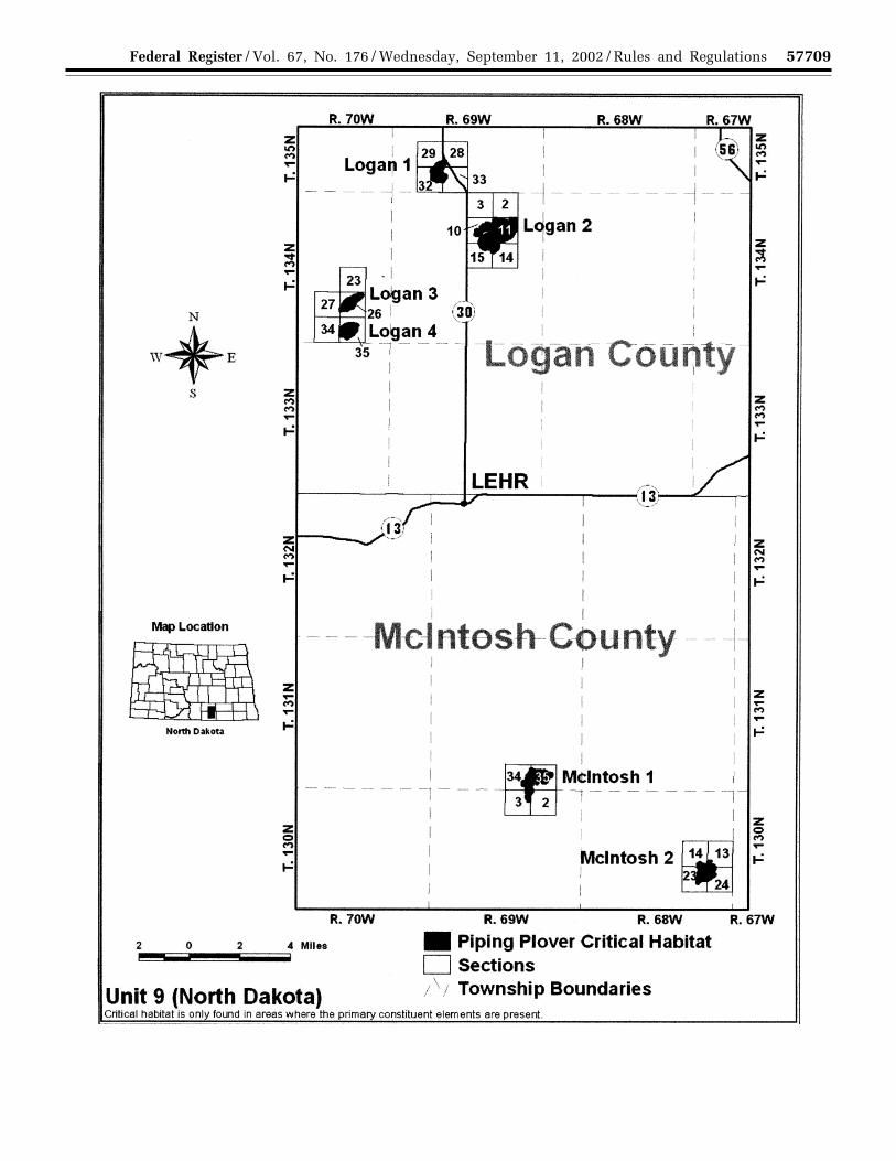


![4000-01-U DEPARTMENT OF EDUCATION 34 CFR Chapter III ...€¦ · DEPARTMENT OF EDUCATION 34 CFR Chapter III [Docket ID ED-2020-OSERS-0014] Proposed priorities, requirements, and selection](https://static.documents.pub/doc/80x56/5f06ab6a7e708231d41925c0/4000-01-u-department-of-education-34-cfr-chapter-iii-department-of-education.jpg)


![[4830-01-u] DEPARTMENT OF THE TREASURY Internal Revenue ... · DEPARTMENT OF THE TREASURY Internal Revenue Service 26 CFR Part 1 ... Regulations (26 CFR part 1) to ... on January](https://static.documents.pub/doc/80x56/5af713417f8b9a9e59903e35/4830-01-u-department-of-the-treasury-internal-revenue-of-the-treasury-internal.jpg)


