38
Deployment and Integration Patterns with Esri Roads and Highways Tom Brenneman, William Isley

Deployment and Integration Patterns with Esri Roads and Highways
Tom Brenneman, William Isley

Agenda
• Product Overview • Architecture • Asset System Integration • Data Model • Release Schedule • REST Services Sneak Peak

Product Overview

DOT Challenges
• Many business systems and LRSs
• Business data siloed
• Data not easily accessed by other systems
• Latency in propagation of updates
• Challenging or expensive integration
• GIS not well integrated
Enterprise GIS
Other Systems
Traffic
Pavement
Roadway inventory
Bridge
Safety

Roads and Highways Solution
• Centralized LRS management in GIS
• Continue to manage event data in system of choice
• Support for multiple Linear Referencing Methods (LRM)
• Event measure are updated as a result of network edits
• Communicating external system measure updates
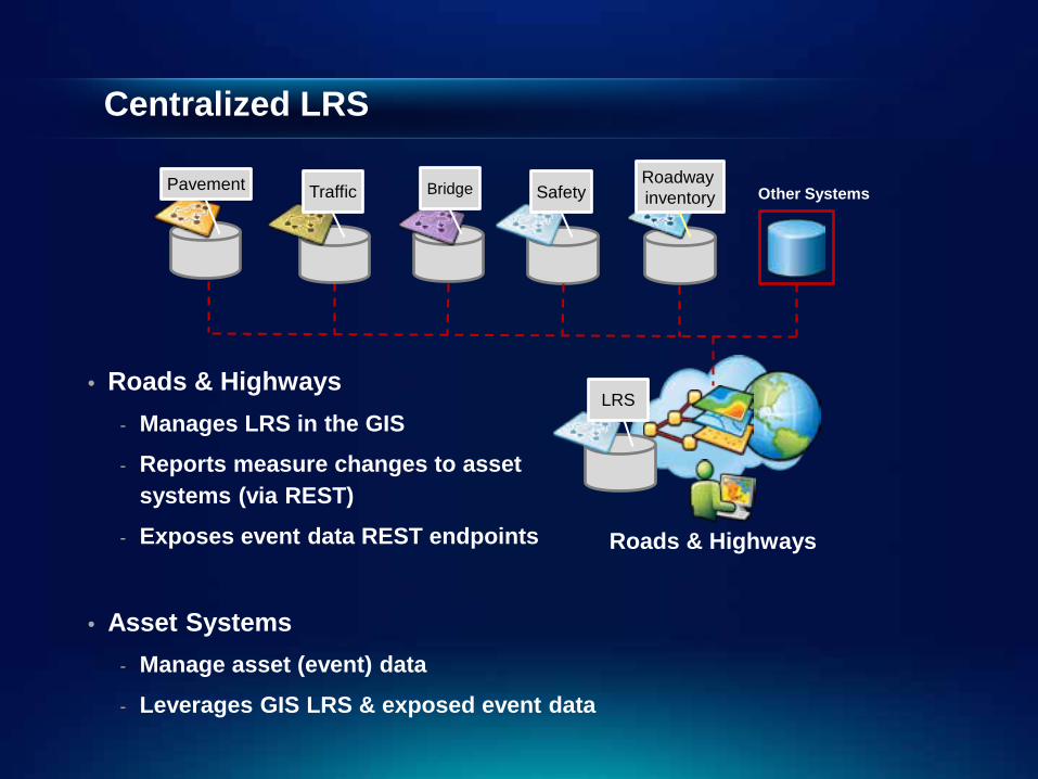
Centralized LRS
• Roads & Highways - Manages LRS in the GIS
- Reports measure changes to asset systems (via REST)
- Exposes event data REST endpoints
• Asset Systems - Manage asset (event) data
- Leverages GIS LRS & exposed event data
Other Systems
Traffic Pavement Roadway inventory Bridge
Roads & Highways
Safety
LRS
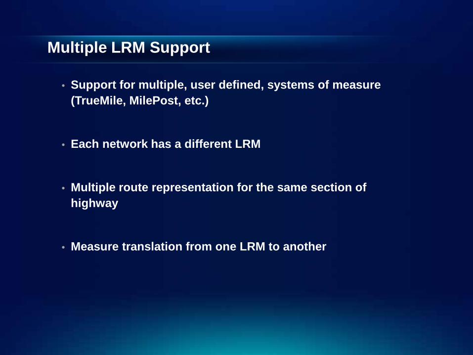
Multiple LRM Support
• Support for multiple, user defined, systems of measure (TrueMile, MilePost, etc.)
• Each network has a different LRM
• Multiple route representation for the same section of highway
• Measure translation from one LRM to another

Demonstration (Multiple LRMs)

Editing Workflows
• Create Route
• Extend Route
• Realign Route
• Reassign Route
• Retire Route
• Calibration
0 100
0 100
120
0 100
retired
0 100
1-10 retired
0 100 52
20 80
20 80
20 80
I-110 I-10 I-10
0 100

Event Measure Behaviors Before Realignment
Stay Put
Move
Snap
• When the LRS routes are edited, measure behavior rules can be applied to events.
• Events can have a different behavior for each type of LRS edit
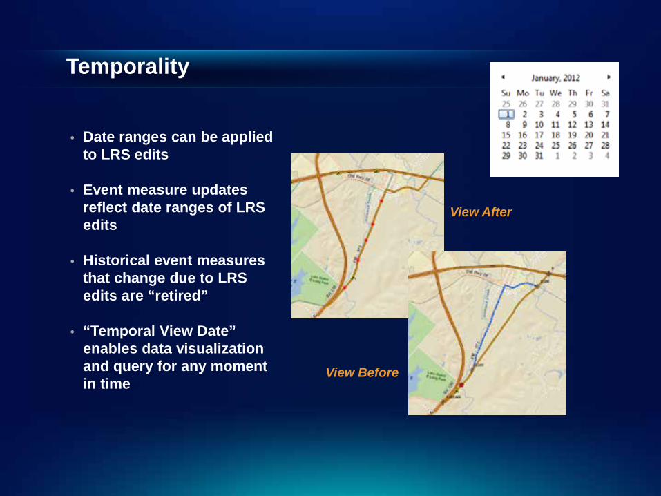
Temporality
View After
View Before
• Date ranges can be applied to LRS edits
• Event measure updates reflect date ranges of LRS edits
• Historical event measures that change due to LRS edits are “retired”
• “Temporal View Date” enables data visualization and query for any moment in time

Demonstration (Event Edit w/ Behaviors - Temporality)
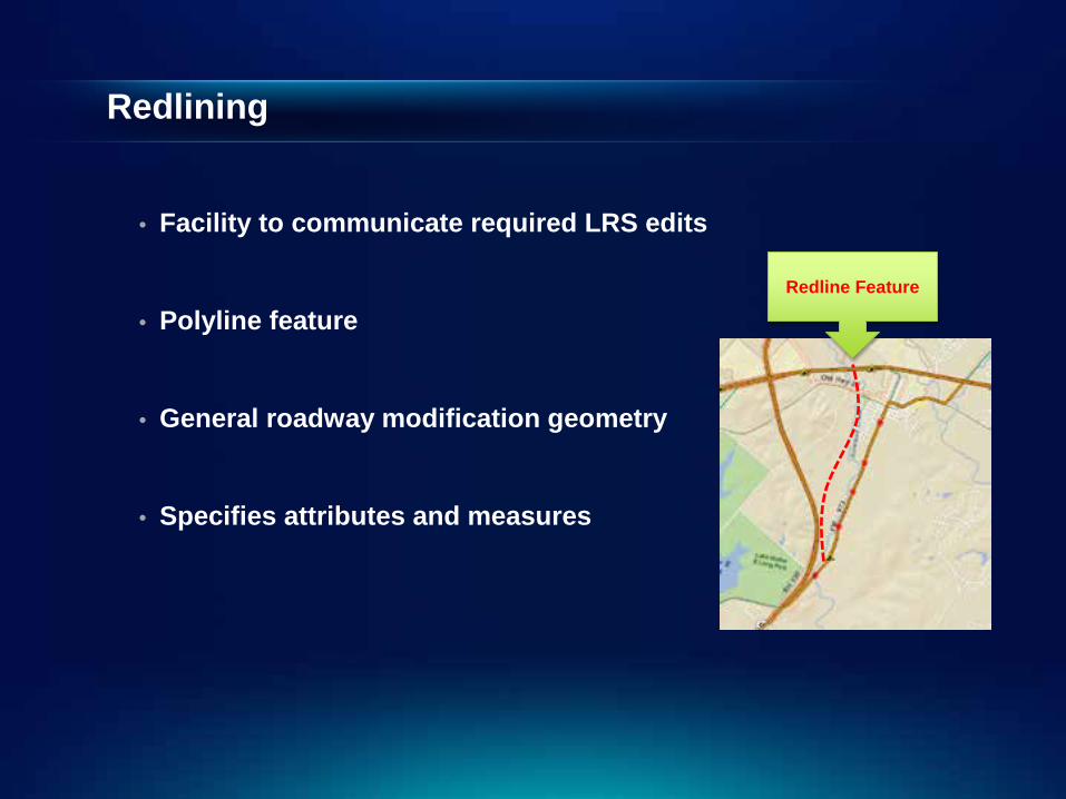
Redlining
• Facility to communicate required LRS edits
• Polyline feature
• General roadway modification geometry
• Specifies attributes and measures
Redline Feature

Demonstration (Web Redlining)
Server Architecture
• Augments Map Service - Network and Event Layers
- Mapping and query of events and networks
• Server Object Extension - LRS Server REST endpoints
- Acquire external event measure changes
- More in May release…
• Read-Only External System Access
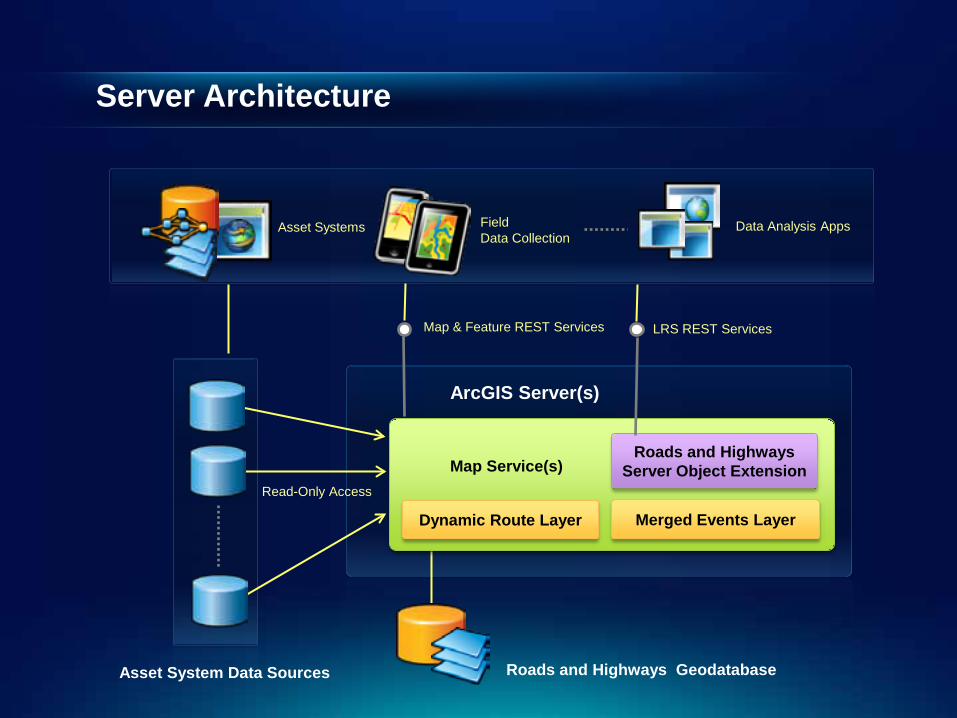
ArcGIS Server(s)
Server Architecture
Map Service(s)
Roads and Highways Server Object Extension
Roads and Highways Geodatabase Asset System Data Sources
Read-Only Access
LRS REST Services Map & Feature REST Services
Asset Systems Field Data Collection
Data Analysis Apps
Dynamic Route Layer Merged Events Layer

External System Integration
• External table registered with LRS - Connection information to table
- Event ID and measure columns
- To / From Dates (optional)
- Measure behaviors defined
• Event measure updates staged upon LRS edits
• REST service to acquire changes
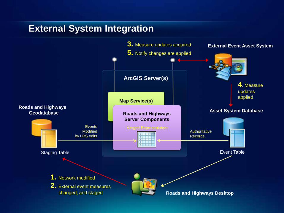
External System Integration
ArcGIS Server(s)
Map Service(s) Roads and Highways
Server Components
Roads and Highways Geodatabase Asset System Database
Staging Table Event Table
Authoritative Records
Events Modified
by LRS edits
Merged Representation
3. Measure updates acquired
5. Notify changes are applied
4. Measure updates applied
Roads and Highways Desktop
External Event Asset System
1. Network modified
2. External event measures changed, and staged

Security
• Network & events exposed via REST Services
• Data sources published in a service map document - Service protected by token service
- Roles / groups given access at service level
- Users assigned to roles groups
- Username and password used to acquire a token
- Each request to a service must pass a token
• ArcGIS Server Security Providers - SQL Server
- LDAP (Active Directory)
- Custom
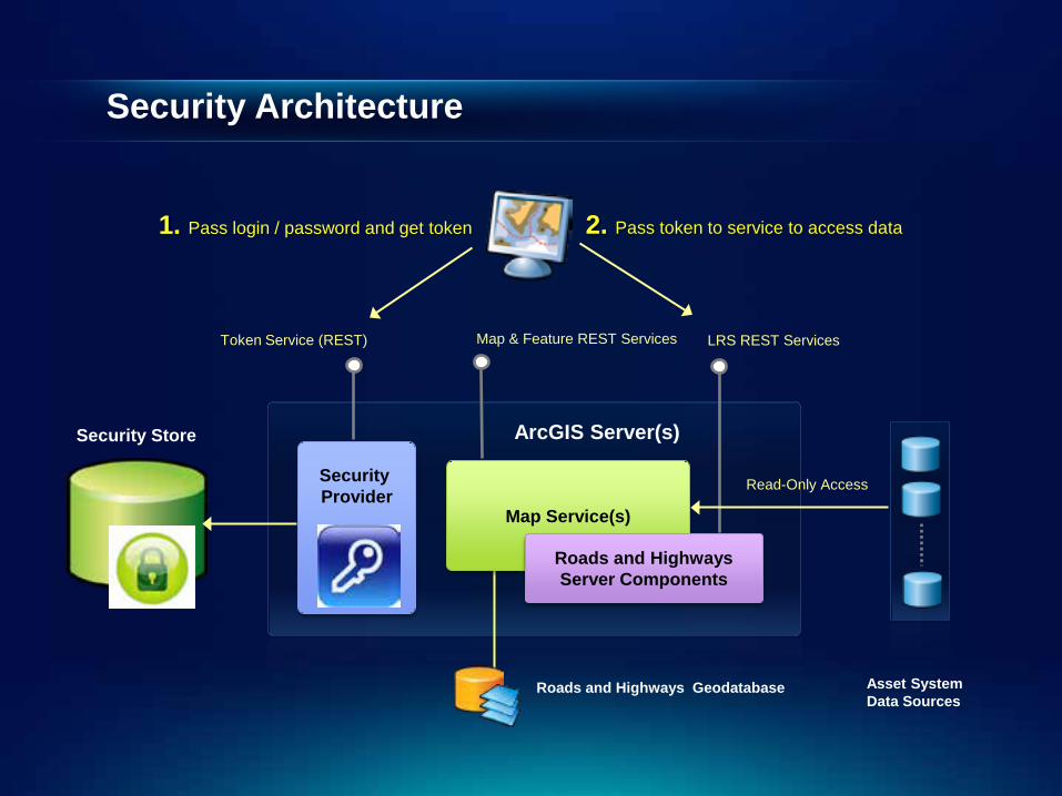
Security Architecture
ArcGIS Server(s)
Map Service(s)
Roads and Highways Server Components
Roads and Highways Geodatabase Asset System Data Sources
Read-Only Access
LRS REST Services Map & Feature REST Services
Security Store
Security Provider
Token Service (REST)
1. Pass login / password and get token 2. Pass token to service to access data

Demonstration (REST)

Data Model

Centerline
LRS Network A
LRS Network B
Dynamic routes
• Dynamic routes are generated from centerline geometry and calibration point measures
30 0
-5 45
• Two routes
• 4 Calibration points
• 3 centerlines
The two routes above are derived from three centerline lines
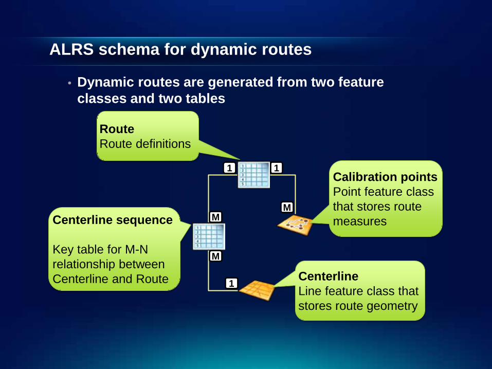
ALRS schema for dynamic routes
• Dynamic routes are generated from two feature classes and two tables
Centerline sequence Key table for M-N relationship between Centerline and Route
Route Route definitions
Calibration points Point feature class that stores route measures
Centerline Line feature class that stores route geometry
1
M
M
1
M
1

Detailed dynamic routes data model
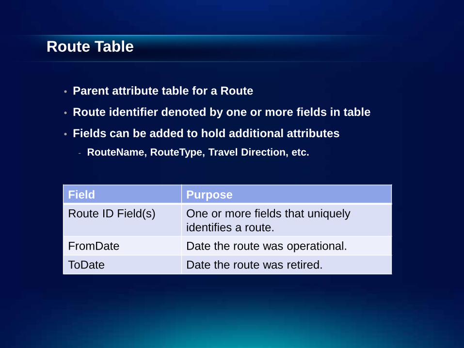
Route Table
• Parent attribute table for a Route
• Route identifier denoted by one or more fields in table
• Fields can be added to hold additional attributes - RouteName, RouteType, Travel Direction, etc.
Field Purpose Route ID Field(s) One or more fields that uniquely
identifies a route. FromDate Date the route was operational. ToDate Date the route was retired.

Centerline Feature Class
• Line feature class that holds route geometry
• Route is made of one or more Centerline features
• Centerline features can be “shared” by different routes
• Managed by Roads and Highways – Do not edit
Field Purpose RoadwayId
Unique ID (GUID) for the centerline geometry. Can be either integer or string.
FromDate Date centerline feature was operational. ToDate Date centerline feature was retired.
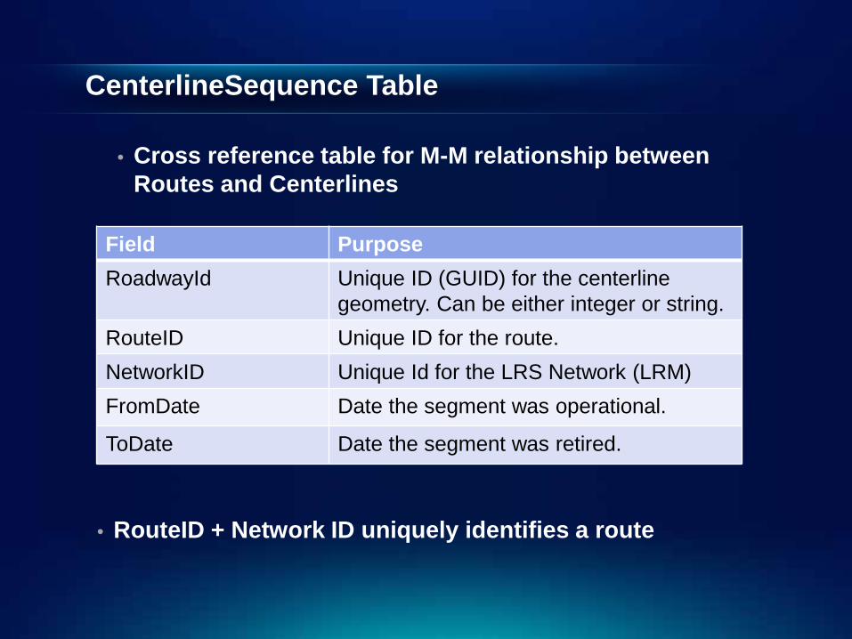
CenterlineSequence Table
• Cross reference table for M-M relationship between Routes and Centerlines
Field Purpose RoadwayId
Unique ID (GUID) for the centerline geometry. Can be either integer or string.
RouteID Unique ID for the route. NetworkID Unique Id for the LRS Network (LRM) FromDate Date the segment was operational.
ToDate Date the segment was retired.
• RouteID + Network ID uniquely identifies a route
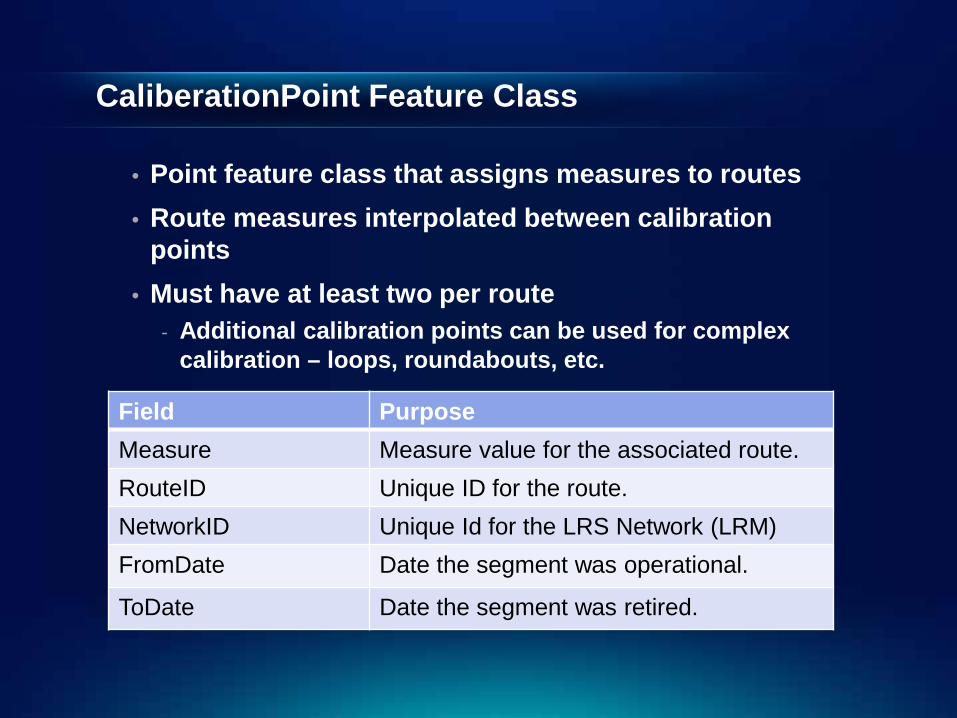
CaliberationPoint Feature Class
• Point feature class that assigns measures to routes • Route measures interpolated between calibration
points • Must have at least two per route
- Additional calibration points can be used for complex calibration – loops, roundabouts, etc.
Field Purpose Measure Measure value for the associated route. RouteID Unique ID for the route. NetworkID Unique Id for the LRS Network (LRM) FromDate Date the segment was operational.
ToDate Date the segment was retired.
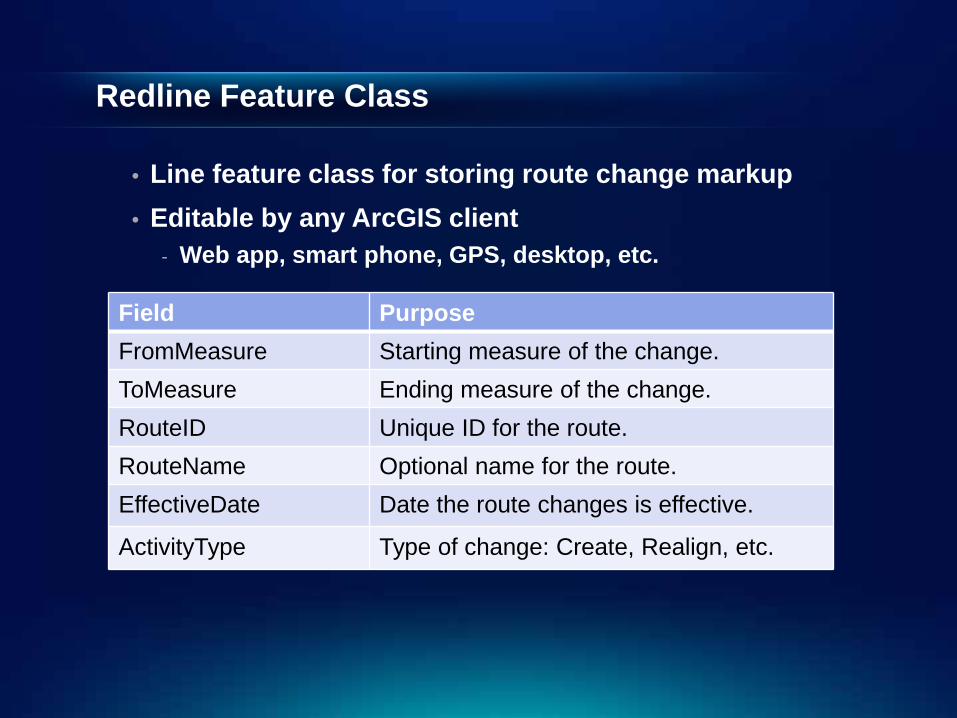
Redline Feature Class
• Line feature class for storing route change markup • Editable by any ArcGIS client
- Web app, smart phone, GPS, desktop, etc.
Field Purpose FromMeasure Starting measure of the change. ToMeasure Ending measure of the change. RouteID Unique ID for the route. RouteName Optional name for the route. EffectiveDate Date the route changes is effective.
ActivityType Type of change: Create, Realign, etc.
Demonstration (Setting up ALRS)
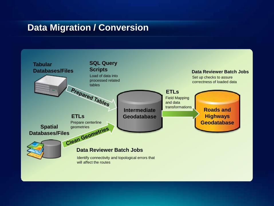
Data Migration / Conversion
Roads and Highways
Geodatabase
Tabular Databases/Files
Intermediate Geodatabase
ETLs
SQL Query Scripts Load of data into processed related tables
Field Mapping and data transformations
Spatial Databases/Files
Data Reviewer Batch Jobs Identify connectivity and topological errors that will affect the routes
ETLs Prepare centerline geometries
Data Reviewer Batch Jobs Set up checks to assure correctness of loaded data

Data Migration / Conversion
• Create Intermediate Database - Centerlines and Centerline Sequence (unclean)
• Clean Data - Reviewer to find dangles and topology errors, out of range measures, …
• Create Roads and Highways data model
• Transform into Data Model - SQL Scripts, ArcMap Simple Data Loader, FME, …
- Centerline, Centerline Sequence, Routes
• Create Calibration Points - Use Roads and Highways GP tools
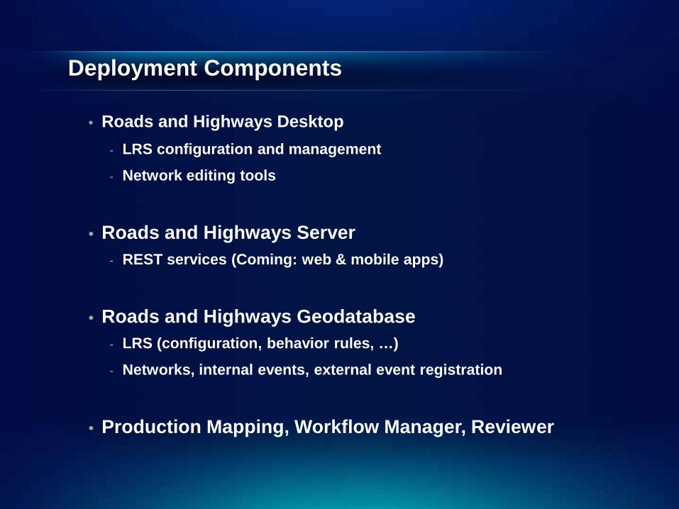
Deployment Components
• Roads and Highways Desktop - LRS configuration and management
- Network editing tools
• Roads and Highways Server - REST services (Coming: web & mobile apps)
• Roads and Highways Geodatabase - LRS (configuration, behavior rules, …)
- Networks, internal events, external event registration
• Production Mapping, Workflow Manager, Reviewer
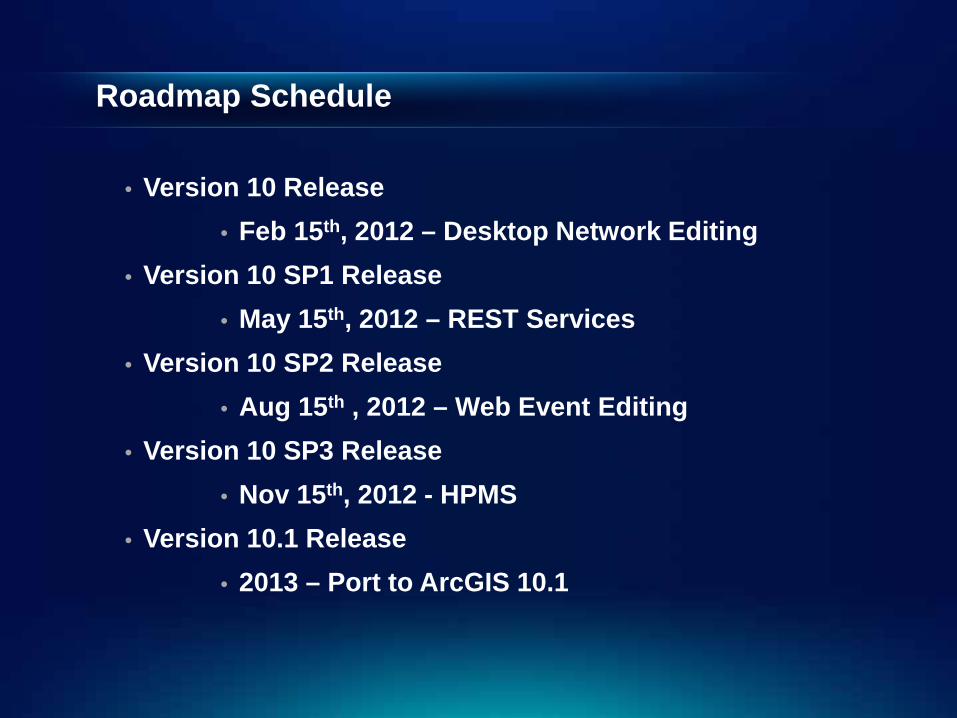
Roadmap Schedule
• Version 10 Release • Feb 15th, 2012 – Desktop Network Editing
• Version 10 SP1 Release • May 15th, 2012 – REST Services
• Version 10 SP2 Release • Aug 15th , 2012 – Web Event Editing
• Version 10 SP3 Release • Nov 15th, 2012 - HPMS
• Version 10.1 Release • 2013 – Port to ArcGIS 10.1
Demo (Sneak Peak of REST in SP1)

Questions?


